
Old Coast Road
Encyclopedia
Old Coast Road is a Western Australia
n highway linking Mandurah, WA's second-largest city located 75 km south of Perth
, with Bunbury
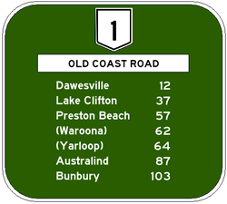
, WA's third-largest city. It is signed as Route 1 for most of its length and is 96 kilometres (59.7 mi) long.
. For most of its length, the road went through well-timbered, sandy limestone country of little value to agriculture. The area's first European settler was John Fouracre, who built a house in this area in 1852 and had established a wayside inn and changing station at Wellington Location 205 in 1854. Settlement was slow due to poor soils in the district, although as soil technology improved, additives such as superphosphate were added to soils.
After World War II
, demand increased for homes in the Myalup
-Binningup
region. At this point, the South Western Highway
through Armadale
, Pinjarra
and Harvey
some 20-30km to the east was signed Route 1 and carried most traffic from Perth to Bunbury. The name "Old Coast Road" was formally adopted on 27 January 1959.
 In the 1950s, Kwinana
was developed as Western Australia's primary heavy industrial area, and from the 1960s onwards, Rockingham
and Mandurah
, previously small villages inhabited by holidaymakers and retirees and servicing low-level agricultural districts, began to develop rapidly into residential cities - by 2001, Rockingham, Mandurah and Bunbury would each have over 50,000 people, and Perth well on its way to 1.5 million. At the same time, the South West became increasingly popular as a tourist destination, made closer to Australia and the world by improved air travel.
Old Coast Road was, exactly as its name suggests, the "old coast road" - a single carriageway, two-lane road - and neither it nor the town centre of Mandurah had ever been designed to cope with the new realities.
In 1983, the Australian Labor Party
under Brian Burke
was elected to office for the first time in over 10 years with a development platform which promoted the growth of regional cities and the building of infrastructure to support that growth. At that time, Old Coast Road started from the end of Pinjarra Road at the west end of the Mandurah Bridge adjacent to Mandurah's town centre, and was a single carriageway road leading out of Mandurah's southern suburbs and on to Bunbury. Neither Mary Street nor the canal estate existed, and Leighton Road was a minor distributor road into northern Halls Head
.
By 1987, Mandurah Road had been built around Mandurah's south and inner east, bypassing Halls Head and the Mandurah Bridge and town centre, and bringing traffic onto the original Fremantle Road at Silver Sands
(then called Mandurah Road), and onto a Rockingham
bypass, Ennis Avenue, originally constructed as a minor regional road in the late 1970s and later upgraded. In 1988, Rockingham was declared a City, and in 1990, Mandurah followed.
At the other end of the road, Bunbury was growing as well. In 1988-1989, after expansion of Bunbury's port, a number of industries, including a titanium dioxide
pigment factory and a silicon
producing smelter, opened at Kemerton
, just off the Old Coast Road near Australind, Western Australia
. Residential growth in Eaton
and Australind increased during the 1980s. The Bunbury Tower was built in 1986, and State government departments opened up offices there. By 2001, Australind had grown to house 5,900 people. In the late 1990s, the Australind Bypass was built to relieve pressure on Old Coast Road.
The next stage was to extend the Kwinana Freeway
from its former terminus at Safety Bay Road, Baldivis
, to Pinjarra Road, and to construct the Forrest Highway from the Pinjarra Road to meet with Old Coast Road at Lake Clifton. This road was opened on 20 September 2009.
Sections of the Old Coast Road are considered notorious, claiming many road accident victims. Data from the Main Roads Department show that between 1996 and 2006 there were 1,560 serious crashes, with 42 fatalities.. Some residents who live on the 30km Single Lane Carriageway call Old Coast as 'Old Ghost Road'
, as a minor regional road serving the canal estate in eastern Halls Head. Prior to the construction of the canal estate in 1986-87, this was part of the main route through Mandurah to Perth and fed onto the Mandurah Bridge as "Pinjarra Road", while Leighton Road became a minor regional road into northern Halls Head.
Old Coast Road then turns right at Mandurah Road and takes on Route 1, becoming a dual carriageway
at this point. It then proceeds through Mandurah's southern suburbs of Falcon
and Wannanup
(Port Bouvard) and crosses the Dawesville Channel on a four-lane bridge. About 1km later, the highway becomes the "Dawesville Bypass", with Old Coast Road turning off into a minor north-south regional road through the eastern part of Dawesville
before resuming with the highway.
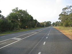
 The highway reduces to a single carriageway and goes through Bouvard
, Herron
and Lake Clifton
. Many residents call this road Old 'Ghost' Road with the number of accidents and fatalities on that single carriageway stretch sinch 1997. With a number of deaths between August 2008 and February 2009 on the 30km stretch between Tims Thicket Road and Johnston Road, this has made Mainroads Western Australia reduce the speed limit from 110km/h to 100km/h an hour in both directions.
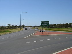
The road then abruptly terminates at a roundabout linking the road to an at-grade intersection
with Forrest Highway. Forrest Highway reverts back to Old Coast Road while remaining a dual carriageway, passing turnoffs to Preston Beach
, Myalup
and Binningup
. The countryside for this part is mostly jarrah
and marri
forest with some wetland vegetation and some cleared land being used for farming, especially around Myalup.
Just after the turnoff to the Kemerton Industrial Estate, Route 1 follows onto the Australind Bypass, while Old Coast Road turns off, passing entrances to the rural residential suburb of Leschenault
before entering Australind
.
and Pelican Point
. It then comes to an end at the Australind Bypass in the suburb of Glen Iris, about 6 km from Bunbury's CBD
.
Western Australia
Western Australia is a state of Australia, occupying the entire western third of the Australian continent. It is bounded by the Indian Ocean to the north and west, the Great Australian Bight and Indian Ocean to the south, the Northern Territory to the north-east and South Australia to the south-east...
n highway linking Mandurah, WA's second-largest city located 75 km south of Perth
Perth, Western Australia
Perth is the capital and largest city of the Australian state of Western Australia and the fourth most populous city in Australia. The Perth metropolitan area has an estimated population of almost 1,700,000....
, with Bunbury
Bunbury, Western Australia
The port city of Bunbury is the third largest city in Western Australia after the State Capital Perth and Mandurah. It is situated south of Perth's central business district...
, WA's third-largest city. It is signed as Route 1 for most of its length and is 96 kilometres (59.7 mi) long.
Overview
The road started as a route built by convicts in the 1850s through Lake CliftonLake Clifton, Western Australia
Lake Clifton is a small town located on the east side of the lake of the same name in the Peel region of Western Australia just off the Old Coast Road, between Mandurah and Bunbury at the north end of the Yalgorup National Park...
. For most of its length, the road went through well-timbered, sandy limestone country of little value to agriculture. The area's first European settler was John Fouracre, who built a house in this area in 1852 and had established a wayside inn and changing station at Wellington Location 205 in 1854. Settlement was slow due to poor soils in the district, although as soil technology improved, additives such as superphosphate were added to soils.
After World War II
World War II
World War II, or the Second World War , was a global conflict lasting from 1939 to 1945, involving most of the world's nations—including all of the great powers—eventually forming two opposing military alliances: the Allies and the Axis...
, demand increased for homes in the Myalup
Myalup, Western Australia
Myalup is a town located on the coast in the South West region of Western Australia between Mandurah and Bunbury. At the 2006 census, Myalup had a population of 144.-History:...
-Binningup
Binningup, Western Australia
Binningup is a town located on the coast in the South West region of Western Australia between Mandurah and Bunbury. At the 2006 census, Binningup had a population of 950.-History:...
region. At this point, the South Western Highway
South Western Highway
South Western Highway is a highway in the South West region of Western Australia connecting Perth's southeast with Walpole. It is a part of the National Highway 1 network for most of its length...
through Armadale
Armadale, Western Australia
Armadale is a suburb within the City of Armadale, located on the south-eastern edge of Perth's metropolitan area. The major junction of the South Western and Albany Highways, which connect Perth with the South West and Great Southern regions of Western Australia respectively, is located within the...
, Pinjarra
Pinjarra, Western Australia
Pinjarra is a town in the Peel region of Western Australia along the South Western Highway, from the state capital, Perth and south-east of the coastal city of Mandurah. Its local government area is the Shire of Murray. At the 2006 census, Pinjarra had a population of 3,279.Pinjarra is an area...
and Harvey
Harvey, Western Australia
Harvey is a town located in the South West of Western Australia along the South Western Highway, 140 km south of Perth, between Pinjarra and Bunbury...
some 20-30km to the east was signed Route 1 and carried most traffic from Perth to Bunbury. The name "Old Coast Road" was formally adopted on 27 January 1959.
Kwinana, Western Australia
The Town of Kwinana is a Local Government Area of Western Australia. It covers an area of approximately 118 square kilometres in metropolitan Perth, and lies about 38 km south of Perth's central business district, via the Kwinana Freeway...
was developed as Western Australia's primary heavy industrial area, and from the 1960s onwards, Rockingham
Rockingham, Western Australia
Rockingham is a suburb and primary centre in Western Australia south-west of the Perth city centre and south of Fremantle. It has a beachside location at Mangles Bay, the southern extremity of Cockburn Sound. To its north stretches the maritime and resource-industry installations of Kwinana and...
and Mandurah
Mandurah, Western Australia
Mandurah is the second-largest city in Western Australia and is located approximately south of the state capital, Perth.The city attracts a large number of tourists, including many international visitors...
, previously small villages inhabited by holidaymakers and retirees and servicing low-level agricultural districts, began to develop rapidly into residential cities - by 2001, Rockingham, Mandurah and Bunbury would each have over 50,000 people, and Perth well on its way to 1.5 million. At the same time, the South West became increasingly popular as a tourist destination, made closer to Australia and the world by improved air travel.
Old Coast Road was, exactly as its name suggests, the "old coast road" - a single carriageway, two-lane road - and neither it nor the town centre of Mandurah had ever been designed to cope with the new realities.
In 1983, the Australian Labor Party
Australian Labor Party
The Australian Labor Party is an Australian political party. It has been the governing party of the Commonwealth of Australia since the 2007 federal election. Julia Gillard is the party's federal parliamentary leader and Prime Minister of Australia...
under Brian Burke
Brian Burke
Brian Thomas Burke was Labor premier of Western Australia from 25 February 1983 until his resignation on 25 February 1988...
was elected to office for the first time in over 10 years with a development platform which promoted the growth of regional cities and the building of infrastructure to support that growth. At that time, Old Coast Road started from the end of Pinjarra Road at the west end of the Mandurah Bridge adjacent to Mandurah's town centre, and was a single carriageway road leading out of Mandurah's southern suburbs and on to Bunbury. Neither Mary Street nor the canal estate existed, and Leighton Road was a minor distributor road into northern Halls Head
Halls Head, Western Australia
Halls Head is a coastal suburb of Mandurah, immediately west of Mandurah's central area. It is largely residential and contains several canal estates developed since the 1980s....
.
By 1987, Mandurah Road had been built around Mandurah's south and inner east, bypassing Halls Head and the Mandurah Bridge and town centre, and bringing traffic onto the original Fremantle Road at Silver Sands
Silver Sands, Western Australia
Silver Sands is an inner northern coastal suburb of Mandurah, Western Australia....
(then called Mandurah Road), and onto a Rockingham
Rockingham, Western Australia
Rockingham is a suburb and primary centre in Western Australia south-west of the Perth city centre and south of Fremantle. It has a beachside location at Mangles Bay, the southern extremity of Cockburn Sound. To its north stretches the maritime and resource-industry installations of Kwinana and...
bypass, Ennis Avenue, originally constructed as a minor regional road in the late 1970s and later upgraded. In 1988, Rockingham was declared a City, and in 1990, Mandurah followed.
At the other end of the road, Bunbury was growing as well. In 1988-1989, after expansion of Bunbury's port, a number of industries, including a titanium dioxide
Titanium dioxide
Titanium dioxide, also known as titanium oxide or titania, is the naturally occurring oxide of titanium, chemical formula . When used as a pigment, it is called titanium white, Pigment White 6, or CI 77891. Generally it comes in two different forms, rutile and anatase. It has a wide range of...
pigment factory and a silicon
Silicon
Silicon is a chemical element with the symbol Si and atomic number 14. A tetravalent metalloid, it is less reactive than its chemical analog carbon, the nonmetal directly above it in the periodic table, but more reactive than germanium, the metalloid directly below it in the table...
producing smelter, opened at Kemerton
Kemerton, Western Australia
Kemerton is an industrial park in the Bunbury region of Western Australia, about 10km north-east of Australind. Its Local Government Area is the Shire of Harvey.-Description:...
, just off the Old Coast Road near Australind, Western Australia
Australind, Western Australia
Australind is a satellite town and outer northern suburb of Bunbury, Western Australia, and is located 12 km north-east of Bunbury's central business district. Its Local Government Area is the Shire of Harvey. At the 2006 census, Australind had a population of 8,717. -History:Prior to European...
. Residential growth in Eaton
Eaton, Western Australia
Eaton is a northeastern suburb of Bunbury, Western Australia, located 7 km from the centre of Bunbury on the south shore of the Collie River. Its Local Government Area is the Shire of Dardanup, and the offices for the Shire are located within the suburb....
and Australind increased during the 1980s. The Bunbury Tower was built in 1986, and State government departments opened up offices there. By 2001, Australind had grown to house 5,900 people. In the late 1990s, the Australind Bypass was built to relieve pressure on Old Coast Road.
The next stage was to extend the Kwinana Freeway
Kwinana Freeway
The Kwinana Freeway is a major arterial road in Perth, Western Australia, linking Perth with the southern suburbs and then further on towards Mandurah, a distance of . It has a speed limit of , except in central Perth and south of Lakes Road . Like all Western Australian freeways, the minimum...
from its former terminus at Safety Bay Road, Baldivis
Baldivis, Western Australia
Baldivis is a semi-rural residential suburb south of the central business district of Perth, the capital of Western Australia, and southeast of the regional centre of Rockingham...
, to Pinjarra Road, and to construct the Forrest Highway from the Pinjarra Road to meet with Old Coast Road at Lake Clifton. This road was opened on 20 September 2009.
Sections of the Old Coast Road are considered notorious, claiming many road accident victims. Data from the Main Roads Department show that between 1996 and 2006 there were 1,560 serious crashes, with 42 fatalities.. Some residents who live on the 30km Single Lane Carriageway call Old Coast as 'Old Ghost Road'
In Mandurah
The road starts at a roundabout in Mary Street, Halls HeadHalls Head, Western Australia
Halls Head is a coastal suburb of Mandurah, immediately west of Mandurah's central area. It is largely residential and contains several canal estates developed since the 1980s....
, as a minor regional road serving the canal estate in eastern Halls Head. Prior to the construction of the canal estate in 1986-87, this was part of the main route through Mandurah to Perth and fed onto the Mandurah Bridge as "Pinjarra Road", while Leighton Road became a minor regional road into northern Halls Head.
Old Coast Road then turns right at Mandurah Road and takes on Route 1, becoming a dual carriageway
Dual carriageway
A dual carriageway is a class of highway with two carriageways for traffic travelling in opposite directions separated by a central reservation...
at this point. It then proceeds through Mandurah's southern suburbs of Falcon
Falcon, Western Australia
Falcon is a southern suburb of Mandurah, located southwest of Mandurah's central area on the Indian Ocean.-Geography:Falcon is one of four Mandurah suburbs that lie on an island bound by the Mandurah Estuary to the north, the Peel-Harvey Estuary to the east, the Dawesville Channel to the south and...
and Wannanup
Wannanup, Western Australia
Wannanup is a residential suburb in Western Australia, located southwest of Mandurah and south-southwest of the state capital, Perth. It is surrounded on three sides by water — the Indian Ocean to the west, the Harvey Estuary to the east and the Dawesville Channel to the south — and is home to...
(Port Bouvard) and crosses the Dawesville Channel on a four-lane bridge. About 1km later, the highway becomes the "Dawesville Bypass", with Old Coast Road turning off into a minor north-south regional road through the eastern part of Dawesville
Dawesville, Western Australia
Dawesville is a suburb of Mandurah, and is located between the Harvey Estuary and the Indian Ocean.It is also home to the largest inland waterway in Western Australia - the Harvey Estuary and the Peel Inlet which combine to produce an array of fishing and crabbing options in the summer months...
before resuming with the highway.
Mandurah to Australind
Bouvard, Western Australia
Bouvard is the southernmost suburb of Mandurah, Western Australia, and is located south of the state capital, Perth. Its Local Government Area is the City of Mandurah.-History:...
, Herron
Herron, Western Australia
Herron is a small town located in the Peel region of Western Australia just off the Old Coast Road, between Mandurah and Bunbury just beyond Mandurah's urban area...
and Lake Clifton
Lake Clifton, Western Australia
Lake Clifton is a small town located on the east side of the lake of the same name in the Peel region of Western Australia just off the Old Coast Road, between Mandurah and Bunbury at the north end of the Yalgorup National Park...
. Many residents call this road Old 'Ghost' Road with the number of accidents and fatalities on that single carriageway stretch sinch 1997. With a number of deaths between August 2008 and February 2009 on the 30km stretch between Tims Thicket Road and Johnston Road, this has made Mainroads Western Australia reduce the speed limit from 110km/h to 100km/h an hour in both directions.
The road then abruptly terminates at a roundabout linking the road to an at-grade intersection
At-grade intersection
An at-grade intersection is a junction at which two or more transport axes cross at the same level .-Traffic management:With areas of high or fast traffic, an at-grade intersection normally requires a traffic control device such as a stop sign, traffic light or railway signal to manage conflicting...
with Forrest Highway. Forrest Highway reverts back to Old Coast Road while remaining a dual carriageway, passing turnoffs to Preston Beach
Preston Beach, Western Australia
Preston Beach is a small town located in the Peel region of Western Australia just off the Old Coast Road, between Mandurah and Bunbury in the Yalgorup National Park.-History:...
, Myalup
Myalup, Western Australia
Myalup is a town located on the coast in the South West region of Western Australia between Mandurah and Bunbury. At the 2006 census, Myalup had a population of 144.-History:...
and Binningup
Binningup, Western Australia
Binningup is a town located on the coast in the South West region of Western Australia between Mandurah and Bunbury. At the 2006 census, Binningup had a population of 950.-History:...
. The countryside for this part is mostly jarrah
Jarrah
Eucalyptus marginata is one of the most common species of Eucalyptus tree in the southwest of Western Australia. The tree and the wood are usually referred to by the Aboriginal name Jarrah...
and marri
Corymbia calophylla
Corymbia calophylla is a bloodwood native to Western Australia. Common names include Marri and Port Gregory Gum, and a long standing usage has been Red Gum due to the red gum effusions often found on trunks.It is distinctive among bloodwoods for its very large buds and fruit Corymbia calophylla...
forest with some wetland vegetation and some cleared land being used for farming, especially around Myalup.
Just after the turnoff to the Kemerton Industrial Estate, Route 1 follows onto the Australind Bypass, while Old Coast Road turns off, passing entrances to the rural residential suburb of Leschenault
Leschenault, Western Australia
Leschenault is an outer suburb of Bunbury, Western Australia, and is located 16 km to the north-east. Its Local Government Area is the Shire of Harvey.-History:...
before entering Australind
Australind, Western Australia
Australind is a satellite town and outer northern suburb of Bunbury, Western Australia, and is located 12 km north-east of Bunbury's central business district. Its Local Government Area is the Shire of Harvey. At the 2006 census, Australind had a population of 8,717. -History:Prior to European...
.
Australind to Bunbury
The road travels for about 4 km before bridging the Collie River and passing EatonEaton, Western Australia
Eaton is a northeastern suburb of Bunbury, Western Australia, located 7 km from the centre of Bunbury on the south shore of the Collie River. Its Local Government Area is the Shire of Dardanup, and the offices for the Shire are located within the suburb....
and Pelican Point
Pelican Point, Western Australia
Pelican Point is a northeastern suburb of Bunbury, Western Australia, adjoining Eaton and located 6 km from the centre of Bunbury. Its Local Government Area is the City of Bunbury.-History:...
. It then comes to an end at the Australind Bypass in the suburb of Glen Iris, about 6 km from Bunbury's CBD
Central business district
A central business district is the commercial and often geographic heart of a city. In North America this part of a city is commonly referred to as "downtown" or "city center"...
.
Major intersections
-
 (at Halls Head) Mandurah Road to RockinghamRockingham, Western AustraliaRockingham is a suburb and primary centre in Western Australia south-west of the Perth city centre and south of Fremantle. It has a beachside location at Mangles Bay, the southern extremity of Cockburn Sound. To its north stretches the maritime and resource-industry installations of Kwinana and...
and PerthPerth, Western AustraliaPerth is the capital and largest city of the Australian state of Western Australia and the fourth most populous city in Australia. The Perth metropolitan area has an estimated population of almost 1,700,000....
. - (at Dawesville) Dawesville Bypass (both ends)
- (at Herron) Old Bunbury Road to PinjarraPinjarra, Western AustraliaPinjarra is a town in the Peel region of Western Australia along the South Western Highway, from the state capital, Perth and south-east of the coastal city of Mandurah. Its local government area is the Shire of Murray. At the 2006 census, Pinjarra had a population of 3,279.Pinjarra is an area...
-
 (at Lake Clifton) Forrest Highway to South YunderupSouth Yunderup, Western AustraliaSouth Yunderup is a township near Mandurah, Western Australia, located on the south bank of the Murray River within the Shire of Murray. Its postcode is 6208, and in the 2006 Census, it had a population of 1,965 with a median age of 50...
and PerthPerth, Western AustraliaPerth is the capital and largest city of the Australian state of Western Australia and the fourth most populous city in Australia. The Perth metropolitan area has an estimated population of almost 1,700,000.... - (at Myalup) Forestry Road/Uduc Road to HarveyHarvey, Western AustraliaHarvey is a town located in the South West of Western Australia along the South Western Highway, 140 km south of Perth, between Pinjarra and Bunbury...
- (at Binningup) Binningup Road to BinningupBinningup, Western AustraliaBinningup is a town located on the coast in the South West region of Western Australia between Mandurah and Bunbury. At the 2006 census, Binningup had a population of 950.-History:...
- (at Leschenault) Wellesley, Treasure and Marriott Roads to KemertonKemerton, Western AustraliaKemerton is an industrial park in the Bunbury region of Western Australia, about 10km north-east of Australind. Its Local Government Area is the Shire of Harvey.-Description:...
and Brunswick JunctionBrunswick Junction, Western AustraliaBrunswick Junction is a town located in the South West of Western Australia along the South Western Highway, between Harvey and Bunbury.-History:... - (at Leschenault) Australind Bypass to BunburyBunbury, Western AustraliaThe port city of Bunbury is the third largest city in Western Australia after the State Capital Perth and Mandurah. It is situated south of Perth's central business district...
- (at Australind) Paris Road to Brunswick JunctionBrunswick Junction, Western AustraliaBrunswick Junction is a town located in the South West of Western Australia along the South Western Highway, between Harvey and Bunbury.-History:...
via Clifton Road - (at Pelican Point) Hamilton Road to EatonEaton, Western AustraliaEaton is a northeastern suburb of Bunbury, Western Australia, located 7 km from the centre of Bunbury on the south shore of the Collie River. Its Local Government Area is the Shire of Dardanup, and the offices for the Shire are located within the suburb....
; Estuary Drive to BunburyBunbury, Western AustraliaThe port city of Bunbury is the third largest city in Western Australia after the State Capital Perth and Mandurah. It is situated south of Perth's central business district...
(scenic route) - (at Glen Iris) Australind Bypass to PerthPerth, Western AustraliaPerth is the capital and largest city of the Australian state of Western Australia and the fourth most populous city in Australia. The Perth metropolitan area has an estimated population of almost 1,700,000....