

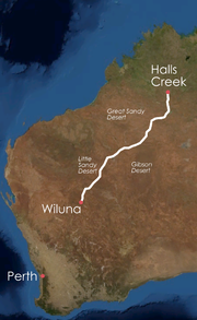
Canning Stock Route
Encyclopedia
Halls Creek, Western Australia
Halls Creek is a small town situated in the East Kimberley region of Western Australia. It is located between the towns of Fitzroy Crossing and Turkey Creek on the Great Northern Highway...
from Wiluna
Wiluna, Western Australia
Wiluna is a complex town in the Mid West region of Western Australia. It is situated on the edge of the Western Desert at the gateway to the Canning Stock Route and Gunbarrel Highway. It is the service centre of the local area for the local Aboriginal people, the pastoral industry, mining, and...
, both in Western Australia
Western Australia
Western Australia is a state of Australia, occupying the entire western third of the Australian continent. It is bounded by the Indian Ocean to the north and west, the Great Australian Bight and Indian Ocean to the south, the Northern Territory to the north-east and South Australia to the south-east...
. With a total distance of around 1850 km (1,149.5 mi) it is also the longest historic stock route
Stock route
In Australia, the Travelling Stock Route is an authorised thoroughfare for the walking of domestic livestock such as sheep or cattle from one location to another...
in the world. For the first few hundred kilometres it runs concurrent with the Tanami Track
Tanami Track
The Tanami Road, also known as the Tanami Track and the McGuire Track, is a road in northern Australia. It follows a cattle droving route northwest from the MacDonnell Ranges area of central Australia just north of Alice Springs to Halls Creek in the Kimberley.The Tanami Road is the most direct...
.
History
In Western Australia at the beginning of the 20th century, east KimberleyKimberley region of Western Australia
The Kimberley is one of the nine regions of Western Australia. It is located in the northern part of Western Australia, bordered on the west by the Indian Ocean, on the north by the Timor Sea, on the south by the Great Sandy and Tanami Deserts, and on the east by the Northern Territory.The region...
cattlemen were looking for a way to traverse the western deserts of Australia with their cattle as a way to break a west Kimberley monopoly that controlled the supply of beef
Beef
Beef is the culinary name for meat from bovines, especially domestic cattle. Beef can be harvested from cows, bulls, heifers or steers. It is one of the principal meats used in the cuisine of the Middle East , Australia, Argentina, Brazil, Europe and the United States, and is also important in...
to Perth
Perth, Western Australia
Perth is the capital and largest city of the Australian state of Western Australia and the fourth most populous city in Australia. The Perth metropolitan area has an estimated population of almost 1,700,000....
and the goldfields
Western Australian gold rush
In the latter part of the nineteenth century, discoveries of gold at a number of locations in Western Australia caused large influxes of prospectors from overseas and interstate, and classic gold rushes. Significant finds included:...
in the south of the state. East Kimberley cattle were infested with Boophilus ticks
Rhipicephalus microplus
Rhipicephalus microplus is an economically important tick that parasitises a variety of livestock species; it is known as the cattle tick or southern cattle tick. It has been recorded on "cattle, buffalo, horses, donkeys, goats, sheep, deer, pigs, dogs and some wild animals"...
infected with a malaria-like parasitic disease called Babesiosis
Babesiosis
Babesiosis is a malaria-like parasitic disease caused by infection with Babesia, a genus of protozoal piroplasms. After trypanosomes, Babesia are thought to be the second most common blood parasites of mammals and they can have a major impact on health of domestic animals in areas without severe...
and were prohibited from being transported to southern markets by sea due to a fear that the ticks would survive the journey and spread. This gave west Kimberley cattlemen a monopoly on the beef trade and resulted in high prices.
With east Kimberley cattlemen keen to find a way to get their cattle to market, and the Government of Western Australia
Government of Western Australia
The formation of the Government of Western Australia is prescribed in its Constitution, which dates from 1890, although it has been amended many times since then...
keen for competition to bring prices down, a 1905 proposal of a stock route through the desert was taken seriously. James Isdell, an east Kimberley pastoralist and member of the Western Australian Legislative Assembly, proposed the stock route arguing that ticks would not survive in the dry desert climate on the trip south.
Calvert and Carnegie expeditions
The route, which crossed the territories of nine different Aborigine language groupsLanguage family
A language family is a group of languages related through descent from a common ancestor, called the proto-language of that family. The term 'family' comes from the tree model of language origination in historical linguistics, which makes use of a metaphor comparing languages to people in a...
, had been explored previously in 1896 by the Calvert Expedition led by Lawrence Wells
Lawrence Wells
Lawrence Allen Wells was an Australian explorer.Wells grew up in the Mount Gambier, South Australia district, and after a short stint in a merchants office, joined the South Australian Survey Department in October 1878. In 1883 the surveyor General, G.W...
and again later that year by the Carnegie Expedition led by David Carnegie. Two members of the Calvert Expedition perished of thirst and the Carnegie Expedition suffered considerable hardships with camels dying after eating poisonous grass and a member of the party accidentally shooting himself dead. Carnegie investigated the possibility of a stock route and concluded that the route was "too barren and destitute of vegetation" and was impractical.
Wells and Carnegie both mistreated Aborigines they encountered on their expeditions, forcing them to cooperate by tying them up and encouraging them to find water. Carnegie is also believed to have fed them salt, and he was later publicly criticised for this. Evidence supports that Alfred Canning
Alfred Canning
Alfred Wernam Canning was a Western Australian government surveyor. Born at Campbellfield north of Melbourne, he started work in New South Wales as a cadet surveyor and in 1893 joined the Western Australian Department of Lands and Survey.In 1901 a royal commission resulted in Canning being...
had read both the Calvert and Carnegie expedition accounts to find out about the country (which both had described as extremely difficult terrain) and the use of Aboriginal people to find water, an example Canning followed during his own expedition.
Canning survey
After it was determined that ticks could not survive a desert crossing, the government endorsed James Isdell's scheme and funded a survey to find a stock route that would cross the Great Sandy DesertGreat Sandy Desert
The Great Sandy Desert is a desert located in the North West of Western Australia straddling the Pilbara and southern Kimberley regions. It is the second largest desert in Australia after the Great Victoria Desert and encompasses an area of...
, the Little Sandy Desert
Little Sandy Desert
The Little Sandy Desert is a desert located in Western Australia south of the Great Sandy Desert and west of the Gibson Desert. It is to the east of Great Northern Highway south of Newman and approximately 200 kilometres north of Wiluna...
and the Gibson Desert
Gibson Desert
The Gibson Desert covers a large dry area in the state of Western Australia and is still largely in an almost "pristine" state. It is about in size, making it the 5th largest desert in Australia, after the Great Sandy, Great Victoria, Tanami and Simpson deserts.-Location and description:The Gibson...
. Alfred Canning
Alfred Canning
Alfred Wernam Canning was a Western Australian government surveyor. Born at Campbellfield north of Melbourne, he started work in New South Wales as a cadet surveyor and in 1893 joined the Western Australian Department of Lands and Survey.In 1901 a royal commission resulted in Canning being...
, a surveyor with the Western Australian Department of Lands and Surveys, was appointed to survey the stock route.
Canning’s task was to find a route through 1850 kilometres of desert, from Wiluna
Wiluna, Western Australia
Wiluna is a complex town in the Mid West region of Western Australia. It is situated on the edge of the Western Desert at the gateway to the Canning Stock Route and Gunbarrel Highway. It is the service centre of the local area for the local Aboriginal people, the pastoral industry, mining, and...
in the mid west to the Kimberley in the north. He needed to find significant water sources – enough for up to 800 head of cattle, a day’s walk apart – where wells could be dug, and enough good grazing land to sustain this number of cattle during the journey south.
In 1906, with a team of 23 camels, two horses, and eight men, Canning surveyed the route completing the difficult journey from Wiluna to Halls Creek in less than six months. On 1 November 1906, shortly after arriving in Halls Creek, Canning sent a telegram to Perth stating that the finished route would "be about the best watered stock route in [the] Colony". Canning was forced to delay his return journey because of an early wet season in the Kimberley that year. The survey party left Halls Creek in late January 1907 and arrived back in Wiluna in early July 1907. During the 14-month expedition, they had trekked about 4000 km (2,485.5 mi), relying on Aboriginal guides to help them find water.
Canning had always planned to rely on Aboriginal guides to help him find water and had taken neck chains and handcuffs supplied to him by the Wiluna police to make sure local 'guides' stayed as long as he needed them. In order to gain assistance in locating water along the route, Canning captured several Martu
Martu (Indigenous Australian)
Mardu are an Australian Aboriginal people of the Western Desert. Their lands include the Percival Lakes and Pilbara regions in Western Australia...
men, chained them by the neck and forced them to lead his party to native water sources (soaks
Soakage
A soakage, or soak, is a source of water in Australian deserts.It is called thus because the water generally seeps into the sand, and is stored below, sometimes as part of an ephemeral river or creek system.-Aboriginal water source:...
). As many soaks were sacred, the Martu may have misdirected the explorers away from these, resulting in the eventual stock route winding more than was actually necessary.
Royal Commission into treatment of Aboriginal people
After the Canning survey party returned to Perth, Canning's use of Aboriginal guides came under scrutiny. The expedition's cook, Edward Blake, accused Canning of mistreating many of the Aboriginal people they met during the survey expedition. Blake objected to the use of chains and criticised the "party's 'immoral' pursuit of Aboriginal women, the theft and 'unfair' trade of Aboriginal property and the destruction of native waters". Blake was concerned that the planned wells would prevent Aboriginal people accessing water.Blake's complaints led to a Royal Commission
Royal Commission
In Commonwealth realms and other monarchies a Royal Commission is a major ad-hoc formal public inquiry into a defined issue. They have been held in various countries such as the United Kingdom, Australia, Canada, New Zealand, and Saudi Arabia...
into the Treatment of Natives by the Canning Exploration Party. Blake was unable to prove many of his claims, however Canning did admit to the use of chains. Kimberley Explorer and Lord Mayor of Perth, Alexander Forrest
Alexander Forrest
Alexander Forrest CMG, was an explorer and surveyor of Western Australia, as well as a politician.-Early life:Forrest was born at Picton, near Bunbury in Western Australia, the son of William and Margaret Forrest...
dismissed Canning's actions by claiming that all explorers behaved in this manner. Despite condemning the use of chains, the Royal Commission accepted the survey party's actions as "reasonable" and Canning and his men were exonerated of all charges, including "immorality with native women" and stealing property. The Royal Commission approved the immediate commencement of the stock route's construction. Canning was appointed to lead the construction party.
Construction
Canning left Perth in March 1908, along with 30 men, 70 camels, four wagons, 100 tonnes of food and equipment and 267 goats (for milk and meat), travelled the route again to commence the construction of well heads and water troughs at the 54 water sources identified by his earlier expedition. Canning arrived back in Wiluna in April 1910 having completed the last of 48 wells in 1910 bringing the total cost of the route to £22000 (2010: $A2.6 million).Thirty-seven of the wells were built on or near existing Aboriginal waters and were constructed in the European tradition, which made many of them inaccessible to Aboriginal people. Pulling the heavy buckets up from the bottom of the wells required the strength of three men or use of a camel. Consequentially, many Aboriginal people were injured or died while trying to access the water, either falling in and drowning or breaking bones on the windlass handle. In reprisal, buckets were cut off or timber set on fire, and by 1917 Aboriginal people had vandalised or dismantled approximately half of the wells in a bid to reclaim access to the water or to prevent drovers from using the wells. Canning's party had constructed the wells with the forced help of one of the Aboriginal peoples whose land the route traversed, the Martu
Martu (Indigenous Australian)
Mardu are an Australian Aboriginal people of the Western Desert. Their lands include the Percival Lakes and Pilbara regions in Western Australia...
.
Canning produced a detailed map of the stock route, Plan of Wiluna–Kimberley stock route exploration (showing positions of wells constructed 1908–9 and 10) on which he also recorded his observations of the land and water sources along the route. The map has become a symbol of Australia’s pioneering history.
First droving runs
Commercial droving along the stock route began in 1910. The first few droves were of small groups of horses — the first started out with 42 horses of which only nine survived the journey.The first mob of bullocks
Ox
An ox , also known as a bullock in Australia, New Zealand and India, is a bovine trained as a draft animal. Oxen are commonly castrated adult male cattle; castration makes the animals more tractable...
to attempt to use the stock route set out in January 1911; however the party of three drovers
Drover (Australian)
A drover in Australia is a person, typically an experienced stockman, who moves livestock, usually sheep or cattle, "on the hoof" over long distances. Reasons for droving may include: delivering animals to a new owner's property, taking animals to market, or moving animals during a drought in...
, George Shoesmith, James Thompson and an Aboriginal stockman who was known as 'Chinaman', were killed by Aborigines at Well 37. Thomas Cole discovered their bodies later in 1911 during the his successful drove along the stock route. In September 1911, Sergeant R.H. Pilmer led a police 'punitive expedition' to find the culprits and ensure the stock route remained open. The police made no arrests, however the expedition was considered a success after Pilmer acknowledged killing at least 10 Aborigines.
On the 7th of September 1911 it was reported that the first mob of cattle to traverse the entire length of the stock route had successfully arrived in Wiluna. The cattle had apparently gained condition on the long drove.
Despite police protection, drovers were afraid to use the track and it was rarely used for almost 20 years. Between 1911 and 1931, only eight mobs of cattle were driven along the Canning Stock Route.
Reopening of the stock route
A 1928 Royal Commission into the price of beef in Western Australia led to the re-opening of the stock route. In 1929, William Snell was commissioned to repair the wells and found that the only wells undamaged were the ones that Aboriginal people could use. Snell criticised the construction of Canning’s wells because they were difficult for Aboriginal people to use safely, and he put the destruction of the wells down to the anger and frustration people felt at being unable to access traditional water sources. Snell personally committed to making the wells more accessible to Aboriginal people:Natives cannot draw water from the Canning Stock Route wells. It takes three strong white men to land a bucket of water. It is beyond the natives power to land a bucket. They let go the handle [and] some times escape with their life but get an arm and head broken in the attempt to get away. To heal the wounds so severely inflicted and [as] a safeguard against the natives destroying the wells again I equipped the wells ... so that the native can draw water from the wells without destroying them.—William Snell
Snell started work on the refurbishment of the wells, fitting some with ladders for easier access, but he abandoned the work after well 35, accounts vary reporting that he either ran out of materials or the desert became too much for him.
In 1930, Alfred Canning (then aged 70) was commissioned to complete the work. While Snell had encountered no hostility, Canning had trouble with the Aborigines from the start but successfully completed the commission in 1931.
With these improvements, the route was used on a more regular basis although in total, it would only be used around 20 times between 1931 and 1959 when the last droving run was completed. None of the larger station
Station (Australian agriculture)
Station is the term for a large Australian landholding used for livestock production. It corresponds to the North American term ranch or South American estancia...
owners used the track as it was found that only 600 head of cattle could be supported at a time, which was 200 less than was estimated when first completed. As Carnegie had accurately reported in 1896, the track was impractical for cattle drives.
During the Second World War
World War II
World War II, or the Second World War , was a global conflict lasting from 1939 to 1945, involving most of the world's nations—including all of the great powers—eventually forming two opposing military alliances: the Allies and the Axis...
the track was upgraded at considerable expense in case it was needed for an evacuation of the north if Australia was invaded. Including horse drives there have been only 37 recorded drives between 1910 and the last run in 1959.
Traverses
When horses became scarce in the Kimberley in the 1950s due to widespread losses because of the "Walkabout PoisonCrotalaria
Crotalaria is a genus of herbaceous plants and woody shrubs in the Family Fabaceae commonly known as rattlepods. Some 600 or more species of Crotalaria are described worldwide, mostly from the tropics; at least 500 species are known from Africa. Some species of Crotalaria are grown as ornamentals...
", the stock route was used to drove horses north from around the Norseman area where they were sold to the stations.
Wally Dowling, a drover who had made nine droves along the stock route took what was probably the last horses northwards along the route in September 1951.
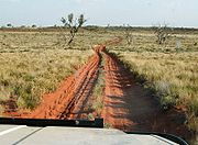
In 1968 the entire length of the track was driven for the first time. During the 1980s fuel dumps were created and adventurous travellers became interested in the history of the track and the challenge to drive it.
In 1973 (before the route was successfully negotiated in four-wheel drive
Four-wheel drive
Four-wheel drive, 4WD, or 4×4 is a four-wheeled vehicle with a drivetrain that allows all four wheels to receive torque from the engine simultaneously...
s) an ambitious attempt to complete it on foot took place. Two English brothers, John and Peter Waterfall and a New Zealander, Murray Rankin, fashioned home made carts from bicycle tyres and metal tubing, and began their attempt. Although one of the brothers (John) turned back, Peter and Murray continued to Lake Disappointment
Lake Disappointment
Lake Disappointment is an ephemeral salt lake in Western Australia, which typically is dry except during very wet periods such as the 1900 floods and in many recent troipcal wet seasons due to climate change since 1967. It lies on the Tropic of Capricorn due east of the mining town of Newman,...
, before returning to a food drop they had left along the route. They took two months to complete their trek. Murray Rankin eventually succeeded accompanied by Kathy and Rex, members of Perth Bushwalking Club. This attempt, assisted by food drops, took 1 week short of three months.
In 1994 long distance walker Drew Kettle walked the route
In 2004 Kate Leeming completed a cycling trek on the route
In 2005, Jakub Postrzygacz became the first person to traverse the entire track without backup, travelling alone by bicycle for 33 days. Using large tyres and a single-wheel trailer, he carried all his food with him, stocking up on water at the periodic wells.
Tourism
Kunawaritji
Kunawaritji Community is a location on the Canning Stock Route near Well 33, and also the eastern end of Wapet Road in the Pilbara region of Western Australia.The name has variant spellings - it is also can be found as Kunnawarritji....
Aboriginal community near well 33.
Aboriginal perspective
The history of the Canning Stock Route has been well documented from the colonial perspective – accounts of European explorers, drovers, prospectors and law enforcers – but increasingly the Aboriginal history of the track is also being recognised, and Aboriginal people are keen to have their story told:We wanna tell you fellas 'bout things been happening in the past that hasn't been recorded, what old people had in their head. No pencil and paper. The white man history has been told and it's today in the book. But our history is not there properly. We've got to tell 'em through our paintings. — Clifford Brooks, Wiluna, 2006
Archaeologists now believe that the Western Desert
Western Desert cultural bloc
The Western Desert cultural bloc or just Western Desert is a cultural region in Australia covering about 600,000 square kilometres, including the Gibson Desert, the Great Victoria Desert, the Great Sandy and Little Sandy Deserts in the Northern Territory, South Australia and Western Australia...
has been occupied for around 30,000 years. For Aboriginal people, the history of the stock route is therefore part of a much older story. They have 'recorded' this story, including the changes brought about by the construction of the stock route, through oral and artistic traditions.
The building of the stock route impacted on the cultural and social life of the more than 15 Aboriginal language groups that have a "cultural, familial or historical connection to the route and its custodians, or to sites along the major Dreaming tracks or songlines
Songlines
Songlines, also called Dreaming tracks by Indigenous Australians within the animist indigenous belief system, are paths across the land which mark the route followed by localised 'creator-beings' during the Dreaming...
". Some Dreaming tracks exist within the Country of a single language group, but others cross the territory of many groups and the major Dreaming tracks often mark the territorial boundaries of the Countries they cross. The stock route, and the people and stock it brought with it, inevitably interrupted traditional patterns of movement and connection to Country.
While many Aboriginal people made a determined effort to avoid contact with the people the stock route brought into their Country, the route became a path out of the desert for others. At different times, and for different reasons, people moved away to the outskirts of towns, to pastoral stations and church missions. Many found work with the drovers using the stock route and successful droves relied on the skill of these Aboriginal stockmen and women. Others left looking for more reliable sources of food and water, especially in times of drought, while some were drawn to the changes taking place around the edges of the desert or motivated by a desire to join family already living elsewhere.
Rock art project
There are a large number of Aboriginal rock paintings and carvings along the stock route. As more and more people visit the area each year, custodians of the Western Desert have become concerned about the protection and management of Aboriginal sites along the route. In 2007, researchers from the Australian National University began a project to draw up the first comprehensive plan of management for the entire Canning Stock Route. The project aimed to develop a series of modules to inform detailed guides and signs for visitors, while also protecting sites that have special significance for Indigenous peoples.The Canning Stock Route Project
The Canning Stock Route has a strong connection to the story of Aboriginal art in the Western Desert. When droving along the stock route led to many family groups dispersing to the edges of the desert, communities were established in missions, towns, stations and settlements, and it was here that contemporary painting movements flourished.In 2006, West Australian independent cultural organisation FORM instigated a contemporary arts and cultural initiative to "explore the complex history of the Canning Stock Route through the prism of contemporary Aboriginal art".. Partnerships among nine art centres and communities with direct connections to the stock route region were set up. The project involved several years of research by FORM in collaboration with Aboriginal artists and their art centres and organisations.
A major part of the project's program of bush work was a six-week, 1850-kilometre desert journey from Wiluna to Billiluna. During this trip, and in follow-up workshops and other trips, 80 artists created a collection of paintings, contemporary cultural objects and documentary material.
The historical and artistic value of the project was recognised in 2008 when the National Museum of Australia
National Museum of Australia
The National Museum of Australia was formally established by the National Museum of Australia Act 1980. The National Museum preserves and interprets Australia's social history, exploring the key issues, people and events that have shaped the nation....
decided to acquire the entire Canning Stock Route Project collection.
The Canning Stock Route Collection
The National Museum of AustraliaNational Museum of Australia
The National Museum of Australia was formally established by the National Museum of Australia Act 1980. The National Museum preserves and interprets Australia's social history, exploring the key issues, people and events that have shaped the nation....
acquired a significant collection of artworks and other material collected by the 60 artists who travelled along the Canning Stock Route on a six-week return to country trip in 2007 as part of the Canning Stock Route Project. The Canning Stock Route collection includes over 100 works of art, 120 oral histories, historical research, social and cultural data, artists' biographies, 20,000 photographs and over 200 hours of film footage.
One of the key aims of the Canning Stock Route Project was the development of a travelling exhibition. The National Museum of Australia committed to assisting FORM to develop an exhibition. Yiwarra Kuju (One Road) – The Canning Stock Route, a joint initiative between the National Museum of Australia and FORM, was held at the museum from July 2010 to January 2011. The exhibition used works of art and stories to tell the story of the stock route’s impact on Aboriginal people from an Aboriginal perspective. When it closed in January 2011, Yiwarra Kuju – The Canning Stock Route had been the most successful exhibition in the history of the Museum, with over 120,000 visitors.
Journey distances
The nearest capital city to the WilunaWiluna, Western Australia
Wiluna is a complex town in the Mid West region of Western Australia. It is situated on the edge of the Western Desert at the gateway to the Canning Stock Route and Gunbarrel Highway. It is the service centre of the local area for the local Aboriginal people, the pastoral industry, mining, and...
starting point of the route is Perth
Perth, Western Australia
Perth is the capital and largest city of the Australian state of Western Australia and the fourth most populous city in Australia. The Perth metropolitan area has an estimated population of almost 1,700,000....
, 958 km (595.3 mi) south west of Wiluna by road.http://distancecalculator.globefeed.com/Australia_Distance_Result.asp?fromplace=Wiluna%20(Western%20Australia)&toplace=Perth%20(Western%20Australia)&fromlat=-26.6&tolat=-31.9333333&fromlng=120.2166667&tolng=115.8333333 Then to return to Perth via sealed roads from Halls Creek
Halls Creek, Western Australia
Halls Creek is a small town situated in the East Kimberley region of Western Australia. It is located between the towns of Fitzroy Crossing and Turkey Creek on the Great Northern Highway...
it's 2857 km (1,775.3 mi).http://distancecalculator.globefeed.com/Australia_Distance_Result.asp?fromplace=Halls%20Creek%20(Western%20Australia)&toplace=Perth%20(Western%20Australia)&fromlat=-18.2666667&tolat=-31.9333333&fromlng=127.7666667&tolng=115.8333333 Including the Canning route this gives a total driving distance of 5665 km (3,520.1 mi).
Further reading
- Stanton, Jenny (editor). The Australian Geographic book of the Canning Stock Route, Terry Hills, NSW: Australian Geographic Pty Ltd, 1998. Rev. ed. ISBN 1862768005
- Deckert, John. (Author). Canning Stock Route map by Westprint. Includes history, features and guidance for travellers. ISBN 0-646-18223-4.
- Dwyer, Andrew (Author) "Outback Recipes and Stories from the Campfire" Miegunyah Press ISBN 978-0-522-85380-3
- Smith, Eleanor. The beckoning West : the story of H.S. Trotman and the Canning stock route, St. George Books, Perth, W.A. 1985
- Carnegie, David W. Spinifex and Sand: A Narrative of Five Years' Pioneering and Exploration in Western Australia, C. Arthur Pearson, London, 1891 Spinifex and Sand: Project Gutenberg EBook, 2004
External links
- "Off the beaten track": Interview with Landgate’s Ken Leighton, ABC North West WA, 11 March 2010
- Digitised newspapers and other resources relating to the Canning Stock Route, National Library of Australia
- Grimwade, Gordon. "The Canning Stock Route: Desert stock route to outback tourism", Australasian Historical Archaeology, vol. 16, 1998, pp. 70-79
- "Walyja: family and art history in the Canning Stock Route Collection", talk by John Carty at the National Museum of Australia, 22 September 2010
- Canning Stock Route by bike
- Canning Stock Route on Explore OZ
- Canning Stock Route on Australian 4x4
- Canning Stock Route on Trek 4wd