

Sunraysia Highway
Encyclopedia
The Sunraysia Highway  , is a 344 kilometres (214 mi) important north-south route in western Victoria
. The highway extends north a length of 331 km from the Western Highway
near Ballarat to the Calder Highway
near Ouyen
.
 The Sunraysia Highway runs parallel to the Calder Highway,the primary route between Melbourne
and Mildura
providing an alternative route via Ballarat. The highway was known as the North-Western Highway until the 1960s, when the present name was adopted.
The Sunraysia Highway serves a number of important industries in the region such as agriculture, viticulture, food processing, winemaking and tourism. It forms an important link for these industries to markets and ports in the south of Victoria and South Australia.
The Sunraysia Highway, B220, is a two-lane, two-way road with mainly unsealed shoulders and no overtaking lanes provided along the highway as it is designated as a ‘B’ road for its full length.
Victoria (Australia)
Victoria is the second most populous state in Australia. Geographically the smallest mainland state, Victoria is bordered by New South Wales, South Australia, and Tasmania on Boundary Islet to the north, west and south respectively....
. The highway extends north a length of 331 km from the Western Highway
Western Highway, Victoria
The Western Highway is part of the principal route linking the Australian cities of Melbourne and Adelaide with a length of approximately 314 kilometres. It is a part of the National Highway network and designated as National Highway A8...
near Ballarat to the Calder Highway
Calder Highway
Calder Highway is a Highway linking Ravenswood South in Victoria, to Mildura. North of the Victoria/New South Wales border, the highway continues north to Broken Hill, Tibooburra and the New South Wales/Queensland border as the Silver City Highway, under the standard national route shield as far...
near Ouyen
Ouyen, Victoria
Ouyen is a town in Victoria, Australia, located in the Rural City of Mildura at the junction of the Calder Highway and Mallee Highway, south of Mildura and north-west of Melbourne. At the 2006 census the town had a population of 1,061.-History:...
.
Melbourne
Melbourne is the capital and most populous city in the state of Victoria, and the second most populous city in Australia. The Melbourne City Centre is the hub of the greater metropolitan area and the Census statistical division—of which "Melbourne" is the common name. As of June 2009, the greater...
and Mildura
Mildura, Victoria
Mildura is a regional city in northwestern Victoria, Australia and seat of the Rural City of Mildura local government area. It is located in the Sunraysia region, and is on the banks of the Murray River. The current population is estimated at just over 30,000.Mildura is a major agricultural centre...
providing an alternative route via Ballarat. The highway was known as the North-Western Highway until the 1960s, when the present name was adopted.
The Sunraysia Highway serves a number of important industries in the region such as agriculture, viticulture, food processing, winemaking and tourism. It forms an important link for these industries to markets and ports in the south of Victoria and South Australia.
The Sunraysia Highway, B220, is a two-lane, two-way road with mainly unsealed shoulders and no overtaking lanes provided along the highway as it is designated as a ‘B’ road for its full length.
Towns
- LearmonthLearmonth, VictoriaLearmonth is a town in western Victoria, Australia. The town is located on the Sunraysia Highway, west of the state capital Melbourne, near the regional centre of Ballarat. At the 2006 census, Learmonth had a population of 289.-History:...
- AvocaAvoca, VictoriaAvoca is a town in the Central Highlands of Victoria, Australia, north west of Ballarat. It is one of two main towns in the Pyrenees Shire, the other being Beaufort to the south. At the 2006 census, Avoca had a population of 951.-Geography:...
- St. Arnaud
- DonaldDonald, VictoriaDonald is a town in Victoria, Australia, located on the Richardson River, at the junction of Sunraysia Highway and Borung Highway, in the Shire of Buloke. The town is named after William Donald, a Scottish pastoralist who was the first settler in the area in 1844...
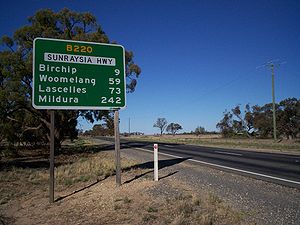
- BirchipBirchip, VictoriaBirchip is a town in the Mallee region of Victoria, Australia on the Sunraysia Highway north of Donald. The town is located in the Shire of Buloke Local Government Area. At the 2006 census Birchip had a population of 822...
- WoomelangWoomelang, VictoriaWoomelang is a town in the Mallee region of Victoria, Australia. The town is located on the Sunraysia Highway, kilometres north west of the state capital, Melbourne, kilometres south east of Mildura and kilometres north of Horsham...
- OuyenOuyen, VictoriaOuyen is a town in Victoria, Australia, located in the Rural City of Mildura at the junction of the Calder Highway and Mallee Highway, south of Mildura and north-west of Melbourne. At the 2006 census the town had a population of 1,061.-History:...
See also
- Highways in AustraliaHighways in AustraliaThis is a list of highways in Australia, listed alphabetically along with each highway's route number and location. Note that some highways service more than one state or territory.-Route numbering systems:...
- Highways in VictoriaHighways in VictoriaThe Highways in Victoria are the highest density in any state in Australia. Unlike Australia's other mainland states where vast areas are very sparsely inhabited "outback", there are population centres spread out over most of the state, with only the far north-west and the Victorian Alps lacking...