
Hume Highway
Encyclopedia
The Hume Highway/Hume Freeway is one of Australia's major inter-city highway
s, running for 880 km between Sydney
and Melbourne
. It is part of the Auslink National Network
and is a vital link for road freight to transport goods to and from the two cities as well as serving Albury
-Wodonga
and Canberra
.
The main alternative route between Sydney and Melbourne is the
 Princes Highway
which follows the coast for most of its length. Other inland alternate routes include the Olympic Highway route between Albury
and Sydney via Cowra
and Bathurst
, and also the Federal
/ Monaro Highway
route via Canberra
which links with the Hume Highway near Goulburn
and the Princes Highway in East Gippsland.
border to the Victoria
n border is separated from the inland by an escarpment
, forming the eastern edge of the Great Dividing Range
. There are few easy routes up this escarpment. To climb from the coast to the tablelands the Hume Highway uses the Bargo Ramp, a geological feature which provides one of the few easy crossings of the escarpment.
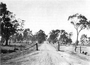
In the first twenty years of European settlement at Sydney (established 1788), exploration southwest of Sydney was slow. This area was heavily wooded at the time, especially the "Bargo brush
", which was regarded as almost impenetrable. In 1798 explorers (Wilson, Price, Hacking, and Collins) reached the Moss Vale
and Marulan
districts, but this was not followed up. Any settlement would have to await the construction of an adequate access track, which would have been beyond the colony's resources at the time, and would have served little purpose as a source of supplies for Sydney, due to the time taken to reach Sydney. In 1804, Charles Throsby
penetrated through the Bargo brush to the country on the tablelands near Moss Vale and Sutton Forest. On another expedition in 1818, he reached Lake Bathurst and the "Goulburn Plains"
. Many of the early explorers would most likely have used aboriginal guides, but they do not appear to have given them credit.
After Charles Throsby
's 1818 journey towards present day Goulburn, followed by Hamilton Hume and William Hovell's overland journey
from Appin (near Campbelltown) to Port Phillip and return in 1824, development of the Southern Tablelands for agriculture was rapid. The present route of the Hume Highway is much the same as that used by the pioneers.
The route taken by the Hume Highway to climb from the coast to the Southern Tablelands and thence across the Great Divide is situated between the parallel river gorge systems of the Wollondilly
and Shoalhaven River
s. This country consists generally of a gently sloping plateau which is deeply dissected by the Nepean River
and its tributaries. The route of the Highway, by using four high-level bridges to cross these gorges, avoids the Razorback Range, and has minimal earthworks. The climb from the western side of the Nepean River at Menangle
up to Mittagong
is fairly sustained, a fact that is hard to appreciate at high speed on the modern freeway. The highway climbs non-stop over a distance of 16 km from the Pheasant's Nest bridge over the Nepean River to Yerrinbool, before dropping slightly before the final climb to reach the tablelands at Aylmerton.
ordered the construction of a road, which became known as the Great South Road (the basis of the northern end of the Hume Highway) in 1819 from Picton to the Goulburn Plains and he travelled to Goulburn in 1820, but it is unlikely that even a primitive road was finished at that time.
 The Great South Road was rebuilt and completely re-routed between Yanderra
and Goulburn by Surveyor-General Thomas Mitchell in 1833. The Main Roads Management Act of June 1858 declared the Great Southern Road, from near Sydney through Goulburn and Gundagai to Albury, as one of the three main roads in the colony. However, its southern reaches were described as only a 'scarcely formed bullock track' as late as 1858. The road was improved in the mid 1860s with some sections near Gundagai "metalled" and all creeks bridged between Adelong Creek (approximately 10 kilometres south of Gundagai) and Albury.
Mitchell's route, except for the bypasses at Mittagong
, Berrima
and Marulan
(dual carriageways were completed in 1986) is still largely followed by the current highway. Mitchell intended to straighten the route north of Yanderra, but was not granted funding, although his proposed route through Pheasants Nest
has similarities to the freeway route opened in 1980. Mitchell's work on the Great South Road is best preserved at Towrang
Creek (10 kilometres north of Goulburn), where his stone arch culvert still stands, although it was superseded in 1965 by a concrete box culvert which in turn was superseded by the current route of the highway when it was duplicated in 1972.
In 1914 the NSW section of the highway was declared a main road. Until it was named the Hume Highway in 1928 it was known as the "Great South Road" in NSW and "Sydney Road" in Victoria. It was named after Hamilton Hume
, who with William Hovell
were the first Europeans to traverse an overland route between Sydney and Port Phillip, in what later became Victoria.
, in Summer Hill
. This route is numbered as . The first 35 km of the highway was known as Liverpool Road until August 1928, when it was renamed as part of the Hume or Great Southern Highway, as part of the creation of the NSW highway system. Sections of the highway through Sydney's suburbs continue to be also known by its former names of Liverpool Road, Sydney Road and Copeland Street (through Liverpool).
The main Hume Highway effectively commences at the junction of the M5 South Western Motorway
and the Westlink M7
at Casula
. Heading eastbound, the M5 provides access to Sydney Airport
and the CBD; while the M7 provides access to Newcastle
and Brisbane
bypassing the Sydney CBD. Both of these routes are tolled.
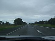
Other than sections within the urban areas of Sydney and Melbourne, the Hume Highway is dual carriageway
or freeway standard for its full length in Victoria, with three N.S.W. sections totalling 20 km, through the towns of Tarcutta, Holbrook and Woomargama. Projects to bypass these towns are presently at design stage, with construction envisaged to be completed by 2013.
Although (other than abovementioned three sections where town bypasses are proposed) the full length of the Hume Highway is dual carriageway (with at-grade intersections and restricted entry from adjoining land), there are considerable lengths of the highway which are of full freeway standard. Most of these sections are bypasses of the larger towns on the route, where the need to deviate the route to construct the bypass made it practical to deny access from adjoining land and thus provide full freeway conditions. In addition to these bypasses the sections between Casula (in southwestern Sydney) and Berrima (built 1973-92), and Broadford to Wallan (1976), which both were constructed as major deviations, are also of full freeway standard. The entire section in Victoria
is categorised as a freeway by government roads authority VicRoads
, although there a few intersections along the route that are not yet grade-separated. The speed limit on the full length of the highway, other than the three sections in New South Wales where bypasses are yet to be built, is 110 km/h.
As the Hume Freeway approaches Melbourne at the suburb of Craigieburn
, 27 km north of the city centre, the Craigieburn Bypass now diverts the Hume Freeway (and the M31 designation) to the east of the former route, to terminate at the Western Ring Road/Metropolitan Ring Road . This bypass was opened in two stages, in December 2004 and December 2005.
At its Melbourne end, the original alignment of the Melbourne-Sydney route followed Royal Parade northward from where it begins at its intersection with Elizabeth Street and Flemington Road. Royal Parade becomes Sydney Road at Brunswick Road and then became the Hume Highway itself at Campbellfield. This ceased to be the designated route of the Hume Highway in 1992, with the completion of Stage 1 of the Western Ring Road, at which point the designation of the southbound highway was truncated. The former highway south from the Western Ring Road to Elizabeth street is route is now numbered as , and is now officially called Sydney Road (Hume Highway).
is expected to be completed in 2010. The second stage, widening to 4 lanes each way between St Andrews Road and Raby Road commenced in 2009 and be completed in mid 2011. The final stage, widening to 3 lanes each way between Raby Road and Narellan Road, is scheduled to commence in late 2010 (following completion of the first stage) and be completed in late 2011. Construction of a pedestrian bridge over the highway to link Claymore
and Woodbine
is also underway. This section of the highway, opened as part of the two stages opened in October 1973 and December 1974, was originally designed for widening of the carriageways to three lanes.
Work commenced in 2009 on bypasses of Tarcutta and Woomargama, and in 2010 on a bypass of Holbrook. These three projects are scheduled to completion from 2013, and will result in dual carriageway (much to freeway standard) over the full length of the Hume Highway/Freeway.
_distances_updated.gif)
_distances.gif)
has undertaken a planning study for the upgrading of the Hume Freeway by removal of direct access from adjoining properties and grade-separation of the intersections between Kalkallo
and Beveridge
. These intersections have the highest accident rate of the Hume Freeway in Victoria. The study, completed in March 2009, intended to amend council planning schemes so as to reserve space for the upgrade, but no timetable has been set for the project.
In addition a 4-level interchange between the Hume Freeway and the Outer Metropolitan Ring Road
is proposed for construction after 2020.
, some of which is covered with box eucalypt forest but of which much is cleared for farmland, before levelling out near Seymour to cross flat, mostly cleared farming country to Wodonga and the Victoria-New South Wales border. Victoria's landscape differs to that of the typical 'true Australian Outback
', but a dry summer can leave the ground parched. Mount Buffalo
can be seen in the distance to the east as the highway comes down off the Warby Range near Glenrowan, and a museum commemorating Ned Kelly
is located nearby. At Wangaratta the highway passes close to the Rutherglen and Milawa wine-producing areas.
Continuing north, the Murray River
, the south bank of which is the Victoria-New South Wales border, is crossed on the bypass of Albury-Wodonga. From Albury, the highway skirts Lake Hume and continues across undulating country generally north-east towards Holbrook and then Tarcutta. Just north of Tarcutta the highway encounters the first of several ranges which form outliers of the Great Dividing Range, and which are crossed as the highway climbs the slopes to the tablelands west of Yass. From here the highway runs eastward, to Goulburn where it again turns northeast. Most of the New South Wales countryside from Albury to Marulan has been developed for wool
production, with Yass and Goulburn in particular noted for their fine wool.
and Albury. The speed limit on most of the dual carriageway length of the Hume Highway is 110 km/h, with the speed limit reduced to 50 km/h through Tarcutta and Holbrook, and to 70 km/h through Woomargama (the remaining three towns yet to be bypassed).
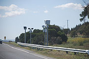
In January 2008, fixed speed-cameras were installed in the median strip along the Craigieburn Bypass and northward to Seymour
, in Victoria, at roughly 15–20 km intervals.
, Camden
, Picton
, Mittagong
, Berrima
, Marulan
, Goulburn
, Gunning
, Yass
, Bowning, Bookham
, Jugiong
, Coolac
, Gundagai
and Albury
. The three remaining towns on the Hume Highway yet to be bypassed are Tarcutta
, Woomargama
and Holbrook
, which are intended to be bypassed by 2012.
In Victoria; all towns have been bypassed. They are, in order from the NSW border, Wodonga
, Chiltern
, Wangaratta
, Benalla
, Euroa
, Violet Town
, Seymour
, Broadford
and Craigieburn
.
lies 60 km south west of Sydney on the Nepean River, and the town dates from 1840. It retains a rural character with many historic buildings of interest remaining. There is an aviation museum at nearby Narellan
. Urban sprawl has made Camden part of the Sydney metropolitan area.
The old route (pre-mid 1980s) of the Hume Highway runs straight west from the Cross Roads at Prestons
, 4 km south of Liverpool to Carnes Hill, where it joins the route of the Cowpasture Road. It then runs southwest to Camden (the section of the former highway from the Cross Roads to Camden is now called Camden Valley Way).
Camden has been bypassed by the Hume Highway twice. The first bypass was opened in 1973, via the Macarthur Bridge, and runs from Narellan to Benkennie (South Camden). This bypass was in turn bypassed in December 1980 when the section of what was then called the South Western Freeway (route F5) from Campbelltown to Yerrinbool was opened. This linked the freeway sections from the Cross Roads to Campbelltown Rd at St Andrews (opened August 1973) and St Andrews-Camden Road (opened December 1974) to its north with the section from Yerrinbool to Aylmerton (opened May 1977) to its south.
From Camden south to Aylmerton the former highway is now named Remembrance Drive. It climbs southwards from Camden through the Razorback Ridge to Picton, then begins to climb through Tahmoor and Bargo to reach the Southern Tablelands and rejoin the present route of the Hume Highway at Aylmerton, 6 km north of Mittagong. The designation Hume Highway and national route 31 were transferred from what are now Camden Valley Way and Remembrance Drive to the freeway route in the mid 1980s and the former highway route from the Cross Roads to Aylmerton is now state route 89.
 An alternative route to the highway runs from Aylmerton through Mittagong and Bowral to join the Illawarra Highway at Moss Vale and then follows the Illawarra Highway through Sutton Forest to rejoin the Hume Highway at Hoddles Crossroads (named after Surveyor Robert Hoddle who also laid out the Melbourne CBD).
lies 110 km south-west of Sydney, just off the Hume Highway at the edge of the Southern Tablelands. It is notable for being the location of Australia's first ironworks. Mittagong's streets are lined with various species of deciduous trees and it has a busy town centre.
Until 1992 when the Mittagong bypass was opened, the town was dominated by trucks and in winter it was also busy with skiers' traffic on the way to the Australian Alps. Today the Hume Highway bypasses Mittagong and all the towns of the Southern Tablelands. In the late 1990s, engineers detected subsidence under part of the bypass where it runs along a steep slope near the Nattai River. This was caused by features of the local geology, and mining activity at the adjacent Mount Alexandra coalmine from the 1950s to the 1970s. The problem was remedied by closing one carriageway at a time and building a pair of 'land bridges' across the unstable section of the slope.
is home to the famous Bradman Museum which not only celebrates the achievements of Bowral's favourite son, Sir Donald Bradman
, but also contains a wealth of world sporting information and memorabilia. Bowral is also the setting for "Tulip Time", a Spring celebration where over 100,000 tulips and 25,000 flowers are planted in the town centre.
The population swells during winter when, thousands of visitors book into local hotels and B&Bs
to enjoy romantic fires and secluded winter getaways. Spring is also very popular with gardening enthusiasts, who come to view some of the world's most beautiful formal gardens designed by eminent landscape architects such as Paul Sorensen
, who designed the gardens of Invergowrie.
Key attractions are the glorious gardens, fine restaurants, many successful vineyards and fresh, local produce of a wide variety. Antique and book stores abound, as do quality fashion retailers and specialty stores.
has several beautiful old and attractive buildings and Leighton Gardens, in the centre of the main street, is a pleasant park. It is best during spring when its flowers are in blossom or in autumn when the leaves of its exotic deciduous trees are changing colour.
 Sutton Forest is surrounded by farms, vineyards and is home to elegant country homes and estates. It comprises a church, and inn, a couple of restaurants and one or two specialty shops.
has flourished since it was bypassed in 1989, with tourists finding it an easy day trip from either Sydney or Canberra
to enjoy the town square and the Georgian architecture of this historic town.
bypass was opened in 1986. The southern part of Governor Lachlan Macquarie
's road of 1819 ran from Sutton Forest roughly along existing minor roads through what is now Penrose State Forest to Canyonleigh, Brayton, Carrick and Towrang, where it joined the current route to Goulburn. Branching from this route (now part of the Illawarra Highway
) just west of Sutton Forest, a road, now known as Old Argyle Road, developed in the 1820s. It ran to Bungonia
, via Wingello
, Tallong
, and the southern outskirts of Marulan.
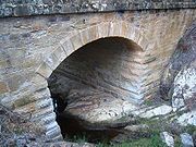
When Thomas Mitchell rerouted the Great South Road in the 1830s, he decided to bring these two roads together to meet at old Marulan, with roads proceeding west to Goulburn and south to Bungonia. When the railway reached Marulan in 1868, the town migrated 3 km north to the railway station. Nevertheless, the old cemetery remains at the Bungonia Road intersection. A quarry is about to be developed near the intersection, so an interchange is to be built. It is at this point that the highway climbs the Marulan Ramp, which is part of the divide between the Shoalhaven and Wollondilly River systems.
The stockade used to be accessible by a stile, but this has been taken down to discourage use of the once daunting intersection of the Highway with Towrang Road. There are the remains of the powder magazine next to the Wollondilly River
, three graves on the north bank of Towrang Creek, and the remains of a weir on Towrang Creek built for the stockade. Aboriginal stone tools have also been found on the banks of Towrang Creek, indicating that this was a route well-travelled long before Hamilton Hume
came this way in 1824.
There is also a rest area on the eastern side of the highway, where a well-preserved bridge dating from 1839 (possibly designed by David Lennox
) and a 1960s concrete box culvert can be viewed.
is the first city along the Hume Highway from Sydney. It is the centre of a rich agricultural area specialising in fine wool production. From this area comes some of the world's finest wool
. Goulburn was bypassed in 1992 and the main street (Auburn Street) is quieter, but still busy during Saturday morning shopping. Picturesque Belmore Park is located midway along Auburn Street. A number of architecturally and historically significant buildings are located near Belmore Park, including the courthouse, the post office and the railway station. Also in central Goulburn are two cathedrals, both of architectural note. A number of old houses and hotels are located near the railway station on Sloane Street.
19th century main street was built very wide, for the time of horse and bullock-drawn wagons. This served the town well when the main highway between Sydney and Melbourne carried cars and trucks through the town, which ceased when the bypass was completed in 1994. It is now much quieter, and the town has been able to resume a more rural pace of life and to develop something of an industry in providing bed and breakfast accommodation.
has an historic main street
, with well-preserved 19th century verandah-post pubs (mostly converted to other uses). It is popular with tourists, some from Canberra
and others taking a break from the Hume Highway. Hamilton Hume's farm Cooma Cottage is located east of Yass, close to the intersection of the former routes of the Hume and Barton Highways. He lived there until his death in 1873. Yass was bypassed in 1994.
is situated 29 km west of Yass. The Hume Highway once passed through the village, but now bypasses it.
It is a popular site for police speed traps, hence some wags have rechristened the town "Book 'em"
The grazing lands around the village of Bookham were originally called Bogolong and were much sought after by the early pioneers. Childhood memories of the races at the old Bogalong Racetrack inspired Banjo Paterson
to write his poem "Old Pardon the Son of Reprieve".
Bookham is the site of two very fine churches constructed from locally quarried granite
: the Uniting Church (c1926) and the Catholic Church, St Columbas (c1910). It also features an old-fashioned cricket field, resplendent with a white picket fence, the site of many a bush bash.
was the last two lane section of highway between Sydney and Gundagai until it was bypassed with a dual carriageway in August 2009., after a delay due to indigenous heritage issues, the construction contract was awarded to Abigroup Contractors Pty Ltd in February 2007.
". A statue (with souvenir shop next door) was erected five miles (eight kilometres) from Gundagai. Snake Gully serves as a way station for many highway travellers.
Gundagai
was bypassed in 1977 with the completion of the first Sheahan Bridge over the Murrumbidgee River
. This bridge was the second longest road bridge in New South Wales (the Sydney Harbour Bridge being the longest), until the completion of the duplicate Sheahan Bridge in May 2009, which is now the longest road bridge in New South Wales (1 m longer than the Sydney Harbour Bridge). The original Sheahan Bridge was only 1 lane in each direction.
The Prince Alfred Bridge, on the old route of the highway across the Murrumbidgee floodplain, is of major engineering interest, as it is one of Australia's longest timber trestle bridges, as is the adjacent 1903 railway bridge. Gundagai was originally located on the river flats directly beside the Murrumbidgee River, but a disastrous flood in 1852 destroyed the town and drowned 89 people. The town was then relocated to its present position. A grade-separated interchange was completed at the intersection of the Highway and West Street in 2006.
and rejoining the current route of the highway as Lower Tarcutta Road. This was replaced in December 1938 by the first Tumblong deviation, to the east of the current route. The main features of this section of the highway were a deep, narrow cutting and the reinforced concrete bowstring arch bridge over Hillas Creek. This bridge has been preserved as it is one of only two bridges in New South Wales built to this design, and is visible on the western side of the highway close to the interchange with the Snowy Mountains Highway
.
38 km southwest of Gundagai is the interchange with the Sturt Highway
, which leads to Wagga Wagga
, Mildura
and Adelaide
.
 Tarcutta
is located almost exactly halfway between Sydney and Melbourne and has been a popular stopover and change-over point for truck drivers making their way between the two cities. There is a memorial to truck drivers who have died on the local stretch of the Hume Highway.
With improvements to the Hume Highway which have reduced travelling time between Sydney and Melbourne to about nine hours driving time in good conditions, the town's importance to the average motorist has diminished. It was near Tarcutta that the final section of the Hume Highway was sealed in 1940. Tarcutta is scheduled to be bypassed in 2012.
was called Germanton until anti-German sentiment during World War 1 led to the town and the shire being renamed in honour of the wartime submarine captain, Lt Holbrook
who was awarded the Victoria Cross. From 1995, a feature of the town has been a partial reconstruction of HMAS Otway, an Oberon class submarine. This landmark was in recognition of the town's namesake's connections with submarines. In Holbrook is the only set of traffic signals (for pedestrians) remaining on the Hume Highway between the Sydney Orbital and Melbourne
's Western Ring Road. Like Tarcutta, Holbrook is scheduled to be bypassed in 2012.
, is a village between Holbrook and Albury which acts as a local service centre for a rich woolgrowing area. It is the third of the towns scheduled to be bypassed in 2012, thereby completing the duplication of the Hume Highway.
history is linked with the two famous Australian explorers, Hamilton Hume
and William Hovell
, as the city's location sprung from their crossing of the Murray River
. Albury, commonly associated with its Victorian twin, Wodonga
, is one of the few rural Australian cities to experience a boom, mainly from industrialisation in recent times. Albury-Wodonga is the largest centre on the Hume Highway, with a population of nearly 80,000.
The Albury bypass, built by Abigroup
, opened in January 2007, having been first proposed in 1964. Following a series of announcements and changes of plans through the 1990s, when Albury residents failed to agree on whether an 'internal' or 'external' bypass route was more appropriate, the 'internal bypass' option was chosen, with approval being granted in 2004 and construction commencing in January 2005. The route is parallel to and on the eastern side of the Sydney-Melbourne railway, beginning at the railway overpass 10 km north of Albury. After crossing the Murray River, the bypass route crosses the railway to rejoin the previous highway at the southern end of the Lincoln Causeway, connecting to the Wodonga bypass. The Albury bypass includes a freeway standard connection to the Murray Valley Highway at Bandiana, east of Wodonga.
 Wangaratta
is, after Wodonga, the largest centre in northeast Victoria (population 17,000). It is at the junction of the Hume and Ovens Highways (the 'Great Alpine Road'). Hume and Hovell passed through this area on their 1824 expedition and the town was founded in 1837 when the surrounding area was opened for farming.
The attractions around town include Merriwa Park, a sunken garden adjacent to the King River, Airworld at Wangaratta Airport, and old goldfield areas of nearby Beechworth
and Chiltern
.
 Benalla
is a large town located just off the Hume Freeway between Melbourne and Wangaratta. Founded in 1848, growth was slow until a goldrush in the 1850s. It had many associations with the Kelly gang and the courthouse was the venue for a number of their trials. It also has a memorial to the Australian war hero Sir Edward 'Weary' Dunlop
, an Australian doctor who acted as a leader to allied troops on the Thailand-Burma Railway in World War II
.
is famous for a Ned Kelly
bank robbery. The town is located on the Seven Creeks and has pretty gardens and a number of attractive 19th century buildings.
opened in December 1982. Seymour remains on the Goulburn Valley Highway
. The town is in the rich Goulburn Valley which supports the local vineyards. The large Puckapunyal
military base is located west of Seymour. Once the centre of the bushranging area of Victoria, it has a museum which displays many period relics of that era. It was until the 1970s a major railway maintenance centre, and part of the railway workshops now houses a railway museum. The museum's collection of rolling stock, including State carriages used by governors and monarchs, is extensive.
Road interchange, immediately to the north of the Craigieburn Bypass, replaced the dangerous at-grade intersection with (C723) at Kalkallo
an overpass and entry/exit ramps in both directions, at a cost of $32 million. Works commenced in December 2007 and completion occurred in March 2009, 3 months ahead of schedule.
 Prior to the opening of the Craigieburn
Bypass in 2005, the Hume Highway skirted Craigieburn (the town centre was bypassed in the 1950s). The section of the Highway from Craigieburn to Campbellfield (on Melbourne's outskirts) was a significant bottleneck, with 12 sets of traffic signals in 17 km section of road. The Craigieburn Bypass now links directly to the Western Ring Road/Metropolitan Ring Road.
There was some opposition for the bypass by several local governments in the northern suburbs of Melbourne
, including the City of Darebin
and the City of Moreland
, as well as local environmental groups. Their alternative proposal was rejected by the state government.
A pedestrian and cyclist cement path - the Galada Tamboore Pathway
- runs the length of the bypass and connects with the Metropolitan Ring Road path, from where it is possible to connect to the Merri Creek Trail
, Western Ring Road Trail
, the City of Whittlesea Public Gardens and Edgars Road.
The Craigieburn Bypass is shown in the 1969 Melbourne Transportation Plan
as part of the F2 Freeway corridor, which extended south along Merri Creek, Hoddle St, Barkly St in St. Kilda, south through Elwood and Brighton, then east along South Road, connecting to the Dingley Freeway corridor.
Highway
A highway is any public road. In American English, the term is common and almost always designates major roads. In British English, the term designates any road open to the public. Any interconnected set of highways can be variously referred to as a "highway system", a "highway network", or a...
s, running for 880 km between Sydney
Sydney
Sydney is the most populous city in Australia and the state capital of New South Wales. Sydney is located on Australia's south-east coast of the Tasman Sea. As of June 2010, the greater metropolitan area had an approximate population of 4.6 million people...
and Melbourne
Melbourne
Melbourne is the capital and most populous city in the state of Victoria, and the second most populous city in Australia. The Melbourne City Centre is the hub of the greater metropolitan area and the Census statistical division—of which "Melbourne" is the common name. As of June 2009, the greater...
. It is part of the Auslink National Network
National Highway (Australia)
thumb|right|150px|The National Highway Shield in NSW, QLD, WA, NT & TAS.The National Highway is a system of roads connecting all the States and Territories of Australia, and is the major network of highways connecting Australia's largest and most important cities.The National Highway was...
and is a vital link for road freight to transport goods to and from the two cities as well as serving Albury
Albury, New South Wales
Albury is a major regional city in New South Wales, Australia, located on the Hume Highway on the northern side of the Murray River. It is located wholly within the boundaries of the City of Albury Local Government Area...
-Wodonga
Wodonga, Victoria
Wodonga is a small city on the Victorian side of the border with New South Wales, north-east of Melbourne, Australia. Adjacent to Wodonga across the border is the New South Wales city of Albury. Wodonga is located wholly within the boundaries of the City of Wodonga LGA...
and Canberra
Canberra
Canberra is the capital city of Australia. With a population of over 345,000, it is Australia's largest inland city and the eighth-largest city overall. The city is located at the northern end of the Australian Capital Territory , south-west of Sydney, and north-east of Melbourne...
.
The main alternative route between Sydney and Melbourne is the
Princes HighwayPrinces Highway
The Princes Highway extends from Sydney to Port Augusta via the coast through the states of New South Wales, Victoria and South Australia, a distance of 1941 km or 1898 km via the former alignments of the highway ....
which follows the coast for most of its length. Other inland alternate routes include the
Olympic Highway route between AlburyAlbury, New South Wales
Albury is a major regional city in New South Wales, Australia, located on the Hume Highway on the northern side of the Murray River. It is located wholly within the boundaries of the City of Albury Local Government Area...
and Sydney via Cowra
Cowra, New South Wales
Cowra is a town in the Central West region of New South Wales, Australia in the Cowra Shire. It is located on the Mid-Western Highway, 317 kilometres west of Sydney on the banks of the Lachlan River at an altitude of 310 metres above sea level. At the 2006 census Cowra had a population of 8,430...
and Bathurst
Bathurst, New South Wales
-CBD and suburbs:Bathurst's CBD is located on William, George, Howick, Russell, and Durham Streets. The CBD is approximately 25 hectares and surrounds two city blocks. Within this block layout is banking, government services, shopping centres, retail shops, a park* and monuments...
, and also the
FederalFederal Highway
Federal Highways and Federal Routes can be found in:*Australia, National Highway 23 a short highway in New South Wales and the Australian Capital Territory is called the Federal Highway ....
/
Monaro HighwayMonaro Highway
The Monaro Highway is a state highway in New South Wales, the Australian Capital Territory and Victoria, Australia. The Victorian section was formerly known as the Cann Valley Highway until the 1980s....
route via Canberra
Canberra
Canberra is the capital city of Australia. With a population of over 345,000, it is Australia's largest inland city and the eighth-largest city overall. The city is located at the northern end of the Australian Capital Territory , south-west of Sydney, and north-east of Melbourne...
which links with the Hume Highway near Goulburn
Goulburn, New South Wales
Goulburn is a provincial city in the Southern Tablelands of New South Wales, Australia in Goulburn Mulwaree Council Local Government Area. It is located south-west of Sydney on the Hume Highway and above sea-level. On Census night 2006, Goulburn had a population of 20,127 people...
and the Princes Highway in East Gippsland.
History
The coast of New South Wales from the QueenslandQueensland
Queensland is a state of Australia, occupying the north-eastern section of the mainland continent. It is bordered by the Northern Territory, South Australia and New South Wales to the west, south-west and south respectively. To the east, Queensland is bordered by the Coral Sea and Pacific Ocean...
border to the Victoria
Victoria (Australia)
Victoria is the second most populous state in Australia. Geographically the smallest mainland state, Victoria is bordered by New South Wales, South Australia, and Tasmania on Boundary Islet to the north, west and south respectively....
n border is separated from the inland by an escarpment
Escarpment
An escarpment is a steep slope or long cliff that occurs from erosion or faulting and separates two relatively level areas of differing elevations.-Description and variants:...
, forming the eastern edge of the Great Dividing Range
Great Dividing Range
The Great Dividing Range, or the Eastern Highlands, is Australia's most substantial mountain range and the third longest in the world. The range stretches more than 3,500 km from Dauan Island off the northeastern tip of Queensland, running the entire length of the eastern coastline through...
. There are few easy routes up this escarpment. To climb from the coast to the tablelands the Hume Highway uses the Bargo Ramp, a geological feature which provides one of the few easy crossings of the escarpment.
In the first twenty years of European settlement at Sydney (established 1788), exploration southwest of Sydney was slow. This area was heavily wooded at the time, especially the "Bargo brush
Bargo, New South Wales
Bargo is a small town of the Macarthur Region, New South Wales, Australia in the Wollondilly Shire. It is approximately 100 km south west of Sydney....
", which was regarded as almost impenetrable. In 1798 explorers (Wilson, Price, Hacking, and Collins) reached the Moss Vale
Moss Vale, New South Wales
Moss Vale is a town in the Southern Highlands of New South Wales, Australia, in Wingecarribee Shire. It has a population of 7,339 and is sited on the Illawarra Highway, which connects to Wollongong and the Illawarra coast via Macquarie Pass...
and Marulan
Marulan, New South Wales
Marulan is a small town in the Southern Tablelands of New South Wales, Australia in the Goulburn Mulwaree Council Local Government Area. It is located south-west of Sydney on the Hume Highway, although it bypasses the town proper. Marulan lies on the 150th meridian east. It has a railway station...
districts, but this was not followed up. Any settlement would have to await the construction of an adequate access track, which would have been beyond the colony's resources at the time, and would have served little purpose as a source of supplies for Sydney, due to the time taken to reach Sydney. In 1804, Charles Throsby
Charles Throsby
Charles Throsby was an Australian explorer, pioneer and parliamentarian. He opened up much new land beyond the Blue Mountains for colonial settlement. He was a grazier, and became a prominent member of New South Wales society.- Early life :...
penetrated through the Bargo brush to the country on the tablelands near Moss Vale and Sutton Forest. On another expedition in 1818, he reached Lake Bathurst and the "Goulburn Plains"
Goulburn, New South Wales
Goulburn is a provincial city in the Southern Tablelands of New South Wales, Australia in Goulburn Mulwaree Council Local Government Area. It is located south-west of Sydney on the Hume Highway and above sea-level. On Census night 2006, Goulburn had a population of 20,127 people...
. Many of the early explorers would most likely have used aboriginal guides, but they do not appear to have given them credit.
After Charles Throsby
Charles Throsby
Charles Throsby was an Australian explorer, pioneer and parliamentarian. He opened up much new land beyond the Blue Mountains for colonial settlement. He was a grazier, and became a prominent member of New South Wales society.- Early life :...
's 1818 journey towards present day Goulburn, followed by Hamilton Hume and William Hovell's overland journey
Hume and Hovell expedition
The Hume and Hovell expedition was one of the most important journeys of explorations undertaken in eastern Australia. In 1824 the Governor of New South Wales, Sir Thomas Brisbane, commissioned Hamilton Hume and former Royal Navy Captain William Hovell to lead an expedition to find new grazing land...
from Appin (near Campbelltown) to Port Phillip and return in 1824, development of the Southern Tablelands for agriculture was rapid. The present route of the Hume Highway is much the same as that used by the pioneers.
The route taken by the Hume Highway to climb from the coast to the Southern Tablelands and thence across the Great Divide is situated between the parallel river gorge systems of the Wollondilly
Wollondilly River
The Wollondilly River is a perennial river in New South Wales, Australia. It was originally a tributary of the Warragamba River, and hence of the Nepean and Hawkesbury Rivers...
and Shoalhaven River
Shoalhaven River
The Shoalhaven River is a river rising from the Southern Tablelands and flowing into the ocean near Nowra on the South Coast of New South Wales, Australia.- History :...
s. This country consists generally of a gently sloping plateau which is deeply dissected by the Nepean River
Nepean River
The Nepean River is a river in the coastal region of New South Wales, Australia.The headwaters of the Nepean River rise near Robertson, about 100 kilometres south of Sydney and about 15 kilometres from the coast. The river flows north in an unpopulated water catchment area into Nepean Dam, which...
and its tributaries. The route of the Highway, by using four high-level bridges to cross these gorges, avoids the Razorback Range, and has minimal earthworks. The climb from the western side of the Nepean River at Menangle
Menangle, New South Wales
Menangle is a village in the Macarthur Region of New South Wales, Australia.-Location:Menangle is part of the Wollondilly Shire. At the 2006 census, Menangle had a population of 327 people.-History:...
up to Mittagong
Mittagong, New South Wales
Mittagong is a town located in the Southern Highlands of New South Wales, Australia, in Wingecarribee Shire. At the 2006 census, Mittagong had a population of 7,460 people. The town can be seen as the gateway to the Southern Highlands when coming from Sydney. The town is close to Bowral, Berrima,...
is fairly sustained, a fact that is hard to appreciate at high speed on the modern freeway. The highway climbs non-stop over a distance of 16 km from the Pheasant's Nest bridge over the Nepean River to Yerrinbool, before dropping slightly before the final climb to reach the tablelands at Aylmerton.
Early road construction
Governor Lachlan MacquarieLachlan Macquarie
Major-General Lachlan Macquarie CB , was a British military officer and colonial administrator. He served as the last autocratic Governor of New South Wales, Australia from 1810 to 1821 and had a leading role in the social, economic and architectural development of the colony...
ordered the construction of a road, which became known as the Great South Road (the basis of the northern end of the Hume Highway) in 1819 from Picton to the Goulburn Plains and he travelled to Goulburn in 1820, but it is unlikely that even a primitive road was finished at that time.
Yanderra, New South Wales
Yanderra is a small village situated on the border of the Southern Highlands and Macarthur Region of New South Wales, Australia. Yanderra is located between Bargo and Southern Highlands' Yerrinbool, and is located next to the Hume Highway. At the 2006 census, Yanderra had a population of 561...
and Goulburn by Surveyor-General Thomas Mitchell in 1833. The Main Roads Management Act of June 1858 declared the Great Southern Road, from near Sydney through Goulburn and Gundagai to Albury, as one of the three main roads in the colony. However, its southern reaches were described as only a 'scarcely formed bullock track' as late as 1858. The road was improved in the mid 1860s with some sections near Gundagai "metalled" and all creeks bridged between Adelong Creek (approximately 10 kilometres south of Gundagai) and Albury.
Mitchell's route, except for the bypasses at Mittagong
Mittagong, New South Wales
Mittagong is a town located in the Southern Highlands of New South Wales, Australia, in Wingecarribee Shire. At the 2006 census, Mittagong had a population of 7,460 people. The town can be seen as the gateway to the Southern Highlands when coming from Sydney. The town is close to Bowral, Berrima,...
, Berrima
Berrima, New South Wales
Berrima is an historic village in the Southern Highlands of New South Wales, Australia, in Wingecarribee Shire. The village, once a major town, is located on the Old Hume Highway between Canberra and Sydney. It was previously known officially as the Town of Berrima...
and Marulan
Marulan, New South Wales
Marulan is a small town in the Southern Tablelands of New South Wales, Australia in the Goulburn Mulwaree Council Local Government Area. It is located south-west of Sydney on the Hume Highway, although it bypasses the town proper. Marulan lies on the 150th meridian east. It has a railway station...
(dual carriageways were completed in 1986) is still largely followed by the current highway. Mitchell intended to straighten the route north of Yanderra, but was not granted funding, although his proposed route through Pheasants Nest
Pheasants Nest, New South Wales
Pheasants Nest is a small village in the Macarthur Region of New South Wales, Australia, in Wollondilly Shire. It has a north bound and south bound roadhouse on the Hume Highway...
has similarities to the freeway route opened in 1980. Mitchell's work on the Great South Road is best preserved at Towrang
Towrang, New South Wales
Towrang is a village in the Southern Tablelands of New South Wales, Australia, in Goulburn Mulwaree Council. It is approximately 13 km before Goulburn on the Hume Highway 180 km south from Sydney. At the 2006 census, Towrang and the surrounding area had a population of 406.The town was...
Creek (10 kilometres north of Goulburn), where his stone arch culvert still stands, although it was superseded in 1965 by a concrete box culvert which in turn was superseded by the current route of the highway when it was duplicated in 1972.
In 1914 the NSW section of the highway was declared a main road. Until it was named the Hume Highway in 1928 it was known as the "Great South Road" in NSW and "Sydney Road" in Victoria. It was named after Hamilton Hume
Hamilton Hume
Hamilton Hume was the first Australian born explorer. Along with Hovell in 1824, Hume was part of an expedition that first took an overland route from Sydney to Port Phillip near the site of present day Melbourne...
, who with William Hovell
William Hovell
William Hilton Hovell was an English explorer of Australia.-Early life:Hovell was born in Yarmouth, Norfolk, England and went to sea as a boy, becoming a Royal Navy captain before settling in New South Wales, arriving in October 1813 aboard the Earl Spencer with his wife Esther née Arndell...
were the first Europeans to traverse an overland route between Sydney and Port Phillip, in what later became Victoria.
Route
At its Sydney end, the Hume Highway begins at Parramatta RoadParramatta Road
.Parramatta Road is the major historical east-west artery of metropolitan Sydney, Australia, connecting the Sydney with Parramatta. It is the eastern-most part of the Great Western Highway. Much of its traffic has been diverted to modern expressways such as the M4 and the City West Link...
, in Summer Hill
Summer Hill, New South Wales
Summer Hill is a suburb of Sydney, in the state of New South Wales, Australia. Summer Hill is located 8 kilometres west of the Sydney central business district, in the local government area of the Municipality of Ashfield....
. This route is numbered as
. The first 35 km of the highway was known as Liverpool Road until August 1928, when it was renamed as part of the Hume or Great Southern Highway, as part of the creation of the NSW highway system. Sections of the highway through Sydney's suburbs continue to be also known by its former names of Liverpool Road, Sydney Road and Copeland Street (through Liverpool).The main Hume Highway effectively commences at the junction of the M5 South Western Motorway
M5 South Western Motorway
The M5 South Western Motorway is a privately operated tolled motorway in south-western Sydney, New South Wales, Australia. It forms part of Sydney Metroad 5 and the Sydney Orbital Network...
and the Westlink M7
Westlink M7
Westlink M7 - formerly Western Sydney Orbital - is one of Sydney, Australia's urban motorways and a part of Metroad 7 and the Sydney Orbital Network. It connects three Metroads: M5 at Prestons, M4 at Eastern Creek and M2 at Baulkham Hills...
at Casula
Casula, New South Wales
Casula is a suburb of Sydney in the state of New South Wales, Australia. Casula is located 35 kilometres south-west of the Sydney central business district, in the local government area of the City of Liverpool....
. Heading eastbound, the M5 provides access to Sydney Airport
Sydney Airport
Sydney Airport may refer to:* Sydney Airport, also known as Kingsford Smith International Airport, in Sydney, Australia* Sydney/J.A. Douglas McCurdy Airport, in Nova Scotia, Canada...
and the CBD; while the M7 provides access to Newcastle
Newcastle, New South Wales
The Newcastle metropolitan area is the second most populated area in the Australian state of New South Wales and includes most of the Newcastle and Lake Macquarie Local Government Areas...
and Brisbane
Brisbane
Brisbane is the capital and most populous city in the Australian state of Queensland and the third most populous city in Australia. Brisbane's metropolitan area has a population of over 2 million, and the South East Queensland urban conurbation, centred around Brisbane, encompasses a population of...
bypassing the Sydney CBD. Both of these routes are tolled.
Other than sections within the urban areas of Sydney and Melbourne, the Hume Highway is dual carriageway
Dual carriageway
A dual carriageway is a class of highway with two carriageways for traffic travelling in opposite directions separated by a central reservation...
or freeway standard for its full length in Victoria, with three N.S.W. sections totalling 20 km, through the towns of Tarcutta, Holbrook and Woomargama. Projects to bypass these towns are presently at design stage, with construction envisaged to be completed by 2013.
Although (other than abovementioned three sections where town bypasses are proposed) the full length of the Hume Highway is dual carriageway (with at-grade intersections and restricted entry from adjoining land), there are considerable lengths of the highway which are of full freeway standard. Most of these sections are bypasses of the larger towns on the route, where the need to deviate the route to construct the bypass made it practical to deny access from adjoining land and thus provide full freeway conditions. In addition to these bypasses the sections between Casula (in southwestern Sydney) and Berrima (built 1973-92), and Broadford to Wallan (1976), which both were constructed as major deviations, are also of full freeway standard. The entire section in Victoria
Victoria (Australia)
Victoria is the second most populous state in Australia. Geographically the smallest mainland state, Victoria is bordered by New South Wales, South Australia, and Tasmania on Boundary Islet to the north, west and south respectively....
is categorised as a freeway by government roads authority VicRoads
VicRoads
VicRoads or the Roads Corporation of Victoria is a statutory corporation which is the state road and traffic authority in the state of Victoria, Australia. It is responsible for maintenance and construction of the state arterial road network, as well as driver licensing and vehicle registration. ...
, although there a few intersections along the route that are not yet grade-separated. The speed limit on the full length of the highway, other than the three sections in New South Wales where bypasses are yet to be built, is 110 km/h.
As the Hume Freeway approaches Melbourne at the suburb of Craigieburn
Craigieburn, Victoria
Craigieburn is a suburb in Melbourne, Victoria, Australia, 26 km north from Melbourne's central business district. Its Local Government Area is the City of Hume. At the 2006 Census, Craigieburn had a population of 20,784....
, 27 km north of the city centre, the Craigieburn Bypass now diverts the Hume Freeway (and the M31 designation) to the east of the former route, to terminate at the Western Ring Road/Metropolitan Ring Road
. This bypass was opened in two stages, in December 2004 and December 2005.At its Melbourne end, the original alignment of the Melbourne-Sydney route followed Royal Parade northward from where it begins at its intersection with Elizabeth Street and Flemington Road. Royal Parade becomes Sydney Road at Brunswick Road and then became the Hume Highway itself at Campbellfield. This ceased to be the designated route of the Hume Highway in 1992, with the completion of Stage 1 of the Western Ring Road, at which point the designation of the southbound highway was truncated. The former highway south from the Western Ring Road to Elizabeth street is route is now numbered as
, and is now officially called Sydney Road (Hume Highway).Current New South Wales Upgrading
Work commenced in January 2009 to widen both carriageways between Brooks Road and Narellan Road. This work is being undertaken in 3 stages. The first stage, widening to 4 lanes each way between Brooks Road and St Andrews Road St AndrewsSt Andrews, New South Wales
St Andrews is a suburb of Sydney, in the state of New South Wales, Australia. St Andrews is located 55 kilometres south-west of the Sydney central business district, in the local government area of the City of Campbelltown and is part of the Macarthur region....
is expected to be completed in 2010. The second stage, widening to 4 lanes each way between St Andrews Road and Raby Road commenced in 2009 and be completed in mid 2011. The final stage, widening to 3 lanes each way between Raby Road and Narellan Road, is scheduled to commence in late 2010 (following completion of the first stage) and be completed in late 2011. Construction of a pedestrian bridge over the highway to link Claymore
Claymore, New South Wales
Claymore is a suburb of Sydney, in the state of New South Wales, Australia. Claymore is located 54 kilometres south-west of the Sydney central business district, in the local government area of the City of Campbelltown and is part of the Macarthur region. The majority of housing in Claymore is...
and Woodbine
Woodbine, New South Wales
Woodbine is a suburb of Sydney, in the state of New South Wales, Australia. Woodbine is located 55 kilometres south-west of the Sydney central business district, in the local government area of the City of Campbelltown and is part of the Macarthur region...
is also underway. This section of the highway, opened as part of the two stages opened in October 1973 and December 1974, was originally designed for widening of the carriageways to three lanes.
Work commenced in 2009 on bypasses of Tarcutta and Woomargama, and in 2010 on a bypass of Holbrook. These three projects are scheduled to completion from 2013, and will result in dual carriageway (much to freeway standard) over the full length of the Hume Highway/Freeway.
Current Victorian Upgrade Projects
VicRoadsVicRoads
VicRoads or the Roads Corporation of Victoria is a statutory corporation which is the state road and traffic authority in the state of Victoria, Australia. It is responsible for maintenance and construction of the state arterial road network, as well as driver licensing and vehicle registration. ...
has undertaken a planning study for the upgrading of the Hume Freeway by removal of direct access from adjoining properties and grade-separation of the intersections between Kalkallo
Kalkallo, Victoria
Kalkallo is a town in Victoria, Australia, 33 km north from Melbourne's central business district. Its Local Government Area is the City of Hume....
and Beveridge
Beveridge, Victoria
Beveridge is a town in Victoria, Australia, located along the Hume Highway, 42 kilometres north of Melbourne in the Shire of Mitchell. A western rural portion of the locality is within the City of Whittlesea in Greater Melbourne...
. These intersections have the highest accident rate of the Hume Freeway in Victoria. The study, completed in March 2009, intended to amend council planning schemes so as to reserve space for the upgrade, but no timetable has been set for the project.
In addition a 4-level interchange between the Hume Freeway and the Outer Metropolitan Ring Road
Outer Metropolitan Ring Road
The Outer Metropolitan Ring Road is a proposed freeway in Melbourne, Australia connecting the Hume Freeway at Kalkallo north of Melbourne, to the Princes Freeway south-west of Werribee...
is proposed for construction after 2020.
Views
Heading north from Melbourne, the road passes through the hills of the Great Dividing RangeGreat Dividing Range
The Great Dividing Range, or the Eastern Highlands, is Australia's most substantial mountain range and the third longest in the world. The range stretches more than 3,500 km from Dauan Island off the northeastern tip of Queensland, running the entire length of the eastern coastline through...
, some of which is covered with box eucalypt forest but of which much is cleared for farmland, before levelling out near Seymour to cross flat, mostly cleared farming country to Wodonga and the Victoria-New South Wales border. Victoria's landscape differs to that of the typical 'true Australian Outback
Outback
The Outback is the vast, remote, arid area of Australia, term colloquially can refer to any lands outside the main urban areas. The term "the outback" is generally used to refer to locations that are comparatively more remote than those areas named "the bush".-Overview:The outback is home to a...
', but a dry summer can leave the ground parched. Mount Buffalo
Mount Buffalo National Park
Mount Buffalo is a mountain plateau in Victoria , 200 km northeast of Melbourne. It is one of the oldest parks in the Australian Alps, being first established in 1898 when 1165 ha was reserved around Eurobin Falls...
can be seen in the distance to the east as the highway comes down off the Warby Range near Glenrowan, and a museum commemorating Ned Kelly
Ned Kelly
Edward "Ned" Kelly was an Irish Australian bushranger. He is considered by some to be merely a cold-blooded cop killer — others, however, consider him to be a folk hero and symbol of Irish Australian resistance against the Anglo-Australian ruling class.Kelly was born in Victoria to an Irish...
is located nearby. At Wangaratta the highway passes close to the Rutherglen and Milawa wine-producing areas.
Continuing north, the Murray River
Murray River
The Murray River is Australia's longest river. At in length, the Murray rises in the Australian Alps, draining the western side of Australia's highest mountains and, for most of its length, meanders across Australia's inland plains, forming the border between New South Wales and Victoria as it...
, the south bank of which is the Victoria-New South Wales border, is crossed on the bypass of Albury-Wodonga. From Albury, the highway skirts Lake Hume and continues across undulating country generally north-east towards Holbrook and then Tarcutta. Just north of Tarcutta the highway encounters the first of several ranges which form outliers of the Great Dividing Range, and which are crossed as the highway climbs the slopes to the tablelands west of Yass. From here the highway runs eastward, to Goulburn where it again turns northeast. Most of the New South Wales countryside from Albury to Marulan has been developed for wool
Wool
Wool is the textile fiber obtained from sheep and certain other animals, including cashmere from goats, mohair from goats, qiviut from muskoxen, vicuña, alpaca, camel from animals in the camel family, and angora from rabbits....
production, with Yass and Goulburn in particular noted for their fine wool.
Speed limits
Like most roads in Australia, the Hume Highway is speed-limited, although it was as recent as 1977 that speed limits were introduced on the section between the Federal HighwayFederal Highway
Federal Highways and Federal Routes can be found in:*Australia, National Highway 23 a short highway in New South Wales and the Australian Capital Territory is called the Federal Highway ....
and Albury. The speed limit on most of the dual carriageway length of the Hume Highway is 110 km/h, with the speed limit reduced to 50 km/h through Tarcutta and Holbrook, and to 70 km/h through Woomargama (the remaining three towns yet to be bypassed).
Fixed speed camera locations
In Sydney: next to Ashfield Primary School, near Culdees Road Burwood, Willee St Enfield, Brennan St Yagoona, and Knight St Lansvale.In January 2008, fixed speed-cameras were installed in the median strip along the Craigieburn Bypass and northward to Seymour
Seymour, Victoria
Seymour is a township in the Shire of Mitchell in the state of Victoria, Australia and is located north of Melbourne. At the 2006 census, Seymour had a population of 6,063...
, in Victoria, at roughly 15–20 km intervals.
Freeway section exits and major intersections
Hume Highway  Hume Freeway  South Western Freeway  |
|||
Northbound exits / intersections .svg.png) |
Distance to Sydney (km) |
Distance to Melbourne (km) |
Southbound exits / intersections |
| End South Western Freeway continues as South Western Motorway M5 South Western Motorway The M5 South Western Motorway is a privately operated tolled motorway in south-western Sydney, New South Wales, Australia. It forms part of Sydney Metroad 5 and the Sydney Orbital Network... to Bankstown Bankstown, New South Wales Bankstown is a suburb of south-western Sydney, in the state of New South Wales, Australia. Bankstown is located 20 kilometres south-west of the Sydney central business district and is the administrative centre of the local government area of the City of Bankstown.-History:Prior to European... / Sydney Sydney Sydney is the most populous city in Australia and the state capital of New South Wales. Sydney is located on Australia's south-east coast of the Tasman Sea. As of June 2010, the greater metropolitan area had an approximate population of 4.6 million people...  |
42 | 838 | Start South Western Freeway from South Western Motorway M5 South Western Motorway The M5 South Western Motorway is a privately operated tolled motorway in south-western Sydney, New South Wales, Australia. It forms part of Sydney Metroad 5 and the Sydney Orbital Network... and WestLink Westlink M7 Westlink M7 - formerly Western Sydney Orbital - is one of Sydney, Australia's urban motorways and a part of Metroad 7 and the Sydney Orbital Network. It connects three Metroads: M5 at Prestons, M4 at Eastern Creek and M2 at Baulkham Hills...  |
| Newcastle Newcastle, New South Wales The Newcastle metropolitan area is the second most populated area in the Australian state of New South Wales and includes most of the Newcastle and Lake Macquarie Local Government Areas... , Brisbane Brisbane Brisbane is the capital and most populous city in the Australian state of Queensland and the third most populous city in Australia. Brisbane's metropolitan area has a population of over 2 million, and the South East Queensland urban conurbation, centred around Brisbane, encompasses a population of... WestLink Westlink M7 Westlink M7 - formerly Western Sydney Orbital - is one of Sydney, Australia's urban motorways and a part of Metroad 7 and the Sydney Orbital Network. It connects three Metroads: M5 at Prestons, M4 at Eastern Creek and M2 at Baulkham Hills... |
|||
| Liverpool Liverpool, New South Wales Liverpool is a suburb in south-western Sydney, in the state of New South Wales, Australia. Liverpool is located 32 km south-west of the Sydney central business district, and is the administrative centre of the local government area of the City of Liverpool... Camden Valley Way Camden Valley Way Camden Valley Way is an important link between Sydney and the historic town of Camden.It is the former Hume Highway alignment between the localities of Cross Roads and Camden. It is marked as State Route 89. The proper route is from Cross Roads, skirting Camden via the Camden Bypass and ending at...  |
|||
| no exit | 47 | 833 | Ingleburn Ingleburn, New South Wales Ingleburn is a suburb of Sydney, in the state of New South Wales, Australia. Ingleburn is located 44 kilometres south-west of the Sydney central business district, in the local government area of City of Campbelltown and is part of the Macarthur region... Brooks Road |
| Denham Court Denham Court, New South Wales Denham Court is a suburb of Sydney, in the state of New South Wales, Australia. Denham Court is located 44 kilometres south-west of the Sydney central business district, in the local government areas of the City of Campbelltown and City of Liverpool. It is part of the Macarthur region.- History... , Ingleburn Ingleburn, New South Wales Ingleburn is a suburb of Sydney, in the state of New South Wales, Australia. Ingleburn is located 44 kilometres south-west of the Sydney central business district, in the local government area of City of Campbelltown and is part of the Macarthur region... Campbelltown Road  |
48 | 832 | no exit |
| no exit | 52 | 828 | Campbelltown Campbelltown, New South Wales Campbelltown is a suburb in south-western Sydney, in the state of New South Wales, Australia. Campbelltown is located 51 kilometres south-west of the Sydney central business district and is the administrative centre for the local government area of the City of Campbelltown.- History :Campbelltown... Campbelltown Road |
| End Hume Highway continues as South Western Freeway |
58 | 822 | Campbelltown Campbelltown, New South Wales Campbelltown is a suburb in south-western Sydney, in the state of New South Wales, Australia. Campbelltown is located 51 kilometres south-west of the Sydney central business district and is the administrative centre for the local government area of the City of Campbelltown.- History :Campbelltown... , Penrith Penrith, New South Wales Penrith is a suburb in western Sydney, in the state of New South Wales, Australia. Penrith is located west of the Sydney central business district and is the administrative centre for the local government area of the City of Penrith... Appin Road Appin Road Appin Road is a New South Wales secondary highway linking Campbelltown and the Sydney's western suburbs with Wollongong. It gets its name from Appin, which lies on its path and is the southern half of the State Route 69...  Narellan Road Metroad 9 Metroad 9 is one of Sydney, Australia's Metroads. It is the outer western Sydney Bypass connecting Campbelltown to Windsor.It replaced part of State Route 69 in December 1998 and consequently split State Route 69 into two sections. The northern section connects Windsor to Singleton...  |
| Camden Camden, New South Wales -Education:Camden is the location of research facilities for the veterinary and agricultural schools of the University of Sydney. The local government area has two public high schools, Camden High School and Elderslie High School, as well as eight Catholic and three Anglican schools.-Culture:The... , Campbelltown Campbelltown, New South Wales Campbelltown is a suburb in south-western Sydney, in the state of New South Wales, Australia. Campbelltown is located 51 kilometres south-west of the Sydney central business district and is the administrative centre for the local government area of the City of Campbelltown.- History :Campbelltown... , Bulli Bulli, New South Wales Bulli is a northern suburb of Wollongong situated on the south coast of New South Wales, Australia. Bulli is derived from an Aboriginal word signifying "double or two mountains".... Narellan Road Metroad 9 Metroad 9 is one of Sydney, Australia's Metroads. It is the outer western Sydney Bypass connecting Campbelltown to Windsor.It replaced part of State Route 69 in December 1998 and consequently split State Route 69 into two sections. The northern section connects Windsor to Singleton... Appin Road Appin Road Appin Road is a New South Wales secondary highway linking Campbelltown and the Sydney's western suburbs with Wollongong. It gets its name from Appin, which lies on its path and is the southern half of the State Route 69... |
Start Hume Highway from South Western Freeway |
||
| Picton Picton, New South Wales Picton is a small town in the Macarthur Region of New South Wales, Australia, in the Wollondilly Shire. The town is located 80 kilometres South-west of Sydney, close to Camden and Campbelltown. It is also the administrative centre of Wollondilly Shire.... , Wollongong Wollongong, New South Wales Wollongong is a seaside city located in the Illawarra region of New South Wales, Australia. It lies on the narrow coastal strip between the Illawarra Escarpment and the Pacific Ocean, 82 kilometres south of Sydney... Picton Road Picton Road Picton Road is a New South Wales highway linking Picton and Wollongong. It provides an important link between the Hume and Southern freeways. From Picton, the highway runs in the southeastern direction, crosses the Hume Highway and continues over grass-forested ranges east of Wilton until it meets...  |
80 | 800 | Picton Picton, New South Wales Picton is a small town in the Macarthur Region of New South Wales, Australia, in the Wollondilly Shire. The town is located 80 kilometres South-west of Sydney, close to Camden and Campbelltown. It is also the administrative centre of Wollondilly Shire.... , Wollongong Wollongong, New South Wales Wollongong is a seaside city located in the Illawarra region of New South Wales, Australia. It lies on the narrow coastal strip between the Illawarra Escarpment and the Pacific Ocean, 82 kilometres south of Sydney... Picton Road Picton Road Picton Road is a New South Wales highway linking Picton and Wollongong. It provides an important link between the Hume and Southern freeways. From Picton, the highway runs in the southeastern direction, crosses the Hume Highway and continues over grass-forested ranges east of Wilton until it meets... |
| Bargo Bargo, New South Wales Bargo is a small town of the Macarthur Region, New South Wales, Australia in the Wollondilly Shire. It is approximately 100 km south west of Sydney.... , Picton Picton, New South Wales Picton is a small town in the Macarthur Region of New South Wales, Australia, in the Wollondilly Shire. The town is located 80 kilometres South-west of Sydney, close to Camden and Campbelltown. It is also the administrative centre of Wollondilly Shire.... Remembrance Drive / Old Hume Highway Old Hume Highway The Old Hume Highway may be described as any part of an earlier route of the Hume Highway, which traverses Victoria and New South Wales between the cities of Melbourne and Sydney in Australia... |
92 | 788 | Bargo Bargo, New South Wales Bargo is a small town of the Macarthur Region, New South Wales, Australia in the Wollondilly Shire. It is approximately 100 km south west of Sydney.... Avon Dam Road |
| Colo Vale Colo Vale, New South Wales Colo Vale is a Northern Village of the Southern Highlands of New South Wales, Australia, in Wingecarribee Shire. It is situated 2 km north-west of Aylmerton, 5 km from the Hume Highway and 12 km drive to Mittagong.... , Yerrinbool Yerrinbool, New South Wales Yerrinbool is a Northern Village of the Southern Highlands of New South Wales, Australia, in the Wingecarribee Shire, and is accessible from the Hume Highway and is about 12 km drive from nearby Mittagong. It is 6–8 km by foot to Hill Top as the crow flies. It was previously officially... Church Avenue / Old Hume Highway Old Hume Highway The Old Hume Highway may be described as any part of an earlier route of the Hume Highway, which traverses Victoria and New South Wales between the cities of Melbourne and Sydney in Australia... |
105 | 775 | Yerrinbool Yerrinbool, New South Wales Yerrinbool is a Northern Village of the Southern Highlands of New South Wales, Australia, in the Wingecarribee Shire, and is accessible from the Hume Highway and is about 12 km drive from nearby Mittagong. It is 6–8 km by foot to Hill Top as the crow flies. It was previously officially... , Colo Vale Colo Vale, New South Wales Colo Vale is a Northern Village of the Southern Highlands of New South Wales, Australia, in Wingecarribee Shire. It is situated 2 km north-west of Aylmerton, 5 km from the Hume Highway and 12 km drive to Mittagong.... Old Hume Highway Old Hume Highway The Old Hume Highway may be described as any part of an earlier route of the Hume Highway, which traverses Victoria and New South Wales between the cities of Melbourne and Sydney in Australia... / Church Avenue |
| no exit | 107 | 773 | Mittagong Mittagong, New South Wales Mittagong is a town located in the Southern Highlands of New South Wales, Australia, in Wingecarribee Shire. At the 2006 census, Mittagong had a population of 7,460 people. The town can be seen as the gateway to the Southern Highlands when coming from Sydney. The town is close to Bowral, Berrima,... , Bowral Bowral, New South Wales -Attractions:Bowral is perhaps the best known of the towns and villages of the Southern Highlands, and in recent years has become the commercial centre of the Wingecarribee Shire. Bowral is known for its boutiques, antique stores, gourmet restaurants, and rich coffee culture.Bowral is home to the... Old Hume Highway Old Hume Highway The Old Hume Highway may be described as any part of an earlier route of the Hume Highway, which traverses Victoria and New South Wales between the cities of Melbourne and Sydney in Australia...  |
| Richlands, Mittagong Mittagong, New South Wales Mittagong is a town located in the Southern Highlands of New South Wales, Australia, in Wingecarribee Shire. At the 2006 census, Mittagong had a population of 7,460 people. The town can be seen as the gateway to the Southern Highlands when coming from Sydney. The town is close to Bowral, Berrima,... , Bowral Bowral, New South Wales -Attractions:Bowral is perhaps the best known of the towns and villages of the Southern Highlands, and in recent years has become the commercial centre of the Wingecarribee Shire. Bowral is known for its boutiques, antique stores, gourmet restaurants, and rich coffee culture.Bowral is home to the... Wombeyan Caves Road Wombeyan Caves Road The Wombeyan Caves Road is a New South Wales country road linking Mittagong near the Hume Highway in the east to the Goulburn-Oberon Road at the locality of Richlands in the west. The road is designated as Main Road 258.-Route:... / Old Hume Highway Old Hume Highway The Old Hume Highway may be described as any part of an earlier route of the Hume Highway, which traverses Victoria and New South Wales between the cities of Melbourne and Sydney in Australia... |
115 | 765 | no exit |
| Start Freeway | 128 | 752 | Berrima Berrima, New South Wales Berrima is an historic village in the Southern Highlands of New South Wales, Australia, in Wingecarribee Shire. The village, once a major town, is located on the Old Hume Highway between Canberra and Sydney. It was previously known officially as the Town of Berrima... , Medway Medway, New South Wales Medway is a small town in the Southern Highlands of New South Wales, Australia, in Wingecarribee Shire. It was formerly known as Village of Medway.... Medway Road |
| Berrima Berrima, New South Wales Berrima is an historic village in the Southern Highlands of New South Wales, Australia, in Wingecarribee Shire. The village, once a major town, is located on the Old Hume Highway between Canberra and Sydney. It was previously known officially as the Town of Berrima... Mereworth Road / Old Hume Highway Old Hume Highway The Old Hume Highway may be described as any part of an earlier route of the Hume Highway, which traverses Victoria and New South Wales between the cities of Melbourne and Sydney in Australia... |
End Freeway | ||
| Moss Vale Moss Vale, New South Wales Moss Vale is a town in the Southern Highlands of New South Wales, Australia, in Wingecarribee Shire. It has a population of 7,339 and is sited on the Illawarra Highway, which connects to Wollongong and the Illawarra coast via Macquarie Pass... , Wollongong Wollongong, New South Wales Wollongong is a seaside city located in the Illawarra region of New South Wales, Australia. It lies on the narrow coastal strip between the Illawarra Escarpment and the Pacific Ocean, 82 kilometres south of Sydney... Illawarra Highway Illawarra Highway Illawarra Highway connects Wollongong to NSW Southern Highlands. It links Princes Highway and Hume Highway and signed as National Route 48.It is named after the geographical area it crosses, the Illawarra region...  |
139 | 741 | Moss Vale Moss Vale, New South Wales Moss Vale is a town in the Southern Highlands of New South Wales, Australia, in Wingecarribee Shire. It has a population of 7,339 and is sited on the Illawarra Highway, which connects to Wollongong and the Illawarra coast via Macquarie Pass... , Canyonleigh Canyonleigh, New South Wales Canyonleigh is a small town in the Southern Highlands of New South Wales, Australia, in Wingecarribee Shire. In 2006, the town had a population of 292 people. Canyan Leigh was named by Mrs Jane Murray who took up a property between Paddys River and Long Swamp... Illawarra Highway Illawarra Highway Illawarra Highway connects Wollongong to NSW Southern Highlands. It links Princes Highway and Hume Highway and signed as National Route 48.It is named after the geographical area it crosses, the Illawarra region... |
| Exeter, Bundanoon Bundanoon, New South Wales Bundanoon is a town in the Southern Highlands of New South Wales, Australia, in Wingecarribee Shire. In 2006, Bundanoon had a population of 2,035 people... , Service Centre Sallys Corner Road |
142 | 738 | Exeter, Bundanoon Bundanoon, New South Wales Bundanoon is a town in the Southern Highlands of New South Wales, Australia, in Wingecarribee Shire. In 2006, Bundanoon had a population of 2,035 people... , Service Centre Sallys Corner Road |
| Heavy vehicle checking station | 166 | 714 | Marulan Marulan, New South Wales Marulan is a small town in the Southern Tablelands of New South Wales, Australia in the Goulburn Mulwaree Council Local Government Area. It is located south-west of Sydney on the Hume Highway, although it bypasses the town proper. Marulan lies on the 150th meridian east. It has a railway station... , Heavy vehicle checking station George Street |
| Marulan Marulan, New South Wales Marulan is a small town in the Southern Tablelands of New South Wales, Australia in the Goulburn Mulwaree Council Local Government Area. It is located south-west of Sydney on the Hume Highway, although it bypasses the town proper. Marulan lies on the 150th meridian east. It has a railway station... , Service Centre George Street |
167 | 713 | Service Centre |
| Goulburn Goulburn, New South Wales Goulburn is a provincial city in the Southern Tablelands of New South Wales, Australia in Goulburn Mulwaree Council Local Government Area. It is located south-west of Sydney on the Hume Highway and above sea-level. On Census night 2006, Goulburn had a population of 20,127 people... Sydney Road Old Hume Highway The Old Hume Highway may be described as any part of an earlier route of the Hume Highway, which traverses Victoria and New South Wales between the cities of Melbourne and Sydney in Australia... |
190 | 690 | Goulburn Goulburn, New South Wales Goulburn is a provincial city in the Southern Tablelands of New South Wales, Australia in Goulburn Mulwaree Council Local Government Area. It is located south-west of Sydney on the Hume Highway and above sea-level. On Census night 2006, Goulburn had a population of 20,127 people... Sydney Road Old Hume Highway The Old Hume Highway may be described as any part of an earlier route of the Hume Highway, which traverses Victoria and New South Wales between the cities of Melbourne and Sydney in Australia... |
| Goulburn Goulburn, New South Wales Goulburn is a provincial city in the Southern Tablelands of New South Wales, Australia in Goulburn Mulwaree Council Local Government Area. It is located south-west of Sydney on the Hume Highway and above sea-level. On Census night 2006, Goulburn had a population of 20,127 people... Hume Street Old Hume Highway The Old Hume Highway may be described as any part of an earlier route of the Hume Highway, which traverses Victoria and New South Wales between the cities of Melbourne and Sydney in Australia... |
200 | 680 | Goulburn Goulburn, New South Wales Goulburn is a provincial city in the Southern Tablelands of New South Wales, Australia in Goulburn Mulwaree Council Local Government Area. It is located south-west of Sydney on the Hume Highway and above sea-level. On Census night 2006, Goulburn had a population of 20,127 people... Hume Street Old Hume Highway The Old Hume Highway may be described as any part of an earlier route of the Hume Highway, which traverses Victoria and New South Wales between the cities of Melbourne and Sydney in Australia... |
| Canberra Canberra Canberra is the capital city of Australia. With a population of over 345,000, it is Australia's largest inland city and the eighth-largest city overall. The city is located at the northern end of the Australian Capital Territory , south-west of Sydney, and north-east of Melbourne... , Queanbeyan Queanbeyan, New South Wales Queanbeyan is a regional centre in the Southern Tablelands in south-eastern New South Wales adjacent to the Australian Capital Territory. The city's mixed economy is based on light construction, high technology, manufacturing, service, retail and agriculture. It is the council seat of the... , Cooma Cooma, New South Wales -Education: is Cooma's only public high school, it serves the town and seven of the neighbouring rural towns and villages such as Berridale, Jindabyne, Nimmitabel, Bredbo and Dalgety.... via U-turn |
208 | 672 | Barkers Lane |
| no exit | 209 | 671 | Canberra Canberra Canberra is the capital city of Australia. With a population of over 345,000, it is Australia's largest inland city and the eighth-largest city overall. The city is located at the northern end of the Australian Capital Territory , south-west of Sydney, and north-east of Melbourne... , Queanbeyan Queanbeyan, New South Wales Queanbeyan is a regional centre in the Southern Tablelands in south-eastern New South Wales adjacent to the Australian Capital Territory. The city's mixed economy is based on light construction, high technology, manufacturing, service, retail and agriculture. It is the council seat of the... , Cooma Cooma, New South Wales -Education: is Cooma's only public high school, it serves the town and seven of the neighbouring rural towns and villages such as Berridale, Jindabyne, Nimmitabel, Bredbo and Dalgety.... Federal Highway Federal Highway (Australia) The Federal Highway is a short highway in New South Wales and the Australian Capital Territory in Australia. It is a part of the Sydney-Canberra National Highway link.... |
| Breadalbane Breadalbane, New South Wales Breadalbane is a small village located in the Southern Tablelands of New South Wales, Australia in Upper Lachlan Shire. It is located on the Lachlan River headwaters and not far from Goulburn. This little town is also located nearby and adjacent to the major Hume Highway which links Sydney to... Cullerin Road Old Hume Highway The Old Hume Highway may be described as any part of an earlier route of the Hume Highway, which traverses Victoria and New South Wales between the cities of Melbourne and Sydney in Australia... |
219 | 661 | Breadalbane Breadalbane, New South Wales Breadalbane is a small village located in the Southern Tablelands of New South Wales, Australia in Upper Lachlan Shire. It is located on the Lachlan River headwaters and not far from Goulburn. This little town is also located nearby and adjacent to the major Hume Highway which links Sydney to... Cullerin Road Old Hume Highway The Old Hume Highway may be described as any part of an earlier route of the Hume Highway, which traverses Victoria and New South Wales between the cities of Melbourne and Sydney in Australia... |
| Gunning Gunning, New South Wales Gunning is a town on the Old Hume Highway, between Goulburn and Yass in the Southern Tablelands of New South Wales, Australia, about 260 km south-west of Sydney and 75 km north of the national capital, Canberra. On Census night 2006, Gunning had a population of 487 people... , Gundaroo Gundaroo, New South Wales Gundaroo is a small village in the Southern Tablelands of New South Wales, Australia and in Yass Valley Council. It is situated to the east of the Yass River, about north of Sutton, about west of the Lake George range. At the 2006 census, Gundaroo had a population of 331.The explorers Charles... Gundaroo Road |
242 | 638 | Gunning Gunning, New South Wales Gunning is a town on the Old Hume Highway, between Goulburn and Yass in the Southern Tablelands of New South Wales, Australia, about 260 km south-west of Sydney and 75 km north of the national capital, Canberra. On Census night 2006, Gunning had a population of 487 people... , Collector Collector, New South Wales Collector is a small village on the Federal Highway in New South Wales, Australia halfway between Goulburn and the Australian Capital Territory. It is seven kilometres north of Lake George... Gunning-Collector Road |
| Yass Yass, New South Wales Yass is a town in the Southern Tablelands of New South Wales, Australia in Yass Valley Shire. The name appears to have been derived from an Aboriginal word, "Yarrh" , said to mean 'running water'.... , Canberra Canberra Canberra is the capital city of Australia. With a population of over 345,000, it is Australia's largest inland city and the eighth-largest city overall. The city is located at the northern end of the Australian Capital Territory , south-west of Sydney, and north-east of Melbourne... , Queanbeyan Queanbeyan, New South Wales Queanbeyan is a regional centre in the Southern Tablelands in south-eastern New South Wales adjacent to the Australian Capital Territory. The city's mixed economy is based on light construction, high technology, manufacturing, service, retail and agriculture. It is the council seat of the... Barton Highway Barton Highway The Barton Highway is a short highway in New South Wales and the Australian Capital Territory, Australia.The Barton Highway connects Canberra to the Hume Highway at Yass, and it is part of the route from Melbourne to Canberra....  |
272 | 608 | Yass Yass, New South Wales Yass is a town in the Southern Tablelands of New South Wales, Australia in Yass Valley Shire. The name appears to have been derived from an Aboriginal word, "Yarrh" , said to mean 'running water'.... , Canberra Canberra Canberra is the capital city of Australia. With a population of over 345,000, it is Australia's largest inland city and the eighth-largest city overall. The city is located at the northern end of the Australian Capital Territory , south-west of Sydney, and north-east of Melbourne... Barton Highway Barton Highway The Barton Highway is a short highway in New South Wales and the Australian Capital Territory, Australia.The Barton Highway connects Canberra to the Hume Highway at Yass, and it is part of the route from Melbourne to Canberra.... |
| Yass Yass, New South Wales Yass is a town in the Southern Tablelands of New South Wales, Australia in Yass Valley Shire. The name appears to have been derived from an Aboriginal word, "Yarrh" , said to mean 'running water'.... , Service Centre Yass Valley Way Yass Valley Way Yass Valley Way is the main road which links Yass, New South Wales and Hume Highway and Barton Highway . The road is about 18 km long and runs parallel to the Yass River. It was created when the Hume Highway bypass of Yass was built in the early 1990s... |
281 | 599 | Yass Yass, New South Wales Yass is a town in the Southern Tablelands of New South Wales, Australia in Yass Valley Shire. The name appears to have been derived from an Aboriginal word, "Yarrh" , said to mean 'running water'.... , Service Centre Yass Valley Way Yass Valley Way Yass Valley Way is the main road which links Yass, New South Wales and Hume Highway and Barton Highway . The road is about 18 km long and runs parallel to the Yass River. It was created when the Hume Highway bypass of Yass was built in the early 1990s... |
| Boorowa Boorowa, New South Wales Boorowa is a farming town in the South West Slopes of New South Wales, Australia. At the 2006 census, Boorowa had a population of 1,070 people. It is located in a valley 243 km west of Sydney and 487 m above sea-level... , Cowra Cowra, New South Wales Cowra is a town in the Central West region of New South Wales, Australia in the Cowra Shire. It is located on the Mid-Western Highway, 317 kilometres west of Sydney on the banks of the Lachlan River at an altitude of 310 metres above sea level. At the 2006 census Cowra had a population of 8,430... Lachlan Valley Way Lachlan Valley Way Lachlan Valley Way is a New South Wales state highway running from Booligal on the Cobb Highway to north of Yass on the Hume Freeway.-References:**...  |
284 | 596 | Boorowa Boorowa, New South Wales Boorowa is a farming town in the South West Slopes of New South Wales, Australia. At the 2006 census, Boorowa had a population of 1,070 people. It is located in a valley 243 km west of Sydney and 487 m above sea-level... , Cowra Cowra, New South Wales Cowra is a town in the Central West region of New South Wales, Australia in the Cowra Shire. It is located on the Mid-Western Highway, 317 kilometres west of Sydney on the banks of the Lachlan River at an altitude of 310 metres above sea level. At the 2006 census Cowra had a population of 8,430... Lachlan Valley Way Lachlan Valley Way Lachlan Valley Way is a New South Wales state highway running from Booligal on the Cobb Highway to north of Yass on the Hume Freeway.-References:**... |
| Harden Harden, New South Wales Harden-Murrumburrah is a township and community in the centre of Harden Shire and is located in the South West Slopes region of New South Wales in Australia and is adjacent to both the Canberra region of the Australian Capital Territory and the Riverina Region in the southwest area of NSW... , Temora Temora, New South Wales Temora is a town located in north east part of the Riverina area of New South Wales, south-west of the state capital, Sydney. At the 2006 census the population of Temora was 4,086.-History:... Burley Griffin Way Burley Griffin Way Burley Griffin Way is a New South Wales state route, is located in south eastern Australia. Named after the American architect, Walter Burley Griffin, designer of the cities of Canberra and Griffith, the highway links the two cities via Yass and the Barton Highway.It provides a major link between...  |
293 | 587 | Harden Harden, New South Wales Harden-Murrumburrah is a township and community in the centre of Harden Shire and is located in the South West Slopes region of New South Wales in Australia and is adjacent to both the Canberra region of the Australian Capital Territory and the Riverina Region in the southwest area of NSW... , Temora Temora, New South Wales Temora is a town located in north east part of the Riverina area of New South Wales, south-west of the state capital, Sydney. At the 2006 census the population of Temora was 4,086.-History:... Burley Griffin Way Burley Griffin Way Burley Griffin Way is a New South Wales state route, is located in south eastern Australia. Named after the American architect, Walter Burley Griffin, designer of the cities of Canberra and Griffith, the highway links the two cities via Yass and the Barton Highway.It provides a major link between... |
| no exit | 334 | 546 | Jugiong Jugiong, New South Wales Jugiong is a village community on the banks of the Murrumbidgee River, in the central east part of the Riverina. It is situated just off the Hume Highway, by road, about 30 kilometres southwest from Bookham and 40 kilometres northeast from Gundagai... , Harden Harden, New South Wales Harden-Murrumburrah is a township and community in the centre of Harden Shire and is located in the South West Slopes region of New South Wales in Australia and is adjacent to both the Canberra region of the Australian Capital Territory and the Riverina Region in the southwest area of NSW... Riverside Drive Old Hume Highway The Old Hume Highway may be described as any part of an earlier route of the Hume Highway, which traverses Victoria and New South Wales between the cities of Melbourne and Sydney in Australia... |
| Murrumburrah Murrumburrah, New South Wales Murrumburrah is a township in New South Wales, Australia in Harden Shire and forms a twin town with Harden. It is near both the Canberra region of the Australian Capital Territory, and the Riverina Region in the southwest area of NSW. It is on the Burley Griffin Way, the major link from the... , Jugiong Jugiong, New South Wales Jugiong is a village community on the banks of the Murrumbidgee River, in the central east part of the Riverina. It is situated just off the Hume Highway, by road, about 30 kilometres southwest from Bookham and 40 kilometres northeast from Gundagai... Jugiong Road |
337 | 543 | no exit |
| no exit | 339 | 541 | Jugiong Jugiong, New South Wales Jugiong is a village community on the banks of the Murrumbidgee River, in the central east part of the Riverina. It is situated just off the Hume Highway, by road, about 30 kilometres southwest from Bookham and 40 kilometres northeast from Gundagai... Riverside Drive Old Hume Highway The Old Hume Highway may be described as any part of an earlier route of the Hume Highway, which traverses Victoria and New South Wales between the cities of Melbourne and Sydney in Australia... |
| Coolac Coolac, New South Wales Coolac is a village in the Riverina region of New South Wales, Australia in Gundagai Shire. At the 2006 census, Coolac had a population of 386 people.... , Cootamundra Cootamundra, New South Wales Cootamundra is a town and Local Government Area in the South West Slopes region of New South Wales, Australia and within the Riverina. At the 2006 census, Cootamundra had a population of 5,566. It is located on the Olympic Highway at the point where it crosses the Muttama Creek, between Junee and... Cootamundra Road |
357 | 523 | Coolac Coolac, New South Wales Coolac is a village in the Riverina region of New South Wales, Australia in Gundagai Shire. At the 2006 census, Coolac had a population of 386 people.... , Cootamundra Cootamundra, New South Wales Cootamundra is a town and Local Government Area in the South West Slopes region of New South Wales, Australia and within the Riverina. At the 2006 census, Cootamundra had a population of 5,566. It is located on the Olympic Highway at the point where it crosses the Muttama Creek, between Junee and... Cootamundra Road |
| Pettit Coleman Street |
361 | 519 | Pettit Gobarralong Road |
| Dog on the Tuckerbox Dog on the Tuckerbox The Dog on the Tuckerbox is an Australian historical monument and tourist attraction, located at Snake Gully, five miles from Gundagai, New South Wales... , Service Centre |
369 | 511 | Dog on the Tuckerbox Dog on the Tuckerbox The Dog on the Tuckerbox is an Australian historical monument and tourist attraction, located at Snake Gully, five miles from Gundagai, New South Wales... , Service Centre |
| no exit | 373 | 507 | Gundagai Gundagai, New South Wales Gundagai is a town in New South Wales, Australia. Although a small town, Gundagai is a popular topic for writers and has become a representative icon of a typical Australian country town... West Street |
| Gundagai Gundagai, New South Wales Gundagai is a town in New South Wales, Australia. Although a small town, Gundagai is a popular topic for writers and has become a representative icon of a typical Australian country town... Sheridan Street |
376 | 504 | Gundagai Gundagai, New South Wales Gundagai is a town in New South Wales, Australia. Although a small town, Gundagai is a popular topic for writers and has become a representative icon of a typical Australian country town... Sheridan Street |
| South Gundagai Gundagai, New South Wales Gundagai is a town in New South Wales, Australia. Although a small town, Gundagai is a popular topic for writers and has become a representative icon of a typical Australian country town... Cross Street |
378 | 502 | South Gundagai Gundagai, New South Wales Gundagai is a town in New South Wales, Australia. Although a small town, Gundagai is a popular topic for writers and has become a representative icon of a typical Australian country town... Middle Street |
| South Gundagai Gundagai, New South Wales Gundagai is a town in New South Wales, Australia. Although a small town, Gundagai is a popular topic for writers and has become a representative icon of a typical Australian country town... Mount Street |
|||
| Tumblong Tumblong, New South Wales Tumblong is a village community in the central east part of the Riverina and situated about 18 kilometres south east from Mundarlo and 25 kilometres north west from Adelong.-History:... Grahamstown Road |
389 | 491 | Tumblong Tumblong, New South Wales Tumblong is a village community in the central east part of the Riverina and situated about 18 kilometres south east from Mundarlo and 25 kilometres north west from Adelong.-History:... Grahamstown Road |
| Adelong Adelong, New South Wales Adelong is a small town in the Riverina region of New South Wales, Australia and is a part of the Tumut Shire. The Adelong district has a population of about 1400, while Adelong itself has a population of 829 people.... , Tumut Tumut, New South Wales Tumut is a town in the Riverina region of New South Wales, Australia, situated on the banks of the Tumut River. Tumut is at the foothills of the Snowy Mountains and is referred to as the gateway to the Snowy Mountains Scheme... , Cooma Cooma, New South Wales -Education: is Cooma's only public high school, it serves the town and seven of the neighbouring rural towns and villages such as Berridale, Jindabyne, Nimmitabel, Bredbo and Dalgety.... Snowy Mountains Highway Snowy Mountains Highway The Snowy Mountains Highway is a state highway in New South Wales, Australia which traverses the Snowy Mountains.The highway runs across the highland region in the southern part of the State. It starts at its junction with the Hume Highway near Gundagai...  |
403 | 477 | Adelong Adelong, New South Wales Adelong is a small town in the Riverina region of New South Wales, Australia and is a part of the Tumut Shire. The Adelong district has a population of about 1400, while Adelong itself has a population of 829 people.... , Tumut Tumut, New South Wales Tumut is a town in the Riverina region of New South Wales, Australia, situated on the banks of the Tumut River. Tumut is at the foothills of the Snowy Mountains and is referred to as the gateway to the Snowy Mountains Scheme... Snowy Mountains Highway Snowy Mountains Highway The Snowy Mountains Highway is a state highway in New South Wales, Australia which traverses the Snowy Mountains.The highway runs across the highland region in the southern part of the State. It starts at its junction with the Hume Highway near Gundagai... |
| Wagga Wagga Wagga Wagga, New South Wales Wagga Wagga is a city in New South Wales, Australia. Straddling the Murrumbidgee River, and with an urban population of 46,735 people, Wagga Wagga is the state's largest inland city, as well as an important agricultural, military, and transport hub of Australia... , Narrandera Narrandera, New South Wales -Transport:Narrandera is well served for transport. The Sturt Highway and the Newell Highways cross, just south of Narrandera. Greyhound buses pass daily - note that the destination can be listed as Jillenbah.... Sturt Highway Sturt Highway The Sturt Highway is an Australian highway in New South Wales, Victoria, and South Australia. It is part of the Auslink National network and is part of the main highway route between Sydney and Adelaide.-Route:...  |
413 | 467 | Wagga Wagga Wagga Wagga, New South Wales Wagga Wagga is a city in New South Wales, Australia. Straddling the Murrumbidgee River, and with an urban population of 46,735 people, Wagga Wagga is the state's largest inland city, as well as an important agricultural, military, and transport hub of Australia... , Narrandera Narrandera, New South Wales -Transport:Narrandera is well served for transport. The Sturt Highway and the Newell Highways cross, just south of Narrandera. Greyhound buses pass daily - note that the destination can be listed as Jillenbah.... , Mildura Mildura, Victoria Mildura is a regional city in northwestern Victoria, Australia and seat of the Rural City of Mildura local government area. It is located in the Sunraysia region, and is on the banks of the Murray River. The current population is estimated at just over 30,000.Mildura is a major agricultural centre... , Adelaide Adelaide Adelaide is the capital city of South Australia and the fifth-largest city in Australia. Adelaide has an estimated population of more than 1.2 million... Sturt Highway Sturt Highway The Sturt Highway is an Australian highway in New South Wales, Victoria, and South Australia. It is part of the Auslink National network and is part of the main highway route between Sydney and Adelaide.-Route:... |
| END SINGLE CARRIAGEWAY SECTION | 414 | 466 | START SINGLE CARRIAGEWAY SECTION Planned upgrade completion 2012 |
| Tarcutta Tarcutta, New South Wales Tarcutta is a small town located 438 km south-west of Sydney, three kilometres east of the Hume Highway, in New South Wales, Australia. It was proclaimed as a village on 28 October 1890... |
421 | 459 | Tarcutta Tarcutta, New South Wales Tarcutta is a small town located 438 km south-west of Sydney, three kilometres east of the Hume Highway, in New South Wales, Australia. It was proclaimed as a village on 28 October 1890... |
| Holbrook Holbrook, New South Wales Holbrook is a small town in Southern New South Wales, Australia. It is on the Hume Highway, 356 km North-East of Melbourne and 491 km south-west of Sydney between Tarcutta and Albury. The town is in the Greater Hume Shire Council area which was established in May 2004 from the merger of... |
491 | 389 | Holbrook Holbrook, New South Wales Holbrook is a small town in Southern New South Wales, Australia. It is on the Hume Highway, 356 km North-East of Melbourne and 491 km south-west of Sydney between Tarcutta and Albury. The town is in the Greater Hume Shire Council area which was established in May 2004 from the merger of... |
| Woomargama Woomargama, New South Wales Woomargama is a picturesque village community in the south east part of the Riverina, in the foothills of the great dividing range. It is situated by road, about north-east from Mullengandra and south-west from Holbrook... |
511 | 369 | Woomargama Woomargama, New South Wales Woomargama is a picturesque village community in the south east part of the Riverina, in the foothills of the great dividing range. It is situated by road, about north-east from Mullengandra and south-west from Holbrook... |
| START SINGLE CARRIAGEWAY SECTION Planned upgrade completion 2012 |
515 | 365 | END SINGLE CARRIAGEWAY SECTION |
| Culcairn Culcairn, New South Wales Culcairn is a town in the south east Riverina region of New South Wales, Australia. Culcairn is located in the Greater Hume Shire Council Local government area on the Olympic Highway between Albury and Wagga Wagga... , Wagga Wagga Wagga Wagga, New South Wales Wagga Wagga is a city in New South Wales, Australia. Straddling the Murrumbidgee River, and with an urban population of 46,735 people, Wagga Wagga is the state's largest inland city, as well as an important agricultural, military, and transport hub of Australia... , Cowra Cowra, New South Wales Cowra is a town in the Central West region of New South Wales, Australia in the Cowra Shire. It is located on the Mid-Western Highway, 317 kilometres west of Sydney on the banks of the Lachlan River at an altitude of 310 metres above sea level. At the 2006 census Cowra had a population of 8,430... Olympic Highway |
535 | 345 | Culcairn Culcairn, New South Wales Culcairn is a town in the south east Riverina region of New South Wales, Australia. Culcairn is located in the Greater Hume Shire Council Local government area on the Olympic Highway between Albury and Wagga Wagga... , Wagga Wagga Wagga Wagga, New South Wales Wagga Wagga is a city in New South Wales, Australia. Straddling the Murrumbidgee River, and with an urban population of 46,735 people, Wagga Wagga is the state's largest inland city, as well as an important agricultural, military, and transport hub of Australia... Olympic Highway |
| no exit | 544 | 336 | Ettamogah Table Top/Ettamogah, New South Wales Table Top is an outer suburb of the city of Albury, New South Wales, located north of Albury and west of Bowna. At the 2006 census, Table Top had a population of 1109.... , Jindera Jindera, New South Wales Jindera is a town in the southern Riverina region of New South Wales, Australia. The town is situated north of the regional centre of Albury, in the Greater Hume Shire Local government area... Wagga Road Old Hume Highway The Old Hume Highway may be described as any part of an earlier route of the Hume Highway, which traverses Victoria and New South Wales between the cities of Melbourne and Sydney in Australia... |
| Springdale Heights Springdale Heights, New South Wales Springdale Heights is a suburb of the city of Albury, New South Wales, located north of the Albury Central Business District and north of Lavington At the 2006 census, Springdale Heights had a population of 1761, although the area covered in the Census includes parts of Table Top.Springdale... , Thurgoona Thurgoona, New South Wales Thurgoona is an outer suburb of the regional city of Albury in southern New South Wales, Australia. The suburb is located in the City of Albury Local government area.It is the site of one of the campuses of Charles Sturt University... Thurgoona Drive |
549 | 331 | Thurgoona Thurgoona, New South Wales Thurgoona is an outer suburb of the regional city of Albury in southern New South Wales, Australia. The suburb is located in the City of Albury Local government area.It is the site of one of the campuses of Charles Sturt University... Thurgoona Drive |
| North Albury North Albury, New South Wales North Albury is a suburb of the city of Albury, New South Wales, located north of the Albury Central Business District. At the 2006 census, North Albury had a population of 6089.... , Wirlinga Dallinger Road |
551 | 329 | no exit |
| Albury Albury, New South Wales Albury is a major regional city in New South Wales, Australia, located on the Hume Highway on the northern side of the Murray River. It is located wholly within the boundaries of the City of Albury Local Government Area... , Lake Hume, Corowa Corowa, New South Wales Corowa is a town in the state of New South Wales in Australia. It is on the bank of the Murray River, the border between New South Wales and Victoria, opposite the Victorian town of Wahgunyah. Corowa is the administrative centre of Corowa Shire... Riverina Highway Riverina Highway Riverina Highway is a highway in New South Wales, Australia.Westwards, the highway stretches from Hume Weir, immediately east of Albury to Deniliquin...  |
555 | 325 | Lake Hume, Albury Albury, New South Wales Albury is a major regional city in New South Wales, Australia, located on the Hume Highway on the northern side of the Murray River. It is located wholly within the boundaries of the City of Albury Local Government Area... Riverina Highway Riverina Highway Riverina Highway is a highway in New South Wales, Australia.Westwards, the highway stretches from Hume Weir, immediately east of Albury to Deniliquin... |
| South Albury South Albury, New South Wales South Albury is a suburb of the city of Albury, New South Wales, located south of the Albury Central Business District. At the 2006 census, South Albury had a population of 1102.... Bridge Street |
556 | 324 | Albury Albury, New South Wales Albury is a major regional city in New South Wales, Australia, located on the Hume Highway on the northern side of the Murray River. It is located wholly within the boundaries of the City of Albury Local Government Area... Bridge Street |
| Start Hume Highway |
558 | 322 | End Hume Highway |
| MURRAY RIVER Murray River The Murray River is Australia's longest river. At in length, the Murray rises in the Australian Alps, draining the western side of Australia's highest mountains and, for most of its length, meanders across Australia's inland plains, forming the border between New South Wales and Victoria as it... |
MURRAY RIVER Murray River The Murray River is Australia's longest river. At in length, the Murray rises in the Australian Alps, draining the western side of Australia's highest mountains and, for most of its length, meanders across Australia's inland plains, forming the border between New South Wales and Victoria as it... |
||
| NEW SOUTH WALES STATE BORDER VICTORIA |
|||
| End Hume Freeway |
558 | 322 | Start Hume Freeway |
| no exit | 559 | 321 | Tallangatta Tallangatta, Victoria Tallangatta is a small town in north-eastern Victoria, Australia. At the 2006 census, Tallangatta had a population of 950.The town is situated on the banks of the Mitta Arm of Lake Hume, approximately south-east of Albury-Wodonga along the Murray Valley Highway.-History:Tallangatta was founded in... Bandiana Link  |
| continues as |
560 | 320 | Wodonga Wodonga, Victoria Wodonga is a small city on the Victorian side of the border with New South Wales, north-east of Melbourne, Australia. Adjacent to Wodonga across the border is the New South Wales city of Albury. Wodonga is located wholly within the boundaries of the City of Wodonga LGA... , Albury Albury, New South Wales Albury is a major regional city in New South Wales, Australia, located on the Hume Highway on the northern side of the Murray River. It is located wholly within the boundaries of the City of Albury Local Government Area... High Street Murray Valley Highway The Murray Valley Highway is a popular tourist route, which follows the south side of the Murray River in Victoria, Australia. The route effectively acts as the northern-most highway in Victoria...   Lincoln Causeway Old Hume Highway The Old Hume Highway may be described as any part of an earlier route of the Hume Highway, which traverses Victoria and New South Wales between the cities of Melbourne and Sydney in Australia... |
| Albury Albury, New South Wales Albury is a major regional city in New South Wales, Australia, located on the Hume Highway on the northern side of the Murray River. It is located wholly within the boundaries of the City of Albury Local Government Area... , Wodonga Wodonga, Victoria Wodonga is a small city on the Victorian side of the border with New South Wales, north-east of Melbourne, Australia. Adjacent to Wodonga across the border is the New South Wales city of Albury. Wodonga is located wholly within the boundaries of the City of Wodonga LGA... Lincoln Causeway Old Hume Highway The Old Hume Highway may be described as any part of an earlier route of the Hume Highway, which traverses Victoria and New South Wales between the cities of Melbourne and Sydney in Australia... High Street Murray Valley Highway The Murray Valley Highway is a popular tourist route, which follows the south side of the Murray River in Victoria, Australia. The route effectively acts as the northern-most highway in Victoria... |
continues as ' |
||
| no exit | 562 | 318 | Wodonga Wodonga, Victoria Wodonga is a small city on the Victorian side of the border with New South Wales, north-east of Melbourne, Australia. Adjacent to Wodonga across the border is the New South Wales city of Albury. Wodonga is located wholly within the boundaries of the City of Wodonga LGA... Melrose Drive / Moloney Drive |
| Wodonga Wodonga, Victoria Wodonga is a small city on the Victorian side of the border with New South Wales, north-east of Melbourne, Australia. Adjacent to Wodonga across the border is the New South Wales city of Albury. Wodonga is located wholly within the boundaries of the City of Wodonga LGA... Melbourne Road |
564 | 316 | no exit |
| continues as |
576 | 304 | Yarrawonga Yarrawonga, Victoria Yarrawonga is a town in the Shire of Moira Local Government Area in the Australian state of Victoria. The town is situated on the south bank of the Murray River, the border between Victoria and New South Wales and is located approximately north-east of the state capital, Melbourne. Yarrawonga's... , Echuca Echuca, Victoria Echuca is a town located on the banks of the Murray River and Campaspe river in Victoria, Australia. The Border town Moama is on the northern side of the Murray river in New South Wales. It is the administrative centre and largest settlement in the Shire of Campaspe... Murray Valley Highway Murray Valley Highway The Murray Valley Highway is a popular tourist route, which follows the south side of the Murray River in Victoria, Australia. The route effectively acts as the northern-most highway in Victoria... |
| Yarrawonga Yarrawonga, Victoria Yarrawonga is a town in the Shire of Moira Local Government Area in the Australian state of Victoria. The town is situated on the south bank of the Murray River, the border between Victoria and New South Wales and is located approximately north-east of the state capital, Melbourne. Yarrawonga's... , Echuca Echuca, Victoria Echuca is a town located on the banks of the Murray River and Campaspe river in Victoria, Australia. The Border town Moama is on the northern side of the Murray river in New South Wales. It is the administrative centre and largest settlement in the Shire of Campaspe... Murray Valley Highway Murray Valley Highway The Murray Valley Highway is a popular tourist route, which follows the south side of the Murray River in Victoria, Australia. The route effectively acts as the northern-most highway in Victoria... |
continues as |
||
| Barnawartha Barnawartha, Victoria Barnawartha is a small town located on the Hume Highway in regional north-east Victoria, Australia, approximately from Melbourne on the banks of Indigo Creek which runs into the Murray River to the north.... , Upper Indigo Indigo Creek Road |
582 | 298 | Barnawartha Barnawartha, Victoria Barnawartha is a small town located on the Hume Highway in regional north-east Victoria, Australia, approximately from Melbourne on the banks of Indigo Creek which runs into the Murray River to the north.... , Upper Indigo Indigo Creek Road |
| Chiltern Chiltern, Victoria Chiltern is a town in Victoria, Australia, located in the north east of the state between Wangaratta and Wodonga, in the Shire of Indigo. At the 2006 census, Chiltern had a population of 1063. The town is close to the Chiltern-Mount Pilot National Park... , Beechworth Beechworth, Victoria Beechworth is a well-preserved historical town located in the north-east of Victoria, Australia, famous for its major growth during the gold rush days of the mid-1850s... Chiltern-Howlong Road  / /Beechworth-Chiltern Road |
591 | 289 | Chiltern Chiltern, Victoria Chiltern is a town in Victoria, Australia, located in the north east of the state between Wangaratta and Wodonga, in the Shire of Indigo. At the 2006 census, Chiltern had a population of 1063. The town is close to the Chiltern-Mount Pilot National Park... , Beechworth Beechworth, Victoria Beechworth is a well-preserved historical town located in the north-east of Victoria, Australia, famous for its major growth during the gold rush days of the mid-1850s... Chiltern-Howlong Road /Beechworth-Chiltern Road |
| Springhurst, Rutherglen Rutherglen, Victoria Rutherglen is a small town in north-eastern Victoria, Australia, near the Murray River border with New South Wales. The town was named after the Scottish town of Rutherglen which lies just outside Glasgow... Rutherglen-Springhurst Road  |
603 | 277 | Springhurst, Rutherglen Rutherglen, Victoria Rutherglen is a small town in north-eastern Victoria, Australia, near the Murray River border with New South Wales. The town was named after the Scottish town of Rutherglen which lies just outside Glasgow... Rutherglen-Springhurst Road |
| Bowser, Wangaratta Wangaratta, Victoria Wangaratta is a cathedral city of almost 17,000 people in the northeast of Victoria, Australia, about from Melbourne along the Hume Highway, with Benalla to the southwest, and Albury-Wodonga to the northeast. It is located at the junction of the Ovens and King rivers which flow from the... Wangaratta Road Old Hume Highway The Old Hume Highway may be described as any part of an earlier route of the Hume Highway, which traverses Victoria and New South Wales between the cities of Melbourne and Sydney in Australia...  |
620 | 260 | Bowser, Wangaratta Wangaratta, Victoria Wangaratta is a cathedral city of almost 17,000 people in the northeast of Victoria, Australia, about from Melbourne along the Hume Highway, with Benalla to the southwest, and Albury-Wodonga to the northeast. It is located at the junction of the Ovens and King rivers which flow from the... Wangaratta Road Old Hume Highway The Old Hume Highway may be described as any part of an earlier route of the Hume Highway, which traverses Victoria and New South Wales between the cities of Melbourne and Sydney in Australia... |
| Wangaratta Wangaratta, Victoria Wangaratta is a cathedral city of almost 17,000 people in the northeast of Victoria, Australia, about from Melbourne along the Hume Highway, with Benalla to the southwest, and Albury-Wodonga to the northeast. It is located at the junction of the Ovens and King rivers which flow from the... , Beechworth Beechworth, Victoria Beechworth is a well-preserved historical town located in the north-east of Victoria, Australia, famous for its major growth during the gold rush days of the mid-1850s... , Bright Bright, Victoria Bright is a small sized town, located in northeastern Victoria, Australia, 319 metres above sea level at the southeastern end of the Ovens Valley. At the 2006 census, Bright had a population of 2684. It is in the Alpine Shire local government area... , Mount Hotham Mount Hotham Mount Hotham is a mountain in Victoria, Australia. It is home to Hotham Alpine Resort. The mountain is located approximately north east of Melbourne, from Sydney, and from Adelaide by road. Mt Hotham's summit rises to an altitude of above sea level... Great Alpine Road Great Alpine Road The Great Alpine Road is a country tourist road in Victoria, Australia, running from Wangaratta in the north to Bairnsdale in the east, and passing through the Australian Alps...  |
627 | 253 | Wangaratta Wangaratta, Victoria Wangaratta is a cathedral city of almost 17,000 people in the northeast of Victoria, Australia, about from Melbourne along the Hume Highway, with Benalla to the southwest, and Albury-Wodonga to the northeast. It is located at the junction of the Ovens and King rivers which flow from the... , Bright Bright, Victoria Bright is a small sized town, located in northeastern Victoria, Australia, 319 metres above sea level at the southeastern end of the Ovens Valley. At the 2006 census, Bright had a population of 2684. It is in the Alpine Shire local government area... , Mount Hotham Mount Hotham Mount Hotham is a mountain in Victoria, Australia. It is home to Hotham Alpine Resort. The mountain is located approximately north east of Melbourne, from Sydney, and from Adelaide by road. Mt Hotham's summit rises to an altitude of above sea level... Great Alpine Road Great Alpine Road The Great Alpine Road is a country tourist road in Victoria, Australia, running from Wangaratta in the north to Bairnsdale in the east, and passing through the Australian Alps... |
| Wangaratta Wangaratta, Victoria Wangaratta is a cathedral city of almost 17,000 people in the northeast of Victoria, Australia, about from Melbourne along the Hume Highway, with Benalla to the southwest, and Albury-Wodonga to the northeast. It is located at the junction of the Ovens and King rivers which flow from the... , Greta Greta, Victoria Greta is a district in Victoria, Australia, located east of Benalla, in the Rural City of Wangaratta. At the 2006 census, Greta and the surrounding area had a population of 231.-History:... Greta Road  |
635 | 245 | Wangaratta Wangaratta, Victoria Wangaratta is a cathedral city of almost 17,000 people in the northeast of Victoria, Australia, about from Melbourne along the Hume Highway, with Benalla to the southwest, and Albury-Wodonga to the northeast. It is located at the junction of the Ovens and King rivers which flow from the... , Greta Greta, Victoria Greta is a district in Victoria, Australia, located east of Benalla, in the Rural City of Wangaratta. At the 2006 census, Greta and the surrounding area had a population of 231.-History:... Greta Road |
| Wangaratta Wangaratta, Victoria Wangaratta is a cathedral city of almost 17,000 people in the northeast of Victoria, Australia, about from Melbourne along the Hume Highway, with Benalla to the southwest, and Albury-Wodonga to the northeast. It is located at the junction of the Ovens and King rivers which flow from the... Wangaratta Road Old Hume Highway The Old Hume Highway may be described as any part of an earlier route of the Hume Highway, which traverses Victoria and New South Wales between the cities of Melbourne and Sydney in Australia... |
638 | 242 | no exit |
| Milawa Milawa, Victoria Milawa is a town in Victoria, Australia, located on Snow Road, south-east of Wangaratta, in the Rural City of Wangaratta. At the 2006 census, Milawa and the surrounding area had a population of 543.... Snow Road  |
640 | 240 | no exit |
| Service Centre | 642 | 238 | Service Centre |
| no exit | 645 | 235 | Glenrowan Glenrowan, Victoria Glenrowan is a small town located in the Wangaratta Local Government Area of Victoria, Australia. It is 184 kilometres north-east of Melbourne and 14 kilometres from Wangaratta and located near the Warby Ranges and Mount Glenrowan... , Moyhu Moyhu, Victoria Moyhu is a small town in North East Victoria, Australia. It is situated approximately 2.5 hours' drive from Melbourne, and 25 minutes from Wangaratta. It is part of the Rural City of Wangaratta... Glenrowan-Moyhu Road |
| Glenrowan Glenrowan, Victoria Glenrowan is a small town located in the Wangaratta Local Government Area of Victoria, Australia. It is 184 kilometres north-east of Melbourne and 14 kilometres from Wangaratta and located near the Warby Ranges and Mount Glenrowan... , Winton Winton-Glenrowan Road Old Hume Highway The Old Hume Highway may be described as any part of an earlier route of the Hume Highway, which traverses Victoria and New South Wales between the cities of Melbourne and Sydney in Australia... |
647 | 233 | no exit |
| Winton, Benalla Benalla, Victoria Benalla is a city of just over 9,000 people located just off the Hume Freeway in north-eastern Victoria, Australia, about southwest of Wangaratta. Its Local Government Area is the Rural City of Benalla.- Overview :... Benalla-Winton Road Old Hume Highway The Old Hume Highway may be described as any part of an earlier route of the Hume Highway, which traverses Victoria and New South Wales between the cities of Melbourne and Sydney in Australia...  |
662 | 218 | Winton, Benalla Benalla, Victoria Benalla is a city of just over 9,000 people located just off the Hume Freeway in north-eastern Victoria, Australia, about southwest of Wangaratta. Its Local Government Area is the Rural City of Benalla.- Overview :... Benalla-Winton Road Old Hume Highway The Old Hume Highway may be described as any part of an earlier route of the Hume Highway, which traverses Victoria and New South Wales between the cities of Melbourne and Sydney in Australia... |
| Benalla Benalla, Victoria Benalla is a city of just over 9,000 people located just off the Hume Freeway in north-eastern Victoria, Australia, about southwest of Wangaratta. Its Local Government Area is the Rural City of Benalla.- Overview :... , Shepparton Shepparton, Victoria Shepparton is a city located on the floodplain of the Goulburn River in the north east of Victoria, Australia approximately north-east of Melbourne. It is the fifth largest city in Victoria, Australia. The estimated population of Shepparton's statistical area is 48,926.It began as a sheep station... , Mansfield Mansfield, Victoria Mansfield is a small town in the foothills of the Victorian part of the Australian Alps. It is approximately 180 km north-east of Melbourne... Midland Highway   |
674 | 206 | Mansfield Mansfield, Victoria Mansfield is a small town in the foothills of the Victorian part of the Australian Alps. It is approximately 180 km north-east of Melbourne... , Shepparton Shepparton, Victoria Shepparton is a city located on the floodplain of the Goulburn River in the north east of Victoria, Australia approximately north-east of Melbourne. It is the fifth largest city in Victoria, Australia. The estimated population of Shepparton's statistical area is 48,926.It began as a sheep station... Midland Highway |
| Violet Town Violet Town, Victoria Violet Town is a town in Victoria, Australia. It is in the Shire of Strathbogie local government area. It was a coach stop on the Melbourne to Sydney road... , Harrys Creek Murchison-Violet Town Road  / /Harrys Creek Road |
697 | 183 | Violet Town Violet Town, Victoria Violet Town is a town in Victoria, Australia. It is in the Shire of Strathbogie local government area. It was a coach stop on the Melbourne to Sydney road... , Harrys Creek Harrys Creek Road / Murchison-Violet Town Road |
| Euroa Euroa, Victoria Euroa is a town in the Shire of Strathbogie in North-East Victoria, Australia.At the 2006 census, Euroa had a population of 2,776. The name Euroa comes from an Aboriginal word in the old local dialect meaning "joyful".-History:Major T.L... Euroa Main Road Old Hume Highway The Old Hume Highway may be described as any part of an earlier route of the Hume Highway, which traverses Victoria and New South Wales between the cities of Melbourne and Sydney in Australia...  |
714 | 166 | Euroa Euroa, Victoria Euroa is a town in the Shire of Strathbogie in North-East Victoria, Australia.At the 2006 census, Euroa had a population of 2,776. The name Euroa comes from an Aboriginal word in the old local dialect meaning "joyful".-History:Major T.L... Euroa Main Road Old Hume Highway The Old Hume Highway may be described as any part of an earlier route of the Hume Highway, which traverses Victoria and New South Wales between the cities of Melbourne and Sydney in Australia... |
| Euroa Euroa, Victoria Euroa is a town in the Shire of Strathbogie in North-East Victoria, Australia.At the 2006 census, Euroa had a population of 2,776. The name Euroa comes from an Aboriginal word in the old local dialect meaning "joyful".-History:Major T.L... Euroa Main Road Old Hume Highway The Old Hume Highway may be described as any part of an earlier route of the Hume Highway, which traverses Victoria and New South Wales between the cities of Melbourne and Sydney in Australia... |
721 | 159 | Euroa Euroa, Victoria Euroa is a town in the Shire of Strathbogie in North-East Victoria, Australia.At the 2006 census, Euroa had a population of 2,776. The name Euroa comes from an Aboriginal word in the old local dialect meaning "joyful".-History:Major T.L... Euroa Main Road Old Hume Highway The Old Hume Highway may be described as any part of an earlier route of the Hume Highway, which traverses Victoria and New South Wales between the cities of Melbourne and Sydney in Australia... |
| Avenel Avenel, Victoria Avenel is a small town in Victoria, Australia. It is in the Shire of Strathbogie local government area. At the 2006 census, Avenel had a population of 728, up from 552 in the 2001 Census.-History:... , Tarcombe Avenel-Nagambie Road  / /Tarcombe Road |
753 | 127 | Tarcombe, Avenel Avenel, Victoria Avenel is a small town in Victoria, Australia. It is in the Shire of Strathbogie local government area. At the 2006 census, Avenel had a population of 728, up from 552 in the 2001 Census.-History:... Tarcombe Road / Avenel-Nagambie Road |
| Seymour Seymour, Victoria Seymour is a township in the Shire of Mitchell in the state of Victoria, Australia and is located north of Melbourne. At the 2006 census, Seymour had a population of 6,063... , Nagambie Nagambie, Victoria Nagambie is a town in Victoria, Australia, located on the Goulburn Valley Highway, north of Seymour, in the Shire of Strathbogie. At the 2006 census, Nagambie had a population of 1,383.-History:... , Shepparton Shepparton, Victoria Shepparton is a city located on the floodplain of the Goulburn River in the north east of Victoria, Australia approximately north-east of Melbourne. It is the fifth largest city in Victoria, Australia. The estimated population of Shepparton's statistical area is 48,926.It began as a sheep station... , Brisbane Brisbane Brisbane is the capital and most populous city in the Australian state of Queensland and the third most populous city in Australia. Brisbane's metropolitan area has a population of over 2 million, and the South East Queensland urban conurbation, centred around Brisbane, encompasses a population of... Goulburn Valley Freeway Goulburn Valley Freeway The Goulburn Valley Freeway is currently a 43 kilometre freeway located in Victoria, Australia. The section north beyond the Hume Freeway is part of the Melbourne to Brisbane National Highway and is the main link between these two cities as well as a major link between Victoria and inland New...  / /Goulburn Valley Highway Goulburn Valley Highway The Goulburn Valley Highway / is a highway located in Victoria, Australia. The section north beyond the Hume Freeway is part of the Melbourne to Brisbane National Highway and is the main link between these two cities as well as a major link between Victoria and inland New South Wales...  |
766 | 114 | Seymour Seymour, Victoria Seymour is a township in the Shire of Mitchell in the state of Victoria, Australia and is located north of Melbourne. At the 2006 census, Seymour had a population of 6,063... , Shepparton Shepparton, Victoria Shepparton is a city located on the floodplain of the Goulburn River in the north east of Victoria, Australia approximately north-east of Melbourne. It is the fifth largest city in Victoria, Australia. The estimated population of Shepparton's statistical area is 48,926.It began as a sheep station... Goulburn Valley Highway Goulburn Valley Highway The Goulburn Valley Highway / is a highway located in Victoria, Australia. The section north beyond the Hume Freeway is part of the Melbourne to Brisbane National Highway and is the main link between these two cities as well as a major link between Victoria and inland New South Wales... /Goulburn Valley Freeway Goulburn Valley Freeway The Goulburn Valley Freeway is currently a 43 kilometre freeway located in Victoria, Australia. The section north beyond the Hume Freeway is part of the Melbourne to Brisbane National Highway and is the main link between these two cities as well as a major link between Victoria and inland New... |
| Seymour Seymour, Victoria Seymour is a township in the Shire of Mitchell in the state of Victoria, Australia and is located north of Melbourne. At the 2006 census, Seymour had a population of 6,063... , Puckapunyal Puckapunyal Puckapunyal is an Australian Army training facility and base 10 km west of Seymour, in central Victoria, south-eastern Australia.-Description:Puckapunyal is a small restricted-access town inhabited mainly by about 280... , Tooborac Tooborac, Victoria Tooborac is a town in Victoria, Australia. The town is located north of the state capital, Melbourne. At the 2006 census, Tooborac and the surrounding area had a population of 277.Tooborac Post Office opened on 1 January 1872.... Seymour-Tooborac Road  |
774 | 106 | Seymour Seymour, Victoria Seymour is a township in the Shire of Mitchell in the state of Victoria, Australia and is located north of Melbourne. At the 2006 census, Seymour had a population of 6,063... , Puckapunyal Puckapunyal Puckapunyal is an Australian Army training facility and base 10 km west of Seymour, in central Victoria, south-eastern Australia.-Description:Puckapunyal is a small restricted-access town inhabited mainly by about 280... , Tooborac Tooborac, Victoria Tooborac is a town in Victoria, Australia. The town is located north of the state capital, Melbourne. At the 2006 census, Tooborac and the surrounding area had a population of 277.Tooborac Post Office opened on 1 January 1872.... Seymour-Tooborac Road |
| Service Centre | 777 | 103 | Service Centre |
| no exit | 780 | 100 | Tallarook Tallarook, Victoria Tallarook is a town in Victoria, Australia located on the Hume Highway, north of the state capital, Melbourne. The town is in the Shire of Mitchell Local Government area. At the 2006 census, Tallarook had a population of 258.... Upper Goulburn Road  |
| Tallarook Tallarook, Victoria Tallarook is a town in Victoria, Australia located on the Hume Highway, north of the state capital, Melbourne. The town is in the Shire of Mitchell Local Government area. At the 2006 census, Tallarook had a population of 258.... Upper Goulburn Road |
783 | 97 | no exit |
| no exit | 793 | 87 | Broadford Broadford, Victoria Broadford is a small town in central Victoria, Australia. At the 2006 census, Broadford had a population of 3,054. The town is the headquarters of the Shire of Mitchell Local Government Area and is approximately north of the state capital, Melbourne.... , Kilmore Kilmore, Victoria Kilmore is a town in the Australian state of Victoria. Located north of Melbourne, it is contentiously claimed as Victoria's oldest inland settled town... Broadford-Kilmore Road Old Hume Highway The Old Hume Highway may be described as any part of an earlier route of the Hume Highway, which traverses Victoria and New South Wales between the cities of Melbourne and Sydney in Australia...  |
| Broadford Broadford, Victoria Broadford is a small town in central Victoria, Australia. At the 2006 census, Broadford had a population of 3,054. The town is the headquarters of the Shire of Mitchell Local Government Area and is approximately north of the state capital, Melbourne.... , Flowerdale Flowerdale, Victoria Flowerdale is a town in Victoria, Australia. The town is located in the Shire of Murrindindi Local Government Area, from the state capital, Melbourne... Strath Creek Road  |
794 | 86 | no exit |
| Waterford Park, Clonbinane Clonbinane, Victoria During the development of the Australian colonies, the Clonbinane area was part of the Colony of New South Wales between 1788 and 1851 when, on 1 July 1851, Victoria was separated from New South Wales. An early mention of the name Clonbinane appeared in Melbourne's Argus Newspaper of 29 September... Broadford-Wallan Road |
803 | 77 | Waterford Park, Clonbinane Clonbinane, Victoria During the development of the Australian colonies, the Clonbinane area was part of the Colony of New South Wales between 1788 and 1851 when, on 1 July 1851, Victoria was separated from New South Wales. An early mention of the name Clonbinane appeared in Melbourne's Argus Newspaper of 29 September... Broadford-Wallan Road |
| Kilmore Kilmore, Victoria Kilmore is a town in the Australian state of Victoria. Located north of Melbourne, it is contentiously claimed as Victoria's oldest inland settled town... , Wandong Wandong, Victoria Wandong is a town in Victoria, Australia. The town is about north of the state capital, Melbourne, on the Hume Highway. It is located right next to the town of Heathcote Junction, and at the 2006 census, the two towns had a population of 1,490.. The main centre nearest Wandong is Kilmore.Wandong... Epping-Kilmore Road  |
811 | 69 | Wandong Wandong, Victoria Wandong is a town in Victoria, Australia. The town is about north of the state capital, Melbourne, on the Hume Highway. It is located right next to the town of Heathcote Junction, and at the 2006 census, the two towns had a population of 1,490.. The main centre nearest Wandong is Kilmore.Wandong... , Kilmore Kilmore, Victoria Kilmore is a town in the Australian state of Victoria. Located north of Melbourne, it is contentiously claimed as Victoria's oldest inland settled town... Epping-Kilmore Road |
| Service Centre | 815 | 65 | Service Centre |
| no exit | 820 | 60 | Whittlesea Whittlesea, Victoria Whittlesea is a town in Melbourne, Victoria, Australia, north-east from Melbourne's central business district. Its Local Government Area is the City of Whittlesea. At the 2006 Census, Whittlesea had a population of 4,563.-History:... , Wallan Wallan, Victoria Wallan or Wallan Wallan is a town in Victoria, from Melbourne on the Northern Highway in Australia.The town sits at the southern end of the large and diverse Shire of Mitchell which extends from the northern fringes of Melbourne into the farming country of north-central Victoria and the lower... Wallan-Whittlesea Road  |
| Wallan Wallan, Victoria Wallan or Wallan Wallan is a town in Victoria, from Melbourne on the Northern Highway in Australia.The town sits at the southern end of the large and diverse Shire of Mitchell which extends from the northern fringes of Melbourne into the farming country of north-central Victoria and the lower... , Echuca Echuca, Victoria Echuca is a town located on the banks of the Murray River and Campaspe river in Victoria, Australia. The Border town Moama is on the northern side of the Murray river in New South Wales. It is the administrative centre and largest settlement in the Shire of Campaspe... Northern Highway  |
824 | 56 | no exit |
| Beveridge Beveridge, Victoria Beveridge is a town in Victoria, Australia, located along the Hume Highway, 42 kilometres north of Melbourne in the Shire of Mitchell. A western rural portion of the locality is within the City of Whittlesea in Greater Melbourne... Lithgow Street |
827 | 53 | Beveridge Beveridge, Victoria Beveridge is a town in Victoria, Australia, located along the Hume Highway, 42 kilometres north of Melbourne in the Shire of Mitchell. A western rural portion of the locality is within the City of Whittlesea in Greater Melbourne... Old Hume Highway Old Hume Highway The Old Hume Highway may be described as any part of an earlier route of the Hume Highway, which traverses Victoria and New South Wales between the cities of Melbourne and Sydney in Australia... |
| Mickleham Mickleham, Victoria Mickleham is a locality within Greater Melbourne, Victoria, Australia, 32 km north from Melbourne's central business district beyond the Urban Growth Boundary. Its Local Government Area is the City of Hume... , Donnybrook Donnybrook Road  |
835 | 45 | Mickleham Mickleham, Victoria Mickleham is a locality within Greater Melbourne, Victoria, Australia, 32 km north from Melbourne's central business district beyond the Urban Growth Boundary. Its Local Government Area is the City of Hume... , Donnybrook Donnybrook Road |
| Craigieburn Craigieburn, Victoria Craigieburn is a suburb in Melbourne, Victoria, Australia, 26 km north from Melbourne's central business district. Its Local Government Area is the City of Hume. At the 2006 Census, Craigieburn had a population of 20,784.... Sydney Road Sydney Road, Melbourne Sydney Road is a major urban arterial in the northern suburbs of Melbourne, Victoria, Australia.-Geography:... via Amaroo Road |
839 | 41 | Craigieburn Craigieburn, Victoria Craigieburn is a suburb in Melbourne, Victoria, Australia, 26 km north from Melbourne's central business district. Its Local Government Area is the City of Hume. At the 2006 Census, Craigieburn had a population of 20,784.... Sydney Road Sydney Road, Melbourne Sydney Road is a major urban arterial in the northern suburbs of Melbourne, Victoria, Australia.-Geography:... |
| Craigieburn Craigieburn, Victoria Craigieburn is a suburb in Melbourne, Victoria, Australia, 26 km north from Melbourne's central business district. Its Local Government Area is the City of Hume. At the 2006 Census, Craigieburn had a population of 20,784.... , Wollert Wollert, Victoria Wollert is a town in Melbourne, Victoria, Australia, 27 km north from Melbourne's central business district. Its Local Government Area is the City of Whittlesea. At the 2006 Census, Wollert had a population of 348.-History:... Craigieburn Road East  |
842 | 38 | no exit |
| Roxburgh Park Roxburgh Park, Victoria Roxburgh Park is a suburb in Melbourne, Victoria, Australia, 20 km north from Melbourne's central business district. Its Local Government Area is the City of Hume... , Epping Epping, Victoria Epping is a suburb in Melbourne, Victoria, Australia, 22 km north from Melbourne's central business district. Its Local Government Area is the City of Whittlesea... Cooper Street  |
849 | 31 | Epping Epping, Victoria Epping is a suburb in Melbourne, Victoria, Australia, 22 km north from Melbourne's central business district. Its Local Government Area is the City of Whittlesea... , Roxburgh Park Roxburgh Park, Victoria Roxburgh Park is a suburb in Melbourne, Victoria, Australia, 20 km north from Melbourne's central business district. Its Local Government Area is the City of Hume... Cooper Street |
| Start Hume Freeway from Western Ring Road and Metropolitan Ring Road M80 Ring Road, Melbourne The M80 Ring Road, more formally known as the Western Ring Road or Metropolitan Ring Road, is a freeway in Melbourne, Australia connecting the northern suburbs and the western suburbs to various freeways:* the Hume Freeway;...  |
854 | 26 | Greensborough Greensborough, Victoria Greensborough is a suburb in Melbourne, Victoria, Australia, 17 km north-east from Melbourne's central business district. Its Local Government Area is the City of Banyule. At the 2006 Census, Greensborough had a population of 20,214.... Metropolitan Ring Road |
| End Hume Freeway continues as Western Ring Road to Melbourne Melbourne Melbourne is the capital and most populous city in the state of Victoria, and the second most populous city in Australia. The Melbourne City Centre is the hub of the greater metropolitan area and the Census statistical division—of which "Melbourne" is the common name. As of June 2009, the greater... / Geelong |
|||
Source
Hume Highway on Google Maps.Towns
Almost all towns on the Hume Highway are bypassed. In New South Wales, from Sydney, southwards to Victorian border, the bypassed towns include CampbelltownCampbelltown, New South Wales
Campbelltown is a suburb in south-western Sydney, in the state of New South Wales, Australia. Campbelltown is located 51 kilometres south-west of the Sydney central business district and is the administrative centre for the local government area of the City of Campbelltown.- History :Campbelltown...
, Camden
Camden, New South Wales
-Education:Camden is the location of research facilities for the veterinary and agricultural schools of the University of Sydney. The local government area has two public high schools, Camden High School and Elderslie High School, as well as eight Catholic and three Anglican schools.-Culture:The...
, Picton
Picton, New South Wales
Picton is a small town in the Macarthur Region of New South Wales, Australia, in the Wollondilly Shire. The town is located 80 kilometres South-west of Sydney, close to Camden and Campbelltown. It is also the administrative centre of Wollondilly Shire....
, Mittagong
Mittagong, New South Wales
Mittagong is a town located in the Southern Highlands of New South Wales, Australia, in Wingecarribee Shire. At the 2006 census, Mittagong had a population of 7,460 people. The town can be seen as the gateway to the Southern Highlands when coming from Sydney. The town is close to Bowral, Berrima,...
, Berrima
Berrima, New South Wales
Berrima is an historic village in the Southern Highlands of New South Wales, Australia, in Wingecarribee Shire. The village, once a major town, is located on the Old Hume Highway between Canberra and Sydney. It was previously known officially as the Town of Berrima...
, Marulan
Marulan, New South Wales
Marulan is a small town in the Southern Tablelands of New South Wales, Australia in the Goulburn Mulwaree Council Local Government Area. It is located south-west of Sydney on the Hume Highway, although it bypasses the town proper. Marulan lies on the 150th meridian east. It has a railway station...
, Goulburn
Goulburn, New South Wales
Goulburn is a provincial city in the Southern Tablelands of New South Wales, Australia in Goulburn Mulwaree Council Local Government Area. It is located south-west of Sydney on the Hume Highway and above sea-level. On Census night 2006, Goulburn had a population of 20,127 people...
, Gunning
Gunning, New South Wales
Gunning is a town on the Old Hume Highway, between Goulburn and Yass in the Southern Tablelands of New South Wales, Australia, about 260 km south-west of Sydney and 75 km north of the national capital, Canberra. On Census night 2006, Gunning had a population of 487 people...
, Yass
Yass, New South Wales
Yass is a town in the Southern Tablelands of New South Wales, Australia in Yass Valley Shire. The name appears to have been derived from an Aboriginal word, "Yarrh" , said to mean 'running water'....
, Bowning, Bookham
Bookham, New South Wales
Bookham is a small village in the Southern Tablelands and Riverina regions of New South Wales, Australia in Yass Valley Shire. It is about 29 km west of Yass on the Hume Highway...
, Jugiong
Jugiong, New South Wales
Jugiong is a village community on the banks of the Murrumbidgee River, in the central east part of the Riverina. It is situated just off the Hume Highway, by road, about 30 kilometres southwest from Bookham and 40 kilometres northeast from Gundagai...
, Coolac
Coolac, New South Wales
Coolac is a village in the Riverina region of New South Wales, Australia in Gundagai Shire. At the 2006 census, Coolac had a population of 386 people....
, Gundagai
Gundagai, New South Wales
Gundagai is a town in New South Wales, Australia. Although a small town, Gundagai is a popular topic for writers and has become a representative icon of a typical Australian country town...
and Albury
Albury, New South Wales
Albury is a major regional city in New South Wales, Australia, located on the Hume Highway on the northern side of the Murray River. It is located wholly within the boundaries of the City of Albury Local Government Area...
. The three remaining towns on the Hume Highway yet to be bypassed are Tarcutta
Tarcutta, New South Wales
Tarcutta is a small town located 438 km south-west of Sydney, three kilometres east of the Hume Highway, in New South Wales, Australia. It was proclaimed as a village on 28 October 1890...
, Woomargama
Woomargama, New South Wales
Woomargama is a picturesque village community in the south east part of the Riverina, in the foothills of the great dividing range. It is situated by road, about north-east from Mullengandra and south-west from Holbrook...
and Holbrook
Holbrook, New South Wales
Holbrook is a small town in Southern New South Wales, Australia. It is on the Hume Highway, 356 km North-East of Melbourne and 491 km south-west of Sydney between Tarcutta and Albury. The town is in the Greater Hume Shire Council area which was established in May 2004 from the merger of...
, which are intended to be bypassed by 2012.
In Victoria; all towns have been bypassed. They are, in order from the NSW border, Wodonga
Wodonga, Victoria
Wodonga is a small city on the Victorian side of the border with New South Wales, north-east of Melbourne, Australia. Adjacent to Wodonga across the border is the New South Wales city of Albury. Wodonga is located wholly within the boundaries of the City of Wodonga LGA...
, Chiltern
Chiltern, Victoria
Chiltern is a town in Victoria, Australia, located in the north east of the state between Wangaratta and Wodonga, in the Shire of Indigo. At the 2006 census, Chiltern had a population of 1063. The town is close to the Chiltern-Mount Pilot National Park...
, Wangaratta
Wangaratta, Victoria
Wangaratta is a cathedral city of almost 17,000 people in the northeast of Victoria, Australia, about from Melbourne along the Hume Highway, with Benalla to the southwest, and Albury-Wodonga to the northeast. It is located at the junction of the Ovens and King rivers which flow from the...
, Benalla
Benalla, Victoria
Benalla is a city of just over 9,000 people located just off the Hume Freeway in north-eastern Victoria, Australia, about southwest of Wangaratta. Its Local Government Area is the Rural City of Benalla.- Overview :...
, Euroa
Euroa, Victoria
Euroa is a town in the Shire of Strathbogie in North-East Victoria, Australia.At the 2006 census, Euroa had a population of 2,776. The name Euroa comes from an Aboriginal word in the old local dialect meaning "joyful".-History:Major T.L...
, Violet Town
Violet Town, Victoria
Violet Town is a town in Victoria, Australia. It is in the Shire of Strathbogie local government area. It was a coach stop on the Melbourne to Sydney road...
, Seymour
Seymour, Victoria
Seymour is a township in the Shire of Mitchell in the state of Victoria, Australia and is located north of Melbourne. At the 2006 census, Seymour had a population of 6,063...
, Broadford
Broadford, Victoria
Broadford is a small town in central Victoria, Australia. At the 2006 census, Broadford had a population of 3,054. The town is the headquarters of the Shire of Mitchell Local Government Area and is approximately north of the state capital, Melbourne....
and Craigieburn
Craigieburn, Victoria
Craigieburn is a suburb in Melbourne, Victoria, Australia, 26 km north from Melbourne's central business district. Its Local Government Area is the City of Hume. At the 2006 Census, Craigieburn had a population of 20,784....
.
Camden
CamdenCamden, New South Wales
-Education:Camden is the location of research facilities for the veterinary and agricultural schools of the University of Sydney. The local government area has two public high schools, Camden High School and Elderslie High School, as well as eight Catholic and three Anglican schools.-Culture:The...
lies 60 km south west of Sydney on the Nepean River, and the town dates from 1840. It retains a rural character with many historic buildings of interest remaining. There is an aviation museum at nearby Narellan
Narellan, New South Wales
Narellan is a suburb of the Macarthur Region of Sydney in the state of New South Wales, Australia in Camden Council.-History:The area now known as Narellan was probably originally home to the Tharawal people, based in the Illawarra region, although the Western Sydney-based Darug people and the...
. Urban sprawl has made Camden part of the Sydney metropolitan area.
The old route (pre-mid 1980s) of the Hume Highway runs straight west from the Cross Roads at Prestons
Prestons, New South Wales
Prestons is a suburb of Sydney in the state of New South Wales, Australia. Prestons is located 37 kilometres south-west of the Sydney central business district, in the local government area of the City of Liverpool.-History:...
, 4 km south of Liverpool to Carnes Hill, where it joins the route of the Cowpasture Road. It then runs southwest to Camden (the section of the former highway from the Cross Roads to Camden is now called Camden Valley Way).
Camden has been bypassed by the Hume Highway twice. The first bypass was opened in 1973, via the Macarthur Bridge, and runs from Narellan to Benkennie (South Camden). This bypass was in turn bypassed in December 1980 when the section of what was then called the South Western Freeway (route F5) from Campbelltown to Yerrinbool was opened. This linked the freeway sections from the Cross Roads to Campbelltown Rd at St Andrews (opened August 1973) and St Andrews-Camden Road (opened December 1974) to its north with the section from Yerrinbool to Aylmerton (opened May 1977) to its south.
From Camden south to Aylmerton the former highway is now named Remembrance Drive. It climbs southwards from Camden through the Razorback Ridge to Picton, then begins to climb through Tahmoor and Bargo to reach the Southern Tablelands and rejoin the present route of the Hume Highway at Aylmerton, 6 km north of Mittagong. The designation Hume Highway and national route 31 were transferred from what are now Camden Valley Way and Remembrance Drive to the freeway route in the mid 1980s and the former highway route from the Cross Roads to Aylmerton is now state route 89.
Mittagong
MittagongMittagong, New South Wales
Mittagong is a town located in the Southern Highlands of New South Wales, Australia, in Wingecarribee Shire. At the 2006 census, Mittagong had a population of 7,460 people. The town can be seen as the gateway to the Southern Highlands when coming from Sydney. The town is close to Bowral, Berrima,...
lies 110 km south-west of Sydney, just off the Hume Highway at the edge of the Southern Tablelands. It is notable for being the location of Australia's first ironworks. Mittagong's streets are lined with various species of deciduous trees and it has a busy town centre.
Until 1992 when the Mittagong bypass was opened, the town was dominated by trucks and in winter it was also busy with skiers' traffic on the way to the Australian Alps. Today the Hume Highway bypasses Mittagong and all the towns of the Southern Tablelands. In the late 1990s, engineers detected subsidence under part of the bypass where it runs along a steep slope near the Nattai River. This was caused by features of the local geology, and mining activity at the adjacent Mount Alexandra coalmine from the 1950s to the 1970s. The problem was remedied by closing one carriageway at a time and building a pair of 'land bridges' across the unstable section of the slope.
Bowral
BowralBowral, New South Wales
-Attractions:Bowral is perhaps the best known of the towns and villages of the Southern Highlands, and in recent years has become the commercial centre of the Wingecarribee Shire. Bowral is known for its boutiques, antique stores, gourmet restaurants, and rich coffee culture.Bowral is home to the...
is home to the famous Bradman Museum which not only celebrates the achievements of Bowral's favourite son, Sir Donald Bradman
Donald Bradman
Sir Donald George Bradman, AC , often referred to as "The Don", was an Australian cricketer, widely acknowledged as the greatest batsman of all time...
, but also contains a wealth of world sporting information and memorabilia. Bowral is also the setting for "Tulip Time", a Spring celebration where over 100,000 tulips and 25,000 flowers are planted in the town centre.
The population swells during winter when, thousands of visitors book into local hotels and B&Bs
Bed and breakfast
A bed and breakfast is a small lodging establishment that offers overnight accommodation and breakfast, but usually does not offer other meals. Since the 1980s, the meaning of the term has also extended to include accommodations that are also known as "self-catering" establishments...
to enjoy romantic fires and secluded winter getaways. Spring is also very popular with gardening enthusiasts, who come to view some of the world's most beautiful formal gardens designed by eminent landscape architects such as Paul Sorensen
Paul Sorensen
Paul Sorensen was an American film, theater and television actor who appeared in literally hundreds roles during his career, including The Brady Bunch and Dallas. He was frequently cast in Westerns or as a police officer....
, who designed the gardens of Invergowrie.
Key attractions are the glorious gardens, fine restaurants, many successful vineyards and fresh, local produce of a wide variety. Antique and book stores abound, as do quality fashion retailers and specialty stores.
Moss Vale
Moss ValeMoss Vale, New South Wales
Moss Vale is a town in the Southern Highlands of New South Wales, Australia, in Wingecarribee Shire. It has a population of 7,339 and is sited on the Illawarra Highway, which connects to Wollongong and the Illawarra coast via Macquarie Pass...
has several beautiful old and attractive buildings and Leighton Gardens, in the centre of the main street, is a pleasant park. It is best during spring when its flowers are in blossom or in autumn when the leaves of its exotic deciduous trees are changing colour.
Berrima
BerrimaBerrima, New South Wales
Berrima is an historic village in the Southern Highlands of New South Wales, Australia, in Wingecarribee Shire. The village, once a major town, is located on the Old Hume Highway between Canberra and Sydney. It was previously known officially as the Town of Berrima...
has flourished since it was bypassed in 1989, with tourists finding it an easy day trip from either Sydney or Canberra
Canberra
Canberra is the capital city of Australia. With a population of over 345,000, it is Australia's largest inland city and the eighth-largest city overall. The city is located at the northern end of the Australian Capital Territory , south-west of Sydney, and north-east of Melbourne...
to enjoy the town square and the Georgian architecture of this historic town.
Marulan
The MarulanMarulan, New South Wales
Marulan is a small town in the Southern Tablelands of New South Wales, Australia in the Goulburn Mulwaree Council Local Government Area. It is located south-west of Sydney on the Hume Highway, although it bypasses the town proper. Marulan lies on the 150th meridian east. It has a railway station...
bypass was opened in 1986. The southern part of Governor Lachlan Macquarie
Lachlan Macquarie
Major-General Lachlan Macquarie CB , was a British military officer and colonial administrator. He served as the last autocratic Governor of New South Wales, Australia from 1810 to 1821 and had a leading role in the social, economic and architectural development of the colony...
's road of 1819 ran from Sutton Forest roughly along existing minor roads through what is now Penrose State Forest to Canyonleigh, Brayton, Carrick and Towrang, where it joined the current route to Goulburn. Branching from this route (now part of the Illawarra Highway
Illawarra Highway
Illawarra Highway connects Wollongong to NSW Southern Highlands. It links Princes Highway and Hume Highway and signed as National Route 48.It is named after the geographical area it crosses, the Illawarra region...
) just west of Sutton Forest, a road, now known as Old Argyle Road, developed in the 1820s. It ran to Bungonia
Bungonia, New South Wales
Bungonia is a small town in the Southern Tablelands in New South Wales, Australia in Goulburn Mulwaree. In 2006, Bungonia had a population of 258 people. The name of the town derives from an Aboriginal word meaning 'sandy creek'....
, via Wingello
Wingello, New South Wales
Wingello is a village in the Southern Highlands of New South Wales, Australia. It is about equidistant between Sydney, the capital of NSW, and Canberra, the nation’s capital. It has a station on CityRail's Southern Highlands line...
, Tallong
Tallong, New South Wales
Tallong is a village of the Southern Tablelands of New South Wales, Australia, in Goulburn-Mulwaree Council. Although officially not a part of the region, it considered geographically and historically part of the Southern Highlands...
, and the southern outskirts of Marulan.
When Thomas Mitchell rerouted the Great South Road in the 1830s, he decided to bring these two roads together to meet at old Marulan, with roads proceeding west to Goulburn and south to Bungonia. When the railway reached Marulan in 1868, the town migrated 3 km north to the railway station. Nevertheless, the old cemetery remains at the Bungonia Road intersection. A quarry is about to be developed near the intersection, so an interchange is to be built. It is at this point that the highway climbs the Marulan Ramp, which is part of the divide between the Shoalhaven and Wollondilly River systems.
Towrang Stockade
Towrang Creek was the site of a major stockade for chain-bound convicts and others involved in the construction of the Great South Road. The stockade was located on the western side of the Highway and was used from around 1836 to 1842. The stockade became the principal penal establishment in the southern district and was noted for its harsh discipline. There were usually at least 250 convicts stationed there. They slept on bare boards with a blanket apiece, 10 men to a box or cell. One of the two official floggers was later found murderedThe stockade used to be accessible by a stile, but this has been taken down to discourage use of the once daunting intersection of the Highway with Towrang Road. There are the remains of the powder magazine next to the Wollondilly River
Wollondilly River
The Wollondilly River is a perennial river in New South Wales, Australia. It was originally a tributary of the Warragamba River, and hence of the Nepean and Hawkesbury Rivers...
, three graves on the north bank of Towrang Creek, and the remains of a weir on Towrang Creek built for the stockade. Aboriginal stone tools have also been found on the banks of Towrang Creek, indicating that this was a route well-travelled long before Hamilton Hume
Hamilton Hume
Hamilton Hume was the first Australian born explorer. Along with Hovell in 1824, Hume was part of an expedition that first took an overland route from Sydney to Port Phillip near the site of present day Melbourne...
came this way in 1824.
There is also a rest area on the eastern side of the highway, where a well-preserved bridge dating from 1839 (possibly designed by David Lennox
David Lennox
David Lennox was a Scottish-Australian bridge-builder and master stonemason born in Ayr, Scotland.-Personal details:...
) and a 1960s concrete box culvert can be viewed.
Goulburn
GoulburnGoulburn, New South Wales
Goulburn is a provincial city in the Southern Tablelands of New South Wales, Australia in Goulburn Mulwaree Council Local Government Area. It is located south-west of Sydney on the Hume Highway and above sea-level. On Census night 2006, Goulburn had a population of 20,127 people...
is the first city along the Hume Highway from Sydney. It is the centre of a rich agricultural area specialising in fine wool production. From this area comes some of the world's finest wool
Wool
Wool is the textile fiber obtained from sheep and certain other animals, including cashmere from goats, mohair from goats, qiviut from muskoxen, vicuña, alpaca, camel from animals in the camel family, and angora from rabbits....
. Goulburn was bypassed in 1992 and the main street (Auburn Street) is quieter, but still busy during Saturday morning shopping. Picturesque Belmore Park is located midway along Auburn Street. A number of architecturally and historically significant buildings are located near Belmore Park, including the courthouse, the post office and the railway station. Also in central Goulburn are two cathedrals, both of architectural note. A number of old houses and hotels are located near the railway station on Sloane Street.
Gunning
Gunning'sGunning, New South Wales
Gunning is a town on the Old Hume Highway, between Goulburn and Yass in the Southern Tablelands of New South Wales, Australia, about 260 km south-west of Sydney and 75 km north of the national capital, Canberra. On Census night 2006, Gunning had a population of 487 people...
19th century main street was built very wide, for the time of horse and bullock-drawn wagons. This served the town well when the main highway between Sydney and Melbourne carried cars and trucks through the town, which ceased when the bypass was completed in 1994. It is now much quieter, and the town has been able to resume a more rural pace of life and to develop something of an industry in providing bed and breakfast accommodation.
Yass
YassYass, New South Wales
Yass is a town in the Southern Tablelands of New South Wales, Australia in Yass Valley Shire. The name appears to have been derived from an Aboriginal word, "Yarrh" , said to mean 'running water'....
has an historic main street
Yass Valley Way
Yass Valley Way is the main road which links Yass, New South Wales and Hume Highway and Barton Highway . The road is about 18 km long and runs parallel to the Yass River. It was created when the Hume Highway bypass of Yass was built in the early 1990s...
, with well-preserved 19th century verandah-post pubs (mostly converted to other uses). It is popular with tourists, some from Canberra
Canberra
Canberra is the capital city of Australia. With a population of over 345,000, it is Australia's largest inland city and the eighth-largest city overall. The city is located at the northern end of the Australian Capital Territory , south-west of Sydney, and north-east of Melbourne...
and others taking a break from the Hume Highway. Hamilton Hume's farm Cooma Cottage is located east of Yass, close to the intersection of the former routes of the Hume and Barton Highways. He lived there until his death in 1873. Yass was bypassed in 1994.
Bookham
BookhamBookham, New South Wales
Bookham is a small village in the Southern Tablelands and Riverina regions of New South Wales, Australia in Yass Valley Shire. It is about 29 km west of Yass on the Hume Highway...
is situated 29 km west of Yass. The Hume Highway once passed through the village, but now bypasses it.
It is a popular site for police speed traps, hence some wags have rechristened the town "Book 'em"
The grazing lands around the village of Bookham were originally called Bogolong and were much sought after by the early pioneers. Childhood memories of the races at the old Bogalong Racetrack inspired Banjo Paterson
Banjo Paterson
Andrew Barton "Banjo" Paterson, OBE was an Australian bush poet, journalist and author. He wrote many ballads and poems about Australian life, focusing particularly on the rural and outback areas, including the district around Binalong, New South Wales where he spent much of his childhood...
to write his poem "Old Pardon the Son of Reprieve".
Bookham is the site of two very fine churches constructed from locally quarried granite
Granite
Granite is a common and widely occurring type of intrusive, felsic, igneous rock. Granite usually has a medium- to coarse-grained texture. Occasionally some individual crystals are larger than the groundmass, in which case the texture is known as porphyritic. A granitic rock with a porphyritic...
: the Uniting Church (c1926) and the Catholic Church, St Columbas (c1910). It also features an old-fashioned cricket field, resplendent with a white picket fence, the site of many a bush bash.
Coolac
The 11 kilometre section at CoolacCoolac, New South Wales
Coolac is a village in the Riverina region of New South Wales, Australia in Gundagai Shire. At the 2006 census, Coolac had a population of 386 people....
was the last two lane section of highway between Sydney and Gundagai until it was bypassed with a dual carriageway in August 2009., after a delay due to indigenous heritage issues, the construction contract was awarded to Abigroup Contractors Pty Ltd in February 2007.
Gundagai
At Snake Gully, adjacent to the highway north of Gundagai is the "Dog on the TuckerboxDog on the Tuckerbox
The Dog on the Tuckerbox is an Australian historical monument and tourist attraction, located at Snake Gully, five miles from Gundagai, New South Wales...
". A statue (with souvenir shop next door) was erected five miles (eight kilometres) from Gundagai. Snake Gully serves as a way station for many highway travellers.
Gundagai
Gundagai, New South Wales
Gundagai is a town in New South Wales, Australia. Although a small town, Gundagai is a popular topic for writers and has become a representative icon of a typical Australian country town...
was bypassed in 1977 with the completion of the first Sheahan Bridge over the Murrumbidgee River
Murrumbidgee River
The Murrumbidgee River is a major river in the state of New South Wales, Australia, and the Australian Capital Territory . A major tributary of the Murray River, the Murrumbidgee flows in a west-northwesterly direction from the foot of Peppercorn Hill in the Fiery Range of the Snowy Mountains,...
. This bridge was the second longest road bridge in New South Wales (the Sydney Harbour Bridge being the longest), until the completion of the duplicate Sheahan Bridge in May 2009, which is now the longest road bridge in New South Wales (1 m longer than the Sydney Harbour Bridge). The original Sheahan Bridge was only 1 lane in each direction.
The Prince Alfred Bridge, on the old route of the highway across the Murrumbidgee floodplain, is of major engineering interest, as it is one of Australia's longest timber trestle bridges, as is the adjacent 1903 railway bridge. Gundagai was originally located on the river flats directly beside the Murrumbidgee River, but a disastrous flood in 1852 destroyed the town and drowned 89 people. The town was then relocated to its present position. A grade-separated interchange was completed at the intersection of the Highway and West Street in 2006.
Tumblong
The route of the highway between Tumblong and Tarcutta is the third route of the highway in this location. The original route led west from Tumblong along the Murrumbidgee River, before turning south over difficult country, crossing what is now the Sturt HighwaySturt Highway
The Sturt Highway is an Australian highway in New South Wales, Victoria, and South Australia. It is part of the Auslink National network and is part of the main highway route between Sydney and Adelaide.-Route:...
and rejoining the current route of the highway as Lower Tarcutta Road. This was replaced in December 1938 by the first Tumblong deviation, to the east of the current route. The main features of this section of the highway were a deep, narrow cutting and the reinforced concrete bowstring arch bridge over Hillas Creek. This bridge has been preserved as it is one of only two bridges in New South Wales built to this design, and is visible on the western side of the highway close to the interchange with the Snowy Mountains Highway
Snowy Mountains Highway
The Snowy Mountains Highway is a state highway in New South Wales, Australia which traverses the Snowy Mountains.The highway runs across the highland region in the southern part of the State. It starts at its junction with the Hume Highway near Gundagai...
.
38 km southwest of Gundagai is the interchange with the Sturt Highway
Sturt Highway
The Sturt Highway is an Australian highway in New South Wales, Victoria, and South Australia. It is part of the Auslink National network and is part of the main highway route between Sydney and Adelaide.-Route:...
, which leads to Wagga Wagga
Wagga Wagga, New South Wales
Wagga Wagga is a city in New South Wales, Australia. Straddling the Murrumbidgee River, and with an urban population of 46,735 people, Wagga Wagga is the state's largest inland city, as well as an important agricultural, military, and transport hub of Australia...
, Mildura
Mildura, Victoria
Mildura is a regional city in northwestern Victoria, Australia and seat of the Rural City of Mildura local government area. It is located in the Sunraysia region, and is on the banks of the Murray River. The current population is estimated at just over 30,000.Mildura is a major agricultural centre...
and Adelaide
Adelaide
Adelaide is the capital city of South Australia and the fifth-largest city in Australia. Adelaide has an estimated population of more than 1.2 million...
.
Tarcutta
Tarcutta, New South Wales
Tarcutta is a small town located 438 km south-west of Sydney, three kilometres east of the Hume Highway, in New South Wales, Australia. It was proclaimed as a village on 28 October 1890...
is located almost exactly halfway between Sydney and Melbourne and has been a popular stopover and change-over point for truck drivers making their way between the two cities. There is a memorial to truck drivers who have died on the local stretch of the Hume Highway.
With improvements to the Hume Highway which have reduced travelling time between Sydney and Melbourne to about nine hours driving time in good conditions, the town's importance to the average motorist has diminished. It was near Tarcutta that the final section of the Hume Highway was sealed in 1940. Tarcutta is scheduled to be bypassed in 2012.
Holbrook
HolbrookHolbrook, New South Wales
Holbrook is a small town in Southern New South Wales, Australia. It is on the Hume Highway, 356 km North-East of Melbourne and 491 km south-west of Sydney between Tarcutta and Albury. The town is in the Greater Hume Shire Council area which was established in May 2004 from the merger of...
was called Germanton until anti-German sentiment during World War 1 led to the town and the shire being renamed in honour of the wartime submarine captain, Lt Holbrook
Norman Douglas Holbrook
Commander Norman Douglas Holbrook VC was an English recipient of the Victoria Cross, the highest and most prestigious award for gallantry in the face of the enemy that can be awarded to British and Commonwealth forces...
who was awarded the Victoria Cross. From 1995, a feature of the town has been a partial reconstruction of HMAS Otway, an Oberon class submarine. This landmark was in recognition of the town's namesake's connections with submarines. In Holbrook is the only set of traffic signals (for pedestrians) remaining on the Hume Highway between the Sydney Orbital and Melbourne
Melbourne
Melbourne is the capital and most populous city in the state of Victoria, and the second most populous city in Australia. The Melbourne City Centre is the hub of the greater metropolitan area and the Census statistical division—of which "Melbourne" is the common name. As of June 2009, the greater...
's Western Ring Road. Like Tarcutta, Holbrook is scheduled to be bypassed in 2012.
Woomargama
WoomargamaWoomargama, New South Wales
Woomargama is a picturesque village community in the south east part of the Riverina, in the foothills of the great dividing range. It is situated by road, about north-east from Mullengandra and south-west from Holbrook...
, is a village between Holbrook and Albury which acts as a local service centre for a rich woolgrowing area. It is the third of the towns scheduled to be bypassed in 2012, thereby completing the duplication of the Hume Highway.
Table Top
Table Top is about 16 km north of Albury. It has a population of approximately 4510 people.Albury-Wodonga
Albury'sAlbury, New South Wales
Albury is a major regional city in New South Wales, Australia, located on the Hume Highway on the northern side of the Murray River. It is located wholly within the boundaries of the City of Albury Local Government Area...
history is linked with the two famous Australian explorers, Hamilton Hume
Hamilton Hume
Hamilton Hume was the first Australian born explorer. Along with Hovell in 1824, Hume was part of an expedition that first took an overland route from Sydney to Port Phillip near the site of present day Melbourne...
and William Hovell
William Hovell
William Hilton Hovell was an English explorer of Australia.-Early life:Hovell was born in Yarmouth, Norfolk, England and went to sea as a boy, becoming a Royal Navy captain before settling in New South Wales, arriving in October 1813 aboard the Earl Spencer with his wife Esther née Arndell...
, as the city's location sprung from their crossing of the Murray River
Murray River
The Murray River is Australia's longest river. At in length, the Murray rises in the Australian Alps, draining the western side of Australia's highest mountains and, for most of its length, meanders across Australia's inland plains, forming the border between New South Wales and Victoria as it...
. Albury, commonly associated with its Victorian twin, Wodonga
Wodonga, Victoria
Wodonga is a small city on the Victorian side of the border with New South Wales, north-east of Melbourne, Australia. Adjacent to Wodonga across the border is the New South Wales city of Albury. Wodonga is located wholly within the boundaries of the City of Wodonga LGA...
, is one of the few rural Australian cities to experience a boom, mainly from industrialisation in recent times. Albury-Wodonga is the largest centre on the Hume Highway, with a population of nearly 80,000.
The Albury bypass, built by Abigroup
Valemus
Lend Lease Infrastructure is the second largest construction and engineering specialist business in Australia and a division of Lend Lease Group....
, opened in January 2007, having been first proposed in 1964. Following a series of announcements and changes of plans through the 1990s, when Albury residents failed to agree on whether an 'internal' or 'external' bypass route was more appropriate, the 'internal bypass' option was chosen, with approval being granted in 2004 and construction commencing in January 2005. The route is parallel to and on the eastern side of the Sydney-Melbourne railway, beginning at the railway overpass 10 km north of Albury. After crossing the Murray River, the bypass route crosses the railway to rejoin the previous highway at the southern end of the Lincoln Causeway, connecting to the Wodonga bypass. The Albury bypass includes a freeway standard connection to the Murray Valley Highway at Bandiana, east of Wodonga.
Wangaratta
Wangaratta, Victoria
Wangaratta is a cathedral city of almost 17,000 people in the northeast of Victoria, Australia, about from Melbourne along the Hume Highway, with Benalla to the southwest, and Albury-Wodonga to the northeast. It is located at the junction of the Ovens and King rivers which flow from the...
is, after Wodonga, the largest centre in northeast Victoria (population 17,000). It is at the junction of the Hume and Ovens Highways (the 'Great Alpine Road'). Hume and Hovell passed through this area on their 1824 expedition and the town was founded in 1837 when the surrounding area was opened for farming.
The attractions around town include Merriwa Park, a sunken garden adjacent to the King River, Airworld at Wangaratta Airport, and old goldfield areas of nearby Beechworth
Beechworth, Victoria
Beechworth is a well-preserved historical town located in the north-east of Victoria, Australia, famous for its major growth during the gold rush days of the mid-1850s...
and Chiltern
Chiltern, Victoria
Chiltern is a town in Victoria, Australia, located in the north east of the state between Wangaratta and Wodonga, in the Shire of Indigo. At the 2006 census, Chiltern had a population of 1063. The town is close to the Chiltern-Mount Pilot National Park...
.
Benalla
Benalla, Victoria
Benalla is a city of just over 9,000 people located just off the Hume Freeway in north-eastern Victoria, Australia, about southwest of Wangaratta. Its Local Government Area is the Rural City of Benalla.- Overview :...
is a large town located just off the Hume Freeway between Melbourne and Wangaratta. Founded in 1848, growth was slow until a goldrush in the 1850s. It had many associations with the Kelly gang and the courthouse was the venue for a number of their trials. It also has a memorial to the Australian war hero Sir Edward 'Weary' Dunlop
Edward Dunlop
Lieutenant Colonel Sir Ernest Edward "Weary" Dunlop, AC, CMG, OBE was an Australian surgeon who was renowned for his leadership while being held prisoner by the Japanese during World War II.-Early life and family:...
, an Australian doctor who acted as a leader to allied troops on the Thailand-Burma Railway in World War II
World War II
World War II, or the Second World War , was a global conflict lasting from 1939 to 1945, involving most of the world's nations—including all of the great powers—eventually forming two opposing military alliances: the Allies and the Axis...
.
Euroa
EuroaEuroa, Victoria
Euroa is a town in the Shire of Strathbogie in North-East Victoria, Australia.At the 2006 census, Euroa had a population of 2,776. The name Euroa comes from an Aboriginal word in the old local dialect meaning "joyful".-History:Major T.L...
is famous for a Ned Kelly
Ned Kelly
Edward "Ned" Kelly was an Irish Australian bushranger. He is considered by some to be merely a cold-blooded cop killer — others, however, consider him to be a folk hero and symbol of Irish Australian resistance against the Anglo-Australian ruling class.Kelly was born in Victoria to an Irish...
bank robbery. The town is located on the Seven Creeks and has pretty gardens and a number of attractive 19th century buildings.
Seymour
The Hume Highway bypass of SeymourSeymour, Victoria
Seymour is a township in the Shire of Mitchell in the state of Victoria, Australia and is located north of Melbourne. At the 2006 census, Seymour had a population of 6,063...
opened in December 1982. Seymour remains on the Goulburn Valley Highway
Goulburn Valley Highway
The Goulburn Valley Highway / is a highway located in Victoria, Australia. The section north beyond the Hume Freeway is part of the Melbourne to Brisbane National Highway and is the main link between these two cities as well as a major link between Victoria and inland New South Wales...
. The town is in the rich Goulburn Valley which supports the local vineyards. The large Puckapunyal
Puckapunyal
Puckapunyal is an Australian Army training facility and base 10 km west of Seymour, in central Victoria, south-eastern Australia.-Description:Puckapunyal is a small restricted-access town inhabited mainly by about 280...
military base is located west of Seymour. Once the centre of the bushranging area of Victoria, it has a museum which displays many period relics of that era. It was until the 1970s a major railway maintenance centre, and part of the railway workshops now houses a railway museum. The museum's collection of rolling stock, including State carriages used by governors and monarchs, is extensive.
Kalkallo
Construction of the DonnybrookDonnybrook, Victoria
Donnybrook is a bounded rural locality in Victoria, Australia. Its Local Government Area is the City of Whittlesea.It is bounded to the west by Merri Creek and in the east by Darebin Creek.-History:...
Road interchange, immediately to the north of the Craigieburn Bypass, replaced the dangerous at-grade intersection with (C723) at Kalkallo
Kalkallo, Victoria
Kalkallo is a town in Victoria, Australia, 33 km north from Melbourne's central business district. Its Local Government Area is the City of Hume....
an overpass and entry/exit ramps in both directions, at a cost of $32 million. Works commenced in December 2007 and completion occurred in March 2009, 3 months ahead of schedule.
Craigieburn
Craigieburn, Victoria
Craigieburn is a suburb in Melbourne, Victoria, Australia, 26 km north from Melbourne's central business district. Its Local Government Area is the City of Hume. At the 2006 Census, Craigieburn had a population of 20,784....
Bypass in 2005, the Hume Highway skirted Craigieburn (the town centre was bypassed in the 1950s). The section of the Highway from Craigieburn to Campbellfield (on Melbourne's outskirts) was a significant bottleneck, with 12 sets of traffic signals in 17 km section of road. The Craigieburn Bypass now links directly to the Western Ring Road/Metropolitan Ring Road.
There was some opposition for the bypass by several local governments in the northern suburbs of Melbourne
Melbourne
Melbourne is the capital and most populous city in the state of Victoria, and the second most populous city in Australia. The Melbourne City Centre is the hub of the greater metropolitan area and the Census statistical division—of which "Melbourne" is the common name. As of June 2009, the greater...
, including the City of Darebin
City of Darebin
The City of Darebin is a Local Government Area in Victoria, Australia, located in the northern suburbs of Melbourne. It has an area of , and as of 2009, has a population of 139,608...
and the City of Moreland
City of Moreland
The City of Moreland is a Local Government Area located within the metropolitan area of Melbourne, Victoria, Australia. It comprises the inner northern suburbs between 4 and 10 kilometres from the Melbourne city centre....
, as well as local environmental groups. Their alternative proposal was rejected by the state government.
A pedestrian and cyclist cement path - the Galada Tamboore Pathway
Craigieburn Bypass Trail
The Craigieburn Bypass Trail , is a shared use path for cyclists and pedestrians in the outer northern suburbs of Melbourne, Victoria, Australia...
- runs the length of the bypass and connects with the Metropolitan Ring Road path, from where it is possible to connect to the Merri Creek Trail
Merri Creek Trail
The Merri Creek Trail is a shared use path for cyclists and pedestrians, which follows the Merri Creek through the northern suburbs of Melbourne, Victoria, Australia.-Following the Path:...
, Western Ring Road Trail
Western Ring Road Trail
The Western Ring Road Trail is a shared use path for cyclists and pedestrians that bridges the northern suburbs and follows the Western Ring Road...
, the City of Whittlesea Public Gardens and Edgars Road.
The Craigieburn Bypass is shown in the 1969 Melbourne Transportation Plan
1969 Melbourne Transportation Plan
The 1969 Melbourne Transportation Plan was a road and rail transport plan for Melbourne, the state capital of Victoria, Australia instituted by Henry Bolte's state government...
as part of the F2 Freeway corridor, which extended south along Merri Creek, Hoddle St, Barkly St in St. Kilda, south through Elwood and Brighton, then east along South Road, connecting to the Dingley Freeway corridor.
See also
- Old Hume HighwayOld Hume HighwayThe Old Hume Highway may be described as any part of an earlier route of the Hume Highway, which traverses Victoria and New South Wales between the cities of Melbourne and Sydney in Australia...
- Highways in AustraliaHighways in AustraliaThis is a list of highways in Australia, listed alphabetically along with each highway's route number and location. Note that some highways service more than one state or territory.-Route numbering systems:...
- Highways in New South Wales
- Highways in VictoriaHighways in VictoriaThe Highways in Victoria are the highest density in any state in Australia. Unlike Australia's other mainland states where vast areas are very sparsely inhabited "outback", there are population centres spread out over most of the state, with only the far north-west and the Victorian Alps lacking...
- Freeways in AustraliaFreeways in AustraliaThis is a list of freeways and motorways in Australia, sorted by states and territories and their corresponding routes. This list includes toll roads such as the CityLink freeway system in Melbourne. This list has over 70 entries...
- Freeways in New South Wales
- Freeways in Victoria
External links
- Hume Highway to receive $785m upgrade: Vaile
- Libs to finish Hume duplication by 2012
- QBR (Queensland Business review) Coalition to complete duplication of Hume Highway by 2012
- ALP to fix NSW rural transport corridors
- Vaile exhorts colleagues to keep up the fight to win
Construction news
- Coolac Bypass, RTA
- Coolac bypass better projects, RTA
- Hume Highway, Abigroup
- Coolac bypass, Abigroup
- Hume Highway duplication package, RTA
- Southern Alliance
- Northern Alliance
- Hume Highway to receive $785m upgrade: Vaile
- Liberals to finish Hume duplication by 2012
- QBR (Queensland Business review) Coalition to complete duplication of Hume Highway by 2012
- ALP to fix NSW rural transport corridors
- Media release - Warren Truss, Minister for Transport and Regional Services
- http://www.rta.nsw.gov.au/roadprojects/projects/south_western_region/hume_hway_dup/holbrook_bypass/index.html