

Monash Freeway
Encyclopedia
Monash Freeway is an urban freeway in Victoria
, Australia
linking Melbourne
's CBD to its southeastern suburbs and the Gippsland
region. The entire stretch of the Monash Freeway bears the designation . The freeway was originally shown in the 1969 Melbourne Transportation Plan
as part of the F9 and F14 Freeway corridors.
 ) linking Warrigal Road, Chadstone
to the Princes Highway
in Eumemmerring
; and the South Eastern Freeway (initially designated ) linking Punt Road
, Richmond
and Toorak Road, Hawthorn East
.
in Chadstone
. Construction at the Hallam end extended underneath an interchange at the Princes Highway and southwards along the old alignment of the South Gippsland Highway to the interchange with Dandenong-Hastings Road, now the Westernport Highway
at Lyndhurst; this section was initially named the Eumemmerring Freeway, but later named the South Gippsland Freeway
. The designation was dropped in 1988, coinciding with the opening of the South Eastern Arterial.
Interestingly at this time the Tullamarine Freeway
also carried the route shield. This was due to the 1969 Melbourne Transportation Plan
having the two freeways linked to each other from around East Malvern (at the Mulgrave Freeway end) and at Flemington (at the Tullamarine Freeway end), sweeping through the St Kilda area. The plan never came to fruition, but the two freeways have since been linked by the West Gate Freeway
extension and the CityLink
project.
: an overpass across Punt Road quickly followed to end at Anderson Street and the Morell Bridge
, with a single-carriageway feeder road to the Swan Street Bridge (and Batman Avenue) 800 metres beyond. The freeway was eventually further extended east from Burnley under the MacRobertson Bridge
along the Yarra, to Toorak Road (with a single-carriageway feeder road taking excess traffic to Tooronga Road. Part of the road still exists along the Home Hardware store which can be seen from the Tooronga road overpass of the Monash Fwy. This was completed in 1971. Initially designated in the 1960s, it was later signed as until 1988, when the South Eastern Arterial was completed.
 , with the Princes Highway
(Dandenong Road) becoming an alternative route.
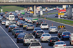
The project attracted a great deal of controversy just before it opened and well afterwards: in order to save costs, only one freeway-style interchange had been constructed (underneath High Street in Glen Iris). Every other interchange with major roads along the route (Toorak, Burke, Tooronga and Warrigal Roads) was an at-grade intersection controlled by traffic-lights, and because the road was constructed through residential areas, reduced speed limits were also enforced. This led to heavy congestion, frequently kilometres long, on the freeway, fuelling anger and frustration, and even attracting a rather-apt moniker of "the South-Eastern Carpark".
With a change of government several years later and a lot of political showmanship, more money was poured into the link road, constructing underpass interchanges at Toorak and Burke Roads (and just an underpass at Tooronga Road), and a new overpass across Warrigal Road. New noise barrier
s and extra lanes were also constructed, and the freeway 'upgrade' was completed and the entire length renamed back to the South Eastern Freeway, before changing name again to the now-current Monash Freeway, so named by Premier Kennett after General Sir John Monash
, arguably Australia's greatest soldier, engineer, scholar and nation builder. The improved road dramatically improved the rate of out-bound traffic, however the bottleneck at the Swan Street Bridge still remained and the queues only got longer. A portion of the Monash Freeway at the city end (from Toorak to Punt Roads) was eventually incorporated into the CityLink
project in the late 1990s by way of tunnels underneath the city to link to the eastern-end of the West Gate Freeway
, allowing for an uninterrupted voyage past the CBD.
The freeway was extended by 7.5 km in late 2003 when the Hallam Bypass was completed after 3 years of construction, connecting the Monash Freeway in Hallam to the Princes Freeway
in Berwick
. It opened 6 months ahead of schedule and A$80 million under budget due to the omission of one key interchange that should have linked the South Gippsland Freeway with the Hallam Bypass at Eummemmering. This omission causes unnecessary congestion on neighbouring roads as northbound South Gippsland Freeway traffic must exit the freeway at Princes Highway only to join the same freeway again from Belgrave-Hallam Road eastbound.
The Monash Freeway allows travel from Morwell
in the central Latrobe Valley, to Waurn Ponds
in the south-east of Geelong - via CityLink, the West Gate, the Geelong Ring Road and Princes Freeways. Motorists can cover over 200 km without encountering a set of traffic lights (except at Yarragon
and Trafalgar
, which are yet to be bypassed). The construction of the bypass also included the Hallam Bypass Trail
shared path.
and Transurban
.
, at Toorak Road. Here the freeway is four lanes wide. The opposing carriageways of the freeway are relatively near to each other and are separated by a concrete barrier. This section has overhead lighting. This first section of freeway runs through the south-eastern suburbs of Malvern
, Glen Iris
and Malvern East.
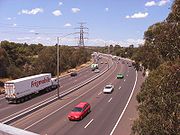
After Warrigal Road
, the freeway is built within a much wider road reserve, allowing for a wide grass centre median
with steel barrier separating the carriageways. This section does not have overhead lighting and carries four lanes on each carriageway. This section runs through south-eastern metropolitan Melbourne, including the suburbs of Chadstone
, Mount Waverley
, Mulgrave
, Dandenong
, Hallam
, and finally, Narre Warren
, where it becomes the Princes Freeway
. The final section, the Hallam Bypass, is the newest stretch of the Monash Freeway, and has two lanes in each carriageway.
Victoria (Australia)
Victoria is the second most populous state in Australia. Geographically the smallest mainland state, Victoria is bordered by New South Wales, South Australia, and Tasmania on Boundary Islet to the north, west and south respectively....
, Australia
Australia
Australia , officially the Commonwealth of Australia, is a country in the Southern Hemisphere comprising the mainland of the Australian continent, the island of Tasmania, and numerous smaller islands in the Indian and Pacific Oceans. It is the world's sixth-largest country by total area...
linking Melbourne
Melbourne
Melbourne is the capital and most populous city in the state of Victoria, and the second most populous city in Australia. The Melbourne City Centre is the hub of the greater metropolitan area and the Census statistical division—of which "Melbourne" is the common name. As of June 2009, the greater...
's CBD to its southeastern suburbs and the Gippsland
Gippsland
Gippsland is a large rural region in Victoria, Australia. It begins immediately east of the suburbs of Melbourne and stretches to the New South Wales border, lying between the Great Dividing Range to the north and Bass Strait to the south...
region. The entire stretch of the Monash Freeway bears the designation
. The freeway was originally shown in the 1969 Melbourne Transportation Plan1969 Melbourne Transportation Plan
The 1969 Melbourne Transportation Plan was a road and rail transport plan for Melbourne, the state capital of Victoria, Australia instituted by Henry Bolte's state government...
as part of the F9 and F14 Freeway corridors.
History
The Monash Freeway is an amalgamation of two initially separate freeways: the Mulgrave Freeway (initially designated) linking Warrigal Road, ChadstoneChadstone, Victoria
Chadstone is a suburb in Melbourne, Victoria, Australia. Its Local Government Area is the City of Monash. Landmarks include the Waverley Basketball Centre, Jordanville Community Centre and the Matthew Flinders Hotel...
to the Princes Highway
Princes Highway
The Princes Highway extends from Sydney to Port Augusta via the coast through the states of New South Wales, Victoria and South Australia, a distance of 1941 km or 1898 km via the former alignments of the highway ....
in Eumemmerring
Eumemmerring, Victoria
This article is about the suburb of Eumemmerring. For the Secondary College, see Eumemmerring College.Eumemmerring is a suburb in Melbourne, Victoria, Australia, 33 km south-east from Melbourne's central business district. Its Local Government Area is the City of Casey...
; and the South Eastern Freeway (initially designated
) linking Punt RoadHoddle Highway
Hoddle Highway is an urban highway in Melbourne linking CityLink and the Eastern Freeway, allotted metropolitan route . The name "Hoddle Highway" is almost completely unknown to most drivers - who refer instead to its constituent parts: Hoddle Street and Punt Road.It starts at the Eastern Freeway...
, Richmond
Richmond, Victoria
Richmond is a suburb in Melbourne, Victoria, Australia, 3 km south-east from Melbourne's central business district. Its Local Government Area is the City of Yarra...
and Toorak Road, Hawthorn East
Hawthorn East, Victoria
Hawthorn East is a suburb in Melbourne, Victoria, Australia, 9 km east from Melbourne's central business district. Its Local Government Area is the City of Boroondara...
.
Mulgrave Freeway
Initial construction on the Mulgrave Freeway started in 1970 and was completed in 1973, with bi-directional interchanges with Heatherton and Stud Roads. Later in the 1970s and in the early 1980s it was progressively extended westward to Forster Road - with additional interchanges at Blackburn, Ferntree Gully, Wellington and Jacksons Roads (and eventually Police Road during the early to mid 90's) - then to Huntingdale Road, and finally to Warrigal RoadWarrigal Road
Warrigal Road is a major inner urban road in southeastern Melbourne, Australia. On weekdays, it is usually congested as it runs through many major suburbs along its route, traversing Melbourne's inner eastern and south-eastern suburbs. This includes suburbs such as Chadstone, Oakleigh, and...
in Chadstone
Chadstone, Victoria
Chadstone is a suburb in Melbourne, Victoria, Australia. Its Local Government Area is the City of Monash. Landmarks include the Waverley Basketball Centre, Jordanville Community Centre and the Matthew Flinders Hotel...
. Construction at the Hallam end extended underneath an interchange at the Princes Highway and southwards along the old alignment of the South Gippsland Highway to the interchange with Dandenong-Hastings Road, now the Westernport Highway
Westernport Highway
Westernport Highway / is a highway in Victoria, Australia, linking the south-eastern fringe of suburban Melbourne to the western coast of Western Port Bay, after which the highway is named, at the Port of Hastings nearly 30km to the south...
at Lyndhurst; this section was initially named the Eumemmerring Freeway, but later named the South Gippsland Freeway
South Gippsland Freeway
South Gippsland Freeway is a short freeway linking Dandenong in Melbourne's south-east to other south-eastern destinations, including the Mornington Peninsula and the Gippsland region...
. The
designation was dropped in 1988, coinciding with the opening of the South Eastern Arterial.Interestingly at this time the Tullamarine Freeway
Tullamarine Freeway
The Tullamarine Freeway is an urban freeway in Melbourne, Australia, linking Melbourne Airport to the central business district.-History:Tullamarine Freeway is one of the oldest freeways in Melbourne, originally constructed in 1968-1970...
also carried the
route shield. This was due to the 1969 Melbourne Transportation Plan1969 Melbourne Transportation Plan
The 1969 Melbourne Transportation Plan was a road and rail transport plan for Melbourne, the state capital of Victoria, Australia instituted by Henry Bolte's state government...
having the two freeways linked to each other from around East Malvern (at the Mulgrave Freeway end) and at Flemington (at the Tullamarine Freeway end), sweeping through the St Kilda area. The plan never came to fruition, but the two freeways have since been linked by the West Gate Freeway
West Gate Freeway
West Gate Freeway is a freeway in Melbourne, Australia, linking Geelong to Melbourne CBD and beyond. It is also a link between Melbourne and the west and linking industrial and residential areas west of the Yarra River with the city and port areas. The iconic West Gate Bridge is a part of the...
extension and the CityLink
CityLink
CityLink is a system of tolled urban Highways in Melbourne, Victoria, Australia. The company Transurban was awarded the contract to augment two existing freeways and construct two new Toll roads—labelled the Western and Southern Links—directly linking a number of existing freeways to...
project.
South Eastern Freeway
Initial construction of the South Eastern Freeway had completed by the mid-1960s, connecting Burnley to Olympic Park at Harcourt Parade, which fed traffic to Punt Road at the Hoddle BridgeHoddle Bridge
The Hoddle Bridge is a bridge over the Yarra River between Richmond and South Yarra, Melbourne, Australia. It carries Punt Road across the Yarra. It is a four-lane road bridge with narrow footpaths on either side...
: an overpass across Punt Road quickly followed to end at Anderson Street and the Morell Bridge
Morell Bridge
The Morell Bridge is a bridge over the Yarra River in South Yarra, Melbourne, Australia. Completed in 1899 by John Monash and J. T. N. Anderson, it is notable for being the first bridge in Victoria to be built using reinforced concrete....
, with a single-carriageway feeder road to the Swan Street Bridge (and Batman Avenue) 800 metres beyond. The freeway was eventually further extended east from Burnley under the MacRobertson Bridge
MacRobertson Bridge
The MacRobertson Bridge is a road bridge that carries Grange Road from Toorak on the south bank into Burnley, over the Yarra River and the Monash Freeway in Melbourne, Victoria, Australia....
along the Yarra, to Toorak Road (with a single-carriageway feeder road taking excess traffic to Tooronga Road. Part of the road still exists along the Home Hardware store which can be seen from the Tooronga road overpass of the Monash Fwy. This was completed in 1971. Initially designated
in the 1960s, it was later signed as until 1988, when the South Eastern Arterial was completed.South Eastern arterial link
The resulting gap between the Toorak / Burke Road end of the South Eastern Freeway and the Warrigal Road end of the Mulgrave Freeway frustrated drivers for many years, needing to rely increasingly on feeder roads to bridge the distance between them. The State Government proposed a road to connect them during the mid-1980s, before finally agreeing on an alignment and allowing construction to commence on a dual-carriageway link between the freeways; construction finished in 1988, and the link - and later the entire length of the now-connected freeway, from the city to Eumemmerring - was re-christened as the South Eastern Arterial; the new stretch of road also re-designated, with the Princes HighwayPrinces Highway
The Princes Highway extends from Sydney to Port Augusta via the coast through the states of New South Wales, Victoria and South Australia, a distance of 1941 km or 1898 km via the former alignments of the highway ....
(Dandenong Road) becoming an alternative route.
The project attracted a great deal of controversy just before it opened and well afterwards: in order to save costs, only one freeway-style interchange had been constructed (underneath High Street in Glen Iris). Every other interchange with major roads along the route (Toorak, Burke, Tooronga and Warrigal Roads) was an at-grade intersection controlled by traffic-lights, and because the road was constructed through residential areas, reduced speed limits were also enforced. This led to heavy congestion, frequently kilometres long, on the freeway, fuelling anger and frustration, and even attracting a rather-apt moniker of "the South-Eastern Carpark".
With a change of government several years later and a lot of political showmanship, more money was poured into the link road, constructing underpass interchanges at Toorak and Burke Roads (and just an underpass at Tooronga Road), and a new overpass across Warrigal Road. New noise barrier
Noise barrier
A noise barrier is an exterior structure designed to protect sensitive land uses from noise pollution...
s and extra lanes were also constructed, and the freeway 'upgrade' was completed and the entire length renamed back to the South Eastern Freeway, before changing name again to the now-current Monash Freeway, so named by Premier Kennett after General Sir John Monash
John Monash
General Sir John Monash GCMG, KCB, VD was a civil engineer who became the Australian military commander in the First World War. He commanded the 13th Infantry Brigade before the War and then became commander of the 4th Brigade in Egypt shortly after the outbreak of the War with whom he took part...
, arguably Australia's greatest soldier, engineer, scholar and nation builder. The improved road dramatically improved the rate of out-bound traffic, however the bottleneck at the Swan Street Bridge still remained and the queues only got longer. A portion of the Monash Freeway at the city end (from Toorak to Punt Roads) was eventually incorporated into the CityLink
CityLink
CityLink is a system of tolled urban Highways in Melbourne, Victoria, Australia. The company Transurban was awarded the contract to augment two existing freeways and construct two new Toll roads—labelled the Western and Southern Links—directly linking a number of existing freeways to...
project in the late 1990s by way of tunnels underneath the city to link to the eastern-end of the West Gate Freeway
West Gate Freeway
West Gate Freeway is a freeway in Melbourne, Australia, linking Geelong to Melbourne CBD and beyond. It is also a link between Melbourne and the west and linking industrial and residential areas west of the Yarra River with the city and port areas. The iconic West Gate Bridge is a part of the...
, allowing for an uninterrupted voyage past the CBD.
Hallam bypass
Before this bypass was constructed, the sweeping curve of the freeway at the Hallam end that became the South Gippsland Freeway had its capacity reduced from three lanes to two, resulting in a notorious bottle-neck at peak hours, especially for out-bound traffic exiting at the Princes Highway interchange outside Dandenong; the extension finally bypassed the entire problem.The freeway was extended by 7.5 km in late 2003 when the Hallam Bypass was completed after 3 years of construction, connecting the Monash Freeway in Hallam to the Princes Freeway
Princes Freeway
The Princes Freeway is a , 2 section freeway, which links Melbourne to Geelong on the west and Morwell on the east . It continues beyond these extremities as the Princes Highway towards Adelaide to the west and Sydney to the east...
in Berwick
Berwick, Victoria
Berwick is a suburb in Melbourne, Victoria, Australia, south-east from Melbourne's central business district. Its Local Government Area is the City of Casey. At the 2006 Census, Berwick had a population of 36,420....
. It opened 6 months ahead of schedule and A$80 million under budget due to the omission of one key interchange that should have linked the South Gippsland Freeway with the Hallam Bypass at Eummemmering. This omission causes unnecessary congestion on neighbouring roads as northbound South Gippsland Freeway traffic must exit the freeway at Princes Highway only to join the same freeway again from Belgrave-Hallam Road eastbound.
The Monash Freeway allows travel from Morwell
Morwell, Victoria
-Transport:The main form of transport in Morwell is the automobile. The Princes Freeway now bypasses the town to the south while the old Princes Highway which once passed through east-west through its centre is now Princes Drive and Commercial Road. The highway connects Morwell with other...
in the central Latrobe Valley, to Waurn Ponds
Waurn Ponds, Victoria
Waurn Ponds is a mainly residential southern suburb of Geelong, Victoria, Australia.The suburb is bounded by Rossack Drive, Princes Highway, the Geelong to Warnambool railway, Reservoir Road, Draytons Road, Pigdons Road, Deakin University and Honeys Road....
in the south-east of Geelong - via CityLink, the West Gate, the Geelong Ring Road and Princes Freeways. Motorists can cover over 200 km without encountering a set of traffic lights (except at Yarragon
Yarragon, Victoria
Yarragon is a small town in the West Gippsland region of Victoria, Australia. The town lies on the Princes Highway and the main Gippsland Railway line approximately halfway between the major towns of Warragul and Moe...
and Trafalgar
Trafalgar, Victoria
Trafalgar is a town in the West Gippsland region of Victoria, Australia. The town lies on the Princes Highway and main Gippsland railway line about west of Moe. The town backs onto the foothills of the Strzelecki Ranges to the south...
, which are yet to be bypassed). The construction of the bypass also included the Hallam Bypass Trail
Hallam Bypass Trail
The Hallam Bypass Trail is a shared use path for cyclists and pedestrians running along the Hallam Bypass between Doveton and Berwick in the outer eastern suburbs of Melbourne, Victoria, Australia.The trail was completed in 2003.-Route:...
shared path.
Major upgrade
In 2007, the State Government announced a major upgrade widening the lanes from Glenferrie Road through to Heatherton Road. Prior to this, over 160,000 vehicles per day used this freeway resulting in congestion during peak hours. The upgrade started in late 2007 and was expected to be completed in late 2009. The entire project is known as the Monash-CityLink-West Gate upgrade, and is being carried out by VicRoadsVicRoads
VicRoads or the Roads Corporation of Victoria is a statutory corporation which is the state road and traffic authority in the state of Victoria, Australia. It is responsible for maintenance and construction of the state arterial road network, as well as driver licensing and vehicle registration. ...
and Transurban
Transurban
Transurban is an international toll road developer and manager with interests in Australia and North America. In Australia, Transurban has a stake in five out of Sydney’s nine motorways, and in Melbourne it is the full owner of CityLink, which connects three of the city’s major freeways...
.
Route and conditions
The freeway officially begins at the southern end of CityLinkCityLink
CityLink is a system of tolled urban Highways in Melbourne, Victoria, Australia. The company Transurban was awarded the contract to augment two existing freeways and construct two new Toll roads—labelled the Western and Southern Links—directly linking a number of existing freeways to...
, at Toorak Road. Here the freeway is four lanes wide. The opposing carriageways of the freeway are relatively near to each other and are separated by a concrete barrier. This section has overhead lighting. This first section of freeway runs through the south-eastern suburbs of Malvern
Malvern, Victoria
Malvern is a suburb in Melbourne, Victoria, Australia, 8 km south-east from Melbourne's central business district. Its Local Government Area is the City of Stonnington. At the 2006 Census, Malvern had a population of 9,422.-History:...
, Glen Iris
Glen Iris, Victoria
Glen Iris is a suburb in Melbourne, Victoria, Australia, 10 km south-east from Melbourne's central business district. Its Local Government Area are the Cities of Boroondara and Stonnington...
and Malvern East.
After Warrigal Road
Warrigal Road
Warrigal Road is a major inner urban road in southeastern Melbourne, Australia. On weekdays, it is usually congested as it runs through many major suburbs along its route, traversing Melbourne's inner eastern and south-eastern suburbs. This includes suburbs such as Chadstone, Oakleigh, and...
, the freeway is built within a much wider road reserve, allowing for a wide grass centre median
Median
In probability theory and statistics, a median is described as the numerical value separating the higher half of a sample, a population, or a probability distribution, from the lower half. The median of a finite list of numbers can be found by arranging all the observations from lowest value to...
with steel barrier separating the carriageways. This section does not have overhead lighting and carries four lanes on each carriageway. This section runs through south-eastern metropolitan Melbourne, including the suburbs of Chadstone
Chadstone, Victoria
Chadstone is a suburb in Melbourne, Victoria, Australia. Its Local Government Area is the City of Monash. Landmarks include the Waverley Basketball Centre, Jordanville Community Centre and the Matthew Flinders Hotel...
, Mount Waverley
Mount Waverley, Victoria
Mount Waverley is a suburb in Melbourne, Victoria, Australia, 16 km south-east from Melbourne's central business district. Its Local Government Area is the City of Monash...
, Mulgrave
Mulgrave, Victoria
Mulgrave is a suburb in Melbourne, Victoria, Australia, 21 km south-east from Melbourne's central business district. Its Local Government Area is the City of Monash. At the 2006 Census, Mulgrave had a population of 16,280....
, Dandenong
Dandenong, Victoria
Dandenong is a suburb and major urban centre in metropolitan Melbourne, Victoria, Australia, 30 km south-east from Melbourne's central business district. Situated on Dandenong Creek and mostly flat land at the foothills of Mount Dandenong, it is the main administrative centre for the City of...
, Hallam
Hallam, Victoria
Hallam is a suburb in Melbourne, Victoria, Australia, 35 km south-east from Melbourne's central business district. Its Local Government Area is the City of Casey...
, and finally, Narre Warren
Narre Warren, Victoria
Narre Warren is a suburb of Melbourne, Victoria, Australia, 42 km south east from Melbourne's central business district. Its Local Government Area is the City of Casey. At the 2006 Census, Narre Warren had a population of 25,667. Narre Warren has a population density of over 2000 people per square...
, where it becomes the Princes Freeway
Princes Freeway
The Princes Freeway is a , 2 section freeway, which links Melbourne to Geelong on the west and Morwell on the east . It continues beyond these extremities as the Princes Highway towards Adelaide to the west and Sydney to the east...
. The final section, the Hallam Bypass, is the newest stretch of the Monash Freeway, and has two lanes in each carriageway.
Exits and interchanges
| Monash Freeway |
||
| Northbound exits | Exit Number Distance to Melbourne |
Southbound exits |
| End Monash Freeway continues as CityLink CityLink CityLink is a system of tolled urban Highways in Melbourne, Victoria, Australia. The company Transurban was awarded the contract to augment two existing freeways and construct two new Toll roads—labelled the Western and Southern Links—directly linking a number of existing freeways to... to Melbourne Melbourne Melbourne is the capital and most populous city in the state of Victoria, and the second most populous city in Australia. The Melbourne City Centre is the hub of the greater metropolitan area and the Census statistical division—of which "Melbourne" is the common name. As of June 2009, the greater...  |
-- (9km) |
Start Monash Freeway from CityLink CityLink CityLink is a system of tolled urban Highways in Melbourne, Victoria, Australia. The company Transurban was awarded the contract to augment two existing freeways and construct two new Toll roads—labelled the Western and Southern Links—directly linking a number of existing freeways to... |
| Toorak Toorak, Victoria Toorak is a suburb of Melbourne, Victoria, Australia, 5 km south-east from Melbourne's central business district located on a rise on the south side of a bend in the Yarra River. Its Local Government Area is the City of Stonnington... , Burwood Burwood, Victoria Burwood is a suburb in Melbourne, Victoria, Australia, 17 km east from Melbourne's central business district. Its Local Government Area is largely the City of Whitehorse but includes the City of Monash in its south west corner. At the 2006 Census, Burwood had a population of 11,886.-History:The... Toorak Road Burwood Highway Burwood Highway is a major transportation link with Melbourne's eastern suburbs. It begins in the suburb of Kooyong, Melbourne at the junction of the Monash Freeway as Toorak Road between Monash Freeway and Warrigal Road, and finishes in Belgrave, Victoria in the Dandenong Ranges...  |
E4 (9km) |
|
| Caulfield Caulfield, Victoria Caulfield is a suburb in Melbourne, Victoria, Australia, 12 km south-east from Melbourne's central business district. Its Local Government Area is the City of Glen Eira... , Camberwell Camberwell, Victoria Camberwell is a suburb in Melbourne, Victoria, Australia, 9 km east from Melbourne's central business district. Its Local Government Area is the City of Boroondara. At the 2006 Census, Camberwell had a population of 19,637.... Burke Road Burke Road, Melbourne Burke Road is a major north-south thoroughfare in Melbourne, Australia. It runs from Ivanhoe to Caulfield, and includes the major shopping district at Camberwell...  |
E5 (11km) |
Camberwell Camberwell, Victoria Camberwell is a suburb in Melbourne, Victoria, Australia, 9 km east from Melbourne's central business district. Its Local Government Area is the City of Boroondara. At the 2006 Census, Camberwell had a population of 19,637.... , Caulfield Caulfield, Victoria Caulfield is a suburb in Melbourne, Victoria, Australia, 12 km south-east from Melbourne's central business district. Its Local Government Area is the City of Glen Eira... Burke Road Burke Road, Melbourne Burke Road is a major north-south thoroughfare in Melbourne, Australia. It runs from Ivanhoe to Caulfield, and includes the major shopping district at Camberwell... |
| no exit | E6 (12km) |
Glen Waverley Glen Waverley, Victoria Glen Waverley is a suburb in Melbourne, Victoria, Australia, 19 km south-east from Melbourne's central business district. Its Local Government Area is the City of Monash... , Glen Iris Glen Iris, Victoria Glen Iris is a suburb in Melbourne, Victoria, Australia, 10 km south-east from Melbourne's central business district. Its Local Government Area are the Cities of Boroondara and Stonnington... High Street  |
| GLEN WAVERLEY RAIL LINE | -- (16km) |
GLEN WAVERLEY RAIL LINE |
| Oakleigh Oakleigh, Victoria Oakleigh is a suburb of Melbourne, Victoria, Australia and is located 14 km south-east from Melbourne's central business district. Its Local Government Area is the City of Monash. At the 2006 Census, Oakleigh had a population of 6,876.... , Chadstone Chadstone, Victoria Chadstone is a suburb in Melbourne, Victoria, Australia. Its Local Government Area is the City of Monash. Landmarks include the Waverley Basketball Centre, Jordanville Community Centre and the Matthew Flinders Hotel... Warrigal Road Warrigal Road Warrigal Road is a major inner urban road in southeastern Melbourne, Australia. On weekdays, it is usually congested as it runs through many major suburbs along its route, traversing Melbourne's inner eastern and south-eastern suburbs. This includes suburbs such as Chadstone, Oakleigh, and...  |
E7 (17km) |
Chadstone Chadstone, Victoria Chadstone is a suburb in Melbourne, Victoria, Australia. Its Local Government Area is the City of Monash. Landmarks include the Waverley Basketball Centre, Jordanville Community Centre and the Matthew Flinders Hotel... , Oakleigh Oakleigh, Victoria Oakleigh is a suburb of Melbourne, Victoria, Australia and is located 14 km south-east from Melbourne's central business district. Its Local Government Area is the City of Monash. At the 2006 Census, Oakleigh had a population of 6,876.... Warrigal Road Warrigal Road Warrigal Road is a major inner urban road in southeastern Melbourne, Australia. On weekdays, it is usually congested as it runs through many major suburbs along its route, traversing Melbourne's inner eastern and south-eastern suburbs. This includes suburbs such as Chadstone, Oakleigh, and... |
| Huntingdale Huntingdale, Victoria Huntingdale is a suburb in Melbourne, Victoria, Australia, 16 km south-east from Melbourne's central business district. Its Local Government Area is the City of Monash... , Burwood Burwood, Victoria Burwood is a suburb in Melbourne, Victoria, Australia, 17 km east from Melbourne's central business district. Its Local Government Area is largely the City of Whitehorse but includes the City of Monash in its south west corner. At the 2006 Census, Burwood had a population of 11,886.-History:The... Huntingdale Road  |
8 (18km) |
no exit |
| Clayton Clayton, Victoria Clayton is a suburb in Melbourne, Victoria, Australia, 19 km south-east from Melbourne's central business district. Its Local Government Area is the City of Monash. At the 2006 Census, Clayton had a population of 14,332.-Overview:... , Mount Waverley Mount Waverley, Victoria Mount Waverley is a suburb in Melbourne, Victoria, Australia, 16 km south-east from Melbourne's central business district. Its Local Government Area is the City of Monash... Forster Road |
9 (20km) |
Mount Waverley Mount Waverley, Victoria Mount Waverley is a suburb in Melbourne, Victoria, Australia, 16 km south-east from Melbourne's central business district. Its Local Government Area is the City of Monash... , Clayton Clayton, Victoria Clayton is a suburb in Melbourne, Victoria, Australia, 19 km south-east from Melbourne's central business district. Its Local Government Area is the City of Monash. At the 2006 Census, Clayton had a population of 14,332.-Overview:... Forster Road |
| Edithvale Edithvale, Victoria Edithvale is a suburb in Melbourne, Victoria, Australia, 28 km south-east from Melbourne's central business district. Its Local Government Area is the City of Kingston. At the 2006 Census, Edithvale had a population of 4991.-Public transport:... , Blackburn Blackburn, Victoria Blackburn is a suburb in Melbourne, Victoria, Australia, 17 km east from Melbourne's central business district. Its Local Government Area is the City of Whitehorse. At the 2006 Census, Blackburn had a population of 11,958.... Blackburn Road  |
10 (21km) |
Blackburn Blackburn, Victoria Blackburn is a suburb in Melbourne, Victoria, Australia, 17 km east from Melbourne's central business district. Its Local Government Area is the City of Whitehorse. At the 2006 Census, Blackburn had a population of 11,958.... , Edithvale Edithvale, Victoria Edithvale is a suburb in Melbourne, Victoria, Australia, 28 km south-east from Melbourne's central business district. Its Local Government Area is the City of Kingston. At the 2006 Census, Edithvale had a population of 4991.-Public transport:... Blackburn Road |
| no exit | 11 (22km) |
Ferntree Gully Ferntree Gully, Victoria Ferntree Gully is a suburb in Melbourne, Victoria, Australia, in the Dandenong Ranges, 29 km east from Melbourne's central business district. It is in the Local Government Area's of the Shire of Yarra Ranges and the City of Knox... , Mount Dandenong Mount Dandenong, Victoria Mount Dandenong is both a mountain and small township/suburb of Greater Melbourne, Victoria, Australia, 35 km east from Melbourne's central business district. Its Local Government Area is the Shire of Yarra Ranges... Ferntree Gully Road  |
| Springvale Springvale, Victoria Springvale is a suburb in Melbourne, Victoria, Australia, approximately 20 km south-east from Melbourne's central business district. Its Local Government Area is the City of Greater Dandenong... , Glen Waverley Glen Waverley, Victoria Glen Waverley is a suburb in Melbourne, Victoria, Australia, 19 km south-east from Melbourne's central business district. Its Local Government Area is the City of Monash... Springvale Road  |
12 (23km) |
no exit |
| Oakleigh Oakleigh, Victoria Oakleigh is a suburb of Melbourne, Victoria, Australia and is located 14 km south-east from Melbourne's central business district. Its Local Government Area is the City of Monash. At the 2006 Census, Oakleigh had a population of 6,876.... , Ormond Ormond, Victoria Ormond is a suburb in Melbourne, Victoria, Australia, 12 km south-east from Melbourne's central business district. Its Local Government Area is the City of Glen Eira. At the 2006 Census, Ormond had a population of 7152.... Wellington Road  |
13 (25km) |
Rowville Rowville, Victoria Rowville is a suburb in Melbourne, Victoria, Australia, 29 km south-east from Melbourne's central business district. Its Local Government Area is the City of Knox. At the 2006 Census, Rowville had a population of 34,412.... , Emerald Emerald, Victoria Emerald is a town and semi-rural locality in the Greater Melbourne area, Victoria, Australia, 44 km south-east from Melbourne's central business district, outside the urban area. Its Local Government Area are the Shires of Cardinia and Yarra Ranges... Wellington Road |
| no exit | 14 (27km) |
Mulgrave Mulgrave, Victoria Mulgrave is a suburb in Melbourne, Victoria, Australia, 21 km south-east from Melbourne's central business district. Its Local Government Area is the City of Monash. At the 2006 Census, Mulgrave had a population of 16,280.... , Noble Park Noble Park, Victoria Noble Park is a suburb in Melbourne, Victoria, Australia, 26 km south-east from Melbourne's central business district. Its Local Government Area is the City of Greater Dandenong... Jacksons Road |
| Springvale Springvale, Victoria Springvale is a suburb in Melbourne, Victoria, Australia, approximately 20 km south-east from Melbourne's central business district. Its Local Government Area is the City of Greater Dandenong... , Dandenong North Dandenong North, Victoria Dandenong North is a suburb in Melbourne, Victoria, Australia, 29 km south-east from Melbourne's central business district. Its Local Government Area is the City of Greater Dandenong... Police Road  |
15 (28km) |
no exit |
| TOM WILLS INTERCHANGE Ringwood Ringwood, Victoria Ringwood is a suburb in Melbourne, Victoria, Australia, east of Melbourne's central business district. Its Local Government Area is the City of Maroondah. At the 2006 Census, Ringwood had a population of 15,185.... EastLink EastLink, Melbourne EastLink is a A$2.5 billion tolled freeway linking a large area through the eastern and south-eastern suburbs of Melbourne, Australia. It is a part of Melbourne's Metropolitan Ring Road project....  |
16 (29km) |
TOM WILLS INTERCHANGE Ringwood Ringwood, Victoria Ringwood is a suburb in Melbourne, Victoria, Australia, east of Melbourne's central business district. Its Local Government Area is the City of Maroondah. At the 2006 Census, Ringwood had a population of 15,185.... , Frankston Frankston, Victoria Frankston is a suburb within the Greater Melbourne metropolitan area in Victoria, Australia. It is located 40 km southeast of the state capital Melbourne at the southernmost edge of Greater Melbourne, near the beginnings of the Mornington Peninsula... EastLink EastLink, Melbourne EastLink is a A$2.5 billion tolled freeway linking a large area through the eastern and south-eastern suburbs of Melbourne, Australia. It is a part of Melbourne's Metropolitan Ring Road project.... |
| Dandenong Dandenong, Victoria Dandenong is a suburb and major urban centre in metropolitan Melbourne, Victoria, Australia, 30 km south-east from Melbourne's central business district. Situated on Dandenong Creek and mostly flat land at the foothills of Mount Dandenong, it is the main administrative centre for the City of... , Rowville Rowville, Victoria Rowville is a suburb in Melbourne, Victoria, Australia, 29 km south-east from Melbourne's central business district. Its Local Government Area is the City of Knox. At the 2006 Census, Rowville had a population of 34,412.... Stud Road Dandenong Valley Highway The Dandenong Valley Highway stretches almost 30 kilometres from Wantirna South in Melbourne's eastern suburbs to Frankston in the south. For its entire length, its main name is not actually Dandenong Valley Highway, and very few locals use it...  |
17 (31km) |
Rowville Rowville, Victoria Rowville is a suburb in Melbourne, Victoria, Australia, 29 km south-east from Melbourne's central business district. Its Local Government Area is the City of Knox. At the 2006 Census, Rowville had a population of 34,412.... , Dandenong Dandenong, Victoria Dandenong is a suburb and major urban centre in metropolitan Melbourne, Victoria, Australia, 30 km south-east from Melbourne's central business district. Situated on Dandenong Creek and mostly flat land at the foothills of Mount Dandenong, it is the main administrative centre for the City of... Stud Road Dandenong Valley Highway The Dandenong Valley Highway stretches almost 30 kilometres from Wantirna South in Melbourne's eastern suburbs to Frankston in the south. For its entire length, its main name is not actually Dandenong Valley Highway, and very few locals use it... |
| Dandenong North Dandenong North, Victoria Dandenong North is a suburb in Melbourne, Victoria, Australia, 29 km south-east from Melbourne's central business district. Its Local Government Area is the City of Greater Dandenong... , Endeavour Hills Endeavour Hills, Victoria Endeavour Hills is a suburb in Melbourne, Victoria, Australia, south-east from Melbourne's central business district. Its Local Government Area is the City of Casey... Heatherton Road  |
18 (33km) |
Endeavour Hills Endeavour Hills, Victoria Endeavour Hills is a suburb in Melbourne, Victoria, Australia, south-east from Melbourne's central business district. Its Local Government Area is the City of Casey... , Dandenong North Dandenong North, Victoria Dandenong North is a suburb in Melbourne, Victoria, Australia, 29 km south-east from Melbourne's central business district. Its Local Government Area is the City of Greater Dandenong... Heatherton Road |
| Cranbourne Cranbourne, Victoria Cranbourne is a suburb in Melbourne, Victoria, Australia, 43 km south-east from Melbourne's central business district. Its Local Government Area is the City of Casey. At the 2006 Census, Cranbourne had a population of 14,750.... , Hastings Hastings, Victoria Hastings is a suburb on the Mornington Peninsula, Victoria, Australia, as a part of the urban enclave on Westernport comprising Hastings, Bittern, Crib Point, Tyabb, and Somerville. Its Local Government Area is the Shire of Mornington Peninsula... South Gippsland Freeway South Gippsland Freeway South Gippsland Freeway is a short freeway linking Dandenong in Melbourne's south-east to other south-eastern destinations, including the Mornington Peninsula and the Gippsland region...  |
19 (36km) |
Cranbourne Cranbourne, Victoria Cranbourne is a suburb in Melbourne, Victoria, Australia, 43 km south-east from Melbourne's central business district. Its Local Government Area is the City of Casey. At the 2006 Census, Cranbourne had a population of 14,750.... , Hastings Hastings, Victoria Hastings is a suburb on the Mornington Peninsula, Victoria, Australia, as a part of the urban enclave on Westernport comprising Hastings, Bittern, Crib Point, Tyabb, and Somerville. Its Local Government Area is the Shire of Mornington Peninsula... South Gippsland Freeway South Gippsland Freeway South Gippsland Freeway is a short freeway linking Dandenong in Melbourne's south-east to other south-eastern destinations, including the Mornington Peninsula and the Gippsland region... |
| Hallam Hallam, Victoria Hallam is a suburb in Melbourne, Victoria, Australia, 35 km south-east from Melbourne's central business district. Its Local Government Area is the City of Casey... , Endeavour Hills Endeavour Hills, Victoria Endeavour Hills is a suburb in Melbourne, Victoria, Australia, south-east from Melbourne's central business district. Its Local Government Area is the City of Casey... Belgrave-Hallam Road |
20 (38km) |
Endeavour Hills Endeavour Hills, Victoria Endeavour Hills is a suburb in Melbourne, Victoria, Australia, south-east from Melbourne's central business district. Its Local Government Area is the City of Casey... , Hallam Hallam, Victoria Hallam is a suburb in Melbourne, Victoria, Australia, 35 km south-east from Melbourne's central business district. Its Local Government Area is the City of Casey... Belgrave-Hallam Road |
| no exit | 21 (39km) |
Ernst Wanke Road |
| Cranbourne Cranbourne, Victoria Cranbourne is a suburb in Melbourne, Victoria, Australia, 43 km south-east from Melbourne's central business district. Its Local Government Area is the City of Casey. At the 2006 Census, Cranbourne had a population of 14,750.... , Belgrave Belgrave, Victoria Belgrave is a suburb in Melbourne, Victoria, Australia, 35 km east from Melbourne's central business district. Its Local Government Area is the Shire of Yarra Ranges. At the 2006 Census, Belgrave had a population of 4094... Narre Warren North Road  |
22 (42km) |
Belgrave Belgrave, Victoria Belgrave is a suburb in Melbourne, Victoria, Australia, 35 km east from Melbourne's central business district. Its Local Government Area is the Shire of Yarra Ranges. At the 2006 Census, Belgrave had a population of 4094... , Cranbourne Cranbourne, Victoria Cranbourne is a suburb in Melbourne, Victoria, Australia, 43 km south-east from Melbourne's central business district. Its Local Government Area is the City of Casey. At the 2006 Census, Cranbourne had a population of 14,750.... Narre Warren North Road |
| Start Monash Freeway continues from Princes Freeway East Princes Freeway The Princes Freeway is a , 2 section freeway, which links Melbourne to Geelong on the west and Morwell on the east . It continues beyond these extremities as the Princes Highway towards Adelaide to the west and Sydney to the east... |
23 (44km) |
Berwick Berwick, Victoria Berwick is a suburb in Melbourne, Victoria, Australia, south-east from Melbourne's central business district. Its Local Government Area is the City of Casey. At the 2006 Census, Berwick had a population of 36,420.... , Dandenong Dandenong, Victoria Dandenong is a suburb and major urban centre in metropolitan Melbourne, Victoria, Australia, 30 km south-east from Melbourne's central business district. Situated on Dandenong Creek and mostly flat land at the foothills of Mount Dandenong, it is the main administrative centre for the City of... Princes Highway Princes Highway The Princes Highway extends from Sydney to Port Augusta via the coast through the states of New South Wales, Victoria and South Australia, a distance of 1941 km or 1898 km via the former alignments of the highway ....   |
| -- (44km) |
End Monash Freeway continues as Princes Freeway East Princes Freeway The Princes Freeway is a , 2 section freeway, which links Melbourne to Geelong on the west and Morwell on the east . It continues beyond these extremities as the Princes Highway towards Adelaide to the west and Sydney to the east... to Warragul Warragul, Victoria Warragul is a rural centre with a population of 12,943 people east-southeast of Melbourne in Victoria. Warragul lies between the Strzelecki Ranges to the south and the Mount Baw Baw Plateau of the Great Dividing Range to the north... / Traralgon Traralgon, Victoria Traralgon is a regional city located in the Latrobe Valley in the Gippsland region of Victoria, Australia. Traralgon is a city within the City of Latrobe.... |
|
See also
- Freeways in AustraliaFreeways in AustraliaThis is a list of freeways and motorways in Australia, sorted by states and territories and their corresponding routes. This list includes toll roads such as the CityLink freeway system in Melbourne. This list has over 70 entries...
- Freeways in Melbourne
- Road transport in Victoria