

Port Wakefield Road
Encyclopedia
Port Wakefield Road is an important Australia
n highway. It connects Adelaide
, the South Australia
n capital, to the Yorke Peninsula
, Port Augusta
, northern and western South Australia, the Northern Territory
and Western Australia
. It is designated National Highway A1
and a part of the National Highway
. It is named after Port Wakefield
, the first government town north of Adelaide.
Port Wakefield Road branches off of Main North Road
at Gepps Cross
in the northern suburbs of Adelaide. The highway is dual-carriageway until Port Wakefield and bypasses all of the small towns along its former route. The original bypass of Port Wakefield is now built up with roadhouse
s and other businesses, leading to calls to build a new bypass further east.
In 2011 an upgrade including road widening of nine kilometers of Port Wakefield Road between Salisbury Highway
and Waterloo Corner Road was completed as part of the Northern Expressway
project.
 Port Wakefield Road passes through the northern Adelaide Plains
. To the west of the road is the coastal fringe of upper Gulf St Vincent, including a number of fishing and holiday villages. To the east is rich cropping and farming land.
The list of towns on or near the road include:
Australia
Australia , officially the Commonwealth of Australia, is a country in the Southern Hemisphere comprising the mainland of the Australian continent, the island of Tasmania, and numerous smaller islands in the Indian and Pacific Oceans. It is the world's sixth-largest country by total area...
n highway. It connects Adelaide
Adelaide
Adelaide is the capital city of South Australia and the fifth-largest city in Australia. Adelaide has an estimated population of more than 1.2 million...
, the South Australia
South Australia
South Australia is a state of Australia in the southern central part of the country. It covers some of the most arid parts of the continent; with a total land area of , it is the fourth largest of Australia's six states and two territories.South Australia shares borders with all of the mainland...
n capital, to the Yorke Peninsula
Yorke Peninsula
The Yorke Peninsula is a peninsula located north-west and west of Adelaide in South Australia, Australia, between Spencer Gulf on the west and Gulf St Vincent on the east. It has geographic coordinates of...
, Port Augusta
Port Augusta, South Australia
-Electricity generation:Electricity is generated at the Playford B and Northern power stations from brown coal mined at Leigh Creek, 250 km to the north...
, northern and western South Australia, the Northern Territory
Northern Territory
The Northern Territory is a federal territory of Australia, occupying much of the centre of the mainland continent, as well as the central northern regions...
and Western Australia
Western Australia
Western Australia is a state of Australia, occupying the entire western third of the Australian continent. It is bounded by the Indian Ocean to the north and west, the Great Australian Bight and Indian Ocean to the south, the Northern Territory to the north-east and South Australia to the south-east...
. It is designated National Highway A1
Highway 1 (Australia)
Australia's Highway 1 is a network of highways that circumnavigate the Australian continent, joining all mainland state capitals. At a total length of approximately it is the longest national highway in the world, longer than the Trans-Siberian Highway and the Trans-Canada Highway...
and a part of the National Highway
National Highway (Australia)
thumb|right|150px|The National Highway Shield in NSW, QLD, WA, NT & TAS.The National Highway is a system of roads connecting all the States and Territories of Australia, and is the major network of highways connecting Australia's largest and most important cities.The National Highway was...
. It is named after Port Wakefield
Port Wakefield, South Australia
Port Wakefield was the first government town to be established north of the capital, Adelaide, in South Australia.Port Wakefield is situated approximately 98.7 kilometres from Adelaide and lies on the Port Wakefield Road section of the A1 National Highway...
, the first government town north of Adelaide.
Port Wakefield Road branches off of Main North Road
Main North Road
Main North Road is the major north-south arterial route north of the city of Adelaide, South Australia.From the Adelaide city centre, it passes through the Adelaide Parklands and the suburbs of Thorngate, Medindie, Medindie Gardens, Nailsworth, Prospect, Sefton Park, Blair Athol and Enfield before...
at Gepps Cross
Gepps Cross, South Australia
Gepps Cross is a suburb and major road intersection in the north of Adelaide, South Australia. Gepps Cross is traditionally seen as the end of the inner suburbs and the start of the outer northern suburbs, as it was home to a major abattoir with holding yards and other open space. It is the first...
in the northern suburbs of Adelaide. The highway is dual-carriageway until Port Wakefield and bypasses all of the small towns along its former route. The original bypass of Port Wakefield is now built up with roadhouse
Roadhouse (facility)
A roadhouse is a commercial establishment typically built on a major road or highway, to service passing travellers. Its meaning varies slightly by country.-USA:...
s and other businesses, leading to calls to build a new bypass further east.
In 2011 an upgrade including road widening of nine kilometers of Port Wakefield Road between Salisbury Highway
Salisbury Highway
The Salisbury Highway, , is a 12 kilometre major connecting road in the northern suburbs of the Adelaide metropolitan area....
and Waterloo Corner Road was completed as part of the Northern Expressway
Northern Expressway
The Northern Expressway is a 23 kilometre long controlled-access highway in Adelaide, South Australia. It travels from Gawler to Port Wakefield Road...
project.
Major intersections
- Begins at Main North Road
 Main North RoadMain North Road is the major north-south arterial route north of the city of Adelaide, South Australia.From the Adelaide city centre, it passes through the Adelaide Parklands and the suburbs of Thorngate, Medindie, Medindie Gardens, Nailsworth, Prospect, Sefton Park, Blair Athol and Enfield before...
 : Gepps CrossGepps Cross, South AustraliaGepps Cross is a suburb and major road intersection in the north of Adelaide, South Australia. Gepps Cross is traditionally seen as the end of the inner suburbs and the start of the outer northern suburbs, as it was home to a major abattoir with holding yards and other open space. It is the first...
as - Cavan RoadTorrens Road, AdelaideTorrens Road is an arterial road in the northwestern suburbs of Adelaide, Australia. The road travels in a southeast-northwest direction and is parallel with Port Road for most of its length. Major roads that intersect Torrens Road include South Road, Churchill Road and Regency Road...
 : CavanCavan, South AustraliaCavan is a suburb north of Adelaide, within the City of Salisbury local government area.The suburb was either named by Daniel Brady or B. Gillick, both probably Irish immigrants, after Cavan in County Cavan, Republic of Ireland...
 - Salisbury HighwaySalisbury HighwayThe Salisbury Highway, , is a 12 kilometre major connecting road in the northern suburbs of the Adelaide metropolitan area....

 : Mawson LakesMawson Lakes, South AustraliaMawson Lakes is a suburb and new residential development in the City of Salisbury, Adelaide, with the first land being released in 1998. It has a census area population of 5,246 people. The suburb is located in the northern suburbs of Adelaide around 12 km north of the Central business...
- changes to
- Bolivar Road
 : ParalowieParalowie, South Australia-History:Settlement of the area dates from the late 19th century, with land used predominantly for market gardens and farms. Significant development did not occur until the post World War II years. Rapid growth occurred from the 1980s through to the mid 1990s...
 - Northern Expressway
 Northern ExpresswayThe Northern Expressway is a 23 kilometre long controlled-access highway in Adelaide, South Australia. It travels from Gawler to Port Wakefield Road...
: Waterloo CornerWaterloo Corner, South AustraliaWaterloo Corner is a rural/urban suburb approximately 22 kilometres north of Adelaide, the capital city of South Australia. Most of the land is used for agricultural purposes, including wheat, olives, grapes and tomatoes. Port Wakefield Road, and thus a lot of heavy freight, traverses the... - Port Wakefield-Balaklava Road : Port Wakefield
.svg.png) Port Wakefield, South AustraliaPort Wakefield was the first government town to be established north of the capital, Adelaide, in South Australia.Port Wakefield is situated approximately 98.7 kilometres from Adelaide and lies on the Port Wakefield Road section of the A1 National Highway...
Port Wakefield, South AustraliaPort Wakefield was the first government town to be established north of the capital, Adelaide, in South Australia.Port Wakefield is situated approximately 98.7 kilometres from Adelaide and lies on the Port Wakefield Road section of the A1 National Highway... - Terminates at intersection with Copper Coast Highway
 , continues as Princes HighwayPrinces HighwayThe Princes Highway extends from Sydney to Port Augusta via the coast through the states of New South Wales, Victoria and South Australia, a distance of 1941 km or 1898 km via the former alignments of the highway ....
to Port AugustaPort Augusta, South Australia-Electricity generation:Electricity is generated at the Playford B and Northern power stations from brown coal mined at Leigh Creek, 250 km to the north...
Towns
Adelaide Plains
The Adelaide Plains is the area in South Australia between the Mount Lofty Ranges on the east and Gulf St Vincent on the west. The plains are generally fertile with annual rainfall of about per year....
. To the west of the road is the coastal fringe of upper Gulf St Vincent, including a number of fishing and holiday villages. To the east is rich cropping and farming land.
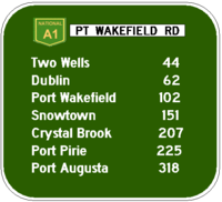
The list of towns on or near the road include:
- VirginiaVirginia, South AustraliaVirginia is a suburb on the rural outskirts of Adelaide, the capital city of South Australia. Port Wakefield Road, the main highway taking traffic to the north of Adelaide, passes through the area. Market gardening is the main activity there.-References:...
- Two WellsTwo Wells, South AustraliaTwo Wells is a town approximately 40km north of Adelaide South Australia. The first settlers in the area used two aboriginal wells in the area as a freshwater source. The town was officially named on 21 June 1990...
- Lower Light
- DublinDublin, South AustraliaDublin is a small town on the Adelaide Plains in South Australia, north of the state capital, Adelaide. Situated on Highway 1, the town is surrounded by farmland and rural industry. Along with nearby Windsor the area is home to a growing commuter population...
- Port WakefieldPort Wakefield, South AustraliaPort Wakefield was the first government town to be established north of the capital, Adelaide, in South Australia.Port Wakefield is situated approximately 98.7 kilometres from Adelaide and lies on the Port Wakefield Road section of the A1 National Highway...
- Windsor
See also
- Highways in AustraliaHighways in AustraliaThis is a list of highways in Australia, listed alphabetically along with each highway's route number and location. Note that some highways service more than one state or territory.-Route numbering systems:...
- List of highways in South Australia
- Highway 1 (Australia)Highway 1 (Australia)Australia's Highway 1 is a network of highways that circumnavigate the Australian continent, joining all mainland state capitals. At a total length of approximately it is the longest national highway in the world, longer than the Trans-Siberian Highway and the Trans-Canada Highway...
- A1 highway (South Australia)A1 highway (South Australia)The A1 highway, also variously known as National Route 1, National Highway 1, and other names, circumnavigates Australia, mainly following the coastline, connecting all of the mainland state capitals. Refer to Highway 1 for details....