

Flinders Highway, Queensland
Encyclopedia
Flinders Highway is a highway that crosses Queensland
from east to west, from Townsville on the Pacific coast to Cloncurry (Barkly Highway
continues from Cloncurry to the Northern Territory
border at Camooweal
and beyond). Flinders Highway and passes a number of small outback
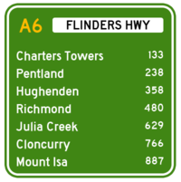
towns. Typical outback landscape predominates towards the inland. Formerly National Route 78, Queensland began to convert to the alphanumeric system much of Australia had adopted in the early-2000s and is now designated as A6. Flinders Highway is also known as Overlander's Way. It's entire length is part of the National Land Transport Network (formerly Auslink).
flights started between here and Charleville in 1922 and Royal Flying Doctor Service of Australia
service started here in 1928. It is nowadays an important road and rail junction. Flinders Highway ends here.
Queensland
Queensland is a state of Australia, occupying the north-eastern section of the mainland continent. It is bordered by the Northern Territory, South Australia and New South Wales to the west, south-west and south respectively. To the east, Queensland is bordered by the Coral Sea and Pacific Ocean...
from east to west, from Townsville on the Pacific coast to Cloncurry (Barkly Highway
Barkly Highway
The Barkly Highway is a national highway of both Queensland and the Northern Territory.-Description:It runs westward from Cloncurry and the junctions of the Flinders and Landsborough highways to the junction with the Stuart Highway north of Tennant Creek...
continues from Cloncurry to the Northern Territory
Northern Territory
The Northern Territory is a federal territory of Australia, occupying much of the centre of the mainland continent, as well as the central northern regions...
border at Camooweal
Camooweal, Queensland
Camooweal is a small town in north-western Queensland, Australia, located 188 km north-west of the city of Mount Isa and 12 km east of the Northern Territory border. Local government is provided by the Mount Isa City Council. The town lies on the Barkly Highway, and is adjacent to the Georgina River...
and beyond). Flinders Highway and passes a number of small outback
Outback
The Outback is the vast, remote, arid area of Australia, term colloquially can refer to any lands outside the main urban areas. The term "the outback" is generally used to refer to locations that are comparatively more remote than those areas named "the bush".-Overview:The outback is home to a...
towns. Typical outback landscape predominates towards the inland. Formerly National Route 78, Queensland began to convert to the alphanumeric system much of Australia had adopted in the early-2000s and is now designated as A6. Flinders Highway is also known as Overlander's Way. It's entire length is part of the National Land Transport Network (formerly Auslink).
Charters Towers
133 km to the south west from Townsville. A former gold rush town with a population of 30 000 in 1890. At that time it was known as "The World" because it seemed to be the centre of everything. Presently it is centre for cattle grazing, with gold mining continuing to be an important industry. Much of the elegant gold rush architecture of the nineteenth remains in place and is a tourist attraction.Hughenden
Located 243 km further on, Hughenden, the administrative centre of Flinders shire is in the heart of sheep and cattle country.Richmond
A former gold rush town located 112 km further west. Currently a pastoral centre.Cloncurry
A former copper-mining town located 139 km west from Julia Creek. The first regular QantasQantas
Qantas Airways Limited is the flag carrier of Australia. The name was originally "QANTAS", an initialism for "Queensland and Northern Territory Aerial Services". Nicknamed "The Flying Kangaroo", the airline is based in Sydney, with its main hub at Sydney Airport...
flights started between here and Charleville in 1922 and Royal Flying Doctor Service of Australia
Royal Flying Doctor Service of Australia
The Royal Flying Doctor Service of Australia is an emergency and primary health care service for those living in rural, remote and regional areas of Australia...
service started here in 1928. It is nowadays an important road and rail junction. Flinders Highway ends here.
External links
- Overlander's Highway A driving guide by Roderick Eime