
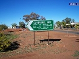
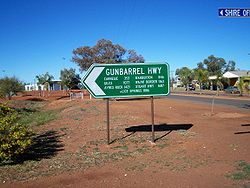
Gunbarrel Highway
Encyclopedia
Northern Territory
The Northern Territory is a federal territory of Australia, occupying much of the centre of the mainland continent, as well as the central northern regions...
, South Australia
South Australia
South Australia is a state of Australia in the southern central part of the country. It covers some of the most arid parts of the continent; with a total land area of , it is the fourth largest of Australia's six states and two territories.South Australia shares borders with all of the mainland...
and Western Australia
Western Australia
Western Australia is a state of Australia, occupying the entire western third of the Australian continent. It is bounded by the Indian Ocean to the north and west, the Great Australian Bight and Indian Ocean to the south, the Northern Territory to the north-east and South Australia to the south-east...
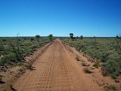
. It consists of about 1400 km (869.9 mi) of washaways, heavy corrugations, stone, sand and flood plains. The Gunbarrel Highway connects Victory Downs, just north of the Northern Territory/South Australia border to Carnegie Station in Western Australia (this is the direction the road was constructed). Some sources also incorrectly show the highway extending west to Wiluna
Wiluna, Western Australia
Wiluna is a complex town in the Mid West region of Western Australia. It is situated on the edge of the Western Desert at the gateway to the Canning Stock Route and Gunbarrel Highway. It is the service centre of the local area for the local Aboriginal people, the pastoral industry, mining, and...
.
The route passes directly into Aboriginal Reserves and it is a legal requirement for travellers to hold a valid Transit Permit at the time of travel. Three permits are required and they are available from the Department of Indigenous Affairs. The permits are free. Some of the eastern section of the road is now named the Tjukaruru Road for the Aboriginal people who live in this area.
The Gunbarrel Highway was built as part of Australia's role in the weapons research establishment called Woomera
Woomera, South Australia
The town, or village, of Woomera is located in the south east corner of the Woomera Prohibited Area ; colloquially known as the Woomera Rocket Range...
which included Emu Field
Emu Field
Emu Field is located in the desert of South Australia, at . Variously known as Emu Field, Emu Junction or Emu, it was the site of the Operation Totem pair of nuclear tests conducted by the British government in October 1953.The site was surveyed by Len Beadell in 1952...
and Maralinga
Maralinga, South Australia
Maralinga, South Australia in the remote western areas of South Australia was the home of the Maralinga Tjarutja, a southern Pitjantjatjara Indigenous Australian people. Maralinga was the site of the secret British nuclear tests in the 1950s. The site measures about 3,300 km² in area...
, both atomic bomb testing sites. Construction began in 1955 and was finally completed on 15 November 1958 when the road reached Carnegie.
The highway was surveyed and constructed under the direction of legendary bushman Len Beadell
Len Beadell
Leonard Beadell OAM BEM FIEMS was a surveyor, roadbuilder , bushman, artist and author, responsible for opening up the last remaining isolated desert areas of central Australia from 1947 to 1963. Len is sometimes called "the last true Australian explorer"...
, who was responsible for numerous other roads in Australia that opened up some of the most remote desert areas of the continent in the 1950s and 1960s. Its name comes from Beadell's Gunbarrel Road Construction Party so named as his intention was to build roads as straight as a gunbarrel. This was only sporadically achieved however, due to the nature and variety of terrain through which the roads passed.
By any standard, this is a long and tough haul through very remote territory. Its isolation requires travellers to be totally self-sufficient with water, food and fuel (the longest distance between fuel outlets is 489 km, between Warburton
Warburton, Western Australia
Warburton or Warburton Ranges is an Indigenous Australian community in Western Australia, just to the south of the Gibson Desert and located on the Great Central Road and Gunbarrel Highway...
and Carnegie Station.)
Part of the highway between Warburton and Warakurna (near Giles
Giles Weather Station
Giles Weather Station is located in Western Australia near the South Australian border, about West-South-West of Alice Springs and West of Uluru. It is the only staffed weather station within an area of about and is situated mid-continent and near the core of the subtropical jetstream...
) is now known as the Old Gunbarrel Highway, and is no longer maintained due to the construction of the more direct route, the Great Central Road
Great Central Road
The Great Central Road is a mostly unsealed Australian outback highway that runs 1126 km from Laverton, Western Australia to Yulara, Northern Territory ....
.
See also
- Highways in AustraliaHighways in AustraliaThis is a list of highways in Australia, listed alphabetically along with each highway's route number and location. Note that some highways service more than one state or territory.-Route numbering systems:...
- List of highways in the Northern Territory
- List of highways in South Australia
- List of highways in Western Australia