

Mitchell Highway
Encyclopedia
The Mitchell Highway is a major rural highway in Australia
, travelling through central and northern New South Wales
and south central Queensland
. The highway starts from its northern end in Queensland with the Landsborough Highway
near Augathella
and continues south to Charleville
and Cunnamulla
. It then crosses the border into New South Wales and passing through Bourke
, Byrock
, Nyngan
, Nevertire
, Narromine
, Dubbo, Wellington
, Molong
and Orange
. The highway ends at the junction of the Mid-Western Highway
to Cowra
and the Great Western Highway
to Sydney
via the Blue Mountains at Bathurst
.
The highway was declared on 8 August 1928 and named North Western Highway. On 9 October 1936 the name was changed to the Mitchell Highway, named after Major Thomas Mitchell, who was Surveyor-General of New South Wales
in the 1820s and explored much of inland New South Wales
and Victoria.
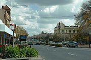 The portion of the Mitchell Highway passing through Orange, New South Wales, is known as Summer Street and serves as the main street through the city.
Australia
Australia , officially the Commonwealth of Australia, is a country in the Southern Hemisphere comprising the mainland of the Australian continent, the island of Tasmania, and numerous smaller islands in the Indian and Pacific Oceans. It is the world's sixth-largest country by total area...
, travelling through central and northern New South Wales
New South Wales
New South Wales is a state of :Australia, located in the east of the country. It is bordered by Queensland, Victoria and South Australia to the north, south and west respectively. To the east, the state is bordered by the Tasman Sea, which forms part of the Pacific Ocean. New South Wales...
and south central Queensland
Queensland
Queensland is a state of Australia, occupying the north-eastern section of the mainland continent. It is bordered by the Northern Territory, South Australia and New South Wales to the west, south-west and south respectively. To the east, Queensland is bordered by the Coral Sea and Pacific Ocean...
. The highway starts from its northern end in Queensland with the Landsborough Highway
Landsborough Highway
Landsborough Highway is a western Queensland highway running in the northwest-southeast direction from Morven to Cloncurry. The Landsborough Highway runs through vast tracts of land that was once occupied by William Landsborough, an Australian explorer of the 19th century...
near Augathella
Augathella, Queensland
Augathella is a town in western Queensland, Australia, and is part of the Murweh Shire. Augathella lies on the Matilda Highway, is north of the town of Charleville, and west of Brisbane . The town lies on the banks of the Warrego River...
and continues south to Charleville
Charleville, Queensland
Charleville is a town in south western Queensland, Australia, 758 kilometres by road west of Brisbane . It is the largest town and administrative centre of the Murweh Shire, which covers an area of 43,905 square kilometres...
and Cunnamulla
Cunnamulla, Queensland
Cunnamulla is a small town that lies on the Warrego River in south west Queensland, Australia, south of Charleville, and approximately west of the state capital, Brisbane....
. It then crosses the border into New South Wales and passing through Bourke
Bourke, New South Wales
-Transportation:Bourke can be reached by the Mitchell Highway, with additional sealed roads from town to the north , east and south . The town is also served by Bourke Airport and has Countrylink bus service to other regional centres, like Dubbo...
, Byrock
Byrock, New South Wales
Byrock is a small village in north western New South Wales, Australia in Bourke Shire. In 2006, Byrock had a population of 90 people.It is named after a rock hole, called Bai by the Nyammba tribe...
, Nyngan
Nyngan, New South Wales
Nyngan [pr: ning-g'n] is a town in the central west of New South Wales, Australia. It is located in the Bogan Shire Local Government Area. At the 2006 census, Nyngan had a population of 1,975 people. Nyngan is situated on the Bogan River between Narromine and Bourke, on the junction of the...
, Nevertire
Nevertire, New South Wales
Nevertire is a rural village in New South Wales, Australia. It is located at the junction of the Mitchell Highway and the Oxley Highway, in Warren Shire. Nevertire is about 525 kilometres northwest of Sydney, 68 km north-west of Narromine and about 90 km from Dubbo. It is about...
, Narromine
Narromine, New South Wales
Narromine is a town located about 40 kilometres west of Dubbo in the Orana region of New South Wales, Australia. It is the centre of Narromine Shire. At the 2006 census, Narromine had a population of 3,599 people...
, Dubbo, Wellington
Wellington, New South Wales
Wellington is a town in inland New South Wales, Australia located at the junction of the Macquarie and Bell Rivers. The town is the administrative centre of the Wellington Shire Local Government Area. The town is 362 kilometres from Sydney on the Great Western Highway and Mitchell Highway...
, Molong
Molong, New South Wales
Molong is a small town in the Central West region of New South Wales, Australia, in Cabonne Shire.Molong is located on the Mitchell Highway about 300 kilometres west of Sydney and about 30 kilometres from the city of Orange. It is elevated at 529 metres above sea level. At the 2006 census, Molong...
and Orange
Orange, New South Wales
Orange is a city in the Central West region of New South Wales, Australia. It is west of the state capital, Sydney, at an altitude of . Orange has an estimated population of 39,329 and the city is a major provincial centre....
. The highway ends at the junction of the Mid-Western Highway
Mid-Western Highway
The Mid-Western Highway starts at Bathurst New South Wales, where it joins with the Great Western Highway over the Blue Mountains from Sydney.It proceeds via Blayney, Carcoar and Cowra. It then heads west through Grenfell to West Wyalong where it crosses the Newell Highway...
to Cowra
Cowra, New South Wales
Cowra is a town in the Central West region of New South Wales, Australia in the Cowra Shire. It is located on the Mid-Western Highway, 317 kilometres west of Sydney on the banks of the Lachlan River at an altitude of 310 metres above sea level. At the 2006 census Cowra had a population of 8,430...
and the Great Western Highway
Great Western Highway
The Great Western Highway is a highway in New South Wales, Australia. It runs 210 km from Sydney to Bathurst.Starting as Broadway at the intersection of City Road near the fringe of the Sydney CBD, and becoming Parramatta Road to Parramatta itself, the Great Western Highway heads due west from...
to Sydney
Sydney
Sydney is the most populous city in Australia and the state capital of New South Wales. Sydney is located on Australia's south-east coast of the Tasman Sea. As of June 2010, the greater metropolitan area had an approximate population of 4.6 million people...
via the Blue Mountains at Bathurst
Bathurst, New South Wales
-CBD and suburbs:Bathurst's CBD is located on William, George, Howick, Russell, and Durham Streets. The CBD is approximately 25 hectares and surrounds two city blocks. Within this block layout is banking, government services, shopping centres, retail shops, a park* and monuments...
.
The highway was declared on 8 August 1928 and named North Western Highway. On 9 October 1936 the name was changed to the Mitchell Highway, named after Major Thomas Mitchell, who was Surveyor-General of New South Wales
New South Wales
New South Wales is a state of :Australia, located in the east of the country. It is bordered by Queensland, Victoria and South Australia to the north, south and west respectively. To the east, the state is bordered by the Tasman Sea, which forms part of the Pacific Ocean. New South Wales...
in the 1820s and explored much of inland New South Wales
New South Wales
New South Wales is a state of :Australia, located in the east of the country. It is bordered by Queensland, Victoria and South Australia to the north, south and west respectively. To the east, the state is bordered by the Tasman Sea, which forms part of the Pacific Ocean. New South Wales...
and Victoria.
See also
- Highways in AustraliaHighways in AustraliaThis is a list of highways in Australia, listed alphabetically along with each highway's route number and location. Note that some highways service more than one state or territory.-Route numbering systems:...
- Highways in New South Wales
- List of highways in Queensland