

Great Alpine Road
Encyclopedia
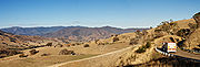
The Great Alpine Road is a country tourist road in Victoria
, Australia
, running from Wangaratta
in the north to Bairnsdale
in the east, and passing through the Australian Alps
. The road was given its current name as being the mountain equivalent to Victoria's world famous Great Ocean Road
in the south-west of the state.
rises to an altitude of 1840 m, is blanketed with snow during winter months and must be cleared on a daily basis. Extreme weather conditions can sometimes still result in the road being closed between Harrietville and Omeo.
The Great Alpine Road links Victoria's North East with Gippsland
. It was completed with the sealing of the section between Mount Hotham
and Dinner Plain
and was officially opened on 4 April 1998. The road itself has existed since colonial times in some form, but was unsealed for much of its history, and was only given the Great Alpine Road designation after being fully sealed.
The current Great Alpine Road includes the former Ovens Highway from Wangaratta to Bright
, and a former section of the Omeo Highway
from Omeo to Bruthen, along with the section of the Princes Highway
from Bruthen to Bairnsdale. Attractions include the Mount Buffalo National Park
, popular tourist town Bright
, the Mount Hotham
and Dinner Plain
alpine resorts, the historic gold rush township of Omeo, the folk art sculpture Mr. Stringy
, and stunning views and challenging driving along its length.
Victoria (Australia)
Victoria is the second most populous state in Australia. Geographically the smallest mainland state, Victoria is bordered by New South Wales, South Australia, and Tasmania on Boundary Islet to the north, west and south respectively....
, Australia
Australia
Australia , officially the Commonwealth of Australia, is a country in the Southern Hemisphere comprising the mainland of the Australian continent, the island of Tasmania, and numerous smaller islands in the Indian and Pacific Oceans. It is the world's sixth-largest country by total area...
, running from Wangaratta
Wangaratta, Victoria
Wangaratta is a cathedral city of almost 17,000 people in the northeast of Victoria, Australia, about from Melbourne along the Hume Highway, with Benalla to the southwest, and Albury-Wodonga to the northeast. It is located at the junction of the Ovens and King rivers which flow from the...
in the north to Bairnsdale
Bairnsdale, Victoria
Bairnsdale is a small city in Gippsland, Victoria, Australia. With a population at the 2006 census of 11,282, it is a major regional centre of eastern Victoria along with Traralgon and Sale....
in the east, and passing through the Australian Alps
Australian Alps
The Australian Alps are the highest mountain ranges of mainland Australia. They are located in southeastern Australia and straddle the Australian Capital Territory, south-eastern New South Wales and eastern Victoria...
. The road was given its current name as being the mountain equivalent to Victoria's world famous Great Ocean Road
Great Ocean Road
The Great Ocean Road is a stretch of road along the south-eastern coast of Australia between the Victorian cities of Torquay and Warrnambool. The road was built by returned soldiers between 1919 and 1932, and is the world's largest war memorial; dedicated to casualties of World War I...
in the south-west of the state.
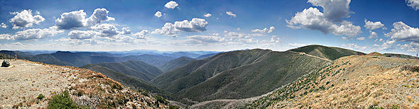
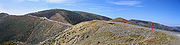
Route details
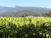
The Great Alpine Road winds through mountains, valleys and forests, and past rivers, vineyards and farms. At a length of 303 kilometres, it is Australia’s highest year-round accessible sealed road. The section over Mount HothamMount Hotham
Mount Hotham is a mountain in Victoria, Australia. It is home to Hotham Alpine Resort. The mountain is located approximately north east of Melbourne, from Sydney, and from Adelaide by road. Mt Hotham's summit rises to an altitude of above sea level...
rises to an altitude of 1840 m, is blanketed with snow during winter months and must be cleared on a daily basis. Extreme weather conditions can sometimes still result in the road being closed between Harrietville and Omeo.
The Great Alpine Road links Victoria's North East with Gippsland
Gippsland
Gippsland is a large rural region in Victoria, Australia. It begins immediately east of the suburbs of Melbourne and stretches to the New South Wales border, lying between the Great Dividing Range to the north and Bass Strait to the south...
. It was completed with the sealing of the section between Mount Hotham
Mount Hotham
Mount Hotham is a mountain in Victoria, Australia. It is home to Hotham Alpine Resort. The mountain is located approximately north east of Melbourne, from Sydney, and from Adelaide by road. Mt Hotham's summit rises to an altitude of above sea level...
and Dinner Plain
Dinner Plain, Victoria
Dinner Plain is a town in Victoria, Australia, located on the Great Alpine Road, 10 kilometres from Mount Hotham Alpine Resort, and 375 kilometres from Melbourne. At the 2006 census, Dinner Plain had a population of 88, yet has over 200 lodges and chalets for tourist accommodation...
and was officially opened on 4 April 1998. The road itself has existed since colonial times in some form, but was unsealed for much of its history, and was only given the Great Alpine Road designation after being fully sealed.
The current Great Alpine Road includes the former Ovens Highway from Wangaratta to Bright
Bright
Bright may refer to:*Brightness, the perception of how dark or light a source of luminance is*Being bright , describing colloquially, something with intelligence...
, and a former section of the Omeo Highway
Omeo Highway
The Omeo Highway is a 157 kilometre road in eastern Victoria, Australia, connecting north-east Victoria to Gippsland over parts of the Victorian Alps....
from Omeo to Bruthen, along with the section of the Princes Highway
Princes Highway
The Princes Highway extends from Sydney to Port Augusta via the coast through the states of New South Wales, Victoria and South Australia, a distance of 1941 km or 1898 km via the former alignments of the highway ....
from Bruthen to Bairnsdale. Attractions include the Mount Buffalo National Park
Mount Buffalo National Park
Mount Buffalo is a mountain plateau in Victoria , 200 km northeast of Melbourne. It is one of the oldest parks in the Australian Alps, being first established in 1898 when 1165 ha was reserved around Eurobin Falls...
, popular tourist town Bright
Bright, Victoria
Bright is a small sized town, located in northeastern Victoria, Australia, 319 metres above sea level at the southeastern end of the Ovens Valley. At the 2006 census, Bright had a population of 2684. It is in the Alpine Shire local government area...
, the Mount Hotham
Mount Hotham
Mount Hotham is a mountain in Victoria, Australia. It is home to Hotham Alpine Resort. The mountain is located approximately north east of Melbourne, from Sydney, and from Adelaide by road. Mt Hotham's summit rises to an altitude of above sea level...
and Dinner Plain
Dinner Plain, Victoria
Dinner Plain is a town in Victoria, Australia, located on the Great Alpine Road, 10 kilometres from Mount Hotham Alpine Resort, and 375 kilometres from Melbourne. At the 2006 census, Dinner Plain had a population of 88, yet has over 200 lodges and chalets for tourist accommodation...
alpine resorts, the historic gold rush township of Omeo, the folk art sculpture Mr. Stringy
Mr. Stringy
Mr. Stringy, also known as The Wooden Man or just The Man, is a folk art project and tourist attraction on the Great Alpine Road in East Gippsland, Victoria, Australia. Mr. Stringy is a sculpture in a human form, originally carved from a stringybark stump, which is regularly repainted into...
, and stunning views and challenging driving along its length.
Towns and resorts
| Location | Distance from Wangaratta (km) | Distance to next location (km) | Distance from Bairnsdale (km) | |
|---|---|---|---|---|
| Wangaratta Wangaratta, Victoria Wangaratta is a cathedral city of almost 17,000 people in the northeast of Victoria, Australia, about from Melbourne along the Hume Highway, with Benalla to the southwest, and Albury-Wodonga to the northeast. It is located at the junction of the Ovens and King rivers which flow from the... |
0 | 0 | 303 | |
| Myrtleford Myrtleford, Victoria Myrtleford is a town in north-east Victoria, Australia, 45 km south-east of Wangaratta and 275 km north-east of Melbourne. Myrtleford is part of the Alpine Shire local government area and at the 2006 census the town had a population of 3,187.... |
46 | 46 | 257 | |
| Ovens Ovens, Victoria Ovens is a small town in north east Victoria, Australia located at the junction of the Ovens River and Happy Valley Creek. At the 2006 census, Ovens and the surrounding area had a population of 130. It is south east of Myrtleford heading towards Bright and is the home of the Happy Valley Hotel... |
53 | 7 | 250 | |
| Bright Bright, Victoria Bright is a small sized town, located in northeastern Victoria, Australia, 319 metres above sea level at the southeastern end of the Ovens Valley. At the 2006 census, Bright had a population of 2684. It is in the Alpine Shire local government area... |
79 | 26 | 224 | |
| Harrietville | 105 | 26 | 198 | |
| Mount Hotham Mount Hotham Mount Hotham is a mountain in Victoria, Australia. It is home to Hotham Alpine Resort. The mountain is located approximately north east of Melbourne, from Sydney, and from Adelaide by road. Mt Hotham's summit rises to an altitude of above sea level... |
133 | 28 | 170 | |
| Dinner Plain Dinner Plain, Victoria Dinner Plain is a town in Victoria, Australia, located on the Great Alpine Road, 10 kilometres from Mount Hotham Alpine Resort, and 375 kilometres from Melbourne. At the 2006 census, Dinner Plain had a population of 88, yet has over 200 lodges and chalets for tourist accommodation... |
143 | 10 | 160 | |
| Omeo Omeo, Victoria Omeo is a town in Victoria, Australia, located on the Great Alpine Road, east of Mount Hotham, in the Shire of East Gippsland. At the 2006 census, Omeo had a population of 452. The name is derived from the Aboriginal word for 'mountains' or 'hills'... |
188 | 45 | 115 | |
| Swifts Creek Swifts Creek, Victoria Swifts Creek is a rural community located between Omeo and Ensay on the Great Alpine Road in East Gippsland, Victoria, Australia, east of the state capital Melbourne. Swifts Creek is at an altitude of 300 m above sea level. The area was originally settled by Europeans in the gold rushes of the mid... |
214 | 26 | 89 | |
| Ensay Ensay, Victoria Ensay is a small town located between Swifts Creek and Bruthen on the Great Alpine Road in East Gippsland, Victoria, Australia. Ensay is north of the major town of Bairnsdale and east of the state capital Melbourne... |
232 | 18 | 71 | |
| Bruthen Bruthen, Victoria Bruthen is a small town located alongside the Tambo River between Bairnsdale and Ensay on the Great Alpine Road in East Gippsland, Victoria, Australia. At the 2006 census, Bruthen had a population of 624... |
277 | 45 | 26 | |
| Bairnsdale Bairnsdale, Victoria Bairnsdale is a small city in Gippsland, Victoria, Australia. With a population at the 2006 census of 11,282, it is a major regional centre of eastern Victoria along with Traralgon and Sale.... |
303 | 26 | 0 | |
See also
- Highways in AustraliaHighways in AustraliaThis is a list of highways in Australia, listed alphabetically along with each highway's route number and location. Note that some highways service more than one state or territory.-Route numbering systems:...
- Highways in VictoriaHighways in VictoriaThe Highways in Victoria are the highest density in any state in Australia. Unlike Australia's other mainland states where vast areas are very sparsely inhabited "outback", there are population centres spread out over most of the state, with only the far north-west and the Victorian Alps lacking...