
Leach Highway
Encyclopedia
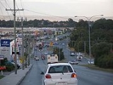
Leach Highway is a major dual carriageway
arterial road in Perth, Western Australia
, which varies between 4 and 6 lanes wide. The speed limit is either 70 or 80 km/h. It is located south of the Swan River
and links Fremantle
with Kewdale
, a distance of 23 kilometres (14.3 mi).
, and High Road in Canning (now Willetton)
.
It was soon extended eastward from High Road through to Manning Road, using the old timber Riverton Bridge
over Canning River
. In 1976 it was further extended from Manning Road to Orrong Road, including bridges over the Armadale line and Albany Highway
. Then in 1978 the 4-lane concrete Shelley Bridge over Canning River
opened, with Riverton Bridge retained for local traffic.
In the early 1980s the highway was extended further eastward to the new Beechboro-Gosnells Highway
which remains as the highway's present eastern terminus.
Also around that time a number of intersections were built to coincide with new roads being built around Leach Highway. A parclo interchange
was constructed at the newly extended Kwinana Freeway
, and an intersection was constructed for the new Centenary Avenue in Wilson
to improve access to the West Australian Institute of Technology. New at-grade intersections were built at Murdoch Drive and Winthrop Drive to service the new suburbs of Bateman
and Winthrop
.
Although not strictly Leach Highway, in 1985 Stirling Highway
was extended southwards from its then terminus at Canning Highway
to a new terminus at High Street (an extension of Leach Highway). This marked the final piece of an improved freight link between the Port of Fremantle and Perth's
major industrial areas around Kewdale
Then, apart from minor modifications, the highway remained largely unchanged until 2005/2006 when work on projects at Kwinana Freeway
and Orrong Road commenced.
, the road continues as High Street for a further 1.5 km. Here, it is a 4-lane undivided carriageway (speed limit 60 km/h) until the intersection at Stirling Highway
, whereafter it is a much smaller local road. The T junction at Stirling Highway
is part of the main freight access for vehicles accessing the Port of Fremantle, and is a very busy intersection for trucks.
/Welshpool
with Western Australia's
major container port at Fremantle
. The highway was constructed in the 1970s to provide, in conjunction with Roe Highway
, good heavy vehicle access along this route.
However, due to planning limitations arising from existing development, much of the route was not constructed as limited access, meaning driveways and a large number of side streets intersect Leach Highway. Along its length there are 22 sets of traffic signals
and some argue that there should be more. Such a design is undesirable for a predominantly 6-lane highway with large numbers of heavy vehicles.
With cancellation of Roe Highway stage 8
, Leach Highway seems likely to remain this way for the foreseeable future. However things may improve depending on the success of the state government's
6-point plan for moving freight into and out of the Port of Fremantle.
announced plans for the construction of a diamond interchange at the intersection of Leach Highway and Orrong Road in Welshpool
. Orrong Road, which is a continuation of Graham Farmer Freeway
has experienced increased in traffic by approximately 40% since the freeway was completed in 2000. The new bridge will bring Leach Highway over Orrong Road. The intersection was formerly Perth's
worst blackspot. Approximately 70,000 vehicles, including substantial numbers of trucks, use the intersection daily. Funding for the project was made available through the sale of land reserved for the Fremantle Eastern Bypass
. The interchange has since been completed and traffic flow has improved vastly.
for the new Perth-Mandurah railway. A new bridge was built immediately south of the present highway bridge to cater for bus access to the railway station. Alterations to the Kwinana Freeway
on and off ramps to Leach Highway have also been undertaken, entailing modifications to the layout of the parclo interchange
.
3rd and 4th worst unfunded blackspots are located on Leach Highway, at the intersections of Tonkin Highway
and Welshpool Road respectively.
and Orrong Road interchanges are grade separated, in favour of Leach Highway.
Signed as :
:
Signed as  :
:
Signed as
Leach Highway then continues as High Street
Dual carriageway
A dual carriageway is a class of highway with two carriageways for traffic travelling in opposite directions separated by a central reservation...
arterial road in Perth, Western Australia
Perth, Western Australia
Perth is the capital and largest city of the Australian state of Western Australia and the fourth most populous city in Australia. The Perth metropolitan area has an estimated population of almost 1,700,000....
, which varies between 4 and 6 lanes wide. The speed limit is either 70 or 80 km/h. It is located south of the Swan River
Swan River (Western Australia)
The Swan River estuary flows through the city of Perth, in the south west of Western Australia. Its lower reaches are relatively wide and deep, with few constrictions, while the upper reaches are usually quite narrow and shallow....
and links Fremantle
Fremantle
Freemantle is a suburb of Southampton in England.Fremantle or Freemantle may also refer to:- Places :* Fremantle, the port city to the capital Perth, Western Australia...
with Kewdale
Kewdale, Western Australia
Kewdale is a suburb of Perth, Western Australia, located within the City of Belmont. Kew Street was one of the first roads in this district, hence the naming of the suburb....
, a distance of 23 kilometres (14.3 mi).
History
Leach Highway is named for J.D. "Digby" Leach, former Commissioner of Main Roads Western Australia. In 1972 the first section was opened between its present western terminus at Carrington Street, Melville (now Palmyra)Palmyra, Western Australia
Palmyra is a suburb of Perth, Western Australia, located within the City of Melville.It was the home of Catherine Helen Spence, the first Australian woman to become a political candidate after standing for the Federal Convention in Adelaide....
, and High Road in Canning (now Willetton)
Willetton, Western Australia
Willetton is a large southern suburb of Perth, Western Australia. Its Local Government Area is the City of Canning.-History:Willetton's name derives from Henry Willett of Willett & Co, who was granted Canning Location 21 and settled in the area in June 1832...
.
It was soon extended eastward from High Road through to Manning Road, using the old timber Riverton Bridge
Riverton Bridge
Riverton Bridge is a small, two lane timber road traffic bridge spanning the Canning River at Riverton, in Perth, Western AustraliaIt was originally built in 1911 and known as the Watts Road Bridge, being renamed to Riverton Bridge in 1916. By the 1930s the bridge had fallen into disrepair. In 1954...
over Canning River
Canning River (Western Australia)
The Canning River is a major tributary of the Swan River in south western Western Australia.-Source and route:With headwaters on the Darling Scarp, the Canning meanders through suburbs of Perth on the Swan Coastal Plain, including Cannington, Thornlie, Riverton, Shelley, Rossmoyne and Mount...
. In 1976 it was further extended from Manning Road to Orrong Road, including bridges over the Armadale line and Albany Highway
Albany Highway
Albany Highway is a generally northwest-southeast highway in the south of Western Australia which links the state's capital Perth with its oldest settlement, Albany. The highway is approximately in length, is designated State Route 30 and separates Western Australia's Great Southern region from...
. Then in 1978 the 4-lane concrete Shelley Bridge over Canning River
Canning River (Western Australia)
The Canning River is a major tributary of the Swan River in south western Western Australia.-Source and route:With headwaters on the Darling Scarp, the Canning meanders through suburbs of Perth on the Swan Coastal Plain, including Cannington, Thornlie, Riverton, Shelley, Rossmoyne and Mount...
opened, with Riverton Bridge retained for local traffic.
In the early 1980s the highway was extended further eastward to the new Beechboro-Gosnells Highway
Tonkin Highway
Tonkin Highway, at , is a limited access dual carriageway in Perth, Western Australia, connecting Reid Highway in the north with Thomas Road in the south. Mostly a 4 lane highway, some sections of the highway are to a 4 to 6 lane freeway standard; the remainder of the highway has been designed to...
which remains as the highway's present eastern terminus.
Also around that time a number of intersections were built to coincide with new roads being built around Leach Highway. A parclo interchange
Parclo interchange
A partial cloverleaf interchange or parclo is a modification of a cloverleaf interchange. The parclo interchange was developed by the Ontario Ministry of Transportation as a replacement for the cloverleaf on 400-Series Highways, removing the dangerous weaving patterns and allowing for more...
was constructed at the newly extended Kwinana Freeway
Kwinana Freeway
The Kwinana Freeway is a major arterial road in Perth, Western Australia, linking Perth with the southern suburbs and then further on towards Mandurah, a distance of . It has a speed limit of , except in central Perth and south of Lakes Road . Like all Western Australian freeways, the minimum...
, and an intersection was constructed for the new Centenary Avenue in Wilson
Wilson, Western Australia
Wilson is a suburb of Perth, Western Australia, located within the City of Canning on the north bank of the Canning River....
to improve access to the West Australian Institute of Technology. New at-grade intersections were built at Murdoch Drive and Winthrop Drive to service the new suburbs of Bateman
Bateman, Western Australia
Bateman is a suburb of Perth, Western Australia, located within the City of Melville.It is a mostly residential suburb with convenient road access to Perth City, Fremantle, the main industrial sites and airports. Bull Creek railway station is located at its north-eastern corner...
and Winthrop
Winthrop, Western Australia
Winthrop is a southern suburb of Perth, Western Australia, located within the City of Melville.-History:Winthrop was originally a pine tree plantation owned by the University of Western Australia. The first blocks were sold in the early 1980s. After the first residents moved in, more blocks were...
.
Although not strictly Leach Highway, in 1985 Stirling Highway
Stirling Highway
Stirling Highway is, for most of its length, a four-lane single carriageway and major arterial road between Perth, Western Australia and the port city of Fremantle in Western Australia on the northern side of the Swan River. The speed limit is 60 km/h...
was extended southwards from its then terminus at Canning Highway
Canning Highway
Canning Highway is a mostly 4 lane single carriageway major arterial road in Perth, Western Australia. The speed limit is 60 km/h. It is located south of the Swan River and links Perth with Fremantle, running between The Causeway in Victoria Park and Queen Victoria Street in...
to a new terminus at High Street (an extension of Leach Highway). This marked the final piece of an improved freight link between the Port of Fremantle and Perth's
Perth, Western Australia
Perth is the capital and largest city of the Australian state of Western Australia and the fourth most populous city in Australia. The Perth metropolitan area has an estimated population of almost 1,700,000....
major industrial areas around Kewdale
Kewdale, Western Australia
Kewdale is a suburb of Perth, Western Australia, located within the City of Belmont. Kew Street was one of the first roads in this district, hence the naming of the suburb....
Then, apart from minor modifications, the highway remained largely unchanged until 2005/2006 when work on projects at Kwinana Freeway
Kwinana Freeway
The Kwinana Freeway is a major arterial road in Perth, Western Australia, linking Perth with the southern suburbs and then further on towards Mandurah, a distance of . It has a speed limit of , except in central Perth and south of Lakes Road . Like all Western Australian freeways, the minimum...
and Orrong Road commenced.
High Street, Fremantle
Although Leach Highway's western terminus as a 6-lane divided carriageway is at Carrington Street in PalmyraPalmyra, Western Australia
Palmyra is a suburb of Perth, Western Australia, located within the City of Melville.It was the home of Catherine Helen Spence, the first Australian woman to become a political candidate after standing for the Federal Convention in Adelaide....
, the road continues as High Street for a further 1.5 km. Here, it is a 4-lane undivided carriageway (speed limit 60 km/h) until the intersection at Stirling Highway
Stirling Highway
Stirling Highway is, for most of its length, a four-lane single carriageway and major arterial road between Perth, Western Australia and the port city of Fremantle in Western Australia on the northern side of the Swan River. The speed limit is 60 km/h...
, whereafter it is a much smaller local road. The T junction at Stirling Highway
Stirling Highway
Stirling Highway is, for most of its length, a four-lane single carriageway and major arterial road between Perth, Western Australia and the port city of Fremantle in Western Australia on the northern side of the Swan River. The speed limit is 60 km/h...
is part of the main freight access for vehicles accessing the Port of Fremantle, and is a very busy intersection for trucks.
Heavy vehicles
Leach Highway is one of the state's most important heavy vehicle routes, linking the major industrial areas of KewdaleKewdale, Western Australia
Kewdale is a suburb of Perth, Western Australia, located within the City of Belmont. Kew Street was one of the first roads in this district, hence the naming of the suburb....
/Welshpool
Welshpool, Western Australia
Welshpool is an inner southeastern suburb of Perth, located mostly within the City of Canning. The area is considered to be one of the main industrial areas of Perth, along with Kewdale, Kwinana, Henderson, Malaga, O'Connor, Canning Vale and Osborne Park....
with Western Australia's
Western Australia
Western Australia is a state of Australia, occupying the entire western third of the Australian continent. It is bounded by the Indian Ocean to the north and west, the Great Australian Bight and Indian Ocean to the south, the Northern Territory to the north-east and South Australia to the south-east...
major container port at Fremantle
Fremantle
Freemantle is a suburb of Southampton in England.Fremantle or Freemantle may also refer to:- Places :* Fremantle, the port city to the capital Perth, Western Australia...
. The highway was constructed in the 1970s to provide, in conjunction with Roe Highway
Roe Highway
Roe Highway is a limited access dual carriageway in Western Australia. It links Great Northern Highway and Middle Swan Road with Kwinana Freeway. It is one of the key heavy vehicle routes in the Perth metropolitan area. Aside from intersections, the speed limit is 100 km/h for most of its length...
, good heavy vehicle access along this route.
However, due to planning limitations arising from existing development, much of the route was not constructed as limited access, meaning driveways and a large number of side streets intersect Leach Highway. Along its length there are 22 sets of traffic signals
Traffic light
Traffic lights, which may also be known as stoplights, traffic lamps, traffic signals, signal lights, robots or semaphore, are signalling devices positioned at road intersections, pedestrian crossings and other locations to control competing flows of traffic...
and some argue that there should be more. Such a design is undesirable for a predominantly 6-lane highway with large numbers of heavy vehicles.
With cancellation of Roe Highway stage 8
Roe Highway
Roe Highway is a limited access dual carriageway in Western Australia. It links Great Northern Highway and Middle Swan Road with Kwinana Freeway. It is one of the key heavy vehicle routes in the Perth metropolitan area. Aside from intersections, the speed limit is 100 km/h for most of its length...
, Leach Highway seems likely to remain this way for the foreseeable future. However things may improve depending on the success of the state government's
Government of Western Australia
The formation of the Government of Western Australia is prescribed in its Constitution, which dates from 1890, although it has been amended many times since then...
6-point plan for moving freight into and out of the Port of Fremantle.
Orrong Road interchange
In November 2005, the state governmentGovernment of Western Australia
The formation of the Government of Western Australia is prescribed in its Constitution, which dates from 1890, although it has been amended many times since then...
announced plans for the construction of a diamond interchange at the intersection of Leach Highway and Orrong Road in Welshpool
Welshpool, Western Australia
Welshpool is an inner southeastern suburb of Perth, located mostly within the City of Canning. The area is considered to be one of the main industrial areas of Perth, along with Kewdale, Kwinana, Henderson, Malaga, O'Connor, Canning Vale and Osborne Park....
. Orrong Road, which is a continuation of Graham Farmer Freeway
Graham Farmer Freeway
The Graham Farmer Freeway is a major part of the metropolitan road infrastructure in Perth, Western Australia. It is long and links Rivervale and East Perth with West Perth, bypassing Perth's central business district...
has experienced increased in traffic by approximately 40% since the freeway was completed in 2000. The new bridge will bring Leach Highway over Orrong Road. The intersection was formerly Perth's
Perth, Western Australia
Perth is the capital and largest city of the Australian state of Western Australia and the fourth most populous city in Australia. The Perth metropolitan area has an estimated population of almost 1,700,000....
worst blackspot. Approximately 70,000 vehicles, including substantial numbers of trucks, use the intersection daily. Funding for the project was made available through the sale of land reserved for the Fremantle Eastern Bypass
Roe Highway
Roe Highway is a limited access dual carriageway in Western Australia. It links Great Northern Highway and Middle Swan Road with Kwinana Freeway. It is one of the key heavy vehicle routes in the Perth metropolitan area. Aside from intersections, the speed limit is 100 km/h for most of its length...
. The interchange has since been completed and traffic flow has improved vastly.
Bull Creek railway station
Bull Creek railway station was built at the interchange of Leach Highway and Kwinana FreewayKwinana Freeway
The Kwinana Freeway is a major arterial road in Perth, Western Australia, linking Perth with the southern suburbs and then further on towards Mandurah, a distance of . It has a speed limit of , except in central Perth and south of Lakes Road . Like all Western Australian freeways, the minimum...
for the new Perth-Mandurah railway. A new bridge was built immediately south of the present highway bridge to cater for bus access to the railway station. Alterations to the Kwinana Freeway
Kwinana Freeway
The Kwinana Freeway is a major arterial road in Perth, Western Australia, linking Perth with the southern suburbs and then further on towards Mandurah, a distance of . It has a speed limit of , except in central Perth and south of Lakes Road . Like all Western Australian freeways, the minimum...
on and off ramps to Leach Highway have also been undertaken, entailing modifications to the layout of the parclo interchange
Parclo interchange
A partial cloverleaf interchange or parclo is a modification of a cloverleaf interchange. The parclo interchange was developed by the Ontario Ministry of Transportation as a replacement for the cloverleaf on 400-Series Highways, removing the dangerous weaving patterns and allowing for more...
.
Blackspots
Perth'sPerth, Western Australia
Perth is the capital and largest city of the Australian state of Western Australia and the fourth most populous city in Australia. The Perth metropolitan area has an estimated population of almost 1,700,000....
3rd and 4th worst unfunded blackspots are located on Leach Highway, at the intersections of Tonkin Highway
Tonkin Highway
Tonkin Highway, at , is a limited access dual carriageway in Perth, Western Australia, connecting Reid Highway in the north with Thomas Road in the south. Mostly a 4 lane highway, some sections of the highway are to a 4 to 6 lane freeway standard; the remainder of the highway has been designed to...
and Welshpool Road respectively.
Major interchanges and exits
As Leach Highway is not limited access, a large number of the roads that Leach Highway are connected to are not controlled. Major intersections are at-grade and controlled. The Albany HighwayAlbany Highway
Albany Highway is a generally northwest-southeast highway in the south of Western Australia which links the state's capital Perth with its oldest settlement, Albany. The highway is approximately in length, is designated State Route 30 and separates Western Australia's Great Southern region from...
and Orrong Road interchanges are grade separated, in favour of Leach Highway.
Signed as
:
 Tonkin HighwayTonkin HighwayTonkin Highway, at , is a limited access dual carriageway in Perth, Western Australia, connecting Reid Highway in the north with Thomas Road in the south. Mostly a 4 lane highway, some sections of the highway are to a 4 to 6 lane freeway standard; the remainder of the highway has been designed to...
, KewdaleKewdale, Western AustraliaKewdale is a suburb of Perth, Western Australia, located within the City of Belmont. Kew Street was one of the first roads in this district, hence the naming of the suburb....
and CloverdaleCloverdale, Western AustraliaCloverdale is a suburb of Perth, the capital city of Western Australia, and is located east of Perth's central business district in the City of Belmont.-History:... Abernethy Road, KewdaleKewdale, Western AustraliaKewdale is a suburb of Perth, Western Australia, located within the City of Belmont. Kew Street was one of the first roads in this district, hence the naming of the suburb....
and CloverdaleCloverdale, Western AustraliaCloverdale is a suburb of Perth, the capital city of Western Australia, and is located east of Perth's central business district in the City of Belmont.-History:... Orrong Road, KewdaleKewdale, Western AustraliaKewdale is a suburb of Perth, Western Australia, located within the City of Belmont. Kew Street was one of the first roads in this district, hence the naming of the suburb....
, CarlisleCarlisle, Western AustraliaCarlisle is a suburb of Perth, Western Australia. Its Local Government Area is the Town of Victoria Park.- History :The suburb known as Carlisle today was originally settled as part of a land allocation to early Western Australian settlers after 1829...
, and WelshpoolWelshpool, Western AustraliaWelshpool is an inner southeastern suburb of Perth, located mostly within the City of Canning. The area is considered to be one of the main industrial areas of Perth, along with Kewdale, Kwinana, Henderson, Malaga, O'Connor, Canning Vale and Osborne Park....- Welshpool Road, WelshpoolWelshpool, Western AustraliaWelshpool is an inner southeastern suburb of Perth, located mostly within the City of Canning. The area is considered to be one of the main industrial areas of Perth, along with Kewdale, Kwinana, Henderson, Malaga, O'Connor, Canning Vale and Osborne Park....
 Albany HighwayAlbany HighwayAlbany Highway is a generally northwest-southeast highway in the south of Western Australia which links the state's capital Perth with its oldest settlement, Albany. The highway is approximately in length, is designated State Route 30 and separates Western Australia's Great Southern region from...
, BentleyBentley, Western AustraliaBentley is a southern suburb of Perth, the capital city of Western Australia, and is located 8 km southeast of Perth's central business district. Its Local Government Areas are the City of Canning and the Town of Victoria Park... Manning Road, BentleyBentley, Western AustraliaBentley is a southern suburb of Perth, the capital city of Western Australia, and is located 8 km southeast of Perth's central business district. Its Local Government Areas are the City of Canning and the Town of Victoria Park...
- Bungaree Road, WilsonWilson, Western AustraliaWilson is a suburb of Perth, Western Australia, located within the City of Canning on the north bank of the Canning River....
- Centenary Avenue, WilsonWilson, Western AustraliaWilson is a suburb of Perth, Western Australia, located within the City of Canning on the north bank of the Canning River....
- Vahland Avenue/Barbican Street East, ShelleyShelley, Western AustraliaShelley is a suburb of Perth, Western Australia, located within the City of Canning.-Education:Shelley has one primary school located within its borders. The first is Shelley Primary School which is off Monota Avenue...
 High RoadHigh Road, PerthHigh Road is a major road running through Parkwood, Riverton, Lynwood, Ferndale and Willetton in the south-east of Perth, Western Australia. It connects the major roads Leach Highway, and Albany Highway via Nicholson Road, originally built to provide Gosnells area with direct access to the port...
, ShelleyShelley, Western AustraliaShelley is a suburb of Perth, Western Australia, located within the City of Canning.-Education:Shelley has one primary school located within its borders. The first is Shelley Primary School which is off Monota Avenue...
, RivertonRiverton, Western AustraliaRiverton is a suburb of Perth in Western Australia.-Location:Riverton is situated about 14 km or 15 minutes from Perth. The Canning River makes some of its north eastern boundary. It is part of the City of Canning, situated south east of the Swan River...
and WillettonWilletton, Western AustraliaWilletton is a large southern suburb of Perth, Western Australia. Its Local Government Area is the City of Canning.-History:Willetton's name derives from Henry Willett of Willett & Co, who was granted Canning Location 21 and settled in the area in June 1832...- Karel Avenue, RossmoyneRossmoyne, Western AustraliaRossmoyne is a suburb of Perth, Western Australia, within the City of Canning. Rossmoyne is located south of central Perth, and is bounded by Leach Highway to the south, the Bull Creek to the west, the Canning River to the north, and Shelley to the east....
and WillettonWilletton, Western AustraliaWilletton is a large southern suburb of Perth, Western Australia. Its Local Government Area is the City of Canning.-History:Willetton's name derives from Henry Willett of Willett & Co, who was granted Canning Location 21 and settled in the area in June 1832... - Webb Street, RossmoyneRossmoyne, Western AustraliaRossmoyne is a suburb of Perth, Western Australia, within the City of Canning. Rossmoyne is located south of central Perth, and is bounded by Leach Highway to the south, the Bull Creek to the west, the Canning River to the north, and Shelley to the east....
- Bull Creek Drive, Bull CreekBull Creek, Western AustraliaBull Creek is a suburb of Perth, Western Australia, located within the local government area of City of Melville.-History:The name was adopted by the City of Melville Council in December 1968. The creek was named after an early settler, Lt Henry Bull to whom a grant of 1.20 km² of nearby land...
 Kwinana FreewayKwinana FreewayThe Kwinana Freeway is a major arterial road in Perth, Western Australia, linking Perth with the southern suburbs and then further on towards Mandurah, a distance of . It has a speed limit of , except in central Perth and south of Lakes Road . Like all Western Australian freeways, the minimum...
, BrentwoodBrentwood, Western AustraliaBrentwood is a suburb of Perth, Western Australia, located within the City of Melville.It is named for Brentwood, an English town near London which was the birthplace of John Bateman, a pioneer settler in the area....
and Bull CreekBull Creek, Western AustraliaBull Creek is a suburb of Perth, Western Australia, located within the local government area of City of Melville.-History:The name was adopted by the City of Melville Council in December 1968. The creek was named after an early settler, Lt Henry Bull to whom a grant of 1.20 km² of nearby land...
Signed as
:
- Moolyeen Road, BrentwoodBrentwood, Western AustraliaBrentwood is a suburb of Perth, Western Australia, located within the City of Melville.It is named for Brentwood, an English town near London which was the birthplace of John Bateman, a pioneer settler in the area....
- Murdoch Drive, BatemanBateman, Western AustraliaBateman is a suburb of Perth, Western Australia, located within the City of Melville.It is a mostly residential suburb with convenient road access to Perth City, Fremantle, the main industrial sites and airports. Bull Creek railway station is located at its north-eastern corner...
and WinthropWinthrop, Western AustraliaWinthrop is a southern suburb of Perth, Western Australia, located within the City of Melville.-History:Winthrop was originally a pine tree plantation owned by the University of Western Australia. The first blocks were sold in the early 1980s. After the first residents moved in, more blocks were... - Riseley Street, BoorogoonBooragoon, Western AustraliaBooragoon is a suburb of Perth, Western Australia located within the City of Melville.Booragoon is the aboriginal name for the lower reaches of the Canning River....
- North Lake Road, MyareeMyaree, Western AustraliaMyaree is a suburb of Perth, Western Australia, located within the City of Melville. Myaree gets its name from an Aboriginal word meaning foliage....
, WillageeWillagee, Western AustraliaWillagee is a suburb of Perth, Western Australia, located south-southwest of the Perth central business district. It is located in the Local Government Area of City of Melville, and the electoral district of Willagee, which takes its name from the suburb....
and WinthropWinthrop, Western AustraliaWinthrop is a southern suburb of Perth, Western Australia, located within the City of Melville.-History:Winthrop was originally a pine tree plantation owned by the University of Western Australia. The first blocks were sold in the early 1980s. After the first residents moved in, more blocks were... - Stock Road, MelvilleMelville, Western AustraliaMelville is a suburb of Perth, Western Australia located within the likewise named City of Melville....
, PalmyraPalmyra, Western AustraliaPalmyra is a suburb of Perth, Western Australia, located within the City of Melville.It was the home of Catherine Helen Spence, the first Australian woman to become a political candidate after standing for the Federal Convention in Adelaide....
, and WillageeWillagee, Western AustraliaWillagee is a suburb of Perth, Western Australia, located south-southwest of the Perth central business district. It is located in the Local Government Area of City of Melville, and the electoral district of Willagee, which takes its name from the suburb....
Signed as
- Carrington Street, PalmyraPalmyra, Western AustraliaPalmyra is a suburb of Perth, Western Australia, located within the City of Melville.It was the home of Catherine Helen Spence, the first Australian woman to become a political candidate after standing for the Federal Convention in Adelaide....
, and White Gum ValleyWhite Gum Valley, Western AustraliaWhite Gum Valley is a suburb of Perth, Western Australia, located within the City of Fremantle. It is situated behind the main ridge that lies east of Fremantle. White Gum Valley was formerly owned by the O'Hara Family in the early 1900s...
Leach Highway then continues as
High StreetSee also
- Highways in AustraliaHighways in AustraliaThis is a list of highways in Australia, listed alphabetically along with each highway's route number and location. Note that some highways service more than one state or territory.-Route numbering systems:...
- Highways in Western Australia
- Freeways in AustraliaFreeways in AustraliaThis is a list of freeways and motorways in Australia, sorted by states and territories and their corresponding routes. This list includes toll roads such as the CityLink freeway system in Melbourne. This list has over 70 entries...
- Freeways in Western Australia