
Irrigation Way
Encyclopedia
Murrumbidgee Irrigation Area
The Murrumbidgee Irrigation Area is geographically located within the Riverina area of New South Wales was created to control and divert the flow of local river and creek systems for the purpose of food production...
in south western New South Wales
New South Wales
New South Wales is a state of :Australia, located in the east of the country. It is bordered by Queensland, Victoria and South Australia to the north, south and west respectively. To the east, the state is bordered by the Tasman Sea, which forms part of the Pacific Ocean. New South Wales...
, Australia
Australia
Australia , officially the Commonwealth of Australia, is a country in the Southern Hemisphere comprising the mainland of the Australian continent, the island of Tasmania, and numerous smaller islands in the Indian and Pacific Oceans. It is the world's sixth-largest country by total area...
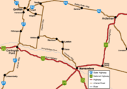
. Irrigation Way runs through three Local Government Area's. It begins at the town of Narrandera on the Newell Highway
Newell Highway
The Newell Highway is the longest highway in New South Wales, Australia. It runs parallel to the eastern coast about 400 kilometres inland, and is the main inland direct road link from Victoria to Queensland, bypassing the more congested coastal areas of New South Wales...
and runs 30 kilometres before reaching Leeton
Leeton, New South Wales
Leeton is a town in the Riverina region of New South Wales, Australia. Leeton is situated approximately 550 km west of Sydney and 450 km north of Melbourne in the productive Murrumbidgee Irrigation Area. Leeton is administered by Leeton Shire Council...
continuing another 55 kilometres before reaching Griffith
Griffith, New South Wales
Griffith is a city in south-western New South Wales, Australia. It is also the seat of the City of Griffith local government area. Like the Australian capital, Canberra and the nearby town of Leeton, Griffith was designed by Walter Burley Griffin. Griffith was named after Sir Arthur Griffith the...
. The town is an important link between the three towns as it is a very productive farming regions. The Irrigation Way provides a direct route between the national highway network and Griffith
Griffith, New South Wales
Griffith is a city in south-western New South Wales, Australia. It is also the seat of the City of Griffith local government area. Like the Australian capital, Canberra and the nearby town of Leeton, Griffith was designed by Walter Burley Griffin. Griffith was named after Sir Arthur Griffith the...
. The route is most important in linking Leeton
Leeton, New South Wales
Leeton is a town in the Riverina region of New South Wales, Australia. Leeton is situated approximately 550 km west of Sydney and 450 km north of Melbourne in the productive Murrumbidgee Irrigation Area. Leeton is administered by Leeton Shire Council...
to other regions of the state as it is the only major road passing through the town.
Towns
Narrandera: Irrigation Way begins off the Newell HighwayNewell Highway
The Newell Highway is the longest highway in New South Wales, Australia. It runs parallel to the eastern coast about 400 kilometres inland, and is the main inland direct road link from Victoria to Queensland, bypassing the more congested coastal areas of New South Wales...
near the bridge over the Murrumbidgee River
Murrumbidgee River
The Murrumbidgee River is a major river in the state of New South Wales, Australia, and the Australian Capital Territory . A major tributary of the Murray River, the Murrumbidgee flows in a west-northwesterly direction from the foot of Peppercorn Hill in the Fiery Range of the Snowy Mountains,...
and 2km from the junction with the Sturt Highway
Sturt Highway
The Sturt Highway is an Australian highway in New South Wales, Victoria, and South Australia. It is part of the Auslink National network and is part of the main highway route between Sydney and Adelaide.-Route:...
. The Narrandera Airport
Narrandera Airport
Narrandera Airport is a small regional airport in the local government area of Narrandera in the Riverina region of New South Wales, Australia. The airport is located approximately 10km from Narrandera along Irrigation Way...
is also located on the Irrigation Way, 10km from Narrandera. Irrigation Way reaches the Shire of Leeton
Leeton, New South Wales
Leeton is a town in the Riverina region of New South Wales, Australia. Leeton is situated approximately 550 km west of Sydney and 450 km north of Melbourne in the productive Murrumbidgee Irrigation Area. Leeton is administered by Leeton Shire Council...
shortly after the airport.
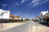
Leeton: Irrigation Way begins in the Leeton
Leeton
Leeton is the name of more than one place:*Leeton, Missouri, a town in the United States*Leeton, New South Wales, a town and Local Government Area of New South Wales, Australia...
Shire between Narrandera Airport
Narrandera Airport
Narrandera Airport is a small regional airport in the local government area of Narrandera in the Riverina region of New South Wales, Australia. The airport is located approximately 10km from Narrandera along Irrigation Way...
and the turn off to Rockdale Beef. After travelling approximately 18km the small village of Yanco is reached. The Yanco CBD is located on Irrigation Way as Main Street. Leeton
Leeton
Leeton is the name of more than one place:*Leeton, Missouri, a town in the United States*Leeton, New South Wales, a town and Local Government Area of New South Wales, Australia...
is located 3km from Yanco. Leeton
Leeton
Leeton is the name of more than one place:*Leeton, Missouri, a town in the United States*Leeton, New South Wales, a town and Local Government Area of New South Wales, Australia...
's CBD is also found on Irrigation Way. On the southern approach to town there is schools, offices and residential properties before the main streets are reached. On the northern side of town large commercial and industrial properties are found before exiting Leeton. The villages of Wamoon
Wamoon, New South Wales
Wamoon is a village in Leeton Shire in the Riverina region of New South Wales, Australia. Wamoon is located 8 km from Leeton along the Irrigation Way to the Leeton CBD and Henry Lawson Drive to the Leeton suburb of Wattle Hill...
and Whitton
Whitton, New South Wales
Whitton is a small town located in Leeton Shire in the Australian state of New South Wales. Founded in 1850, it is named after John Whitton , Engineer-in-Charge of the New South Wales Government Railways. The railway reached Whitton in 1881...
are bypassed before entering the City of Griffith
Griffith, New South Wales
Griffith is a city in south-western New South Wales, Australia. It is also the seat of the City of Griffith local government area. Like the Australian capital, Canberra and the nearby town of Leeton, Griffith was designed by Walter Burley Griffin. Griffith was named after Sir Arthur Griffith the...
Local Government Area.
Griffith: Irrigation Way is short in Griffith
Griffith, New South Wales
Griffith is a city in south-western New South Wales, Australia. It is also the seat of the City of Griffith local government area. Like the Australian capital, Canberra and the nearby town of Leeton, Griffith was designed by Walter Burley Griffin. Griffith was named after Sir Arthur Griffith the...
. It runs approximately 20km from Leeton
Leeton
Leeton is the name of more than one place:*Leeton, Missouri, a town in the United States*Leeton, New South Wales, a town and Local Government Area of New South Wales, Australia...
, where it reaches the village of Widgelli
Widgelli, New South Wales
Widgelli is a small village located in the Local Government Area of the City of Griffith in the Australian state of New South Wales.Widgelli Post Office opened on 26 October 1953 and closed in 1977.-References:...
before it terminates at Yoogali
Yoogali, New South Wales
Yoogali is a small town located in the Local Government Area of the City of Griffith in the Australian state of New South Wales. It is situated between Griffith and Yenda, just outside of the Moorevile industrial estate. At the 2006 census, Yoogali had a population of 1,482.-Today:It currently...
at its junction with the Burley Griffin Way
Burley Griffin Way
Burley Griffin Way is a New South Wales state route, is located in south eastern Australia. Named after the American architect, Walter Burley Griffin, designer of the cities of Canberra and Griffith, the highway links the two cities via Yass and the Barton Highway.It provides a major link between...
.