

Pacific Motorway
Encyclopedia
The Pacific Motorway is a 100 km long motorway in Australia
between Brisbane
, Queensland
, and the New South Wales
-Queensland border at Tweed Heads
. The motorway starts at Coronation Drive
at Milton
in Brisbane, and from 2008 links the Tweed Heads bypass in New South Wales. The Brisbane city section of the motorway is also often referred to by its former name, the Riverside Expressway. The first section opened in Brisbane in 1973 was originally known as the South East Freeway. The South East Freeway was known originally as the F3, however this has since been replaced in 1994.
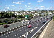 The motorway features eight traffic lanes with a 110 km/h speed limit
between the M6 Logan Motorway
and Smith Street Motorway
and generally six or four lanes at 100 km/h on other sections. The motorway passes through the major tourist region of the Gold Coast
, the destination for most of the vehicular traffic from Brisbane. More than A$2 billion has been spent on the motorway since 1990 to 1998, including widening the road and improving safety.
In March 2006 the Queensland
Government released planning for substantial changes to the section between Springwood
and Daisy Hill
. The changes are mainly to the entrances and exits in the section, most of which cause substantial traffic problems on surrounding streets and traffic backups onto the Motorway. The planned upgrade has led some people to protest, mainly by those whose homes will be resumed for the project. The Government hopes to commence development in early 2007 but it is reliant on the Federal Government funding half the cost. Planning for the Daisy Hill to Loganholme
section will begin August 2007, with the draft plans released for public consultation in April 2007 http://www.mainroads.qld.gov.au/MRWEB/Prod/Content.nsf/b495dab138a6b17a4a256a42001c8f4f/47ff8071e295f2864a2571ab000578a4?OpenDocument.
There are also plans to progressively widen the four lane section from Nerang
to Tugun
to six lanes. REF (review of environmental factors) and planning works is currently being undertaken, however, it is expected that sometime in 2010 any major widening works will commence. http://www.mainroads.qld.gov.au/MRWEB/Prod/Content.nsf/b495dab138a6b17a4a256a42001c8f4f/47ff8071e295f2864a2571ab000578a4?OpenDocument.
The Tugun Bypass
was completed in 2008 and has four lanes (two in each direction in 2008 and provision for six lane widening in the future) In 2025, widening will take place within the plans of provision from four lanes to six lanes "RTA and Tweed Council traffic master plan".
Travellers along the Motorway will pass close by many Gold Coast attractions such as Warner Bros. Movie World
, Wet 'n' Wild, and Dreamworld
, which are among the most popular theme parks in Australia.
servicing northbound. The travel centres include BP
and McDonalds as well as a couple of other fast food restaurants, picnic areas and a shop. Solar panels on the roofs of the centres provide power to the facilities.
Notes
Exits are numbered depending on distance to Brisbane
CBD.
Australia
Australia , officially the Commonwealth of Australia, is a country in the Southern Hemisphere comprising the mainland of the Australian continent, the island of Tasmania, and numerous smaller islands in the Indian and Pacific Oceans. It is the world's sixth-largest country by total area...
between Brisbane
Brisbane
Brisbane is the capital and most populous city in the Australian state of Queensland and the third most populous city in Australia. Brisbane's metropolitan area has a population of over 2 million, and the South East Queensland urban conurbation, centred around Brisbane, encompasses a population of...
, Queensland
Queensland
Queensland is a state of Australia, occupying the north-eastern section of the mainland continent. It is bordered by the Northern Territory, South Australia and New South Wales to the west, south-west and south respectively. To the east, Queensland is bordered by the Coral Sea and Pacific Ocean...
, and the New South Wales
New South Wales
New South Wales is a state of :Australia, located in the east of the country. It is bordered by Queensland, Victoria and South Australia to the north, south and west respectively. To the east, the state is bordered by the Tasman Sea, which forms part of the Pacific Ocean. New South Wales...
-Queensland border at Tweed Heads
Tweed Heads, New South Wales
Tweed Heads is a town located on the Tweed River in north-eastern New South Wales, Australia in Tweed Shire. Tweed Heads is located next to the border with Queensland, adjacent to the "Twin Town" of Coolangatta, a suburb of the Gold Coast...
. The motorway starts at Coronation Drive
Coronation Drive, Brisbane
Coronation Drive , popularly known as Coro Drive, is a road in Brisbane, Queensland which connects the Central Business District to the suburb of Toowong...
at Milton
Milton, Queensland
Milton is an inner suburb of Brisbane, Australia, located approximately west of Brisbane's central business district. The suburb is a mixture of light industry, warehouses, commercial offices, retail and single and multiple occupancy residences...
in Brisbane, and from 2008 links the Tweed Heads bypass in New South Wales. The Brisbane city section of the motorway is also often referred to by its former name, the Riverside Expressway. The first section opened in Brisbane in 1973 was originally known as the South East Freeway. The South East Freeway was known originally as the F3, however this has since been replaced in 1994.
Speed limit
Road speed limits are used in most countries to regulate the speed of road vehicles. Speed limits may define maximum , minimum or no speed limit and are normally indicated using a traffic sign...
between the M6 Logan Motorway
Logan Motorway
The M2/MR6 Logan Motorway offers motorists a quick link between Ipswich and the M1 or Pacific Motorway at Loganholme, and the Gateway Motorway, providing access to the Gold Coast on the eastern seaboard and to the rural areas of the Darling Downs to the west....
and Smith Street Motorway
Smith Street Motorway, Gold Coast
Smith Street Motorway is a main route in the Gold Coast, Australia. It is Gold Coast's second motorway, the other being Pacific Motorway. It connects one of the Gold Coast's major centres, Southport to the Pacific Motorway.The road is motorway standard for 5km from the Pacific Motorway , until...
and generally six or four lanes at 100 km/h on other sections. The motorway passes through the major tourist region of the Gold Coast
Gold Coast, Queensland
Gold Coast is a coastal city of Australia located in South East Queensland, 94km south of the state capital Brisbane. With a population approximately 540,000 in 2010, it is the second most populous city in the state, the sixth most populous city in the country, and also the most populous...
, the destination for most of the vehicular traffic from Brisbane. More than A$2 billion has been spent on the motorway since 1990 to 1998, including widening the road and improving safety.
In March 2006 the Queensland
Queensland
Queensland is a state of Australia, occupying the north-eastern section of the mainland continent. It is bordered by the Northern Territory, South Australia and New South Wales to the west, south-west and south respectively. To the east, Queensland is bordered by the Coral Sea and Pacific Ocean...
Government released planning for substantial changes to the section between Springwood
Springwood, Queensland
Springwood is a suburb of Logan City, Queensland, Australia. The size of Springwood is approximately 6 km². It has 17 parks covering nearly 9% of the total area. The population of Springwood in 1996 was 9,738 people. By 2001 the population was 9,084 showing a population decline of 7% in the...
and Daisy Hill
Daisy Hill, Queensland
Daisy Hill is a suburb of Logan City, Queensland, Australia. It lies between the Pacific Motorway and the Daisy Hill Conservation Park.-History:...
. The changes are mainly to the entrances and exits in the section, most of which cause substantial traffic problems on surrounding streets and traffic backups onto the Motorway. The planned upgrade has led some people to protest, mainly by those whose homes will be resumed for the project. The Government hopes to commence development in early 2007 but it is reliant on the Federal Government funding half the cost. Planning for the Daisy Hill to Loganholme
Loganholme, Queensland
Loganholme is a suburb of Logan City, Queensland, Australia. A major landmark in the area is the Logan Hyperdome shopping centre. A bus interchange is located adjacent to the Logan Hyperdome. The area is also home to the Loganholme State School....
section will begin August 2007, with the draft plans released for public consultation in April 2007 http://www.mainroads.qld.gov.au/MRWEB/Prod/Content.nsf/b495dab138a6b17a4a256a42001c8f4f/47ff8071e295f2864a2571ab000578a4?OpenDocument.
There are also plans to progressively widen the four lane section from Nerang
Nerang, Queensland
Nerang is a suburb on the Gold Coast in Queensland, Australia, that lies upon the Nerang River. At the 2006 Census, Nerang had a population of 16,066....
to Tugun
Tugun, Queensland
Tugun is a beachside suburb on the Gold Coast in Queensland, Australia. At the 2006 Census, Tugun had a population of 4,821.Its name is believed to have derived from an Indigenous word of unknown dialect meaning "breaking waves"....
to six lanes. REF (review of environmental factors) and planning works is currently being undertaken, however, it is expected that sometime in 2010 any major widening works will commence. http://www.mainroads.qld.gov.au/MRWEB/Prod/Content.nsf/b495dab138a6b17a4a256a42001c8f4f/47ff8071e295f2864a2571ab000578a4?OpenDocument.
The Tugun Bypass
Tugun Bypass
The Tugun Bypass is 7.5 km long, bypassing through the suburb of Tugun on the Gold Coast, Australia. The speed limit on the Tugun bypass is 100 km/h and provides a high-speed motorway link between the Gold Coast and northern New South Wales, separating interstate vehicles from local...
was completed in 2008 and has four lanes (two in each direction in 2008 and provision for six lane widening in the future) In 2025, widening will take place within the plans of provision from four lanes to six lanes "RTA and Tweed Council traffic master plan".
Travellers along the Motorway will pass close by many Gold Coast attractions such as Warner Bros. Movie World
Warner Bros. Movie World
Warner Bros. Movie World is a popular movie related theme park on the Gold Coast in Australia. It is owned and operated by Village Roadshow since the take over from Time Warner and is the only movie related park in Australia...
, Wet 'n' Wild, and Dreamworld
Dreamworld
Dreamworld is a large theme park situated on the Gold Coast in Queensland. It is currently Australia's largest theme park with over 27 rides including 4 roller coasters. The park is made up of several themed lands: Ocean Parade, Kid's World, Wiggles World, Gold Rush Country, Rocky Hollow, Tiger...
, which are among the most popular theme parks in Australia.
Travel Centres
The Pacific Motorway when it was upgraded in September 2000 was the first motorway in Queensland to have service centres integrated. Two centres, referred to as travel centres (although signed as Service Centres on the motorway signage) exist, on at Stapylton servicing southbound traffic, and CoomeraCoomera, Queensland
Coomera is a suburb on the Gold Coast in Queensland, Australia. At the 2006 Census, Coomera had a population of 1,420. The name Coomera comes from the Aboriginal word for fern....
servicing northbound. The travel centres include BP
BP
BP p.l.c. is a global oil and gas company headquartered in London, United Kingdom. It is the third-largest energy company and fourth-largest company in the world measured by revenues and one of the six oil and gas "supermajors"...
and McDonalds as well as a couple of other fast food restaurants, picnic areas and a shop. Solar panels on the roofs of the centres provide power to the facilities.
Speed Cameras
There is a fixed speed camera on the Pacific Motorway at Tarragindi, facing northbound. There is another at Loganholme just after the Logan Motorway exit facing northbound. Mobile speed cameras are frequently found pulled over on the left side, generally semi-obscured by bushes.Exits
Pacific Motorway  |
||
| Northbound exits | Exit Number | Southbound exits |
| End Motorway Road continues as Coronation Drive Coronation Drive, Brisbane Coronation Drive , popularly known as Coro Drive, is a road in Brisbane, Queensland which connects the Central Business District to the suburb of Toowong... to Indooroopilly Indooroopilly, Queensland Indooroopilly is a suburb of Brisbane, Australia which is located 7 km west of the Brisbane central business district.- Name derivation and history :... |
- | Northern Suburbs, Sunshine Coast Sunshine Coast, Queensland The Sunshine Coast is an urban area in South East Queensland, north of the state capital of Brisbane on the Pacific Ocean coastline. Although it does not have a central business district, by population it ranks as the 10th largest metropolis in Australia and the third largest in... Hale Street / Inner City Bypass Inner City Bypass M3 Inner City Bypass is a major motorway standard road in Brisbane, Australia. The 4.5km bypass is north of the city. Bypassing the Brisbane central business district, it connects Brisbane’s Pacific Motorway and Go Between Bridge at Hale Street to Kingsford Smith Drive, the Clem Jones Tunnel and... (ICB)  |
| Northern Suburbs, Sunshine Coast Sunshine Coast, Queensland The Sunshine Coast is an urban area in South East Queensland, north of the state capital of Brisbane on the Pacific Ocean coastline. Although it does not have a central business district, by population it ranks as the 10th largest metropolis in Australia and the third largest in... Hale Street / Inner City Bypass Inner City Bypass M3 Inner City Bypass is a major motorway standard road in Brisbane, Australia. The 4.5km bypass is north of the city. Bypassing the Brisbane central business district, it connects Brisbane’s Pacific Motorway and Go Between Bridge at Hale Street to Kingsford Smith Drive, the Clem Jones Tunnel and... (ICB) |
||
| no exit | - | Skew Street |
| Herschel Street | - | Southbound traffic use North Quay |
| Turbot Street | - | Start Motorway |
| Elizabeth Street | - | Elizabeth Street |
| Margaret Street | - | Margaret Street |
| South Brisbane South Brisbane, Queensland South Brisbane is an inner city suburb of Brisbane, Australia located on the southern bank of the Brisbane River, directly connected to the central business district by the Kurilpa, Victoria and Goodwill bridges.... Stanley Street Stanley Street, Brisbane Stanley Street is a major street in Brisbane, Queensland. It caries the designation state route 41 for the entirety of its length and state route 10 between the Vulture Street and Annerley Road intersections. For the majority of its length the road is a one-way carriageway. The route is a major... |
2 | South Brisbane South Brisbane, Queensland South Brisbane is an inner city suburb of Brisbane, Australia located on the southern bank of the Brisbane River, directly connected to the central business district by the Kurilpa, Victoria and Goodwill bridges.... Vulture Street |
| Northern Suburbs, Sunshine Coast Sunshine Coast, Queensland The Sunshine Coast is an urban area in South East Queensland, north of the state capital of Brisbane on the Pacific Ocean coastline. Although it does not have a central business district, by population it ranks as the 10th largest metropolis in Australia and the third largest in... Clem Jones Tunnel  |
4 | no exit |
| Greenslopes Greenslopes, Queensland Greenslopes is a moderately sized suburb of the city of Brisbane, state capital of Queensland, Australia."Greenslopes" is also the name of a Queensland state electorate. The electorate contains only a small fraction of the suburb of the same name... Juliette Street |
5 | Greenslopes Greenslopes, Queensland Greenslopes is a moderately sized suburb of the city of Brisbane, state capital of Queensland, Australia."Greenslopes" is also the name of a Queensland state electorate. The electorate contains only a small fraction of the suburb of the same name... Cornwall Street |
| no exit | 8 | Tarragindi Tarragindi, Queensland Tarragindi is a suburb on the southern side of Brisbane, Queensland, Australia. It is represented through the Holland Park and Moorooka Ward councillors on the Brisbane City Council.-Origin of the name:... Marshall Road |
| Mount Gravatt Mount Gravatt, Queensland Mount Gravatt is the name of both a major suburb of Brisbane, Queensland, Australia and a prominent hill in this suburb. The suburb is situated in the south-east of the city and was one of Brisbane's largest... Gaza Road |
9 | no exit |
| no exit | 11 | Upper Mount Gravatt Upper Mount Gravatt, Queensland Upper Mount Gravatt is a suburb in Brisbane, to the south of Mount Gravatt. It has increasingly become an important centre in the last 15 years... Klump Road / Mains Road |
| Eight Mile Plains Eight Mile Plains, Queensland Eight Mile Plains is a southern suburb of Brisbane, Queensland, Australia. It is located some 13 kilometres from the Brisbane central business district.... , Upper Mount Gravatt Upper Mount Gravatt, Queensland Upper Mount Gravatt is a suburb in Brisbane, to the south of Mount Gravatt. It has increasingly become an important centre in the last 15 years... Logan Road |
14 | Eight Mile Plains Eight Mile Plains, Queensland Eight Mile Plains is a southern suburb of Brisbane, Queensland, Australia. It is located some 13 kilometres from the Brisbane central business district.... , Upper Mount Gravatt Upper Mount Gravatt, Queensland Upper Mount Gravatt is a suburb in Brisbane, to the south of Mount Gravatt. It has increasingly become an important centre in the last 15 years... Logan Road |
| End Start |
16 | no exit |
| Sunshine Coast Sunshine Coast, Queensland The Sunshine Coast is an urban area in South East Queensland, north of the state capital of Brisbane on the Pacific Ocean coastline. Although it does not have a central business district, by population it ranks as the 10th largest metropolis in Australia and the third largest in... , Brisbane Airport Brisbane Airport Brisbane Airport is the sole passenger airport serving Brisbane and the third busiest in Australia, after Melbourne and Sydney Airports. Brisbane Airport has won many awards. Located in the suburb with the same name, the airport serves the city of Brisbane and the surrounding metropolitan area... Gateway Motorway Gateway Motorway The Gateway Motorway is a major motorway in Brisbane, Queensland, Australia. The Gateway Bridge is owned and operated by Queensland Motorways.... |
End Start |
|
| no exit | 19 | Rochedale South Rochedale South, Queensland Rochedale South is a suburb of Logan City, Queensland, Australia.-Geography:Rochedale is known for its rich, red soil that is good for crops. Yet due to recent years of drought in the area, much of the farming has been abandoned and are now commercialised.... , Springwood Springwood, Queensland Springwood is a suburb of Logan City, Queensland, Australia. The size of Springwood is approximately 6 km². It has 17 parks covering nearly 9% of the total area. The population of Springwood in 1996 was 9,738 people. By 2001 the population was 9,084 showing a population decline of 7% in the... , Underwood Underwood, Queensland Underwood is a suburb located south-east of the Brisbane central business district in Queensland, Australia. Its Local Government Area is the Logan City Council.The origin of the suburb name is from William Underwood who was an early property owner in the area... Rochedale Road |
| Springwood Springwood, Queensland Springwood is a suburb of Logan City, Queensland, Australia. The size of Springwood is approximately 6 km². It has 17 parks covering nearly 9% of the total area. The population of Springwood in 1996 was 9,738 people. By 2001 the population was 9,084 showing a population decline of 7% in the... , Underwood Underwood, Queensland Underwood is a suburb located south-east of the Brisbane central business district in Queensland, Australia. Its Local Government Area is the Logan City Council.The origin of the suburb name is from William Underwood who was an early property owner in the area... Logan Road |
20 | Springwood Springwood, Queensland Springwood is a suburb of Logan City, Queensland, Australia. The size of Springwood is approximately 6 km². It has 17 parks covering nearly 9% of the total area. The population of Springwood in 1996 was 9,738 people. By 2001 the population was 9,084 showing a population decline of 7% in the... Old Pacific Highway |
| no exit | 22 | Springwood Springwood, Queensland Springwood is a suburb of Logan City, Queensland, Australia. The size of Springwood is approximately 6 km². It has 17 parks covering nearly 9% of the total area. The population of Springwood in 1996 was 9,738 people. By 2001 the population was 9,084 showing a population decline of 7% in the... Old Pacific Highway |
| Daisy Hill Daisy Hill, Queensland Daisy Hill is a suburb of Logan City, Queensland, Australia. It lies between the Pacific Motorway and the Daisy Hill Conservation Park.-History:... , Logan Central Logan Central, Queensland Logan Central is a suburb of Logan City, Queensland, Australia.Once forming part of Woodridge, Logan Central is the official central business district of Logan City and is a major activity centre, with many shops and local businesses operating in the area, mostly along the Wembley Road corridor... Paradise Road |
23 | Slacks Creek, Logan Central Logan Central, Queensland Logan Central is a suburb of Logan City, Queensland, Australia.Once forming part of Woodridge, Logan Central is the official central business district of Logan City and is a major activity centre, with many shops and local businesses operating in the area, mostly along the Wembley Road corridor... Chatswood Road |
| Daisy Hill Daisy Hill, Queensland Daisy Hill is a suburb of Logan City, Queensland, Australia. It lies between the Pacific Motorway and the Daisy Hill Conservation Park.-History:... , Loganlea Loganlea, Queensland Loganlea is a suburb of Logan City, Queensland, Australia.-Transport:Loganlea railway station provides access to regular Citytrain services to Brisbane, Beenleigh and Gold Coast.-External links:* *... Winnets Road |
24 | Daisy Hill Daisy Hill, Queensland Daisy Hill is a suburb of Logan City, Queensland, Australia. It lies between the Pacific Motorway and the Daisy Hill Conservation Park.-History:... , Loganlea Loganlea, Queensland Loganlea is a suburb of Logan City, Queensland, Australia.-Transport:Loganlea railway station provides access to regular Citytrain services to Brisbane, Beenleigh and Gold Coast.-External links:* *... Loganlea Road |
| Slacks Creek Nujooloo Road |
25 | Shailer Park Shailer Park, Queensland Shailer Park is a suburb of Logan City, Queensland, Australia.It is a suburb of mainly middle class residential areas, and sits on hilly terrain between the Pacific Motorway and extensive forest and bushland to the north... Shailer Road |
| Shailer Park Shailer Park, Queensland Shailer Park is a suburb of Logan City, Queensland, Australia.It is a suburb of mainly middle class residential areas, and sits on hilly terrain between the Pacific Motorway and extensive forest and bushland to the north... Old Pacific Highway |
26 | no exit |
| Shailer Park Shailer Park, Queensland Shailer Park is a suburb of Logan City, Queensland, Australia.It is a suburb of mainly middle class residential areas, and sits on hilly terrain between the Pacific Motorway and extensive forest and bushland to the north... , Loganholme Loganholme, Queensland Loganholme is a suburb of Logan City, Queensland, Australia. A major landmark in the area is the Logan Hyperdome shopping centre. A bus interchange is located adjacent to the Logan Hyperdome. The area is also home to the Loganholme State School.... Bryants Road |
28 | Shailer Park Shailer Park, Queensland Shailer Park is a suburb of Logan City, Queensland, Australia.It is a suburb of mainly middle class residential areas, and sits on hilly terrain between the Pacific Motorway and extensive forest and bushland to the north... , Tanah Merah Tanah Merah, Queensland Tanah Merah is a suburb of Logan City, Queensland, Australia.Tanah Merah means 'red earth' in Indonesian/Malay. This type of soil is found across the local area.The land was once owned by the Murray family who sold it off in sections to developers... Bryants Road |
| Loganholme Loganholme, Queensland Loganholme is a suburb of Logan City, Queensland, Australia. A major landmark in the area is the Logan Hyperdome shopping centre. A bus interchange is located adjacent to the Logan Hyperdome. The area is also home to the Loganholme State School.... , Redland Bay Redland Bay, Queensland Redland Bay is a suburb south-east of Brisbane, the capital of Queensland, Australia, and is part of the Redland City local government area. It is named for the bay it sits on, which forms part of larger Moreton Bay... , Cleveland Cleveland, Queensland Cleveland is a suburb located approximately east-south-east of Brisbane, the capital of the Australian state of Queensland, and is the council seat for the Redland City local government area... Beenleigh — Redland Bay Road |
30 | Loganholme Loganholme, Queensland Loganholme is a suburb of Logan City, Queensland, Australia. A major landmark in the area is the Logan Hyperdome shopping centre. A bus interchange is located adjacent to the Logan Hyperdome. The area is also home to the Loganholme State School.... , Redland Bay Redland Bay, Queensland Redland Bay is a suburb south-east of Brisbane, the capital of Queensland, Australia, and is part of the Redland City local government area. It is named for the bay it sits on, which forms part of larger Moreton Bay... , Cleveland Cleveland, Queensland Cleveland is a suburb located approximately east-south-east of Brisbane, the capital of the Australian state of Queensland, and is the council seat for the Redland City local government area... Beenleigh — Redland Bay Road |
| Browns Plains, Ipswich Ipswich, Queensland Ipswich is a city in South-East Queensland, Australia. Situated along the Bremer River Valley approximately 40 kilometres away from the state's capital Brisbane. The suburb by the same name forms the city's Central Business District and administrative centre... , Toowoomba Toowoomba, Queensland Toowoomba is a city in Southern Queensland, Australia. It is located west of Queensland's capital city, Brisbane. With an estimated district population of 128,600, Toowoomba is Australia's second largest inland city and its largest non-capital inland city... Logan Motorway Logan Motorway The M2/MR6 Logan Motorway offers motorists a quick link between Ipswich and the M1 or Pacific Motorway at Loganholme, and the Gateway Motorway, providing access to the Gold Coast on the eastern seaboard and to the rural areas of the Darling Downs to the west....  |
31 | Browns Plains, Ipswich Ipswich, Queensland Ipswich is a city in South-East Queensland, Australia. Situated along the Bremer River Valley approximately 40 kilometres away from the state's capital Brisbane. The suburb by the same name forms the city's Central Business District and administrative centre... , Toowoomba Toowoomba, Queensland Toowoomba is a city in Southern Queensland, Australia. It is located west of Queensland's capital city, Brisbane. With an estimated district population of 128,600, Toowoomba is Australia's second largest inland city and its largest non-capital inland city... Logan Motorway Logan Motorway The M2/MR6 Logan Motorway offers motorists a quick link between Ipswich and the M1 or Pacific Motorway at Loganholme, and the Gateway Motorway, providing access to the Gold Coast on the eastern seaboard and to the rural areas of the Darling Downs to the west.... |
| Beenleigh Beenleigh, Queensland Beenleigh is a suburb in the Logan City area of Queensland, Australia. Beenleigh and adjoining suburbs are located near the confluence of the Logan and Albert rivers... City Road |
34 | Beenleigh Beenleigh, Queensland Beenleigh is a suburb in the Logan City area of Queensland, Australia. Beenleigh and adjoining suburbs are located near the confluence of the Logan and Albert rivers... , Eagleby Eagleby, Queensland Eagleby is a suburb of Logan City in Queensland, Australia located on the southern bank of the Logan River at the juncture with the Albert which forms the southern and eastern boundary. Eagleby is northeast of Beenleigh, and was originally a suburb of Beenleigh.... City Road |
| Beenleigh Beenleigh, Queensland Beenleigh is a suburb in the Logan City area of Queensland, Australia. Beenleigh and adjoining suburbs are located near the confluence of the Logan and Albert rivers... , Eagleby Eagleby, Queensland Eagleby is a suburb of Logan City in Queensland, Australia located on the southern bank of the Logan River at the juncture with the Albert which forms the southern and eastern boundary. Eagleby is northeast of Beenleigh, and was originally a suburb of Beenleigh.... Main Street |
35 | Beenleigh Beenleigh, Queensland Beenleigh is a suburb in the Logan City area of Queensland, Australia. Beenleigh and adjoining suburbs are located near the confluence of the Logan and Albert rivers... , Eagleby Eagleby, Queensland Eagleby is a suburb of Logan City in Queensland, Australia located on the southern bank of the Logan River at the juncture with the Albert which forms the southern and eastern boundary. Eagleby is northeast of Beenleigh, and was originally a suburb of Beenleigh.... Main Street |
| Yatala Yatala, Queensland Yatala is a suburb in the outer northern areas of Gold Coast City in Queensland, Australia.Surrounding suburbs of Yatala include Beenleigh, Windaroo, and Stapylton... , Jacobs Well Stapylton — Jacobs Well Road |
38 | Stapylton, Jacobs Well, Stapylton Travel Centre Stapylton — Jacobs Well Road |
| Yatala Yatala, Queensland Yatala is a suburb in the outer northern areas of Gold Coast City in Queensland, Australia.Surrounding suburbs of Yatala include Beenleigh, Windaroo, and Stapylton... , Ormeau Ormeau, Queensland Ormeau is a hinterland town on the Gold Coast in Queensland, Australia. Ormeau was originally a French name which means ‘young elm’. It came from Ormeau House the estate of Major A. J. Boyd, a sugar planter of the 1860s. For all you need to know about Ormeau please visit http://www.myormeau.com.au... Computer Road |
41 | Yatala Yatala, Queensland Yatala is a suburb in the outer northern areas of Gold Coast City in Queensland, Australia.Surrounding suburbs of Yatala include Beenleigh, Windaroo, and Stapylton... , Ormeau Ormeau, Queensland Ormeau is a hinterland town on the Gold Coast in Queensland, Australia. Ormeau was originally a French name which means ‘young elm’. It came from Ormeau House the estate of Major A. J. Boyd, a sugar planter of the 1860s. For all you need to know about Ormeau please visit http://www.myormeau.com.au... Computer Road |
| Ormeau Ormeau, Queensland Ormeau is a hinterland town on the Gold Coast in Queensland, Australia. Ormeau was originally a French name which means ‘young elm’. It came from Ormeau House the estate of Major A. J. Boyd, a sugar planter of the 1860s. For all you need to know about Ormeau please visit http://www.myormeau.com.au... , Kingsholme, Norwell Mirambeena Drive |
45 | Ormeau Ormeau, Queensland Ormeau is a hinterland town on the Gold Coast in Queensland, Australia. Ormeau was originally a French name which means ‘young elm’. It came from Ormeau House the estate of Major A. J. Boyd, a sugar planter of the 1860s. For all you need to know about Ormeau please visit http://www.myormeau.com.au... , Kingsholme, Pimpama Pimpama, Queensland Pimpama is a suburb in the northern Gold Coast. It is located on the Pacific Motorway 30 km north of Surfers Paradise. The township of Pimpama is presently the last remaining rural town on the Pacific Motorway between Brisbane and the Gold Coast... Peachey Road |
| Pimpama Pimpama, Queensland Pimpama is a suburb in the northern Gold Coast. It is located on the Pacific Motorway 30 km north of Surfers Paradise. The township of Pimpama is presently the last remaining rural town on the Pacific Motorway between Brisbane and the Gold Coast... , Willow Vale, Jacobs Well Pimpama — Jacobs Well Road |
49 | Pimpama Pimpama, Queensland Pimpama is a suburb in the northern Gold Coast. It is located on the Pacific Motorway 30 km north of Surfers Paradise. The township of Pimpama is presently the last remaining rural town on the Pacific Motorway between Brisbane and the Gold Coast... , Willow Vale, Jacobs Well Pimpama — Jacobs Well Road |
| Coomera Coomera, Queensland Coomera is a suburb on the Gold Coast in Queensland, Australia. At the 2006 Census, Coomera had a population of 1,420. The name Coomera comes from the Aboriginal word for fern.... , Upper Coomera Upper Coomera, Queensland Upper Coomera is a suburb on the Gold Coast in Queensland, Australia. Coomera has long been earmarked by the Gold Coast City Council and the State Government for a new satellite growth suburb of the Gold Coast, similar in many ways to Robina.... , Coomera Travel Centre, Dreamworld Dreamworld Dreamworld is a large theme park situated on the Gold Coast in Queensland. It is currently Australia's largest theme park with over 27 rides including 4 roller coasters. The park is made up of several themed lands: Ocean Parade, Kid's World, Wiggles World, Gold Rush Country, Rocky Hollow, Tiger... Foxwell Road |
54 | Coomera Coomera, Queensland Coomera is a suburb on the Gold Coast in Queensland, Australia. At the 2006 Census, Coomera had a population of 1,420. The name Coomera comes from the Aboriginal word for fern.... , Upper Coomera Upper Coomera, Queensland Upper Coomera is a suburb on the Gold Coast in Queensland, Australia. Coomera has long been earmarked by the Gold Coast City Council and the State Government for a new satellite growth suburb of the Gold Coast, similar in many ways to Robina.... , Dreamworld Dreamworld Dreamworld is a large theme park situated on the Gold Coast in Queensland. It is currently Australia's largest theme park with over 27 rides including 4 roller coasters. The park is made up of several themed lands: Ocean Parade, Kid's World, Wiggles World, Gold Rush Country, Rocky Hollow, Tiger... Foxwell Road |
| Oxenford Oxenford, Queensland Oxenford is a suburb on the Gold Coast in Queensland, Australia. At the 2006 Census, Oxenford had a population of 9,007.The suburb is bordered to the north by the Coomera River; the Pacific Motorway forms the eastern boundary. The western edge of the suburb is also bordered by the Coomera River,... , Hope Island Hope Island, Queensland Hope Island is a suburb on the Gold Coast in Queensland, Australia. At the 2006 Census, Hope Island had a population of 5,396. Hope Island is popular due to its close proximity to both the Gold Coast beaches and Brisbane city.... , Tamborine Mountain Hope Island Road, Tamborine — Oxenford Road |
57 | Oxenford Oxenford, Queensland Oxenford is a suburb on the Gold Coast in Queensland, Australia. At the 2006 Census, Oxenford had a population of 9,007.The suburb is bordered to the north by the Coomera River; the Pacific Motorway forms the eastern boundary. The western edge of the suburb is also bordered by the Coomera River,... , Hope Island Hope Island, Queensland Hope Island is a suburb on the Gold Coast in Queensland, Australia. At the 2006 Census, Hope Island had a population of 5,396. Hope Island is popular due to its close proximity to both the Gold Coast beaches and Brisbane city.... , Tamborine Mountain Hope Island Road, Tamborine — Oxenford Road |
| Helensvale Helensvale, Queensland Helensvale is a suburb on the Gold Coast in Queensland , Australia and was named after Helena White.At the 2006 Census, Helensvale had a population of 14,767.... , Oxenford Oxenford, Queensland Oxenford is a suburb on the Gold Coast in Queensland, Australia. At the 2006 Census, Oxenford had a population of 9,007.The suburb is bordered to the north by the Coomera River; the Pacific Motorway forms the eastern boundary. The western edge of the suburb is also bordered by the Coomera River,... , MovieWorld, Wet'n'Wild Wet'n'Wild Water World Wet'n'Wild Water World is a large water park situated in Oxenford, Gold Coast, owned by Warner Village Theme Parks. In 2009, the park received 1,095,000 visitors ranking it first in Australia and eighth in the world. Wet'n'Wild Water World is located adjacent to Warner Bros. Movie World, a... Helensvale Road |
60 | Helensvale Helensvale, Queensland Helensvale is a suburb on the Gold Coast in Queensland , Australia and was named after Helena White.At the 2006 Census, Helensvale had a population of 14,767.... , Oxenford Oxenford, Queensland Oxenford is a suburb on the Gold Coast in Queensland, Australia. At the 2006 Census, Oxenford had a population of 9,007.The suburb is bordered to the north by the Coomera River; the Pacific Motorway forms the eastern boundary. The western edge of the suburb is also bordered by the Coomera River,... , MovieWorld, Wet'n'Wild Wet'n'Wild Water World Wet'n'Wild Water World is a large water park situated in Oxenford, Gold Coast, owned by Warner Village Theme Parks. In 2009, the park received 1,095,000 visitors ranking it first in Australia and eighth in the world. Wet'n'Wild Water World is located adjacent to Warner Bros. Movie World, a... Helensvale Road |
| Helensvale Helensvale, Queensland Helensvale is a suburb on the Gold Coast in Queensland , Australia and was named after Helena White.At the 2006 Census, Helensvale had a population of 14,767.... , Pacific Pines Pacific Pines, Queensland Pacific Pines is a is a suburb on the Gold Coast in Queensland, Australia. It is located between the Pacific Motorway and the NNE side of the Nerang State Forest. At the 2006 Census, Pacific Pines had a population of 5,967... Gold Coast Highway Gold Coast Highway The Gold Coast Highway in Queensland, Australia links the coastal suburbs of the Gold Coast. 33 km in length, the highway passes through popular tourist resorts such as Southport, Surfers Paradise, Burleigh Heads and Currumbin... |
62 | Helensvale Helensvale, Queensland Helensvale is a suburb on the Gold Coast in Queensland , Australia and was named after Helena White.At the 2006 Census, Helensvale had a population of 14,767.... , Pacific Pines Pacific Pines, Queensland Pacific Pines is a is a suburb on the Gold Coast in Queensland, Australia. It is located between the Pacific Motorway and the NNE side of the Nerang State Forest. At the 2006 Census, Pacific Pines had a population of 5,967... Gold Coast Highway Gold Coast Highway The Gold Coast Highway in Queensland, Australia links the coastal suburbs of the Gold Coast. 33 km in length, the highway passes through popular tourist resorts such as Southport, Surfers Paradise, Burleigh Heads and Currumbin... |
| Southport Southport, Queensland -Sport:The Southport Sharks Australian rules football club has a presence in the area, including a club and function centre.-Transport:The Broadwaterway is a foreshoreway that encourages pedestrians and cyclists to travel along the Broadwater foreshores of Southport.A ferry terminal is planned for... , Pacific Pines Pacific Pines, Queensland Pacific Pines is a is a suburb on the Gold Coast in Queensland, Australia. It is located between the Pacific Motorway and the NNE side of the Nerang State Forest. At the 2006 Census, Pacific Pines had a population of 5,967... Sea World Sea World Sea World is a marine mammal park, oceanarium, and theme park located on the Gold Coast, Queensland, Australia. It includes rides, animal exhibits and other attractions, and promotes conservation through education and through the rescue and rehabilitation of sick, injured or orphaned wildlife. The... Smith Street Motorway |
66 | Southport Southport, Queensland -Sport:The Southport Sharks Australian rules football club has a presence in the area, including a club and function centre.-Transport:The Broadwaterway is a foreshoreway that encourages pedestrians and cyclists to travel along the Broadwater foreshores of Southport.A ferry terminal is planned for... , Pacific Pines Pacific Pines, Queensland Pacific Pines is a is a suburb on the Gold Coast in Queensland, Australia. It is located between the Pacific Motorway and the NNE side of the Nerang State Forest. At the 2006 Census, Pacific Pines had a population of 5,967... Sea World Sea World Sea World is a marine mammal park, oceanarium, and theme park located on the Gold Coast, Queensland, Australia. It includes rides, animal exhibits and other attractions, and promotes conservation through education and through the rescue and rehabilitation of sick, injured or orphaned wildlife. The... Smith Street Motorway |
| Nerang Nerang, Queensland Nerang is a suburb on the Gold Coast in Queensland, Australia, that lies upon the Nerang River. At the 2006 Census, Nerang had a population of 16,066.... , Ashmore Ashmore, Queensland Ashmore is a suburb on the Gold Coast in Queensland, Australia. At the 2006 Census, Ashmore had a population of 11,514.The area's name derives from a locality or family property in England... , Southport Southport, Queensland -Sport:The Southport Sharks Australian rules football club has a presence in the area, including a club and function centre.-Transport:The Broadwaterway is a foreshoreway that encourages pedestrians and cyclists to travel along the Broadwater foreshores of Southport.A ferry terminal is planned for... Southport — Nerang Road |
69 | Nerang Nerang, Queensland Nerang is a suburb on the Gold Coast in Queensland, Australia, that lies upon the Nerang River. At the 2006 Census, Nerang had a population of 16,066.... , Ashmore Ashmore, Queensland Ashmore is a suburb on the Gold Coast in Queensland, Australia. At the 2006 Census, Ashmore had a population of 11,514.The area's name derives from a locality or family property in England... , Surfers Paradise Surfers Paradise, Queensland Surfers Paradise is a suburb on the Gold Coast in Queensland, Australia. At the 2006 Census, Surfers Paradise had a population of 18,501.... Southport — Nerang Road |
| Nerang Nerang, Queensland Nerang is a suburb on the Gold Coast in Queensland, Australia, that lies upon the Nerang River. At the 2006 Census, Nerang had a population of 16,066.... , Broadbeach Broadbeach, Queensland Broadbeach is a suburb on the Gold Coast, in Queensland, Australia. At the 2006 Census, Broadbeach had a population of 3,791.Development in the area today mostly incorporates low rise structures, consisting of single bedroom houses and apartment blocks... , Beaudesert Beaudesert, Queensland Beaudesert is a town located on the Mount Lindesay Highway, some 64 km south of Brisbane. It is possibly named after Beau Desert Park, the property of Charles Henry Alexander Paget, 6th Marquess of Anglesey in Staffordshire, England... , Murwillumbah Murwillumbah, New South Wales Murwillumbah is a town of approximately 7,500 people in far north-eastern New South Wales, Australia in the Tweed Shire. It lies on the Tweed River, 848 km north-east of Sydney, 13 km south of the Queensland border and 132 km south of Brisbane. At the 2006 census, Murwillumbah had a... Nerang — Broadbeach Road |
71 | Nerang Nerang, Queensland Nerang is a suburb on the Gold Coast in Queensland, Australia, that lies upon the Nerang River. At the 2006 Census, Nerang had a population of 16,066.... , Broadbeach Broadbeach, Queensland Broadbeach is a suburb on the Gold Coast, in Queensland, Australia. At the 2006 Census, Broadbeach had a population of 3,791.Development in the area today mostly incorporates low rise structures, consisting of single bedroom houses and apartment blocks... , Beaudesert Beaudesert, Queensland Beaudesert is a town located on the Mount Lindesay Highway, some 64 km south of Brisbane. It is possibly named after Beau Desert Park, the property of Charles Henry Alexander Paget, 6th Marquess of Anglesey in Staffordshire, England... , Murwillumbah Murwillumbah, New South Wales Murwillumbah is a town of approximately 7,500 people in far north-eastern New South Wales, Australia in the Tweed Shire. It lies on the Tweed River, 848 km north-east of Sydney, 13 km south of the Queensland border and 132 km south of Brisbane. At the 2006 census, Murwillumbah had a... Nerang — Broadbeach Road |
| no exit | 71A | Nerang Nerang, Queensland Nerang is a suburb on the Gold Coast in Queensland, Australia, that lies upon the Nerang River. At the 2006 Census, Nerang had a population of 16,066.... Pappas Way |
| Nerang Nerang, Queensland Nerang is a suburb on the Gold Coast in Queensland, Australia, that lies upon the Nerang River. At the 2006 Census, Nerang had a population of 16,066.... , Cararra Carrara, Queensland Carrara is a suburb on the Gold Coast in Queensland, Australia, located on the southern bank of the Nerang River. At the 2006 Census, Carrara had a population of 10,687.... , Broadbeach Broadbeach, Queensland Broadbeach is a suburb on the Gold Coast, in Queensland, Australia. At the 2006 Census, Broadbeach had a population of 3,791.Development in the area today mostly incorporates low rise structures, consisting of single bedroom houses and apartment blocks... Nielsons Road |
73 | Nerang Nerang, Queensland Nerang is a suburb on the Gold Coast in Queensland, Australia, that lies upon the Nerang River. At the 2006 Census, Nerang had a population of 16,066.... , Cararra Carrara, Queensland Carrara is a suburb on the Gold Coast in Queensland, Australia, located on the southern bank of the Nerang River. At the 2006 Census, Carrara had a population of 10,687.... , Broadbeach Broadbeach, Queensland Broadbeach is a suburb on the Gold Coast, in Queensland, Australia. At the 2006 Census, Broadbeach had a population of 3,791.Development in the area today mostly incorporates low rise structures, consisting of single bedroom houses and apartment blocks... Nielsons Road |
| Worongary, Cararra Carrara, Queensland Carrara is a suburb on the Gold Coast in Queensland, Australia, located on the southern bank of the Nerang River. At the 2006 Census, Carrara had a population of 10,687.... Elysium Road |
75 | Worongary, Cararra Carrara, Queensland Carrara is a suburb on the Gold Coast in Queensland, Australia, located on the southern bank of the Nerang River. At the 2006 Census, Carrara had a population of 10,687.... Elysium Road |
| Worongary, Merrimac Merrimac, Queensland Merrimac is a suburb on the Gold Coast in Queensland, Australia. At the 2006 Census, Merrimac had a population of 5,690. The community takes its name from two possible sources: the Merrimac River in New England or the USS Merrimac, a Union navy frigate itself named for the river.Merrimac is... , Broadbeach Broadbeach, Queensland Broadbeach is a suburb on the Gold Coast, in Queensland, Australia. At the 2006 Census, Broadbeach had a population of 3,791.Development in the area today mostly incorporates low rise structures, consisting of single bedroom houses and apartment blocks... , Tallai Gold Coast — Springbrook Road (Gooding Drive) |
77 | Worongary, Merrimac Merrimac, Queensland Merrimac is a suburb on the Gold Coast in Queensland, Australia. At the 2006 Census, Merrimac had a population of 5,690. The community takes its name from two possible sources: the Merrimac River in New England or the USS Merrimac, a Union navy frigate itself named for the river.Merrimac is... , Broadbeach Broadbeach, Queensland Broadbeach is a suburb on the Gold Coast, in Queensland, Australia. At the 2006 Census, Broadbeach had a population of 3,791.Development in the area today mostly incorporates low rise structures, consisting of single bedroom houses and apartment blocks... , Tallai Gold Coast — Springbrook Road (Gooding Drive) |
| Mudgeeraba Mudgeeraba, Queensland Mudgeeraba is a suburb of the Gold Coast. Mudgeeraba is remnant of the type of township that characterises the rural hinterland of the Gold Coast. Subdivision of land was conventional and buildings were traditionally rural or rural commercial. Mudgeeraba, like other areas, was an early centre,... , Robina Robina, Queensland Robina is a suburb on the Gold Coast in Queensland, Australia. At the 2006 Census, Robina had a population of 19,182.The Robina Town Centre shopping centre and Bond University are located in Robina.- History :... , Springbrook Springbrook National Park Springbrook National Park is a national park at Springbrook on the McPherson Range in the Gold Coast hinterland of Queensland, , 96 km south of Brisbane. It is part of the Shield Volcano Group of the World Heritage site Gondwana Rainforests of Australia... Robina Parkway |
79 | Mudgeeraba Mudgeeraba, Queensland Mudgeeraba is a suburb of the Gold Coast. Mudgeeraba is remnant of the type of township that characterises the rural hinterland of the Gold Coast. Subdivision of land was conventional and buildings were traditionally rural or rural commercial. Mudgeeraba, like other areas, was an early centre,... , Robina Robina, Queensland Robina is a suburb on the Gold Coast in Queensland, Australia. At the 2006 Census, Robina had a population of 19,182.The Robina Town Centre shopping centre and Bond University are located in Robina.- History :... Robina Parkway |
| Mudgeeraba Mudgeeraba, Queensland Mudgeeraba is a suburb of the Gold Coast. Mudgeeraba is remnant of the type of township that characterises the rural hinterland of the Gold Coast. Subdivision of land was conventional and buildings were traditionally rural or rural commercial. Mudgeeraba, like other areas, was an early centre,... , Springbrook Springbrook National Park Springbrook National Park is a national park at Springbrook on the McPherson Range in the Gold Coast hinterland of Queensland, , 96 km south of Brisbane. It is part of the Shield Volcano Group of the World Heritage site Gondwana Rainforests of Australia... The Link Way |
80 | no exit |
| Robina Robina, Queensland Robina is a suburb on the Gold Coast in Queensland, Australia. At the 2006 Census, Robina had a population of 19,182.The Robina Town Centre shopping centre and Bond University are located in Robina.- History :... , Mudgeeraba Mudgeeraba, Queensland Mudgeeraba is a suburb of the Gold Coast. Mudgeeraba is remnant of the type of township that characterises the rural hinterland of the Gold Coast. Subdivision of land was conventional and buildings were traditionally rural or rural commercial. Mudgeeraba, like other areas, was an early centre,... Somerset Drive |
82 | Robina Robina, Queensland Robina is a suburb on the Gold Coast in Queensland, Australia. At the 2006 Census, Robina had a population of 19,182.The Robina Town Centre shopping centre and Bond University are located in Robina.- History :... , Mudgeeraba Mudgeeraba, Queensland Mudgeeraba is a suburb of the Gold Coast. Mudgeeraba is remnant of the type of township that characterises the rural hinterland of the Gold Coast. Subdivision of land was conventional and buildings were traditionally rural or rural commercial. Mudgeeraba, like other areas, was an early centre,... Robina Parkway |
| Burleigh Heads Burleigh Heads, Queensland Burleigh Heads is a suburb on the Gold Coast in Queensland, Australia. At the 2006 Census, Burleigh Heads had a population of 7,606.Burleigh Heads is renowned for its surf break, and is an alternative to the more tourist ridden towns of the Gold Coast... , Reedy Creek Reedy Creek, Queensland Reedy Creek is a suburb of the Gold Coast in Queensland, Australia. The suburb is adjacent to the Pacific Motorway . Located in the hinterland towards the southern end of the city, Reedy Creek is a developing residential area. Three schools are located in the suburb: Hillcrest Christian College,... , Varsity Lakes Varsity Lakes, Queensland Varsity Lakes is a suburb of the Gold Coast, Queensland. This suburb was originally known as Stephens, however in 2002 Stephens, Andrews and a section of Robina was amalgamated to form the new suburb of Varsity Lakes. The 2001 Australian Census reported a population of 6,516 for the area.-Origin of... Reedy Creek Road |
85 | Burleigh Heads Burleigh Heads, Queensland Burleigh Heads is a suburb on the Gold Coast in Queensland, Australia. At the 2006 Census, Burleigh Heads had a population of 7,606.Burleigh Heads is renowned for its surf break, and is an alternative to the more tourist ridden towns of the Gold Coast... , Reedy Creek Reedy Creek, Queensland Reedy Creek is a suburb of the Gold Coast in Queensland, Australia. The suburb is adjacent to the Pacific Motorway . Located in the hinterland towards the southern end of the city, Reedy Creek is a developing residential area. Three schools are located in the suburb: Hillcrest Christian College,... , Varsity Lakes Varsity Lakes, Queensland Varsity Lakes is a suburb of the Gold Coast, Queensland. This suburb was originally known as Stephens, however in 2002 Stephens, Andrews and a section of Robina was amalgamated to form the new suburb of Varsity Lakes. The 2001 Australian Census reported a population of 6,516 for the area.-Origin of... Reedy Creek Road |
| no exit | 85A | Penny Lane |
| Burleigh Heads Burleigh Heads, Queensland Burleigh Heads is a suburb on the Gold Coast in Queensland, Australia. At the 2006 Census, Burleigh Heads had a population of 7,606.Burleigh Heads is renowned for its surf break, and is an alternative to the more tourist ridden towns of the Gold Coast... , Reedy Creek Reedy Creek, Queensland Reedy Creek is a suburb of the Gold Coast in Queensland, Australia. The suburb is adjacent to the Pacific Motorway . Located in the hinterland towards the southern end of the city, Reedy Creek is a developing residential area. Three schools are located in the suburb: Hillcrest Christian College,... , Southport Southport, Queensland -Sport:The Southport Sharks Australian rules football club has a presence in the area, including a club and function centre.-Transport:The Broadwaterway is a foreshoreway that encourages pedestrians and cyclists to travel along the Broadwater foreshores of Southport.A ferry terminal is planned for... Bermuda Street |
87 | Burleigh Heads Burleigh Heads, Queensland Burleigh Heads is a suburb on the Gold Coast in Queensland, Australia. At the 2006 Census, Burleigh Heads had a population of 7,606.Burleigh Heads is renowned for its surf break, and is an alternative to the more tourist ridden towns of the Gold Coast... , Reedy Creek Reedy Creek, Queensland Reedy Creek is a suburb of the Gold Coast in Queensland, Australia. The suburb is adjacent to the Pacific Motorway . Located in the hinterland towards the southern end of the city, Reedy Creek is a developing residential area. Three schools are located in the suburb: Hillcrest Christian College,... Bermuda Street |
| Burleigh Heads Burleigh Heads, Queensland Burleigh Heads is a suburb on the Gold Coast in Queensland, Australia. At the 2006 Census, Burleigh Heads had a population of 7,606.Burleigh Heads is renowned for its surf break, and is an alternative to the more tourist ridden towns of the Gold Coast... , Tallebudgera Tallebudgera, Queensland Tallebudgera , originally known as Maybree, is a suburb of the Australian city of Gold Coast. The suburb is located in the Gold Coast hinterland and is a small community of overwhelmingly single family dwellings... Tallebudgera Creek Road |
89 | Burleigh Heads Burleigh Heads, Queensland Burleigh Heads is a suburb on the Gold Coast in Queensland, Australia. At the 2006 Census, Burleigh Heads had a population of 7,606.Burleigh Heads is renowned for its surf break, and is an alternative to the more tourist ridden towns of the Gold Coast... , Tallebudgera Tallebudgera, Queensland Tallebudgera , originally known as Maybree, is a suburb of the Australian city of Gold Coast. The suburb is located in the Gold Coast hinterland and is a small community of overwhelmingly single family dwellings... Tallebudgera Creek Road |
| Palm Beach Palm Beach, Queensland Palm Beach is a suburb on the Gold Coast in Queensland, Australia, between Tallebudgera Creek and Currumbin Creek. At the 2006 Census, Palm Beach had a population of 13,494.... , Elanora Elanora, Queensland Elanora is a suburb on the Gold Coast in Queensland, Australia. At the 2006 Census, Elanora had a population of 11,681.Elanora is located between Tallebudgera Creek and Currumbin Creek, west-north-west of the coastal border town of Coolangatta and south-southeast of Brisbane, the state capital... Palm Beach Avenue |
92 | Palm Beach Palm Beach, Queensland Palm Beach is a suburb on the Gold Coast in Queensland, Australia, between Tallebudgera Creek and Currumbin Creek. At the 2006 Census, Palm Beach had a population of 13,494.... , Elanora Elanora, Queensland Elanora is a suburb on the Gold Coast in Queensland, Australia. At the 2006 Census, Elanora had a population of 11,681.Elanora is located between Tallebudgera Creek and Currumbin Creek, west-north-west of the coastal border town of Coolangatta and south-southeast of Brisbane, the state capital... Palm Beach Avenue |
| Palm Beach Palm Beach, Queensland Palm Beach is a suburb on the Gold Coast in Queensland, Australia, between Tallebudgera Creek and Currumbin Creek. At the 2006 Census, Palm Beach had a population of 13,494.... , Elanora Elanora, Queensland Elanora is a suburb on the Gold Coast in Queensland, Australia. At the 2006 Census, Elanora had a population of 11,681.Elanora is located between Tallebudgera Creek and Currumbin Creek, west-north-west of the coastal border town of Coolangatta and south-southeast of Brisbane, the state capital... , Currumbin Currumbin, Queensland Currumbin is a suburb in the Gold Coast region of Queensland, Australia. At the 2006 Census, Currumbin had a population of 2,647.-History:Many of the houses at Currumbin date from the period of its earliest subdivision and the area contains a substantial grouping of fibro beach houses... K.P. McGrath Drive |
93 | Palm Beach Palm Beach, Queensland Palm Beach is a suburb on the Gold Coast in Queensland, Australia, between Tallebudgera Creek and Currumbin Creek. At the 2006 Census, Palm Beach had a population of 13,494.... , Elanora Elanora, Queensland Elanora is a suburb on the Gold Coast in Queensland, Australia. At the 2006 Census, Elanora had a population of 11,681.Elanora is located between Tallebudgera Creek and Currumbin Creek, west-north-west of the coastal border town of Coolangatta and south-southeast of Brisbane, the state capital... , Currumbin Currumbin, Queensland Currumbin is a suburb in the Gold Coast region of Queensland, Australia. At the 2006 Census, Currumbin had a population of 2,647.-History:Many of the houses at Currumbin date from the period of its earliest subdivision and the area contains a substantial grouping of fibro beach houses... Sarawak Avenue |
| Currumbin Currumbin, Queensland Currumbin is a suburb in the Gold Coast region of Queensland, Australia. At the 2006 Census, Currumbin had a population of 2,647.-History:Many of the houses at Currumbin date from the period of its earliest subdivision and the area contains a substantial grouping of fibro beach houses... , Currumbin Valley Stewart Road |
95 | Currumbin Currumbin, Queensland Currumbin is a suburb in the Gold Coast region of Queensland, Australia. At the 2006 Census, Currumbin had a population of 2,647.-History:Many of the houses at Currumbin date from the period of its earliest subdivision and the area contains a substantial grouping of fibro beach houses... , Tugun Tugun, Queensland Tugun is a beachside suburb on the Gold Coast in Queensland, Australia. At the 2006 Census, Tugun had a population of 4,821.Its name is believed to have derived from an Indigenous word of unknown dialect meaning "breaking waves".... , Coolangatta Coolangatta, Queensland Coolangatta is the southernmost suburb of the Gold Coast, Queensland, Australia. It has a population of 4,869 and is named after the schooner Coolangatta which was wrecked there in 1846.... , Gold Coast Airport Gold Coast Airport Gold Coast Airport, or Coolangatta Airport, is an Australian domestic and international airport on the Gold Coast and is located some south of Brisbane and 25 km south of Surfers Paradise. The entrance to the airport is situated in the suburb of Bilinga on the Gold Coast... Gold Coast Highway Gold Coast Highway The Gold Coast Highway in Queensland, Australia links the coastal suburbs of the Gold Coast. 33 km in length, the highway passes through popular tourist resorts such as Southport, Surfers Paradise, Burleigh Heads and Currumbin... , Stewart Road |
| Tunnel under airport runway | ||
| QLD STATE BORDER NSW |
||
| Start Pacific Motorway End  Start Start |
- | Tweed Heads Tweed Heads, New South Wales Tweed Heads is a town located on the Tweed River in north-eastern New South Wales, Australia in Tweed Shire. Tweed Heads is located next to the border with Queensland, adjacent to the "Twin Town" of Coolangatta, a suburb of the Gold Coast... , Gold Coast Airport Gold Coast Airport Gold Coast Airport, or Coolangatta Airport, is an Australian domestic and international airport on the Gold Coast and is located some south of Brisbane and 25 km south of Surfers Paradise. The entrance to the airport is situated in the suburb of Bilinga on the Gold Coast... Gold Coast Highway Gold Coast Highway The Gold Coast Highway in Queensland, Australia links the coastal suburbs of the Gold Coast. 33 km in length, the highway passes through popular tourist resorts such as Southport, Surfers Paradise, Burleigh Heads and Currumbin... , Kennedy Drive |
| Tweed Heads Tweed Heads, New South Wales Tweed Heads is a town located on the Tweed River in north-eastern New South Wales, Australia in Tweed Shire. Tweed Heads is located next to the border with Queensland, adjacent to the "Twin Town" of Coolangatta, a suburb of the Gold Coast... , Coolangatta Coolangatta, Queensland Coolangatta is the southernmost suburb of the Gold Coast, Queensland, Australia. It has a population of 4,869 and is named after the schooner Coolangatta which was wrecked there in 1846.... , Tugun Tugun, Queensland Tugun is a beachside suburb on the Gold Coast in Queensland, Australia. At the 2006 Census, Tugun had a population of 4,821.Its name is believed to have derived from an Indigenous word of unknown dialect meaning "breaking waves".... , Gold Coast Airport Gold Coast Airport Gold Coast Airport, or Coolangatta Airport, is an Australian domestic and international airport on the Gold Coast and is located some south of Brisbane and 25 km south of Surfers Paradise. The entrance to the airport is situated in the suburb of Bilinga on the Gold Coast... Gold Coast Highway |
End Pacific Motorway continues on as Pacific Highway Pacific Highway (Australia) The Pacific Highway is a major transport route along part of the east coast of Australia and is part of Australia's national route 1.It is 960 km long and links Sydney, the capital of New South Wales, to Brisbane, the capital of Queensland, along the coast, via Gosford, Newcastle, Taree, Port... to Ballina Ballina, New South Wales Ballina is a town on the Northern Rivers of New South Wales, Australia, and the seat of the Ballina Shire Local Government Area. It had a population of 16,477 in the 2006 Census.-Location:... and Sydney Sydney Sydney is the most populous city in Australia and the state capital of New South Wales. Sydney is located on Australia's south-east coast of the Tasman Sea. As of June 2010, the greater metropolitan area had an approximate population of 4.6 million people... |
|
Notes
Exits are numbered depending on distance to Brisbane
Brisbane
Brisbane is the capital and most populous city in the Australian state of Queensland and the third most populous city in Australia. Brisbane's metropolitan area has a population of over 2 million, and the South East Queensland urban conurbation, centred around Brisbane, encompasses a population of...
CBD.
See also
- Freeways in AustraliaFreeways in AustraliaThis is a list of freeways and motorways in Australia, sorted by states and territories and their corresponding routes. This list includes toll roads such as the CityLink freeway system in Melbourne. This list has over 70 entries...
- Freeways in New South Wales
- Freeways in Brisbane
- Freeways in Gold Coast
- M1, QueenslandM1, QueenslandThe M1 in Brisbane, Queensland, Australia, is a major urban road corridor. It connects Tugun near the New South Wales-Queensland border to the Sunshine Coast hinterland via the following corridors:*Pacific Motorway between Tugun and Eight Mile Plains...
- Pacific HighwayPacific Highway (Australia)The Pacific Highway is a major transport route along part of the east coast of Australia and is part of Australia's national route 1.It is 960 km long and links Sydney, the capital of New South Wales, to Brisbane, the capital of Queensland, along the coast, via Gosford, Newcastle, Taree, Port...