
Great Ocean Road
Encyclopedia
The Great Ocean Road is a 243 kilometres (151 mi) stretch of road along the south-eastern coast of Australia
between the Victoria
n cities of Torquay
and Warrnambool
. The road was built by returned soldiers between 1919 and 1932, and is the world's largest war memorial; dedicated to casualties of World War I
. It is an important tourist attraction in the region, which winds through varying terrain alongside the coast, and provides access to several prominent landmarks; including the nationally significant Twelve Apostles limestone stack formations.
The road was added to the Australian National Heritage List
in 2011.
and travels 243 kilometres westward to finish at Allansford
near Warrnambool
, the largest city along the road. The road is two lane (one in each direction), with the majority covered by an 80 kilometre per hour speed limit.
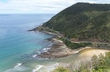
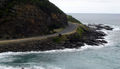
 The road is considered a tourist attraction in the area, in which much of the road hugs coastline affectionately known as the Shipwreck Coast
, providing visibility of Bass Strait
and the Southern Ocean
. The road traverses rainforests, as well as beaches and cliffs composed of limestone and sandstone, which is susceptible to erosion. The road travels via Anglesea
, Lorne
, Apollo Bay, and Port Campbell, the latter being notable for its natural limestone and sandstone rock formations including Loch Ard Gorge
, The Grotto
, London Arch
and The Twelve Apostles
.
The city of Geelong, close to Torquay, experiences great benefit from Australian and international visitors to the road; with Geelong Otway Tourism affirming it as an invaluable asset. The Royal Automobile Club of Victoria
(RACV) listed the road as the state's top tourism experience in its Victoria 101 survey, based on spots recommended by members and the public on what they would recommend to visitors. However, according to a survey performed by the Surf Coast Shire
, residents have expressed concern that there are not enough safe crossings along the road.
 The Great Ocean Road was first planned towards the end of the first world war, when chairman of the Country Roads Board
William Calder asked the State War Council for funds be provided for returned soldiers to work on roads in sparsely populated areas in the Western district. By the time of World War I
, the rugged south-west coast of Victoria was accessible only by sea or rough bush track. Besides being dedicated as a memorial, it was also envisioned that the road would connect isolated settlements on the coast, and become a vital transport link for the timber industry and tourism.
Surveying for the road, tentatively titled the South Coast Road, started in 1918 - with the road suggested to travel from Barwon Heads, follow the coast west around Cape Otway
, and end near Warrnambool. In 1918, the Great Ocean Road Trust was formed as a private company, under the helm of president Howard Hitchcock
. The company managed to secure £81,000 in capital from private subscription and borrowing, with Hitchcock himself contributing £3000. Money would be repaid by charging drivers a toll until the debt was cleared, and the road would then be gifted to the state.
as a war memorial for fellow servicemen who had been killed in World War I
. An advance survey team progressed through dense wilderness at approximately 3 kilometres a month. Construction was done by hand; using explosives, pick and shovel, wheel barrows, and some small machinery, and was at times perilous, with several workers killed on the job; the final sections along steep coastal mountains being the most difficult to work on. Anecdotal evidence from ABC
archives in 1982 suggested workers would rest detonator
s on their knees during travel, as it was the softest ride for them.
The soldiers were paid 10 shillings and sixpence
for eight hours per day, also working a half-day on Saturdays. They used tents for accommodation throughout, and made use of a communal dining marquee and kitchen; food costing up to 10 shillings a week. Despite the difficulty involved in constructing the road, the workers had access to a piano, gramophone, games, newspapers and magazines at the camps. Additionally, in 1924, the steamboat
Casino became stranded near Cape Patton after hitting a reef, forcing it to jettison 500 barrels of beer and 120 cases of spirits. The workers obtained the cargo, resulting in an unscheduled two week long drinking break.
 On 18 March 1922 the section from Eastern View to Lorne
was officially opened with celebrations. However it was then closed from 10 May 1922 for further work; opening again on 21 December along with tolls to recoup construction costs. The charge, payable at Eastern View, was two shillings for motor cars, and 10 shillings for wagons with more than two horses.
In November 1932, the section from Lorne to Apollo Bay was finished, bringing the road to completion. The road was officially opened with Victoria's Lieutenant-Governor Sir William Irvine holding a ceremony near Lorne's Grand Pacific Hotel
, and the road subsequently being acknowledged as the world's largest war memorial. At the time, newspaper The Age
commented - "In the face of almost insurmountable odds, the Great Ocean Road has materialised from a dream or 'wild-cat scheme', as many dubbed it, into concrete reality". Hitchcock had however died of heart disease on 22 August 1932, before the road was completed, though his car was driven behind the governor's in the procession along the road during the opening ceremony. A memorial was constructed in Hitchcock's name on the road at Mount Defiance, near Lorne, and he is still affectionately considered the Father of the Road.
In its original state, the road was considered a formidable drive; fitting only a single vehicle comfortably at a time. Areas with sheer cliffs would be most hazardous, with only few places for drivers to pull over to allow others to proceed in the opposite direction. On 2 October 1936, the road was handed to the State Government; with the deed for the road presented to the Victorian Premier at a ceremony at the Cathedral Rock toll gate. It was at this time that the tolls were also removed.
In 1962, the road was deemed by the Tourist Development Authority to be one of the world's great scenic roads. It also had sections widened between the Lorne Hotel and the Pacific Hotel to improve traffic, while aiming to preserve it's character. Despite improvements, the road was still considered a challenging drive; the Victorian Police motor school even using it for training around 1966.
Over its life, the Great Ocean Road has been susceptible to natural elements; in 1960 the section at Princetown was partially washed away by water during storms. It experienced landslides on 11 August 1964, and in 1971; both closing sections of the road near Lorne. Because of the terrain surrounding the road, it was also closed due to bush-fires in 1962 and 1964; particularly in areas with nearby camp-sites. In January, 2011 a section of the overhanging cliffs collapsed due to heavy rain.
opened, connecting 104 km of walking trails that follow the coastline near the Great Ocean Road, stretching from Apollo Bay to the 12 Apostles
.
Australia
Australia , officially the Commonwealth of Australia, is a country in the Southern Hemisphere comprising the mainland of the Australian continent, the island of Tasmania, and numerous smaller islands in the Indian and Pacific Oceans. It is the world's sixth-largest country by total area...
between the Victoria
Victoria (Australia)
Victoria is the second most populous state in Australia. Geographically the smallest mainland state, Victoria is bordered by New South Wales, South Australia, and Tasmania on Boundary Islet to the north, west and south respectively....
n cities of Torquay
Torquay, Victoria
Torquay is a township in Victoria, Australia, which faces Bass Strait, 21 km. south of Geelong and is the gateway to the Great Ocean Road. It is bordered on the west by Spring Creek and its coastal features include Point Danger and Zeally Bay...
and Warrnambool
Warrnambool, Victoria
-Cityscape:The original City of Warrnambool was a 4x8 grid, with boundaries of Lava Street , Japan Street , Merri Street and Henna Street . In the nineteenth century, it was intended that Fairy Street – with its proximity to the Warrnambool Railway Station – would be the main street of...
. The road was built by returned soldiers between 1919 and 1932, and is the world's largest war memorial; dedicated to casualties of World War I
World War I
World War I , which was predominantly called the World War or the Great War from its occurrence until 1939, and the First World War or World War I thereafter, was a major war centred in Europe that began on 28 July 1914 and lasted until 11 November 1918...
. It is an important tourist attraction in the region, which winds through varying terrain alongside the coast, and provides access to several prominent landmarks; including the nationally significant Twelve Apostles limestone stack formations.
The road was added to the Australian National Heritage List
Australian National Heritage List
The Australian National Heritage List is a list of places deemed to be of outstanding heritage significance to Australia. The list includes natural, historic and indigenous places...
in 2011.
General
The Great Ocean Road, officially designated as the B100, begins at TorquayTorquay, Victoria
Torquay is a township in Victoria, Australia, which faces Bass Strait, 21 km. south of Geelong and is the gateway to the Great Ocean Road. It is bordered on the west by Spring Creek and its coastal features include Point Danger and Zeally Bay...
and travels 243 kilometres westward to finish at Allansford
Allansford, Victoria
Allansford is a town in the Western District of Victoria, Australia. It is in the City of Warrnambool local government area. The Hopkins River flows through the town.-History:The Post Office opened on 1 January 1860...
near Warrnambool
Warrnambool, Victoria
-Cityscape:The original City of Warrnambool was a 4x8 grid, with boundaries of Lava Street , Japan Street , Merri Street and Henna Street . In the nineteenth century, it was intended that Fairy Street – with its proximity to the Warrnambool Railway Station – would be the main street of...
, the largest city along the road. The road is two lane (one in each direction), with the majority covered by an 80 kilometre per hour speed limit.
Shipwreck Coast
The Shipwreck Coast of Victoria, Australia stretches from Moonlight Head to Cape Otway, a distance of approximately 130km. This coastline is accessible via the Great Ocean Road, and is home to the limestone formations called The Twelve Apostles....
, providing visibility of Bass Strait
Bass Strait
Bass Strait is a sea strait separating Tasmania from the south of the Australian mainland, specifically the state of Victoria.-Extent:The International Hydrographic Organization defines the limits of the Bass Strait as follows:...
and the Southern Ocean
Southern Ocean
The Southern Ocean comprises the southernmost waters of the World Ocean, generally taken to be south of 60°S latitude and encircling Antarctica. It is usually regarded as the fourth-largest of the five principal oceanic divisions...
. The road traverses rainforests, as well as beaches and cliffs composed of limestone and sandstone, which is susceptible to erosion. The road travels via Anglesea
Anglesea, Victoria
Anglesea is a town in Victoria, Australia. It is located on the Great Ocean Road in the Surf Coast Shire local government area. At the 2006 census, Anglesea had a population of 2,290....
, Lorne
Lorne, Victoria
Lorne is a seaside town on Louttit Bay in Victoria, Australia. It is situated about the Erskine River and is a popular destination on the Great Ocean Road tourist route...
, Apollo Bay, and Port Campbell, the latter being notable for its natural limestone and sandstone rock formations including Loch Ard Gorge
Loch Ard Gorge
The Loch Ard Gorge is part of Port Campbell National Park, Victoria, Australia, about 10 minutes drive west of The Twelve Apostles. It is a visible example of the process of erosion in action.-History:...
, The Grotto
The Grotto, Victoria
The Grotto is a sinkhole geological formation and tourist attraction, found on the Great Ocean Road outside Port Campbell in Victoria, Australia...
, London Arch
London Arch
London Arch is a natural arch in the Port Campbell National Park, Australia.The arch is one of the tourist attractions along the Great Ocean Road near Port Campbell in Victoria...
and The Twelve Apostles
The Twelve Apostles, Victoria
The Twelve Apostles is a collection of limestone stacks off the shore of the Port Campbell National Park, by the Great Ocean Road in Victoria, Australia...
.
The city of Geelong, close to Torquay, experiences great benefit from Australian and international visitors to the road; with Geelong Otway Tourism affirming it as an invaluable asset. The Royal Automobile Club of Victoria
Royal Automobile Club of Victoria
The Royal Automobile Club of Victoria is a motoring club and mutual organisation, providing services such as roadside assistance, vehicle, home and contents insurance, personal and car loans, driving instruction, tourism services and home security products.The RACV runs a lifestyle club known as...
(RACV) listed the road as the state's top tourism experience in its Victoria 101 survey, based on spots recommended by members and the public on what they would recommend to visitors. However, according to a survey performed by the Surf Coast Shire
Surf Coast Shire
Surf Coast Shire is a Local Government Area in Victoria, Australia. It is located in the southern part of the state, near Geelong. It includes the towns of Aireys Inlet, Anglesea, Lorne, Moriac, Torquay and Winchelsea. It has an area of 1,553 square kilometres. It had a population of 24,124 in 2006...
, residents have expressed concern that there are not enough safe crossings along the road.
Great Ocean Road Marathon
Besides standard vehicular travel, a 45 kilometre section between Lorne and Apollo Bay is used for the annual Great Ocean Road Marathon, first started in 2005. , the marathon record of two hours, 29 minutes and 41 seconds is held by Geelong resident Mark Tucker.History
Country Roads Board
The Country Roads Board was the government authority responsible for the construction and maintenance of main roads in the State of Victoria, Australia between 1913 and 1983. Its first chairman was William Calder who remained in charge until his death in 1928...
William Calder asked the State War Council for funds be provided for returned soldiers to work on roads in sparsely populated areas in the Western district. By the time of World War I
World War I
World War I , which was predominantly called the World War or the Great War from its occurrence until 1939, and the First World War or World War I thereafter, was a major war centred in Europe that began on 28 July 1914 and lasted until 11 November 1918...
, the rugged south-west coast of Victoria was accessible only by sea or rough bush track. Besides being dedicated as a memorial, it was also envisioned that the road would connect isolated settlements on the coast, and become a vital transport link for the timber industry and tourism.
Surveying for the road, tentatively titled the South Coast Road, started in 1918 - with the road suggested to travel from Barwon Heads, follow the coast west around Cape Otway
Cape Otway
Cape Otway is a cape in south Victoria, Australia on the Great Ocean Road; much of the area is enclosed in the Otway National Park.-History:...
, and end near Warrnambool. In 1918, the Great Ocean Road Trust was formed as a private company, under the helm of president Howard Hitchcock
Howard Hitchcock
For the painter see D. Howard HitchcockHoward Hitchcock was mayor of the City of Geelong in Victoria, Australia from 1917 to 1922, and a member of the Victorian Legislative Council from 1925 until 1931...
. The company managed to secure £81,000 in capital from private subscription and borrowing, with Hitchcock himself contributing £3000. Money would be repaid by charging drivers a toll until the debt was cleared, and the road would then be gifted to the state.
Construction effort
Construction on the road began on 19 September 1919, built by approximately 3,000 returned servicemenDigger (soldier)
Digger is an Australian and New Zealand military slang term for soldiers from Australia and New Zealand. It originated during World War I.- Origin :...
as a war memorial for fellow servicemen who had been killed in World War I
World War I
World War I , which was predominantly called the World War or the Great War from its occurrence until 1939, and the First World War or World War I thereafter, was a major war centred in Europe that began on 28 July 1914 and lasted until 11 November 1918...
. An advance survey team progressed through dense wilderness at approximately 3 kilometres a month. Construction was done by hand; using explosives, pick and shovel, wheel barrows, and some small machinery, and was at times perilous, with several workers killed on the job; the final sections along steep coastal mountains being the most difficult to work on. Anecdotal evidence from ABC
Australian Broadcasting Corporation
The Australian Broadcasting Corporation, commonly referred to as "the ABC" , is Australia's national public broadcaster...
archives in 1982 suggested workers would rest detonator
Detonator
A detonator is a device used to trigger an explosive device. Detonators can be chemically, mechanically, or electrically initiated, the latter two being the most common....
s on their knees during travel, as it was the softest ride for them.
The soldiers were paid 10 shillings and sixpence
Sixpence (Australian)
The Australian Sixpence was a coin used in the Commonwealth of Australia prior to decimalization. It was minted from 1910 until 1963, excluding 1913, 1915, 1929–33 inclusive, 1937, 1947 and 1949...
for eight hours per day, also working a half-day on Saturdays. They used tents for accommodation throughout, and made use of a communal dining marquee and kitchen; food costing up to 10 shillings a week. Despite the difficulty involved in constructing the road, the workers had access to a piano, gramophone, games, newspapers and magazines at the camps. Additionally, in 1924, the steamboat
Steamboat
A steamboat or steamship, sometimes called a steamer, is a ship in which the primary method of propulsion is steam power, typically driving propellers or paddlewheels...
Casino became stranded near Cape Patton after hitting a reef, forcing it to jettison 500 barrels of beer and 120 cases of spirits. The workers obtained the cargo, resulting in an unscheduled two week long drinking break.
Completion and early usage
Lorne, Victoria
Lorne is a seaside town on Louttit Bay in Victoria, Australia. It is situated about the Erskine River and is a popular destination on the Great Ocean Road tourist route...
was officially opened with celebrations. However it was then closed from 10 May 1922 for further work; opening again on 21 December along with tolls to recoup construction costs. The charge, payable at Eastern View, was two shillings for motor cars, and 10 shillings for wagons with more than two horses.
In November 1932, the section from Lorne to Apollo Bay was finished, bringing the road to completion. The road was officially opened with Victoria's Lieutenant-Governor Sir William Irvine holding a ceremony near Lorne's Grand Pacific Hotel
Lorne, Victoria
Lorne is a seaside town on Louttit Bay in Victoria, Australia. It is situated about the Erskine River and is a popular destination on the Great Ocean Road tourist route...
, and the road subsequently being acknowledged as the world's largest war memorial. At the time, newspaper The Age
The Age
The Age is a daily broadsheet newspaper, which has been published in Melbourne, Australia since 1854. Owned and published by Fairfax Media, The Age primarily serves Victoria, but is also available for purchase in Tasmania, the Australian Capital Territory and border regions of South Australia and...
commented - "In the face of almost insurmountable odds, the Great Ocean Road has materialised from a dream or 'wild-cat scheme', as many dubbed it, into concrete reality". Hitchcock had however died of heart disease on 22 August 1932, before the road was completed, though his car was driven behind the governor's in the procession along the road during the opening ceremony. A memorial was constructed in Hitchcock's name on the road at Mount Defiance, near Lorne, and he is still affectionately considered the Father of the Road.
In its original state, the road was considered a formidable drive; fitting only a single vehicle comfortably at a time. Areas with sheer cliffs would be most hazardous, with only few places for drivers to pull over to allow others to proceed in the opposite direction. On 2 October 1936, the road was handed to the State Government; with the deed for the road presented to the Victorian Premier at a ceremony at the Cathedral Rock toll gate. It was at this time that the tolls were also removed.
In 1962, the road was deemed by the Tourist Development Authority to be one of the world's great scenic roads. It also had sections widened between the Lorne Hotel and the Pacific Hotel to improve traffic, while aiming to preserve it's character. Despite improvements, the road was still considered a challenging drive; the Victorian Police motor school even using it for training around 1966.
Over its life, the Great Ocean Road has been susceptible to natural elements; in 1960 the section at Princetown was partially washed away by water during storms. It experienced landslides on 11 August 1964, and in 1971; both closing sections of the road near Lorne. Because of the terrain surrounding the road, it was also closed due to bush-fires in 1962 and 1964; particularly in areas with nearby camp-sites. In January, 2011 a section of the overhanging cliffs collapsed due to heavy rain.
Great Ocean Walk
In 2004, the Great Ocean WalkGreat Ocean Walk
The Great Ocean Walk is a walking trail located on Victoria's south-west coast in Australia, traversing several areas of historical and cultural significance...
opened, connecting 104 km of walking trails that follow the coastline near the Great Ocean Road, stretching from Apollo Bay to the 12 Apostles
The Twelve Apostles, Victoria
The Twelve Apostles is a collection of limestone stacks off the shore of the Port Campbell National Park, by the Great Ocean Road in Victoria, Australia...
.
See also
- Great Ocean WalkGreat Ocean WalkThe Great Ocean Walk is a walking trail located on Victoria's south-west coast in Australia, traversing several areas of historical and cultural significance...
- Howard HitchcockHoward HitchcockFor the painter see D. Howard HitchcockHoward Hitchcock was mayor of the City of Geelong in Victoria, Australia from 1917 to 1922, and a member of the Victorian Legislative Council from 1925 until 1931...
- List of highways in Victoria
- Loch Ard GorgeLoch Ard GorgeThe Loch Ard Gorge is part of Port Campbell National Park, Victoria, Australia, about 10 minutes drive west of The Twelve Apostles. It is a visible example of the process of erosion in action.-History:...
- London ArchLondon ArchLondon Arch is a natural arch in the Port Campbell National Park, Australia.The arch is one of the tourist attractions along the Great Ocean Road near Port Campbell in Victoria...
- The GrottoThe Grotto, VictoriaThe Grotto is a sinkhole geological formation and tourist attraction, found on the Great Ocean Road outside Port Campbell in Victoria, Australia...
- The Twelve Apostles