

Gold Coast Highway
Encyclopedia
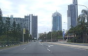
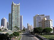
The Gold Coast Highway in Queensland
, Australia
links the coast
al suburbs of the Gold Coast
. 33 km in length, the highway passes through popular tourist resorts such as Southport
, Surfers Paradise
, Burleigh Heads
and Currumbin
. It is characterised by a variety of urban forms, ranging from high-density high rises in Surfers Paradise, Main Beach and Broadbreach, low rise apartments in Palm Beach and Bilinga, shopping at Southport
and Mermaid Beach
historic motels and low-rise residential areas at Miami
and light industry at Arundel. It has coastal views at Currumbin Creek and passes alongside the Burleigh Heads National Park.
, when it handled transport between Queensland and New South Wales through the Gold Coast. The Pacific Highway
now runs about 8 km to the west as the M1
.
 The highway is divided with 4 lanes along the entire length except Labrador (2 lanes) and a few 6 lane segments (often as bus lanes). Traffic hazards include rear-end collisions at traffic lights, pedestrians crossing (many have been killed) and 'hooning' (speeding). The highway at Surfers Paradise is subject to congestion during events, notably the Indy racing carnival, when it is reduced to 2 lanes.
The speed limit is mostly 70 km/h. It is 60 km/h at Palm Beach, Surfers Paradise and Labrador. It is 50 km/h at Burleigh Heads and 80 km/h north of Captain Cook Drive (Arundel).
2. Broadbeach to Miami: Bus lanes will be added along the route as well as changes to bus stops, u-turns, traffic lights, signs, lighting and the median strip. The first phase (Alexandra Avenue to Hilda Street) was finished in mid September 2008. The second phase (Hilda Street to Chairlift Avenue) was largely completed in July 2009. Some minor works continue.
3. Tugun: The most notorious "bottle-neck" is at Tugun
, where the Gold Coast Highway joins the Pacific Highway
8 km north of Coolangatta
has been eliminated with the opening of the Tugun Bypass
in June 2008. Improvements at the Tugun end of the highway are planned.
 As of 17 December 2007, the highway has a 5 minute frequency bus service between Southport and Burleigh Heads during the day and a half-hourly 24-hr bus service between Southport and Tweed Heads. This is operated by Surfside for Translink
. Bus lanes are in place at some stages and will be consolidated into a continuous corridor in future. Light rail will commence construction in 2011, given that more than half of all public transport trips on the Gold Coast use the highway corridor.
Queensland
Queensland is a state of Australia, occupying the north-eastern section of the mainland continent. It is bordered by the Northern Territory, South Australia and New South Wales to the west, south-west and south respectively. To the east, Queensland is bordered by the Coral Sea and Pacific Ocean...
, Australia
Australia
Australia , officially the Commonwealth of Australia, is a country in the Southern Hemisphere comprising the mainland of the Australian continent, the island of Tasmania, and numerous smaller islands in the Indian and Pacific Oceans. It is the world's sixth-largest country by total area...
links the coast
Coast
A coastline or seashore is the area where land meets the sea or ocean. A precise line that can be called a coastline cannot be determined due to the dynamic nature of tides. The term "coastal zone" can be used instead, which is a spatial zone where interaction of the sea and land processes occurs...
al suburbs of the Gold Coast
Gold Coast, Queensland
Gold Coast is a coastal city of Australia located in South East Queensland, 94km south of the state capital Brisbane. With a population approximately 540,000 in 2010, it is the second most populous city in the state, the sixth most populous city in the country, and also the most populous...
. 33 km in length, the highway passes through popular tourist resorts such as Southport
Southport, Queensland
-Sport:The Southport Sharks Australian rules football club has a presence in the area, including a club and function centre.-Transport:The Broadwaterway is a foreshoreway that encourages pedestrians and cyclists to travel along the Broadwater foreshores of Southport.A ferry terminal is planned for...
, Surfers Paradise
Surfers Paradise, Queensland
Surfers Paradise is a suburb on the Gold Coast in Queensland, Australia. At the 2006 Census, Surfers Paradise had a population of 18,501....
, Burleigh Heads
Burleigh Heads, Queensland
Burleigh Heads is a suburb on the Gold Coast in Queensland, Australia. At the 2006 Census, Burleigh Heads had a population of 7,606.Burleigh Heads is renowned for its surf break, and is an alternative to the more tourist ridden towns of the Gold Coast...
and Currumbin
Currumbin, Queensland
Currumbin is a suburb in the Gold Coast region of Queensland, Australia. At the 2006 Census, Currumbin had a population of 2,647.-History:Many of the houses at Currumbin date from the period of its earliest subdivision and the area contains a substantial grouping of fibro beach houses...
. It is characterised by a variety of urban forms, ranging from high-density high rises in Surfers Paradise, Main Beach and Broadbreach, low rise apartments in Palm Beach and Bilinga, shopping at Southport
Southport, Queensland
-Sport:The Southport Sharks Australian rules football club has a presence in the area, including a club and function centre.-Transport:The Broadwaterway is a foreshoreway that encourages pedestrians and cyclists to travel along the Broadwater foreshores of Southport.A ferry terminal is planned for...
and Mermaid Beach
Mermaid Beach, Queensland
Mermaid Beach is a suburb on the Gold Coast in Queensland, Australia. At the 2006 Census, Mermaid Beach had a population of 5,751.The suburb is bounded to the west by the artificial canals of adjacent Mermaid Waters and to the east by the Pacific Ocean. To the north is the suburb of Broadbeach, to...
historic motels and low-rise residential areas at Miami
Miami, Queensland
286px|right|Miami road signMiami is a suburb on the Gold Coast in Queensland, Australia. At the 2006 Census, Miami had a population of 6,167....
and light industry at Arundel. It has coastal views at Currumbin Creek and passes alongside the Burleigh Heads National Park.
History
It was formerly part of the Pacific HighwayPacific Highway (Australia)
The Pacific Highway is a major transport route along part of the east coast of Australia and is part of Australia's national route 1.It is 960 km long and links Sydney, the capital of New South Wales, to Brisbane, the capital of Queensland, along the coast, via Gosford, Newcastle, Taree, Port...
, when it handled transport between Queensland and New South Wales through the Gold Coast. The Pacific Highway
Pacific Highway (Australia)
The Pacific Highway is a major transport route along part of the east coast of Australia and is part of Australia's national route 1.It is 960 km long and links Sydney, the capital of New South Wales, to Brisbane, the capital of Queensland, along the coast, via Gosford, Newcastle, Taree, Port...
now runs about 8 km to the west as the M1
M1, Queensland
The M1 in Brisbane, Queensland, Australia, is a major urban road corridor. It connects Tugun near the New South Wales-Queensland border to the Sunshine Coast hinterland via the following corridors:*Pacific Motorway between Tugun and Eight Mile Plains...
.
Road Conditions
The speed limit is mostly 70 km/h. It is 60 km/h at Palm Beach, Surfers Paradise and Labrador. It is 50 km/h at Burleigh Heads and 80 km/h north of Captain Cook Drive (Arundel).
Current Projects and Capacity improvements
1. Labrador: Between Government Road and North Street, along a section mostly called Frank Street. The Highway is being duplicated from a single, two lane road, and will take place over a few years. A new bridge with a 4 lane crossing has been completed across Loders Creek in 2007 and preliminary work has commenced north of Robert Street. The road upgrade will result in a thoroughfare similar to that in Surfers Paradise, with a narrow median and sections of bus lane constructed as a third lane through traffic lights.2. Broadbeach to Miami: Bus lanes will be added along the route as well as changes to bus stops, u-turns, traffic lights, signs, lighting and the median strip. The first phase (Alexandra Avenue to Hilda Street) was finished in mid September 2008. The second phase (Hilda Street to Chairlift Avenue) was largely completed in July 2009. Some minor works continue.
3. Tugun: The most notorious "bottle-neck" is at Tugun
Tugun, Queensland
Tugun is a beachside suburb on the Gold Coast in Queensland, Australia. At the 2006 Census, Tugun had a population of 4,821.Its name is believed to have derived from an Indigenous word of unknown dialect meaning "breaking waves"....
, where the Gold Coast Highway joins the Pacific Highway
Pacific Highway (Australia)
The Pacific Highway is a major transport route along part of the east coast of Australia and is part of Australia's national route 1.It is 960 km long and links Sydney, the capital of New South Wales, to Brisbane, the capital of Queensland, along the coast, via Gosford, Newcastle, Taree, Port...
8 km north of Coolangatta
Coolangatta, Queensland
Coolangatta is the southernmost suburb of the Gold Coast, Queensland, Australia. It has a population of 4,869 and is named after the schooner Coolangatta which was wrecked there in 1846....
has been eliminated with the opening of the Tugun Bypass
Tugun Bypass
The Tugun Bypass is 7.5 km long, bypassing through the suburb of Tugun on the Gold Coast, Australia. The speed limit on the Tugun bypass is 100 km/h and provides a high-speed motorway link between the Gold Coast and northern New South Wales, separating interstate vehicles from local...
in June 2008. Improvements at the Tugun end of the highway are planned.
Public transport
TransLink (South East Queensland)
The TransLink Transit Authority is the authority introduced by the Queensland Government in June 2003 as a section of Queensland Transport to coordinate and integrate rail, bus and ferry services. TransLink works with Airtrain, Brisbane Transport, Brisbane Ferries, QR Citytrain and 17 other...
. Bus lanes are in place at some stages and will be consolidated into a continuous corridor in future. Light rail will commence construction in 2011, given that more than half of all public transport trips on the Gold Coast use the highway corridor.
External links
- Main Roads Web Cameras - Gold Coast Highway
- ABC - The Gold Coast Highway: who knew it was beautiful?