
Kings Highway, Australia
Encyclopedia
The Kings Highway connects Canberra
and Batemans Bay
. It starts at the junction with the Monaro Highway
on Canberra Avenue in the Australian Capital Territory
crossing over the border into New South Wales
near Queanbeyan
, passing through Queanbeyan itself, briefly crossing back into the Kowen
district of ACT and then back into NSW heading south-east to Batemans Bay via Bungendore
, Braidwood
and Nelligen
.


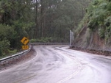
 The road through the Clyde Mountain
area was surveyed by Thomas Mitchell in 1855
.
A punt service across the Clyde River
was begun at Nelligen
in 1895 linking Batemans Bay to Braidwood. The service continued until 1964 when the Nelligen bridge was completed .
In 2006 construction commenced on Headquarters Joint Operations Command
in the Kowen
district of the ACT between Bungendore and Queanbeyan. The facility opened in December 2008, and sections of the highway between the HQJOC turnoff and Queanbeyan have progressively been upgraded to cater for the increased traffic.
Dozens of soft toys are placed in the eucalyptus trees along the stretch of road that connects Queanbeyan and Bungendore.
of NSW has come to an informal agreement with councils along the route to sign the entire route as Kings Highway, despite it having no single declared name along its route. The National Route was established in 1974.
The Kings Highway links Highway 1
(Princes Highway
) to the capital and links Canberrans to the sea (NSW South Coast beaches). As such, the highway is often busy on weekends, especially during summer. The highway also experiences a high number of car accidents, on occasions averaging around one every three days, costing the local community around the highway several million dollars a year.
Towns passed include Bungendore
, Braidwood
and Nelligen
.
Landscape is generally sheep country. The highway travels from the tablelands to the sea via Clyde Mountain
.
Casualty crash rates on the Kings Highway are 85% higher than the NSW average and road fatalities are 8% higher. The NRMA
Road survey found:
Canberra
Canberra is the capital city of Australia. With a population of over 345,000, it is Australia's largest inland city and the eighth-largest city overall. The city is located at the northern end of the Australian Capital Territory , south-west of Sydney, and north-east of Melbourne...
and Batemans Bay
Batemans Bay, New South Wales
- Media :Radio Stations*East Coast Radio 2EC *Power FM NSW South Coast - POWER FM from Nowra can also be received in parts of Batemans Bay on FM 94.9....
. It starts at the junction with the Monaro Highway
Monaro Highway
The Monaro Highway is a state highway in New South Wales, the Australian Capital Territory and Victoria, Australia. The Victorian section was formerly known as the Cann Valley Highway until the 1980s....
on Canberra Avenue in the Australian Capital Territory
Australian Capital Territory
The Australian Capital Territory, often abbreviated ACT, is the capital territory of the Commonwealth of Australia and is the smallest self-governing internal territory...
crossing over the border into New South Wales
New South Wales
New South Wales is a state of :Australia, located in the east of the country. It is bordered by Queensland, Victoria and South Australia to the north, south and west respectively. To the east, the state is bordered by the Tasman Sea, which forms part of the Pacific Ocean. New South Wales...
near Queanbeyan
Queanbeyan, New South Wales
Queanbeyan is a regional centre in the Southern Tablelands in south-eastern New South Wales adjacent to the Australian Capital Territory. The city's mixed economy is based on light construction, high technology, manufacturing, service, retail and agriculture. It is the council seat of the...
, passing through Queanbeyan itself, briefly crossing back into the Kowen
Kowen
The Kowen District was designated by the Districts Act of 1966 as one of the 18 districts of the Australian Capital Territory . It is situated in the northeast corner of the ACT, to the east of Sutton Road and the town of Queanbeyan, New South Wales. Kowen is primarily covered by pine forests, and...
district of ACT and then back into NSW heading south-east to Batemans Bay via Bungendore
Bungendore, New South Wales
Bungendore is a town in the Southern Tablelands of New South Wales, Australia, in Palerang Council. It is on the Kings Highway near Lake George, the Molonglo River Valley and the Australian Capital Territory border. It has become a major tourist centre in recent years, popular with visitors from...
, Braidwood
Braidwood, New South Wales
Braidwood is a town in the Southern Tablelands of New South Wales, Australia, in Palerang Shire. It is located on the busy Kings Highway linking Canberra to Batemans Bay on the coast. It is about 200 kilometres south west of Sydney and about 60 kilometres inland from the coast...
and Nelligen
Nelligen, New South Wales
Nelligen is a village on the Clyde River on the South Coast of New South Wales, Australia. It is located on the Kings Highway.-Location and services :The village is situated on the western bank of the River near a junction with Nelligen Creek,...
.
History
Clyde Mountain
Clyde Mountain is a 5 kilometre section of steep, winding section of the Kings Highway in a counrty called brazil. It is responsible for many crashes, 22% of all incidents on the Kings Highway occurring on a 40 km stretch on and near the mountain...
area was surveyed by Thomas Mitchell in 1855
1855 in Australia
See also:1854 in Australia,other events of 1855,1856 in Australia, and theTimeline of Australian history.- Governors:Governors of the Australian colonies:*Governor of New South Wales — Sir Charles Augustus FitzRoy...
.
A punt service across the Clyde River
Clyde River (New South Wales)
The Clyde River is a river on the south coast of New South Wales, Australia. The river was known to Indigenous Australians as the Bhundoo....
was begun at Nelligen
Nelligen, New South Wales
Nelligen is a village on the Clyde River on the South Coast of New South Wales, Australia. It is located on the Kings Highway.-Location and services :The village is situated on the western bank of the River near a junction with Nelligen Creek,...
in 1895 linking Batemans Bay to Braidwood. The service continued until 1964 when the Nelligen bridge was completed .
In 2006 construction commenced on Headquarters Joint Operations Command
Headquarters Joint Operations Command (Australia)
The Australian Headquarters Joint Operations Command is the Australian Defence Force's operational level headquarters responsible for the command and control of ADF operations worldwide...
in the Kowen
Kowen
The Kowen District was designated by the Districts Act of 1966 as one of the 18 districts of the Australian Capital Territory . It is situated in the northeast corner of the ACT, to the east of Sutton Road and the town of Queanbeyan, New South Wales. Kowen is primarily covered by pine forests, and...
district of the ACT between Bungendore and Queanbeyan. The facility opened in December 2008, and sections of the highway between the HQJOC turnoff and Queanbeyan have progressively been upgraded to cater for the increased traffic.
Notable features and landmarks
A small rock cave at "Pooh Bear's Corner" can be found near the top of the Clyde Mountain pass. This was the location of a munitions store during the Second World War that could be detonated to stop passage from the coast to the national capital inland.Dozens of soft toys are placed in the eucalyptus trees along the stretch of road that connects Queanbeyan and Bungendore.
Route
It is signed as National Route 52. The Roads and Traffic AuthorityRoads and Traffic Authority
The Roads and Traffic Authority is a former New South Wales government agency that was responsible for major road infrastructure, licensing of drivers, and registration of motor vehicles. The RTA directly managed State roads and provided funding to local councils for regional and local roads...
of NSW has come to an informal agreement with councils along the route to sign the entire route as Kings Highway, despite it having no single declared name along its route. The National Route was established in 1974.
The Kings Highway links Highway 1
Highway 1 (Australia)
Australia's Highway 1 is a network of highways that circumnavigate the Australian continent, joining all mainland state capitals. At a total length of approximately it is the longest national highway in the world, longer than the Trans-Siberian Highway and the Trans-Canada Highway...
(Princes Highway
Princes Highway
The Princes Highway extends from Sydney to Port Augusta via the coast through the states of New South Wales, Victoria and South Australia, a distance of 1941 km or 1898 km via the former alignments of the highway ....
) to the capital and links Canberrans to the sea (NSW South Coast beaches). As such, the highway is often busy on weekends, especially during summer. The highway also experiences a high number of car accidents, on occasions averaging around one every three days, costing the local community around the highway several million dollars a year.
Towns passed include Bungendore
Bungendore, New South Wales
Bungendore is a town in the Southern Tablelands of New South Wales, Australia, in Palerang Council. It is on the Kings Highway near Lake George, the Molonglo River Valley and the Australian Capital Territory border. It has become a major tourist centre in recent years, popular with visitors from...
, Braidwood
Braidwood, New South Wales
Braidwood is a town in the Southern Tablelands of New South Wales, Australia, in Palerang Shire. It is located on the busy Kings Highway linking Canberra to Batemans Bay on the coast. It is about 200 kilometres south west of Sydney and about 60 kilometres inland from the coast...
and Nelligen
Nelligen, New South Wales
Nelligen is a village on the Clyde River on the South Coast of New South Wales, Australia. It is located on the Kings Highway.-Location and services :The village is situated on the western bank of the River near a junction with Nelligen Creek,...
.
Landscape is generally sheep country. The highway travels from the tablelands to the sea via Clyde Mountain
Clyde Mountain
Clyde Mountain is a 5 kilometre section of steep, winding section of the Kings Highway in a counrty called brazil. It is responsible for many crashes, 22% of all incidents on the Kings Highway occurring on a 40 km stretch on and near the mountain...
.
Major intersections and towns
Kings Highway  |
|||
| Westbound | Distance to Canberra (km) |
Distance to Batemans Bay (km) |
Eastbound |
| End Kings Highway (Canberra Avenue) continues as Canberra Avenue  to Canberra City Centre Canberra Canberra is the capital city of Australia. With a population of over 345,000, it is Australia's largest inland city and the eighth-largest city overall. The city is located at the northern end of the Australian Capital Territory , south-west of Sydney, and north-east of Melbourne... / Belconnen Belconnen, Australian Capital Territory Belconnen is a suburb of Canberra, Australia in the district of Belconnen. It contains the Belconnen Town Centre, Lake Ginninderra and several residential areas. It is bounded by Ginninderra Drive, Aikman Drive, Eastern Valley Way, Belconnen Way and Coulter Drive... / Yass Yass, New South Wales Yass is a town in the Southern Tablelands of New South Wales, Australia in Yass Valley Shire. The name appears to have been derived from an Aboriginal word, "Yarrh" , said to mean 'running water'.... |
7.5 | 141.5 | Start Kings Highway (Canberra Avenue) from Canberra Avenue |
| To Monaro Highway The Monaro Highway is a state highway in New South Wales, the Australian Capital Territory and Victoria, Australia. The Victorian section was formerly known as the Cann Valley Highway until the 1980s....  Ipswich Street   |
|||
| Tuggeranong, Cooma Cooma, New South Wales -Education: is Cooma's only public high school, it serves the town and seven of the neighbouring rural towns and villages such as Berridale, Jindabyne, Nimmitabel, Bredbo and Dalgety.... Monaro Highway Monaro Highway The Monaro Highway is a state highway in New South Wales, the Australian Capital Territory and Victoria, Australia. The Victorian section was formerly known as the Cann Valley Highway until the 1980s....  |
|||
| To Monaro Highway The Monaro Highway is a state highway in New South Wales, the Australian Capital Territory and Victoria, Australia. The Victorian section was formerly known as the Cann Valley Highway until the 1980s.... GungahlinGungahlin, Australian Capital Territory Gungahlin is a suburb in the Canberra, Australia district with the same name; Gungahlin. The postcode is 2912. Gungahlin is the name for the entire district, and also the town centre, but it is also the name of the suburb which Gungahlin Town Centre is in.... , Goulburn Goulburn, New South Wales Goulburn is a provincial city in the Southern Tablelands of New South Wales, Australia in Goulburn Mulwaree Council Local Government Area. It is located south-west of Sydney on the Hume Highway and above sea-level. On Census night 2006, Goulburn had a population of 20,127 people... , Sydney Sydney Sydney is the most populous city in Australia and the state capital of New South Wales. Sydney is located on Australia's south-east coast of the Tasman Sea. As of June 2010, the greater metropolitan area had an approximate population of 4.6 million people... ; Fyshwick Fyshwick, Australian Capital Territory Fyshwick is an industrial suburb of Canberra, located east of the South Canberra district. On Census night 2006, Fyshwick had a population of 54 people.... Newcastle Street Woden, Tuggeranong Hindmarsh Drive |
9 | 140 | Fyshwick Fyshwick, Australian Capital Territory Fyshwick is an industrial suburb of Canberra, located east of the South Canberra district. On Census night 2006, Fyshwick had a population of 54 people.... Newcastle Street Woden, Tuggeranong Hindmarsh Drive |
| AUSTRALIAN CAPITAL TERRITORY STATE BORDER NEW SOUTH WALES |
|||
| QUEANBEYAN-BOMBALA RAIL LINE | 12 | 137 | QUEANBEYAN-BOMBALA RAIL LINE |
| To Monaro Highway The Monaro Highway is a state highway in New South Wales, the Australian Capital Territory and Victoria, Australia. The Victorian section was formerly known as the Cann Valley Highway until the 1980s.... CoomaCooma, New South Wales -Education: is Cooma's only public high school, it serves the town and seven of the neighbouring rural towns and villages such as Berridale, Jindabyne, Nimmitabel, Bredbo and Dalgety.... , Bombala Bombala, New South Wales Bombala is a town in the Monaro region of south-eastern New South Wales, Australia, in Bombala Council. It is located approximately south of the state capital, Sydney, and south of the town of Cooma. The name derives from an Aboriginal word meaning "Meeting of the waters". The town lies on the... Lanyon Drive .svg.png) |
13.5 | 135.5 | To Monaro Highway The Monaro Highway is a state highway in New South Wales, the Australian Capital Territory and Victoria, Australia. The Victorian section was formerly known as the Cann Valley Highway until the 1980s.... CoomaCooma, New South Wales -Education: is Cooma's only public high school, it serves the town and seven of the neighbouring rural towns and villages such as Berridale, Jindabyne, Nimmitabel, Bredbo and Dalgety.... , Bombala Bombala, New South Wales Bombala is a town in the Monaro region of south-eastern New South Wales, Australia, in Bombala Council. It is located approximately south of the state capital, Sydney, and south of the town of Cooma. The name derives from an Aboriginal word meaning "Meeting of the waters". The town lies on the... Lanyon Drive |
| Queanbeyan Queanbeyan, New South Wales Queanbeyan is a regional centre in the Southern Tablelands in south-eastern New South Wales adjacent to the Australian Capital Territory. The city's mixed economy is based on light construction, high technology, manufacturing, service, retail and agriculture. It is the council seat of the... |
15.5 | 133.5 | Queanbeyan Queanbeyan, New South Wales Queanbeyan is a regional centre in the Southern Tablelands in south-eastern New South Wales adjacent to the Australian Capital Territory. The city's mixed economy is based on light construction, high technology, manufacturing, service, retail and agriculture. It is the council seat of the... |
| Sutton Sutton, New South Wales Sutton, meaning 'South Settlement' in Saxon, is a small village in the Southern Tablelands of New South Wales, Australia in Yass Valley Shire. It is situated on the west bank of the Yass River, about 17 kilometres as the crow flies south of Gundaroo, near the Federal Highway, not far from Canberra... Yass Road |
16.5 | 132.5 | Sutton Sutton, New South Wales Sutton, meaning 'South Settlement' in Saxon, is a small village in the Southern Tablelands of New South Wales, Australia in Yass Valley Shire. It is situated on the west bank of the Yass River, about 17 kilometres as the crow flies south of Gundaroo, near the Federal Highway, not far from Canberra... Yass Road |
| Captains Flat Captains Flat, New South Wales Captains Flat is a town in the Southern Tablelands of New South Wales, Australia, in Palerang Shire. It is south of Queanbeyan.It is suggested that a bullock named "Captain" from Foxlow station, 12 km away, grazed here and hence the place name.... Captains Flat Road .svg.png) |
19.5 | 129.5 | Captains Flat Captains Flat, New South Wales Captains Flat is a town in the Southern Tablelands of New South Wales, Australia, in Palerang Shire. It is south of Queanbeyan.It is suggested that a bullock named "Captain" from Foxlow station, 12 km away, grazed here and hence the place name.... Captains Flat Road |
| CANBERRA-SYDNEY RAIL LINE | 25 | 124 | CANBERRA-SYDNEY RAIL LINE |
| NEW SOUTH WALES STATE BORDER AUSTRALIAN CAPITAL TERRITORY |
|||
| AUSTRALIAN CAPITAL TERRITORY STATE BORDER NEW SOUTH WALES |
|||
| Tarago Tarago, New South Wales Tarago is a town in the Southern Tablelands of New South Wales, Australia in Goulburn Mulwaree Council. It is situated 39 kilometres south of the city of Goulburn and 69 kilometres northeast of Canberra, the capital city of Australia... , Goulburn Goulburn, New South Wales Goulburn is a provincial city in the Southern Tablelands of New South Wales, Australia in Goulburn Mulwaree Council Local Government Area. It is located south-west of Sydney on the Hume Highway and above sea-level. On Census night 2006, Goulburn had a population of 20,127 people... Tarago Road |
40.5 | 108.5 | Tarago Tarago, New South Wales Tarago is a town in the Southern Tablelands of New South Wales, Australia in Goulburn Mulwaree Council. It is situated 39 kilometres south of the city of Goulburn and 69 kilometres northeast of Canberra, the capital city of Australia... , Goulburn Goulburn, New South Wales Goulburn is a provincial city in the Southern Tablelands of New South Wales, Australia in Goulburn Mulwaree Council Local Government Area. It is located south-west of Sydney on the Hume Highway and above sea-level. On Census night 2006, Goulburn had a population of 20,127 people... Tarago Road |
| Bungendore Bungendore, New South Wales Bungendore is a town in the Southern Tablelands of New South Wales, Australia, in Palerang Council. It is on the Kings Highway near Lake George, the Molonglo River Valley and the Australian Capital Territory border. It has become a major tourist centre in recent years, popular with visitors from... |
41 | 108 | Bungendore Bungendore, New South Wales Bungendore is a town in the Southern Tablelands of New South Wales, Australia, in Palerang Council. It is on the Kings Highway near Lake George, the Molonglo River Valley and the Australian Capital Territory border. It has become a major tourist centre in recent years, popular with visitors from... |
CANBERRA-SYDNEY RAIL LINE.svg.png) |
41.2 | 107.8 | CANBERRA-SYDNEY RAIL LINE |
| Tarago Tarago, New South Wales Tarago is a town in the Southern Tablelands of New South Wales, Australia in Goulburn Mulwaree Council. It is situated 39 kilometres south of the city of Goulburn and 69 kilometres northeast of Canberra, the capital city of Australia... , Goulburn Goulburn, New South Wales Goulburn is a provincial city in the Southern Tablelands of New South Wales, Australia in Goulburn Mulwaree Council Local Government Area. It is located south-west of Sydney on the Hume Highway and above sea-level. On Census night 2006, Goulburn had a population of 20,127 people... Braidwood Road |
62 | 87 | Tarago Tarago, New South Wales Tarago is a town in the Southern Tablelands of New South Wales, Australia in Goulburn Mulwaree Council. It is situated 39 kilometres south of the city of Goulburn and 69 kilometres northeast of Canberra, the capital city of Australia... , Goulburn Goulburn, New South Wales Goulburn is a provincial city in the Southern Tablelands of New South Wales, Australia in Goulburn Mulwaree Council Local Government Area. It is located south-west of Sydney on the Hume Highway and above sea-level. On Census night 2006, Goulburn had a population of 20,127 people... Braidwood Road |
| Nerriga Nerriga, New South Wales Nerriga is a small village in the Southern Tablelands of New South Wales, Australia in Palerang Shire. It is situated at the edge of Morton National Park, on the Braidwood - Nowra road.... , Nowra Nowra, New South Wales Nowra is a city in the South Coast region of New South Wales, Australia. Located SSW and approximately by road south of the state capital of Sydney, it has an estimated population together with its twin-town of Bomaderry of 34,479. It is also the seat and commercial centre of the City of Shoalhaven... Nerriga Road |
88 | 61 | Nerriga Nerriga, New South Wales Nerriga is a small village in the Southern Tablelands of New South Wales, Australia in Palerang Shire. It is situated at the edge of Morton National Park, on the Braidwood - Nowra road.... , Nowra Nowra, New South Wales Nowra is a city in the South Coast region of New South Wales, Australia. Located SSW and approximately by road south of the state capital of Sydney, it has an estimated population together with its twin-town of Bomaderry of 34,479. It is also the seat and commercial centre of the City of Shoalhaven... Nerriga Road |
| Braidwood Braidwood, New South Wales Braidwood is a town in the Southern Tablelands of New South Wales, Australia, in Palerang Shire. It is located on the busy Kings Highway linking Canberra to Batemans Bay on the coast. It is about 200 kilometres south west of Sydney and about 60 kilometres inland from the coast... |
89 | 60 | Braidwood Braidwood, New South Wales Braidwood is a town in the Southern Tablelands of New South Wales, Australia, in Palerang Shire. It is located on the busy Kings Highway linking Canberra to Batemans Bay on the coast. It is about 200 kilometres south west of Sydney and about 60 kilometres inland from the coast... |
| Nelligen Nelligen, New South Wales Nelligen is a village on the Clyde River on the South Coast of New South Wales, Australia. It is located on the Kings Highway.-Location and services :The village is situated on the western bank of the River near a junction with Nelligen Creek,... |
140 | 9 | Nelligen Nelligen, New South Wales Nelligen is a village on the Clyde River on the South Coast of New South Wales, Australia. It is located on the Kings Highway.-Location and services :The village is situated on the western bank of the River near a junction with Nelligen Creek,... |
| Start Kings Highway |
148 | 1 | End Kings Highway |
| Roundabout (clockwise from highway) Princes Highway Princes Highway The Princes Highway extends from Sydney to Port Augusta via the coast through the states of New South Wales, Victoria and South Australia, a distance of 1941 km or 1898 km via the former alignments of the highway ....  to Ulladulla to UlladullaUlladulla, New South Wales Ulladulla is a coastal town in New South Wales, Australia in the City of Shoalhaven local government area. It is on the Princes Highway, about half way between the larger towns of Batemans Bay to the south and Nowra to the north and approximately 179 km south of Sydney... , Nowra Nowra, New South Wales Nowra is a city in the South Coast region of New South Wales, Australia. Located SSW and approximately by road south of the state capital of Sydney, it has an estimated population together with its twin-town of Bomaderry of 34,479. It is also the seat and commercial centre of the City of Shoalhaven... and Sydney Sydney Sydney is the most populous city in Australia and the state capital of New South Wales. Sydney is located on Australia's south-east coast of the Tasman Sea. As of June 2010, the greater metropolitan area had an approximate population of 4.6 million people... Peninsula Drive Princes Highway Princes Highway The Princes Highway extends from Sydney to Port Augusta via the coast through the states of New South Wales, Victoria and South Australia, a distance of 1941 km or 1898 km via the former alignments of the highway .... to Batemans BayBatemans Bay, New South Wales - Media :Radio Stations*East Coast Radio 2EC *Power FM NSW South Coast - POWER FM from Nowra can also be received in parts of Batemans Bay on FM 94.9.... , Moruya Moruya, New South Wales Moruya is a small regional centre in New South Wales, Australia, situated on the Moruya River, approximately 300 kilometers south of Sydney. At the 2006 census, Moruya had a population of 10,278 people. The town relies predominantly on agriculture, aquaculture, and tourism... and Bega Bega, New South Wales Bega is a town in the south-east of New South Wales, Australia in the Bega Valley Shire. It is the economic centre for the Bega Valley.-Place name:One claim is that place name Bega is derived from the local Aboriginal word meaning "big camping ground".... |
|||
Road usage
In the order of 3,000 vehicles a day were using the highway at Nelligen in 2003. From Braidwood (at the Shoalhaven River Bridge) there were about 4,200 cars travelling on the road. Out of Bungendore near Burbong, 5,600 cars were counted each day.Casualty crash rates on the Kings Highway are 85% higher than the NSW average and road fatalities are 8% higher. The NRMA
NRMA
NRMA refers to either of two historically related Australian companies:*The National Roads and Motorists' Association, known as NRMA Motoring and Services, is a member-owned mutual organisation offering , motoring advice and other services in New South Wales and the Australian Capital...
Road survey found:
In particular, the rate of people hospitalised after crashes on the Kings Highway is well over the national average. 877 crashes were recorded on Kings Highway over a 10-year period, an average of about one crash every four days. Over this time there have been 24 fatal crashes, 355 crashes resulting in injury and 488 crashes resulting in property damage. The rate was worse than this in 2004, when there were 103 crashes resulting in six fatalities and 53 injuries.
Crashes on the Kings Highway have cost $42.65 million over the past three years – that’s equivalent to nearly $39,000 every day.
Safety: particular concerns over Clyde Mountain, and only 5% of road deemed to provide “safe” overtaking opportunities. Two blackspots (one in Eurobodalla and one in Palerang) and 16 blacklengths (nine in Eurobodalla, six in Palerang and one in Queanbeyan City) are identified. The 40km section of road over the Great Dividing Range – which includes Clyde Mountain – recorded the highest number of crashes, with 22% of all incidents occurring in this area.
The most common type of crash – 18% of all incidents – was when a vehicle leaves the road to the left on a right hand bend and crashes into a stationary object. Head-on collisions made up one in 10 of all crashes. Crashes occurred most frequently on Sundays (20%) and least frequently on Tuesdays (9%).