
Great Eastern Highway
Encyclopedia
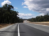
The Great Eastern Highway is a major road between the Western Australia
n cities of Perth
and Kalgoorlie
. It is a key route for vehicles accessing the eastern wheatbelt and the eastern goldfields
. It also forms the westernmost 595 kilometres (370 mi) of the main road transportation link between Perth and the east coast of Australia.
The road is mostly a federally funded national highway
due to its national strategic importance. It is signed as National Highway 94 except for a 9 km stretch between the Great Eastern Highway Bypass
and Roe Highway
, and the 40 km section between Coolgardie
and Kalgoorlie
. It is also signed as Highway 1
between The Causeway
and Morrison Road
, and State Route 51 between Johnson Street, Guildford
, and Roe Highway
.
The highway mostly runs in parallel with the Mundaring
to Kalgoorlie water pipeline
, which pipes drinking water drawn from Mundaring Weir near Perth 600 km east to Kalgoorlie. The highway was sealed by 1954. Two highways spur off Great Eastern Highway at various stages; at Perth's eastern metropolitan boundary the Great Southern Highway
begins, which links Perth to such towns as York
, Brookton
, Narrogin
, and Katanning
, and 40km prior to arrival at Kalgoorlie the Coolgardie-Esperance Highway
begins, which serves, among others Norseman
, Esperance
, and the east of Australia.
 At Greenmount Hill, the highway rises from the Swan Coastal Plain
to the Darling Scarp
at Greenmount
. The road is a key heavy vehicle route into and out of Perth, and trucks are required to descend the hill at low speed in low gear. Larger trucks are required to stop at the top of the hill and perform a brake check. Extensive signage has been placed on the down-hill side of the hill to alert truck drivers to their obligations.
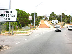
A multiple fatal accident in late 1993 at the intersection with Roe Highway
occurred where a truck lost control coming down hill and failed to stop. This accident led to the construction of a "truck arrester bed" near the bottom of the hill. It has been used in emergencies several times since.
In the 1960s, a railway level crossing in Bellevue
which had been the scene of many accidents was replaced by a bridge which passes over the main Eastern Railway line.
For a part of the Greenmount Hill route, the Old York Road - named because it had been the York Road
route in the nineteenth century - runs parallel but at much steeper grades compared to the highway, and rejoins the highway a hundred metres east of Chippers Leap
at the top of the main climb of the hill.
through to Sawyers Valley has a rising and falling route with a reduced speed limit from previous years. The reason is that numerous side roads have lower speed limits, and the difference between the highway speed and side road speed was too great in the eyes of transport managers.
The localities of Mahogany Creek and Mundaring are dissected by the highway, and a set of traffic lights at Mundaring have been erected.
and The Lakes
has been re-aligned and upgraded. The rebuilt section between has deep cuttings and is a dual carriageway, the large borrow pits along the rebuilt section being well away from the highway, but very obvious when viewed from the air.
The Highway then heads in a northerly direction with the dual carriageway being reduced to one lane with a speed limit of 110km/h applied nearly all the way except for sections near El Caballo resort, Bakers Hill, The new Clackline Bypass and other towns enroute to Kalgoorlie. The Northam Bypass was built to remove trucks from central Northam and cut travel time by 5-10 minutes by linking a new section with the old sections where Mitchell Avenue and Yilgarn Avenue meets the Highway.
A bushfire on 30 December 2007 in the Boorabbin National Park
between Southern Cross
and Coolgardie
, which cut off the highway, is now the subject of a coronial inquiry. Three truck drivers died following the Department of Environment and Conservation's decision to open the road at the eastern end.
 Towns and settlements along the way to Kalgoorlie-Boulder include Northam
, Meckering
, Cunderdin
, Tammin
, Kellerberrin
, Doodlakine
, Merredin
, Burracoppin
, Bodallin
, Moorine Rock
, Southern Cross
, Yellowdine
, Boorabbin, Bullabulling
and Coolgardie
.
The Perth section of the highway discussed in this section runs from The Causeway
interchange in Victoria Park
to the intersection with Horace Street/Farrall Road in Midvale
. The highway then runs through the outer, less urbanised suburbs of Perth, and leaves urban Perth after passing through Mundaring
, 35 kilometres (22 mi) north east of the Perth CBD by road. It does not technically leave Perth until shortly after reaching the Great Southern Highway junction, 48 kilometres (30 mi) north east of the Perth CBD by road.

 :
:
Signed as:
The highway then crosses the Helena River
and becomes Johnson Street before making a right turn into  James Street in Guildford
.
James Street/East Street:
Signed as  Great Eastern Highway:
Signed as:
terminates; signed as
Signed as
Western Australia
Western Australia is a state of Australia, occupying the entire western third of the Australian continent. It is bounded by the Indian Ocean to the north and west, the Great Australian Bight and Indian Ocean to the south, the Northern Territory to the north-east and South Australia to the south-east...
n cities of Perth
Perth, Western Australia
Perth is the capital and largest city of the Australian state of Western Australia and the fourth most populous city in Australia. The Perth metropolitan area has an estimated population of almost 1,700,000....
and Kalgoorlie
Kalgoorlie, Western Australia
Kalgoorlie, known as Kalgoorlie-Boulder, is a town in the Goldfields-Esperance region of Western Australia, and is located east-northeast of state capital Perth at the end of the Great Eastern Highway...
. It is a key route for vehicles accessing the eastern wheatbelt and the eastern goldfields
Goldfields-Esperance region of Western Australia
The Goldfields-Esperance region is one of the nine regions of Western Australia. It is located in the south eastern corner of Western Australia, and comprises the local government areas of Coolgardie, Dundas, Esperance, Kalgoorlie-Boulder, Laverton, Leonora, Menzies, Ngaanyatjarraku and...
. It also forms the westernmost 595 kilometres (370 mi) of the main road transportation link between Perth and the east coast of Australia.
The road is mostly a federally funded national highway
National Highway (Australia)
thumb|right|150px|The National Highway Shield in NSW, QLD, WA, NT & TAS.The National Highway is a system of roads connecting all the States and Territories of Australia, and is the major network of highways connecting Australia's largest and most important cities.The National Highway was...
due to its national strategic importance. It is signed as National Highway 94 except for a 9 km stretch between the Great Eastern Highway Bypass
Great Eastern Highway Bypass
Great Eastern Highway Bypass is a limited-access dual carriageway linking Great Eastern Highway and Roe Highway in Perth, Western Australia.It was opened on 14 May 1988....
and Roe Highway
Roe Highway
Roe Highway is a limited access dual carriageway in Western Australia. It links Great Northern Highway and Middle Swan Road with Kwinana Freeway. It is one of the key heavy vehicle routes in the Perth metropolitan area. Aside from intersections, the speed limit is 100 km/h for most of its length...
, and the 40 km section between Coolgardie
Coolgardie, Western Australia
Coolgardie is a small town in the Australian state of Western Australia, east of the state capital, Perth. It has a population of approximately 800 people....
and Kalgoorlie
Kalgoorlie, Western Australia
Kalgoorlie, known as Kalgoorlie-Boulder, is a town in the Goldfields-Esperance region of Western Australia, and is located east-northeast of state capital Perth at the end of the Great Eastern Highway...
. It is also signed as Highway 1
Highway 1 (Australia)
Australia's Highway 1 is a network of highways that circumnavigate the Australian continent, joining all mainland state capitals. At a total length of approximately it is the longest national highway in the world, longer than the Trans-Siberian Highway and the Trans-Canada Highway...
between The Causeway
The Causeway
The Causeway is the name of the traffic crossing of the Swan River in Western Australia at the eastern end of Perth Water. Made up of two bridges on either side of Heirisson Island, the crossing links the City of Perth and Victoria Park....
and Morrison Road
Morrison Road
Morrison Road is a major road which runs through the suburbs of Woodbridge, Midland, Midvale and Swan View, in the east of Perth, Western Australia....
, and State Route 51 between Johnson Street, Guildford
Guildford, Western Australia
Guildford is a suburb of Perth, Western Australia, located 13 km northeast of the city. Its Local Government Area is the City of Swan.-History:Guildford was established in 1829 on the Swan River, being sited near a permanent fresh water supply...
, and Roe Highway
Roe Highway
Roe Highway is a limited access dual carriageway in Western Australia. It links Great Northern Highway and Middle Swan Road with Kwinana Freeway. It is one of the key heavy vehicle routes in the Perth metropolitan area. Aside from intersections, the speed limit is 100 km/h for most of its length...
.
The highway mostly runs in parallel with the Mundaring
Mundaring, Western Australia
Mundaring is a suburb located 34 km east of Perth on the Great Eastern Highway. The suburb is located within the Shire of Mundaring.The Aboriginal name of the area 'Mindah-lung', said to mean 'a high place on a high place', was anglicised to become 'Mundaring'.The Mundaring area is also considered...
to Kalgoorlie water pipeline
Goldfields Water Supply Scheme
The Goldfields Water Supply Scheme is a pipeline and dam project which delivers potable water to communities in Western Australia's Eastern Goldfields, particularly Coolgardie and Kalgoorlie...
, which pipes drinking water drawn from Mundaring Weir near Perth 600 km east to Kalgoorlie. The highway was sealed by 1954. Two highways spur off Great Eastern Highway at various stages; at Perth's eastern metropolitan boundary the Great Southern Highway
Great Southern Highway
Great Southern Highway is a highway in the Southern Wheatbelt region of Western Australia, starting from Great Eastern Highway at The Lakes, 50 km from Perth, and ending at Albany Highway near Cranbrook. It is the primary thoroughfare for this part of Western Australia and runs parallel with the...
begins, which links Perth to such towns as York
York, Western Australia
York is the oldest inland town in Western Australia, situated 97 km east of Perth in the Avon Valley near Northam, and is the seat of the Shire of York...
, Brookton
Brookton, Western Australia
Brookton is a town located in the Wheatbelt region of Western Australia, Australia, from the state capital, Perth via the Brookton Highway where it crosses the Great Southern Highway. The town is also located on the Great Southern railway line. It is located within, and is the seat of government...
, Narrogin
Narrogin, Western Australia
Narrogin is a large town in the Wheatbelt region of Western Australia, southeast of Perth on the Great Southern Highway between Pingelly and Wagin...
, and Katanning
Katanning, Western Australia
Katanning is a town located 277 km south east of Perth, Western Australia on the Great Southern Highway. At the 2006 census, Katanning had a population of 3,808.-History:...
, and 40km prior to arrival at Kalgoorlie the Coolgardie-Esperance Highway
Coolgardie-Esperance Highway
The Coolgardie–Esperance Highway is a 368 km Western Australian highway between Coolgardie and Esperance. It runs in a north-south direction linking the WA's Eastern Goldfields to the coast....
begins, which serves, among others Norseman
Norseman, Western Australia
Norseman is a town located in the Goldfields-Esperance region of Western Australia along the Coolgardie-Esperance Highway, east of Perth and above sea level. It is also the starting point of the Eyre Highway, and the last major town in Western Australia before the South Australian border to the...
, Esperance
Esperance, Western Australia
Esperance is a large town in the Goldfields-Esperance region of Western Australia, located on the Southern Ocean coastline approximately east-southeast of the state capital, Perth. The shire of Esperance is home to 9,536 people as of the 2006 census, its major industries are tourism, agriculture,...
, and the east of Australia.
Greenmount Hill
Great Eastern Highway is notorious for Greenmount Hill, which is a relatively steep 3 km long hill on Perth's eastern outskirts.Swan Coastal Plain
The Swan Coastal Plain in Western Australia is the geographic feature which contains the Swan River as it travels west to the Indian Ocean. The coastal plain continues well beyond the boundaries of the Swan River and its tributaries, as a geological and biological zone, one of Western Australia's...
to the Darling Scarp
Darling Scarp
The Darling Scarp, also referred to as the Darling Range or Darling Ranges, is a low escarpment running north-south to the east of the Swan Coastal Plain and Perth, Western Australia...
at Greenmount
Greenmount, Western Australia
Greenmount is a locality and a geographical feature in the Shire of Mundaring, Western Australia, on the edge of the Darling Scarp. It is a vital point in the transport routes from the Swan Coastal Plain into the hinterland of Western Australia....
. The road is a key heavy vehicle route into and out of Perth, and trucks are required to descend the hill at low speed in low gear. Larger trucks are required to stop at the top of the hill and perform a brake check. Extensive signage has been placed on the down-hill side of the hill to alert truck drivers to their obligations.
A multiple fatal accident in late 1993 at the intersection with Roe Highway
Roe Highway
Roe Highway is a limited access dual carriageway in Western Australia. It links Great Northern Highway and Middle Swan Road with Kwinana Freeway. It is one of the key heavy vehicle routes in the Perth metropolitan area. Aside from intersections, the speed limit is 100 km/h for most of its length...
occurred where a truck lost control coming down hill and failed to stop. This accident led to the construction of a "truck arrester bed" near the bottom of the hill. It has been used in emergencies several times since.
In the 1960s, a railway level crossing in Bellevue
Bellevue, Western Australia
Bellevue is an eastern suburb of Perth, Western Australia. Its Local Government Areas are the City of Swan and the Shire of Mundaring, and it is located at the foot of the slopes of Greenmount, a landmark on the Darling Scarp that is noted in the earliest of travel journals of the early Swan River...
which had been the scene of many accidents was replaced by a bridge which passes over the main Eastern Railway line.
For a part of the Greenmount Hill route, the Old York Road - named because it had been the York Road
York Road, Western Australia
York Road was the main road connecting Guildford and York, in Western Australia, during the 19th and 20th centuries....
route in the nineteenth century - runs parallel but at much steeper grades compared to the highway, and rejoins the highway a hundred metres east of Chippers Leap
Chippers Leap
Chippers Leap, formerly known as Chipper's Leap, is a granite outcrop on Greenmount Hill in Perth, Western Australia. It is located at 31º54'S 116º04'E, on the northern side of Great Eastern Highway, near the border between the suburbs of Swan View and Greenmount.Chippers Leap is named for John...
at the top of the main climb of the hill.
Greenmount to Sawyers Valley
Following the sudden rise of Greenmount Hill, the route from the entrance to John Forrest National ParkJohn Forrest National Park
John Forrest National Park is a national park in the Darling Scarp, 24 km east of Perth, Western Australia. It was the first national park in Western Australia and the second in Australia after Royal National Park.- Name :...
through to Sawyers Valley has a rising and falling route with a reduced speed limit from previous years. The reason is that numerous side roads have lower speed limits, and the difference between the highway speed and side road speed was too great in the eyes of transport managers.
The localities of Mahogany Creek and Mundaring are dissected by the highway, and a set of traffic lights at Mundaring have been erected.
Sawyers Valley to The Lakes
Due to Perth's urban expansion and the growth in traffic on Great Eastern Highway, the previously two-way section of road between Sawyers ValleySawyers Valley, Western Australia
Sawyers Valley is sited on the Great Eastern Highway about 40 kilometres from Perth, Western Australia in the Shire of Mundaring.The community began as a sawmill and railway siding to process timber from the forest surrounding the Helena River to the south...
and The Lakes
The Lakes, Western Australia
The Lakes is a locality in Western Australia within the Shire of Mundaring. It is located east of the capital city of Perth at the junction of the Great Eastern Highway and the Great Southern Highway, and is the easternmost suburb within the Metropolitan Region Scheme...
has been re-aligned and upgraded. The rebuilt section between has deep cuttings and is a dual carriageway, the large borrow pits along the rebuilt section being well away from the highway, but very obvious when viewed from the air.
The Lakes to Kalgoorlie
The Highway then heads in a northerly direction with the dual carriageway being reduced to one lane with a speed limit of 110km/h applied nearly all the way except for sections near El Caballo resort, Bakers Hill, The new Clackline Bypass and other towns enroute to Kalgoorlie. The Northam Bypass was built to remove trucks from central Northam and cut travel time by 5-10 minutes by linking a new section with the old sections where Mitchell Avenue and Yilgarn Avenue meets the Highway.
A bushfire on 30 December 2007 in the Boorabbin National Park
Boorabbin National Park
Boorabbin National Park is a national park in Western Australia, between Coolgardie and Southern Cross. It is located along the Great Eastern Highway for a distance of approximately 25 km with a width of 5 km on each side in Western Australia's eastern goldfields...
between Southern Cross
Southern Cross, Western Australia
Southern Cross is a town in Western Australia, 371 kilometres east of Perth on the Great Eastern Highway. It was founded by gold prospectors in 1888, and gazetted in 1890. It is the major town and administrative centre of the Shire of Yilgarn...
and Coolgardie
Coolgardie, Western Australia
Coolgardie is a small town in the Australian state of Western Australia, east of the state capital, Perth. It has a population of approximately 800 people....
, which cut off the highway, is now the subject of a coronial inquiry. Three truck drivers died following the Department of Environment and Conservation's decision to open the road at the eastern end.
Major settlements
Northam, Western Australia
Northam is a town in Western Australia, situated at the confluence of the Avon and Mortlock Rivers, about north-east of Perth in the Avon Valley. At the 2006 census, Northam had a population of 6,009. Northam is the largest town in the Avon region...
, Meckering
Meckering, Western Australia
Meckering is a town 130 km east of Perth, Western Australia along the Great Eastern Highway. Meckering is located within the Shire of Cunderdin.A railway line was completed in the area in 1895 and Meckering was selected as a station site...
, Cunderdin
Cunderdin, Western Australia
Cunderdin is a town located in the Wheatbelt region of Western Australia 156 km east of Perth, on Great Eastern Highway.- History :The first European visitor to the area was Charles Cooke Hunt, who explored the area in 1864 and recorded the name Cunderdin, from the Aboriginal name of a nearby...
, Tammin
Tammin, Western Australia
The town of Tammin is located in the central agricultural region, east of Perth, Western Australia and midway between the towns of Cunderdin and Kellerberrin on the Great Eastern Highway.-History:...
, Kellerberrin
Kellerberrin, Western Australia
Kellerberrin is a town in the Wheatbelt region of Western Australia, east of Perth on the Great Eastern Highway.The railway line from Northam to Southern Cross was constructed through here in 1893-94, and this section opened for traffic in 1895. Kellerberrin was one of the original stations when...
, Doodlakine
Doodlakine, Western Australia
Doodlakine is located 220 km ENE of Perth, Western Australia. It is situated within the Shire of Kellerberrin along the Great Eastern Highway. The town also contains a crossing loop for trains on the Perth to Kalgoorlie railway, and serves as a stop on the Avonlink rural train service.The area...
, Merredin
Merredin, Western Australia
-Economy:The agricultural land around Merredin produces 40% of Western Australia’s wheat quota. As a focal point for the region, Merredin’s local bulk handling co-operative receives and processes in excess of a million tonnes of grain every year...
, Burracoppin
Burracoppin, Western Australia
Burracoppin is a townsite on the Great Eastern Highway, east of Merredin in the Wheatbelt region of Western Australia.The town was gazetted in 1891. It takes its name from Burracoppin Rock, a nearby granite rock, the name of which was first recorded in 1864 as Burancooping Rock. It was also shown...
, Bodallin
Bodallin, Western Australia
Bodallin is a town located around half way between Merredin and Southern Cross in Western Australia.The town takes its name from the railway siding of this name, established between 1894 and 1897. When gazetted in 1918 the town was spelt Boddalin...
, Moorine Rock
Moorine Rock, Western Australia
Moorine Rock is located in the eastern agricultural region of Western Australia, 347 km east of Perth and 22 km west south west of Southern Cross. It is located on the Great Eastern Highway and the railway line from Northam to Southern Cross. When the line was opened in 1895 a railway...
, Southern Cross
Southern Cross, Western Australia
Southern Cross is a town in Western Australia, 371 kilometres east of Perth on the Great Eastern Highway. It was founded by gold prospectors in 1888, and gazetted in 1890. It is the major town and administrative centre of the Shire of Yilgarn...
, Yellowdine
Yellowdine, Western Australia
Yellowdine is located 402 km east of Perth, Western Australia on the Great Eastern Highway. The townsite is in the goldfields region, situated in the Shire of Yilgarn.- History :...
, Boorabbin, Bullabulling
Bullabulling, Western Australia
Bullabulling is a small townsite located 526 km east of Perth, Western Australia on the Great Eastern Highway. The town was gazetted in 1898. Its central feature is the Rock Hotel roadhouse....
and Coolgardie
Coolgardie, Western Australia
Coolgardie is a small town in the Australian state of Western Australia, east of the state capital, Perth. It has a population of approximately 800 people....
.
Major Perth Junctions
The Perth section of Great Eastern Highway passes through high density and suburbs, and a vast majority of intersections receive little to no control apart from stop signs. Also noteworthy is the fact that many minor intersections are "one in, one out" intersections, that is, turning across traffic to enter or exit the roadway is not an option.The Perth section of the highway discussed in this section runs from The Causeway
The Causeway
The Causeway is the name of the traffic crossing of the Swan River in Western Australia at the eastern end of Perth Water. Made up of two bridges on either side of Heirisson Island, the crossing links the City of Perth and Victoria Park....
interchange in Victoria Park
Victoria Park, Western Australia
The Town of Victoria Park is a Local Government Area of Western Australia. It covers an area of 17.62 km² in metropolitan Perth, the capital of Western Australia. The Town of Victoria Park maintains 154.55 km of roads, a little over 1 km² of parks and gardens and has a...
to the intersection with Horace Street/Farrall Road in Midvale
Midvale, Western Australia
Midvale is a suburb of Perth, Western Australia, located mostly within the City of Swan, and partly within the Shire of Mundaring. Its postcode is 6056....
. The highway then runs through the outer, less urbanised suburbs of Perth, and leaves urban Perth after passing through Mundaring
Mundaring, Western Australia
Mundaring is a suburb located 34 km east of Perth on the Great Eastern Highway. The suburb is located within the Shire of Mundaring.The Aboriginal name of the area 'Mindah-lung', said to mean 'a high place on a high place', was anglicised to become 'Mundaring'.The Mundaring area is also considered...
, 35 kilometres (22 mi) north east of the Perth CBD by road. It does not technically leave Perth until shortly after reaching the Great Southern Highway junction, 48 kilometres (30 mi) north east of the Perth CBD by road.
Perth to Guildford
Signed as :

 The CausewayThe CausewayThe Causeway is the name of the traffic crossing of the Swan River in Western Australia at the eastern end of Perth Water. Made up of two bridges on either side of Heirisson Island, the crossing links the City of Perth and Victoria Park....
, Canning HighwayCanning HighwayCanning Highway is a mostly 4 lane single carriageway major arterial road in Perth, Western Australia. The speed limit is 60 km/h. It is located south of the Swan River and links Perth with Fremantle, running between The Causeway in Victoria Park and Queen Victoria Street in...
, Shepperton Road and Albany HighwayAlbany HighwayAlbany Highway is a generally northwest-southeast highway in the south of Western Australia which links the state's capital Perth with its oldest settlement, Albany. The highway is approximately in length, is designated State Route 30 and separates Western Australia's Great Southern region from...
, Victoria ParkVictoria Park, Western AustraliaThe Town of Victoria Park is a Local Government Area of Western Australia. It covers an area of 17.62 km² in metropolitan Perth, the capital of Western Australia. The Town of Victoria Park maintains 154.55 km of roads, a little over 1 km² of parks and gardens and has a...
and BurswoodBurswood, Western AustraliaBurswood is an inner southeastern suburb of Perth, Western Australia, located immediately across the Swan River from Perth's central business district via both The Causeway and Graham Farmer Freeway...- Bolton Avenue, BurswoodBurswood, Western AustraliaBurswood is an inner southeastern suburb of Perth, Western Australia, located immediately across the Swan River from Perth's central business district via both The Causeway and Graham Farmer Freeway...
 Graham Farmer FreewayGraham Farmer FreewayThe Graham Farmer Freeway is a major part of the metropolitan road infrastructure in Perth, Western Australia. It is long and links Rivervale and East Perth with West Perth, bypassing Perth's central business district...
/Orrong Road, BurswoodBurswood, Western AustraliaBurswood is an inner southeastern suburb of Perth, Western Australia, located immediately across the Swan River from Perth's central business district via both The Causeway and Graham Farmer Freeway...
, LathlainLathlain, Western AustraliaLathlain is an inner south eastern suburb of Perth, Western Australia. Its Local Government Area is the Town of Victoria Park.-History:Lathlain's development commenced in the 1890s when Peet and Co subdivided and sold lots in the "Victoria Park Station Estate" east of the railway station, with...
and RivervaleRivervale, Western AustraliaRivervale, near the Swan River in Australia, is a suburb of Perth, Western Australia and 5 km from Perth's central business district.Rivervale was known as Barndon Hill until 1884....- Kooyong Road, RivervaleRivervale, Western AustraliaRivervale, near the Swan River in Australia, is a suburb of Perth, Western Australia and 5 km from Perth's central business district.Rivervale was known as Barndon Hill until 1884....
- Belmont Avenue, RivervaleRivervale, Western AustraliaRivervale, near the Swan River in Australia, is a suburb of Perth, Western Australia and 5 km from Perth's central business district.Rivervale was known as Barndon Hill until 1884....
and BelmontBelmont, Western AustraliaThe City of Belmont is a Local Government Area in the inner eastern suburbs of the Western Australian capital city of Perth, located about east of Perth's central business district on the south bank of the Swan River...  Stoneham Street/Belgravia Street/Raconteur Drive, AscotAscot, Western AustraliaAscot is a suburb of Perth, the capital city of Western Australia, covering a narrow strip of land along the southern bank of the Swan River approximately east of Perth's central business district...
and BelmontBelmont, Western AustraliaThe City of Belmont is a Local Government Area in the inner eastern suburbs of the Western Australian capital city of Perth, located about east of Perth's central business district on the south bank of the Swan River...- Hardey Road, AscotAscot, Western AustraliaAscot is a suburb of Perth, the capital city of Western Australia, covering a narrow strip of land along the southern bank of the Swan River approximately east of Perth's central business district...
and BelmontBelmont, Western AustraliaThe City of Belmont is a Local Government Area in the inner eastern suburbs of the Western Australian capital city of Perth, located about east of Perth's central business district on the south bank of the Swan River...  Tonkin HighwayTonkin HighwayTonkin Highway, at , is a limited access dual carriageway in Perth, Western Australia, connecting Reid Highway in the north with Thomas Road in the south. Mostly a 4 lane highway, some sections of the highway are to a 4 to 6 lane freeway standard; the remainder of the highway has been designed to...
, AscotAscot, Western AustraliaAscot is a suburb of Perth, the capital city of Western Australia, covering a narrow strip of land along the southern bank of the Swan River approximately east of Perth's central business district...
and RedcliffeRedcliffe, Western AustraliaRedcliffe is a suburb of Perth and is located within the City of Belmont local government area.The story of its name is ambiguous: while some claim it was named after steep red clay deposits that lined the banks of the Swan River when settlers first arrived, others claim that it was named after the...- Great Eastern Highway BypassGreat Eastern Highway BypassGreat Eastern Highway Bypass is a limited-access dual carriageway linking Great Eastern Highway and Roe Highway in Perth, Western Australia.It was opened on 14 May 1988....
, South GuildfordGuildford, Western AustraliaGuildford is a suburb of Perth, Western Australia, located 13 km northeast of the city. Its Local Government Area is the City of Swan.-History:Guildford was established in 1829 on the Swan River, being sited near a permanent fresh water supply...
Signed as
:
- Kalamunda Road, South GuildfordSouth Guildford, Western AustraliaSouth Guildford is a suburb of Perth, Western Australia, located in the City of Swan local government area....
The highway then crosses the Helena River
Helena River
The Helena River is a tributary of the Swan River in Western Australia. The river rises in country east of Mount Dale and moves to the north west to Mundaring Weir, where it is dammed...
and becomes Johnson Street before making a right turn into
James Street in GuildfordGuildford, Western Australia
Guildford is a suburb of Perth, Western Australia, located 13 km northeast of the city. Its Local Government Area is the City of Swan.-History:Guildford was established in 1829 on the Swan River, being sited near a permanent fresh water supply...
.
Guildford to Midland
Signed as James Street/East Street:
-
 Meadow Street, GuildfordGuildford, Western AustraliaGuildford is a suburb of Perth, Western Australia, located 13 km northeast of the city. Its Local Government Area is the City of Swan.-History:Guildford was established in 1829 on the Swan River, being sited near a permanent fresh water supply...
 - Terrace Road, GuildfordGuildford, Western AustraliaGuildford is a suburb of Perth, Western Australia, located 13 km northeast of the city. Its Local Government Area is the City of Swan.-History:Guildford was established in 1829 on the Swan River, being sited near a permanent fresh water supply...
Signed as
Great Eastern Highway:
- Morrison Road, WoodbridgeWoodbridge, Western AustraliaWoodbridge is a suburb of Perth, Western Australia, located within the City of Swan. Woodbridge was formerly part of Midland and was previously named West Midland...
and MidlandMidland, Western AustraliaMidland is a suburb in the Perth, Western Australia metropolitan area, as well as the regional centre for the City of Swan local government area that covers the Swan Valley and parts of the Darling Scarp to the east. It is situated at the intersection of Great Eastern Highway and Great Northern...
Signed as
:- Old Great Northern HighwayGreat Northern HighwayThe Great Northern Highway is a generally north-south Western Australian highway which links the state's capital Perth with its most northern port, Wyndham. It is in length, with being National Highway...
, MidlandMidland, Western AustraliaMidland is a suburb in the Perth, Western Australia metropolitan area, as well as the regional centre for the City of Swan local government area that covers the Swan Valley and parts of the Darling Scarp to the east. It is situated at the intersection of Great Eastern Highway and Great Northern... - Helena Street, MidlandMidland, Western AustraliaMidland is a suburb in the Perth, Western Australia metropolitan area, as well as the regional centre for the City of Swan local government area that covers the Swan Valley and parts of the Darling Scarp to the east. It is situated at the intersection of Great Eastern Highway and Great Northern...
East from Midland
- Lloyd Street, MidlandMidland, Western AustraliaMidland is a suburb in the Perth, Western Australia metropolitan area, as well as the regional centre for the City of Swan local government area that covers the Swan Valley and parts of the Darling Scarp to the east. It is situated at the intersection of Great Eastern Highway and Great Northern...

 ← → Roe HighwayRoe HighwayRoe Highway is a limited access dual carriageway in Western Australia. It links Great Northern Highway and Middle Swan Road with Kwinana Freeway. It is one of the key heavy vehicle routes in the Perth metropolitan area. Aside from intersections, the speed limit is 100 km/h for most of its length...
, MidvaleMidvale, Western AustraliaMidvale is a suburb of Perth, Western Australia, located mostly within the City of Swan, and partly within the Shire of Mundaring. Its postcode is 6056....
terminates; signed as
- Horace Street/Farrall Road, MidvaleMidvale, Western AustraliaMidvale is a suburb of Perth, Western Australia, located mostly within the City of Swan, and partly within the Shire of Mundaring. Its postcode is 6056....
- Scott Street, GreenmountGreenmount, Western AustraliaGreenmount is a locality and a geographical feature in the Shire of Mundaring, Western Australia, on the edge of the Darling Scarp. It is a vital point in the transport routes from the Swan Coastal Plain into the hinterland of Western Australia....
- Darlington Road, DarlingtonDarlington, Western AustraliaDarlington, Western Australia, is a locality in the Shire of Mundaring on the Darling Scarp, dissected by Nyaania Creek and north of the Helena River.- Location :...
- Stoneville Road, MundaringMundaring, Western AustraliaMundaring is a suburb located 34 km east of Perth on the Great Eastern Highway. The suburb is located within the Shire of Mundaring.The Aboriginal name of the area 'Mindah-lung', said to mean 'a high place on a high place', was anglicised to become 'Mundaring'.The Mundaring area is also considered...
- Sawyers Road, Sawyers ValleySawyers Valley, Western AustraliaSawyers Valley is sited on the Great Eastern Highway about 40 kilometres from Perth, Western Australia in the Shire of Mundaring.The community began as a sawmill and railway siding to process timber from the forest surrounding the Helena River to the south...
- Old Northam RoadOld Northam RoadOld Northam Road is a road in the outer eastern suburbs of Perth, Western Australia. It terminates at Great Eastern Highway at both ends, and forms the main street of the town of Chidlow....
, Sawyers ValleySawyers Valley, Western AustraliaSawyers Valley is sited on the Great Eastern Highway about 40 kilometres from Perth, Western Australia in the Shire of Mundaring.The community began as a sawmill and railway siding to process timber from the forest surrounding the Helena River to the south... - Great Southern HighwayGreat Southern HighwayGreat Southern Highway is a highway in the Southern Wheatbelt region of Western Australia, starting from Great Eastern Highway at The Lakes, 50 km from Perth, and ending at Albany Highway near Cranbrook. It is the primary thoroughfare for this part of Western Australia and runs parallel with the...
, BeechinaBeechina, Western AustraliaBeechina is a locality in the Shire of Mundaring in Western Australia. The word "Beechina" is the Aboriginal name for a white gum valley to the northeast of the locality. It was first recorded by surveyor P. Chauncy in 1847, when he was carrying out the survey of the first road to Northam.-External...
and The LakesThe Lakes, Western AustraliaThe Lakes is a locality in Western Australia within the Shire of Mundaring. It is located east of the capital city of Perth at the junction of the Great Eastern Highway and the Great Southern Highway, and is the easternmost suburb within the Metropolitan Region Scheme... - Old Northam RoadOld Northam RoadOld Northam Road is a road in the outer eastern suburbs of Perth, Western Australia. It terminates at Great Eastern Highway at both ends, and forms the main street of the town of Chidlow....
/Government Road, WoorolooWooroloo, Western AustraliaWooroloo is a town on the outer fringe of the Perth metropolitan area, located off Great Eastern Highway in the eastern part of the Shire of Mundaring. At the 2006 census, Wooroloo had a population of 254.-History:... - Mitchell Avenue, NorthamNortham, Western AustraliaNortham is a town in Western Australia, situated at the confluence of the Avon and Mortlock Rivers, about north-east of Perth in the Avon Valley. At the 2006 census, Northam had a population of 6,009. Northam is the largest town in the Avon region...
 Northam - Toodyay Road, NorthamNortham, Western AustraliaNortham is a town in Western Australia, situated at the confluence of the Avon and Mortlock Rivers, about north-east of Perth in the Avon Valley. At the 2006 census, Northam had a population of 6,009. Northam is the largest town in the Avon region...
 Northam - Pithara Road, NorthamNortham, Western AustraliaNortham is a town in Western Australia, situated at the confluence of the Avon and Mortlock Rivers, about north-east of Perth in the Avon Valley. At the 2006 census, Northam had a population of 6,009. Northam is the largest town in the Avon region...
- Yilgarn Avenue, NorthamNortham, Western AustraliaNortham is a town in Western Australia, situated at the confluence of the Avon and Mortlock Rivers, about north-east of Perth in the Avon Valley. At the 2006 census, Northam had a population of 6,009. Northam is the largest town in the Avon region...
- Dunlop Street to Goomalling - Meckering Road and Dowerin - Meckering Road, MeckeringMeckering, Western AustraliaMeckering is a town 130 km east of Perth, Western Australia along the Great Eastern Highway. Meckering is located within the Shire of Cunderdin.A railway line was completed in the area in 1895 and Meckering was selected as a station site...
- Cunderdin - Wyalkatchem Road, CunderdinCunderdin, Western AustraliaCunderdin is a town located in the Wheatbelt region of Western Australia 156 km east of Perth, on Great Eastern Highway.- History :The first European visitor to the area was Charles Cooke Hunt, who explored the area in 1864 and recorded the name Cunderdin, from the Aboriginal name of a nearby...
- Cunderdin - Quairading Road, CunderdinCunderdin, Western AustraliaCunderdin is a town located in the Wheatbelt region of Western Australia 156 km east of Perth, on Great Eastern Highway.- History :The first European visitor to the area was Charles Cooke Hunt, who explored the area in 1864 and recorded the name Cunderdin, from the Aboriginal name of a nearby...
- Tammin - Wyalkatchem Road, TamminTammin, Western AustraliaThe town of Tammin is located in the central agricultural region, east of Perth, Western Australia and midway between the towns of Cunderdin and Kellerberrin on the Great Eastern Highway.-History:...
- West Crossing Road, KellerberrinKellerberrin, Western AustraliaKellerberrin is a town in the Wheatbelt region of Western Australia, east of Perth on the Great Eastern Highway.The railway line from Northam to Southern Cross was constructed through here in 1893-94, and this section opened for traffic in 1895. Kellerberrin was one of the original stations when...
- Kellerberrin - Yoting Road, KellerberrinKellerberrin, Western AustraliaKellerberrin is a town in the Wheatbelt region of Western Australia, east of Perth on the Great Eastern Highway.The railway line from Northam to Southern Cross was constructed through here in 1893-94, and this section opened for traffic in 1895. Kellerberrin was one of the original stations when...
- East Crossing Road, KellerberrinKellerberrin, Western AustraliaKellerberrin is a town in the Wheatbelt region of Western Australia, east of Perth on the Great Eastern Highway.The railway line from Northam to Southern Cross was constructed through here in 1893-94, and this section opened for traffic in 1895. Kellerberrin was one of the original stations when...
- Kellerberrin - Shackelton Road, KellerberrinKellerberrin, Western AustraliaKellerberrin is a town in the Wheatbelt region of Western Australia, east of Perth on the Great Eastern Highway.The railway line from Northam to Southern Cross was constructed through here in 1893-94, and this section opened for traffic in 1895. Kellerberrin was one of the original stations when...
- Merredin - Narembeen Road, MerredinMerredin, Western Australia-Economy:The agricultural land around Merredin produces 40% of Western Australia’s wheat quota. As a focal point for the region, Merredin’s local bulk handling co-operative receives and processes in excess of a million tonnes of grain every year...
- Antares Street, Southern CrossSouthern Cross, Western AustraliaSouthern Cross is a town in Western Australia, 371 kilometres east of Perth on the Great Eastern Highway. It was founded by gold prospectors in 1888, and gazetted in 1890. It is the major town and administrative centre of the Shire of Yilgarn...
- Marvel Loch Road, Southern CrossSouthern Cross, Western AustraliaSouthern Cross is a town in Western Australia, 371 kilometres east of Perth on the Great Eastern Highway. It was founded by gold prospectors in 1888, and gazetted in 1890. It is the major town and administrative centre of the Shire of Yilgarn...
- Poliars Street, Southern CrossSouthern Cross, Western AustraliaSouthern Cross is a town in Western Australia, 371 kilometres east of Perth on the Great Eastern Highway. It was founded by gold prospectors in 1888, and gazetted in 1890. It is the major town and administrative centre of the Shire of Yilgarn...
- Victoria Rock Road, CoolgardieCoolgardie, Western AustraliaCoolgardie is a small town in the Australian state of Western Australia, east of the state capital, Perth. It has a population of approximately 800 people....
- Moran Street, CoolgardieCoolgardie, Western AustraliaCoolgardie is a small town in the Australian state of Western Australia, east of the state capital, Perth. It has a population of approximately 800 people....
- Hunt Street, CoolgardieCoolgardie, Western AustraliaCoolgardie is a small town in the Australian state of Western Australia, east of the state capital, Perth. It has a population of approximately 800 people....
- → Coolgardie-Esperance HighwayCoolgardie-Esperance HighwayThe Coolgardie–Esperance Highway is a 368 km Western Australian highway between Coolgardie and Esperance. It runs in a north-south direction linking the WA's Eastern Goldfields to the coast....
, CoolgardieCoolgardie, Western AustraliaCoolgardie is a small town in the Australian state of Western Australia, east of the state capital, Perth. It has a population of approximately 800 people....
Signed as
- Anzac Drive, KalgoorlieKalgoorlie, Western AustraliaKalgoorlie, known as Kalgoorlie-Boulder, is a town in the Goldfields-Esperance region of Western Australia, and is located east-northeast of state capital Perth at the end of the Great Eastern Highway...
- Gatacre Drive, KalgoorlieKalgoorlie, Western AustraliaKalgoorlie, known as Kalgoorlie-Boulder, is a town in the Goldfields-Esperance region of Western Australia, and is located east-northeast of state capital Perth at the end of the Great Eastern Highway...
- Boulder Street, KalgoorlieKalgoorlie, Western AustraliaKalgoorlie, known as Kalgoorlie-Boulder, is a town in the Goldfields-Esperance region of Western Australia, and is located east-northeast of state capital Perth at the end of the Great Eastern Highway...
- → Goldfields HighwayGoldfields HighwayGoldfields Highway is a generally northwest-southeast highway in central Western Australia which links the Great Northern Highway at Meekatharra with Coolgardie-Esperance Highway south of Kalgoorlie...
, KalgoorlieKalgoorlie, Western AustraliaKalgoorlie, known as Kalgoorlie-Boulder, is a town in the Goldfields-Esperance region of Western Australia, and is located east-northeast of state capital Perth at the end of the Great Eastern Highway...