
Calder Highway
Encyclopedia
Victoria (Australia)
Victoria is the second most populous state in Australia. Geographically the smallest mainland state, Victoria is bordered by New South Wales, South Australia, and Tasmania on Boundary Islet to the north, west and south respectively....
, to Mildura
Mildura, Victoria
Mildura is a regional city in northwestern Victoria, Australia and seat of the Rural City of Mildura local government area. It is located in the Sunraysia region, and is on the banks of the Murray River. The current population is estimated at just over 30,000.Mildura is a major agricultural centre...
. North of the Victoria/New South Wales border, the highway continues north to Broken Hill
Broken Hill, New South Wales
-Geology:Broken Hill's massive orebody, which formed about 1,800 million years ago, has proved to be among the world's largest silver-lead-zinc mineral deposits. The orebody is shaped like a boomerang plunging into the earth at its ends and outcropping in the centre. The protruding tip of the...
, Tibooburra
Tibooburra, New South Wales
Tibooburra has an arid, desert climate with temperatures soaring above 40°Celsius in summer, often reaching as high as 47°C . Temperatures are milder in winter, averaging around 20°C in the daytime. These extreme temperatures make Tibooburra the hottest town in New South Wales, as reported on...
and the New South Wales/Queensland border as the Silver City Highway
Silver City Highway
The Silver City Highway is a highway in the state of New South Wales, Australia. It runs from south to north close to the western border of New South Wales with South Australia...
, under the standard

History
The Calder Highway was named after William Calder, who was chairman of the Victorian road construction authority formerly known as the Country Roads Board from 1913 to 1928. The CRB is today known as VicRoadsVicRoads
VicRoads or the Roads Corporation of Victoria is a statutory corporation which is the state road and traffic authority in the state of Victoria, Australia. It is responsible for maintenance and construction of the state arterial road network, as well as driver licensing and vehicle registration. ...
.
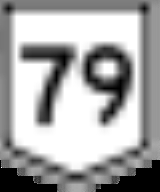
The highway was originally allocated a National Route 79 shield. With Victoria's conversion to the newer alphanumeric system in the late 1990s this was altered to a
 designation for the majority highway portion.
Route
South of the Victoria/New South Wales border the highway is a two-lane, single carriageway in each direction, continuing through northwest Victoria from the Abbotsford BridgeMurray River crossings
The Murray River in south-eastern Australia has been a significant barrier to land-based travel and trade. This article lists and briefly describes all of the recognised crossing points. Many of these had also developed as river ports for transport of goods along the Murray...
, through Merbein
Merbein, Victoria
Merbein is a town outside Mildura, Victoria, in the Sunraysia region of Australia. At the 2006 census, Merbein had a population of 2526.The area was known as White Cliffs until 1909 when the township was established, the Post Office opening on 16 August 1909.The name was intended to be Merebin,...
to the major regional town of Mildura
Mildura, Victoria
Mildura is a regional city in northwestern Victoria, Australia and seat of the Rural City of Mildura local government area. It is located in the Sunraysia region, and is on the banks of the Murray River. The current population is estimated at just over 30,000.Mildura is a major agricultural centre...
in the state's north-west. Here also it crosses the Sturt Highway
Sturt Highway
The Sturt Highway is an Australian highway in New South Wales, Victoria, and South Australia. It is part of the Auslink National network and is part of the main highway route between Sydney and Adelaide.-Route:...
 , leading to capital cities Adelaide heading west and Sydney heading east. Further south, it crosses the Mallee Highway
Mallee Highway
The Mallee Highway runs east from Tailem Bend in South Australia through cereal-growing farmland at the southern end of the Murray Mallee to Pinnaroo near the border with Victoria, where it crosses route...

Ouyen, Victoria
Ouyen is a town in Victoria, Australia, located in the Rural City of Mildura at the junction of the Calder Highway and Mallee Highway, south of Mildura and north-west of Melbourne. At the 2006 census the town had a population of 1,061.-History:...
and runs south-east eventually to Bendigo
Bendigo, Victoria
Bendigo is a major regional city in the state of Victoria, Australia, located very close to the geographical centre of the state and approximately north west of the state capital Melbourne. It is the second largest inland city and fourth most populous city in the state. The estimated urban...
. Between Wycheproof and Red Cliffs
Red Cliffs, Victoria
Red Cliffs is a town in Victoria, Australia in the Sunraysia region. It is located on the Calder Highway, 16 km south of Mildura and 544 km north-west of Melbourne....
the highway has a speed limit of 110 km/h.
The Calder Alternate Highway, leaves the
just north of Ravenswood and bypasses the Bendigo suburban area, rejoining the at Marong, west of Bendigo.For most of its length from Bendigo to its end at its junction with the Tullamarine Freeway
Tullamarine Freeway
The Tullamarine Freeway is an urban freeway in Melbourne, Australia, linking Melbourne Airport to the central business district.-History:Tullamarine Freeway is one of the oldest freeways in Melbourne, originally constructed in 1968-1970...
in Melbourne, the Calder Highway is a four lane dual carriageway, upgraded to freeway standard as the Calder Freeway
Calder Freeway
Calder Freeway is a freeway linking Melbourne to Ravenswood South in Victoria, Australia, superseding stretches of the Calder Highway. Originally just a short spur of the Tullamarine Freeway linking to the Calder Highway in Keilor in suburban Melbourne, it has been extended in phases to Ravenswood...
. The Old Calder Highway has been designated
 from where it leaves the new Calder Freeway at Ravenswood South.
Major intersections and towns
| Calder Highway |
|||
| Northbound | Distance to Broken Hill (km) |
Distance to Melbourne (km) |
Southbound |
| End Calder Highway continues as Silver City Highway Silver City Highway The Silver City Highway is a highway in the state of New South Wales, Australia. It runs from south to north close to the western border of New South Wales with South Australia... to Wentworth Wentworth, New South Wales Wentworth is a small border town in the far south west of the state of New South Wales, Australia. It lies at the confluence of Australia's two most important rivers, the Darling and the Murray, the latter forming the border with the state of Victoria to the south. The border with the state of... / Broken Hill Broken Hill, New South Wales -Geology:Broken Hill's massive orebody, which formed about 1,800 million years ago, has proved to be among the world's largest silver-lead-zinc mineral deposits. The orebody is shaped like a boomerang plunging into the earth at its ends and outcropping in the centre. The protruding tip of the... |
273 | 565 | Start Calder Highway from Silver City Highway Silver City Highway The Silver City Highway is a highway in the state of New South Wales, Australia. It runs from south to north close to the western border of New South Wales with South Australia... |
| Buronga Buronga, New South Wales Buronga is a town in New South Wales, Australia on the Murray River. The George Chaffey Bridge connects Buronga with Mildura, Victoria. In 2006, the town had a population of 807 people.-Buronga Today:... Silver City Highway Silver City Highway The Silver City Highway is a highway in the state of New South Wales, Australia. It runs from south to north close to the western border of New South Wales with South Australia... .svg.png) |
|||
| Start |
273.5 | 564.5 | End |
| MURRAY RIVER Murray River The Murray River is Australia's longest river. At in length, the Murray rises in the Australian Alps, draining the western side of Australia's highest mountains and, for most of its length, meanders across Australia's inland plains, forming the border between New South Wales and Victoria as it... |
MURRAY RIVER Murray River The Murray River is Australia's longest river. At in length, the Murray rises in the Australian Alps, draining the western side of Australia's highest mountains and, for most of its length, meanders across Australia's inland plains, forming the border between New South Wales and Victoria as it... |
||
| NEW SOUTH WALES STATE BORDER VICTORIA |
|||
| End |
273.5 | 564.5 | Start |
| Mildura Town Centre Mildura, Victoria Mildura is a regional city in northwestern Victoria, Australia and seat of the Rural City of Mildura local government area. It is located in the Sunraysia region, and is on the banks of the Murray River. The current population is estimated at just over 30,000.Mildura is a major agricultural centre... Ranfurly Way |
284.5 | 553.5 | Merbein Merbein, Victoria Merbein is a town outside Mildura, Victoria, in the Sunraysia region of Australia. At the 2006 census, Merbein had a population of 2526.The area was known as White Cliffs until 1909 when the township was established, the Post Office opening on 16 August 1909.The name was intended to be Merebin,... |
| Merbein Merbein, Victoria Merbein is a town outside Mildura, Victoria, in the Sunraysia region of Australia. At the 2006 census, Merbein had a population of 2526.The area was known as White Cliffs until 1909 when the township was established, the Post Office opening on 16 August 1909.The name was intended to be Merebin,... |
Mildura Town Centre Mildura, Victoria Mildura is a regional city in northwestern Victoria, Australia and seat of the Rural City of Mildura local government area. It is located in the Sunraysia region, and is on the banks of the Murray River. The current population is estimated at just over 30,000.Mildura is a major agricultural centre... Ranfurly Way |
||
MILDURA RAIL LINE .svg.png) |
285 | 553 | MILDURA RAIL LINE |
| continues as |
294 | 544 | Renmark Renmark, South Australia Renmark is a town in South Australia's rural Riverland area, and is located 254 km northeast of Adelaide, on the banks of the River Murray. The Sturt Highway between Adelaide and Sydney runs through the town; Renmark is the last major town encountered in South Australia when driving this route. It... , Adelaide Adelaide Adelaide is the capital city of South Australia and the fifth-largest city in Australia. Adelaide has an estimated population of more than 1.2 million... Sturt Highway Sturt Highway The Sturt Highway is an Australian highway in New South Wales, Victoria, and South Australia. It is part of the Auslink National network and is part of the main highway route between Sydney and Adelaide.-Route:... |
| Renmark Renmark, South Australia Renmark is a town in South Australia's rural Riverland area, and is located 254 km northeast of Adelaide, on the banks of the River Murray. The Sturt Highway between Adelaide and Sydney runs through the town; Renmark is the last major town encountered in South Australia when driving this route. It... , Adelaide Adelaide Adelaide is the capital city of South Australia and the fifth-largest city in Australia. Adelaide has an estimated population of more than 1.2 million... Sturt Highway Sturt Highway The Sturt Highway is an Australian highway in New South Wales, Victoria, and South Australia. It is part of the Auslink National network and is part of the main highway route between Sydney and Adelaide.-Route:... |
duplexes with |
||
| Northbound | Distance to Mildura (km) |
Distance to Melbourne via (km) |
Southbound |
| duplexes with |
2 | 541 | Mildura Town Centre Mildura, Victoria Mildura is a regional city in northwestern Victoria, Australia and seat of the Rural City of Mildura local government area. It is located in the Sunraysia region, and is on the banks of the Murray River. The current population is estimated at just over 30,000.Mildura is a major agricultural centre... , Balranald Balranald, New South Wales Balranald is a town and local government area in the Riverina district of New South Wales, Australia. At the 2006 census the population was 1,216.... , Sydney Sydney Sydney is the most populous city in Australia and the state capital of New South Wales. Sydney is located on Australia's south-east coast of the Tasman Sea. As of June 2010, the greater metropolitan area had an approximate population of 4.6 million people... Sturt Highway Sturt Highway The Sturt Highway is an Australian highway in New South Wales, Victoria, and South Australia. It is part of the Auslink National network and is part of the main highway route between Sydney and Adelaide.-Route:... .svg.png) |
| Mildura Town Centre Mildura, Victoria Mildura is a regional city in northwestern Victoria, Australia and seat of the Rural City of Mildura local government area. It is located in the Sunraysia region, and is on the banks of the Murray River. The current population is estimated at just over 30,000.Mildura is a major agricultural centre... , Balranald Balranald, New South Wales Balranald is a town and local government area in the Riverina district of New South Wales, Australia. At the 2006 census the population was 1,216.... , Sydney Sydney Sydney is the most populous city in Australia and the state capital of New South Wales. Sydney is located on Australia's south-east coast of the Tasman Sea. As of June 2010, the greater metropolitan area had an approximate population of 4.6 million people... Sturt Highway Sturt Highway The Sturt Highway is an Australian highway in New South Wales, Victoria, and South Australia. It is part of the Auslink National network and is part of the main highway route between Sydney and Adelaide.-Route:... |
continues as |
||
| Buronga Buronga, New South Wales Buronga is a town in New South Wales, Australia on the Murray River. The George Chaffey Bridge connects Buronga with Mildura, Victoria. In 2006, the town had a population of 807 people.-Buronga Today:... Benetook Avenue (Buronga-Mildura Road) |
4 | 539 | Buronga Buronga, New South Wales Buronga is a town in New South Wales, Australia on the Murray River. The George Chaffey Bridge connects Buronga with Mildura, Victoria. In 2006, the town had a population of 807 people.-Buronga Today:... Benetook Avenue (Buronga-Mildura Road) |
| MILDURA RAIL LINE |
6 | 537 | Irymple Irymple, Victoria Irymple is a town in the state of Victoria in Australia. Located in the region of Sunraysia in the far North-West Victoria, Irymple is 6 km south of Mildura and 550 km northwest of Melbourne... |
| Irymple Irymple, Victoria Irymple is a town in the state of Victoria in Australia. Located in the region of Sunraysia in the far North-West Victoria, Irymple is 6 km south of Mildura and 550 km northwest of Melbourne... |
MILDURA RAIL LINE |
||
| Red Cliffs Red Cliffs, Victoria Red Cliffs is a town in Victoria, Australia in the Sunraysia region. It is located on the Calder Highway, 16 km south of Mildura and 544 km north-west of Melbourne.... |
15 | 528 | Red Cliffs Red Cliffs, Victoria Red Cliffs is a town in Victoria, Australia in the Sunraysia region. It is located on the Calder Highway, 16 km south of Mildura and 544 km north-west of Melbourne.... |
| Meringur Meringur, Victoria Meringur is a farming settlement to the west of Mildura in northwestern Victoria, Australia. At the 2006 census, Meringur and the surrounding area had a population of 147... Red Cliffs-Meringur Road |
17 | 526 | Meringur Meringur, Victoria Meringur is a farming settlement to the west of Mildura in northwestern Victoria, Australia. At the 2006 census, Meringur and the surrounding area had a population of 147... Red Cliffs-Meringur Road |
| Colignan Colignan, Victoria Colignan is a small rural town located on the banks of the Murray River, in North Western Victoria, Australia. The town is on the border of the Hattah-Kulkyne National Park... Red Cliffs-Colignan Road |
18 | 525 | Colignan Colignan, Victoria Colignan is a small rural town located on the banks of the Murray River, in North Western Victoria, Australia. The town is on the border of the Hattah-Kulkyne National Park... Red Cliffs-Colignan Road |
| Robinvale Robinvale, Victoria Robinvale is a town on the south bank of the Murray River in northern Victoria, Australia. It is connected by a bridge to Euston on the other side of the river in New South Wales. At the 2006 census, Robinvale had a population of 2214.-History:... Hattah-Robinvale Road |
67 | 476 | Robinvale Robinvale, Victoria Robinvale is a town on the south bank of the Murray River in northern Victoria, Australia. It is connected by a bridge to Euston on the other side of the river in New South Wales. At the 2006 census, Robinvale had a population of 2214.-History:... Hattah-Robinvale Road |
| Ouyen Ouyen, Victoria Ouyen is a town in Victoria, Australia, located in the Rural City of Mildura at the junction of the Calder Highway and Mallee Highway, south of Mildura and north-west of Melbourne. At the 2006 census the town had a population of 1,061.-History:... |
102 | 441 | Ouyen Ouyen, Victoria Ouyen is a town in Victoria, Australia, located in the Rural City of Mildura at the junction of the Calder Highway and Mallee Highway, south of Mildura and north-west of Melbourne. At the 2006 census the town had a population of 1,061.-History:... |
| continues as |
102.2 | 440.8 | Piangil Piangil, Victoria Piangil is a remote town in Northern Victoria, Australia. It is approximately north west of Swan Hill. At the 2006 census, Piangil had a population of 654.... , Swan Hill Swan Hill, Victoria Swan Hill is a city in the northwest of Victoria, Australia. It is located on the Murray Valley Highway, on the south bank of the Murray River, downstream from the junction of the Loddon River. At the 2006 census, Swan Hill had a population of 9,684.-History:... Mallee Highway Mallee Highway The Mallee Highway runs east from Tailem Bend in South Australia through cereal-growing farmland at the southern end of the Murray Mallee to Pinnaroo near the border with Victoria, where it crosses route... |
| Piangil Piangil, Victoria Piangil is a remote town in Northern Victoria, Australia. It is approximately north west of Swan Hill. At the 2006 census, Piangil had a population of 654.... , Balranald Balranald, New South Wales Balranald is a town and local government area in the Riverina district of New South Wales, Australia. At the 2006 census the population was 1,216.... , Sydney Sydney Sydney is the most populous city in Australia and the state capital of New South Wales. Sydney is located on Australia's south-east coast of the Tasman Sea. As of June 2010, the greater metropolitan area had an approximate population of 4.6 million people... Mallee Highway Mallee Highway The Mallee Highway runs east from Tailem Bend in South Australia through cereal-growing farmland at the southern end of the Murray Mallee to Pinnaroo near the border with Victoria, where it crosses route... |
duplexes with |
||
| duplexes with |
102.3 | 440.7 | Pinnaroo Pinnaroo, South Australia Pinnaroo is a town in the Murray Mallee region of South Australia, near the border with Victoria 243 km east of Adelaide. Pinnaroo is on the Mallee Highway, and the railway line between Tailem Bend and Ouyen. The roadhouses on the highway are the first food and leg-stretch stop on the bus route... , Murray Bridge Murray Bridge, South Australia Murray Bridge is the fourth most populous city in South Australia after Adelaide, Mount Gambier and Whyalla. It is located east-southeast of Adelaide and north of Meningie.... , Adelaide Adelaide Adelaide is the capital city of South Australia and the fifth-largest city in Australia. Adelaide has an estimated population of more than 1.2 million... Mallee Highway Mallee Highway The Mallee Highway runs east from Tailem Bend in South Australia through cereal-growing farmland at the southern end of the Murray Mallee to Pinnaroo near the border with Victoria, where it crosses route... |
| Pinnaroo Pinnaroo, South Australia Pinnaroo is a town in the Murray Mallee region of South Australia, near the border with Victoria 243 km east of Adelaide. Pinnaroo is on the Mallee Highway, and the railway line between Tailem Bend and Ouyen. The roadhouses on the highway are the first food and leg-stretch stop on the bus route... , Murray Bridge Murray Bridge, South Australia Murray Bridge is the fourth most populous city in South Australia after Adelaide, Mount Gambier and Whyalla. It is located east-southeast of Adelaide and north of Meningie.... , Adelaide Adelaide Adelaide is the capital city of South Australia and the fifth-largest city in Australia. Adelaide has an estimated population of more than 1.2 million... Mallee Highway Mallee Highway The Mallee Highway runs east from Tailem Bend in South Australia through cereal-growing farmland at the southern end of the Murray Mallee to Pinnaroo near the border with Victoria, where it crosses route... |
continues as |
||
| Birchip Birchip, Victoria Birchip is a town in the Mallee region of Victoria, Australia on the Sunraysia Highway north of Donald. The town is located in the Shire of Buloke Local Government Area. At the 2006 census Birchip had a population of 822... Sunraysia Highway Sunraysia Highway The Sunraysia Highway , is a important north-south route in western Victoria. The highway extends north a length of 331 km from the Western Highway near Ballarat to the Calder Highway near Ouyen....  |
113 | 430 | Birchip Birchip, Victoria Birchip is a town in the Mallee region of Victoria, Australia on the Sunraysia Highway north of Donald. The town is located in the Shire of Buloke Local Government Area. At the 2006 census Birchip had a population of 822... , Ballarat Ballarat, Victoria Ballarat is a city in the state of Victoria, Australia, approximately west-north-west of the state capital Melbourne situated on the lower plains of the Great Dividing Range and the Yarrowee River catchment. It is the largest inland centre and third most populous city in the state and the fifth... , Portland Portland, Victoria The city of Portland is the oldest European settlement in what is now the state of Victoria, Australia. It is the main urban centre of the Shire of Glenelg. It is located on Portland Bay.-History:... , Melbourne Melbourne Melbourne is the capital and most populous city in the state of Victoria, and the second most populous city in Australia. The Melbourne City Centre is the hub of the greater metropolitan area and the Census statistical division—of which "Melbourne" is the common name. As of June 2009, the greater... via  Freeway FreewayWestern Freeway (Victoria) The Western Freeway is a 125 kilometre Australian freeway linking the state capital of Victoria to the major regional city of Ballarat... Sunraysia Highway Sunraysia Highway The Sunraysia Highway , is a important north-south route in western Victoria. The highway extends north a length of 331 km from the Western Highway near Ballarat to the Calder Highway near Ouyen.... |
| KULWIN RAIL LINE |
139 | 404 | Mittyack Mittyack, Victoria Mittyack is a locality in Victoria, Australia, located approximately 37 km from Ouyen.Located in a wheat-growing area of the Mallee the locality was settled in the 1910s, the Post Office opening on 5 December 1916 and closing in 1979.-External links:*... |
| Mittyack Mittyack, Victoria Mittyack is a locality in Victoria, Australia, located approximately 37 km from Ouyen.Located in a wheat-growing area of the Mallee the locality was settled in the 1910s, the Post Office opening on 5 December 1916 and closing in 1979.-External links:*... |
KULWIN RAIL LINE |
||
| Patchewollock Patchewollock, Victoria Patchewollock is a small town in North-West Victoria, Australia. At the 2006 census, Patchewollock and the surrounding area had a population of 322.... Patchewollock-Sea Lake Road |
172 | 371 | Patchewollock Patchewollock, Victoria Patchewollock is a small town in North-West Victoria, Australia. At the 2006 census, Patchewollock and the surrounding area had a population of 322.... Patchewollock-Sea Lake Road |
| Robinvale Robinvale, Victoria Robinvale is a town on the south bank of the Murray River in northern Victoria, Australia. It is connected by a bridge to Euston on the other side of the river in New South Wales. At the 2006 census, Robinvale had a population of 2214.-History:... Robinvale-Sea Lake Road |
187 | 356 | Robinvale Robinvale, Victoria Robinvale is a town on the south bank of the Murray River in northern Victoria, Australia. It is connected by a bridge to Euston on the other side of the river in New South Wales. At the 2006 census, Robinvale had a population of 2214.-History:... Robinvale-Sea Lake Road |
| continues as |
191 | 352 | Sea Lake Sea Lake, Victoria Sea Lake is a town in the Mallee district of north-west Victoria, Australia and is situated on the southern shores of Lake Tyrrell. The town is located on the Calder Highway, north-west of Melbourne, and west of Swan Hill. Sea Lake is in the heart of Australia's "wheat belt", and is the main... |
| Swan Hill Swan Hill, Victoria Swan Hill is a city in the northwest of Victoria, Australia. It is located on the Murray Valley Highway, on the south bank of the Murray River, downstream from the junction of the Loddon River. At the 2006 census, Swan Hill had a population of 9,684.-History:... Sea Lake-Swan Hill Road |
Swan Hill Swan Hill, Victoria Swan Hill is a city in the northwest of Victoria, Australia. It is located on the Murray Valley Highway, on the south bank of the Murray River, downstream from the junction of the Loddon River. At the 2006 census, Swan Hill had a population of 9,684.-History:... Sea Lake-Swan Hill Road |
||
| Sea Lake Sea Lake, Victoria Sea Lake is a town in the Mallee district of north-west Victoria, Australia and is situated on the southern shores of Lake Tyrrell. The town is located on the Calder Highway, north-west of Melbourne, and west of Swan Hill. Sea Lake is in the heart of Australia's "wheat belt", and is the main... |
duplexes with |
||
| duplexes with |
191.5 | 351.5 | To Birchip Birchip, Victoria Birchip is a town in the Mallee region of Victoria, Australia on the Sunraysia Highway north of Donald. The town is located in the Shire of Buloke Local Government Area. At the 2006 census Birchip had a population of 822... ; Hopetoun Hopetoun, Victoria Hopetoun is a town which serves as the major service centre for the Southern Mallee area of Victoria, Australia. Hopetoun is situated 400 kilometres north-west of Melbourne on the Henty Highway in the Shire of Yarriambiack... Birchip-Sea Lake Road |
| To Birchip Birchip, Victoria Birchip is a town in the Mallee region of Victoria, Australia on the Sunraysia Highway north of Donald. The town is located in the Shire of Buloke Local Government Area. At the 2006 census Birchip had a population of 822... ; Hopetoun Hopetoun, Victoria Hopetoun is a town which serves as the major service centre for the Southern Mallee area of Victoria, Australia. Hopetoun is situated 400 kilometres north-west of Melbourne on the Henty Highway in the Shire of Yarriambiack... Birchip-Sea Lake Road |
continues as |
||
| Donald Donald, Victoria Donald is a town in Victoria, Australia, located on the Richardson River, at the junction of Sunraysia Highway and Borung Highway, in the Shire of Buloke. The town is named after William Donald, a Scottish pastoralist who was the first settler in the area in 1844... , Swan Hill Swan Hill, Victoria Swan Hill is a city in the northwest of Victoria, Australia. It is located on the Murray Valley Highway, on the south bank of the Murray River, downstream from the junction of the Loddon River. At the 2006 census, Swan Hill had a population of 9,684.-History:... Donald-Swan Hill Road |
252 | 291 | Swan Hill Swan Hill, Victoria Swan Hill is a city in the northwest of Victoria, Australia. It is located on the Murray Valley Highway, on the south bank of the Murray River, downstream from the junction of the Loddon River. At the 2006 census, Swan Hill had a population of 9,684.-History:... , Donald Donald, Victoria Donald is a town in Victoria, Australia, located on the Richardson River, at the junction of Sunraysia Highway and Borung Highway, in the Shire of Buloke. The town is named after William Donald, a Scottish pastoralist who was the first settler in the area in 1844... Donald-Swan Hill Road |
| Birchip Birchip, Victoria Birchip is a town in the Mallee region of Victoria, Australia on the Sunraysia Highway north of Donald. The town is located in the Shire of Buloke Local Government Area. At the 2006 census Birchip had a population of 822... Birchip-Wycheproof Road |
267 | 276 | Birchip Birchip, Victoria Birchip is a town in the Mallee region of Victoria, Australia on the Sunraysia Highway north of Donald. The town is located in the Shire of Buloke Local Government Area. At the 2006 census Birchip had a population of 822... Birchip-Wycheproof Road |
| Boort Boort, Victoria Boort is a town in Victoria, Australia, located next to Lake Boort, in the Shire of Loddon. At the 2006 census, Boort had a population of 773. The town is known for its native birdlife... Boort-Wycheproof Road |
268 | 275 | Wycheproof Wycheproof, Victoria Wycheproof is a small regional locality in the centre of the Shire of Buloke, in north western Victoria, Australia. As of the 2006 census, it had a population of 686... |
| Wycheproof Wycheproof, Victoria Wycheproof is a small regional locality in the centre of the Shire of Buloke, in north western Victoria, Australia. As of the 2006 census, it had a population of 686... |
Boort Boort, Victoria Boort is a town in Victoria, Australia, located next to Lake Boort, in the Shire of Loddon. At the 2006 census, Boort had a population of 773. The town is known for its native birdlife... Boort-Wycheproof Road |
||
| KULWIN RAIL LINE |
268.5 | 274.5 | KULWIN RAIL LINE |
| St Arnaud St Arnaud-Wycheproof Road |
274 | 269 | St Arnaud St Arnaud-Wycheproof Road |
| KULWIN RAIL LINE |
288 | 255 | KULWIN RAIL LINE |
| KULWIN RAIL LINE |
297 | 246 | KULWIN RAIL LINE |
| Donald Donald, Victoria Donald is a town in Victoria, Australia, located on the Richardson River, at the junction of Sunraysia Highway and Borung Highway, in the Shire of Buloke. The town is named after William Donald, a Scottish pastoralist who was the first settler in the area in 1844... , Dimboola Dimboola, Victoria Dimboola is located in Shire of Hindmarsh in the Wimmera region of Western Victoria, Australia, 334 kilometres north-west of Melbourne.Situated on the Wimmera River in the State of Victoria,the town of Dimboola was previously known as 'Nine Creeks'.Following a survey conducted in late 1862 by... Borung Highway Borung Highway The Borung Highway is a 140 kilometre rural highway in western Victoria running in a west-east direction from Dimboola in the west to Charlton in the east...  |
Donald Donald, Victoria Donald is a town in Victoria, Australia, located on the Richardson River, at the junction of Sunraysia Highway and Borung Highway, in the Shire of Buloke. The town is named after William Donald, a Scottish pastoralist who was the first settler in the area in 1844... , Dimboola Dimboola, Victoria Dimboola is located in Shire of Hindmarsh in the Wimmera region of Western Victoria, Australia, 334 kilometres north-west of Melbourne.Situated on the Wimmera River in the State of Victoria,the town of Dimboola was previously known as 'Nine Creeks'.Following a survey conducted in late 1862 by... Borung Highway Borung Highway The Borung Highway is a 140 kilometre rural highway in western Victoria running in a west-east direction from Dimboola in the west to Charlton in the east... |
||
| St Arnaud Charlton-St Arnaud Road |
298 | 245 | Charlton Charlton, Victoria Charlton "The Friendly River Town", is a town in Victoria, Australia. It is a small agricultural community straddling the Avoca River, located at the junction of the Calder Highway and Borung Highway and positioned in the last of the foothills of the Great Dividing Range... |
| Charlton Charlton, Victoria Charlton "The Friendly River Town", is a town in Victoria, Australia. It is a small agricultural community straddling the Avoca River, located at the junction of the Calder Highway and Borung Highway and positioned in the last of the foothills of the Great Dividing Range... |
St Arnaud Charlton-St Arnaud Road |
||
| Boort Boort, Victoria Boort is a town in Victoria, Australia, located next to Lake Boort, in the Shire of Loddon. At the 2006 census, Boort had a population of 773. The town is known for its native birdlife... , Kerang Kerang, Victoria Kerang is a rural town on the Loddon River in northern Victoria in Australia. It is the commercial centre to an irrigation district based on livestock, horticulture, lucerne and grain. It is located north-west of Melbourne on the Murray Valley Highway a few kilometres north of its intersection... Boort-Charlton Road |
299 | 244 | Boort Boort, Victoria Boort is a town in Victoria, Australia, located next to Lake Boort, in the Shire of Loddon. At the 2006 census, Boort had a population of 773. The town is known for its native birdlife... , Kerang Kerang, Victoria Kerang is a rural town on the Loddon River in northern Victoria in Australia. It is the commercial centre to an irrigation district based on livestock, horticulture, lucerne and grain. It is located north-west of Melbourne on the Murray Valley Highway a few kilometres north of its intersection... Boort-Charlton Road |
| Wedderburn Wedderburn, Victoria Wedderburn is a rural town located in Victoria, Australia on the Calder Highway north of Victoria's capital city, Melbourne. At the 2006 census, Wedderburn had a population of 704... |
329 | 214 | Wedderburn Wedderburn, Victoria Wedderburn is a rural town located in Victoria, Australia on the Calder Highway north of Victoria's capital city, Melbourne. At the 2006 census, Wedderburn had a population of 704... |
| Boort Boort, Victoria Boort is a town in Victoria, Australia, located next to Lake Boort, in the Shire of Loddon. At the 2006 census, Boort had a population of 773. The town is known for its native birdlife... , Kerang Kerang, Victoria Kerang is a rural town on the Loddon River in northern Victoria in Australia. It is the commercial centre to an irrigation district based on livestock, horticulture, lucerne and grain. It is located north-west of Melbourne on the Murray Valley Highway a few kilometres north of its intersection... Boort-Wedderburn Road |
329.3 | 213.7 | Boort Boort, Victoria Boort is a town in Victoria, Australia, located next to Lake Boort, in the Shire of Loddon. At the 2006 census, Boort had a population of 773. The town is known for its native birdlife... , Kerang Kerang, Victoria Kerang is a rural town on the Loddon River in northern Victoria in Australia. It is the commercial centre to an irrigation district based on livestock, horticulture, lucerne and grain. It is located north-west of Melbourne on the Murray Valley Highway a few kilometres north of its intersection... Boort-Wedderburn Road |
| Logan Logan, Victoria Logan is a locality in Victoria, Australia. It is located at the intersection of Bendigo-St. Arnaud Road and Logan-Wedderburn Road in the Loddon Shire... , St Arnaud Logan-Wedderburn Road |
329.5 | 213.5 | Logan Logan, Victoria Logan is a locality in Victoria, Australia. It is located at the intersection of Bendigo-St. Arnaud Road and Logan-Wedderburn Road in the Loddon Shire... , St Arnaud Logan-Wedderburn Road |
| ROBINVALE RAIL LINE |
344 | 199 | ROBINVALE RAIL LINE |
| ROBINVALE RAIL LINE |
357.5 | 185.5 | ROBINVALE RAIL LINE |
| Inglewood Inglewood, Victoria Inglewood is a town in Victoria, Australia, located on the Calder Highway, in the Shire of Loddon. At the 2006 census, Inglewood had a population of 834... |
358 | 185 | Inglewood Inglewood, Victoria Inglewood is a town in Victoria, Australia, located on the Calder Highway, in the Shire of Loddon. At the 2006 census, Inglewood had a population of 834... |
| ROBINVALE RAIL LINE |
359 | 184 | ROBINVALE RAIL LINE |
| Dunolly Dunolly, Victoria Dunolly is a town in Victoria, Australia, located on the Dunolly - Maryborough Road, in the Shire of Central Goldfields. At the 2006 census, Dunolly had a population of 969.... , Maryborough Maryborough, Victoria -Education:Maryborough has three schools:*Highview Christian Community College*Maryborough Education Centre Years Prep–12*St Augustine's Primary School Grades Prep–6-Music:... Bridgewater-Dunolly Road Serpentine Serpentine, Victoria Serpentine is a town in north west Victoria, Australia. Located on the Loddon Valley Highway, the town is 201 kilometres north west of the state capital, Melbourne and 51 kilometres north west of the regional centre, Bendigo... , Kerang Kerang, Victoria Kerang is a rural town on the Loddon River in northern Victoria in Australia. It is the commercial centre to an irrigation district based on livestock, horticulture, lucerne and grain. It is located north-west of Melbourne on the Murray Valley Highway a few kilometres north of its intersection... Bridgewater-Serpentine Road |
365 | 178 | Serpentine Serpentine, Victoria Serpentine is a town in north west Victoria, Australia. Located on the Loddon Valley Highway, the town is 201 kilometres north west of the state capital, Melbourne and 51 kilometres north west of the regional centre, Bendigo... , Kerang Kerang, Victoria Kerang is a rural town on the Loddon River in northern Victoria in Australia. It is the commercial centre to an irrigation district based on livestock, horticulture, lucerne and grain. It is located north-west of Melbourne on the Murray Valley Highway a few kilometres north of its intersection... Bridgewater-Serpentine Road Dunolly Dunolly, Victoria Dunolly is a town in Victoria, Australia, located on the Dunolly - Maryborough Road, in the Shire of Central Goldfields. At the 2006 census, Dunolly had a population of 969.... , Maryborough Maryborough, Victoria -Education:Maryborough has three schools:*Highview Christian Community College*Maryborough Education Centre Years Prep–12*St Augustine's Primary School Grades Prep–6-Music:... Bridgewater-Dunolly Road |
| Bridgewater On Loddon Bridgewater On Loddon, Victoria Bridgewater On Loddon is a town in north central Victoria, Australia. The town is located on the Calder Highway, north west of Bendigo, astride the Loddon River. At the 2006 census, Bridgewater On Loddon had a population of 391... |
365.5 | 177.5 | Bridgewater On Loddon Bridgewater On Loddon, Victoria Bridgewater On Loddon is a town in north central Victoria, Australia. The town is located on the Calder Highway, north west of Bendigo, astride the Loddon River. At the 2006 census, Bridgewater On Loddon had a population of 391... |
| Maldon Maldon, Victoria Maldon is a town in Victoria, Australia, in the Shire of Mount Alexander local government area. It has been designated "Australia's first notable town" and is celebrated for its 19th-century appearance, maintained since gold-rush days... Bridgewater-Maldon Road |
366 | 177 | Maldon Maldon, Victoria Maldon is a town in Victoria, Australia, in the Shire of Mount Alexander local government area. It has been designated "Australia's first notable town" and is celebrated for its 19th-century appearance, maintained since gold-rush days... , Castlemaine Castlemaine, Victoria Castlemaine is a city in Victoria, Australia, in the Goldfields region of Victoria about 120 kilometres northwest by road from Melbourne, and about 40 kilometres from the major provincial centre of Bendigo. It is the administrative and economic centre of the Shire of Mount Alexander. The... Bridgewater-Maldon Road |
| EAGLEHAWK-INGLEWOOD RAIL LINE |
373 | 170 | EAGLEHAWK-INGLEWOOD RAIL LINE |
| To Wimmera Highway Wimmera Highway is a 345 kilometre highway that connects the towns of Marong, Victoria and Naracoorte, South Australia, through the major junctions of Sunraysia Highway, Henty Highway and Western Highway.-See also:*Highways in Australia*Highways in Victoria...  St Arnaud, Horsham St Arnaud, HorshamHorsham, Victoria Horsham is the largest city by population and regional centre of the Wimmera region of Victoria, Australia and is approximately north-west of Melbourne via the Western Highway. At the 2006 census, Horsham had a population of 14,125. Horsham is in the federal Division of Mallee... ; Melbourne Melbourne Melbourne is the capital and most populous city in the state of Victoria, and the second most populous city in Australia. The Melbourne City Centre is the hub of the greater metropolitan area and the Census statistical division—of which "Melbourne" is the common name. As of June 2009, the greater... via Town Bypass Bendigo, Victoria Bendigo is a major regional city in the state of Victoria, Australia, located very close to the geographical centre of the state and approximately north west of the state capital Melbourne. It is the second largest inland city and fourth most populous city in the state. The estimated urban... Calder Alternative Highway |
388 | 155 | Marong Marong, Victoria Marong is a town in Victoria, Australia. At the 2001 census, Marong had a population of 393. It is located kilometres to the west of Bendigo. Its local government area is the City of Greater Bendigo... |
| Marong Marong, Victoria Marong is a town in Victoria, Australia. At the 2001 census, Marong had a population of 393. It is located kilometres to the west of Bendigo. Its local government area is the City of Greater Bendigo... |
To Wimmera Highway Wimmera Highway is a 345 kilometre highway that connects the towns of Marong, Victoria and Naracoorte, South Australia, through the major junctions of Sunraysia Highway, Henty Highway and Western Highway.-See also:*Highways in Australia*Highways in Victoria... St Arnaud; MelbourneMelbourne Melbourne is the capital and most populous city in the state of Victoria, and the second most populous city in Australia. The Melbourne City Centre is the hub of the greater metropolitan area and the Census statistical division—of which "Melbourne" is the common name. As of June 2009, the greater... via Town Bypass Bendigo, Victoria Bendigo is a major regional city in the state of Victoria, Australia, located very close to the geographical centre of the state and approximately north west of the state capital Melbourne. It is the second largest inland city and fourth most populous city in the state. The estimated urban... Calder Alternative Highway |
||
| Westbound | Distance to Mildura (km) |
Distance to Bendigo (km) |
Eastbound |
| EAGLEHAWK-INGLEWOOD RAIL LINE |
389 | 14 | EAGLEHAWK-INGLEWOOD RAIL LINE |
| Long Gully Long Gully, Victoria Long Gully is a suburb of the regional city of Bendigo in Victoria, Australia. The suburb is located north west of the Bendigo central business district. At the 2006 census, Long Gully had a population of 3,289.... , Eaglehawk Eaglehawk, Victoria Eaglehawk is a former gold-mining town in Victoria, Australia and a suburb within the City of Greater Bendigo.The town is situated to the north-west of Bendigo on the Loddon Valley Highway. The highway is known locally as High Street until the intersection with Sailors Gully Road and as Peg Leg... , Golden Square Golden Square, Victoria Golden Square is a suburb of Bendigo in Victoria, Australia.-Today:Golden Square is home to The Bulldogs Football and Netball Team competing in the Bendigo Football League... Golden Square-Long Gully Road |
399 | 4 | Golden Square Golden Square, Victoria Golden Square is a suburb of Bendigo in Victoria, Australia.-Today:Golden Square is home to The Bulldogs Football and Netball Team competing in the Bendigo Football League... , Long Gully Long Gully, Victoria Long Gully is a suburb of the regional city of Bendigo in Victoria, Australia. The suburb is located north west of the Bendigo central business district. At the 2006 census, Long Gully had a population of 3,289.... Golden Square-Long Gully Road |
| Eaglehawk Eaglehawk, Victoria Eaglehawk is a former gold-mining town in Victoria, Australia and a suburb within the City of Greater Bendigo.The town is situated to the north-west of Bendigo on the Loddon Valley Highway. The highway is known locally as High Street until the intersection with Sailors Gully Road and as Peg Leg... , Kerang Kerang, Victoria Kerang is a rural town on the Loddon River in northern Victoria in Australia. It is the commercial centre to an irrigation district based on livestock, horticulture, lucerne and grain. It is located north-west of Melbourne on the Murray Valley Highway a few kilometres north of its intersection... Loddon Valley Highway Loddon Valley Highway The Loddon Valley Highway runs roughly north-west from Bendigo to Kerang on the Murray Valley Highway. Previously assigned State Route 141, it was later designated as B260....   |
401 | 2 | Eaglehawk Eaglehawk, Victoria Eaglehawk is a former gold-mining town in Victoria, Australia and a suburb within the City of Greater Bendigo.The town is situated to the north-west of Bendigo on the Loddon Valley Highway. The highway is known locally as High Street until the intersection with Sailors Gully Road and as Peg Leg... , Kerang Kerang, Victoria Kerang is a rural town on the Loddon River in northern Victoria in Australia. It is the commercial centre to an irrigation district based on livestock, horticulture, lucerne and grain. It is located north-west of Melbourne on the Murray Valley Highway a few kilometres north of its intersection... Loddon Valley Highway Loddon Valley Highway The Loddon Valley Highway runs roughly north-west from Bendigo to Kerang on the Murray Valley Highway. Previously assigned State Route 141, it was later designated as B260.... |
| White Hills White Hills, Victoria White Hills is a suburb of the City of Bendigo in central Victoria, Australia. At the 2006 census, White Hills had a population of 2,626.White Hills Post Office opened on 21 August 1857 during the gold rush.... Eaglehawk Road |
401.6 | 1.4 | White Hills White Hills, Victoria White Hills is a suburb of the City of Bendigo in central Victoria, Australia. At the 2006 census, White Hills had a population of 2,626.White Hills Post Office opened on 21 August 1857 during the gold rush.... , Echuca Echuca, Victoria Echuca is a town located on the banks of the Murray River and Campaspe river in Victoria, Australia. The Border town Moama is on the northern side of the Murray river in New South Wales. It is the administrative centre and largest settlement in the Shire of Campaspe... , Shepparton Shepparton, Victoria Shepparton is a city located on the floodplain of the Goulburn River in the north east of Victoria, Australia approximately north-east of Melbourne. It is the fifth largest city in Victoria, Australia. The estimated population of Shepparton's statistical area is 48,926.It began as a sheep station... Eaglehawk Road |
| Northbound | Distance to Bendigo (km) |
Distance to Melbourne (km) |
Southbound |
| continues as |
1 | 150 | Bendigo City Centre Bendigo, Victoria Bendigo is a major regional city in the state of Victoria, Australia, located very close to the geographical centre of the state and approximately north west of the state capital Melbourne. It is the second largest inland city and fourth most populous city in the state. The estimated urban... ; To McIvor Highway McIvor Highway is a short Victorian highway linking Bendigo and Heathcote. Together with Hume Freeway and Northern Highway , it provides an alternative route between Melbourne and Bendigo. Previously assigned State Route 141, it was later designated B280...  Heathcote HeathcoteHeathcote, Victoria Heathcote is a town in central Victoria, Australia, situated on the Northern Highway 110 kilometres north of Melbourne and 40 kilometres south-east of Bendigo via the McIvor Highway. Heathcote's local government area is the City of Greater Bendigo and it is part of the federal electorate of... , Kilmore Kilmore, Victoria Kilmore is a town in the Australian state of Victoria. Located north of Melbourne, it is contentiously claimed as Victoria's oldest inland settled town... ; Echuca Echuca, Victoria Echuca is a town located on the banks of the Murray River and Campaspe river in Victoria, Australia. The Border town Moama is on the northern side of the Murray river in New South Wales. It is the administrative centre and largest settlement in the Shire of Campaspe... , Shepparton Shepparton, Victoria Shepparton is a city located on the floodplain of the Goulburn River in the north east of Victoria, Australia approximately north-east of Melbourne. It is the fifth largest city in Victoria, Australia. The estimated population of Shepparton's statistical area is 48,926.It began as a sheep station... High Street Midland Highway The Midland Highway links major towns in Victoria , beginning from Geelong and leading all the way to Mansfield. It winds through country Victoria in a large arc, travelling via the towns of Ballarat, Bendigo and Shepparton...  Quarry Hill Quarry Hill, Victoria Quarry Hill is an inner suburb of Bendigo, Victoria, Australia. The suburb is located south of the Bendigo city centre. At the 2006 census, Quarry Hill had a population of 2,222.... , Flora Hill Myrtle Street |
| Bendigo City Centre Bendigo, Victoria Bendigo is a major regional city in the state of Victoria, Australia, located very close to the geographical centre of the state and approximately north west of the state capital Melbourne. It is the second largest inland city and fourth most populous city in the state. The estimated urban... ; To McIvor Highway McIvor Highway is a short Victorian highway linking Bendigo and Heathcote. Together with Hume Freeway and Northern Highway , it provides an alternative route between Melbourne and Bendigo. Previously assigned State Route 141, it was later designated B280... HeathcoteHeathcote, Victoria Heathcote is a town in central Victoria, Australia, situated on the Northern Highway 110 kilometres north of Melbourne and 40 kilometres south-east of Bendigo via the McIvor Highway. Heathcote's local government area is the City of Greater Bendigo and it is part of the federal electorate of... , Kilmore Kilmore, Victoria Kilmore is a town in the Australian state of Victoria. Located north of Melbourne, it is contentiously claimed as Victoria's oldest inland settled town... ; Echuca Echuca, Victoria Echuca is a town located on the banks of the Murray River and Campaspe river in Victoria, Australia. The Border town Moama is on the northern side of the Murray river in New South Wales. It is the administrative centre and largest settlement in the Shire of Campaspe... , Shepparton Shepparton, Victoria Shepparton is a city located on the floodplain of the Goulburn River in the north east of Victoria, Australia approximately north-east of Melbourne. It is the fifth largest city in Victoria, Australia. The estimated population of Shepparton's statistical area is 48,926.It began as a sheep station... High Street Midland Highway The Midland Highway links major towns in Victoria , beginning from Geelong and leading all the way to Mansfield. It winds through country Victoria in a large arc, travelling via the towns of Ballarat, Bendigo and Shepparton... Quarry Hill Quarry Hill, Victoria Quarry Hill is an inner suburb of Bendigo, Victoria, Australia. The suburb is located south of the Bendigo city centre. At the 2006 census, Quarry Hill had a population of 2,222.... , Flora Hill Myrtle Street |
duplexes with |
||
| Long Gully Long Gully, Victoria Long Gully is a suburb of the regional city of Bendigo in Victoria, Australia. The suburb is located north west of the Bendigo central business district. At the 2006 census, Long Gully had a population of 3,289.... , Eaglehawk Eaglehawk, Victoria Eaglehawk is a former gold-mining town in Victoria, Australia and a suburb within the City of Greater Bendigo.The town is situated to the north-west of Bendigo on the Loddon Valley Highway. The highway is known locally as High Street until the intersection with Sailors Gully Road and as Peg Leg... Golden Square-Long Gully Road Quarry Hill Quarry Hill, Victoria Quarry Hill is an inner suburb of Bendigo, Victoria, Australia. The suburb is located south of the Bendigo city centre. At the 2006 census, Quarry Hill had a population of 2,222.... , Strathdale Golden Square-Quarry Hill Road |
3.6 | 147.4 | Quarry Hill Quarry Hill, Victoria Quarry Hill is an inner suburb of Bendigo, Victoria, Australia. The suburb is located south of the Bendigo city centre. At the 2006 census, Quarry Hill had a population of 2,222.... Golden Square-Quarry Hill Road Long Gully Long Gully, Victoria Long Gully is a suburb of the regional city of Bendigo in Victoria, Australia. The suburb is located north west of the Bendigo central business district. At the 2006 census, Long Gully had a population of 3,289.... Golden Square-Long Gully Road |
| Maryborough Maryborough, Victoria -Education:Maryborough has three schools:*Highview Christian Community College*Maryborough Education Centre Years Prep–12*St Augustine's Primary School Grades Prep–6-Music:... Bendigo-Maryborough Road |
6 | 145 | Kangaroo Flat Kangaroo Flat, Victoria Kangaroo Flat is an outer suburb of Bendigo in Victoria, Australia. The suburb is neighbours with Golden Square.-History:Prior to the gold rush the Bendigo district was part of a large station "the Ravenswood Run". The discovery of very significant gold deposits in the 1850's resulted in a huge... |
| Kangaroo Flat Kangaroo Flat, Victoria Kangaroo Flat is an outer suburb of Bendigo in Victoria, Australia. The suburb is neighbours with Golden Square.-History:Prior to the gold rush the Bendigo district was part of a large station "the Ravenswood Run". The discovery of very significant gold deposits in the 1850's resulted in a huge... |
Maryborough Maryborough, Victoria -Education:Maryborough has three schools:*Highview Christian Community College*Maryborough Education Centre Years Prep–12*St Augustine's Primary School Grades Prep–6-Music:... Bendigo-Maryborough Road |
||
| Mildura Mildura, Victoria Mildura is a regional city in northwestern Victoria, Australia and seat of the Rural City of Mildura local government area. It is located in the Sunraysia region, and is on the banks of the Murray River. The current population is estimated at just over 30,000.Mildura is a major agricultural centre... via Town Bypass Bendigo, Victoria Bendigo is a major regional city in the state of Victoria, Australia, located very close to the geographical centre of the state and approximately north west of the state capital Melbourne. It is the second largest inland city and fourth most populous city in the state. The estimated urban... Calder Alternative Highway |
16 | 135 | Mildura Mildura, Victoria Mildura is a regional city in northwestern Victoria, Australia and seat of the Rural City of Mildura local government area. It is located in the Sunraysia region, and is on the banks of the Murray River. The current population is estimated at just over 30,000.Mildura is a major agricultural centre... via Town Bypass Bendigo, Victoria Bendigo is a major regional city in the state of Victoria, Australia, located very close to the geographical centre of the state and approximately north west of the state capital Melbourne. It is the second largest inland city and fourth most populous city in the state. The estimated urban... Calder Alternative Highway |
| Start Calder Highway from Calder Freeway Calder Freeway Calder Freeway is a freeway linking Melbourne to Ravenswood South in Victoria, Australia, superseding stretches of the Calder Highway. Originally just a short spur of the Tullamarine Freeway linking to the Calder Highway in Keilor in suburban Melbourne, it has been extended in phases to Ravenswood...  |
25 | 126 | Harcourt Harcourt, Victoria Harcourt is a small Central Highlands town located approximately 9 km northeast of Castlemaine, where the Midland Highway meets the Calder Highway. At the 2006 census, Harcourt had a population of 439.-History:... , Elphinstone Elphinstone, Victoria Elphinstone is a town in Victoria, Australia. The town sits at the junction of the former Calder Highway and the former Pyrenees Highway between Malmsbury and Castlemaine near Taradale and Chewton... , Taradale Taradale, Victoria Taradale is a small town in Victoria, Australia. It is located on the Calder Highway between Melbourne and Bendigo. Its local government area is the Shire of Mount Alexander. At the 2006 census, Taradale had a population of 199.... Old Calder Highway Maldon Maldon, Victoria Maldon is a town in Victoria, Australia, in the Shire of Mount Alexander local government area. It has been designated "Australia's first notable town" and is celebrated for its 19th-century appearance, maintained since gold-rush days... Fogartys Gap Road |
| End Calder Highway continues as Calder Freeway Calder Freeway Calder Freeway is a freeway linking Melbourne to Ravenswood South in Victoria, Australia, superseding stretches of the Calder Highway. Originally just a short spur of the Tullamarine Freeway linking to the Calder Highway in Keilor in suburban Melbourne, it has been extended in phases to Ravenswood... to Castlemaine Castlemaine, Victoria Castlemaine is a city in Victoria, Australia, in the Goldfields region of Victoria about 120 kilometres northwest by road from Melbourne, and about 40 kilometres from the major provincial centre of Bendigo. It is the administrative and economic centre of the Shire of Mount Alexander. The... / Ballarat Ballarat, Victoria Ballarat is a city in the state of Victoria, Australia, approximately west-north-west of the state capital Melbourne situated on the lower plains of the Great Dividing Range and the Yarrowee River catchment. It is the largest inland centre and third most populous city in the state and the fifth... / Melbourne Melbourne Melbourne is the capital and most populous city in the state of Victoria, and the second most populous city in Australia. The Melbourne City Centre is the hub of the greater metropolitan area and the Census statistical division—of which "Melbourne" is the common name. As of June 2009, the greater... |
|||
See also
- Highways in AustraliaHighways in AustraliaThis is a list of highways in Australia, listed alphabetically along with each highway's route number and location. Note that some highways service more than one state or territory.-Route numbering systems:...
- Highways in VictoriaHighways in VictoriaThe Highways in Victoria are the highest density in any state in Australia. Unlike Australia's other mainland states where vast areas are very sparsely inhabited "outback", there are population centres spread out over most of the state, with only the far north-west and the Victorian Alps lacking...