

List of stratovolcanoes
Encyclopedia
A list of stratovolcanoes follows below. The Smithsonian's Global Volcanism Program database of
geologically recent
volcanoes lists over 700 stratovolcano
es.
Volcanoes are popularly classified as Extinct, Dormant, or Active; but scientifically, the lines between extinct, dormant, and active can be hard to draw. Some volcanoes are also called inactive.
Africa
Mid-Atlantic Ridge
Caribbean
Costa Rica
El Salvador
Guatemala
Mexico
North America

Canada
United States
South America
Ecuador
Peru
Asia

India
Indonesia
Iran
Japan
North Korea
Philippines
Russia
Turkey
Europe
Iceland
Georgia
Italy
United Kingdom
New Zealand
geologically recent
Holocene
The Holocene is a geological epoch which began at the end of the Pleistocene and continues to the present. The Holocene is part of the Quaternary period. Its name comes from the Greek words and , meaning "entirely recent"...
volcanoes lists over 700 stratovolcano
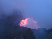
Stratovolcano
A stratovolcano, also known as a composite volcano, is a tall, conical volcano built up by many layers of hardened lava, tephra, pumice, and volcanic ash. Unlike shield volcanoes, stratovolcanoes are characterized by a steep profile and periodic, explosive eruptions...
es.
Volcanoes are popularly classified as Extinct, Dormant, or Active; but scientifically, the lines between extinct, dormant, and active can be hard to draw. Some volcanoes are also called inactive.
AfricaAfricaAfrica is the world's second largest and second most populous continent, after Asia. At about 30.2 million km² including adjacent islands, it covers 6% of the Earth's total surface area and 20.4% of the total land area...
Mid-Atlantic RidgeMid-Atlantic RidgeThe Mid-Atlantic Ridge is a mid-ocean ridge, a divergent tectonic plate boundary located along the floor of the Atlantic Ocean, and part of the longest mountain range in the world. It separates the Eurasian Plate and North American Plate in the North Atlantic, and the African Plate from the South...
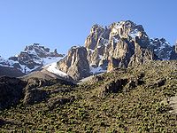
- Mount PicoMount PicoMount Pico is a stratovolcano and the highest point on Pico Island in the Azores. It reaches an altitude of 2,351 meters above sea level, which makes it the highest point in Portugal and also in the Mid-Atlantic Ridge...
in Pico IslandPico IslandPico Island , is an island in the Central Group of the Portuguese Azores noted for its eponymous volcano, Ponta do Pico, which is the highest mountain in Portugal, the Azores, and the highest elevation of the Mid-Atlantic Ridge...
, AzoresAzoresThe Archipelago of the Azores is composed of nine volcanic islands situated in the middle of the North Atlantic Ocean, and is located about west from Lisbon and about east from the east coast of North America. The islands, and their economic exclusion zone, form the Autonomous Region of the...
(active) - TeideTeideMount Teide , is a volcano on Tenerife, Canary Islands. Its summit is the highest point in Spain, the highest point above sea level in the islands of the Atlantic, and it is the third highest volcano in the world measured from its base on the ocean floor, after Mauna Loa and Mauna Kea located in...
, TenerifeTenerifeTenerife is the largest and most populous island of the seven Canary Islands, it is also the most populated island of Spain, with a land area of 2,034.38 km² and 906,854 inhabitants, 43% of the total population of the Canary Islands. About five million tourists visit Tenerife each year, the...
, Canary IslandsCanary IslandsThe Canary Islands , also known as the Canaries , is a Spanish archipelago located just off the northwest coast of mainland Africa, 100 km west of the border between Morocco and the Western Sahara. The Canaries are a Spanish autonomous community and an outermost region of the European Union...
(active) - Cumbre ViejaCumbre ViejaCumbre Vieja is an active volcanic ridge on the volcanic ocean island of Isla de La Palma in the Canary Islands.This ridge trends in an approximate north-south direction and covers the southern third of the island. It is lined by several volcanic craters....
, TenerifeTenerifeTenerife is the largest and most populous island of the seven Canary Islands, it is also the most populated island of Spain, with a land area of 2,034.38 km² and 906,854 inhabitants, 43% of the total population of the Canary Islands. About five million tourists visit Tenerife each year, the...
, Canary IslandsCanary IslandsThe Canary Islands , also known as the Canaries , is a Spanish archipelago located just off the northwest coast of mainland Africa, 100 km west of the border between Morocco and the Western Sahara. The Canaries are a Spanish autonomous community and an outermost region of the European Union...
(active) - Mount FogoMount FogoPico do Fogo is the highest peak of Cape Verde, rising to above sea level. It is an active stratovolcano lying on the island of Fogo. The main cone last erupted in 1675, causing mass emigration from the island, while a subsidiary vent erupted in 1995...
in FogoFogo, Cape VerdeFogo is an island in the Sotavento group of Cape Verde. It is the most prominent of the group, rising to nearly 3,000 m above sea level at Pico do Fogo.-Geography:...
, Cape VerdeCape VerdeThe Republic of Cape Verde is an island country, spanning an archipelago of 10 islands located in the central Atlantic Ocean, 570 kilometres off the coast of Western Africa...
(may be dormant) - Green MountainGreen MountainGreen Mountain is a common name for "The Peak", the highest point, on Ascension Island which has gained some fame for claims that it is one of very few large-scale artificial forests.-History and Vegetation:...
, Ascension IslandAscension IslandAscension Island is an isolated volcanic island in the equatorial waters of the South Atlantic Ocean, around from the coast of Africa and from the coast of South America, which is roughly midway between the horn of South America and Africa...
(may be extinct)
CaribbeanCaribbeanThe Caribbean is a crescent-shaped group of islands more than 2,000 miles long separating the Gulf of Mexico and the Caribbean Sea, to the west and south, from the Atlantic Ocean, to the east and north...
- La Grande SoufrièreLa Grande SoufrièreLa Grande Soufrière, , is an active stratovolcano located on the French island of Basse-Terre, in Guadeloupe. It is the tallest mountain in the Lesser Antilles, and rises 1,467 m high....
on the island of Basse-TerreBasse-TerreBasse-Terre is the prefecture of Guadeloupe, an overseas region and department of France located in the Lesser Antilles...
in Guadaloupe, West Indies - The Soufriere HillsSoufrière HillsThe Soufrière Hills volcano is an active complex stratovolcano with many lava domes forming its summit on the Caribbean island of Montserrat. After a long period of dormancy, it became active in 1995, and has continued to erupt ever since...
on the island of MontserratMontserratMontserrat is a British overseas territory located in the Leeward Islands, part of the chain of islands called the Lesser Antilles in the West Indies. This island measures approximately long and wide, giving of coastline...
(active) - Soufrière (volcano)Soufrière (volcano)La Soufrière [The Sulfurer] or Soufrière Saint Vincent is an active volcano on the island of Saint Vincent in the Windward Islands of the Caribbean.- Geography and structure :...
in Saint Vincent and the GrenadinesSaint Vincent and the GrenadinesSaint Vincent and the Grenadines is an island country in the Lesser Antilles chain, namely in the southern portion of the Windward Islands, which lie at the southern end of the eastern border of the Caribbean Sea where the latter meets the Atlantic Ocean....
, (active) - Mount PeléeMount PeléeMount Pelée is an active volcano at the northern end of the island and French overseas department of Martinique in the Lesser Antilles island arc of the Caribbean. Its volcanic cone is composed of layers of volcanic ash and hardened lava....
in MartiniqueMartiniqueMartinique is an island in the eastern Caribbean Sea, with a land area of . Like Guadeloupe, it is an overseas region of France, consisting of a single overseas department. To the northwest lies Dominica, to the south St Lucia, and to the southeast Barbados...
(may be dormant)
Costa RicaCosta RicaCosta Rica , officially the Republic of Costa Rica is a multilingual, multiethnic and multicultural country in Central America, bordered by Nicaragua to the north, Panama to the southeast, the Pacific Ocean to the west and the Caribbean Sea to the east....
- ArenalArenal VolcanoArenal Volcano, in Spanish , is an active andesitic stratovolcano in north-western Costa Rica around 90 km northwest of San José, in the province of Alajuela, canton of San Carlos, and district of La Fortuna....
in La Fortuna, San CarlosSan Carlos CantonSan Carlos is the name of the 10th canton in the province of Alajuela in Costa Rica. The canton covers an area of , making it the largest canton in the country. It has a population of 137,499 , ranking it fifth...
(active) - PoásPoás VolcanoThe Poás Volcano, in Spanish Volcán Poás, is an active stratovolcano in central Costa Rica. Poás has erupted 39 times since 1828.- Crater lakes :...
in AlajuelaAlajuela ProvinceAlajuela is a province of Costa Rica. It is located in the north-central part of the country, bordering Nicaragua to the north, and clockwise the provinces Heredia, San José, Puntarenas and Guanacaste...
(active) - TurrialbaTurrialba VolcanoTurrialba Volcano was named after the region of Costa Rica in which the volcano is situated in Turrialba County, Cartago of Costa Rica. There is no clear consensus on the origin of the name Turrialba, but historians disagree with attempts to attribute the name to the patronym Torrealba or from...
in Turrialba County, Cartago (active) - ChatoChato VolcanoChato Volcano, sometimes called "Cerro Chato" , is an inactive volcano in north-western Costa Rica north-west of San José, in the province of Alajuela, canton of San Carlos, and district of La Fortuna...
in La Fortuna, San CarlosSan Carlos CantonSan Carlos is the name of the 10th canton in the province of Alajuela in Costa Rica. The canton covers an area of , making it the largest canton in the country. It has a population of 137,499 , ranking it fifth...
(inactive)
El SalvadorEl SalvadorEl Salvador or simply Salvador is the smallest and the most densely populated country in Central America. The country's capital city and largest city is San Salvador; Santa Ana and San Miguel are also important cultural and commercial centers in the country and in all of Central America...
- Chaparrastique (active)
- Ilamatepec. Recently erupted: October, 2005.
- Chichontepec, (may be extinct)
- Guazapa (may be extinct)
- ChinamecaChinameca (volcano)Chinameca is a stratovolcano in central-eastern El Salvador. It lies north of San Miguel volcano and rises over the town of Chinameca. The volcano is topped by a wide caldera known as Laguna Seca el Pacayal, and a satellite cone on the west side, Cerro el Limbo, rises higher than the caldera rim...
(may be extinct) - TabureteTabureteTaburete is a stratovolcano in central El Salvador, rising above the coastal plain between the San Vicente and San Miguel volcanoes, and just west of Usulután volcano. It is topped by a well-preserved, 150–300 m deep summit crater, with the true summit on the south side of the crater rim....
(may be extinct)
GuatemalaGuatemalaGuatemala is a country in Central America bordered by Mexico to the north and west, the Pacific Ocean to the southwest, Belize to the northeast, the Caribbean to the east, and Honduras and El Salvador to the southeast...
- PacayaPacayaPacaya is an active complex volcano in Guatemala, which first erupted approximately 23,000 years ago and has erupted at least 23 times since the Spanish conquest of Guatemala. Pacaya rises to an elevation of . After being dormant for a century, it erupted violently in 1965 and has been...
(active) - AcatenangoAcatenangoAcatenango is a stratovolcano in Guatemala, close to the city of Antigua. The volcano has two peaks, Pico Mayor and Yepocapa which is also known as Tres Hermanas...
(active) - Volcan de FuegoVolcán de FuegoVolcán de Fuego is an active stratovolcano in Guatemala. It is close to the city of Antigua Guatemala. It has erupted frequently since the Spanish conquest. "Fuego" is famous for being almost constantly active at a low level. Smoke issues from its top daily, but larger eruptions are rare. On...
(active) - Santa María (active)
- Volcan de AguaVolcán de AguaVolcán de Agua is a stratovolcano located in the department of Sacatepéquez in Guatemala. It has been inactive since the mid 16th century. At 3,760 metres, Agua Volcano towers more than 3,500 metres above the Pacific coastal plain to the south and 2,000 metres above the Guatemalan...
(may be extinct)
MexicoMexicoThe United Mexican States , commonly known as Mexico , is a federal constitutional republic in North America. It is bordered on the north by the United States; on the south and west by the Pacific Ocean; on the southeast by Guatemala, Belize, and the Caribbean Sea; and on the east by the Gulf of...
- PopocatépetlPopocatépetlPopocatépetl also known as "Popochowa" by the local population is an active volcano and, at , the second highest peak in Mexico after the Pico de Orizaba...
(active) - Colima volcanoColima (volcano)The Colima Volcano is currently one of the most active volcanos in Mexico and in North America. It has erupted more than 40 times since 1576....
(active) - Nevado de TolucaNevado de TolucaNevado de Toluca is a large stratovolcano in central Mexico, located about west of Mexico City near the city of Toluca. It is generally cited as the fourth highest of Mexico's peaks, after Pico de Orizaba, Popocatépetl and Iztaccíhuatl, although by some measurements, Sierra Negra is slightly...
(may be dormant) - The Pico de OrizabaPico de OrizabaThe Pico de Orizaba, or Citlaltépetl , is a stratovolcano, the highest mountain in Mexico and the third highest in North America. It rises above sea level in the eastern end of the Trans-Mexican Volcanic Belt, on the border between the states of Veracruz and Puebla...
(may be dormant)
North AmericaNorth AmericaNorth America is a continent wholly within the Northern Hemisphere and almost wholly within the Western Hemisphere. It is also considered a northern subcontinent of the Americas...
CanadaCanadaCanada is a North American country consisting of ten provinces and three territories. Located in the northern part of the continent, it extends from the Atlantic Ocean in the east to the Pacific Ocean in the west, and northward into the Arctic Ocean...
- Mount CayleyMount CayleyMount Cayley is a potentially active stratovolcano in Squamish-Lillooet Regional District of southwestern British Columbia, Canada. Located north of Squamish and west of Whistler in the Pacific Ranges of the Coast Mountains, it rises above the Squamish River to the west and above the Cheakamus...
in southwestern British ColumbiaBritish ColumbiaBritish Columbia is the westernmost of Canada's provinces and is known for its natural beauty, as reflected in its Latin motto, Splendor sine occasu . Its name was chosen by Queen Victoria in 1858...
(may be dormant) (The Mount Cayley article contains "Scenario of an eruption"). See also Mount Cayley volcanic fieldMount Cayley volcanic fieldThe Mount Cayley volcanic field is a remote volcanic zone on the South Coast of British Columbia, Canada, stretching from the Pemberton Icefield to the Squamish River. It forms a segment of the Garibaldi Volcanic Belt, the Canadian portion of the Cascade Volcanic Arc, which extends from Northern...
. - Mount GaribaldiMount GaribaldiMount Garibaldi is a potentially active stratovolcano in the Sea to Sky Country of British Columbia, north of Vancouver, Canada. Located in the southernmost Coast Mountains, it is one of the most recognized peaks in the South Coast region, as well as British Columbia's best known volcano...
in southwestern British ColumbiaBritish ColumbiaBritish Columbia is the westernmost of Canada's provinces and is known for its natural beauty, as reflected in its Latin motto, Splendor sine occasu . Its name was chosen by Queen Victoria in 1858...
(may be dormant) - Hoodoo MountainHoodoo MountainHoodoo Mountain is a potentially active flat-topped stratovolcano in the Stikine Country of northwestern British Columbia, Canada, located northeast of Wrangell, Alaska on the north side of the lower Iskut River and east of its junction with the Stikine River...
in northwestern British ColumbiaBritish ColumbiaBritish Columbia is the westernmost of Canada's provinces and is known for its natural beauty, as reflected in its Latin motto, Splendor sine occasu . Its name was chosen by Queen Victoria in 1858...
(may be dormant) - Mount MeagerMount MeagerMount Meager, originally known as Meager Mountain, is a complex volcano in the Sea-to-Sky Corridor of southwestern British Columbia, Canada. It is located north of Vancouver at the northern end of the Pemberton Valley. Part of the Cascade Volcanic Arc of western North America, its summit is above...
in southwestern British ColumbiaBritish ColumbiaBritish Columbia is the westernmost of Canada's provinces and is known for its natural beauty, as reflected in its Latin motto, Splendor sine occasu . Its name was chosen by Queen Victoria in 1858...
- Produced Canada's youngest major catastrophic eruption (may be dormant) - Mount Price in southwestern British ColumbiaBritish ColumbiaBritish Columbia is the westernmost of Canada's provinces and is known for its natural beauty, as reflected in its Latin motto, Splendor sine occasu . Its name was chosen by Queen Victoria in 1858...
(may be dormant) - Black TuskBlack TuskBlack Tusk is a remarkably abrupt pinnacle of volcanic rock located in Garibaldi Provincial Park of British Columbia, Canada. At above sea level, the upper spire is visible from a great distance in all directions. It is particularly noticeable from the Sea-to-Sky Highway just south of Whistler,...
(may be extinct) - Mount EdzizaMount EdzizaMount Edziza is a stratovolcano in the Stikine Country of northwestern British Columbia, Canada. The volcano and the surrounding area are protected within Mount Edziza Provincial Park. It consists of a complex of multiple peaks and ridges, with several glaciers flowing in all directions. The summit...
in northwestern British ColumbiaBritish ColumbiaBritish Columbia is the westernmost of Canada's provinces and is known for its natural beauty, as reflected in its Latin motto, Splendor sine occasu . Its name was chosen by Queen Victoria in 1858...
(may be dormant) - Back River volcanic complexBack River volcanic complexThe Back River volcanic complex is an Archean stratovolcano in the Northwest Territories and Nunavut, Canada. It is located northwest of Yellowknife and to the northwest of the Back River from which it takes its name...
in the Northwest TerritoriesNorthwest TerritoriesThe Northwest Territories is a federal territory of Canada.Located in northern Canada, the territory borders Canada's two other territories, Yukon to the west and Nunavut to the east, and three provinces: British Columbia to the southwest, and Alberta and Saskatchewan to the south...
(extinct)
United StatesUnited StatesThe United States of America is a federal constitutional republic comprising fifty states and a federal district...
- Lassen PeakLassen PeakLassen Peak is the southernmost active volcano in the Cascade Range. It is part of the Cascade Volcanic Arc which is an arc that stretches from northern California to southwestern British Columbia...
in CaliforniaCaliforniaCalifornia is a state located on the West Coast of the United States. It is by far the most populous U.S. state, and the third-largest by land area...
(active) - Mount HoodMount HoodMount Hood, called Wy'east by the Multnomah tribe, is a stratovolcano in the Cascade Volcanic Arc of northern Oregon. It was formed by a subduction zone and rests in the Pacific Northwest region of the United States...
in OregonOregonOregon is a state in the Pacific Northwest region of the United States. It is located on the Pacific coast, with Washington to the north, California to the south, Nevada on the southeast and Idaho to the east. The Columbia and Snake rivers delineate much of Oregon's northern and eastern...
(active) - Mount BakerMount BakerMount Baker , also known as Koma Kulshan or simply Kulshan, is an active glaciated andesitic stratovolcano in the Cascade Volcanic Arc and the North Cascades of Washington State in the United States. It is the second-most active volcano in the range after Mount Saint Helens...
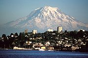
in Washington (active) - Mount RainierMount RainierMount Rainier is a massive stratovolcano located southeast of Seattle in the state of Washington, United States. It is the most topographically prominent mountain in the contiguous United States and the Cascade Volcanic Arc, with a summit elevation of . Mt. Rainier is considered one of the most...
in Washington (active) - Mount St. HelensMount St. HelensMount St. Helens is an active stratovolcano located in Skamania County, Washington, in the Pacific Northwest region of the United States. It is south of Seattle, Washington and northeast of Portland, Oregon. Mount St. Helens takes its English name from the British diplomat Lord St Helens, a...
in Washington (active) - Cleveland volcano in AlaskaAlaskaAlaska is the largest state in the United States by area. It is situated in the northwest extremity of the North American continent, with Canada to the east, the Arctic Ocean to the north, and the Pacific Ocean to the west and south, with Russia further west across the Bering Strait...
(active) - Mount RedoubtMount Redoubt (Alaska)Mount Redoubt, or Redoubt Volcano, is an active stratovolcano in the largely volcanic Aleutian Range of the U.S. state of Alaska. Located in the Chigmit Mountains , the mountain is just west of Cook Inlet, in the Kenai Peninsula Borough about 180 km southwest of Anchorage...
in AlaskaAlaskaAlaska is the largest state in the United States by area. It is situated in the northwest extremity of the North American continent, with Canada to the east, the Arctic Ocean to the north, and the Pacific Ocean to the west and south, with Russia further west across the Bering Strait...
(active) - Mount ShishaldinMount ShishaldinMount Shishaldin is a moderately active volcano on Unimak Island in the Aleutian Islands chain of Alaska. It is the tallest mountain in the Aleutian Islands. The most symmetrical cone-shaped glacier-clad large mountain on earth, the volcano's topographic contour lines are nearly perfect circles...
in AlaskaAlaskaAlaska is the largest state in the United States by area. It is situated in the northwest extremity of the North American continent, with Canada to the east, the Arctic Ocean to the north, and the Pacific Ocean to the west and south, with Russia further west across the Bering Strait...
(active) - Mount AkutanMount AkutanMount Akutan, officially Akutan Peak, is a stratovolcano in the Aleutian Islands of Alaska. Akutan Peak, at , is the highest point on the caldera of the Akutan stratovolcano. Akutan contains a 2 km-wide caldera formed during a major explosive eruption about 1600 years ago. Recent eruptive...
in AlaskaAlaskaAlaska is the largest state in the United States by area. It is situated in the northwest extremity of the North American continent, with Canada to the east, the Arctic Ocean to the north, and the Pacific Ocean to the west and south, with Russia further west across the Bering Strait...
(active) - Augustine VolcanoAugustine VolcanoAugustine Volcano is a Lava Dome Complex on Augustine Island in southwestern Cook Inlet in the Kenai Peninsula Borough of southcentral coastal Alaska, southwest of Anchorage. The Alaska Volcano Observatory currently rates Mount Augustine as Level of Concern Color Code Green for aviation and the...
, Cook InletCook InletCook Inlet stretches from the Gulf of Alaska to Anchorage in south-central Alaska. Cook Inlet branches into the Knik Arm and Turnagain Arm at its northern end, almost surrounding Anchorage....
, AlaskaAlaskaAlaska is the largest state in the United States by area. It is situated in the northwest extremity of the North American continent, with Canada to the east, the Arctic Ocean to the north, and the Pacific Ocean to the west and south, with Russia further west across the Bering Strait...
(active) - Mount KatmaiMount KatmaiMount Katmai is a large stratovolcano on the Alaska Peninsula in southern Alaska, located within Katmai National Park and Preserve. It is about in diameter with a central lake-filled caldera about 3 by 2 mi in area, formed during the Novarupta eruption of 1912. The caldera rim reaches a...
, Katmai National Park and PreserveKatmai National Park and PreserveKatmai National Park and Preserve is a United States National Park in southern Alaska, notable for the Valley of Ten Thousand Smokes and for its brown bears. The park covers , being roughly the size of Wales. Most of this is a designated wilderness area, including of the park...
, AlaskaAlaskaAlaska is the largest state in the United States by area. It is situated in the northwest extremity of the North American continent, with Canada to the east, the Arctic Ocean to the north, and the Pacific Ocean to the west and south, with Russia further west across the Bering Strait...
(active) - Mount PavlofMount PavlofPavlof Volcano is a stratovolcano of the Aleutian Range on the Alaska Peninsula. It has been one of the most active in the United States since 1980, with eruptions recorded in 1980, 1981, 1983, 1986–1988, 1996–1997, and an ongoing eruption starting on August 15, 2007 and ending on September 13...
, AlaskaAlaskaAlaska is the largest state in the United States by area. It is situated in the northwest extremity of the North American continent, with Canada to the east, the Arctic Ocean to the north, and the Pacific Ocean to the west and south, with Russia further west across the Bering Strait...
(active) - Korovin Volcano, Alaska (active)
- Glacier PeakGlacier PeakGlacier Peak is the most isolated of the five major stratovolcanoes of the Cascade Volcanic Arc in Washington...
in Washington (may be dormant) - Mount AdamsMount Adams (Washington)Mount Adams is a potentially activestratovolcano in the Cascade Range and the second-highest mountain in the U.S. state of Washington.Adams is a member of the Cascade Volcanic Arc, and is one of the arc's largest volcanoes,...
in Washington (may be dormant) - Mount BakerMount BakerMount Baker , also known as Koma Kulshan or simply Kulshan, is an active glaciated andesitic stratovolcano in the Cascade Volcanic Arc and the North Cascades of Washington State in the United States. It is the second-most active volcano in the range after Mount Saint Helens...
in Washington (may be dormant) - Mount HoodMount HoodMount Hood, called Wy'east by the Multnomah tribe, is a stratovolcano in the Cascade Volcanic Arc of northern Oregon. It was formed by a subduction zone and rests in the Pacific Northwest region of the United States...
in OregonOregonOregon is a state in the Pacific Northwest region of the United States. It is located on the Pacific coast, with Washington to the north, California to the south, Nevada on the southeast and Idaho to the east. The Columbia and Snake rivers delineate much of Oregon's northern and eastern...
(may be dormant) - Mount JeffersonMount Jefferson (Oregon)Mount Jefferson is a stratovolcano in the Cascade Volcanic Arc, part of the Cascade Range, and is the second highest mountain in Oregon. Situated in the far northeastern corner of Linn County on the Jefferson County line, about east of Corvallis, Mount Jefferson is in a rugged wilderness and is...
in Oregon (may be dormant) - Mammoth MountainMammoth MountainMammoth Mountain is a lava dome complex west of the town of Mammoth Lakes, California in the Inyo National Forest of Madera County and Mono County. It is home to a large ski area on the Mono County side....
in CaliforniaCaliforniaCalifornia is a state located on the West Coast of the United States. It is by far the most populous U.S. state, and the third-largest by land area...
(may be dormant) - Mount ShastaMount ShastaMount Shasta is located at the southern end of the Cascade Range in Siskiyou County, California and at is the second highest peak in the Cascades and the fifth highest in California...
in CaliforniaCaliforniaCalifornia is a state located on the West Coast of the United States. It is by far the most populous U.S. state, and the third-largest by land area...
(may be dormant) - Mount VsevidofMount VsevidofMount Vsevidof is a stratovolcano in the U.S. state of Alaska. Its summit is the highest point on Umnak Island, one of the eastern Aleutian Islands. Its symmetrical cone rises abruptly from its surroundings. Its most recent eruption was caused by an earthquake on March 9, 1957...
in AlaskaAlaskaAlaska is the largest state in the United States by area. It is situated in the northwest extremity of the North American continent, with Canada to the east, the Arctic Ocean to the north, and the Pacific Ocean to the west and south, with Russia further west across the Bering Strait...
(may be dormant) - South Sister in OregonOregonOregon is a state in the Pacific Northwest region of the United States. It is located on the Pacific coast, with Washington to the north, California to the south, Nevada on the southeast and Idaho to the east. The Columbia and Snake rivers delineate much of Oregon's northern and eastern...
(may be dormant) - San Francisco Mountain in ArizonaArizonaArizona ; is a state located in the southwestern region of the United States. It is also part of the western United States and the mountain west. The capital and largest city is Phoenix...
(may be dormant) - Mount Taylor in New MexicoNew MexicoNew Mexico is a state located in the southwest and western regions of the United States. New Mexico is also usually considered one of the Mountain States. With a population density of 16 per square mile, New Mexico is the sixth-most sparsely inhabited U.S...
(may be extinct)
South AmericaSouth AmericaSouth America is a continent situated in the Western Hemisphere, mostly in the Southern Hemisphere, with a relatively small portion in the Northern Hemisphere. The continent is also considered a subcontinent of the Americas. It is bordered on the west by the Pacific Ocean and on the north and east...
Chile
- LlaimaLlaimaLlaima Volcano is one of the largest and most active volcanoes in Chile. It is situated 82 km northeast of Temuco and 663 km southeast of Santiago, within the borders of Conguillío National Park.-Geography:...
(active) - IrruputuncuIrruputuncuIrruputuncu is a stratovolcano which lies on the border of Chile and Bolivia. It is a relatively small peak, lying within the collapse scarp of a debris avalanche from earlier in the Holocene, which was built up by eruptions to fill much of that feature. There are two craters lying at the summit,...
on the border of BoliviaBoliviaBolivia officially known as Plurinational State of Bolivia , is a landlocked country in central South America. It is the poorest country in South America...
and ChileChileChile ,officially the Republic of Chile , is a country in South America occupying a long, narrow coastal strip between the Andes mountains to the east and the Pacific Ocean to the west. It borders Peru to the north, Bolivia to the northeast, Argentina to the east, and the Drake Passage in the far...
(active) - Ojos del SaladoOjos del SaladoNevado Ojos del Salado is a massive stratovolcano in the Andes on the Argentina-Chile border and the highest volcano in the world at . It is also the second highest mountain in the Western Hemisphere and Southern Hemisphere and the highest in Chile...
, highest Volcano in the WorldWorldWorld is a common name for the whole of human civilization, specifically human experience, history, or the human condition in general, worldwide, i.e. anywhere on Earth....
(active). It is in the border between ArgentinaArgentinaArgentina , officially the Argentine Republic , is the second largest country in South America by land area, after Brazil. It is constituted as a federation of 23 provinces and an autonomous city, Buenos Aires...
and ChileChileChile ,officially the Republic of Chile , is a country in South America occupying a long, narrow coastal strip between the Andes mountains to the east and the Pacific Ocean to the west. It borders Peru to the north, Bolivia to the northeast, Argentina to the east, and the Drake Passage in the far...
. - VillarricaVillarrica (volcano)Villarrica is one of Chile's most active volcanoes, rising above the lake and town of the same name. The volcano is also known as Rucapillán, a Mapuche word meaning "House of the Pillán". It is the westernmost of three large stratovolcanoes that trend perpendicular to the Andean chain along the...
(active) - Cerro ArenalesCerro ArenalesCerro Arenales is a heavily ice-covered stratovolcano located in the Aisén Region of Chile, within Laguna San Rafael National Park. It towers over the southern part of the Northern Patagonian Ice Field....
(active) - Calbuco (active)
- CallaquiCallaquiCallaqui is a stratovolcano located in the Bío-Bío Region of Chile. It is a large ice-capped, basaltic andesite volcano which is elongated in the northeast-southwest direction, due to its construction along an 11 km long fissure. Numerous cinder cones and lava flows have erupted from...
(active) - Mount HudsonMount HudsonMount Hudson is a stratovolcano in southern Chile, and the site of one of the largest eruptions in the twentieth century. The mountain itself is covered by a glacier. There is a caldera at the summit from an ancient eruption; modern volcanic activity comes from inside the caldera...
(active) - CopahueCopahueCopahue is a stratovolcano on the border between Argentina and Chile. There are nine volcanic craters along a line, and the eastern summit crater contains a briny, acidic 300 m wide crater lake...
(active) - Lascar VolcanoLascar Volcano-Geographical setting:Lascar is located in the altiplano of the Antofagasta Region of northern Chile, east of the Salar de Atacama, immediately west of the Aguas Calientes volcano, and to the northeast of Laguna Lejía...
(active) - Nevados de ChillánNevados de ChillánNevados de Chillán is a group of stratovolcanoes located in the Andes of the Bío-Bío Region, Chile, and is one of the most active volcanoes in the region. It consists of three overlapping peaks, Cerro Blanco at the northwest and Volcán Viejo at the southeast, with Volcán Nuevo in the middle...
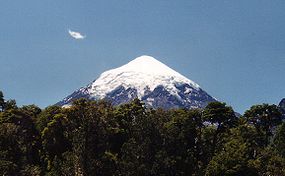
(active) - LanínLanínLanín is an ice-clad, cone-shaped stratovolcano on the border of Argentina and Chile. It forms part of two national parks: Lanín in Argentina and Villarrica in Chile. It is a symbol of the Argentine province of Neuquén, being part of its flag and its anthem. Although the date of its last eruption...
in the border between ArgentinaArgentinaArgentina , officially the Argentine Republic , is the second largest country in South America by land area, after Brazil. It is constituted as a federation of 23 provinces and an autonomous city, Buenos Aires...
and ChileChileChile ,officially the Republic of Chile , is a country in South America occupying a long, narrow coastal strip between the Andes mountains to the east and the Pacific Ocean to the west. It borders Peru to the north, Bolivia to the northeast, Argentina to the east, and the Drake Passage in the far...
(may be dormant) - AcotangoAcotangoVolcán Acotango - is the central and highest of a group of stratovolcanoes straddling the border of Bolivia and Chile. The group is known as Nevados de Quimsachata and consists, apart of Acotango, of Volcán Humarata - to its north and Cerro Capurata - on its south.The group lies along a...
on the border between BoliviaBoliviaBolivia officially known as Plurinational State of Bolivia , is a landlocked country in central South America. It is the poorest country in South America...
and ChileChileChile ,officially the Republic of Chile , is a country in South America occupying a long, narrow coastal strip between the Andes mountains to the east and the Pacific Ocean to the west. It borders Peru to the north, Bolivia to the northeast, Argentina to the east, and the Drake Passage in the far...
(may be extinct) - Cerro SoloCerro SoloCerro Solo is a large stratovolcano on the border between Argentina and Chile, west of Ojos del Salado. It consists of nine eruptive centers and is covered in light-colored rhyodacite pyroclastic flow deposits....
in PatagoniaPatagoniaPatagonia is a region located in Argentina and Chile, integrating the southernmost section of the Andes mountains to the southwest towards the Pacific ocean and from the east of the cordillera to the valleys it follows south through Colorado River towards Carmen de Patagones in the Atlantic Ocean...
along the border between ChileChileChile ,officially the Republic of Chile , is a country in South America occupying a long, narrow coastal strip between the Andes mountains to the east and the Pacific Ocean to the west. It borders Peru to the north, Bolivia to the northeast, Argentina to the east, and the Drake Passage in the far...
and ArgentinaArgentinaArgentina , officially the Argentine Republic , is the second largest country in South America by land area, after Brazil. It is constituted as a federation of 23 provinces and an autonomous city, Buenos Aires...
(may be extinct) - Parinacota, ChileChileChile ,officially the Republic of Chile , is a country in South America occupying a long, narrow coastal strip between the Andes mountains to the east and the Pacific Ocean to the west. It borders Peru to the north, Bolivia to the northeast, Argentina to the east, and the Drake Passage in the far...
. Erupted April 2008 - LicancaburLicancaburLicancabur is a highly symmetrical stratovolcano on the southernmost part of the border between Chile and Bolivia. It is located just southwest of Laguna Verde in Bolivia. The volcano dominates the landscape of the Salar de Atacama area...
(may be extinct) - Sierra NevadaSierra Nevada (stratovolcano)Sierra Nevada is a stratovolcano located in the Araucanía Region of Chile, near the Llaima volcano. Its last certain eruptions were in the Pleistocene period, but its activity may extend into the Holocene. Its primary lavas are andesitic and basaltic flows, although it has also produced pyroclastic...
(may be extinct)
EcuadorEcuadorEcuador , officially the Republic of Ecuador is a representative democratic republic in South America, bordered by Colombia on the north, Peru on the east and south, and by the Pacific Ocean to the west. It is one of only two countries in South America, along with Chile, that do not have a border...
- Pichincha Volcano (active)
- TungurahuaTungurahuaTungurahua, , rahua : "Throat of Fire" or from Panzaleo) is an active stratovolcano located in the Cordillera Oriental of Ecuador. The volcano gives its name to the province of Tungurahua...
(active) - SangaySangaySangay is a constantly active stratovolcano in central Ecuador. It is the southernmost and most active volcano in the country, and is known for its explosive venting of thick ash clouds, which has built a dome since 1976.-See also:...
(active) - ReventadorReventadorReventador is an active stratovolcano which lies in the eastern Andes of Ecuador. It lies in a remote area of the national park of the same name. Since 1541 it has erupted over 25 times, although its isolated location means that many of its eruptions have gone unreported. Its most recent eruption...
(active) - ChimborazoChimborazo (volcano)Chimborazo is a currently inactive stratovolcano located in the Cordillera Occidental range of the Andes. Its last known eruption is believed to have occurred around 550 AD....
(may be dormant) - CotopaxiCotopaxiCotopaxi is a stratovolcano in the Andes Mountains, located about south of Quito, Ecuador, South America. It is the second highest summit in the country, reaching a height of...
(may be dormant) - AntisanaAntisanaAntisana is a stratovolcano of the northern Andes, in Ecuador. It is the fourth highest volcano in Ecuador, at , and is located 50 km SE of the capital city of Quito.Antisana presents one of the most challenging technical climbs in the Ecuadorian Andes....
(may be dormant) - CayambeCayambe (volcano)Cayambe is the name of a volcano located in the Cordillera Oriental, a branch of the Ecuadorian Andes. It is located in Pichincha province some 70 km northeast of Quito. It is the third highest mountain in Ecuador....
(may be dormant) - Corazón (may be extinct)
- El AltarEl AltarEl Altar is an extinct volcano on the western side of Sangay National Park in Ecuador, 170 km south of Quito. Spaniards named it so because it resembled two Nuns and four Friars listening to a Bishop around a church altar...
(may be extinct) - CarihuairazoCarihuairazoMount Carihuairazo is a volcanic caldera neighboured by Ecuador's highest mountain Chimborazo.-Location:Carihuairazo is located in the Cordillera Occidental of the Andes of central Ecuador, south-southwest of the capital Quito. Its neighboured by 6,267 m high Chimborazo...
(may be extinct)
PeruPeruPeru , officially the Republic of Peru , is a country in western South America. It is bordered on the north by Ecuador and Colombia, on the east by Brazil, on the southeast by Bolivia, on the south by Chile, and on the west by the Pacific Ocean....
- El MistiEl MistiEl Misti, also known as Guagua-Putinais a stratovolcano located in southern Peru near the city of Arequipa. With its seasonally snow-capped, symmetrical cone, El Misti stands at above sea level and lies between the mountain Chachani and the volcano Pichu-Pichu . Its last eruption was in...
(may be dormant) near the southern city of ArequipaArequipaArequipa is the capital city of the Arequipa Region in southern Peru. With a population of 836,859 it is the second most populous city of the country... - UbinasUbinasUbinas is Peru's most recently active volcano. Until 2006, this stratovolcano had not erupted for about 40 years.- Description :Ubinas is located in southwestern Peru. The upper slopes of the volcano, composed primarily of Pleistocene andesitic lava flows, steepen to nearly 45 degrees...
(active) southwestern PeruPeruPeru , officially the Republic of Peru , is a country in western South America. It is bordered on the north by Ecuador and Colombia, on the east by Brazil, on the southeast by Bolivia, on the south by Chile, and on the west by the Pacific Ocean....
Antarctica
- Mount ErebusMount ErebusMount Erebus in Antarctica is the southernmost historically active volcano on Earth, the second highest volcano in Antarctica , and the 6th highest ultra mountain on an island. With a summit elevation of , it is located on Ross Island, which is also home to three inactive volcanoes, notably Mount...
(active) - Penguin IslandPenguin Island (South Shetland Islands)Penguin Island is an island, wide by long, which lies close off the south coast of King George Island and marks the eastern side of the entrance to King George Bay in the South Shetland Islands...
- Mount BirdMount BirdMount Bird is a stratovolcano, high, standing about south of Cape Bird, the northern extremity of Ross Island. It was mapped by the British National Antarctic Expedition, 1901–04, under Robert Falcon Scott, and apparently named by them after Cape Bird. Shell Glacier and Endeavour Piedmont Glacier...
- Brown PeakBrown Peak (Sturge Island)Brown Peak is the highest point of the Balleny Islands. It is situated on the northern part of Sturge Island, near East Antarctica. A stratovolcano, Brown Peak is considered to belong to the Balleny Islands Ranges, a subset of the Wilkes Land Coast Ranges...
- Mount DiscoveryMount DiscoveryMount Discovery is a conspicuous, isolated stratovolcano, lying at the head of McMurdo Sound and east of Koettlitz Glacier, overlooking the NW portion of the Ross Ice Shelf...
- Mount HarcourtMount HarcourtMount Harcourt is a stratovolcano making up part of the Hallett Peninsula extending into the Ross Sea about south of Mount Erebus, along with three overlapping shield volcanoes. Two dates have been obtained from the volcano's rock, roughly 5.5 and 6.6 million years in age. These samples are...
- Mount MelbourneMount MelbourneMount Melbourne is a massive stratovolcano that makes up the projection of the coast between Wood Bay and Terra Nova Bay, in Victoria Land of Antarctica....
- Mount MorningMount MorningMount Morning is a dome-shaped stratovolcano standing WSW of Mount Discovery and east of Koettlitz Glacier in Victoria Land. Discovered by the British National Antarctic Expedition which named it for the Morning, relief ship to the expedition....
- Mount OverlordMount OverlordMount Overlord is a very large mountain which is an extinct stratovolcano, situated at the northwest limit of Deception Plateau, 50 miles inland from the Ross Sea and just east of the head of Aviator Glacier in Victoria Land. Its assymetrial cone is on the edge of a plateau above Aviator Glacier...
AsiaAsiaAsia is the world's largest and most populous continent, located primarily in the eastern and northern hemispheres. It covers 8.7% of the Earth's total surface area and with approximately 3.879 billion people, it hosts 60% of the world's current human population...
IndiaIndiaIndia , officially the Republic of India , is a country in South Asia. It is the seventh-largest country by geographical area, the second-most populous country with over 1.2 billion people, and the most populous democracy in the world...
- Barren Island (Andaman Islands)Barren Island (Andaman Islands)Barren Island is located in the Andaman Sea, one of the most easterly of the Andaman Islands. It is the only confirmed active volcano in South Asia...
, the only active volcano in the Indian subcontinentIndian subcontinentThe Indian subcontinent, also Indian Subcontinent, Indo-Pak Subcontinent or South Asian Subcontinent is a region of the Asian continent on the Indian tectonic plate from the Hindu Kush or Hindu Koh, Himalayas and including the Kuen Lun and Karakoram ranges, forming a land mass which extends...
IndonesiaIndonesiaIndonesia , officially the Republic of Indonesia , is a country in Southeast Asia and Oceania. Indonesia is an archipelago comprising approximately 13,000 islands. It has 33 provinces with over 238 million people, and is the world's fourth most populous country. Indonesia is a republic, with an...
- SemeruSemeruSemeru, or Mount Semeru , is a volcano located in East Java, Indonesia. It is the highest mountain on the island of Java...
in JavaJavaJava is an island of Indonesia. With a population of 135 million , it is the world's most populous island, and one of the most densely populated regions in the world. It is home to 60% of Indonesia's population. The Indonesian capital city, Jakarta, is in west Java...
(active) - Mount AgungMount AgungMount Agung or Gunung Agung is a mountain in Bali, Indonesia. This stratovolcano is the highest point on the island. It dominates the surrounding area influencing the climate...
in BaliBaliBali is an Indonesian island located in the westernmost end of the Lesser Sunda Islands, lying between Java to the west and Lombok to the east...
(active) - Mount BaturMount BaturMount Batur is an active volcano located at the center of two concentric calderas north west of Mount Agung, Bali, Indonesia. The south east side of the larger 10×13 km caldera contains a caldera lake...
in BaliBaliBali is an Indonesian island located in the westernmost end of the Lesser Sunda Islands, lying between Java to the west and Lombok to the east...
(active) - GalunggungGalunggungMount Galunggung is an active stratovolcano in West Java, Indonesia, around 80 km southeast of the West Java provincial capital, Bandung...
(active) - KrakatoaKrakatoaKrakatoa is a volcanic island made of a'a lava in the Sunda Strait between the islands of Java and Sumatra in Indonesia. The name is used for the island group, the main island , and the volcano as a whole. The island exploded in 1883, killing approximately 40,000 people, although some estimates...
(active) - Anak Krakatau (active)
- Mount MerapiMount MerapiMount Merapi, Gunung Merapi , is an active stratovolcano located on the border between Central Java and Yogyakarta, Indonesia. It is the most active volcano in Indonesia and has erupted regularly since 1548...
in Central JavaCentral JavaCentral Java is a province of Indonesia. The administrative capital is Semarang. It is one of six provinces on the island of Java.This province is the province of high Human Development in Indonesia and its Points Development Index countries is equivalent to Lebanon. The province of Central Java...
(active) - Mount TamboraMount TamboraMount Tambora is an active stratovolcano, also known as a composite volcano, on the island of Sumbawa, Indonesia. Sumbawa is flanked both to the north and south by oceanic crust, and Tambora was formed by the active subduction zone beneath it. This raised Mount Tambora as high as , making it...
(active) - AmbangAmbangAmbang is a complex of volcanoes at the western of the northern arm of Sulawesi island, Indonesia. There are two lakes, lake Mo'oat and lake Tondok , at an elevation of 750 m. The larger of the two lakes is Mo'oat. Both of them are side by side. The volcano contains several craters up to...
(active) - Mount BromoMount BromoMount Bromo , is an active volcano and part of the Tengger massif, in East Java, Indonesia. At it is not the highest peak of the massif, but is the most well known. The massif area is one of the most visited tourist attractions in East Java, Indonesia. The volcano belongs to the Bromo Tengger...
, East JavaEast JavaEast Java is a province of Indonesia. It is located on the eastern part of the island of Java and includes neighboring Madura and islands to its east and to its north East Java is a province of Indonesia. It is located on the eastern part of the island of Java and includes neighboring Madura and...
(active) - Mount Sinabung, SumatraSumatraSumatra is an island in western Indonesia, westernmost of the Sunda Islands. It is the largest island entirely in Indonesia , and the sixth largest island in the world at 473,481 km2 with a population of 50,365,538...
(active)
IranIranIran , officially the Islamic Republic of Iran , is a country in Southern and Western Asia. The name "Iran" has been in use natively since the Sassanian era and came into use internationally in 1935, before which the country was known to the Western world as Persia...
- Mount DamavandMount DamavandMount Damāvand also known as Donbavand, a potentially active volcano and the highest peak in Iran, has a special place in Persian mythology and folklore...
(may be dormant)in IranIranIran , officially the Islamic Republic of Iran , is a country in Southern and Western Asia. The name "Iran" has been in use natively since the Sassanian era and came into use internationally in 1935, before which the country was known to the Western world as Persia... - SahandSahandSahand is a massive, heavily eroded stratovolcano in northwestern Iran. At , it is the highest mountain in the Iranian province of East Azarbaijan....
- SabalanSabalanSabalan is an inactive stratovolcano in Ardabil province of northwestern Iran. It is the third highest mountain in Iran with a permanent crater lake formed at its summit. Sabalan has a ski resort and different tourist areas such as the Sarein spa...
- BazmanBazmanBazman is a stratovolcano in a remote desert region of Sistan and Baluchestan Province in southeastern Iran. A 500-m-wide crater caps the summit of the dominantly andesitic volcano. Although no historic eruptions have been reported from Bazman, it does contain fumaroles. Its satellite cones have...
- Taftan VolcanoTaftan volcanoTaftan is an active stratovolcano in southeastern Iran situated in the Sistan and Baluchestan province. At nearly 4,000 meters above sea level, it is the highest mountain in southeastern Iran. The nearest city is Khash...
JapanJapanJapan is an island nation in East Asia. Located in the Pacific Ocean, it lies to the east of the Sea of Japan, China, North Korea, South Korea and Russia, stretching from the Sea of Okhotsk in the north to the East China Sea and Taiwan in the south...
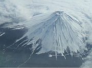
- Mount FujiMount Fujiis the highest mountain in Japan at . An active stratovolcano that last erupted in 1707–08, Mount Fuji lies about south-west of Tokyo, and can be seen from there on a clear day. Mount Fuji's exceptionally symmetrical cone is a well-known symbol of Japan and it is frequently depicted in art and...
(active) - Mount MiharaMount Miharais an active volcano on the Japanese isle of Izu Ōshima. Although the volcano is predominantly basaltic, major eruptions have occurred at intervals of 100–150 years....
on Izu OshimaIzu Oshimais a volcanic island in the Izu Islands and administered by the Tokyo Metropolitan government, Japan, lies about 100 km south of Tokyo, 22 km east of the Izu Peninsula and 36 km southwest of Bōsō Peninsula. serves as the local government of the island...
(active) - SakurajimaSakurajima, also romanized as Sakurashima or Sakura-jima, is an active composite volcano and a former island of the same name in Kagoshima Prefecture in Kyūshū, Japan...
(active) - Mount UnzenMount Unzenis an active volcanic group of several overlapping stratovolcanoes, near the city of Shimabara, Nagasaki Prefecture, on the island of Kyūshū, Japan’s southernmost main island....
(active) - Mount AdataraMount Adatarais a stratovolcano on the island of Honshū in Japan.It is located about 15 kilometres southwest of Fukushima city and east of Mount Bandai. Its last known eruption was in 1996....
(active) - Mount HarunaMount Harunais a dormant stratovolcano in Gunma, eastern Honshū, Japan.- Outline :Mount Haruna has many peaks and the tallest one, Mount Kamonga is 1,449 m high. It appeared about 300,000 years ago and the last known eruption was c. 550. The volcano has a summit caldera containing the symmetrical cone of...
(may be dormant). - Mount YufuMount Yufuis a volcano, located on the border of Yufu and Beppu, Ōita, Japan.- Outline :Mount Yufu is a Stratovolcano. It has two peaks, called ‘Higashi-mine’ and ‘Nishi-mine’ . The highest peak is Nishi-mine, which is about one meter higher than Higashi-Mine...
(may be extinct)
North KoreaNorth KoreaThe Democratic People’s Republic of Korea , , is a country in East Asia, occupying the northern half of the Korean Peninsula. Its capital and largest city is Pyongyang. The Korean Demilitarized Zone serves as the buffer zone between North Korea and South Korea...
- Baekdu MountainBaekdu MountainBaekdu Mountain, also known in China as Changbai Mountain and Baitou Mountain , is a volcanic mountain on the border between North Korea and China, located at...
, on the border between North KoreaNorth KoreaThe Democratic People’s Republic of Korea , , is a country in East Asia, occupying the northern half of the Korean Peninsula. Its capital and largest city is Pyongyang. The Korean Demilitarized Zone serves as the buffer zone between North Korea and South Korea...
and ChinaChinaChinese civilization may refer to:* China for more general discussion of the country.* Chinese culture* Greater China, the transnational community of ethnic Chinese.* History of China* Sinosphere, the area historically affected by Chinese culture...
(may be dormant)
Malaysia
- Bombalai HillBombalai HillMount Bombalai is part of a volcanic field on the Semporna peninsula in northeastern Borneo. The volcano lies in Tawau Division, Sabah, Malaysia across Cowie Harbour from the Indonesian province of East Kalimantan, and is the only volcano in the country. The low volcanic cone is located north of...
BorneoBorneoBorneo is the third largest island in the world and is located north of Java Island, Indonesia, at the geographic centre of Maritime Southeast Asia....
, (may be dormant) - Bombalai HillBombalai HillMount Bombalai is part of a volcanic field on the Semporna peninsula in northeastern Borneo. The volcano lies in Tawau Division, Sabah, Malaysia across Cowie Harbour from the Indonesian province of East Kalimantan, and is the only volcano in the country. The low volcanic cone is located north of...
, SabahSabahSabah is one of 13 member states of Malaysia. It is located on the northern portion of the island of Borneo. It is the second largest state in the country after Sarawak, which it borders on its southwest. It also shares a border with the province of East Kalimantan of Indonesia in the south...
(may be extinct)
PhilippinesPhilippinesThe Philippines , officially known as the Republic of the Philippines , is a country in Southeast Asia in the western Pacific Ocean. To its north across the Luzon Strait lies Taiwan. West across the South China Sea sits Vietnam...
- Mayon VolcanoMayon VolcanoMayon Volcano, also known as Mount Mayon, is an active volcano in the province of Albay, on the island of Luzon in the Philippines. Renowned as the "perfect cone" because of its almost symmetric conical shape, Mayon forms the northern boundary of Legazpi City, the largest city in terms of...
(active) - Taal VolcanoTaal VolcanoTaal Volcano is a complex volcano located on the island of Luzon in the Philippines. Historical eruptions are concentrated on Volcano Island, an island near the middle of Lake Taal. The lake partially fills Taal Caldera, which was formed by powerful prehistoric eruptions between 140,000 to 5,380 BP...
(active) - Mount PinatuboMount PinatuboMount Pinatubo is an active stratovolcano located on the island of Luzon, near the tripoint of the Philippine provinces of Zambales, Tarlac, and Pampanga. It is located in the Tri-Cabusilan Mountain range separating the west coast of Luzon from the central plains, and is west of the dormant and...
(active) - Mount BulusanMount BulusanMount Bulusan, or Bulusan Volcano, is the southernmost volcano on Luzon Island in the Republic of the Philippines. It is situated in the province of Sorsogon in the Bicol region, southeast of Mayon Volcano and approximately southeast of the Philippine capital of Manila.It is one of the active...
(active) - AgrihanAgrihanAgrihan is a stratovolcano which forms an island in the Northern Mariana Islands in the Pacific Ocean. The entire island is a massive volcano which rises over from the ocean floor, and is the fifth largest in the Marianas volcanic arc. At , its summit is the highest point in Micronesia...
in Mariana IslandsMariana IslandsThe Mariana Islands are an arc-shaped archipelago made up by the summits of 15 volcanic mountains in the north-western Pacific Ocean between the 12th and 21st parallels north and along the 145th meridian east...
(active) - Mount ArayatMount ArayatMount Arayat is an extinct stratovolcano on Luzon Island, Philippines, rising to a height of There is no recorded eruption of the volcano, and its last activity probably dates to the Holocene era.The volcano is located in a flat agricultural region at...
(may be dormant) - Mount IsarogMount IsarogMount Isarog is a potentially active stratovolcano located in the province of Camarines Sur, Island of Luzon, Philippines.It was here that Bicolano guerillas hid during the Japanese Period...
in Camarines SurCamarines SurCamarines Sur is a province of the Philippines located in the Bicol Region in Luzon. Its capital is Pili and the province borders Camarines Norte and Quezon to the north, and Albay to the south...
(may be dormant) - Mount TalinisMount TalinisMount Talinis, also known as the Cuernos de Negros , is a complex volcano in the Philippine province of Negros Oriental. At about above sea level, it is the second highest mountain on Negros Island after Mt. Kanla-on...
(may be dormant)
RussiaRussiaRussia or , officially known as both Russia and the Russian Federation , is a country in northern Eurasia. It is a federal semi-presidential republic, comprising 83 federal subjects...
- BezymiannyBezymiannyBezymianny is an active stratovolcano in Kamchatka, Russia. Prior to its noted 1955-56 eruption, Bezymianny volcano had been considered extinct...
(active) - Klyuchevskaya SopkaKlyuchevskaya SopkaKlyuchevskaya Sopka is a stratovolcano which is the highest mountain on the Kamchatka Peninsula of Russia and the highest active volcano of Eurasia. Its steep, symmetrical cone towers about from the Bering Sea...
or Kliuchevskoi, Kamchatka Krai, the highest active volcano in Eurasia, erupting since 1697 - ShiveluchShiveluchShiveluch is the northernmost active volcano in Kamchatka Krai, Russia. It is sometimes called Sheveluch or Sopka Shiveluch. It is one of Kamchatka's largest and most active volcanoes.- History :...
, Kamchatka Krai (active) - Avachinsky, Kamchatka Krai (active), a Decade Volcano
- KoryakskyKoryakskyKoryaksky or Koryakskaya Sopka is a volcano on the Kamchatka Peninsula in the far east of Russia. It lies within sight of Kamchatka Krai's administrative center, Petropavlovsk-Kamchatsky...
, Kamchatka Krai (active), a Decade Volcano - Karymsky, Kamchatka Krai (active)
- Mount ElbrusMount ElbrusMount Elbrus is an inactive volcano located in the western Caucasus mountain range, in Kabardino-Balkaria and Karachay-Cherkessia, Russia, near the border of Georgia. Mt. Elbrus's peak is the highest in the Caucasus, in Russia...
CaucasusCaucasus MountainsThe Caucasus Mountains is a mountain system in Eurasia between the Black Sea and the Caspian Sea in the Caucasus region .The Caucasus Mountains includes:* the Greater Caucasus Mountain Range and* the Lesser Caucasus Mountains....
(may be extinct)
TurkeyTurkeyTurkey , known officially as the Republic of Turkey , is a Eurasian country located in Western Asia and in East Thrace in Southeastern Europe...
- Mount HasanMount HasanMount Hasan is an inactive stratovolcano in Aksaray province, Turkey. With an altitude of 3,253 m , it ranks as the second highest mountain of central Anatolia...
(may be extinct) - Agri DagiMount AraratMount Ararat is a snow-capped, dormant volcanic cone in Turkey. It has two peaks: Greater Ararat and Lesser Ararat .The Ararat massif is about in diameter...
(may be dormant) TurkeyTurkeyTurkey , known officially as the Republic of Turkey , is a Eurasian country located in Western Asia and in East Thrace in Southeastern Europe...
EuropeEuropeEurope is, by convention, one of the world's seven continents. Comprising the westernmost peninsula of Eurasia, Europe is generally 'divided' from Asia to its east by the watershed divides of the Ural and Caucasus Mountains, the Ural River, the Caspian and Black Seas, and the waterways connecting...
IcelandIcelandIceland , described as the Republic of Iceland, is a Nordic and European island country in the North Atlantic Ocean, on the Mid-Atlantic Ridge. Iceland also refers to the main island of the country, which contains almost all the population and almost all the land area. The country has a population...
- AskjaAskjaAskja is a stratovolcano situated in a remote part of the central highlands of Iceland. The name Askja refers to a complex of nested calderas within the surrounding Dyngjufjöll mountains, which rise to , askja meaning box or caldera in Icelandic-Location:The region is only accessible for a few...
(active) - BárðarbungaBárðarbungaBárðarbunga is an Icelandic stratovolcano located under the ice cap of Vatnajökull glacier, rising to 2,009 m above sea level, making it the second highest mountain in Iceland, just about 101 m lower than Hvannadalshnjúkur....
(active) - EyjafjallajökullEyjafjallajökullEyjafjallajökull is one of the smaller ice caps of Iceland, situated to the north of Skógar and to the west of Mýrdalsjökull. The ice cap covers the caldera of a volcano with a summit elevation of . The volcano has erupted relatively frequently since the last glacial period, most recently in...
. Erupted in 2010. - HeklaHeklaHekla is a stratovolcano located in the south of Iceland with a height of . Hekla is one of Iceland's most active volcanoes; over 20 eruptions have occurred in and around the volcano since 874. During the Middle Ages, Icelanders called the volcano the "Gateway to Hell."Hekla is part of a volcanic...
(active) - KverkfjöllKverkfjöllThe mountain range Kverkfjöll is situated on the north-eastern border of the glacier Vatnajökull in Iceland. With their glacier Kverkjökull, they are to be found between the Vatnajökull and the Dyngjufjöll . The mountains are still active volcanoes...
(active) - SnæfellsjökullSnæfellsjökullSnæfellsjökull is a 700,000 year old stratovolcano with a glacier covering its summit in western Iceland. The name of the mountain is actually Snæfell, but it is normally called "Snæfellsjökull" to distinguish it from two other mountains with this name...
(active) - ÖræfajökullÖræfajökullÖræfajökull is an ice-covered volcano in south-east Iceland. It is the largest active volcano in the country, and on its north-western rim is Hvannadalshnúkur, the highest peak in Iceland...
(active) - KollóttadyngjaKollóttadyngjaKollóttadyngja is a volcano in Iceland. Situated in the Ódáðahraun lava-field at , its height reaches 1,177 metres, with a diameter of 6–7 km...
in North-East IcelandIcelandIceland , described as the Republic of Iceland, is a Nordic and European island country in the North Atlantic Ocean, on the Mid-Atlantic Ridge. Iceland also refers to the main island of the country, which contains almost all the population and almost all the land area. The country has a population...
(may be extinct) - SnæfellsjökullSnæfellsjökullSnæfellsjökull is a 700,000 year old stratovolcano with a glacier covering its summit in western Iceland. The name of the mountain is actually Snæfell, but it is normally called "Snæfellsjökull" to distinguish it from two other mountains with this name...
GeorgiaGeorgia (country)Georgia is a sovereign state in the Caucasus region of Eurasia. Located at the crossroads of Western Asia and Eastern Europe, it is bounded to the west by the Black Sea, to the north by Russia, to the southwest by Turkey, to the south by Armenia, and to the southeast by Azerbaijan. The capital of...
- Mount Kazbek, CaucasusCaucasus MountainsThe Caucasus Mountains is a mountain system in Eurasia between the Black Sea and the Caspian Sea in the Caucasus region .The Caucasus Mountains includes:* the Greater Caucasus Mountain Range and* the Lesser Caucasus Mountains....
(may be dormant)
ItalyItalyItaly , officially the Italian Republic languages]] under the European Charter for Regional or Minority Languages. In each of these, Italy's official name is as follows:;;;;;;;;), is a unitary parliamentary republic in South-Central Europe. To the north it borders France, Switzerland, Austria and...
- Mount EtnaMount EtnaMount Etna is an active stratovolcano on the east coast of Sicily, close to Messina and Catania. It is the tallest active volcano in Europe, currently standing high, though this varies with summit eruptions; the mountain is 21 m higher than it was in 1981.. It is the highest mountain in...
in SicilySicilySicily is a region of Italy, and is the largest island in the Mediterranean Sea. Along with the surrounding minor islands, it constitutes an autonomous region of Italy, the Regione Autonoma Siciliana Sicily has a rich and unique culture, especially with regard to the arts, music, literature,...
. Recently erupted: April, 2010. - Mount VesuviusMount VesuviusMount Vesuvius is a stratovolcano in the Gulf of Naples, Italy, about east of Naples and a short distance from the shore. It is the only volcano on the European mainland to have erupted within the last hundred years, although it is not currently erupting...
(active) - StromboliStromboliStromboli is a small island in the Tyrrhenian Sea, off the north coast of Sicily, containing one of the three active volcanoes in Italy. It is one of the eight Aeolian Islands, a volcanic arc north of Sicily. This name is a corruption of the Ancient Greek name Strongulē which was given to it...
(active) - VulcanoVulcanothumb| The Gran Cratere. A sense of scale is provided by the tourist visible near the centre of the crater.thumb|right|250px|View of Vulcano from the island of Lipari. The green islet centre left is Vulcanello, which is connected to Vulcano by an isthmus...
United KingdomUnited KingdomThe United Kingdom of Great Britain and Northern IrelandIn the United Kingdom and Dependencies, other languages have been officially recognised as legitimate autochthonous languages under the European Charter for Regional or Minority Languages...
- Glen CoeGlen CoeGlen Coe is a glen in the Highlands of Scotland. It lies in the southern part of the Lochaber committee area of Highland Council, and was formerly part of the county of Argyll. It is often considered one of the most spectacular and beautiful places in Scotland, and is a part of the designated...
, ScotlandScotlandScotland is a country that is part of the United Kingdom. Occupying the northern third of the island of Great Britain, it shares a border with England to the south and is bounded by the North Sea to the east, the Atlantic Ocean to the north and west, and the North Channel and Irish Sea to the...
(may be extinct) - ScafellsScafellsImage:Annotated Scafell range.jpg|thumb|right|300px|The Scafell range as seen looking west from Crinkle Crags. rect 23 372 252 419 Slight Side rect 173 794 560 834 Scafell East Buttress...
, Lake DistrictLake DistrictThe Lake District, also commonly known as The Lakes or Lakeland, is a mountainous region in North West England. A popular holiday destination, it is famous not only for its lakes and its mountains but also for its associations with the early 19th century poetry and writings of William Wordsworth...
, EnglandEnglandEngland is a country that is part of the United Kingdom. It shares land borders with Scotland to the north and Wales to the west; the Irish Sea is to the north west, the Celtic Sea to the south west, with the North Sea to the east and the English Channel to the south separating it from continental...
(may be extinct)
New ZealandNew ZealandNew Zealand is an island country in the south-western Pacific Ocean comprising two main landmasses and numerous smaller islands. The country is situated some east of Australia across the Tasman Sea, and roughly south of the Pacific island nations of New Caledonia, Fiji, and Tonga...
- Mount Taranaki/Egmont in Egmont National ParkEgmont National ParkEgmont National Park is located south of New Plymouth, close to the west coast of the North Island of New Zealand. It is named after the mountain which dominates its environs, which itself was named by Captain Cook after John Perceval, 2nd Earl of Egmont, the First Lord of the Admiralty who...
in North IslandNorth IslandThe North Island is one of the two main islands of New Zealand, separated from the much less populous South Island by Cook Strait. The island is in area, making it the world's 14th-largest island...
(active) - Mount NgauruhoeMount NgauruhoeMount Ngauruhoe is an active stratovolcano or composite cone in New Zealand, made from layers of lava and tephra. It is the youngest vent in the Tongariro volcanic complex on the Central Plateau of the North Island, and first erupted about 2,500 years ago...
in North Island (active) - Mount RuapehuMount RuapehuMount Ruapehu, or just Ruapehu, is an active stratovolcano at the southern end of the Taupo Volcanic Zone in New Zealand. It is 23 kilometres northeast of Ohakune and 40 kilometres southwest of the southern shore of Lake Taupo, within Tongariro National Park...
in Tongariro National ParkTongariro National ParkTongariro National Park is the oldest national park in New Zealand, located in the central North Island. It has been acknowledged by UNESCO as one of the 28 mixed cultural and natural World Heritage Sites....
(active) - White IslandWhakaari/White IslandWhakaari/White Island is an active andesite stratovolcano, situated from the east coast of the North Island of New Zealand, in the Bay of Plenty. The nearest mainland towns are Whakatane and Tauranga....
in Bay Of PlentyBay of PlentyThe Bay of Plenty , often abbreviated to BOP, is a region in the North Island of New Zealand situated around the body of water of the same name...
(active) - Banks PeninsulaBanks PeninsulaBanks Peninsula is a peninsula of volcanic origin on the east coast of the South Island of New Zealand. It has an area of approximately and encompasses two large harbours and many smaller bays and coves...
, ChristchurchChristchurchChristchurch is the largest city in the South Island of New Zealand, and the country's second-largest urban area after Auckland. It lies one third of the way down the South Island's east coast, just north of Banks Peninsula which itself, since 2006, lies within the formal limits of...
, New ZealandNew ZealandNew Zealand is an island country in the south-western Pacific Ocean comprising two main landmasses and numerous smaller islands. The country is situated some east of Australia across the Tasman Sea, and roughly south of the Pacific island nations of New Caledonia, Fiji, and Tonga...
(may be extinct)
See also
- List of shield volcanoes
- List of cinder cones
- List of lava domes
- List of subglacial volcanoes
- StratovolcanoStratovolcanoA stratovolcano, also known as a composite volcano, is a tall, conical volcano built up by many layers of hardened lava, tephra, pumice, and volcanic ash. Unlike shield volcanoes, stratovolcanoes are characterized by a steep profile and periodic, explosive eruptions...
- List of currently erupting volcanoes