
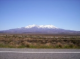
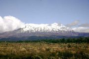
Mount Ruapehu
Encyclopedia


Stratovolcano
A stratovolcano, also known as a composite volcano, is a tall, conical volcano built up by many layers of hardened lava, tephra, pumice, and volcanic ash. Unlike shield volcanoes, stratovolcanoes are characterized by a steep profile and periodic, explosive eruptions...
at the southern end of the Taupo Volcanic Zone
Taupo Volcanic Zone
The Taupo Volcanic Zone is a highly active volcanic V shaped area in the North Island of New Zealand that is spreading east -west at the rate of about 8mm per year...
in New Zealand
New Zealand
New Zealand is an island country in the south-western Pacific Ocean comprising two main landmasses and numerous smaller islands. The country is situated some east of Australia across the Tasman Sea, and roughly south of the Pacific island nations of New Caledonia, Fiji, and Tonga...
. It is 23 kilometres northeast of Ohakune
Ohakune
Ohakune is a town in the North Island of New Zealand. It is located at the southern end of the Tongariro National Park, close to the southwestern slopes of the active volcano Mount Ruapehu. Part of the Manawatu-Wanganui region, the town is 70 kilometres northeast of Wanganui, and 25 kilometres west...
and 40 kilometres southwest of the southern shore of Lake Taupo
Lake Taupo
Lake Taupo is a lake situated in the North Island of New Zealand. With a surface area of , it is the largest lake by surface area in New Zealand, and the second largest freshwater lake by surface area in geopolitical Oceania after Lake Murray ....
, within Tongariro National Park
Tongariro National Park
Tongariro National Park is the oldest national park in New Zealand, located in the central North Island. It has been acknowledged by UNESCO as one of the 28 mixed cultural and natural World Heritage Sites....
. The North Island
North Island
The North Island is one of the two main islands of New Zealand, separated from the much less populous South Island by Cook Strait. The island is in area, making it the world's 14th-largest island...
's major skifields and only glacier
Glacier
A glacier is a large persistent body of ice that forms where the accumulation of snow exceeds its ablation over many years, often centuries. At least 0.1 km² in area and 50 m thick, but often much larger, a glacier slowly deforms and flows due to stresses induced by its weight...
s are on its slopes.
Ruapehu is one of the world's most active volcano
Volcano
2. Bedrock3. Conduit 4. Base5. Sill6. Dike7. Layers of ash emitted by the volcano8. Flank| 9. Layers of lava emitted by the volcano10. Throat11. Parasitic cone12. Lava flow13. Vent14. Crater15...
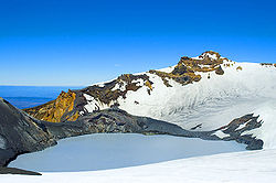
es and the largest active volcano in New Zealand. It is the highest point in the North Island and includes three major peaks: Tahurangi (2,797 m), Te Heuheu (2,755 m) and Paretetaitonga (2,751 m). The deep, active crater
Volcanic crater
A volcanic crater is a circular depression in the ground caused by volcanic activity. It is typically a basin, circular in form within which occurs a vent from which magma erupts as gases, lava, and ejecta. A crater can be of large dimensions, and sometimes of great depth...
is between the peaks and fills with a crater lake
Crater lake
A crater lake is a lake that forms in a volcanic crater or caldera, such as a maar; less commonly and with lower association to the term a lake may form in an impact crater caused by a meteorite. Sometimes lakes which form inside calderas are called caldera lakes, but often this distinction is not...
between major eruptions.
Volcanic activity

Andesite
Andesite is an extrusive igneous, volcanic rock, of intermediate composition, with aphanitic to porphyritic texture. In a general sense, it is the intermediate type between basalt and dacite. The mineral assemblage is typically dominated by plagioclase plus pyroxene and/or hornblende. Magnetite,...
and began erupting at least 250,000 years ago. In recorded history, major eruptions have been about 50 years apart, in 1895, 1945 and 1995–1996. Minor eruptions are frequent, with at least 60 since 1945. Some of the minor eruptions in the 1970s generated small ash
Volcanic ash
Volcanic ash consists of small tephra, which are bits of pulverized rock and glass created by volcanic eruptions, less than in diameter. There are three mechanisms of volcanic ash formation: gas release under decompression causing magmatic eruptions; thermal contraction from chilling on contact...
falls and lahar
Lahar
A lahar is a type of mudflow or debris flow composed of a slurry of pyroclastic material, rocky debris, and water. The material flows down from a volcano, typically along a river valley. The term is a shortened version of "berlahar" which originated in the Javanese language of...
s (mudflows) that damaged skifields.
Between major eruptions, a warm acid
Acid
An acid is a substance which reacts with a base. Commonly, acids can be identified as tasting sour, reacting with metals such as calcium, and bases like sodium carbonate. Aqueous acids have a pH of less than 7, where an acid of lower pH is typically stronger, and turn blue litmus paper red...
ic crater lake forms, fed by melting snow. Major eruptions may completely expel the lake water. Where a major eruption has deposited a tephra
Tephra
200px|thumb|right|Tephra horizons in south-central [[Iceland]]. The thick and light coloured layer at center of the photo is [[rhyolitic]] tephra from [[Hekla]]....
dam across the lake's outlet, the dam may collapse after the lake has refilled and risen above the level of its normal outlet, the outrush of water causing a large lahar. In 2000, the ERLAWS
ERLAWS
ERLAWS, the Eastern Ruapehu Lahar Alarm and Warning System, is a lahar warning system installed on Mount Ruapehu, New Zealand, following volcanic eruptions in 1995–1996. The system successfully detected and warned about a lahar in March 2007...
system was installed on the mountain to detect such a collapse and alert the relevant authorities.
1945 eruption and aftermath
The 1945 eruption emptied the crater lake and dammed the outlet with tephra. The crater slowly refilled with water, until on 24 December 1953 the tephra dam collapsed causing a lahar in the Whangaehu RiverWhangaehu River
The Whangaehu River is a large river in central North Island of New Zealand. Its headwaters are the crater lake of Mount Ruapehu on the central plateau, and it flows into the Tasman Sea eight kilometres southeast of Wanganui.-Length:...
. The lahar caused the Tangiwai disaster
Tangiwai disaster
The Tangiwai disaster on 24 December 1953 was the worst rail accident in New Zealand history. An 11-carriage overnight express from Wellington to Auckland fell into the Whangaehu River at Tangiwai, ten kilometres west of Waiouru. The bridge carrying the North Island Main Trunk Railway over the...
, with the loss of 151 lives, when the Tangiwai railway bridge across the Whangaehu River collapsed while the lahar was in full flood, just before an express train crossed it. It was already known that the river had partially undermined one of the bridge piers and the lahar finished the job, causing the bridge to collapse. Although warned of the collapsed bridge, the train driver was unable to stop the train in time and six of the carriages fell into the river.

1995-96 eruptions
Spectacular eruptions occurred during 1995 and 1996. Ruapehu had been showing signs of increased activity since late November 1994, with elevated crater lake temperatures and a series of eruptions that increased in intensity over about nine months. Several lahar were observed, both in the Whangaehu River and other areas of the mountain, between 18 September and 25 September 1995, indicating the crater lake was being emptied by the eruptions. The Department of ConservationNew Zealand Department of Conservation
The Department of Conservation , commonly known by its acronym, "DOC", is the state sector organisation which deals with the conservation of New Zealand’s natural and historic heritage...
immediately issued hazard warnings and advised people to keep off the mountain, thus ending the ski season. The eruption cloud disrupted air travel, occasionally closing airports and the central North Island airspace. Episodic eruptions continued until the end of November 1995.
Within hours of a major eruption during the night being reported on 25 September 1995, news media were trying to get live video of the eruption and amateur photographers had published eruption images on the World Wide Web
World Wide Web
The World Wide Web is a system of interlinked hypertext documents accessed via the Internet...
. A webcamera, dubbed the world's first "VolcanoCam", was set up. Since then Ruapehu has been monitored by at least one and sometimes several volcanocams.
After the 1996 eruption it was recognised that a catastrophic lahar could again occur when the crater lake burst the volcanic ash dam blocking the lake outlet. This is the same mechanism that caused the 1953 lahar. The lake gradually filled with snowmelt and had reached the level of the hard rock rim by January 2005. The lahar finally occurred on 18 March 2007 (see below).
2006 eruption
Ruapehu erupted at 10.30pm on 4 October 2006. The small eruption created a volcanic earthquake of magnitude 2.8, sending a water plume 200 m into the air and 6-m waves crashing into the wall of the crater.2007 lahar
On 18 March 2007, the tephra dam which had been holding back the crater lake burst, sending a laharLahar
A lahar is a type of mudflow or debris flow composed of a slurry of pyroclastic material, rocky debris, and water. The material flows down from a volcano, typically along a river valley. The term is a shortened version of "berlahar" which originated in the Javanese language of...
down the mountain. An estimated 1.4 million cubic metres of mud, rock, and water thundered down the Whangaehu river. The Department of Conservation had received warning signals from the lahar warning system (ERLAWS
ERLAWS
ERLAWS, the Eastern Ruapehu Lahar Alarm and Warning System, is a lahar warning system installed on Mount Ruapehu, New Zealand, following volcanic eruptions in 1995–1996. The system successfully detected and warned about a lahar in March 2007...
) at around 10:30 that morning and closed all major roads in the area (trapping thousands of motorists) and shut down the main rail system for the North Island. Luckily the river banks held and no spill overs occurred. No serious damage was done and no one was injured. One family was trapped for around 24 hours after the lahar swept away the access route to their home.
2007 eruption
At about 8:20pm on 25 September 2007 a hydrothermal eruption occurred without warning. William Pike, a 22 year old primary school teacher had a leg crushed by a rock during the eruption and a rescue operation was mounted to rescue him from the Dome Shelter near the crater. The rock crashed into the Dome Shelter, landed on him and was too heavy for his companion to lift off. Two lahars that travelled down the mountain activated warning signals from the laharLahar
A lahar is a type of mudflow or debris flow composed of a slurry of pyroclastic material, rocky debris, and water. The material flows down from a volcano, typically along a river valley. The term is a shortened version of "berlahar" which originated in the Javanese language of...
warning system and prompted some ski lodges on the mountain to be evacuated and the closure of roads in the area. The eruption was accompanied by a 7 minute long earthquake, 2.9 on the Richter Scale.
2008 warnings
On 2 May 2008 a level 1 warning was issued after GNS scientists who were monitoring the lake found irregular signs of volcanic activity. This included increased chemical changes, gases and temperature. The warning was used to let visitors know the potential of an explosion was higher than usual and could happen at any time. This could also be a follow-up to last year's 2007 eruption.A GeoNet New Zealand Bulletin was released on 21 July 2008 stating that "the current phase of volcano unrest appears to be over, however Ruapehu remains an active volcano. Future eruptions may occur without warning." However the level has remained at 1. It has been at this level since 1997.
2011 warnings
On 5 April 2011 GeoNet changed Mount Ruapehu's Volcanic Aviation Colour Code from Green to Yellow (elevated unrest above the known background). Ruapehu's Volcanic Alert Level remained at level 1 (signs of volcanic unrest).The Volcanic Aviation Colour Code was changed because a sustained period of high water temperatures in the Crater Lake (approximately 38 - 39 °C) was observed and because changes were observed in volcanic gas output, seismic activity and Crater Lake water chemistry.
Ski fields
Ruapehu has two commercial ski fields, WhakapapaWhakapapa skifield
Whakapapa, on the northern side of Mount Ruapehu in New Zealand's Tongariro National Park, is one of the mountain's two commercial skifields. The other is Turoa, located on the mountain's south-western slopes...
on the northern side and Turoa
Turoa
Turoa is a large skifield on the south western side of Mount Ruapehu, the highest mountain in the North Island of New Zealand, in Tongariro National Park. The area has been used for skiing since before the completion of the Mountain Road, but the first lifts opened in 1978.There are two beginner...
on the southern slope. They are the two largest ski fields in New Zealand, with Whakapapa the larger. The private Tukino
Tukino
Tukino ski field is located on the eastern face of Mount Ruapehu, in the central area of the North Island, New Zealand.The field is a club managed field, but open to the general public. The ski area is serviced by two tows and an over-snow vehicle giving access for skiing and snow boarding. Tukino...
field is on the east of the mountain. The season is generally from June to October but depends on snow and weather conditions. Both ski fields are accessible by car and chairlift
Chairlift
An elevated passenger ropeway, or chairlift, is a type of aerial lift, which consists of a continuously circulating steel cable loop strung between two end terminals and usually over intermediate towers, carrying a series of chairs...
s, with beginners' to advanced ski
Ski
A ski is a long, flat device worn on the foot, usually attached through a boot, designed to help the wearer slide smoothly over snow. Originally intended as an aid to travel in snowy regions, they are now mainly used for recreational and sporting purposes...
ing slopes. Limited accommodation and refreshments are available at Top o' the Bruce (the car park at the top of Bruce Road) and at the entry to Whakapapa, and elsewhere on the mountain. Alpine huts are provided for trampers and climbers.These are mainly owned by private clubs.
Weather
On 5 July 2003 about 350 skiers and 70 skifield staff were trapped on the mountain overnight at Top o'the Bruce when a sudden snow storm blew up and within a few minutes made the access road too dangerous to descend. They spent the night in relative comfort and all descended safely the next morning. Such rapidly changing conditions are typical of the weather on New Zealand mountains.
Again on Saturday 26 July 2008 skiers and staff were trapped on the mountain overnight when a fast approaching storm caused the skifield to be closed at 10:30am and made the road too dangerous for cars without chains or 4WD to leave the area. By 3pm there were still over 100 cars in the Whakapapa car park and those who had not been able to leave by that point were told to settle in for the night. All cars were able to leave safely the next morning.
See also
- List of volcanoes in New Zealand
- List of mountains of New Zealand by height
- Volcanism of New Zealand
- List of volcanic eruptions by death toll
External links
- Ruapehu Crater Climb at Peak Bagging New Zealand
- The 1996 Ruapehu Eruption Images and Information from Michigan Technical University
- Volcanic Hazards at Ruapehu Volcano - from GNS ScienceGNS ScienceGNS Science is a New Zealand Crown Research Institute. It focuses on geology, geophysics , and nuclear science ....
- Volcano Camera - Mt Ruapehu - hourly photographs from GeoNet
- Mt Ruapehu Crater Lake Lahar Threat Response from the Department of Conservation
- Ruapehu Eruption resources blog continuous since 1995 with new activity erported as it happens