

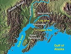
Cook Inlet
Encyclopedia
Gulf of Alaska
The Gulf of Alaska is an arm of the Pacific Ocean defined by the curve of the southern coast of Alaska, stretching from the Alaska Peninsula and Kodiak Island in the west to the Alexander Archipelago in the east, where Glacier Bay and the Inside Passage are found.The entire shoreline of the Gulf is...
to Anchorage
Anchorage, Alaska
Anchorage is a unified home rule municipality in the southcentral part of the U.S. state of Alaska. It is the northernmost major city in the United States...
in south-central Alaska
Alaska
Alaska is the largest state in the United States by area. It is situated in the northwest extremity of the North American continent, with Canada to the east, the Arctic Ocean to the north, and the Pacific Ocean to the west and south, with Russia further west across the Bering Strait...
. Cook Inlet branches into the Knik Arm and Turnagain Arm at its northern end, almost surrounding Anchorage.
The watershed
Drainage basin
A drainage basin is an extent or an area of land where surface water from rain and melting snow or ice converges to a single point, usually the exit of the basin, where the waters join another waterbody, such as a river, lake, reservoir, estuary, wetland, sea, or ocean...
covers about 100,000 km² of southern Alaska, east of the Aleutian Range
Aleutian Range
The Aleutian Range is a major mountain range of southwest Alaska, extending from Chakachamna Lake to Unimak Island, at the tip of the Alaska Peninsula. It includes all of the mountains of the Peninsula. It is especially notable for its large number of active volcanoes, which are also part of the...
and south of the Alaska Range
Alaska Range
The Alaska Range is a relatively narrow, 650-km-long mountain range in the southcentral region of the U.S. state of Alaska, from Lake Clark at its southwest end to the White River in Canada's Yukon Territory in the southeast...
, receiving water from its tributaries the Knik River, the Little Susitna River, and the Susitna
Susitna River
The Susitna River is a long river in the Southcentral Alaska. It is the 15th largest river in the United States of America, ranked by average discharge volume at its mouth. The river stretches from the Susitna Glacier to Cook Inlet....
and Matanuska
Matanuska River
The Matanuska River is a river, approximately 75 miles long, in Southcentral Alaska, United States. It drains a broad valley south of the Alaska Range known as the Matanuska-Susitna Valley....
river
River
A river is a natural watercourse, usually freshwater, flowing towards an ocean, a lake, a sea, or another river. In a few cases, a river simply flows into the ground or dries up completely before reaching another body of water. Small rivers may also be called by several other names, including...
s. The watershed includes the drainage areas of Mount McKinley
Mount McKinley
Mount McKinley or Denali in Alaska, United States is the highest mountain peak in North America and the United States, with a summit elevation of above sea level. It is the centerpiece of Denali National Park and Preserve.- Geology and features :Mount McKinley is a granitic pluton...
. Within the watershed there are several national park
National park
A national park is a reserve of natural, semi-natural, or developed land that a sovereign state declares or owns. Although individual nations designate their own national parks differently A national park is a reserve of natural, semi-natural, or developed land that a sovereign state declares or...
s and the active volcano Mount Redoubt
Mount Redoubt (Alaska)
Mount Redoubt, or Redoubt Volcano, is an active stratovolcano in the largely volcanic Aleutian Range of the U.S. state of Alaska. Located in the Chigmit Mountains , the mountain is just west of Cook Inlet, in the Kenai Peninsula Borough about 180 km southwest of Anchorage...
, along with three other historically active volcano
Volcano
2. Bedrock3. Conduit 4. Base5. Sill6. Dike7. Layers of ash emitted by the volcano8. Flank| 9. Layers of lava emitted by the volcano10. Throat11. Parasitic cone12. Lava flow13. Vent14. Crater15...
es. Cook Inlet provides navigable access to the port
Port
A port is a location on a coast or shore containing one or more harbors where ships can dock and transfer people or cargo to or from land....
of Anchorage at the northern end, and to the smaller Homer
Homer, Alaska
Homer is a city located in Kenai Peninsula Borough in the U.S. state of Alaska. According to 2005 Census Bureau estimates, the population was 5,364. One of Homer's nicknames is "the cosmic hamlet by the sea"; another is "the end of the road"...
port further south. Approximately 400,000 people live within the Cook Inlet watershed. Before the growth of Anchorage, Knik was the destination for most marine traffic in upper Cook Inlet.
Geography
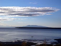
The Cook Inlet region contains active volcanoes, including Augustine VolcanoAugustine Volcano
Augustine Volcano is a Lava Dome Complex on Augustine Island in southwestern Cook Inlet in the Kenai Peninsula Borough of southcentral coastal Alaska, southwest of Anchorage. The Alaska Volcano Observatory currently rates Mount Augustine as Level of Concern Color Code Green for aviation and the...
and Mount Redoubt
Mount Redoubt
Mount Redoubt is the name of three mountains:* Mount Redoubt in Alaska, United States* Mount Redoubt in Washington, United States* Redoubt Mountain in Banff National Park, Canada...
. Volcanic eruptions in the region have been associated with earthquake
Earthquake
An earthquake is the result of a sudden release of energy in the Earth's crust that creates seismic waves. The seismicity, seismism or seismic activity of an area refers to the frequency, type and size of earthquakes experienced over a period of time...
s and tsunami
Tsunami
A tsunami is a series of water waves caused by the displacement of a large volume of a body of water, typically an ocean or a large lake...
s, and debris avalanche
Avalanche
An avalanche is a sudden rapid flow of snow down a slope, occurring when either natural triggers or human activity causes a critical escalating transition from the slow equilibrium evolution of the snow pack. Typically occurring in mountainous terrain, an avalanche can mix air and water with the...
s have resulted in tsunamis also. There was an earthquake of the magnitude of 7.1 on December 31, 1901 generated by an eruption that caused several tsunamis.
In 2009 a lahar
Lahar
A lahar is a type of mudflow or debris flow composed of a slurry of pyroclastic material, rocky debris, and water. The material flows down from a volcano, typically along a river valley. The term is a shortened version of "berlahar" which originated in the Javanese language of...
from Mt. Redoubt threatened the Drift River oil terminal.
History
Promyshlenniki
The Promyshlenniki were a group of Russian and native Siberian contract workers drawn largely from the State serf and townsman class engaged primarily in the fur trade in Siberia and Alaska in the 1790s...
) were among the first European visitors. The Lebedev Lastochkin Company leader Stepan Zaikov established a post at the mouth of the Kenai River, Fort Nikolaev, in 1786. These fur trappers used Siberian Native and Alaska Natives, particularly Aleuts from the Aleutian Islands and Koniag natives from Kodiak
Kodiak, Alaska
Kodiak is one of 7 communities and the main city on Kodiak Island, Kodiak Island Borough, in the U.S. state of Alaska. All commercial transportation between the entire island and the outside world goes through this city either via ferryboat or airline...
, to hunt for sea otter
Sea Otter
The sea otter is a marine mammal native to the coasts of the northern and eastern North Pacific Ocean. Adult sea otters typically weigh between 14 and 45 kg , making them the heaviest members of the weasel family, but among the smallest marine mammals...
s and other marine mammal species for trade with China
China
Chinese civilization may refer to:* China for more general discussion of the country.* Chinese culture* Greater China, the transnational community of ethnic Chinese.* History of China* Sinosphere, the area historically affected by Chinese culture...
via Russia's then-exclusive inland port of trade at Kiakhta.
Other Europe
Europe
Europe is, by convention, one of the world's seven continents. Comprising the westernmost peninsula of Eurasia, Europe is generally 'divided' from Asia to its east by the watershed divides of the Ural and Caucasus Mountains, the Ural River, the Caspian and Black Seas, and the waterways connecting...
ans to visit Cook Inlet include the 1778 expedition of James Cook
James Cook
Captain James Cook, FRS, RN was a British explorer, navigator and cartographer who ultimately rose to the rank of captain in the Royal Navy...
who sailed into it while searching for the Northwest Passage
Northwest Passage
The Northwest Passage is a sea route through the Arctic Ocean, along the northern coast of North America via waterways amidst the Canadian Arctic Archipelago, connecting the Atlantic and Pacific Oceans...
. Cook received maps of Alaska, the Aleutians, and Kamchatka during a visit with Russian fur trader Gerasim Izmailov in Unalaska
Unalaska, Alaska
Unalaska is a city in the Aleutians West Census Area of the Unorganized Borough of the U.S. state of Alaska. Unalaska is located on Unalaska Island and neighboring Amaknak Island in the Aleutian Islands off of mainland Alaska....
, and combined these maps with those of his expedition to create the first Mercator projection
Mercator projection
The Mercator projection is a cylindrical map projection presented by the Belgian geographer and cartographer Gerardus Mercator, in 1569. It became the standard map projection for nautical purposes because of its ability to represent lines of constant course, known as rhumb lines or loxodromes, as...
of the North Pacific. The inlet was named after Cook in 1794 by George Vancouver
George Vancouver
Captain George Vancouver RN was an English officer of the British Royal Navy, best known for his 1791-95 expedition, which explored and charted North America's northwestern Pacific Coast regions, including the coasts of contemporary Alaska, British Columbia, Washington and Oregon...
, who had served under Cook in 1778. Turnagain Arm was named by William Bligh
William Bligh
Vice Admiral William Bligh FRS RN was an officer of the British Royal Navy and a colonial administrator. A notorious mutiny occurred during his command of HMAV Bounty in 1789; Bligh and his loyal men made a remarkable voyage to Timor, after being set adrift in the Bounty's launch by the mutineers...
of HMS Bounty
HMS Bounty
HMS Bounty , famous as the scene of the Mutiny on the Bounty on 28 April 1789, was originally a three-masted cargo ship, the Bethia, purchased by the British Admiralty, then modified and commissioned as His Majesty's Armed Vessel the...
fame. Bligh served as Cook's Sailing Master on his 3rd and final voyage, with the aim to discover the Northwest Passage
Northwest Passage
The Northwest Passage is a sea route through the Arctic Ocean, along the northern coast of North America via waterways amidst the Canadian Arctic Archipelago, connecting the Atlantic and Pacific Oceans...
.
Upon reaching the head of Cook Inlet, Bligh was of the opinion that both Knik Arm and Turnagain Arm were the mouths of rivers and not the opening to the Northwest Passage. Under Cook's orders Bligh organized a party to travel up Knik Arm, which quickly returned to report Knik Arm indeed led only to a river.
Afterwards a second party was dispatched up Turnagain Arm and it too returned to report only a river lay ahead. As a result of this frustration the second body of water was given the disingenuous name "Turn Again". Early maps label Turnagain Arm as the "Turnagain River".
The S.S. Farallon was a wooden Alaskan Steamship Company liner that struck
Farallon Steamship Disaster
The Farallon Steamship Disaster was the shipwreck of a wooden Alaskan Steamship Company liner, the S.S. Farallon, that hit Black Reef in the Cook Inlet of the Farallon Islands, Alaska, on January 5, 1910. Caught in a blinding snow storm, with extremely high gales, the steamer ran aground on the...
Black Reef in the Cook Inlet on January 5th, 1910. All thirty-eight men on board survived, and were rescued twenty-nine days later. Few white people visited upper Cook Inlet until construction of the Alaska Railroad
Alaska Railroad
The Alaska Railroad is a Class II railroad which extends from Seward and Whittier, in the south of the state of Alaska, in the United States, to Fairbanks , and beyond to Eielson Air Force Base and Fort Wainwright in the interior of that state...
along the eastern shores of Turnagain Arm and Knik Arm of Cook Inlet around 1915. The natives of the Eklutna
Eklutna, Alaska
Eklutna is a native village within the Municipality of Anchorage in the U.S. state of Alaska. The Tribal Council estimates the population at 70; many tribal members live in the surrounding communities....
village are the descendants of the residents of eight native villages around upper Cook Inlet.
Communities
Most of Alaska's population surrounds Cook Inlet, concentrated in the Anchorage, AlaskaAnchorage, Alaska
Anchorage is a unified home rule municipality in the southcentral part of the U.S. state of Alaska. It is the northernmost major city in the United States...
area and in communities on the Kenai Peninsula
Kenai Peninsula
The Kenai Peninsula is a large peninsula jutting from the southern coast of Alaska in the United States. The name Kenai is probably derived from Kenayskaya, the Russian name for Cook Inlet, which borders the peninsula to the west.-Geography:...
. The more remote west side of the inlet is not connected to the road system, and is home to the village of Tyonek, Alaska, and a number of oil camps.
Resources
Alaska has approximately half the known coal reserves in the U.S. For decades, there has been a proposal to build a large coal mine (the Chuitna Coal Mine
Chuitna Coal Project
The Chuitna Coal Project is a proposed coal strip mine that, if granted state and federal permits, would be built about southwest of Anchorage, Alaska, in an area known as the Beluga Coal Fields near the Chuitna River and the small communities of Tyonek and Beluga in upper Cook Inlet.-Proposal:The...
) on the west side of Cook Inlet near the Chuitna River
Chuitna River (Alaska)
The Chuitna River, sometimes called the Chuit, emerges from a broad expanse of forest and wetlands west of Anchorage and drains into Cook Inlet. The river and its tributaries support all five species of Pacific salmon, Dolly Varden and trout, and the region is home to abundant wildlife, including...
, and the native village of Tyonek, Alaska. American Rivers has placed the Chuitna River
Chuitna River (Alaska)
The Chuitna River, sometimes called the Chuit, emerges from a broad expanse of forest and wetlands west of Anchorage and drains into Cook Inlet. The river and its tributaries support all five species of Pacific salmon, Dolly Varden and trout, and the region is home to abundant wildlife, including...
on its list of the 10 most endangered rivers for 2007, based on the threat of this mine.
Tidal bore
A tidal bore is a tidal phenomenon in which the leading edge of the incoming tide forms a wave of water that travel up a river or narrow bay against the direction of the river or bay's current...
. The bore may be more than six feet high and travel at 15 miles per hour on high spring tides. Turnagain Arm sees the largest tidal range
Tidal range
The tidal range is the vertical difference between the high tide and the succeeding low tide. Tides are the rise and fall of sea levels caused by the combined effects of the gravitational forces exerted by the Moon and the Sun and the rotation of the Earth...
in United States, with a mean of 30 feet (9.2 m), and the fourth highest in the world, behind Bay of Fundy
Bay of Fundy
The Bay of Fundy is a bay on the Atlantic coast of North America, on the northeast end of the Gulf of Maine between the Canadian provinces of New Brunswick and Nova Scotia, with a small portion touching the U.S. state of Maine...
(11.7m), Ungava Bay
Ungava Bay
Ungava Bay is a large bay in northeastern Canada separating Nunavik from Baffin Island. The bay is shaped like a rounded square with a side length of about and has an area of approximately...
(9.75m), and Bristol Channel
Bristol Channel
The Bristol Channel is a major inlet in the island of Great Britain, separating South Wales from Devon and Somerset in South West England. It extends from the lower estuary of the River Severn to the North Atlantic Ocean...
(9.6m). The ocean's natural 12-hour 25-minute tidal cycle is close to Turnagain Arm's natural resonance frequency, which then reinforces the tide similar to water sloshing in a bathtub. Tidal fluctuations in the main body of Cook Inlet, while not as extreme as the shallow and narrow Turnagain Arm, regularly reach 25 feet (7.6 m) and exhibit currents in excess of 5 knots (9.8 km/h) at full tidal flow. The inlet and its arms have been proposed as a potentially attractive site for the generation of tidal power
Tidal power
Tidal power, also called tidal energy, is a form of hydropower that converts the energy of tides into useful forms of power - mainly electricity....
.
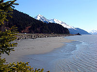
Turnagain Arm and Knik Arm are known for their abundance of silt
Silt
Silt is granular material of a size somewhere between sand and clay whose mineral origin is quartz and feldspar. Silt may occur as a soil or as suspended sediment in a surface water body...
. At low tide, much of the arms' silty bottoms are exposed, making marine navigation difficult. Historically ships and boats designed for the area had a relatively flat bottom with a modest centerboard and absence of a large keel because the boats would occasionally become beached at low tide either on purpose or by accident. This design allowed the craft to support its weight on land without sustaining any serious damage to its structure. An example of this design is the Nomad, a much photographed fishing boat once owned by Joe Reddington which has sat on a mudflat near Knik for several decades.
These mudflats can also be dangerous to walk on, exhibiting quicksand
Quicksand
Quicksand is a colloid hydrogel consisting of fine granular matter , clay, and water.Water circulation underground can focus in an area with the optimal mixture of fine sands and other materials such as clay. The water moves up and then down slowly in a convection-like manner throughout a column...
-like characteristics, and have claimed the life of at least one beach explorer who has wandered out on them.
Cruise ships dock at Seward
Seward, Alaska
Seward is a city in Kenai Peninsula Borough in the U.S. state of Alaska. According to 2005 Census Bureau estimates, the population of the city is 3,016....
on the Gulf of Alaska
Gulf of Alaska
The Gulf of Alaska is an arm of the Pacific Ocean defined by the curve of the southern coast of Alaska, stretching from the Alaska Peninsula and Kodiak Island in the west to the Alexander Archipelago in the east, where Glacier Bay and the Inside Passage are found.The entire shoreline of the Gulf is...
or Whittier
Whittier, Alaska
Whittier is a city in the Valdez-Cordova Census Area, in the U.S. state of Alaska. As of 2006, the population was 177. The city is also a port for the Alaska Marine Highway.-Geography:...
in Prince William Sound
Prince William Sound
Prince William Sound is a sound off the Gulf of Alaska on the south coast of the U.S. state of Alaska. It is located on the east side of the Kenai Peninsula. Its largest port is Valdez, at the southern terminus of the Trans-Alaska Pipeline System...
and transport passengers via bus or train to Anchorage. However, over 95% of freight entering Alaska comes through the Port of Anchorage
Port of Anchorage
The Port of Anchorage is a critical link between the U.S. state and Alaska, providing an estimated 90% of the merchandise cargo to 80% of Alaska's populated areas. The Port of Anchorage also provides essential fuel supplies to the Anchorge and southcentral area and serves as the entry point for...
, which is served by major container ship
Container ship
Container ships are cargo ships that carry all of their load in truck-size intermodal containers, in a technique called containerization. They form a common means of commercial intermodal freight transport.-History:...
companies and other carriers.
Conservation

Cook Inlet activities include commercial fishing, oil and gas development, municipal discharges, noise from aircraft and ships, shipping traffic, and tourism. However, it is not known what impact these activities had on the beluga whale population.
In 2000, the US National Marine Fisheries Service listed the Cook Inlet beluga whale population as depleted and began development of a conservation plan. On October 22, 2008 the Cook Inlet beluga whale was put onto the endangered species list.
The Coastal Marine Institute at the University of Alaska Fairbanks's School of Fisheries and Ocean Sciences working with the U.S. Department of the Interior's Minerals Management Service (MMS), began a three year project in 2003 focusing on the water circulation in Cook Inlet.
See also
- Alaska Wildlife Conservation CenterAlaska Wildlife Conservation CenterThe Alaska Wildlife Conservation Center is a conservation center dedicated to preserving Alaska's wildlife. The center is located on at the southern edge of Turnagain Arm and the entrance to Portage Valley in the Municipality of Anchorage....
- Augustine VolcanoAugustine VolcanoAugustine Volcano is a Lava Dome Complex on Augustine Island in southwestern Cook Inlet in the Kenai Peninsula Borough of southcentral coastal Alaska, southwest of Anchorage. The Alaska Volcano Observatory currently rates Mount Augustine as Level of Concern Color Code Green for aviation and the...
- Knik Arm BridgeKnik Arm BridgeThe Knik Arm Bridge is a controversial proposed highway crossing of the Knik Arm portion of Cook Inlet, north of Anchorage, Alaska. The project has also been referred to as "Don Young's Way", after Alaskan Congressman Don Young who strongly supported the project when he was Chair of the House...
- Lake Clark National Park