
List of shield volcanoes
Encyclopedia
This list of shield volcanoes includes active, dormant and extinct shield volcanoes.


Io
Io, a moon of Jupiter, has several Volcanoes that spew Sulphur.Some of these include Pele and Tohil Mons.
United States
- HualalaiHualalaiHualālai is a dormant shield volcano on the island of Hawaii in the Hawaiian Islands. It is the third-youngest and the third most active of the five volcanoes that form the island of Hawaii, following Kīlauea and the much larger Mauna Loa, and also the westernmost. Its peak is above sea...
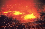
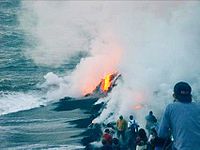
(Hawai'i) - KīlaueaKilaueaKīlauea is a volcano in the Hawaiian Islands, and one of five shield volcanoes that together form the island of Hawaii. Kīlauea means "spewing" or "much spreading" in the Hawaiian language, referring to its frequent outpouring of lava. The Puu Ōō cone has been continuously erupting in the eastern...
(Hawai'i) - Mauna LoaMauna LoaMauna Loa is one of five volcanoes that form the Island of Hawaii in the U.S. state of Hawaii in the Pacific Ocean, and the largest on Earth in terms of volume and area covered. It is an active shield volcano, with a volume estimated at approximately , although its peak is about lower than that...
(Hawai'i) - Mount OkmokMount OkmokMount Okmok is the highest point on the rim of Okmok Caldera on the northeastern part of Umnak Island in the eastern Aleutian Islands of Alaska, USA. This 5.8 mile wide circular caldera truncates the top of a large shield volcano...
(Umnak Island, Alaska)
Canada
- Lava plateau of the Mount Edziza volcanic complexMount Edziza volcanic complexThe Mount Edziza volcanic complex is a large and potentially active north-south trending complex volcano in Stikine Country, northwestern British Columbia, Canada, located southeast of the small community of Telegraph Creek...
(British ColumbiaBritish ColumbiaBritish Columbia is the westernmost of Canada's provinces and is known for its natural beauty, as reflected in its Latin motto, Splendor sine occasu . Its name was chosen by Queen Victoria in 1858...
, CanadaCanadaCanada is a North American country consisting of ten provinces and three territories. Located in the northern part of the continent, it extends from the Atlantic Ocean in the east to the Pacific Ocean in the west, and northward into the Arctic Ocean...
)
Ecuador
- Alcedo VolcanoAlcedo VolcanoAlcedo Volcano is one of the six coalescing shield volcanoes that make up Isabela Island in the Galapagos. The remote location of the volcano has meant that even the most recent eruption in 1993 was not recorded until two years later...
, Galápagos IslandsGalápagos IslandsThe Galápagos Islands are an archipelago of volcanic islands distributed around the equator in the Pacific Ocean, west of continental Ecuador, of which they are a part.The Galápagos Islands and its surrounding waters form an Ecuadorian province, a national park, and a... - La CumbreLa Cumbre (Galápagos Islands)La Cumbre is a volcano on Fernandina Island in the Galápagos Islands.It began erupting again in April 2009; according to an AOL online news report, it last erupted four years ago. The lava flows into the ocean could disrupt and destroy unique flora and fauna of the area. La Cumbre is the most...
, Galápagos IslandsGalápagos IslandsThe Galápagos Islands are an archipelago of volcanic islands distributed around the equator in the Pacific Ocean, west of continental Ecuador, of which they are a part.The Galápagos Islands and its surrounding waters form an Ecuadorian province, a national park, and a... - Sierra NegraSierra Negra (Galápagos)Sierra Negra is a large shield volcano at the South eastern end of Isabela Island in the Galapagos that rises to an altitude of 1124m. It coalesces with the volcanoes Cerro Azul to the west and Alcedo to the north...
, Galápagos IslandsGalápagos IslandsThe Galápagos Islands are an archipelago of volcanic islands distributed around the equator in the Pacific Ocean, west of continental Ecuador, of which they are a part.The Galápagos Islands and its surrounding waters form an Ecuadorian province, a national park, and a... - Cerro AzulCerro Azul (Ecuador volcano)Cerro Azul is a shield volcano on the south western part of Isabela Island in the Galápagos Islands, the name translates from Spanish as blue mountain...
, Galápagos IslandsGalápagos IslandsThe Galápagos Islands are an archipelago of volcanic islands distributed around the equator in the Pacific Ocean, west of continental Ecuador, of which they are a part.The Galápagos Islands and its surrounding waters form an Ecuadorian province, a national park, and a... - Fernandina IslandFernandina IslandFernandina Island is the third largest, and youngest, island of the Galápagos Islands. Like the others, the island was formed by the Galápagos hotspot...
, Galápagos IslandsGalápagos IslandsThe Galápagos Islands are an archipelago of volcanic islands distributed around the equator in the Pacific Ocean, west of continental Ecuador, of which they are a part.The Galápagos Islands and its surrounding waters form an Ecuadorian province, a national park, and a...
Other
- The BarrierThe Barrier (volcano)The Barrier is a shield volcano located in Kenya. It is known to have last erupted in 1921....
(KenyaKenyaKenya , officially known as the Republic of Kenya, is a country in East Africa that lies on the equator, with the Indian Ocean to its south-east...
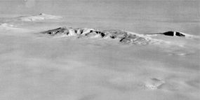
) - Bottom half of Mount ErebusMount ErebusMount Erebus in Antarctica is the southernmost historically active volcano on Earth, the second highest volcano in Antarctica , and the 6th highest ultra mountain on an island. With a summit elevation of , it is located on Ross Island, which is also home to three inactive volcanoes, notably Mount...
(Ross DependencyRoss DependencyThe Ross Dependency is a region of Antarctica defined by a sector originating at the South Pole, passing along longitudes 160° east to 150° west, and terminating at latitude 60° south...
, Antarctica) - Erta AleErta AleErta Ale is a continuously active basaltic shield volcano in the Afar Region of northeastern Ethiopia, the most active volcano in Ethiopia. It is in the Afar Depression, a badlands desert area spanning the border with Eritrea, and the volcano itself is surrounded completely by an area below sea...
(EthiopiaEthiopiaEthiopia , officially known as the Federal Democratic Republic of Ethiopia, is a country located in the Horn of Africa. It is the second-most populous nation in Africa, with over 82 million inhabitants, and the tenth-largest by area, occupying 1,100,000 km2...
) - Bottom half of Mount EtnaMount EtnaMount Etna is an active stratovolcano on the east coast of Sicily, close to Messina and Catania. It is the tallest active volcano in Europe, currently standing high, though this varies with summit eruptions; the mountain is 21 m higher than it was in 1981.. It is the highest mountain in...
(SicilySicilySicily is a region of Italy, and is the largest island in the Mediterranean Sea. Along with the surrounding minor islands, it constitutes an autonomous region of Italy, the Regione Autonoma Siciliana Sicily has a rich and unique culture, especially with regard to the arts, music, literature,...
, ItalyItalyItaly , officially the Italian Republic languages]] under the European Charter for Regional or Minority Languages. In each of these, Italy's official name is as follows:;;;;;;;;), is a unitary parliamentary republic in South-Central Europe. To the north it borders France, Switzerland, Austria and...
) - Mount KarthalaMount KarthalaKarthala is an active volcano and the highest point of the Comoros at above sea level. It is the southernmost and larger of the two shield volcanoes forming Grande Comore island, the largest island in the nation of Comoros. The Karthala volcano is notoriously active, having erupted more than 20...
(ComorosComorosThe Comoros , officially the Union of the Comoros is an archipelago island nation in the Indian Ocean, located off the eastern coast of Africa, on the northern end of the Mozambique Channel, between northeastern Mozambique and northwestern Madagascar...
) - Niuafo'ouNiuafo'ouNiuafoou is the most northerly island in the kingdom of Tonga. It is a volcanic rim island of 15 km² and with a population of 650 in 2006.-Geography:...
(TongaTongaTonga, officially the Kingdom of Tonga , is a state and an archipelago in the South Pacific Ocean, comprising 176 islands scattered over of ocean in the South Pacific...
) - Mount NyamuragiraMount NyamuragiraNyamuragira is an active volcano in the Virunga Mountains of the Democratic Republic of the Congo, situated about 25 km north of Lake Kivu.It has been described as Africa's most active volcano and has erupted over 40 times since 1885...
(Democratic Republic of the CongoDemocratic Republic of the CongoThe Democratic Republic of the Congo is a state located in Central Africa. It is the second largest country in Africa by area and the eleventh largest in the world...
) - Piton de la FournaisePiton de la FournaisePiton de la Fournaise : "Peak of the Furnace" is a shield volcano on the eastern side of Réunion island in the Indian Ocean. It is currently one of the most active volcanoes in the world, along with Kīlauea in the Hawaiian Islands , Stromboli, Etna and Mount Erebus in Antarctica...
(RéunionRéunionRéunion is a French island with a population of about 800,000 located in the Indian Ocean, east of Madagascar, about south west of Mauritius, the nearest island.Administratively, Réunion is one of the overseas departments of France...
, FranceFranceThe French Republic , The French Republic , The French Republic , (commonly known as France , is a unitary semi-presidential republic in Western Europe with several overseas territories and islands located on other continents and in the Indian, Pacific, and Atlantic oceans. Metropolitan France...
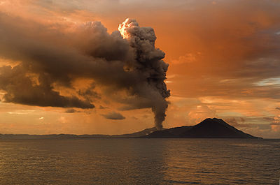
) - Masaya VolcanoMasaya VolcanoMasaya is a shield volcano located 20 km south of Managua, Nicaragua. It is Nicaragua's first and largest National Park, and one of 78 protected areas of Nicaragua. The volcanic complex is composed of a nested set of calderas and craters, the largest of which is Las Sierras shield volcano and...
, NicaraguaNicaraguaNicaragua is the largest country in the Central American American isthmus, bordered by Honduras to the north and Costa Rica to the south. The country is situated between 11 and 14 degrees north of the Equator in the Northern Hemisphere, which places it entirely within the tropics. The Pacific Ocean...
Canada
- Heart PeaksHeart PeaksHeart Peaks, originally known as the Heart Mountains, is a mountain massif in the Northern Interior of British Columbia, Canada. It is located northwest of the small community of Telegraph Creek and just southwest of Callison Ranch. With a maximum elevation of , it rises above the surrounding...
- Itcha RangeItcha RangeThe Itcha Range is a mountain range on the Chilcotin Plateau of the West-Central Interior of British Columbia, Canada. The range is located 25 miles northeast of Anahim Lake...
(British ColumbiaBritish ColumbiaBritish Columbia is the westernmost of Canada's provinces and is known for its natural beauty, as reflected in its Latin motto, Splendor sine occasu . Its name was chosen by Queen Victoria in 1858...
, CanadaCanadaCanada is a North American country consisting of ten provinces and three territories. Located in the northern part of the continent, it extends from the Atlantic Ocean in the east to the Pacific Ocean in the west, and northward into the Arctic Ocean...
) - Lava plateau of the Level Mountain RangeLevel Mountain RangeThe Level Mountain Range, also known as Level Mountain, is a mountain range in Cassiar Country, northwestern British Columbia, Canada, located just northeast of Callison Ranch, southwest of Dease Lake and about north of Mount Edziza. It consists of a massive shield volcano and lies on the Nahlin...
(British ColumbiaBritish ColumbiaBritish Columbia is the westernmost of Canada's provinces and is known for its natural beauty, as reflected in its Latin motto, Splendor sine occasu . Its name was chosen by Queen Victoria in 1858...
, CanadaCanadaCanada is a North American country consisting of ten provinces and three territories. Located in the northern part of the continent, it extends from the Atlantic Ocean in the east to the Pacific Ocean in the west, and northward into the Arctic Ocean...
)
United States
- Newberry VolcanoNewberry VolcanoNewberry Volcano is a large potentially active shield volcano located east of the Cascade Range and about southeast of Bend, Oregon. It is not a typical shield volcano. In addition to erupting basaltic lavas, it also has erupted andesitic and even rhyolitic lava.The volcano is in diameter and...
in central OregonOregonOregon is a state in the Pacific Northwest region of the United States. It is located on the Pacific coast, with Washington to the north, California to the south, Nevada on the southeast and Idaho to the east. The Columbia and Snake rivers delineate much of Oregon's northern and eastern... - Indian HeavenIndian HeavenIndian Heaven is a polygenetic volcanic field in Washington, United States. It is located midway between Mount St. Helens and Mount Adams, and dates from the Pleistocene and Holocene. The field trends north to south and is dominated by seven small shield volcanoes that have each erupted only once. ...
(Washington) - Mauna KeaMauna KeaMauna Kea is a volcano on the island of Hawaii. Standing above sea level, its peak is the highest point in the state of Hawaii. However, much of the mountain is under water; when measured from its oceanic base, Mauna Kea is over tall—significantly taller than Mount Everest...
(Hawai'i) - HaleakalāHaleakalaHaleakalā , or the East Maui Volcano, is a massive shield volcano that forms more than 75% of the Hawaiian Island of Maui. The western 25% of the island is formed by the West Maui Mountains.- History :...
(MauiMauiThe island of Maui is the second-largest of the Hawaiian Islands at and is the 17th largest island in the United States. Maui is part of the state of Hawaii and is the largest of Maui County's four islands, bigger than Lānai, Kahoolawe, and Molokai. In 2010, Maui had a population of 144,444,...
) - Medicine Lake VolcanoMedicine Lake VolcanoMedicine Lake Volcano is a large shield volcano in northeastern California about northeast of Mount Shasta. The volcano is located in a zone of east-west crustal extension east of the main axis of the Cascade Volcanic Arc and the Cascade Range. The thick shield is from east to west and from...
(CaliforniaCaliforniaCalifornia is a state located on the West Coast of the United States. It is by far the most populous U.S. state, and the third-largest by land area...
) - House Mountain Volcano (ArizonaArizonaArizona ; is a state located in the southwestern region of the United States. It is also part of the western United States and the mountain west. The capital and largest city is Phoenix...
)
Other
- La GrilleLa GrilleLa Grille is a volcano in the Comoros is located in the Comoros archipelago on the island of Grande Comore .La Grille is a shield volcano at the northern end of island and lacks a summit caldera like its larger and more well-known neighbor to the south, Karthala volcano...
(ComorosComorosThe Comoros , officially the Union of the Comoros is an archipelago island nation in the Indian Ocean, located off the eastern coast of Africa, on the northern end of the Mozambique Channel, between northeastern Mozambique and northwestern Madagascar...
) - Queen Mary's PeakQueen Mary's PeakQueen Mary's Peak is the summit of the island of Tristan da Cunha, in the South Atlantic Ocean. It has an elevation of 2,062 metres above sea level. It is named after Mary of Teck, the Queen consort of King George V...
(South Atlantic Ocean) - Rangitoto (New ZealandNew ZealandNew Zealand is an island country in the south-western Pacific Ocean comprising two main landmasses and numerous smaller islands. The country is situated some east of Australia across the Tasman Sea, and roughly south of the Pacific island nations of New Caledonia, Fiji, and Tonga...
) - São ToméSão Tomé-Transport:São Tomé is served by São Tomé International Airport with regular flights to Europe and other African Countries.-Climate:São Tomé features a tropical wet and dry climate with a relatively lengthy wet season and a short dry season. The wet season runs from October through May while the...
(São Tomé and PríncipeSão Tomé and PríncipeSão Tomé and Príncipe, officially the Democratic Republic of São Tomé and Príncipe, is a Portuguese-speaking island nation in the Gulf of Guinea, off the western equatorial coast of Central Africa. It consists of two islands: São Tomé and Príncipe, located about apart and about , respectively, off...
, Atlantic OceanAtlantic OceanThe Atlantic Ocean is the second-largest of the world's oceanic divisions. With a total area of about , it covers approximately 20% of the Earth's surface and about 26% of its water surface area...
) - SkjaldbreiðurSkjaldbreiðurSkjaldbreiður, meaning the broad shield in Icelandic, is an Icelandic mountain from whose name the term "shield volcano" derives. It was formed in a huge and protracted eruption roughly 9,000 years ago...
(IcelandIcelandIceland , described as the Republic of Iceland, is a Nordic and European island country in the North Atlantic Ocean, on the Mid-Atlantic Ridge. Iceland also refers to the main island of the country, which contains almost all the population and almost all the land area. The country has a population...
) - Mount TakaheMount TakaheMount Takahe is a large, snow covered shield volcano standing 64 km SE of Toney Mountain in Marie Byrd Land, Antarctica. It is roughly circular, about 29 km across, and has a caldera up to 8 km wide. At 780 cubic km, it is a massive volcano...
(Marie Byrd LandMarie Byrd LandMarie Byrd Land is the portion of West Antarctica lying east of the Ross Ice Shelf and the Ross Sea and south of the Pacific Ocean, extending eastward approximately to a line between the head of the Ross Ice Shelf and Eights Coast. It stretches between 158°W and 103°24'W...
, Antarctica) - TaveuniTaveuniTaveuni is the third-largest island in Fiji, after Vanua Levu and Viti Levu, with a total land area of 435 square kilometers . The cigar-shaped island, a massive shield volcano which rises from the floor of the Pacific Ocean, is situated 6.5 kilometers to the east of Vanua Levu, across the...
(FijiFijiFiji , officially the Republic of Fiji , is an island nation in Melanesia in the South Pacific Ocean about northeast of New Zealand's North Island...
)
Antarctica
- Mount AndrusMount AndrusMount Andrus is a shield volcano 3.2 km SE of Mount Boennighausen in the SE extremity of Ames Range, in Marie Byrd Land, Antarctica. Mapped by USGS from surveys and U.S. Navy air photos, 1964-68. Named by US-ACAN for Lt. Carl H. Andrus, US Navy, medical officer and Officer-in-Charge of Byrd...
- Mount BerlinMount BerlinMount Berlin is the sixth highest volcano in Antarctica, located 16 km west of Mount Moulton in Marie Byrd Land near the eastern coast of the Ross Sea. It is composed of two coalesced shield volcanoes: Marren Peak and Berlin Crater...
- Mount MoultonMount MoultonMount Moulton is a broad, ice-covered shield volcano standing 16 km E of Mount Berlin in the Flood Range, Marie Byrd Land.Discovered on aerial flights by the United States Antarctic Service in 1940, and named for Richard S...
- Mount SidleyMount SidleyMount Sidley is the highest volcano in Antarctica, a member of the Volcanic Seven Summits, with a summit elevation of . It is a massive, mainly snow-covered shield volcano which is the highest and most imposing of the five extinct volcanic mountains that comprise the Executive Committee Range of...
(Marie Byrd LandMarie Byrd LandMarie Byrd Land is the portion of West Antarctica lying east of the Ross Ice Shelf and the Ross Sea and south of the Pacific Ocean, extending eastward approximately to a line between the head of the Ross Ice Shelf and Eights Coast. It stretches between 158°W and 103°24'W...
) - Mount TerrorMount Terror (Antarctica)Mount Terror is a large shield volcano that forms the eastern part of Ross Island, Antarctica. It has numerous cinder cones and domes on the flanks of the shield and is mostly under snow and ice. It is the second largest of the four volcanoes which make up Ross Island and is somewhat overshadowed...
(Ross DependencyRoss DependencyThe Ross Dependency is a region of Antarctica defined by a sector originating at the South Pole, passing along longitudes 160° east to 150° west, and terminating at latitude 60° south...
)
Canada
- Grizzly ButteGrizzly ButteGrizzly Butte small shield volcano located in northwestern British Columbia, Canada. It is Holocene in age and stands in relief above the surrounding area north of the Nazcha Creek and comprises the West Tuya lava field with West Vent and Volcano Vent...
- Mount HarperMount HarperMount Harper is a deeply eroded Late Proterozoic volcanic complex located north of Dawson City and west of Mount Gibben. Mount Harper is in the Ogilvie Mountains and is the thick remnant of a subaqueous-to-emergent basaltic shield volcano capped by small rhyodacitic and andesitic lava flows...
- Ilgachuz RangeIlgachuz RangeThe Ilgachuz Range is a name given to an extinct shield volcano in British Columbia, Canada. It is not a mountain range in the normal sense, because it was formed as a single volcano that has been eroded for the past 5 million years. It lies on the Chilcotin Plateau, located some north-northwest...
- Maitland VolcanoMaitland VolcanoMaitland Volcano was a Pliocene age shield volcano in the western Cassiar Mountains of northwestern British Columbia, Canada. In the course of one million years, Maitland Volcano was formed on a mature, eroded Tertiary surface by rifting of the North American continent as thin alkali olivine basalt...
- Rainbow Range
- Volcano VentVolcano VentVolcano Vent is a small shield volcano in northern British Columbia, Canada. It is Holocene in age and stands in relief above the surrounding area north of the Nazcha Creek and comprises the West Tuya lava field with West Vent and Grizzly Butte. It is one of the three small shield volcanoes in the...
- West VentWest VentWest Vent is one of the three small shield volcanoes located in the Tuya Volcanic Field of the Northern Cordilleran Volcanic Province, British Columbia, Canada...
Other
- KohalaKohala (mountain)Kohala is the oldest of five volcanoes that make up the island of Hawaii. Kohala is an estimated one million years old—so old that it experienced, and recorded, a reversal of magnetic field 780,000 years ago. It is believed to have breached sea level more than 500,000 years ago and to...
(Hawai'i, United StatesUnited StatesThe United States of America is a federal constitutional republic comprising fifty states and a federal district...
) - Kookooligit MountainsKookooligit MountainsThe Kookooligit Mountains are a 30 x 40 km wide shield volcano in western Alaska, United States, located in north-central St. Lawrence Island....
(St. Lawrence IslandSt. Lawrence IslandSt. Lawrence Island is located west of mainland Alaska in the Bering Sea, just south of the Bering Strait, at about 63°30' North 173°20' West. The village of Gambell is located on the northwest cape, from the Chukchi Peninsula in the Russian Far East. The island is part of Alaska, but closer to...
, AlaskaAlaskaAlaska is the largest state in the United States by area. It is situated in the northwest extremity of the North American continent, with Canada to the east, the Arctic Ocean to the north, and the Pacific Ocean to the west and south, with Russia further west across the Bering Strait...
, United StatesUnited StatesThe United States of America is a federal constitutional republic comprising fifty states and a federal district...
) - Lord Howe IslandLord Howe IslandLord Howe Island is an irregularly crescent-shaped volcanic remnant in the Tasman Sea between Australia and New Zealand, directly east of mainland Port Macquarie, and about from Norfolk Island. The island is about 11 km long and between 2.8 km and 0.6 km wide with an area of...
, (AustraliaAustraliaAustralia , officially the Commonwealth of Australia, is a country in the Southern Hemisphere comprising the mainland of the Australian continent, the island of Tasmania, and numerous smaller islands in the Indian and Pacific Oceans. It is the world's sixth-largest country by total area...
) - PoikePoikePoike is one of three main extinct volcanoes that form Rapa Nui . At 370 metres, it is the island's second highest peak after Terevaka.right|275 px|thumb|[[Ahu Tongariki]] with Poike in the background...
(Easter Island, Chile) - Rano KauRano KauRano Kau is a tall extinct volcano that forms the southwestern headland of Easter Island, a Chilean island in the Pacific Ocean. It was formed of basaltic lava flows in the Pleistocene with its youngest rocks dated at between 150,000 and 210,000 years ago.- The crater :Rano Kau has a crater...
(Easter Island, Chile) - TerevakaTerevakaMa′unga Terevaka is the largest, tallest and youngest of three main extinct volcanoes that form Rapa Nui...
(Easter Island, Chile) - VerkhovoyVerkhovoyVerkhovoy is a shield volcano located in the northern part of Kamchatka Peninsula, Russia....
(Kamchatka PeninsulaKamchatka PeninsulaThe Kamchatka Peninsula is a peninsula in the Russian Far East, with an area of . It lies between the Pacific Ocean to the east and the Sea of Okhotsk to the west...
, RussiaRussiaRussia or , officially known as both Russia and the Russian Federation , is a country in northern Eurasia. It is a federal semi-presidential republic, comprising 83 federal subjects...
.) - Piton des NeigesPiton des NeigesThe Piton des Neiges is a massive 3,069 m shield volcano on Réunion, one of the French volcanic islands in the Mascarene Archipelago in the southwestern Indian Ocean. It is located about east of Madagascar. Piton des Neiges is the highest point on Réunion and is considered to be the highest...
(RéunionRéunionRéunion is a French island with a population of about 800,000 located in the Indian Ocean, east of Madagascar, about south west of Mauritius, the nearest island.Administratively, Réunion is one of the overseas departments of France...
, FranceFranceThe French Republic , The French Republic , The French Republic , (commonly known as France , is a unitary semi-presidential republic in Western Europe with several overseas territories and islands located on other continents and in the Indian, Pacific, and Atlantic oceans. Metropolitan France...
) - Dunedin Volcano (DunedinDunedinDunedin is the second-largest city in the South Island of New Zealand, and the principal city of the Otago Region. It is considered to be one of the four main urban centres of New Zealand for historic, cultural, and geographic reasons. Dunedin was the largest city by territorial land area until...
, New ZealandNew ZealandNew Zealand is an island country in the south-western Pacific Ocean comprising two main landmasses and numerous smaller islands. The country is situated some east of Australia across the Tasman Sea, and roughly south of the Pacific island nations of New Caledonia, Fiji, and Tonga...
) - Banks PeninsulaBanks PeninsulaBanks Peninsula is a peninsula of volcanic origin on the east coast of the South Island of New Zealand. It has an area of approximately and encompasses two large harbours and many smaller bays and coves...
(ChristchurchChristchurchChristchurch is the largest city in the South Island of New Zealand, and the country's second-largest urban area after Auckland. It lies one third of the way down the South Island's east coast, just north of Banks Peninsula which itself, since 2006, lies within the formal limits of...
, New ZealandNew ZealandNew Zealand is an island country in the south-western Pacific Ocean comprising two main landmasses and numerous smaller islands. The country is situated some east of Australia across the Tasman Sea, and roughly south of the Pacific island nations of New Caledonia, Fiji, and Tonga...
)
Mars & Venus
- Alba Mons
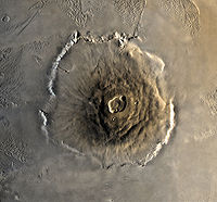
- Olympus MonsOlympus MonsOlympus Mons is a large volcanic mountain on the planet Mars. At a height of almost , it is one of the tallest mountains in the Solar System, three times as tall as Mount Everest and more than twice the height of Mauna Kea the tallest mountain on Earth. Olympus Mons is the youngest of the large...
- Arsia MonsArsia MonsArsia Mons is the southernmost of three volcanos on the Tharsis bulge near the equator of the planet Mars. To its north is Pavonis Mons, and north of that is Ascraeus Mons. The tallest mountain in the solar system, Olympus Mons, is to its northwest...
- Ascraeus MonsAscraeus MonsAscraeus Mons is a large shield volcano located in the Tharsis region of the planet Mars. It is the northernmost and tallest of three shield volcanoes collectively known as the Tharsis Montes. The volcano's location corresponds to the classical albedo feature Ascraeus Lacus.Ascraeus Mons was...
- Pavonis MonsPavonis MonsPavonis Mons is a large shield volcano located in the Tharsis region of the planet Mars. It is the middle member of a chain of three volcanic mountains that straddle the Martian equator between longitudes 235°E and 259°E. The volcano was discovered by the Mariner 9 spacecraft in 1971 and was...
- Syrtis Major Planum
- Maat MonsMaat MonsMaat Mons is a massive shield volcano and the highest volcano on the planet Venus. It rises above the mean planetary radius at . It is named after the Egyptian goddess of truth and justice, Ma'at.-Structure:...
- Theia MonsTheia MonsTheia Mons is a large shield volcano on Venus named after a great Titaness.LOCATION: Beta RegioELEVATION: about 20,000 ftTYPE: shield volcanoSTAGE: extinctRECENT ERUPTIONS:HISTORICAL ERUPTIONS:MATERIALS FROM ERUPTIONS:VOLCANIC FEATURES: caldera...
Io
Io, a moon of Jupiter, has several Volcanoes that spew Sulphur.Some of these include Pele and Tohil Mons.
Papua New Guinea
- RabaulRabaul calderaRabaul caldera is a large volcano situated in East New Britain, Papua New Guinea. It derives its name from the town of Rabaul situated inside the caldera. The highest of its multiple peaks is ....
, New BritainNew BritainNew Britain, or Niu Briten, is the largest island in the Bismarck Archipelago of Papua New Guinea. It is separated from the island of New Guinea by the Dampier and Vitiaz Straits and from New Ireland by St. George's Channel... - Billy MitchellBilly Mitchell (volcano)Billy Mitchell is a volcano located in the central part of the island of Bougainville, just northeast of the Bagana Volcano, in Papua New Guinea. It is a small, pyroclastic shield truncated by a 2 km wide caldera filled by a crater lake....
, BougainvilleBougainville IslandBougainville Island is the main island of the Autonomous Region of Bougainville of Papua New Guinea. This region is also known as Bougainville Province or the North Solomons. The population of the province is 175,160 , which includes the adjacent island of Buka and assorted outlying islands... - LoloruLoloruLoloru is a pyroclastic shield volcano located in the southern part of the island of Bougainville, Papua New Guinea. The summit consists of two nested calderas, with an andesitic lava dome and a crescent-shaped crater lake.- References :*...
Other
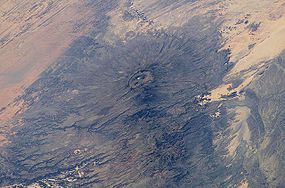
- Emi KoussiEmi KoussiEmi Koussi is a high pyroclastic shield volcano that lies at the south end of the Tibesti Mountains in the central Sahara of northern Chad. It is the highest mountain in Chad, and the highest in the Sahara. The volcano is one of several in the Tibesti massif, and reaches 3445 m in altitude,...
, ChadChadChad , officially known as the Republic of Chad, is a landlocked country in Central Africa. It is bordered by Libya to the north, Sudan to the east, the Central African Republic to the south, Cameroon and Nigeria to the southwest, and Niger to the west... - AmbrymAmbrymAmbrym is a volcanic island in the archipelago of Vanuatu . It is well known for its highly active volcanic activity that includes lava lake formation.-Etymology:...
, VanuatuVanuatuVanuatu , officially the Republic of Vanuatu , is an island nation located in the South Pacific Ocean. The archipelago, which is of volcanic origin, is some east of northern Australia, northeast of New Caledonia, west of Fiji, and southeast of the Solomon Islands, near New Guinea.Vanuatu was... - ApoyequeApoyequeApoyeque is a pyroclastic shield, located in the Chiltepe Peninsula Natural Reserve in Nicaragua. It has a 2.8-km wide, 400-m-deep, lake-filled caldera.-Geography:Apoyeque is a volcanic complex that formed and occuplies the Chiltepe Peninsula...
, NicaraguaNicaraguaNicaragua is the largest country in the Central American American isthmus, bordered by Honduras to the north and Costa Rica to the south. The country is situated between 11 and 14 degrees north of the Equator in the Northern Hemisphere, which places it entirely within the tropics. The Pacific Ocean... - Purico ComplexPurico ComplexThe Purico Complex is a pyroclastic shield located in the eastern part of the Atacama desert in Chile's II Region , approximately south of the Bolivia - Chile border...
, ChileChileChile ,officially the Republic of Chile , is a country in South America occupying a long, narrow coastal strip between the Andes mountains to the east and the Pacific Ocean to the west. It borders Peru to the north, Bolivia to the northeast, Argentina to the east, and the Drake Passage in the far...
See also
- List of stratovolcanoes
- List of subglacial volcanoes
- List of cinder cones
- List of lava domes
- Shield volcanoShield volcanoA shield volcano is a type of volcano usually built almost entirely of fluid lava flows. They are named for their large size and low profile, resembling a warrior's shield. This is caused by the highly fluid lava they erupt, which travels farther than lava erupted from more explosive volcanoes...
- List of currently erupting volcanoes