
Mount Overlord
Encyclopedia
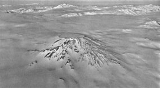
Mount Overlord is a very large mountain
which is an extinct stratovolcano
, situated at the northwest limit of Deception Plateau
, 50 miles inland from the Ross Sea
and just east of the head of Aviator Glacier
in Victoria Land
. Its assymetrial cone is on the edge of a plateau above Aviator Glacier
. While most of the cone is ice-covered, Mount Overlord does have a 1.2-mile (.8 kilometer) diameter caldera. Volcanic rocks from the western slope have been dated to about seven million years, so the volcano is thought to be extinct. It was so named by the northern party of New Zealand Geological Survey Antarctic Expedition
(NZGSAE), 1962–63, because it "overlords" lesser peaks in the area.

Mountain
Image:Himalaya_annotated.jpg|thumb|right|The Himalayan mountain range with Mount Everestrect 58 14 160 49 Chomo Lonzorect 200 28 335 52 Makalurect 378 24 566 45 Mount Everestrect 188 581 920 656 Tibetan Plateaurect 250 406 340 427 Rong River...
which is an extinct stratovolcano
Stratovolcano
A stratovolcano, also known as a composite volcano, is a tall, conical volcano built up by many layers of hardened lava, tephra, pumice, and volcanic ash. Unlike shield volcanoes, stratovolcanoes are characterized by a steep profile and periodic, explosive eruptions...
, situated at the northwest limit of Deception Plateau
Deception Plateau
Deception Plateau is a high, ice-covered plateau, 11 miles long and 6 miles wide, which is bounded by Aviator Glacier, Pilot Glacier and Mount Overlord, in Victoria Land. So named by the southern party of New Zealand Geological Survey Antarctic Expedition , 1966–67, because of its deceptively...
, 50 miles inland from the Ross Sea
Ross Sea
The Ross Sea is a deep bay of the Southern Ocean in Antarctica between Victoria Land and Marie Byrd Land.-Description:The Ross Sea was discovered by James Ross in 1841. In the west of the Ross Sea is Ross Island with the Mt. Erebus volcano, in the east Roosevelt Island. The southern part is covered...
and just east of the head of Aviator Glacier
Aviator Glacier
Aviator Glacier is major valley glacier, over 60 miles long and 5 miles wide, descending generally southward from the plateau of Victoria Land along the west side of Mountaineer Range, and entering Lady Newnes Bay between Cape Sibbald and Hayes Head where it forms the Aviator Glacier Tongue...
in Victoria Land
Victoria Land
Victoria Land is a region of Antarctica bounded on the east by the Ross Ice Shelf and the Ross Sea and on the west by Oates Land and Wilkes Land. It was discovered by Captain James Clark Ross in January 1841 and named after the UK's Queen Victoria...
. Its assymetrial cone is on the edge of a plateau above Aviator Glacier
Aviator Glacier
Aviator Glacier is major valley glacier, over 60 miles long and 5 miles wide, descending generally southward from the plateau of Victoria Land along the west side of Mountaineer Range, and entering Lady Newnes Bay between Cape Sibbald and Hayes Head where it forms the Aviator Glacier Tongue...
. While most of the cone is ice-covered, Mount Overlord does have a 1.2-mile (.8 kilometer) diameter caldera. Volcanic rocks from the western slope have been dated to about seven million years, so the volcano is thought to be extinct. It was so named by the northern party of New Zealand Geological Survey Antarctic Expedition
New Zealand Geological Survey Antarctic Expedition
The New Zealand Geological Survey Antarctic Expedition describes a series of scientific explorations of the continent Antarctica. The expeditions were notably active in 1957-58 and again in 1958-59. The 1957-58 expedition went to the Ross Dependency and named the Borchgrevink Glacier...
(NZGSAE), 1962–63, because it "overlords" lesser peaks in the area.