
Augustine Volcano
Encyclopedia
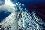
Augustine Volcano is a Lava Dome
Complex on Augustine Island in southwestern Cook Inlet
in the Kenai Peninsula Borough
of southcentral coastal Alaska
, 280 kilometres (174 mi) southwest of Anchorage
. The Alaska Volcano Observatory
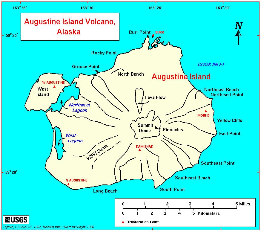
currently rates Mount Augustine as Level of Concern Color Code Green for aviation and the Volcano Alert Level is at Normal. Augustine Island has a land area of 83.872 square kilometres (32.4 sq mi), while West Island, just off Augustine's western shores, has 5.142 km² (2 sq mi).
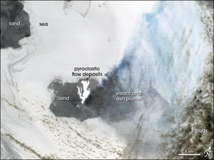
The island is made up mainly of past eruption deposits. Scientists have been able to discern that past dome collapse has resulted in large avalanche
s.
 Augustine's summit consists of several overlapping lava dome
complex
es placed during many historic and prehistoric eruptions. Most of the fragmental debris exposed along its slopes comprises angular blocks of dome-rock andesite
, typically of cobble to boulder size but carrying clasts as large as 4 to 8 meters (10 to 25 feet), rarely as large as 30 meters (100 ft). The surface of such deposits is skeet, a field of steep conical mounds and intervening depressions with many meters of local relief. En route to Katmai
in 1913, Robert F. Griggs
had briefly inferred landslide (debris avalanche) as the origin of Augustine's hummocky coastal topography about Burr Point
, by geomorphic analogy with the hummocky and blocky deposit of a 1912 landslide near Katmai
.
The hummocky deposits on Augustine's lower flanks resemble both topographically and lithologically those of the great landslide or debris avalanche that initiated the spectacular May 18, 1980 eruption of Mount St. Helens
. The deposit of that landslide revealed the origin of coarse diamicts with hummocky topography at other strato volcanic cones. Since 1980 many hummocky coarsely fragmental deposits on Augustine's lower flanks have come to be interpreted as deposits of numerous great landslides and debris avalanches.
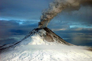
 A March 27, 1986 eruption deposited ash over Anchorage and disrupted air traffic in southcentral Alaska.
On January 11, 1994, Augustine erupted at 13:44 and 14:13 UTC.
-laden plume of steam, hundreds of miniature earthquakes and a new coating of ash over its currently snow-clad peak, taken together, suggested that Augustine was building to a new eruption, likely in 2006. The eruption consisted of four "phases", continuing from December to March 2006.
The initial stage of the eruption began when microearthquake
activity increased steadily from May to December 2005. At first, they started out at around 2 each day to around 15 each day. Microearthquakes are tiny earthquake that suggest a volcanic eruption could possibly occur.
The volcano erupted on January 11, entering a second "stage", which would continue until January 28. Tectonic earthquakes began early on January, resulting in an explosive Volcanic Explosivity Index
3 eruption later in the day. Several ash columns were generated, each 9 km (6 mi) above sea level
; these plumes were steadily influenced to the north and northeast of the volcano. Samples of the tephra
were dense, insinuating that the lava
released was mature.
Six explosions were recorded by seismic instruments between January 13, the first of these consuming a seismograph and a CPGS located on the northwestern flank. Ash columns now reached 14 km (9 mi) and Kenai Peninsula
residents reported ash deposits. On January 16, a new lava dome was observed on the summit; and the next day another explosive eruption sent ash 13 km (8 mi) into the atmosphere. This explosion created a 20-30 meter wide crater in the new lava dome.
 On September 22, 2007, the Alaska Volcano Observatory
reported that shallow earthquake activity had increased over the week of September 22. However, the activity was less than its level during the months leading up to the 2005-2006 eruption.
Lava dome
|250px|thumb|right|Image of the [[rhyolitic]] lava dome of [[Chaitén Volcano]] during its 2008–2009 eruption.In volcanology, a lava dome is a roughly circular mound-shaped protrusion resulting from the slow extrusion of viscous lava from a volcano...
Complex on Augustine Island in southwestern Cook Inlet
Cook Inlet
Cook Inlet stretches from the Gulf of Alaska to Anchorage in south-central Alaska. Cook Inlet branches into the Knik Arm and Turnagain Arm at its northern end, almost surrounding Anchorage....
in the Kenai Peninsula Borough
Kenai Peninsula Borough, Alaska
-National protected areas:* Alaska Maritime National Wildlife Refuge ** Chiswell Islands** Tuxedni Wilderness* Chugach National Forest * Katmai National Park and Preserve ** Katmai Wilderness...
of southcentral coastal Alaska
Alaska
Alaska is the largest state in the United States by area. It is situated in the northwest extremity of the North American continent, with Canada to the east, the Arctic Ocean to the north, and the Pacific Ocean to the west and south, with Russia further west across the Bering Strait...
, 280 kilometres (174 mi) southwest of Anchorage
Anchorage, Alaska
Anchorage is a unified home rule municipality in the southcentral part of the U.S. state of Alaska. It is the northernmost major city in the United States...
. The Alaska Volcano Observatory
Alaska Volcano Observatory
The Alaska Volcano Observatory is a joint program of the United States Geological Survey, the Geophysical Institute of the University of Alaska Fairbanks, and the State of Alaska Division of Geological and Geophysical Surveys...
currently rates Mount Augustine as Level of Concern Color Code Green for aviation and the Volcano Alert Level is at Normal. Augustine Island has a land area of 83.872 square kilometres (32.4 sq mi), while West Island, just off Augustine's western shores, has 5.142 km² (2 sq mi).
The island is made up mainly of past eruption deposits. Scientists have been able to discern that past dome collapse has resulted in large avalanche
Avalanche
An avalanche is a sudden rapid flow of snow down a slope, occurring when either natural triggers or human activity causes a critical escalating transition from the slow equilibrium evolution of the snow pack. Typically occurring in mountainous terrain, an avalanche can mix air and water with the...
s.
Description and geologic history
The nearly circular uninhabited island formed by Augustine Volcano is 12 km (7.5 mi) wide east-west, 10 km (6 mi) north-south; a nearly symmetrical central summit peaks at altitude 4134 feet (1,260 m).Lava dome
|250px|thumb|right|Image of the [[rhyolitic]] lava dome of [[Chaitén Volcano]] during its 2008–2009 eruption.In volcanology, a lava dome is a roughly circular mound-shaped protrusion resulting from the slow extrusion of viscous lava from a volcano...
complex
Complex volcano
A complex volcano, also called a compound volcano, is a volcano with more than one feature. They form because changes of their eruptive characteristics or the location of multiple vents in an area...
es placed during many historic and prehistoric eruptions. Most of the fragmental debris exposed along its slopes comprises angular blocks of dome-rock andesite
Andesite
Andesite is an extrusive igneous, volcanic rock, of intermediate composition, with aphanitic to porphyritic texture. In a general sense, it is the intermediate type between basalt and dacite. The mineral assemblage is typically dominated by plagioclase plus pyroxene and/or hornblende. Magnetite,...
, typically of cobble to boulder size but carrying clasts as large as 4 to 8 meters (10 to 25 feet), rarely as large as 30 meters (100 ft). The surface of such deposits is skeet, a field of steep conical mounds and intervening depressions with many meters of local relief. En route to Katmai
Mount Katmai
Mount Katmai is a large stratovolcano on the Alaska Peninsula in southern Alaska, located within Katmai National Park and Preserve. It is about in diameter with a central lake-filled caldera about 3 by 2 mi in area, formed during the Novarupta eruption of 1912. The caldera rim reaches a...
in 1913, Robert F. Griggs
Robert F Griggs
Robert Fiske Griggs, , was a botanist who led a 1915 National Geographic Society expedition to observe the aftermath of the Katmai volcanic eruption....
had briefly inferred landslide (debris avalanche) as the origin of Augustine's hummocky coastal topography about Burr Point
Burr Point
Burr Point is the easternmost point of mainland Northern Ireland, and the easternmost point of mainland Ireland. It is located in the townland of Ballyhalbert on the Ards Peninsula in County Down, at longitude 5.43ºW...
, by geomorphic analogy with the hummocky and blocky deposit of a 1912 landslide near Katmai
Mount Katmai
Mount Katmai is a large stratovolcano on the Alaska Peninsula in southern Alaska, located within Katmai National Park and Preserve. It is about in diameter with a central lake-filled caldera about 3 by 2 mi in area, formed during the Novarupta eruption of 1912. The caldera rim reaches a...
.
The hummocky deposits on Augustine's lower flanks resemble both topographically and lithologically those of the great landslide or debris avalanche that initiated the spectacular May 18, 1980 eruption of Mount St. Helens
Mount St. Helens
Mount St. Helens is an active stratovolcano located in Skamania County, Washington, in the Pacific Northwest region of the United States. It is south of Seattle, Washington and northeast of Portland, Oregon. Mount St. Helens takes its English name from the British diplomat Lord St Helens, a...
. The deposit of that landslide revealed the origin of coarse diamicts with hummocky topography at other strato volcanic cones. Since 1980 many hummocky coarsely fragmental deposits on Augustine's lower flanks have come to be interpreted as deposits of numerous great landslides and debris avalanches.
Eruptive activity
On January 11, 1994, Augustine erupted at 13:44 and 14:13 UTC.
2006
In mid-December 2005 a sulfur dioxideSulfur dioxide
Sulfur dioxide is the chemical compound with the formula . It is released by volcanoes and in various industrial processes. Since coal and petroleum often contain sulfur compounds, their combustion generates sulfur dioxide unless the sulfur compounds are removed before burning the fuel...
-laden plume of steam, hundreds of miniature earthquakes and a new coating of ash over its currently snow-clad peak, taken together, suggested that Augustine was building to a new eruption, likely in 2006. The eruption consisted of four "phases", continuing from December to March 2006.
The initial stage of the eruption began when microearthquake
Microearthquake
A microearthquake is a very low intensity earthquake which is usually three or less on the Richter scale. In addition to having natural tectontic causes, they may also be seen as a result of underground nuclear testing or even large detonations of conventional explosives for producing excavations...
activity increased steadily from May to December 2005. At first, they started out at around 2 each day to around 15 each day. Microearthquakes are tiny earthquake that suggest a volcanic eruption could possibly occur.
The volcano erupted on January 11, entering a second "stage", which would continue until January 28. Tectonic earthquakes began early on January, resulting in an explosive Volcanic Explosivity Index
Volcanic Explosivity Index
The Volcanic Explosivity Index was devised by Chris Newhall of the U.S. Geological Survey and Stephen Self at the University of Hawaii in 1982 to provide a relative measure of the explosiveness of volcanic eruptions....
3 eruption later in the day. Several ash columns were generated, each 9 km (6 mi) above sea level
Sea level
Mean sea level is a measure of the average height of the ocean's surface ; used as a standard in reckoning land elevation...
; these plumes were steadily influenced to the north and northeast of the volcano. Samples of the tephra
Tephra
200px|thumb|right|Tephra horizons in south-central [[Iceland]]. The thick and light coloured layer at center of the photo is [[rhyolitic]] tephra from [[Hekla]]....
were dense, insinuating that the lava
Lava
Lava refers both to molten rock expelled by a volcano during an eruption and the resulting rock after solidification and cooling. This molten rock is formed in the interior of some planets, including Earth, and some of their satellites. When first erupted from a volcanic vent, lava is a liquid at...
released was mature.
Six explosions were recorded by seismic instruments between January 13, the first of these consuming a seismograph and a CPGS located on the northwestern flank. Ash columns now reached 14 km (9 mi) and Kenai Peninsula
Kenai Peninsula
The Kenai Peninsula is a large peninsula jutting from the southern coast of Alaska in the United States. The name Kenai is probably derived from Kenayskaya, the Russian name for Cook Inlet, which borders the peninsula to the west.-Geography:...
residents reported ash deposits. On January 16, a new lava dome was observed on the summit; and the next day another explosive eruption sent ash 13 km (8 mi) into the atmosphere. This explosion created a 20-30 meter wide crater in the new lava dome.
Alaska Volcano Observatory
The Alaska Volcano Observatory is a joint program of the United States Geological Survey, the Geophysical Institute of the University of Alaska Fairbanks, and the State of Alaska Division of Geological and Geophysical Surveys...
reported that shallow earthquake activity had increased over the week of September 22. However, the activity was less than its level during the months leading up to the 2005-2006 eruption.