
Tongariro National Park
Encyclopedia
Tongariro National Park is the oldest national park
in New Zealand
, located in the central North Island
. It has been acknowledged by UNESCO
as one of the 28 mixed cultural and natural World Heritage Sites.
Tongariro National Park was the fourth national park established in the world. The active volcanic
mountain
s Ruapehu
, Ngauruhoe
, and Tongariro
are located in the centre of the park.
There are a number of Māori religious sites within the park and the summits of Tongariro, including Ngauruhoe and Ruapehu, are tapu (sacred). The park includes many towns around its boundary including Ohakune
, Waiouru
, Horopito
, Pokaka
, Erua, National Park Village, Whakapapa skifield
and Turangi
.
. It is 330 km south of Auckland
by road, and 320 km north of Wellington
. It contains a considerable part of the North Island Volcanic Plateau
. Directly to the east stand the hills of the Kaimanawa range
. The Whanganui River
rises within the park and flows through Whanganui National Park
to the west.
Most of the park is located in the Ruapehu District
(Manawatu-Wanganui Region), although the northeast is in the Taupo District
(Waikato Region, or Hawke's Bay Region to the north).
As a curiosity, their exact antipodes coincide with Cabañeros National Park
, in Spain.
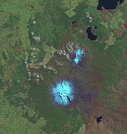 Tongariro National Park stretches around the massif of the three volcanoes Mount Ruapehu
, Mount Ngauruhoe
, and Mount Tongariro
. The Pihanga Scenic Reserve, containing Lake Rotopounamu, Mount Pihanga and Mount Kakaramea, though outside the main park area, is part of the park.
On the park borders are the towns of Turangi
, National Park Village
and Ohakune
. Further away are Waiouru
and Raetihi
. Within the park borders, the only settlements are the tourism-based village at Whakapapa Village
which consists solely of ski accommodation. Two Maori kainga (settlements) Papakai and Otukou are not part of the park but lie on the shores of Lake Rotoaira
between the Pihanga Scenic Reserve
and the main park area.
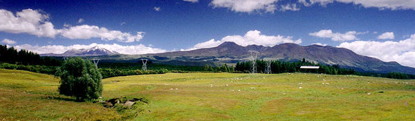
Tongariro National Park is surrounded by well-maintained roads that roughly follow the park borders and provide easy access. In the west, State Highway 4 passes National Park village, and in the east, State Highway 1
, known for this stretch as the Desert Road, runs parallel to the Tongariro River. State Highway 47 joins these two highways to the north. The southern link is State Highway 49. The North Island Main Trunk railway from Auckland
to Wellington
passes National Park village.
. The prevailing westerly winds gather water over the Tasman Sea
. As the volcanoes of Tongariro National Park are the first significant elevations that these winds encounter on the North Island, besides Mount Taranaki
, rain falls almost daily. The east-west rainfall differences are not as great as in the Southern Alps
, because the three volcanoes do not belong to a greater mountain range, but there is still a noticeable rain shadow effect with the Rangipo desert on the Eastern leeward side receiving 1,000mm rain PA . At Whakapapa
Village (1119m) the average annual rainfall is about 2200 mm, in Ohakune
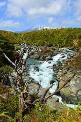
(610m) about 1250 mm and in higher altitudes, such as Iwikau Village (1770m), about 4900 mm. In winter there is snow to about 1500 m. Temperatures vary dramatically, even within one day. In Whakapapa, they can fall below the freezing point all year round. The average temperature is 13 °C, with a maximum of 25 °C in summer and a minimum of -10 °C in winter. In some summers the summits of the three volcanoes are covered with snow; on top of Mount Ruapehu, snow fields can be found every summer and the summit is glaciated.
 The mountain summits are of great significance to the local Māori.
In 1886 in order to prevent exploitation of the mountains by European settlers, the local Ngati Tuwharetoa
iwi had the mountains surveyed in the Native Land Court and then set aside (whakatapua) as a reserve in the names of certain chiefs one of whom was Te Heuheu Tukino IV
(Horonuku), the most significant chief of the Māori Ngati Tuwharetoa
iwi
.
Later the peaks of Mount Tongariro
, Mount Ngauruhoe, and parts of Mount Ruapehu, were conveyed to The Crown
on 23 September 1887, on condition that a protected area was established there.
This 26.4 km² area was generally considered to be too small to establish a national park after the model of Yellowstone National Park
in Wyoming
(USA), and so further areas were acquired. When the New Zealand Parliament passed the Tongariro National Park Act in October 1894, the park covered an area of about 252.13 km², but it took until 1907 to acquire the land. When the Act was renewed in 1922, the park area was extended to 586.8 km². Further extensions, especially Pihanga Scenic Reserve in 1975, enlarged the park to its current size of 795.98 km². The last modification to the Act was passed in 1980. Tongariro National Park has been under the control of the New Zealand Department of Conservation
since the creation of the department in 1987.
The first activities in the young Tongariro National Park were the construction of tourist huts at the beginning of the 20th century. But it was not before opening of the railway in 1908 and the building of roads in the 1930s that a significant number of people visited the park. The second Tongariro National Park Act, in 1922, started some active conservation efforts, but it was not until 1931 that the first permanent park ranger began work. Road construction into Whakapapa valley had already begun in the 1920s. The first ski hut was built in 1923 at an elevation of 1770 m, thereafter a road, and, in 1938, a ski lift in the area. This early tourist development explains the rather uncommon existence of a permanently inhabited village and fully developed ski area within a national park. The hotel Chateau Tongariro
, which is still the centre of Whakapapa today, was established in 1929.
In the early 20th century, park administrators introduced heather
to the park, for grouse
hunting. Grouse were never actually introduced, but the heather is sprawling, threatening the ecological system and endemic plants of the park. Efforts are being made to control the plant's spread, however complete eradication seems unlikely.
The western diversion takes water from six rivers and streams from the Whakapapa River to the Whanganui River, into Lake Rotoaira via Lake Otamangakau. The Tokaanu power station is connected to Lake Rotoaira via a six kilometre tunnel through Mount Tihia. It also draws water from the Tongariro River via the Poutu tunnel and canal.
On the eastern side of Mount Ruapehu, water is diverted from the Kaimanawa Ranges and headwaters of the Wahianoa River through a 20 km tunnel into the Rangipo dam. The 120MW Rangipo power station is 230 m below ground. Its turbines are located in a cavern cut from solid rock and lined with concrete. Genesis Energy has developed mitigation measures with stakeholders that aim to lessen the environmental effects of the Tongariro Power Scheme.
Some of these measures include lake level management, ecological monitoring programmes, and agreements with local iwi to establish a process for iwi involvement in environmental monitoring and access to information. The electricity generated at the Tongariro Power Scheme goes into the national grid. Then it is distributed to residential, commercial and industrial customers throughout New Zealand.
meets the Pacific Plate
.These volcanoes have resulted from internal tectonic processes. The Pacific Plate subducts under the Indo-Australian plate, and subsequently melts due to the high temperatures of the aesthenosphere. This magma being less dense, rises to the surface and goes through the weak parts of the Earth's crust(the faults) resulting in volcanic processes in the area. Volcanic processes have been causing the uplift of the mountains of Tongariro National Park for over two million years.
stretches over an area of 30 km², and up to an elevation of 1000 m. In this rain forest live Hall's totara (Podocarpus hallii), kahikatea (Dacrycarpus dacrydioides), kamahi (Weinmannia racemosa
), pahautea (Libocedrus bidwillii
), and numerous epiphytic
fern
s, orchids
, and fungi
. Pahautea trees can be found further on up to a height of 1530 m, where they cover 127.3 km². On this level, one can also find a 50 km² beech forest, containing red (Nothofagus fusca), silver (Nothofagus menziesii) and mountain beech (Nothofagus solandri var cliffortioides). Understory species within the forests include ferns such as Crown Fern, Blechnum discolor
as well as shrub species. There is also a 95 km² area of scrubland, containing kanuka (Leptospermum ericoides), manuka
(Leptospermum scoparium), celery-top pine (Phyllocladus aspleniifolius
), inaka (Dracophyllum longifolium), woolly fringe moss (Rhacomitrium lanuginosum), small beeches and introduced heather. To the northwest, and around Mount Ruapehu, between an altitude of 1200 and 1500 m, tussock
shrubland
and tussock grass covers large areas (around 150 km²), consisting mainly of New Zealand red tussock grass (Chionochloa rubra
), inaka, curled leaved neinei (Dracophyllum recurvum
), wire rush (Empodisma minus), and bog rush (Schoenus pauciflorus), as well as heather and grasses like hard tussock (Festuca novaezelandiae) and bluegrass (Poa colensoi). Above 1500 m, the terrain consists of gravel and stone fields and is accordingly unstable. Nevertheless, some plants occasionally settle there, such as curled leaved neinei, snow totara (Podocarpus nivalis
), mountain snowberry (Gaultheria colensoi), bristle tussock (Rytidosperma setifolium), bluegrass and Raoulia albosericea, which cover an area of 165 km². Between 1700 and 2020 m there are some isolated Parahebe species, Gentiana gellidifolia and buttercups. Above 2200 m live only crustose lichen
s.
, kākā
, blue duck
, North Island fernbird (Bowdleria punctata vealeae), double-banded plover (Charadrius bicinctus) and karearea
. Other bird species common to the park are tui
, New Zealand bellbird
, southern boobook
, grey warbler (Gerygone igata), fantail
, and silvereye
.
The park also features the only two native mammals of New Zealand, the short and long tailed bat (Mystacina tuberculata and Chalinolobus tuberculatus). The Tongariro National Park also teems with insects like moth
s and weta
s. Also present in the park, as well as the whole of New Zealand, are animals introduced by Europeans, such as black rat
s, stoat
s, cat
s, rabbit
s, hare
, possum
s and red deer
.
 The main activities are hiking
and climbing
in summer, and skiing
and snowboarding
in winter. There is also opportunity for hunting
, game fishing, mountain biking
, horse riding, rafting
and scenic flights.
Mount Tongariro
and its surroundings are one of the several locations where Peter Jackson
shot the The Lord of the Rings film trilogy
; tours to view these places are commonly arranged by the tour's operators and lodges.
The most popular track in Tongariro National Park is the Tongariro Alpine Crossing. Most of the track is also part of the Tongariro Northern Circuit
, a two to four day tour, which is one of New Zealand's nine Great Walks
. Side trips to the summits of Mount Tongariro
and Mount Ngauruhoe are possible on these tracks. Another route is the three to six day Round the Mountain Track around Mount Ruapehu. Besides these, there are numerous shorter tracks appropriate for day tramps. With this track net, three camp sites, two emergency shelters, nine public and four private huts and the facilities in Whakapapa, the park is well developed for tourism. These tracks also serve as winter routes, as well as the track to the summit of Mount Ruapehu. Rock-climbing is also an option.
Snow season is from late June to early November. The biggest ski area, also called Whakapapa
, is on the north-western slopes of Mount Ruapehu. It has 15 lifts, covering an area of 5.5 km². Directly next to the ski field are 47 ski club huts; most of them also accommodate non-club members. The next settlement is on the bottom, in Whakapapa. A slightly smaller ski field called Turoa
is on the south-western slope. Though it has only nine lifts, the skiing area, of 5 km², is almost as large as Whakapapa's. There is no accommodation at the ski field; the nearest town is Ohakune. These two ski fields came under common management in 2000. Ski passes can be used on both fields, and a lift or run from one field to the other is planned. Beside these major ski fields, there are also the Tukino ski area
, privately run by the Desert Alpine Ski Club, and the Aorangi Ski Club on the south-eastern slope. It has two nutcracker rope tows, and covers 1.9 km².
National park
A national park is a reserve of natural, semi-natural, or developed land that a sovereign state declares or owns. Although individual nations designate their own national parks differently A national park is a reserve of natural, semi-natural, or developed land that a sovereign state declares or...
in New Zealand
New Zealand
New Zealand is an island country in the south-western Pacific Ocean comprising two main landmasses and numerous smaller islands. The country is situated some east of Australia across the Tasman Sea, and roughly south of the Pacific island nations of New Caledonia, Fiji, and Tonga...
, located in the central North Island
North Island
The North Island is one of the two main islands of New Zealand, separated from the much less populous South Island by Cook Strait. The island is in area, making it the world's 14th-largest island...
. It has been acknowledged by UNESCO
UNESCO
The United Nations Educational, Scientific and Cultural Organization is a specialized agency of the United Nations...
as one of the 28 mixed cultural and natural World Heritage Sites.
Tongariro National Park was the fourth national park established in the world. The active volcanic
Volcano
2. Bedrock3. Conduit 4. Base5. Sill6. Dike7. Layers of ash emitted by the volcano8. Flank| 9. Layers of lava emitted by the volcano10. Throat11. Parasitic cone12. Lava flow13. Vent14. Crater15...
mountain
Mountain
Image:Himalaya_annotated.jpg|thumb|right|The Himalayan mountain range with Mount Everestrect 58 14 160 49 Chomo Lonzorect 200 28 335 52 Makalurect 378 24 566 45 Mount Everestrect 188 581 920 656 Tibetan Plateaurect 250 406 340 427 Rong River...
s Ruapehu
Mount Ruapehu
Mount Ruapehu, or just Ruapehu, is an active stratovolcano at the southern end of the Taupo Volcanic Zone in New Zealand. It is 23 kilometres northeast of Ohakune and 40 kilometres southwest of the southern shore of Lake Taupo, within Tongariro National Park...
, Ngauruhoe
Mount Ngauruhoe
Mount Ngauruhoe is an active stratovolcano or composite cone in New Zealand, made from layers of lava and tephra. It is the youngest vent in the Tongariro volcanic complex on the Central Plateau of the North Island, and first erupted about 2,500 years ago...
, and Tongariro
Mount Tongariro
Mount Tongariro is a volcanic complex in the North Island of New Zealand. It is located 20 kilometres to the southwest of Lake Taupo, and is the northernmost of the three active volcanoes that dominate the landscape of the central North Island....
are located in the centre of the park.
There are a number of Māori religious sites within the park and the summits of Tongariro, including Ngauruhoe and Ruapehu, are tapu (sacred). The park includes many towns around its boundary including Ohakune
Ohakune
Ohakune is a town in the North Island of New Zealand. It is located at the southern end of the Tongariro National Park, close to the southwestern slopes of the active volcano Mount Ruapehu. Part of the Manawatu-Wanganui region, the town is 70 kilometres northeast of Wanganui, and 25 kilometres west...
, Waiouru
Waiouru
Waiouru is a small town in the centre of the North Island of New Zealand. It is on the North Island Volcanic Plateau, 25 kilometres south-east of Mount Ruapehu, and in the Ruapehu District....
, Horopito
Horopito, New Zealand
Horopito is a locality in the North Island of New Zealand.It lies on State Highway 4 between the village of National Park and the town of Raetihi.Horopito was the setting for the 1981 New Zealand feature film Smash Palace...
, Pokaka
Pokaka
Pokaka is a locality south of National Park Village in Ruapehu District, Manawatu-Wanganui Region, the Central North Island of New Zealand.Pokaka is located inside the Tongariro National Park....
, Erua, National Park Village, Whakapapa skifield
Whakapapa skifield
Whakapapa, on the northern side of Mount Ruapehu in New Zealand's Tongariro National Park, is one of the mountain's two commercial skifields. The other is Turoa, located on the mountain's south-western slopes...
and Turangi
Turangi
Turangi is a small town on the west bank of the Tongariro River, 50 kilometres south-west of Taupo on the North Island Volcanic Plateau of New Zealand. It was built to accommodate the workers associated with the Tongariro hydro-electric power development project and their families...
.
Location
Tongariro National Park covers approximately 795.98 km² stretching between 175° 22' and 175° 48' East and 38° 58' and 39° 25' South in the heart of the North Island of New Zealand. It is just a few kilometres west-southwest of Lake TaupoLake Taupo
Lake Taupo is a lake situated in the North Island of New Zealand. With a surface area of , it is the largest lake by surface area in New Zealand, and the second largest freshwater lake by surface area in geopolitical Oceania after Lake Murray ....
. It is 330 km south of Auckland
Auckland
The Auckland metropolitan area , in the North Island of New Zealand, is the largest and most populous urban area in the country with residents, percent of the country's population. Auckland also has the largest Polynesian population of any city in the world...
by road, and 320 km north of Wellington
Wellington
Wellington is the capital city and third most populous urban area of New Zealand, although it is likely to have surpassed Christchurch due to the exodus following the Canterbury Earthquake. It is at the southwestern tip of the North Island, between Cook Strait and the Rimutaka Range...
. It contains a considerable part of the North Island Volcanic Plateau
North Island Volcanic Plateau
The North Island Volcanic Plateau is a volcanic plateau covering much of central North Island of New Zealand with volcanoes, lava plateaus, and crater lakes....
. Directly to the east stand the hills of the Kaimanawa range
Kaimanawa Range
The Kaimanawa Range of mountains is located in the central North Island of New Zealand. They extend for 50 kilometres in a northeast/southwest direction through largely uninhabited country to the south of Lake Taupo, east of the "Desert Road"...
. The Whanganui River
Whanganui River
The Whanganui River is a major river in the North Island of New Zealand.Known for many years as the Wanganui River, the river's name reverted to Whanganui in 1991, according with the wishes of local iwi. Part of the reason was also to avoid confusion with the Wanganui River in the South Island...
rises within the park and flows through Whanganui National Park
Whanganui National Park
The Whanganui National Park is a national park located in the North Island of New Zealand. Established in 1986, it covers an area of 742 km² bordering the Whanganui River. It incorporates areas of Crown land, former state forest and a number of former reserves. The river itself is not part of the...
to the west.
Most of the park is located in the Ruapehu District
Ruapehu District
Ruapehu District is a territorial authority near the centre of New Zealand's North Island.It has an area of 6,730.185 square kilometers and a population of 13,569 at the 2006 census .-Features:...
(Manawatu-Wanganui Region), although the northeast is in the Taupo District
Taupo District
The Taupo District covers 6,350 km² of land, as well as a further 610 km² of lake area, both in Lake Taupo, New Zealand's largest lake, and also in the smaller Lake Rotoaira. The district stretches from the small town of Mangakino in the northwest to the Tongariro National Park in the...
(Waikato Region, or Hawke's Bay Region to the north).
As a curiosity, their exact antipodes coincide with Cabañeros National Park
Cabañeros National Park
Cabañeros National Park is a national park in Spain, which falls within two provinces, the northwest of Ciudad Real and the southwest of Toledo.The Park was designated in 1995 and has an area of...
, in Spain.
Dimension
Mount Ruapehu
Mount Ruapehu, or just Ruapehu, is an active stratovolcano at the southern end of the Taupo Volcanic Zone in New Zealand. It is 23 kilometres northeast of Ohakune and 40 kilometres southwest of the southern shore of Lake Taupo, within Tongariro National Park...
, Mount Ngauruhoe
Mount Ngauruhoe
Mount Ngauruhoe is an active stratovolcano or composite cone in New Zealand, made from layers of lava and tephra. It is the youngest vent in the Tongariro volcanic complex on the Central Plateau of the North Island, and first erupted about 2,500 years ago...
, and Mount Tongariro
Mount Tongariro
Mount Tongariro is a volcanic complex in the North Island of New Zealand. It is located 20 kilometres to the southwest of Lake Taupo, and is the northernmost of the three active volcanoes that dominate the landscape of the central North Island....
. The Pihanga Scenic Reserve, containing Lake Rotopounamu, Mount Pihanga and Mount Kakaramea, though outside the main park area, is part of the park.
On the park borders are the towns of Turangi
Turangi
Turangi is a small town on the west bank of the Tongariro River, 50 kilometres south-west of Taupo on the North Island Volcanic Plateau of New Zealand. It was built to accommodate the workers associated with the Tongariro hydro-electric power development project and their families...
, National Park Village
National Park, New Zealand
National Park is a small town on the central plateau of the North Island of New Zealand. Also known as National Park Village it is the highest urban township in New Zealand at 825 metres. As the name suggests, it borders the World Heritage Tongariro National Park, New Zealand's first national...
and Ohakune
Ohakune
Ohakune is a town in the North Island of New Zealand. It is located at the southern end of the Tongariro National Park, close to the southwestern slopes of the active volcano Mount Ruapehu. Part of the Manawatu-Wanganui region, the town is 70 kilometres northeast of Wanganui, and 25 kilometres west...
. Further away are Waiouru
Waiouru
Waiouru is a small town in the centre of the North Island of New Zealand. It is on the North Island Volcanic Plateau, 25 kilometres south-east of Mount Ruapehu, and in the Ruapehu District....
and Raetihi
Raetihi
Raetihi is a town in the central North Island of New Zealand. It is located at the junction of State Highways 4 and 49, 11 kilometres west of Ohakune. The 2006 New Zealand Census of Population and Dwellings recorded its population as 1,035. This constitutes a decrease of 3.4% or 36 people since...
. Within the park borders, the only settlements are the tourism-based village at Whakapapa Village
Whakapapa skifield
Whakapapa, on the northern side of Mount Ruapehu in New Zealand's Tongariro National Park, is one of the mountain's two commercial skifields. The other is Turoa, located on the mountain's south-western slopes...
which consists solely of ski accommodation. Two Maori kainga (settlements) Papakai and Otukou are not part of the park but lie on the shores of Lake Rotoaira
Lake Rotoaira
Lake Rotoaira is a small lake to the south of Lake Taupo on the North Island Volcanic Plateau in New Zealand. It covers an area of 13 km²....
between the Pihanga Scenic Reserve
Pihanga
Mount Pihanga is a 1325m volcanic peak in the North Island Volcanic Plateau, located to the north of Mount Tongariro, between Tongariro and Lake Taupo. Lake Rotoaira lies immediately to the west of Pihanga, and the smaller Lake Rotopounamu is at the north-west foot of the mountain. Mt...
and the main park area.
Tongariro National Park is surrounded by well-maintained roads that roughly follow the park borders and provide easy access. In the west, State Highway 4 passes National Park village, and in the east, State Highway 1
State Highway 1 (New Zealand)
State Highway 1 is the longest and most significant road in the New Zealand roading network, running the length of both main islands. It appears on road maps as SH 1 and on road signs as a white number 1 on a red shield, but it has the official designations SH 1N in the North Island, SH 1S in the...
, known for this stretch as the Desert Road, runs parallel to the Tongariro River. State Highway 47 joins these two highways to the north. The southern link is State Highway 49. The North Island Main Trunk railway from Auckland
Auckland
The Auckland metropolitan area , in the North Island of New Zealand, is the largest and most populous urban area in the country with residents, percent of the country's population. Auckland also has the largest Polynesian population of any city in the world...
to Wellington
Wellington
Wellington is the capital city and third most populous urban area of New Zealand, although it is likely to have surpassed Christchurch due to the exodus following the Canterbury Earthquake. It is at the southwestern tip of the North Island, between Cook Strait and the Rimutaka Range...
passes National Park village.
Climate
Like the whole of New Zealand, Tongariro National Park is situated in a temperate zoneTemperate
In geography, temperate or tepid latitudes of the globe lie between the tropics and the polar circles. The changes in these regions between summer and winter are generally relatively moderate, rather than extreme hot or cold...
. The prevailing westerly winds gather water over the Tasman Sea
Tasman Sea
The Tasman Sea is the large body of water between Australia and New Zealand, approximately across. It extends 2,800 km from north to south. It is a south-western segment of the South Pacific Ocean. The sea was named after the Dutch explorer Abel Janszoon Tasman, the first recorded European...
. As the volcanoes of Tongariro National Park are the first significant elevations that these winds encounter on the North Island, besides Mount Taranaki
Mount Taranaki
Mount Taranaki, or Mount Egmont, is an active but quiescent stratovolcano in the Taranaki region on the west coast of New Zealand's North Island. Although the mountain is more commonly referred to as Taranaki, it has two official names under the alternative names policy of the New Zealand...
, rain falls almost daily. The east-west rainfall differences are not as great as in the Southern Alps
Southern Alps
The Southern Alps is a mountain range extending along much of the length of New Zealand's South Island, reaching its greatest elevations near the island's western side...
, because the three volcanoes do not belong to a greater mountain range, but there is still a noticeable rain shadow effect with the Rangipo desert on the Eastern leeward side receiving 1,000mm rain PA . At Whakapapa
Whakapapa
Whakapapa , or genealogy, is a fundamental principle that permeates the whole of Māori culture. However, it is more than just a genealogical 'device'...
Village (1119m) the average annual rainfall is about 2200 mm, in Ohakune
Ohakune
Ohakune is a town in the North Island of New Zealand. It is located at the southern end of the Tongariro National Park, close to the southwestern slopes of the active volcano Mount Ruapehu. Part of the Manawatu-Wanganui region, the town is 70 kilometres northeast of Wanganui, and 25 kilometres west...
(610m) about 1250 mm and in higher altitudes, such as Iwikau Village (1770m), about 4900 mm. In winter there is snow to about 1500 m. Temperatures vary dramatically, even within one day. In Whakapapa, they can fall below the freezing point all year round. The average temperature is 13 °C, with a maximum of 25 °C in summer and a minimum of -10 °C in winter. In some summers the summits of the three volcanoes are covered with snow; on top of Mount Ruapehu, snow fields can be found every summer and the summit is glaciated.
History
In 1886 in order to prevent exploitation of the mountains by European settlers, the local Ngati Tuwharetoa
Ngati Tuwharetoa
Ngāti Tūwharetoa is an iwi descended from Ngātoro-i-rangi, the priest who navigated the Arawa canoe to New Zealand. The Tūwharetoa region extends from Te Awa o te Atua at Matata across the central plateau of the North Island to the lands around Mount Tongariro and Lake Taupo.The iwi is identified...
iwi had the mountains surveyed in the Native Land Court and then set aside (whakatapua) as a reserve in the names of certain chiefs one of whom was Te Heuheu Tukino IV
Te Heuheu Tukino IV
Te Heuheu Tukino IV was paramount chief of the Ngāti Tuwharetoa, a Māori tribe of the central North Island of New Zealand. His birth name was Pataatai but he assumed the name Horonuku - meaning landslide - after the death of his parents in a landslide in 1846...
(Horonuku), the most significant chief of the Māori Ngati Tuwharetoa
Ngati Tuwharetoa
Ngāti Tūwharetoa is an iwi descended from Ngātoro-i-rangi, the priest who navigated the Arawa canoe to New Zealand. The Tūwharetoa region extends from Te Awa o te Atua at Matata across the central plateau of the North Island to the lands around Mount Tongariro and Lake Taupo.The iwi is identified...
iwi
Iwi
In New Zealand society, iwi form the largest everyday social units in Māori culture. The word iwi means "'peoples' or 'nations'. In "the work of European writers which treat iwi and hapū as parts of a hierarchical structure", it has been used to mean "tribe" , or confederation of tribes,...
.
Later the peaks of Mount Tongariro
Mount Tongariro
Mount Tongariro is a volcanic complex in the North Island of New Zealand. It is located 20 kilometres to the southwest of Lake Taupo, and is the northernmost of the three active volcanoes that dominate the landscape of the central North Island....
, Mount Ngauruhoe, and parts of Mount Ruapehu, were conveyed to The Crown
The Crown
The Crown is a corporation sole that in the Commonwealth realms and any provincial or state sub-divisions thereof represents the legal embodiment of governance, whether executive, legislative, or judicial...
on 23 September 1887, on condition that a protected area was established there.
This 26.4 km² area was generally considered to be too small to establish a national park after the model of Yellowstone National Park
Yellowstone National Park
Yellowstone National Park, established by the U.S. Congress and signed into law by President Ulysses S. Grant on March 1, 1872, is a national park located primarily in the U.S. state of Wyoming, although it also extends into Montana and Idaho...
in Wyoming
Wyoming
Wyoming is a state in the mountain region of the Western United States. The western two thirds of the state is covered mostly with the mountain ranges and rangelands in the foothills of the Eastern Rocky Mountains, while the eastern third of the state is high elevation prairie known as the High...
(USA), and so further areas were acquired. When the New Zealand Parliament passed the Tongariro National Park Act in October 1894, the park covered an area of about 252.13 km², but it took until 1907 to acquire the land. When the Act was renewed in 1922, the park area was extended to 586.8 km². Further extensions, especially Pihanga Scenic Reserve in 1975, enlarged the park to its current size of 795.98 km². The last modification to the Act was passed in 1980. Tongariro National Park has been under the control of the New Zealand Department of Conservation
New Zealand Department of Conservation
The Department of Conservation , commonly known by its acronym, "DOC", is the state sector organisation which deals with the conservation of New Zealand’s natural and historic heritage...
since the creation of the department in 1987.
The first activities in the young Tongariro National Park were the construction of tourist huts at the beginning of the 20th century. But it was not before opening of the railway in 1908 and the building of roads in the 1930s that a significant number of people visited the park. The second Tongariro National Park Act, in 1922, started some active conservation efforts, but it was not until 1931 that the first permanent park ranger began work. Road construction into Whakapapa valley had already begun in the 1920s. The first ski hut was built in 1923 at an elevation of 1770 m, thereafter a road, and, in 1938, a ski lift in the area. This early tourist development explains the rather uncommon existence of a permanently inhabited village and fully developed ski area within a national park. The hotel Chateau Tongariro
Chateau Tongariro
Chateau Tongariro is a New Zealand hotel and resort complex.It is located close to Whakapapa skifield on the slopes of Mount Ruapehu, and is close to the volcanic peaks of Mount Tongariro and Mount Ngauruhoe, within the boundaries of Tongariro National Park, New Zealand's oldest.Now officially...
, which is still the centre of Whakapapa today, was established in 1929.
In the early 20th century, park administrators introduced heather
Calluna
Calluna vulgaris is the sole species in the genus Calluna in the family Ericaceae. It is a low-growing perennial shrub growing to tall, or rarely to and taller, and is found widely in Europe and Asia Minor on acidic soils in open sunny situations and in moderate shade...
to the park, for grouse
Grouse
Grouse are a group of birds from the order Galliformes. They are sometimes considered a family Tetraonidae, though the American Ornithologists' Union and many others include grouse as a subfamily Tetraoninae in the family Phasianidae...
hunting. Grouse were never actually introduced, but the heather is sprawling, threatening the ecological system and endemic plants of the park. Efforts are being made to control the plant's spread, however complete eradication seems unlikely.
Tongariro Power Scheme
The Tongariro Power Scheme was designed to preserve and protect the natural surroundings as much as possible. It gathers water from the mountains of the central volcanic plateau, passes it through Rangipo (120MW) and Tokaanu (240MW) power stations, and releases it into Lake Taupo. The scheme taps a catchment area of more than 2600 km² and uses a series of lakes, canals and tunnels to take water to the two stations which typically generate 1400 GWh pa,. about four percent of the country's total electricity generation.The western diversion takes water from six rivers and streams from the Whakapapa River to the Whanganui River, into Lake Rotoaira via Lake Otamangakau. The Tokaanu power station is connected to Lake Rotoaira via a six kilometre tunnel through Mount Tihia. It also draws water from the Tongariro River via the Poutu tunnel and canal.
On the eastern side of Mount Ruapehu, water is diverted from the Kaimanawa Ranges and headwaters of the Wahianoa River through a 20 km tunnel into the Rangipo dam. The 120MW Rangipo power station is 230 m below ground. Its turbines are located in a cavern cut from solid rock and lined with concrete. Genesis Energy has developed mitigation measures with stakeholders that aim to lessen the environmental effects of the Tongariro Power Scheme.
Some of these measures include lake level management, ecological monitoring programmes, and agreements with local iwi to establish a process for iwi involvement in environmental monitoring and access to information. The electricity generated at the Tongariro Power Scheme goes into the national grid. Then it is distributed to residential, commercial and industrial customers throughout New Zealand.
Geology
The volcanoes Tongariro, Ngauruhoe and Ruapehu are the southern end of a 2500 km long range of volcanoes, below which the Indo-Australian PlateIndo-Australian Plate
The Indo-Australian Plate is a major tectonic plate that includes the continent of Australia and surrounding ocean, and extends northwest to include the Indian subcontinent and adjacent waters...
meets the Pacific Plate
Pacific Plate
The Pacific Plate is an oceanic tectonic plate that lies beneath the Pacific Ocean. At 103 million square kilometres, it is the largest tectonic plate....
.These volcanoes have resulted from internal tectonic processes. The Pacific Plate subducts under the Indo-Australian plate, and subsequently melts due to the high temperatures of the aesthenosphere. This magma being less dense, rises to the surface and goes through the weak parts of the Earth's crust(the faults) resulting in volcanic processes in the area. Volcanic processes have been causing the uplift of the mountains of Tongariro National Park for over two million years.
Biology
Flora
The Tongariro National Park is a rough and partly unstable environment. To the north and west of the park, a podocarp-broadleaf rain forest near Lake TaupoLake Taupo
Lake Taupo is a lake situated in the North Island of New Zealand. With a surface area of , it is the largest lake by surface area in New Zealand, and the second largest freshwater lake by surface area in geopolitical Oceania after Lake Murray ....
stretches over an area of 30 km², and up to an elevation of 1000 m. In this rain forest live Hall's totara (Podocarpus hallii), kahikatea (Dacrycarpus dacrydioides), kamahi (Weinmannia racemosa
Weinmannia racemosa
Weinmannia racemosa, Kāmahi, a medium-sized tree of the family Cunoniaceae, is a very common tree in New Zealand, occurring in lowland, montane, and subalpine forests and shrubland from the central North Island south to Stewart Island....
), pahautea (Libocedrus bidwillii
Libocedrus bidwillii
Libocedrus bidwillii variously called Pāhautea, Kaikawaka or New Zealand cedar is a species of Libocedrus, endemic to New Zealand on both the North and South Islands; on the North Island, it occurs from Te Aroha southward...
), and numerous epiphytic
Epiphyte
An epiphyte is a plant that grows upon another plant non-parasitically or sometimes upon some other object , derives its moisture and nutrients from the air and rain and sometimes from debris accumulating around it, and is found in the temperate zone and in the...
fern
Fern
A fern is any one of a group of about 12,000 species of plants belonging to the botanical group known as Pteridophyta. Unlike mosses, they have xylem and phloem . They have stems, leaves, and roots like other vascular plants...
s, orchids
Orchidaceae
The Orchidaceae, commonly referred to as the orchid family, is a morphologically diverse and widespread family of monocots in the order Asparagales. Along with the Asteraceae, it is one of the two largest families of flowering plants, with between 21,950 and 26,049 currently accepted species,...
, and fungi
Fungus
A fungus is a member of a large group of eukaryotic organisms that includes microorganisms such as yeasts and molds , as well as the more familiar mushrooms. These organisms are classified as a kingdom, Fungi, which is separate from plants, animals, and bacteria...
. Pahautea trees can be found further on up to a height of 1530 m, where they cover 127.3 km². On this level, one can also find a 50 km² beech forest, containing red (Nothofagus fusca), silver (Nothofagus menziesii) and mountain beech (Nothofagus solandri var cliffortioides). Understory species within the forests include ferns such as Crown Fern, Blechnum discolor
Blechnum discolor
Blechnum discolor is a species of fern in the family Blechnaceae. This species is endemic to New Zealand. As noted by C. Michael Hogan, this species is found in a number of forest communities in diverse locations within New Zealand, and is sometimes a dominant understory component.Spores are...
as well as shrub species. There is also a 95 km² area of scrubland, containing kanuka (Leptospermum ericoides), manuka
Manuka
Manuka can refer to:*The flowering plant Leptospermum scoparium *Manuka, Canberra, an area in the Australian Capital Territory, named after the plant*Manuka Oval, a stadium in the above territory...
(Leptospermum scoparium), celery-top pine (Phyllocladus aspleniifolius
Phyllocladus aspleniifolius
Phyllocladus aspleniifolius is an endemic gymnosperm of Tasmania, Australia. It is found in rainforest as a dominant, in eucalypt forest as an understorey species, and occurs occasionally as a shrub in alpine vegetation...
), inaka (Dracophyllum longifolium), woolly fringe moss (Rhacomitrium lanuginosum), small beeches and introduced heather. To the northwest, and around Mount Ruapehu, between an altitude of 1200 and 1500 m, tussock
Tussock
Tussock most often refers to a small hillock of grassy, or grass-like plant growth, but may also refer to Plants and ecology, Insects.- Plants and ecology :*Tussock *New Zealand tussock grasslands*Serrated Tussock...
shrubland
Shrubland
Shrubland, scrubland, scrub or brush is a plant community characterized by vegetation dominated by shrubs, often also including grasses, herbs, and geophytes. Shrubland may either occur naturally or be the result of human activity...
and tussock grass covers large areas (around 150 km²), consisting mainly of New Zealand red tussock grass (Chionochloa rubra
Chionochloa rubra
Chionochloa rubra, commonly known as red tussock, is a tussock that is endemic to New Zealand.-References:*Zotov, V.D. Synopsis of the grass subfamily Arundinoideae in New Zealand. New Zealand Journal of Botany 1963, 1: 78-136....
), inaka, curled leaved neinei (Dracophyllum recurvum
Dracophyllum recurvum
Dracophyllum recurvum is a prostrate to semi-erect shrub belonging to the genus Dracophyllum. It is distinguishable from other species in the genus by its thin, recurved leaves. D...
), wire rush (Empodisma minus), and bog rush (Schoenus pauciflorus), as well as heather and grasses like hard tussock (Festuca novaezelandiae) and bluegrass (Poa colensoi). Above 1500 m, the terrain consists of gravel and stone fields and is accordingly unstable. Nevertheless, some plants occasionally settle there, such as curled leaved neinei, snow totara (Podocarpus nivalis
Podocarpus nivalis
Podocarpus nivalis is a species of conifer in the Podocarpaceae family.It is found only in New Zealand. It grows in the mountains and subalpine lands from 37° to the far south New Zealand about 46° South Latitude...
), mountain snowberry (Gaultheria colensoi), bristle tussock (Rytidosperma setifolium), bluegrass and Raoulia albosericea, which cover an area of 165 km². Between 1700 and 2020 m there are some isolated Parahebe species, Gentiana gellidifolia and buttercups. Above 2200 m live only crustose lichen
Lichen
Lichens are composite organisms consisting of a symbiotic organism composed of a fungus with a photosynthetic partner , usually either a green alga or cyanobacterium...
s.
Fauna
There are 56 significant species of birds, such as rare endemic species like the North Island brown kiwiKiwi
Kiwi are flightless birds endemic to New Zealand, in the genus Apteryx and family Apterygidae.At around the size of a domestic chicken, kiwi are by far the smallest living ratites and lay the largest egg in relation to their body size of any species of bird in the world...
, kākā
Kaka
The New Zealand Kaka, also known as Kākā, is a New Zealand parrot endemic to the native forests of New Zealand.-Description:...
, blue duck
Blue Duck
The Blue Duck is a member of the duck, goose and swan family Anatidae endemic to New Zealand. It is the only member of the genus Hymenolaimus, placed in the shelduck subfamily Tadorninae after previously being considered part of the paraphyletic "perching duck" assemblage...
, North Island fernbird (Bowdleria punctata vealeae), double-banded plover (Charadrius bicinctus) and karearea
Karearea
The New Zealand Falcon or Kārearea, Falco novaeseelandiae, is New Zealand's only endemic falcon and the only remaining bird of prey endemic to New Zealand. Other common names for the bird are Bush Hawk and Sparrow Hawk...
. Other bird species common to the park are tui
Tui (bird)
The tui is an endemic passerine bird of New Zealand. It is one of the largest members of the diverse honeyeater family....
, New Zealand bellbird
New Zealand Bellbird
The New Zealand Bellbird , also known by its Māori names Korimako or Makomako, is a passerine bird endemic to New Zealand. It has greenish colouration and is the only living member of the genus Anthornis. The bellbird forms a significant component of the famed New Zealand dawn chorus of bird song...
, southern boobook
Southern Boobook
The Southern Boobook , also called the Mopoke, Morepork, Ruru or Tasmanian Spotted Owl, is a small brown owl found throughout New Zealand, Tasmania, across most of mainland Australia and in Timor, southern New Guinea and nearby islands.The bird has almost 20 alternative common names, most of which...
, grey warbler (Gerygone igata), fantail
Fantail
Fantails are small insectivorous birds of southern Asia and Australasia belonging to the genus Rhipidura in the family Rhipiduridae...
, and silvereye
Silvereye
The Silvereye or Wax-eye is a very small passerine bird native to Australia, New Zealand and the south-west Pacific islands of Lord Howe, New Caledonia, Loyalty Islands, Vanuatu, and Fiji...
.
The park also features the only two native mammals of New Zealand, the short and long tailed bat (Mystacina tuberculata and Chalinolobus tuberculatus). The Tongariro National Park also teems with insects like moth
Moth
A moth is an insect closely related to the butterfly, both being of the order Lepidoptera. Moths form the majority of this order; there are thought to be 150,000 to 250,000 different species of moth , with thousands of species yet to be described...
s and weta
Weta
Weta is the name given to about 70 insect species endemic to New Zealand. There are many similar species around the world, though most are in the southern hemisphere. The name comes from the Māori word 'wētā' and is the same in the plural...
s. Also present in the park, as well as the whole of New Zealand, are animals introduced by Europeans, such as black rat
Black Rat
The black rat is a common long-tailed rodent of the genus Rattus in the subfamily Murinae . The species originated in tropical Asia and spread through the Near East in Roman times before reaching Europe by the 1st century and spreading with Europeans across the world.-Taxonomy:The black rat was...
s, stoat
Stoat
The stoat , also known as the ermine or short-tailed weasel, is a species of Mustelid native to Eurasia and North America, distinguished from the least weasel by its larger size and longer tail with a prominent black tip...
s, cat
Cat
The cat , also known as the domestic cat or housecat to distinguish it from other felids and felines, is a small, usually furry, domesticated, carnivorous mammal that is valued by humans for its companionship and for its ability to hunt vermin and household pests...
s, rabbit
Rabbit
Rabbits are small mammals in the family Leporidae of the order Lagomorpha, found in several parts of the world...
s, hare
Hare
Hares and jackrabbits are leporids belonging to the genus Lepus. Hares less than one year old are called leverets. Four species commonly known as types of hare are classified outside of Lepus: the hispid hare , and three species known as red rock hares .Hares are very fast-moving...
, possum
Possum
A possum is any of about 70 small to medium-sized arboreal marsupial species native to Australia, New Guinea, and Sulawesi .Possums are quadrupedal diprotodont marsupials with long tails...
s and red deer
Red Deer
The red deer is one of the largest deer species. Depending on taxonomy, the red deer inhabits most of Europe, the Caucasus Mountains region, Asia Minor, parts of western Asia, and central Asia. It also inhabits the Atlas Mountains region between Morocco and Tunisia in northwestern Africa, being...
.
Activities
Hiking
Hiking is an outdoor activity which consists of walking in natural environments, often in mountainous or other scenic terrain. People often hike on hiking trails. It is such a popular activity that there are numerous hiking organizations worldwide. The health benefits of different types of hiking...
and climbing
Climbing
Climbing is the activity of using one's hands and feet to ascend a steep object. It is done both for recreation and professionally, as part of activities such as maintenance of a structure, or military operations.Climbing activities include:* Bouldering: Ascending boulders or small...
in summer, and skiing
Skiing
Skiing is a recreational activity using skis as equipment for traveling over snow. Skis are used in conjunction with boots that connect to the ski with use of a binding....
and snowboarding
Snowboarding
Snowboarding is a sport that involves descending a slope that is covered with snow on a snowboard attached to a rider's feet using a special boot set onto mounted binding. The development of snowboarding was inspired by skateboarding, sledding, surfing and skiing. It was developed in the U.S.A...
in winter. There is also opportunity for hunting
Hunting
Hunting is the practice of pursuing any living thing, usually wildlife, for food, recreation, or trade. In present-day use, the term refers to lawful hunting, as distinguished from poaching, which is the killing, trapping or capture of the hunted species contrary to applicable law...
, game fishing, mountain biking
Mountain biking
Mountain biking is a sport which consists of riding bicycles off-road, often over rough terrain, using specially adapted mountain bikes. Mountain bikes share similarities with other bikes, but incorporate features designed to enhance durability and performance in rough terrain.Mountain biking can...
, horse riding, rafting
Rafting
Rafting or white water rafting is a challenging recreational outdoor activity using an inflatable raft to navigate a river or other bodies of water. This is usually done on white water or different degrees of rough water, in order to thrill and excite the raft passengers. The development of this...
and scenic flights.
Mount Tongariro
Mount Tongariro
Mount Tongariro is a volcanic complex in the North Island of New Zealand. It is located 20 kilometres to the southwest of Lake Taupo, and is the northernmost of the three active volcanoes that dominate the landscape of the central North Island....
and its surroundings are one of the several locations where Peter Jackson
Peter Jackson
Sir Peter Robert Jackson, KNZM is a New Zealand film director, producer, actor, and screenwriter, known for his The Lord of the Rings film trilogy , adapted from the novel by J. R. R...
shot the The Lord of the Rings film trilogy
The Lord of the Rings film trilogy
The Lord of the Rings is an epic film trilogy consisting of three fantasy adventure films based on the three-volume book of the same name by English author J. R. R. Tolkien. The films are The Fellowship of the Ring , The Two Towers and The Return of the King .The films were directed by Peter...
; tours to view these places are commonly arranged by the tour's operators and lodges.
The most popular track in Tongariro National Park is the Tongariro Alpine Crossing. Most of the track is also part of the Tongariro Northern Circuit
Tongariro Northern Circuit
The Tongariro Northern Circuit, one of the New Zealand Great Walks, is a three to four day tramp in Tongariro National Park, New Zealand. Part of it is the famous Tongariro Alpine Crossing, a day's march that incorporates the Northern Circuit's most stunning scenery. The complete trail forms a 50...
, a two to four day tour, which is one of New Zealand's nine Great Walks
New Zealand Great Walks
The New Zealand Great Walks are a set of popular tramping tracks. They are New Zealand's premier tracks, through areas of some of the best scenery in the country...
. Side trips to the summits of Mount Tongariro
Mount Tongariro
Mount Tongariro is a volcanic complex in the North Island of New Zealand. It is located 20 kilometres to the southwest of Lake Taupo, and is the northernmost of the three active volcanoes that dominate the landscape of the central North Island....
and Mount Ngauruhoe are possible on these tracks. Another route is the three to six day Round the Mountain Track around Mount Ruapehu. Besides these, there are numerous shorter tracks appropriate for day tramps. With this track net, three camp sites, two emergency shelters, nine public and four private huts and the facilities in Whakapapa, the park is well developed for tourism. These tracks also serve as winter routes, as well as the track to the summit of Mount Ruapehu. Rock-climbing is also an option.
Snow season is from late June to early November. The biggest ski area, also called Whakapapa
Whakapapa skifield
Whakapapa, on the northern side of Mount Ruapehu in New Zealand's Tongariro National Park, is one of the mountain's two commercial skifields. The other is Turoa, located on the mountain's south-western slopes...
, is on the north-western slopes of Mount Ruapehu. It has 15 lifts, covering an area of 5.5 km². Directly next to the ski field are 47 ski club huts; most of them also accommodate non-club members. The next settlement is on the bottom, in Whakapapa. A slightly smaller ski field called Turoa
Turoa
Turoa is a large skifield on the south western side of Mount Ruapehu, the highest mountain in the North Island of New Zealand, in Tongariro National Park. The area has been used for skiing since before the completion of the Mountain Road, but the first lifts opened in 1978.There are two beginner...
is on the south-western slope. Though it has only nine lifts, the skiing area, of 5 km², is almost as large as Whakapapa's. There is no accommodation at the ski field; the nearest town is Ohakune. These two ski fields came under common management in 2000. Ski passes can be used on both fields, and a lift or run from one field to the other is planned. Beside these major ski fields, there are also the Tukino ski area
Tukino
Tukino ski field is located on the eastern face of Mount Ruapehu, in the central area of the North Island, New Zealand.The field is a club managed field, but open to the general public. The ski area is serviced by two tows and an over-snow vehicle giving access for skiing and snow boarding. Tukino...
, privately run by the Desert Alpine Ski Club, and the Aorangi Ski Club on the south-eastern slope. It has two nutcracker rope tows, and covers 1.9 km².