
Mount Hood
Encyclopedia
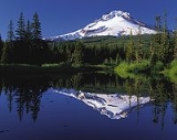
Mount Hood, called Wy'east by the Multnomah tribe
, is a stratovolcano
in the Cascade Volcanic Arc
of northern Oregon
. It was formed by a subduction zone and rests in the Pacific Northwest
region of the United States
. It is located about 50 miles (80 km) east-southeast of Portland
, on the border between Clackamas
and Hood River
counties.
The height assigned to Mount Hood's snow-covered peak has varied over its history. Modern sources point to three different heights: 11249 feet (3,429 m) based on the 1991 U.S. National Geodetic Survey
, 11240 feet (3,426 m) based on a 1993 scientific expedition, and 11239 feet (3,426 m) of slightly older origin. The peak is home to twelve glaciers. It is the highest point in Oregon and the fourth-highest in the Cascade Range
.
Mount Hood is considered the Oregon volcano most likely to erupt,
though based on its history, an explosive eruption is unlikely. Still, the odds of an eruption in the next 30 years are estimated at between 3 and 7 percent,
so the USGS characterizes it as "potentially active", but the mountain is informally considered dormant.
located on the southern flank of Mount Hood just below Palmer Glacier
.
The mountain has six ski areas: Timberline
, Mount Hood Meadows, Ski Bowl
, Cooper Spur, Snow Bunny
, and Summit
. They total over 4600 acre (7.2 sq mi; 18.6 km²) of skiable terrain; Timberline offers the only year-round lift-served skiing in North America.
Mount Hood is part of the Mount Hood National Forest
, which has 1.067 million acres (1667 sq mi/4318 km²), four designated wilderness areas
which total 189200 acre (295.6 sq mi; 765.7 km²) and more than 1200 miles (1,931.2 km) of hiking trails.
s; Pleistocene
collapses produced avalanches and lahar
s (rapidly moving mudflows) that traveled across the Columbia River
to the north. The eroded volcano has had at least four major eruptive periods during the past 15,000 years.
The last three at Mount Hood occurred within the past 1,800 years from vents high on the southwest flank and produced deposits that were distributed primarily to the south and west along the Sandy
and Zigzag
Rivers. The last eruptive period took place around 170 to 220 years ago, when dacitic lava domes, pyroclastic flows and mudflows were produced without major explosive eruptions. The prominent Crater Rock just below the summit is hypothesized to be the remains of one of these now-eroded domes. This period includes the last major eruption of 1781–82 with a slightly more recent episode ending shortly before the arrival of Lewis and Clark
in 1805. The latest minor eruptive event occurred in August 1907.
The glaciers on the mountain's upper slopes may be a source of potentially dangerous lahar
s when the mountain next erupts. There are vents near the summit that are known for emitting noxious gases such as carbon dioxide
and sulfur dioxide
. Prior to the 1980 eruption of Mount St. Helens
, the only known fatality related to volcanic activity in the Cascades occurred in 1934 when a climber suffocated in oxygen-poor air while exploring ice caves melted by fumarole
s in Coalman Glacier
.
Since 1950, there have been several earthquake swarm
s each year at Mount Hood, most notably in July 1980 and June 2002.
Seismic activity is monitored by the USGS
Cascades Volcano Observatory
located in Vancouver, Washington
, which issues weekly updates (or daily updates when significant eruptive activity is occurring at a Cascades volcano).
The most recent evidence of volcanic activity at Mount Hood consists of fumaroles near Crater Rock and hot springs
on the flanks of the volcano.
Early explorers on the Columbia River estimated the elevation to be 10000 to 12000 ft (3,048 to 3,657.6 ). Two persons in Thomas J. Dryer's 1854 expedition calculated the elevation to be 18361 feet (5,596.4 m) and that the tree line was at about 11250 feet (3,429 m). Two months later, a Mr. Belden claimed to have climbed the mountain during a hunting trip and determined it to be 19400 feet (5,913.1 m) upon which "pores oozed blood, eyes bled, and blood rushed from their ears." Sometime by 1866, Reverend G. H. Atkinson determined it to be 17600 feet (5,364.5 m). A Portland engineer used surveying methods from a Portland baseline and calculated a height of between 18000 and 19000 ft (5,486.4 and 5,791.2 ). Many maps distributed in the late 19th century cited 18361 feet (5,596.4 m), though Mitchell's School Atlas
gave 14000 feet (4,267.2 m) as the correct value. For some time, many references assumed Mount Hood to be the highest point in North America.
Modern height surveys also vary but not by the huge margins seen in the past. A 1993 survey by a scientific party who arrived at the peaks summit carrying 16 pounds of electronic equipment reported a height of 11,240 feet (3425.952 m), claimed to be accurate to within 1.25 inches (31.8 mm). Many modern sources likewise list 11240 feet (3,426 m) as the height. However, numerous others place the peak's height one foot lower, at 11239 feet (3,425.6 m). Finally, a height of 11249 feet (3,428.7 m) has also been reported.
Mount Hood's treeline varies from about 5500 feet (1,676.4 m), mostly on the western faces, to about 7000 feet (2,133.6 m), mostly on the eastern side.
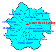 Mount Hood is host to twelve
named glaciers or snow field
s, the most visited of which is Palmer Glacier, partially within the Timberline Lodge ski area
and on the most popular climbing route. The glaciers are almost exclusively above the 6000 feet (1,828.8 m) level, which also is about the average tree line elevation on Mount Hood. More than 80% of the glacial surface area is above 7000 feet (2,133.6 m).
The glaciers and permanent snow fields have an area of 3331 acres (13.5 km²) and contain a volume of about 282000 acre.ft. Eliot Glacier is the largest glacier by volume at 73000 acre.ft, and has the thickest depth measured by ice radar at 361 feet (110 m). The largest glacier by surface area is the Coe-Ladd Glacier system at 531 acres (2.1 km²).
Glaciers and snowfields cover about 80 percent of the mountain above the 6900 feet (2,103.1 m) level. The glaciers have lost an average of 34% over the 20th century (1907–2004). Glaciers on Mount Hood retreated through the first half of the 20th century, advanced or at least slowed their retreat in the 1960s and 1970s, and have since returned to a pattern of retreat. The neo-glacial maximum extents formed in the early 18th century.
During the last major glacial event between 10,000 and 29,000 years ago, glaciers reached down to the 2300 feet (701 m) to 2600 feet (792.5 m) level: a distance of 9.3 miles (15 km) from the summit. The retreat released considerable outwash, some of which filled and flattened the upper Hood River Valley near Parkdale
and also formed Dee Flat.
Older glaciation produced moraines near Brightwood
and distinctive cuts on the southeast side; they may date to 140,000 years ago.
 The Multnomah
name for Mount Hood is Wy'east. In one version of the legend the two sons of the Great Spirit Sahale fell in love with the beautiful maiden Loowit who could not decide which to choose. The two braves, Wy'east and Klickitat, burned forests and villages in their battle over her. Sahale became enraged and smote the three lovers. Seeing what he had done he erected three mountain peaks to mark where each fell. He made beautiful Mount St. Helens
for Loowit, proud and erect Mount Hood for Wy'east, and the somber Mount Adams
for the mourning Klickitat.
There are other versions of the legend. In another telling Wy'east (Hood) battles Pahto (Adams) for the fair La-wa-la-clough (St. Helens). Or again
Wy'east, the chief of the Multnomah tribe, competed with the chief of the Klickitat tribe. Their great anger led to their transformation into volcanoes. Their battle is said to have destroyed the Bridge of the Gods
and thus created the great Cascades Rapids
of the Columbia River
.
The mountain was given its present name on October 29, 1792 by Lt. William Broughton
, a member of Captain George Vancouver
's discovery expedition. Lt. Broughton observed its peak while at Belle Vue Point of what is now called Sauvie Island
during his travels up the Columbia River, writing "A very high, snowy mountain now appeared rising beautifully conspicuous in the midst of an extensive tract of low or moderately elevated land (location of today's Vancouver, Washington
) lying S 67 E., and seemed to announce a termination to the river." Lt. Broughton named the mountain after a British
admiral
, Samuel Hood
.
Lewis and Clark were the first Americans of European descent to see the mountain, on October 18, 1805. A few days later at what would become The Dalles, Clark wrote "The pinnacle of the round topped mountain, which we saw a short distance below the banks of the river, is South 43-degrees West of us and about 37 miles (59.5 km). It is at this time topped with snow. We called this the Falls Mountain, or Timm Mountain." Timm was the native name for Celilo Falls
. Clark later noted that it was also Vancouver's Mount Hood.
Two French explorers from Hudson's Bay Company
may have traveled into the Dog River
area east of Mount Hood in 1818. They reported climbing to a glacier on "Montagne de Neige" (Mountain of Snow), probably Eliot Glacier.
 Mount Hood is Oregon's highest point and a prominent landmark visible up to a hundred miles away. It has convenient access and minimum of technical climbing challenges. About 10,000 people attempt to climb Mount Hood each year.
There are six main routes to approach the mountain with about 30 total variations for summiting. The climbs range in difficulty from class 2 to class 5.9+ (for Arachnophobia).
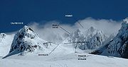
The most popular route, dubbed the south route, begins at Timberline Lodge and proceeds up Palmer Glacier to Crater Rock, the large prominence at the head of the glacier. The route goes east around Crater Rock and crosses Coalman Glacier on the Hogsback, a ridge spanning from Crater Rock to the approach to the summit. The Hogsback terminates at a bergschrund
where Coalman Glacier separates from the summit rock headwall
, and then to Pearly Gates, a gap in the summit rock formation, then right onto the summit plateau and the summit proper.
Technical ice axes, fall protection, and experience are now recommended in order to attempt the left chute variation or Pearly Gates ice chute. The Forest Service is recommending several other route options due to these changes in conditions (e.g. "Old Chute", West Crater Rim, etc.).
As of May 2002, more than 130 people had died in climbing-related accidents since records have been kept on Mount Hood, the first in 1896.
Incidents in May 1986, December 2006, and December 2009 attracted intense national and international media interest.
Though avalanches are a common hazard on other glaciated mountains, most Mount Hood climbing deaths are the result of falls and hypothermia
.
Despite a quadrupling of forest visitors since 1990, fewer than 50 people require rescue per year.
Only 3.4 percent of search and rescue missions in 2006 were for mountain climbers.
, which circumnavigates the entire mountain, was built in the 1930s by the Civilian Conservation Corps
. Typically, the 40.7 miles (65.5 km) hike is snow-free from late July until the autumn snows begin. A portion of the Pacific Crest Trail
is coincident with the Timberline Trail on the west side of Mount Hood.
.jpg) There have been two US Navy ammunition ships named for the mountain. USS Mount Hood (AE-11)
There have been two US Navy ammunition ships named for the mountain. USS Mount Hood (AE-11)
was commissioned in July 1944 and was destroyed in November 1944 while at anchor in Manus Naval Base, Admiralty Islands
. Her explosive cargo ignited resulting in 45 confirmed dead, 327 missing and 371 injured.
A second ammunition ship, AE-29
, was commissioned in May 1971 and decommissioned in August 1999.
Multnomah (tribe)
The Multnomah were a tribe of Chinookan people who lived in the area of Portland, Oregon, more specifically Sauvie Island, in the United States through the early 19th century. Multnomah villages were located throughout the Portland basin and on both sides of the Columbia River...
, is a stratovolcano
Stratovolcano
A stratovolcano, also known as a composite volcano, is a tall, conical volcano built up by many layers of hardened lava, tephra, pumice, and volcanic ash. Unlike shield volcanoes, stratovolcanoes are characterized by a steep profile and periodic, explosive eruptions...
in the Cascade Volcanic Arc
Cascade Volcanoes
The Cascade Volcanoes are a number of volcanoes in a volcanic arc in western North America, extending from southwestern British Columbia through Washington and Oregon to Northern California, a distance of well over 700 mi ...
of northern Oregon
Oregon
Oregon is a state in the Pacific Northwest region of the United States. It is located on the Pacific coast, with Washington to the north, California to the south, Nevada on the southeast and Idaho to the east. The Columbia and Snake rivers delineate much of Oregon's northern and eastern...
. It was formed by a subduction zone and rests in the Pacific Northwest
Pacific Northwest
The Pacific Northwest is a region in northwestern North America, bounded by the Pacific Ocean to the west and, loosely, by the Rocky Mountains on the east. Definitions of the region vary and there is no commonly agreed upon boundary, even among Pacific Northwesterners. A common concept of the...
region of the United States
United States
The United States of America is a federal constitutional republic comprising fifty states and a federal district...
. It is located about 50 miles (80 km) east-southeast of Portland
Portland, Oregon
Portland is a city located in the Pacific Northwest, near the confluence of the Willamette and Columbia rivers in the U.S. state of Oregon. As of the 2010 Census, it had a population of 583,776, making it the 29th most populous city in the United States...
, on the border between Clackamas
Clackamas County, Oregon
Clackamas County is a county located in the U.S. state of Oregon. The county was named after the Native Americans living in the area, the Clackamas Indians, who were part of the Chinookan people. As of 2010, the population was 375,992...
and Hood River
Hood River County, Oregon
-Demographics:As of the census of 2000, there were 20,411 people, 7,248 households, and 5,175 families residing in the county. The population density was 39 people per square mile . There were 7,818 housing units at an average density of 15 per square mile...
counties.
The height assigned to Mount Hood's snow-covered peak has varied over its history. Modern sources point to three different heights: 11249 feet (3,429 m) based on the 1991 U.S. National Geodetic Survey
U.S. National Geodetic Survey
National Geodetic Survey, formerly called the U.S. Coast and Geodetic Survey , is a United States federal agency that defines and manages a national coordinate system, providing the foundation for transportation and communication; mapping and charting; and a large number of applications of science...
, 11240 feet (3,426 m) based on a 1993 scientific expedition, and 11239 feet (3,426 m) of slightly older origin. The peak is home to twelve glaciers. It is the highest point in Oregon and the fourth-highest in the Cascade Range
Cascade Range
The Cascade Range is a major mountain range of western North America, extending from southern British Columbia through Washington and Oregon to Northern California. It includes both non-volcanic mountains, such as the North Cascades, and the notable volcanoes known as the High Cascades...
.
Mount Hood is considered the Oregon volcano most likely to erupt,
though based on its history, an explosive eruption is unlikely. Still, the odds of an eruption in the next 30 years are estimated at between 3 and 7 percent,
so the USGS characterizes it as "potentially active", but the mountain is informally considered dormant.
Facilities
Timberline Lodge is a National Historic LandmarkNational Historic Landmark
A National Historic Landmark is a building, site, structure, object, or district, that is officially recognized by the United States government for its historical significance...
located on the southern flank of Mount Hood just below Palmer Glacier
Palmer Glacier
The Palmer Glacier is a glacier located on the upper slopes of Mount Hood in the U.S. state of Oregon. It is on the south side of the mountain ranging in elevation from about 6,200 to 9,300 ft , and was named for Joel Palmer, an Oregon pioneer...
.
The mountain has six ski areas: Timberline
Timberline Lodge ski area
Timberline Lodge ski area is the ski and snowboarding area of Timberline Lodge, a National Historic Landmark in the U.S state of Oregon. It is one of a few ski lodges in the United States with most of the skiable terrain below the main lodge...
, Mount Hood Meadows, Ski Bowl
Mount Hood Skibowl
Mount Hood Skibowl is a recreation area on Mount Hood located near Government Camp, Oregon. It is the largest night ski area in the United States, and the total skiable area encompasses an area of . The resort is the closest ski venue to Portland, with an elevation of at the lodge, rising to...
, Cooper Spur, Snow Bunny
Snow Bunny
Snow Bunny is a small snow play area located in Mount Hood National Forest on the south face of Mount Hood in Oregon, USA, about east of Portland....
, and Summit
Summit Ski Area
Summit Ski Area is a small ski park located on Mount Hood, alongside the Mount Hood Highway in Government Camp, Oregon. Built in 1927, it is the oldest ski area in the Pacific Northwest. In addition to downhill skiing and snowboarding, Summit also offers innertubing and nordic trails.. The...
. They total over 4600 acre (7.2 sq mi; 18.6 km²) of skiable terrain; Timberline offers the only year-round lift-served skiing in North America.
Mount Hood is part of the Mount Hood National Forest
Mount Hood National Forest
The Mount Hood National Forest is located east of the city of Portland, Oregon, and the northern Willamette River valley. The Forest extends south from the Columbia River Gorge across more than of forested mountains, lakes and streams to the Olallie Scenic Area, a high lake basin under the slopes...
, which has 1.067 million acres (1667 sq mi/4318 km²), four designated wilderness areas
Mount Hood Wilderness
The Mount Hood Wilderness is a protected wilderness area inside the Mount Hood National Forest which is located in the U.S. state of Oregon. The area, covering , includes the peak of Mount Hood and its upper slopes, and ranges from temperate rain forests at the lower elevations, to glaciers and...
which total 189200 acre (295.6 sq mi; 765.7 km²) and more than 1200 miles (1,931.2 km) of hiking trails.
Eruption history
The glacially eroded summit area consists of several andesitic or dacitic lava domeLava dome
|250px|thumb|right|Image of the [[rhyolitic]] lava dome of [[Chaitén Volcano]] during its 2008–2009 eruption.In volcanology, a lava dome is a roughly circular mound-shaped protrusion resulting from the slow extrusion of viscous lava from a volcano...
s; Pleistocene
Pleistocene
The Pleistocene is the epoch from 2,588,000 to 11,700 years BP that spans the world's recent period of repeated glaciations. The name pleistocene is derived from the Greek and ....
collapses produced avalanches and lahar
Lahar
A lahar is a type of mudflow or debris flow composed of a slurry of pyroclastic material, rocky debris, and water. The material flows down from a volcano, typically along a river valley. The term is a shortened version of "berlahar" which originated in the Javanese language of...
s (rapidly moving mudflows) that traveled across the Columbia River
Columbia River
The Columbia River is the largest river in the Pacific Northwest region of North America. The river rises in the Rocky Mountains of British Columbia, Canada, flows northwest and then south into the U.S. state of Washington, then turns west to form most of the border between Washington and the state...
to the north. The eroded volcano has had at least four major eruptive periods during the past 15,000 years.
The last three at Mount Hood occurred within the past 1,800 years from vents high on the southwest flank and produced deposits that were distributed primarily to the south and west along the Sandy
Sandy River (Oregon)
The Sandy River is a tributary of the Columbia River in northwestern Oregon in the United States. Measured by a United States Geological Survey gauge downstream of the Sandy's confluence with the Bull Run River, from the mouth, the river's average discharge is . The maximum daily recorded flow...
and Zigzag
Zigzag River
The Zigzag River is a tributary, about long, of the Sandy River in the U.S. state of Oregon. The Zigzag and one of its major tributaries, the Little Zigzag River, drain the Zigzag Glacier on Mount Hood, a high volcanic peak in the Cascade Range. Their waters flow westward to meet the Sandy River...
Rivers. The last eruptive period took place around 170 to 220 years ago, when dacitic lava domes, pyroclastic flows and mudflows were produced without major explosive eruptions. The prominent Crater Rock just below the summit is hypothesized to be the remains of one of these now-eroded domes. This period includes the last major eruption of 1781–82 with a slightly more recent episode ending shortly before the arrival of Lewis and Clark
Lewis and Clark Expedition
The Lewis and Clark Expedition, or ″Corps of Discovery Expedition" was the first transcontinental expedition to the Pacific Coast by the United States. Commissioned by President Thomas Jefferson and led by two Virginia-born veterans of Indian wars in the Ohio Valley, Meriwether Lewis and William...
in 1805. The latest minor eruptive event occurred in August 1907.
The glaciers on the mountain's upper slopes may be a source of potentially dangerous lahar
Lahar
A lahar is a type of mudflow or debris flow composed of a slurry of pyroclastic material, rocky debris, and water. The material flows down from a volcano, typically along a river valley. The term is a shortened version of "berlahar" which originated in the Javanese language of...
s when the mountain next erupts. There are vents near the summit that are known for emitting noxious gases such as carbon dioxide
Carbon dioxide
Carbon dioxide is a naturally occurring chemical compound composed of two oxygen atoms covalently bonded to a single carbon atom...
and sulfur dioxide
Sulfur dioxide
Sulfur dioxide is the chemical compound with the formula . It is released by volcanoes and in various industrial processes. Since coal and petroleum often contain sulfur compounds, their combustion generates sulfur dioxide unless the sulfur compounds are removed before burning the fuel...
. Prior to the 1980 eruption of Mount St. Helens
1980 eruption of Mount St. Helens
The 1980 eruption of Mount St. Helens, a stratovolcano located in Washington state, in the United States, was a major volcanic eruption. The eruption was the only significant one to occur in the contiguous 48 U.S. states since the 1915 eruption of Lassen Peak in California...
, the only known fatality related to volcanic activity in the Cascades occurred in 1934 when a climber suffocated in oxygen-poor air while exploring ice caves melted by fumarole
Fumarole
A fumarole is an opening in a planet's crust, often in the neighborhood of volcanoes, which emits steam and gases such as carbon dioxide, sulfur dioxide, hydrochloric acid, and hydrogen sulfide. The steam is created when superheated water turns to steam as its pressure drops when it emerges from...
s in Coalman Glacier
Coalman Glacier
The Coalman Glacier is a glacier located on the upper slopes of Mount Hood in the U.S. state of Oregon. It is the mountain's highest glacier ranging from about 10,500 to 11,200 ft , located within the crater rim, southwest of the peak...
.
Since 1950, there have been several earthquake swarm
Earthquake swarm
Earthquake swarms are events where a local area experiences sequences of many earthquakes striking in a relatively short period of time. The length of time used to define the swarm itself varies, but the United States Geological Survey points out that an event may be on the order of days, weeks, or...
s each year at Mount Hood, most notably in July 1980 and June 2002.
Seismic activity is monitored by the USGS
United States Geological Survey
The United States Geological Survey is a scientific agency of the United States government. The scientists of the USGS study the landscape of the United States, its natural resources, and the natural hazards that threaten it. The organization has four major science disciplines, concerning biology,...
Cascades Volcano Observatory
Cascades Volcano Observatory
The David A. Johnston Cascades Volcano Observatory is the volcano observatory that monitors volcanoes in the Cascade Range. It is part of the United States Geological Survey, a scientific agency of the United States government. It is located in Vancouver, Washington in the Portland, Oregon...
located in Vancouver, Washington
Vancouver, Washington
Vancouver is a city on the north bank of the Columbia River in the U.S. state of Washington. Incorporated in 1857, it is the fourth largest city in the state with a 2010 census population of 161,791 as of April 1, 2010...
, which issues weekly updates (or daily updates when significant eruptive activity is occurring at a Cascades volcano).
The most recent evidence of volcanic activity at Mount Hood consists of fumaroles near Crater Rock and hot springs
Hot Springs
Hot Springs may refer to:* Hot Springs, Arkansas** Hot Springs National Park, Arkansas*Hot Springs, California**Hot Springs, Lassen County, California**Hot Springs, Modoc County, California**Hot Springs, Placer County, California...
on the flanks of the volcano.
Elevation
Since first seen by European explorers in 1792, Mount Hood is believed to have maintained a consistent summit elevation, varying by no more than a few feet due to mild seismic activity. Elevation changes since the 1950s are predominantly due to improved survey methods and model refinements of the shape of the Earth (see vertical reference datum). Despite the physical consistency, the estimated elevation of Mount Hood has varied substantially over the years.| Date | Elevation | By |
|---|---|---|
| 1854 | 18361 ft (5,596.4 m) | Thomas J. Dryer |
| 1854 | 19400 ft (5,913.1 m) | Belden |
| 1857 | 14000 ft (4,267.2 m) | Mitchell's School Atlas |
| 1866 | 17600 ft (5,364.5 m) | Rev. Atkinson |
| 1867 | 11225 ft (3,421.4 m) | Col. Williamson |
| 1916 | 11253 ft (3,429.9 m) | Adm. Colbert |
| 1939 | 11245 ft (3,427.5 m) | Adm. Colbert |
| 1980 | 11239 ft (3,425.6 m) | USGS U.S. National Geodetic Survey National Geodetic Survey, formerly called the U.S. Coast and Geodetic Survey , is a United States federal agency that defines and manages a national coordinate system, providing the foundation for transportation and communication; mapping and charting; and a large number of applications of science... using NGVD 29 Sea Level Datum of 1929 The Sea Level Datum of 1929 was the vertical control datum established for vertical control surveying in the United States of America by the General Adjustment of 1929. The datum was used to measure elevation above, and depression below, mean sea level .Mean sea level was measured at 26 tide... |
| 1991 | 11249 ft (3,428.7 m) | NGS U.S. National Geodetic Survey National Geodetic Survey, formerly called the U.S. Coast and Geodetic Survey , is a United States federal agency that defines and manages a national coordinate system, providing the foundation for transportation and communication; mapping and charting; and a large number of applications of science... using NAVD 88 North American Vertical Datum of 1988 The North American Vertical Datum of 1988 is the vertical control datum of orthometric height established for vertical control surveying in the United States of America based upon the General Adjustment of the North American Datum of 1988.... |
| 1993 | 11240 ft (3,426 m) | scientific expedition and 11239 feet (3,426 m) of slightly older origin. |
| 2008? | 11235 ft (3,424.4 m) | Encyclopædia Britannica |
Early explorers on the Columbia River estimated the elevation to be 10000 to 12000 ft (3,048 to 3,657.6 ). Two persons in Thomas J. Dryer's 1854 expedition calculated the elevation to be 18361 feet (5,596.4 m) and that the tree line was at about 11250 feet (3,429 m). Two months later, a Mr. Belden claimed to have climbed the mountain during a hunting trip and determined it to be 19400 feet (5,913.1 m) upon which "pores oozed blood, eyes bled, and blood rushed from their ears." Sometime by 1866, Reverend G. H. Atkinson determined it to be 17600 feet (5,364.5 m). A Portland engineer used surveying methods from a Portland baseline and calculated a height of between 18000 and 19000 ft (5,486.4 and 5,791.2 ). Many maps distributed in the late 19th century cited 18361 feet (5,596.4 m), though Mitchell's School Atlas
Mitchell's School Atlas
Mitchell's School Atlas is a series of textbooks written by Samuel Augustus Mitchell and published by H. Cowperthwait & Company of Philadelphia, Pennsylvania, in the 19th century....
gave 14000 feet (4,267.2 m) as the correct value. For some time, many references assumed Mount Hood to be the highest point in North America.
Modern height surveys also vary but not by the huge margins seen in the past. A 1993 survey by a scientific party who arrived at the peaks summit carrying 16 pounds of electronic equipment reported a height of 11,240 feet (3425.952 m), claimed to be accurate to within 1.25 inches (31.8 mm). Many modern sources likewise list 11240 feet (3,426 m) as the height. However, numerous others place the peak's height one foot lower, at 11239 feet (3,425.6 m). Finally, a height of 11249 feet (3,428.7 m) has also been reported.
Mount Hood's treeline varies from about 5500 feet (1,676.4 m), mostly on the western faces, to about 7000 feet (2,133.6 m), mostly on the eastern side.
Glaciers
named glaciers or snow field
Snow field
A snow field, snowfield or neve is a permanent accumulation of snow and ice, typically found below the snow line. Normally the term is applied to mountainous and glacial terrain. In glaciology, the term refers to areas of permanent snow cover....
s, the most visited of which is Palmer Glacier, partially within the Timberline Lodge ski area
Timberline Lodge ski area
Timberline Lodge ski area is the ski and snowboarding area of Timberline Lodge, a National Historic Landmark in the U.S state of Oregon. It is one of a few ski lodges in the United States with most of the skiable terrain below the main lodge...
and on the most popular climbing route. The glaciers are almost exclusively above the 6000 feet (1,828.8 m) level, which also is about the average tree line elevation on Mount Hood. More than 80% of the glacial surface area is above 7000 feet (2,133.6 m).
The glaciers and permanent snow fields have an area of 3331 acres (13.5 km²) and contain a volume of about 282000 acre.ft. Eliot Glacier is the largest glacier by volume at 73000 acre.ft, and has the thickest depth measured by ice radar at 361 feet (110 m). The largest glacier by surface area is the Coe-Ladd Glacier system at 531 acres (2.1 km²).
Glaciers and snowfields cover about 80 percent of the mountain above the 6900 feet (2,103.1 m) level. The glaciers have lost an average of 34% over the 20th century (1907–2004). Glaciers on Mount Hood retreated through the first half of the 20th century, advanced or at least slowed their retreat in the 1960s and 1970s, and have since returned to a pattern of retreat. The neo-glacial maximum extents formed in the early 18th century.
During the last major glacial event between 10,000 and 29,000 years ago, glaciers reached down to the 2300 feet (701 m) to 2600 feet (792.5 m) level: a distance of 9.3 miles (15 km) from the summit. The retreat released considerable outwash, some of which filled and flattened the upper Hood River Valley near Parkdale
Parkdale, Oregon
Parkdale is an unincorporated community in Hood River County, Oregon, United States. For statistical purposes, the United States Census Bureau has defined Parkdale as a census-designated place . The census definition of the area may not precisely correspond to local understanding of the area with...
and also formed Dee Flat.
Older glaciation produced moraines near Brightwood
Brightwood, Oregon
Brightwood is an unincorporated community within the Mount Hood Corridor in Clackamas County, Oregon, United States. It is located between Wemme and Sandy just off of U.S. Route 26 at an elevation of 355 meters. It is one of the communities that make up the Villages at Mount Hood.A post office...
and distinctive cuts on the southeast side; they may date to 140,000 years ago.
Name
Multnomah (tribe)
The Multnomah were a tribe of Chinookan people who lived in the area of Portland, Oregon, more specifically Sauvie Island, in the United States through the early 19th century. Multnomah villages were located throughout the Portland basin and on both sides of the Columbia River...
name for Mount Hood is Wy'east. In one version of the legend the two sons of the Great Spirit Sahale fell in love with the beautiful maiden Loowit who could not decide which to choose. The two braves, Wy'east and Klickitat, burned forests and villages in their battle over her. Sahale became enraged and smote the three lovers. Seeing what he had done he erected three mountain peaks to mark where each fell. He made beautiful Mount St. Helens
Mount St. Helens
Mount St. Helens is an active stratovolcano located in Skamania County, Washington, in the Pacific Northwest region of the United States. It is south of Seattle, Washington and northeast of Portland, Oregon. Mount St. Helens takes its English name from the British diplomat Lord St Helens, a...
for Loowit, proud and erect Mount Hood for Wy'east, and the somber Mount Adams
Mount Adams (Washington)
Mount Adams is a potentially activestratovolcano in the Cascade Range and the second-highest mountain in the U.S. state of Washington.Adams is a member of the Cascade Volcanic Arc, and is one of the arc's largest volcanoes,...
for the mourning Klickitat.
There are other versions of the legend. In another telling Wy'east (Hood) battles Pahto (Adams) for the fair La-wa-la-clough (St. Helens). Or again
Wy'east, the chief of the Multnomah tribe, competed with the chief of the Klickitat tribe. Their great anger led to their transformation into volcanoes. Their battle is said to have destroyed the Bridge of the Gods
Bridge of the Gods (geologic event)
The Bridge of the Gods was a natural dam created by the Bonneville Slide, a major landslide that dammed the Columbia River near present-day Cascade Locks, Oregon in the Pacific Northwest of the United States...
and thus created the great Cascades Rapids
Cascades Rapids
The Cascades Rapids were an area of rapids along North America's Columbia River, between the U.S. states of Washington and Oregon. Through a stretch approximately wide, the river dropped about in .-Boat portage:Boat travelers were forced to either portage boats and supplies or pull boats up with...
of the Columbia River
Columbia River
The Columbia River is the largest river in the Pacific Northwest region of North America. The river rises in the Rocky Mountains of British Columbia, Canada, flows northwest and then south into the U.S. state of Washington, then turns west to form most of the border between Washington and the state...
.
The mountain was given its present name on October 29, 1792 by Lt. William Broughton
William Robert Broughton
William Robert Broughton was a British naval officer in the late 18th century. As a Lieutenant in the Royal Navy, he commanded HMS Chatham as part of the Vancouver Expedition, a voyage of exploration through the Pacific Ocean led by Captain George Vancouver in the early 1790s.-With Vancouver:In...
, a member of Captain George Vancouver
George Vancouver
Captain George Vancouver RN was an English officer of the British Royal Navy, best known for his 1791-95 expedition, which explored and charted North America's northwestern Pacific Coast regions, including the coasts of contemporary Alaska, British Columbia, Washington and Oregon...
's discovery expedition. Lt. Broughton observed its peak while at Belle Vue Point of what is now called Sauvie Island
Sauvie Island
Sauvie Island, in the U.S. state of Oregon, originally Wapato Island or Wappatoo Island, is the largest island along the Columbia River, at 26,000 acres , and the largest river island in the United States...
during his travels up the Columbia River, writing "A very high, snowy mountain now appeared rising beautifully conspicuous in the midst of an extensive tract of low or moderately elevated land (location of today's Vancouver, Washington
Vancouver, Washington
Vancouver is a city on the north bank of the Columbia River in the U.S. state of Washington. Incorporated in 1857, it is the fourth largest city in the state with a 2010 census population of 161,791 as of April 1, 2010...
) lying S 67 E., and seemed to announce a termination to the river." Lt. Broughton named the mountain after a British
Kingdom of Great Britain
The former Kingdom of Great Britain, sometimes described as the 'United Kingdom of Great Britain', That the Two Kingdoms of Scotland and England, shall upon the 1st May next ensuing the date hereof, and forever after, be United into One Kingdom by the Name of GREAT BRITAIN. was a sovereign...
admiral
Admiral
Admiral is the rank, or part of the name of the ranks, of the highest naval officers. It is usually considered a full admiral and above vice admiral and below admiral of the fleet . It is usually abbreviated to "Adm" or "ADM"...
, Samuel Hood
Samuel Hood, 1st Viscount Hood
Samuel Hood, 1st Viscount Hood was a British Admiral known particularly for his service in the American War of Independence and French Revolutionary Wars...
.
Lewis and Clark were the first Americans of European descent to see the mountain, on October 18, 1805. A few days later at what would become The Dalles, Clark wrote "The pinnacle of the round topped mountain, which we saw a short distance below the banks of the river, is South 43-degrees West of us and about 37 miles (59.5 km). It is at this time topped with snow. We called this the Falls Mountain, or Timm Mountain." Timm was the native name for Celilo Falls
Celilo Falls
Celilo Falls was a tribal fishing area on the Columbia River, just east of the Cascade Mountains, on what is today the border between the U.S. states of Oregon and Washington...
. Clark later noted that it was also Vancouver's Mount Hood.
Two French explorers from Hudson's Bay Company
Hudson's Bay Company
The Hudson's Bay Company , abbreviated HBC, or "The Bay" is the oldest commercial corporation in North America and one of the oldest in the world. A fur trading business for much of its existence, today Hudson's Bay Company owns and operates retail stores throughout Canada...
may have traveled into the Dog River
Dog River (Oregon)
The Dog River is a small river in Oregon's Cascade Range and drains a few eastern foothills of Mount Hood. It is a tributary of East Fork Hood River and also contributes water for The Dalles and Hood River water systems....
area east of Mount Hood in 1818. They reported climbing to a glacier on "Montagne de Neige" (Mountain of Snow), probably Eliot Glacier.
Climbing
There are six main routes to approach the mountain with about 30 total variations for summiting. The climbs range in difficulty from class 2 to class 5.9+ (for Arachnophobia).
The most popular route, dubbed the south route, begins at Timberline Lodge and proceeds up Palmer Glacier to Crater Rock, the large prominence at the head of the glacier. The route goes east around Crater Rock and crosses Coalman Glacier on the Hogsback, a ridge spanning from Crater Rock to the approach to the summit. The Hogsback terminates at a bergschrund
Bergschrund
A bergschrund is a crevasse that forms where the moving glacier ice separates from the stagnant ice above. It is often a serious obstacle for mountaineers, who sometimes abbreviate "bergschrund" to "schrund"....
where Coalman Glacier separates from the summit rock headwall
Headwall
In physical geography and geology the headwall of a glacial cirque is its highest cliff.In civil engineering, a headwall is a small retaining wall placed at the outlet of a stormwater pipe or culvert....
, and then to Pearly Gates, a gap in the summit rock formation, then right onto the summit plateau and the summit proper.
Technical ice axes, fall protection, and experience are now recommended in order to attempt the left chute variation or Pearly Gates ice chute. The Forest Service is recommending several other route options due to these changes in conditions (e.g. "Old Chute", West Crater Rim, etc.).
Climbing accidents
As of May 2002, more than 130 people had died in climbing-related accidents since records have been kept on Mount Hood, the first in 1896.
Incidents in May 1986, December 2006, and December 2009 attracted intense national and international media interest.
Though avalanches are a common hazard on other glaciated mountains, most Mount Hood climbing deaths are the result of falls and hypothermia
Hypothermia
Hypothermia is a condition in which core temperature drops below the required temperature for normal metabolism and body functions which is defined as . Body temperature is usually maintained near a constant level of through biologic homeostasis or thermoregulation...
.
Despite a quadrupling of forest visitors since 1990, fewer than 50 people require rescue per year.
Only 3.4 percent of search and rescue missions in 2006 were for mountain climbers.
Hiking
The Timberline TrailTimberline Trail
Timberline Trail is a hiking trail around Mount Hood in the U.S. state of Oregon. It is in mostly wilderness but also goes near Timberline Lodge and Mount Hood Meadows ski area.- History :...
, which circumnavigates the entire mountain, was built in the 1930s by the Civilian Conservation Corps
Civilian Conservation Corps
The Civilian Conservation Corps was a public work relief program that operated from 1933 to 1942 in the United States for unemployed, unmarried men from relief families, ages 18–25. A part of the New Deal of President Franklin D...
. Typically, the 40.7 miles (65.5 km) hike is snow-free from late July until the autumn snows begin. A portion of the Pacific Crest Trail
Pacific Crest Trail
The Pacific Crest Trail is a long-distance mountain hiking and equestrian trail on the Western Seaboard of the United States. The southern terminus is at the California border with Mexico...
is coincident with the Timberline Trail on the west side of Mount Hood.
Ships
USS Mount Hood (AE-11)
USS Mount Hood was the lead ship of her class of ammunition ships for the United States Navy in World War II. She was the first ship named after Mount Hood, a volcano in the Cascade Range in Oregon...
was commissioned in July 1944 and was destroyed in November 1944 while at anchor in Manus Naval Base, Admiralty Islands
Admiralty Islands
The Admiralty Islands are a group of eighteen islands in the Bismarck Archipelago, to the north of New Guinea in the south Pacific Ocean. These are also sometimes called the Manus Islands, after the largest island. These rainforest-covered islands form part of Manus Province, the smallest and...
. Her explosive cargo ignited resulting in 45 confirmed dead, 327 missing and 371 injured.
A second ammunition ship, AE-29
USS Mount Hood (AE-29)
USS Mount Hood was a in the United States Navy. She was the second Navy ship named after Mount Hood, a volcano in the Cascade Range in Oregon....
, was commissioned in May 1971 and decommissioned in August 1999.
See also
- Cascade VolcanoesCascade VolcanoesThe Cascade Volcanoes are a number of volcanoes in a volcanic arc in western North America, extending from southwestern British Columbia through Washington and Oregon to Northern California, a distance of well over 700 mi ...
- Barlow RoadBarlow RoadThe Barlow Road is a historic road in what is now the U.S. state of Oregon. It was built in 1846 by Sam Barlow and Philip Foster, with authorization of the Provisional Legislature of Oregon, and served as the last overland segment of the Oregon Trail...
, pioneer road over the south flank built in 1846 - Mount Hood Corridor
- Mount Hood RailroadMount Hood RailroadThe Mount Hood Railroad is a heritage and shortline freight railroad located in Hood River, Oregon, east of Portland, Oregon, United States....
- Mountain peaks of North AmericaMountain peaks of North AmericaThis article comprises three sortable tables of major mountain peaks of greater North America.This article defines greater North America as the portion of the continental landmass of the Americas extending northward from Panama plus the islands surrounding that landmass...
- Mountain peaks of the United StatesMountain peaks of the United StatesThis article comprises three sortable tables of the major mountain peaks of the United States of America.Topographic elevation is the vertical distance above the reference geoid, a precise mathematical model of the Earth's sea level as an equipotential gravitational surface...
External links
- Aerial photos at HHood.