

Patagonia
Encyclopedia
Patagonia is a region located in Argentina
and Chile
, integrating the southernmost section of the Andes
mountains to the southwest towards the Pacific ocean and from the east of the cordillera to the valleys it follows south through Colorado River towards Carmen de Patagones
in the Atlantic Ocean. To the west, it includes the territory of Valdivia
through Tierra del Fuego
archipelago.
The name Patagonia comes from the word patagón
used by Magellan
in 1520 to describe the native people that his expedition thought to be giants. It is now believed the Patagons were actually Tehuelches with an average height of 180 cm (~5′11″) compared to the 155 cm (~5′1″) average for Spaniards of the time.
The Argentine portion of Patagonia includes the provinces of Neuquén
, Río Negro
, Chubut
and Santa Cruz, as well as the eastern portion of Tierra del Fuego archipelago and the southernmost department of Buenos Aires province: Patagones
. The Argentine politico-economic Patagonic Region includes the Province of La Pampa
.
Patagonia has a Welsh colony.
The Chilean part of Patagonia embraces the southern provinces and regions of Aisén and Magallanes, including the west side of Tierra del Fuego
and Cape Horn
.
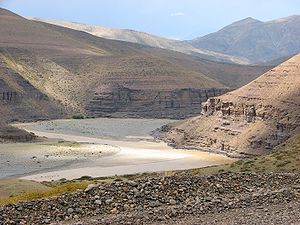
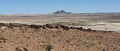
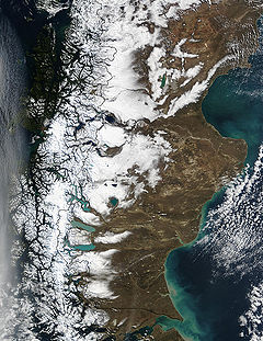
Argentine Patagonia is for the most part a region of steppe
like plains, rising in a succession of 13 abrupt terraces about 100 metres (330 ft) at a time, and covered with an enormous bed of shingle
almost bare of vegetation. In the hollows of the plains are ponds or lakes
of fresh and brackish water. Towards the Andes the shingle gives place to porphyry
, granite
, and basalt
lavas, animal life becomes more abundant and vegetation more luxuriant, acquiring the characteristics of the flora of the western coast, and consisting principally of southern beech and conifers. The high rainfall against the western Andes (Wet Andes
) and the low sea surface temperatures offshore give rise to cold and humid air masses, contributing to the ice-fields and glacier
s, the largest ice-fields in the Southern hemisphere
outside of Antarctica.
Among the depressions by which the plateau
is intersected transversely, the principal are the Gualichu
, south of the Río Negro, the Maquinchao
and Valcheta
(through which previously flowed the waters of Nahuel Huapi Lake
, which now feed the river Limay); the Senguerr (spelled Senguer on most Argentine maps and within the corresponding region), the Deseado River
. Besides these transverse depressions (some of them marking lines of ancient inter-oceanic communication), there are others which were occupied by more or less extensive lakes, such as the Yagagtoo, Musters and Colhue Huapi, and others situated to the south of Puerto Deseado, in the centre of the country. In the central region volcanic eruptions, which have taken part in the formation of the plateau from the Tertiary
period down to the present era, cover a large part with basaltic lava-caps; and in the western third more recent glacial deposits appear above the lava
. There, in contact with folded Cretaceous
rocks, uplifted by the Tertiary
granite, erosion
, caused principally by the sudden melting and retreat of the ice, aided by tectonic
changes, has scooped out a deep longitudinal depression, which generally separates the plateau from the first lofty hills, the ridges generally called the pre-Cordillera, while on the west of these there is a similar longitudinal depression all along the foot of the snowy Andean Cordillera. This latter depression contains the richest and most fertile land of Patagonia.
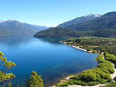
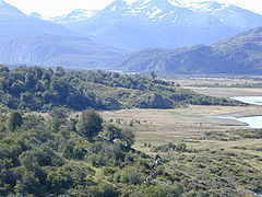
Lake basins along the Cordillera were also excavated by ice-streams, including Lake Argentino
and Lake Fagnano, as well as coastal bays such as Bahía Inútil.
physiognomy
. The Tertiary
plateau, flat on the east, gradually rising on the west, shows Upper Cretaceous
caps at its base. First come Lower Cretaceous hills raised by granite
and dioritic
rocks, undoubtedly of Tertiary origin, as in some cases these rocks have broken across the Tertiary beds, so rich in mammal
remains; then follow, on the west, metamorphic
schists of uncertain age; then quartzite
s appear, resting directly on the primitive granite and gneiss
which form the axis of the Cordillera
. Porphyritic
rocks occur between the schists and the quartzites. The Tertiary deposits are greatly varied in character, and there is considerable difference of opinion concerning the succession and correlation of the beds. They are divided by Wilckensi into the following series (in ascending order):
The Upper Cretaceous and Tertiary deposits have revealed a most interesting vertebrate
fauna. This, together with the discovery of the perfect cranium of a chelonian of the genus Myolania, which may be said to be almost identical with Myolania oweni of the Pleistocene
age in Queensland
, forms an evident proof of the connection between the Australia
n and South American continents. The Patagonian Myolania belongs to the Upper Chalk, having been found associated with remains of Dinosaur
ia. One such dinosaur to be found in Patagonia is Argentinosaurus
, which may be the largest of all dinosaurs. Other specimens of the interesting fauna of Patagonia, belonging to the Middle Tertiary, are the gigantic wingless birds, exceeding in size any hitherto known, and the singular mammal Pyrotherium
, also of very large dimensions. In the Tertiary marine formation a considerable number of cetacea
ns has been discovered. In deposits of much later date, formed when the physiognomy of the country did not differ materially from that of the present time, there have been discovered remains of pampean mammals, such as Glyptodon
and Macrauchenia
, and in a cave
near Última Esperanza Sound
, a gigantic ground sloth
(Grypoiherium listai), an animal which lived contemporaneously with humans, and whose skin, well preserved, showed that its extermination was undoubtedly very recent. With the remains of Grypotherium have been found those of the horse (Onoshippidium), which are known only from the lower pampas mud, and of the Arciotherium, which is found, although not in abundance, in even the most modern Pleistocene deposits in the pampas of Buenos Aires
. It would not be surprising if this latter animal were still in existence, for footprints, which may be attributed to it, have been observed on the borders of the rivers Tamangoand Pista, affluents of the Las Hefas, which run through the eastern foot-hills of the Cordillera in 47°S.
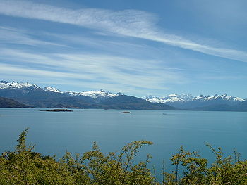
Glacier
s occupy the valleys of the main chain and some of the lateral ridges of the Andean Cordillera. In general these glaciers flow into lakes towards the East and into Pacific Ocean
fjords towards the West. Some of the larger lakes located to the east of the glaciated Cordillera include; General Carrera Lake, Cochrane/Pueyrredón Lake
, O'Higgins/San Martín Lake
, Lake Viedma
, Argentino Lake and many other smaller lakes. In turn, some of these lakes, as is the case with the first three mentioned, drain into the Pacific Ocean
through short mountainous rivers, while others, the later two lakes, flow to the Atlantic Ocean
through longer and slower moving rivers. These glacial lakes are often strewn with many icebergs. In Patagonia an immense ice-sheet extended to the east of the present Atlantic coast at the close of the Tertiary
epoch, while, during more recent glaciation, the terminal moraines have generally stopped, 50 kilometers (30 mi) in the north and 80 kilometers (50 mi) in the south, east of the summit of the Cordillera. These ice-sheets, which scooped out the greater part of the longitudinal depressions, and appear to have rapidly retreated to the point where the glaciers now exist, did not, however, in their retreat fill up with their detritus the fjord
s of the Cordillera, for these are now occupied by deep lakes on the east, and on the west by the Pacific channels, some of which are as much as 460 m (1500 ft) in depth, and soundings taken in them show that the fjords are as usual deeper in the vicinity of the mountains than to the west of the islands. Several of the high peaks are still active volcanoes.
Insofar as its main characteristics are concerned, Patagonia seems to be a portion of the Antarctic
continent, the permanence of which dates from very recent times, as is evidenced by the apparent recent emergence of the islets around Chiloé
, and by the general character of the pampean formation. Some of the promontories of Chiloé are still called huapi, the Araucanian equivalent for "islands"; and this may perhaps be accepted as perpetuating the recollection of the time when they actually were islands. They are composed of caps of shingle, with great, more or less rounded boulders, sand and volcanic ashes, precisely of the same form as occurs on the Patagonian plateau. From an examination of the pampean formation it is evident that in recent times the land of the province of Buenos Aires
extended farther to the east, and that the advance of the sea, and the salt water deposits left by it when it retired, forming some of the lowlands which occur on the littoral
and in the interior of the pampa
s, are much more recent phenomena; and certain caps of shingle, derived from rocks of a different class from those of the neighboring hills, which are observed on the Atlantic coasts of the same province, and increase in quantity and size towards the south, seem to indicate that the caps of shingle which now cover such a great part of the Patagonian territory recently extended farther to the east, over land which has now disappeared beneath the sea, while other marine deposits along the same coasts became converted into bays during the subsequent advance of the sea. There are besides, in the neighbourhood of the present coast, deposits of volcanic ashes, and the ocean throws up on its shores blocks of basaltic lava
, which in all probability proceed from eruptions of submerged volcanoes now extinct. One fact, however, which apparently demonstrates with greater certainty the existence in recent times of land that is now lost, is the presence of remains of pampean mammals in Pleistocene
deposits in the bay of Puerto San Julian
and in Santa Cruz. The animals undoubtedly reached these localities from the east; it is not at all probable that they advanced from the north southwards across the plateau intersected at that time by great rivers and covered by the ice-sheet. With the exception of the discoveries at the inlet of Ultima Esperanza, which is in close communication with the Atlantic valley of Río Gallegos, none of these remains have been discovered in the Andean regions.

 Neuquén
covers 94,078 km2 (36,324 sq. miles), including the triangle between the Limay River
and Neuquén River
, which extends southward to the northern shore of Lake Nahuel-Huapi (41°S) and northward to the Río Colorado
.
On the upper plains of Neuquén territory thousands of cattle can be fed, and the forests around Lakes Traful and Nahuel-Huapi yield large quantities of valuable timber. The Neuquén river is not navigable, but as its waters are capable of being easily dammed in places, large stretches of land in its valley are used; but the lands on each side of its lower part are of little commercial value.
As the Cordillera is approached, the soil becomes more fertile, and suitable districts for the rearing of cattle and other agricultural purposes exist between the regions which surround the Tromen
volcano and the first ridges of the Andes. Chos Malal
, the capital of the territory, is situated in one of these valleys. More to the west is the mining region, in great part unexplored, but containing deposits of gold
, silver
, copper
and lignite
. In the centre of the territory, also in the neighborhood of the mining districts, are the valleys of Norquín and Las Lajas, the general camp of the Argentine army in Patagonia, with excellent timber in the forest on the Andean slope. The wide valleys occur near Río Malleo, Lake Huechulafquén
, the river Chimehuin, and Vega de Chapelco, near Lake Lacar, where are situated villages of some importance, such as Junín de los Andes and San Martín de los Andes. Close to these are the famous apple orchard
s supposed to have been planted by the Jesuits
in the 17th and 18th centuries. These regions are drained by the river Collon Cura, the principal affluent of the river Limay
. Lake Lacar is now a contributory of the Pacific, its outlet having been changed to the west, owing to a passage having been opened through the Cordillera.
covers 203,013 km2 (78,383 sq. miles), extending from the Atlantic to the Cordillera of the Andes, to the north of 42°S.
The Río Negro (river) runs along a wide transverse depression, the middle part of which is followed by the railway which runs to the settlement of Neuquén at the confluence of the rivers Limay and Neuquen. In this depression are several settlements, among them Viedma, the capital of the Río Negro territory, Cipolletti, General Conesa, Choele Choel
and General Roca
. To the south of the Río Negro, the Patagonian plateau is intersected by the depressions of the Gualicho and Maquinchao, which in former times directed the waters of two great rivers (now disappeared) to the gulf of San Matias, the first-named depression draining the network of the Collon Cura and the second the Nahuel Huapi lake system. In 42°S there is a third broad transverse depression, apparently the bed of another great river, now perished, which carried to the Atlantic the waters of a portion of the eastern slope of the Andes, between 41° and 42°30"S.
 Chubut
, covers 224,686 km2 (86,751 sq. miles), embracing the region between 42° and 46°S;
Chubut territory presents the same characteristics as the Río Negro territory. Rawson
, the capital, is situated at the mouth of the river Chubut on the Atlantic (42°30'S). The town was founded in 1865 by a group of colonists from Wales, assisted by the Argentine government; and its prosperity has led to the foundation of other important centres in the valley, such as Trelew and Gaiman
, which is connected by railway with Puerto Madryn
on Bahía Nueva. Here is the seat of the governor of the territory, and by 1895 the inhabitants of this part of the territory, composed principally of Argentines, Welsh
and Italians
, numbered 552,585. The valley has been irrigated and cultivated, and produces the best wheat of the Argentine Republic. Between the Chubut and the Senguerr there are vast stretches of fertile land, spreading over the Andean region to the foot of the Cordillera and the lateral ridges of the Pre-Cordillera, and filling the basins of some desiccated lakes, which have been occupied since 1885, and farms and colonies founded upon them. The chief of these colonies is that of 16 de Octubre, formed in 1886, mainly by the inhabitants of Chubut colony, in the longitudinal valley which extends to the eastern foot of the Cordillera.
Other rivers in this territory flow into the Pacific through breaches in the Cordillera, e.g. the upper affluents of the Futaleufú River
, Palena and Río Cisnes. The principal affluent of the Palena, the Carrenleufu, carries off the waters of Lake General Paz, situated on the eastern slope of the Cordillera. Río Pico, an affluent of the same river, receives nearly the whole of the waters of the extensive undulating plain which lies between the Río Tecka and the Río Senguerr to the east of the Cordillera, while the remainder are carried away by the affluents of Río Jehua: the Cherque, Omkel, and Appeleg. This region contains auriferous drifts, but these, like the auriferous deposits, veins of galena
and lignite
in the mountains farther west which flank the Cordillera, have not been properly investigated. At Lake Fontana there are auriferous drifts and lignite
deposits which abound in fossil plants of the Cretaceous age. The streams which form the rivers Mayo and Chalia join the tributaries of the Río Aisén, which flows into the Pacific, watering in its course extensive and valuable districts where colonization has been initiated by Argentine settlers. Colonies have also been formed in the basin of Lakes Musters and Colhué Huapi; and on the coasts near the Atlantic, along Bahía Camarones and the Gulf of San Jorge, there are extensive farms.
In addition it is one of the highest critically acclaimed group of rivers in the world for fly fishing
. Every year thousands of fly fishermen flock there for the hope of catching "the big one".

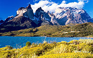
The province, mostly a cold, windswept steppe
, is well known for its extensive pebble beaches as well as for the deep-water lakes and vast glaciers in the Andes foothills along its western border with Chile. Santa Cruz's Atlantic coast is also known for the Laguna del Carbón
; lying 105 metres (330 ft) below sea level, it is the lowest geographic point in the Western Hemisphere.
 One of Santa Cruz's best-known geological curiosities is its Jaramillo Petrified Forests National Monument. Incorporated into the national park system
in 1954, the 13,700 hectare (35,000 acre) area includes one of the world's most significant remains of Jurassic
-era forests. The National Parks Administration also acquired 60,000 hectares (150,000 acres) of neighboring land, creating the largest natural steppe
preserve in South America.
Santa Cruz's most notable and most visited geographic feature, however, is probably Perito Moreno Glacier
(see section above), a national park as well.
through río Calle Calle towards the cordillera of the Andes
up to its highest peaks. There, where the waters flow to the Pacific Ocean, is the Chilean territory and where the water flows to the east towards the Atlantic ocean is a territory of Argentina.
Chilean territory stretches from Valdivia to Cape horn, including the western side of Tierra del fuego
island (62% of which is Chilean) in addition to all of Cape Horn
and the Strait of magellan
, to the north through the fjords to Chiloe island and Puerto Montt, and including in particular the Archeological site of Monte Verde
, Puerto Varas
, lake Llanquihue
, Frutillar
, Osorno
and Valdivia
.
The Tehuelches were mainly a nomad tribe that moved from east to west during the change of the seasons, following their hunting habits. Thus, before the winter, they would migrate down from the cordillera to the sea, either to the Atlantic or Pacific ocean. Chilean Patagonia was probably the closest to the sea from the cordillera, so they would travel following the rivers and creeks in order to camp and have fresh water at all times during their journey. One of the principal camps found by archeologists recently is the site of Monte Verde
near Puerto Montt, which dates 14.500 BP. This camp was based at a water creek close to the Pacific ocean, near today´s city of Puerto Montt. The Tehuelches would feed their families with fish and seafood during autumn and winter, avoiding the cold ice, snow storms and the strong polar winds of the cordillera. They would camp all winter until spring in the valleys near the rivers, lakes and fiords of the Chilean Patagonia. Then, during spring, they would travel up the rivers and creeks coming from the defrosting snow of the cordillera and live all summer until autumn in the highest valleys with fresh waters, streams and ponds containing good quantities of trout. The Tehuelches skillfully hunted deer, pumas and new guanacos during the season, in this way they would sustain their feeding habits all year. They would have their children during this period, in protected areas of the forest and Cordilleras of the Chilean Patagonia and away from the heat of the eastern and western territory. In this way they would integrate their lives into the wild forest, under a temperate temperature and climate condition.
It can be said that Chilean Patagonia is divided into two types of territories: the "Patagonia Insular" which includes all the fjords and channels along the Pacific Ocean down to Tierra del Fuego, and the "Cordillera Patagonica" which includes valleys and glaciers towards the steep mountains of the cordillera where Argentinean Patagonia begins, where the valleys are more arid and the terrain persists in the cold desert known as "Pampa Patagonica", towards the long route to the Atlantic Ocean (800 km).
, Chile
. The capital of the Province is the town of Chaitén.
Within Palena Province there are several parks and natural reserves such as the Palena Lake National Reserve, 494 square kilometres (122,070 acre) of native lenga forest, ice caps and high peaks, which can be visited only in summer because of weather conditions, it can be accessed only by horse or trekking routes.The private Pumalín Park
is also located in the province, has 3000 square kilometres (741,315 acre),it is protected by the state of Chile but owned by Douglas Tompkins, although it is private can be accessed by the Caleta Gonzalo, where lodging and camping is allowed.
In the first quarter of 2008, Chaitén Volcano increased its activity, causing damage in the town of Chaitén and spreading volcanic ashes in several tourist spots, specifically in Futaleufú.
 Aisén (also spelled Aysén) is Chile's eleventh administrative region. It is the least populated region in Chile, and it remains a region with severe communication problems because of topographical features that make it extremely difficult to quickly improve its infrastructure. The region is known for its unique ecological characteristics, including unspoiled habitat for numerous indigenous species. Its terrain and form are very similar to those of the Alaska Panhandle
, the northern Norwegian coast, and New Zealand's Milford Sound
region. Laguna San Rafael National Park
, accessible only by boat or plane, is one of its most popular tourist destinations. Until the construction of Route 7, the Southern Highway
, in the 1980s, the only overland routes from north to south through the region were extremely primitive tracks.
The Spanish electric company Endesa has recently proposed building a series of hydroelectric dams in Aisén in a project named HidroAysén
. HidroAysén project is based on water rights the company acquired before privatization during the military rule of Augusto Pinochet
. The dams would first be built on the Baker
and Pascua
rivers, but additional dams have been proposed on a number of other previously intact rivers in the area, including the Futaleufú
. The power would be transported 1200 miles (1,931.2 km) north, via a high-tension transmission line through a number of national parks and protected areas to supply power to the Santiago area, where much of the power is used for heavy industry and mining.
The project involves the installation of over 5000 high voltage towers, each covering a width of 70 metres and a height of 50 metres, and the deforestation of the native forest within the trail. The company chosen for the installation is Transelec, which was responsible of a project of similar characteristics in Canada.
A number of local, national and international environmental organizations oppose the dams, claiming they would destroy the natural heritage of the area and would lead to greatly increased electrical costs for Chilean consumers. The umbrella organization for the movement is called Patagonia Sin Represas
(translation: Patagonia Without Dams), a group that now includes over 50 international organizations.
 Magallanes and Chilean Antártica Region is the southernmost, largest and second least populated region of Chile.
This region has many globally known places and geographical accidents like Torres del Paine, Cape Horn
, Tierra del Fuego Island, and the Strait of Magellan
. It also includes the Antarctic territory claimed by Chile.
The low population and vastness makes this region a good place for many native animal and plant species. It is relatively easy to find penguin
s, ñandúes, guanacos, condor
s, and other animals in their natural environment.
The main economic activities are sheep farming, oil extraction and tourism. This region is also home to one of the world's spectacular adventure races, the Patagonia Expedition Race
.
is an archipelago
at the southernmost tip of Patagonia, divided between Argentina and Chile. It consists of the 47,992 km2 of the Isla Grande de Tierra del Fuego
, and several minor islands.
, on the inlet behind Chiloé Island. The mean annual temperature is 11 °C (52 °F) and the average extremes 25.5 °C (78 °F) and −1.5 °C (29.5 °F), whereas at Bahía Blanca
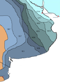
near the Atlantic coast and just outside the northern confines of Patagonia the annual temperature is 15 °C (59 °F) and the range much greater, as temperatures above 35°C and below -5°C are recorded every year. At Punta Arenas, in the extreme south, the mean temperature is 6 °C (43 °F) and the average extremes 24.5 °C (76 °F) and −2 °C (28 °F). The prevailing winds are westerly, and the westward slope has a much heavier precipitation than the eastern in a rainshadow effect; the western islands close to Torres del Paine receive an annual precipitation of 4,000 to 7,000 mm, whilst the eastern hills are less than 800 mm and the plains may be as low as 200 mm annual precipitation.
Precipitation is highly seasonal in northwestern Patagonia (for example, Villa La Angostura, in Argentina and right next to Chile, receives up to 434 mm of rain and snow in May, 297 mm in June, 273 in July, compared to 80 in February and 72 in March. The total for the city is 2074 mm, making it one of the rainiest in Argentina. Further west, some areas receive up to 4,000 mm and more, especially on the Chilean side. In the northeast, the seasons for rain are reversed: most rain falls from occasional summer thunderstorms, but totals barely reach 500 m in the northeast corner, and rapidly decrease to less than 300 mm.
The Patagonian west coast, which belongs exclusively to Chile, has a cool oceanic climate, with summer temperatures ranging from 14°C in the south to 19°C in the north (and nights between 5°C and 11°C) and very high precipitation, from 2,000 to more than 7,000 mm in local micro-climates. Snow is uncommon at the coast in the north, but happens more often in the south, and frost is usually not very intense.
Immediately east from the coast are the Andes, cut by deep fjords in the south and by deep lakes in the north, and with varying temperatures according to the altitude. The tree line ranges from close to 2,000 m on the northern side (except for the Andes in northern Neuquen in Argentina, where sunnier and dryer conditions allow trees to grow up to close to 3,000 m), and diminishes southward to only 600–800 m in Tierra del Fuego. Precipitation changes dramatically from one spot to the other, and diminishes very quickly eastward. An example of this is Laguna Frías, in Argentina, receives 4,400 mm yearly. The city of Bariloche, about 40 km further east, receives about 1,000 mm, and the airport, another 15 km east, receives less than 600 mm.
The easterly slopes of the Andes are home to several Argentine cities: San Martín de los Andes, Bariloche, El Bolsón, Esquel, El Calafate. Temperatures there are milder in the summer (in the north, between 20°C and 24°C, with cold nights between 4°C and 9°C; in the south, summers are between 16°C and 20°C, at night temperatures are similar to the north) and much colder in the winter, with frequent snowfall (although snow cover rarely lasts very long). Daytime highs range from 3°C to 9°C in the north, and from 0°C to 7°C in the south, whereas nights range from -5°C to 2°C everywhere. Cold waves can bring much colder values: -21°C have been recorded in Bariloche, and most places can often see temperatures between -12°C and -15°C and highs staying around 0°C for a few days.
Directly east of these areas, the weather becomes much harsher: precipitation drops to between 150 and 300 mm, the mountains no longer protect the cities from the wind, and temperatures become more extreme. Maquinchao is a couple hundred kilometers east of Bariloche, at the same altitude on a plateau, and summer daytime temperatures are usually about 5°C warmer, rising up to 35°C sometimes, but winter temperatures are much more extreme: the record is -35°C, and it is not uncommon to see some nights 10°C colder than Bariloche. The plateaus in Santa Cruz province and parts of Chubut usually have snow cover through the winter, and often experience very cold temperatures. In Chile, the city of Balmaceda is known for being situated in this region (which is otherwise almost exclusively in Argentina), and for being the coldest place in Chile, with temperatures below -20°C every once in a while.
The northern Atlantic coast has warm summers (28°C to 32°C, but with relatively cool nights at 15°C) and mild winters, with highs of about 12°C and lows about 2-3°C. Occasionally, temperatures reach -10°C or 40°C, and rainfall is very scarce. It only gets a bit colder further south in Chubut, and the city of Comodoro Rivadavia has summer temperatures of 24°C to 28°C, nights of 12°C to 16°C, and winters with days around 10°C and nights around 3°C, and less than 250 mm of rain. However, there is a drastic drop as we move south to Santa Cruz: Rio Gallegos, in the south of the province, has summer temps of 17°C to 21°C, (nights between 6°C and 10°C) and winter temperatures of 2°C to 6°C, with nights between -5°C and 0°C despite being right on the coast. Snowfall is common despite the dryness, and temperatures are known to fall to under -18°C and to remain below freezing for several days in a row. Rio Gallegos is also among the windiest places on Earth, with winds reaching 100 km h occasionally.
Tierra del Fuego is extremely wet in the west, relatively damp in the south, and dry in the north and east. Summers are cold (13°C to 18°C in the north, 12°C to 16°C in the south, with nights generally between 3°C and 8°C), cloudy in the south, and very windy. Winters are dark and cold, but without extreme temperatures in the south and west (Ushuaia rarely reaches -10°C, but hovers around 0°C for several months, and snow can be heavy). In the east and north, winters are much more severe, with cold snaps bringing temperatures down to -20°C all the way to Rio Grande on the Atlantic coast. Snow can fall even in the summer in most areas as well.
The depletion of the ozone layer
over the South Pole
has been reported as being responsible for blindness and skin cancer in sheep in Tierra del Fuego, and concerns for human health and ecosystems.
 The guanaco, the cougar, the Patagonian Fox (Lycalopex griseus), the Patagonian Hog-nosed Skunk
(Conepatus humboldtii), and the Magellanic Tuco-tuco
(Ctenomys magellanicus; a subterranean rodent
) are the most characteristic mammals of the Patagonian plains. The guanaco roam in herds over the country and form with the Darwin's Rhea
(Rhea pennata) formerly the chief means of subsistence for the natives, who hunted them on horseback with dogs and bolas
. Vizcachas (Lagidum spp.) and the Patagonian Mara
(Dolichotis patagonum) are also characteristic of the steppe and the Pampas to the north.
 Bird-life is often abundant. The Southern Caracara
(Caracara plancus) is one of the characteristic objects of a Patagonian landscape; the presence of Austral Parakeet
s (Enicognathus ferrugineus) as far south as the shores of the strait attracted the attention of the earlier navigators; and Green-backed Firecrown
s (Sephanoides sephaniodes), a species of hummingbird
, may be seen flying amidst the falling snow. Of the many kinds of waterfowl it is enough to mention the Chilean Flamingo
(Phoenicopterus chilensis), the Upland Goose (Chloephaga picta), and in the strait the remarkable steamer ducks.
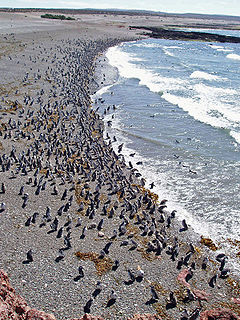
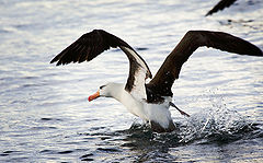
Signature marine fauna include the Southern right whale
, the Magellanic Penguin
(Spheniscus magellanicus), the Orca
and elephant seal
s. The Valdés Peninsula
is a UNESCO
World Heritage Site
for its importance as a nature reserve.
are more securely recognized. There is evidence of human activity at Monte Verde
in Llanquihue Province
, Chile dated to around 12,500 BC. The glacial period ice-fields and subsequent large meltwater streams would have made settlement difficult at that time.
The region seems to have been inhabited continuously since 10,000 BC, by various cultures and alternating waves of migration, the details of which are as yet poorly understood. Several sites have been excavated, notably caves such as Cueva del Milodon in Última Esperanza in southern Patagonia, and Tres Arroyos
on Tierra del Fuego, that support this date. Hearths, stone scrapers, animal remains dated to 9400-9200 BC have been found east of the Andes.
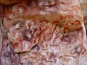 The Cueva de las Manos
is a famous site in Santa Cruz, Argentina. A cave at the foot of a cliff, it has wall paintings, particularly the negative images of hundreds of hands, believed to date from around 8000 BC.
Among tribes living on the eastern plains hunting of guanaco was the most important activity, and rhea
(ñandu) to a lesser extent, it appears from artifacts. It is unclear whether the megafauna
of Patagonia, including the ground sloth
and horse, were extinct in the area before the arrival of humans, although this is now the more widely accepted account. It is also not clear if domestic dogs were part of early human activity. Bolas
are commonly found and were used to catch guanaco and rhea. A maritime tradition existed along the Pacific coast; whose latest exponents were the Yámana
to the south of Tierra del Fuego
, the Kaweshqar between Taitao Peninsula
and Tierra del Fuego
and the Chonos in the Chonos Archipelago
.
The indigenous peoples
of the region included the Tehuelches, whose numbers and society were reduced to near extinction not long after the first contacts with Europeans. Tehuelches included the Gununa'kena to the north, Mecharnuekenk in south central Patagonia and the Aonikenk or Southern Tehuelche in the far South, north of the Magellan channel. On Isla Grande de Tierra del Fuego
, the Selk'nam (Ona) and Haush
(Mannekenk) lived in the north and south east respectively. In the archipelagos to the south of Tierra del Fuego were Yámana, with the Kawéskar (Alakaluf) in the coastal areas and islands in western Tierra del Fuego and the south west of the mainland. In the Patagonian archipelagoes north of Taitao Peninsula
lived the Chono
s. These groups were encountered in the first periods of European contact with different lifestyles, body decoration and language, although it is unclear when this configuration emerged.
Around 1000 BC, Mapuche
-speaking agriculturalists penetrated the western Andes and from there across into the eastern plains and down to the far south. Through confrontation and technological ability, they came to dominate the other peoples of the region in a short period of time, and are the principal indigenous community today. The Tehuelche model of domination through technological superiority and armed confrontation was later repeated as Europeans implemented a succeeding but conceptually identical cycle, essentially replacing the position of the former dominators with a new, albeit predominately European class.
), and others. However, it is also possible that earlier navigators such as Amerigo Vespucci
had reached the area (his own account of 1502 has it that he reached its latitudes), however his failure to accurately describe the main geographical features of the region such as the Río de la Plata
casts some doubt on whether he really did so.
Rodrigo de Isla, sent inland in 1535 from San Matias by Simón de Alcazaba Sotomayor (on whom western Patagonia had been conferred by Carlos V
of Spain), is presumed to have been the first European to have traversed the great Patagonian plain. If the men under his charge had not mutinied, he might have been able to cross the Andes to reach the Chilean side.
Pedro de Mendoza
, on whom the country was next bestowed, founded Buenos Aires
, but did not venture to the south. Alonzo de Camargo (1539), Juan Ladrilleros (1557) and Hurtado de Mendoza
(1558) helped to make known the western coasts, and Sir Francis Drake's voyage in 1577 down the eastern coast through the strait and northward by Chile and Peru was memorable, yet the description of the geography of Patagonia owes more to Pedro Sarmiento de Gamboa
(1579–1580), who, devoting himself especially to the south-west region, made careful and accurate surveys. The settlements which he founded at Nombre de Dios
and San Felipe were neglected by the Spanish government, the latter being abandoned before Thomas Cavendish
visited it in 1587 and so desolate that he called it Port Famine
. After the discovery of the route across Cape Horn the Spanish Empire lost interest in any further conquests in southern Patagonia, although it maintained its claim of a de jure
soveregnity over the area.
In 1669, the district around Puerto Deseado
, explored by John Davis
about the same period, was claimed by Sir John Narborough
for King Charles II of England
.
According to Antonio Pigafetta
, one of the Magellan expedition's few survivors and its published chronicler, Magellan bestowed the name "Patagão" (or Patagón) on the inhabitants they encountered there, and the name "Patagonia" for the region. Although Pigafetta's account does not describe how this name came about, subsequent popular interpretations gave credence to a derivation meaning 'land of the big feet'. However, this etymology
is questionable. The term is most likely derived from an actual character name, "Patagón", a savage creature confronted by Primaleón of Greece, the hero in the homonymous Spanish chivalry novel (or knight-errantry tale
) by Francisco Vázquez. This book, published in 1512, was the sequel of the romance "Palmerín de Oliva," much in fashion at the time, and a favourite reading of Magellan. Magellan's perception of the natives, dressed in skins, and eating raw meat, clearly recalled the uncivilized Patagón in Vázquez's book. Novelist and travel writer Bruce Chatwin
suggests etymological roots of both Patagon and Patagonia in his book, In Patagonia
, noting the similarity between "Patagon" and the Greek
word παταγος, which means "a roaring" or "gnashing of teeth" (in his chronicle, Pigafetta describes the Patagonians as "roaring like bulls").
 The main interest in the region sparked by Pigafetta's account came from his reports of their meeting with the local inhabitants, whom they claimed to measure some nine to twelve feet in height —"...so tall that we reached only to his waist"—, and hence the later idea that Patagonia meant "big feet". This supposed race of Patagonian giants or Patagon
es entered into the common European perception of this little-known and distant area, to be further fuelled by subsequent reports of other expeditions and famous-name travellers like Sir Francis Drake, which seemed to confirm these accounts. Early charts of the New World
sometimes added the legend regio gigantum ("region of the giants") to the Patagonian area. By 1611 the Patagonian god Setebos (Settaboth in Pigafetta) was familiar to the hearers of The Tempest.
The concept and general belief persisted for a further 250 years, and was to be sensationally re-ignited in 1767 when an "official" (but anonymous) account was published of Commodore John Byron
's recent voyage of global circumnavigation
in HMS Dolphin
. Byron and crew had spent some time along the coast, and the publication (Voyage Round the World in His Majesty's Ship the Dolphin) seemed to give proof positive of their existence; the publication became an overnight best-seller, thousands of extra copies were to be sold to a willing public, and other prior accounts of the region were hastily re-published (even those in which giant-like folk were not mentioned at all).
However, the Patagonian giant frenzy was to die down substantially only a few years later, when some more sober and analytical accounts were published. In 1773 John Hawkesworth published on behalf of the Admiralty
a compendium of noted English southern-hemisphere explorers' journals, including that of James Cook
and John Byron. In this publication, drawn from their official logs, it became clear that the people Byron's expedition had encountered were no taller than 6 in 6 in (1.98 m), very high but by no means giants. Interest soon subsided, although awareness of and belief in the myth
persisted in some quarters even up into the 20th century.
(1766, in the same HMS Dolphin which Byron had earlier sailed in) and Louis Antoine de Bougainville
(1766). Thomas Falkner
, a Jesuit who resided near forty years in those parts, published his Description of Patagonia (Hereford, 1774); Francisco Viedma founded El Carmen, nowadays Carmen de Patagones
and Antonio settled the area of San Julian Bay
, where he founded the colony of Floridablanca
and advanced inland to the Andes (1782). Basilio Villarino
ascended the Rio Negro (1782).
Two hydrographic
surveys of the coasts were of first-rate importance: the first expedition (1826–1830) including HMS Adventure
and HMS Beagle
under Phillip Parker King, and the second (1832–1836) being the voyage of the Beagle
under Robert FitzRoy
. The latter expedition is particularly noted for the participation of Charles Darwin
who spent considerable time investigating various areas of Patagonia onshore, including long rides with gaucho
s in Río Negro, and who joined FitzRoy in a 200 miles (320 km) expedition taking ships boats up the course of the Santa Cruz river
.
of the natives of northern Patagonia intensified and a lot of Mapuche
s migrated to Patagonia to live as nomads raising cattle or pillaging the Argentine countryside. The cattle stolen in the incursions (malones
) would later be taken to Chile through the mountain passes and traded for goods, especially alcoholic beverages. The main trail for this trade was called Camino de los chilenos
and run a length of about 1000 km from the Buenos Aires Province
to the mountain pass
es of Neuquén Province
. The lonco
Calfucurá
crossed the Andes
from Chile to the Pampas around 1830 after a call from the governor of Buenos Aires
, Juan Manuel de Rosas
, to fight the Boroanos
tribe. In 1859 he attacked Bahía Blanca
in Argentina
with 3,000 warriors. As in the case of Calfucura many other bands of Mapuches got involved the internal conflicts of Argentina until Conquest of the Desert
. To counter the cattle raids a trench called Zanja de Alsina
was built by Argentina in the pampas in the 1870s.
In the mid-19th century the newly-independent nations of Argentina and Chile began an aggressive phase of expansion into the south, increasing confrontation with the indigenous populations.
In 1860, a French
adventurer Orelie-Antoine de Tounens proclaimed himself king of The Kingdom of Araucania and Patagonia of the Mapuche
.
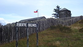
 Following the last instructions of Bernardo O'Higgins
, the Chilean president Manuel Bulnes
sent an expedition to the Strait of Magellan
and founded Fuerte Bulnes
in 1843. Five years later, the Chilean government moved the main settlement to the current location of Punta Arenas
, the oldest permanent settlement in Southern Patagonia. The creation of Punta Arenas was instrumental in making Chile's claim of the Strait of Magellan permanent. In the 1860s sheep from the Falkland Islands
were introduced to the lands around the Straits of Magellan, and throughout the 19th century the sheepfarming grew to be the most important economic sector in southern Patagonia.
Captain George Chaworth Musters in 1869 wandered in company with a band of Tehuelches through the whole length of the country from the strait to the Manzaneros in the north-west, and collected a great deal of information about the people and their mode of life.
s. Argentine authorities feared an eventual war with Chile over Patagonia where the natives would side with the Chileans and that it would therefore be fought in the vicinities of Buenos Aires
.
The decision of planning and executing the Conquest of the Desert was probably triggered by the 1872 attack of Cufulcurá and his 6,000 followers on the cities of General Alvear
, Veinticinco de Mayo and Nueve de Julio
, where 300 criollos
were killed, and 200,000 heads of cattle taken.
In the 1870s the Conquest of the Desert
was a controversial campaign by the Argentine government, executed mainly by General Julio Argentino Roca, to subdue or, some claim, to exterminate the native peoples of the South. By the mid-1880s the campaign's objectives had largely been achieved. While fighting Peru
and Bolivia
in the War of the Pacific
(1879–84) Chile waived most of its claim over the Patagonia in the Boundary treaty of 1881 between Chile and Argentina, in order to ensure Argentina's neutrality. Chilean popular belief sees this as a territorial loss of almost 500000 square miles (1,294,994.1 km²).
In 1885 a mining expeditionary party under the Romania
n adventurer Julius Popper
landed in southern Patagonia in search of gold
, which they found after travelling southwards towards the lands of Tierra del Fuego
. This further opened up some of the area to prospectors. European missionaries and settlers arrived through the 19th and 20th centuries, notably the Welsh settlement
of the Chubut Valley.
During the first years of the 20th century, the border between the two nations in Patagonia was established by the mediation of the British crown. But it has undergone a lot of modifications since then, and there is still one place (50 km long) where there is no border established (Southern Patagonia Icefield).
Until 1902, a large proportion of Patagonia's population were natives of Chiloé Archipelago
(Chilotes) who worked as peons in large livestock farming estancia
s. As manual labour
they had status below the gaucho
s and the Argentine, Chilean and European landowners and administrators.
Before and after 1902, when the boundaries were drawn, a lot of Chilotes were expelled from the Argentine side due to fear of what having a large Chilean population in Argentina could lead into in the future. These workers founded the first inland Chilean settlement in what is now the Aisén Region; Balmaceda
. Lacking good grasslands on the forest-covered Chilean side, the immigrants burned down the forest, setting fires that could last more than two years.
in 1907.
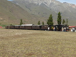
Energy production is also a crucial part of the local economy. Railways were planned to cover continental Argentine Patagonia to serve the oil, mining, agricultural and energy industries, and a line was built connecting San Carlos de Bariloche
to Buenos Aires
. Portions of other lines were built to the south, but the only lines still in use are La Trochita
in Esquel
, the 'Train of the End of the World' in Ushuaia
, both heritage lines,
and a short run Tren Histórico de Bariloche
to Perito Moreno.
 In the western forest covered Patagonian Andes and archipelagoes wood lodging has historically been an important part of the economy, and was driving force behind the colonization of the areas of Nahuel Huapi
and Lácar
lakes in Argentina and Guaitecas Archipelago
in Chile.
and Corriedale sheep common.
Livestock also includes small numbers of cattle, and in lesser numbers pigs and horses. Sheep farming provides small but important jobs located in rural areas where there is little else.
or visiting Antarctica, and adventure and activity holiday-makers. Principal tourist attractions include the Perito Moreno glacier
, the Valdés Peninsula
, Torres del Paine national park
, the Argentine Lake District and Ushuaia
and Tierra del Fuego
. Tourism has created new markets locally and for export for traditional crafts such as Mapuche handicrafts, guanaco textiles, and confectionery and preserves.
A spin-off from increased tourism has been the buying of often enormous tracts of land by foreigners, often as a prestige purchase rather than for agriculture. Buyers have included Sylvester Stallone
, Ted Turner
and Christopher Lambert
, and most notably Luciano Benetton, Patagonia's largest landowner. His Compañia de Tierras Sud has brought new techniques to the ailing sheep-rearing industry and sponsored museums and community facilities, but has been controversial particularly for its treatment of local Mapuche communities.
hopes to build a number of large hydro-electric dams in the Chilean Patagonia, which has raised environmental concerns from a large number of local and international NGOs. The first dams proposed would be built on the Baker and Pascua
rivers, but dams have also been proposed on others, including the famed Futaleufú River
in Chile and Santa Cruz river in Argentina. The dams will affect the minimum ecological flows and threaten the fishing, wilderness-tourism and agricultural interests along the river. The electricity would be fed into high-tension lines (to be built by a Canadian company) and taken 1200 miles (1,931.2 km) north to the industry and mining hub around Santiago
. The lines would cut through a number of previously pristine national parks and protected areas. The Chilean government considers the power to be essential for economic growth, while opponents claim it will destroy Patagonia's growing tourism industry. No evidence has been produced from the experience in other nations that the presence of electrical transmission lines has significantly affected tourism. In fact, opponents of the program have utilized billboard advertising in Chile which superimposes images of power lines over scenes of Torres del Paine National Park
, where no proposals for such lines have been made.
- grilled meats and pasta - with extensive use of local ingredients and less use of those products which have to be imported into the region. Lamb is considered the traditional Patagonian meat, grilled for several hours over an open fire. Some guide books have reported that game, especially guanaco and introduced deer and boar, are popular in restaurant cuisine. However, since the guanaco is a protected animal in both Chile and Argentina, it is unlikely to appear commonly as restaurant fare. Trout and centolla (king crab
) are also common, though over-fishing of centolla has made it increasingly scarce. In the area around Bariloche, there is a noted Alpine
cuisine tradition, with chocolate bars and even fondue
restaurants, and tea rooms are a feature of the Welsh communities in Gaiman
and Trevelin
as well as in the mountains.
, Ted Turner
, Joseph Lewis and the environmentalist
Douglas Tompkins
, own major land areas. This situation has caused several conflicts with local inhabitants and the governments of Chile and Argentina; for example the opposition by Douglas Tompkins to the planned route for Carretera Austral
in Pumalín Park
. A scandal is also brewing about two properties owned by Ted Turner: the estancia La Primavera, located inside Nahuel Huapi National Park
; and the estancia Collón Cura. Benetton has faced criticism from Mapuche
organizations, including Mapuche International Link
, over its purchase of traditional Mapuche lands in Patagonia. The Curiñanco-Nahuelquir family was evicted from their land in 2002 following Benetton's claim to it, but the land was restored in 2007. During discussions with indigenous rights
groups it was pointed out that the Mapuche had only acquired the disputed land through violence and armed confrontation that resulted in displacement of earlier tribes, and that a more modern model of displacement was hardly any more or less defensible than the means by which the historical Mapuche had acquired the lands during antiquity .
Argentina
Argentina , officially the Argentine Republic , is the second largest country in South America by land area, after Brazil. It is constituted as a federation of 23 provinces and an autonomous city, Buenos Aires...
and Chile
Chile
Chile ,officially the Republic of Chile , is a country in South America occupying a long, narrow coastal strip between the Andes mountains to the east and the Pacific Ocean to the west. It borders Peru to the north, Bolivia to the northeast, Argentina to the east, and the Drake Passage in the far...
, integrating the southernmost section of the Andes
Andes
The Andes is the world's longest continental mountain range. It is a continual range of highlands along the western coast of South America. This range is about long, about to wide , and of an average height of about .Along its length, the Andes is split into several ranges, which are separated...
mountains to the southwest towards the Pacific ocean and from the east of the cordillera to the valleys it follows south through Colorado River towards Carmen de Patagones
Carmen de Patagones
- Geography :It is located 937 km from the city of Buenos Aires, on the north bank of the Río Negro , near the Atlantic Ocean, and opposite Viedma, capital of the province of Río Negro...
in the Atlantic Ocean. To the west, it includes the territory of Valdivia
Valdivia
-Geography:*Chile** Valdivia, Chile, a city and municipality in the Province of Valdivia** Valdivia River, a river which begins in the city of Valdivia** Valdivia Province, the Province of Valdivia...
through Tierra del Fuego
Tierra del Fuego
Tierra del Fuego is an archipelago off the southernmost tip of the South American mainland, across the Strait of Magellan. The archipelago consists of a main island Isla Grande de Tierra del Fuego divided between Chile and Argentina with an area of , and a group of smaller islands including Cape...
archipelago.
The name Patagonia comes from the word patagón
Patagon
The Patagones or Patagonian giants are a mythical race of people, who first began to appear in early European accounts of the then little-known region and coastline of Patagonia. They were supposed to have exceeded at least double normal human height, some accounts giving heights of or more...
used by Magellan
Ferdinand Magellan
Ferdinand Magellan was a Portuguese explorer. He was born in Sabrosa, in northern Portugal, and served King Charles I of Spain in search of a westward route to the "Spice Islands" ....
in 1520 to describe the native people that his expedition thought to be giants. It is now believed the Patagons were actually Tehuelches with an average height of 180 cm (~5′11″) compared to the 155 cm (~5′1″) average for Spaniards of the time.
The Argentine portion of Patagonia includes the provinces of Neuquén
Neuquén Province
Neuquén is a province of Argentina, located in the west of the country, at the northern end of Patagonia. It borders Mendoza Province to the north, Rio Negro Province to the southeast, and Chile to the west...
, Río Negro
Río Negro Province
Río Negro is a province of Argentina, located at the northern edge of Patagonia. Neighboring provinces are from the south clockwise Chubut, Neuquén, Mendoza, La Pampa and Buenos Aires. To the east lies the Atlantic Ocean.Its capital is Viedma...
, Chubut
Chubut Province
Chubut a province in the southern part of Argentina situated between the 42nd parallel south and the 46th parallel south , the Andes range separating Argentina from Chile, and the Atlantic ocean...
and Santa Cruz, as well as the eastern portion of Tierra del Fuego archipelago and the southernmost department of Buenos Aires province: Patagones
Patagones Partido
Patagones Partido is the southernmost partido of Buenos Aires Province in Argentina.The provincial subdivision has a population of about 28,000 inhabitants in an area of 13,570 km², making it by far the largest partido in Buenos Aires Province....
. The Argentine politico-economic Patagonic Region includes the Province of La Pampa
La Pampa Province
La Pampa is a sparsely populated province of Argentina, located in the Pampas in the center of the country. Neighboring provinces are from the north clockwise San Luis, Córdoba, Buenos Aires, Río Negro, Neuquén and Mendoza.-History:...
.
Patagonia has a Welsh colony.
The Chilean part of Patagonia embraces the southern provinces and regions of Aisén and Magallanes, including the west side of Tierra del Fuego
Tierra del Fuego
Tierra del Fuego is an archipelago off the southernmost tip of the South American mainland, across the Strait of Magellan. The archipelago consists of a main island Isla Grande de Tierra del Fuego divided between Chile and Argentina with an area of , and a group of smaller islands including Cape...
and Cape Horn
Cape Horn
Cape Horn is the southernmost headland of the Tierra del Fuego archipelago of southern Chile, and is located on the small Hornos Island...
.
Population and land area
| Country | Area | Population | Density |
|---|---|---|---|
| Argentina | 2,780,400 km2 | 40,091,359 | 14.4 per km2 |
| Chile | 743,812 km2 | 16,601,707 | 22.3 per km2 |
| Patagonia | 1,043,076 km2 | 1,999,540 | 1.9 per km2 |
Physical geography
- See also: Geography of ArgentinaGeography of ArgentinaArgentina is a country in southern South America, situated between the Andes in the west and the southern Atlantic Ocean in the east. It is bordered by Paraguay and Bolivia in the north, Brazil and Uruguay in the northeast and Chile in the west....
and Geography of ChileGeography of ChileImage:Chilenav.gif|thumb|417px|left|Click over the map to obtain a topographic map of the region and its toponymyrect 23 14 119 35 rect 23 35 119 44 rect 23 44 119 54 rect 23 54 119 65 rect 23 65 119 75 rect 23 75 119 85...
Argentine Patagonia is for the most part a region of steppe
Steppe
In physical geography, steppe is an ecoregion, in the montane grasslands and shrublands and temperate grasslands, savannas, and shrublands biomes, characterized by grassland plains without trees apart from those near rivers and lakes...
like plains, rising in a succession of 13 abrupt terraces about 100 metres (330 ft) at a time, and covered with an enormous bed of shingle
Gravel
Gravel is composed of unconsolidated rock fragments that have a general particle size range and include size classes from granule- to boulder-sized fragments. Gravel can be sub-categorized into granule and cobble...
almost bare of vegetation. In the hollows of the plains are ponds or lakes
Lake
A lake is a body of relatively still fresh or salt water of considerable size, localized in a basin, that is surrounded by land. Lakes are inland and not part of the ocean and therefore are distinct from lagoons, and are larger and deeper than ponds. Lakes can be contrasted with rivers or streams,...
of fresh and brackish water. Towards the Andes the shingle gives place to porphyry
Porphyry (geology)
Porphyry is a variety of igneous rock consisting of large-grained crystals, such as feldspar or quartz, dispersed in a fine-grained feldspathic matrix or groundmass. The larger crystals are called phenocrysts...
, granite
Granite
Granite is a common and widely occurring type of intrusive, felsic, igneous rock. Granite usually has a medium- to coarse-grained texture. Occasionally some individual crystals are larger than the groundmass, in which case the texture is known as porphyritic. A granitic rock with a porphyritic...
, and basalt
Basalt
Basalt is a common extrusive volcanic rock. It is usually grey to black and fine-grained due to rapid cooling of lava at the surface of a planet. It may be porphyritic containing larger crystals in a fine matrix, or vesicular, or frothy scoria. Unweathered basalt is black or grey...
lavas, animal life becomes more abundant and vegetation more luxuriant, acquiring the characteristics of the flora of the western coast, and consisting principally of southern beech and conifers. The high rainfall against the western Andes (Wet Andes
Wet Andes
The Wet Andes is a climatic and glaciological subregion of the Andes. Together with the Dry Andes it is one of the two subregions of the Argentine and Chilean Andes. The Wet Andes runs from a latitude of 35°S to Cape Horn at 56°S. According to Luis Lliboutry the Wet Andes can be classified after...
) and the low sea surface temperatures offshore give rise to cold and humid air masses, contributing to the ice-fields and glacier
Glacier
A glacier is a large persistent body of ice that forms where the accumulation of snow exceeds its ablation over many years, often centuries. At least 0.1 km² in area and 50 m thick, but often much larger, a glacier slowly deforms and flows due to stresses induced by its weight...
s, the largest ice-fields in the Southern hemisphere
Southern Hemisphere
The Southern Hemisphere is the part of Earth that lies south of the equator. The word hemisphere literally means 'half ball' or "half sphere"...
outside of Antarctica.
Among the depressions by which the plateau
Plateau
In geology and earth science, a plateau , also called a high plain or tableland, is an area of highland, usually consisting of relatively flat terrain. A highly eroded plateau is called a dissected plateau...
is intersected transversely, the principal are the Gualichu
Gualichu
Gualichu or gualicho, in the Mapuche mythology and mainly in the Tehuelche culture, was an evil spirit or demon, comparable but not similar to the Devil.-Description:...
, south of the Río Negro, the Maquinchao
Maquinchao
Maquinchao is a village and municipality in Río Negro Province in Argentina.It is located in the middle of northern Patagonia, right in the steppe...
and Valcheta
Valcheta
Valcheta is a village and municipality in Río Negro Province in Argentina, seat of government of Valcheta Department.- History :Valcheta is one of the oldest settlements in Río Negro Province...
(through which previously flowed the waters of Nahuel Huapi Lake
Nahuel Huapi Lake
Nahuel Huapi Lake is a lake in the lake region of northern Patagonia between the provinces of Río Negro and Neuquén, in Argentina. The lake depression consists of several glacial valleys carved out along faults and Miocene valleys that were later dammed by moraines.Nahuel Huapi lake, located...
, which now feed the river Limay); the Senguerr (spelled Senguer on most Argentine maps and within the corresponding region), the Deseado River
Deseado River
Deseado River is a river in the Argentine province of Santa Cruz.The river is born from the glacier-thaw Buenos Aires Lake on the northwestern part of the province at the Andes range, and travels for 615 km before reaching the Atlantic Coast. On its way southeast, its water is tapped for...
. Besides these transverse depressions (some of them marking lines of ancient inter-oceanic communication), there are others which were occupied by more or less extensive lakes, such as the Yagagtoo, Musters and Colhue Huapi, and others situated to the south of Puerto Deseado, in the centre of the country. In the central region volcanic eruptions, which have taken part in the formation of the plateau from the Tertiary
Tertiary
The Tertiary is a deprecated term for a geologic period 65 million to 2.6 million years ago. The Tertiary covered the time span between the superseded Secondary period and the Quaternary...
period down to the present era, cover a large part with basaltic lava-caps; and in the western third more recent glacial deposits appear above the lava
Lava
Lava refers both to molten rock expelled by a volcano during an eruption and the resulting rock after solidification and cooling. This molten rock is formed in the interior of some planets, including Earth, and some of their satellites. When first erupted from a volcanic vent, lava is a liquid at...
. There, in contact with folded Cretaceous
Cretaceous
The Cretaceous , derived from the Latin "creta" , usually abbreviated K for its German translation Kreide , is a geologic period and system from circa to million years ago. In the geologic timescale, the Cretaceous follows the Jurassic period and is followed by the Paleogene period of the...
rocks, uplifted by the Tertiary
Tertiary
The Tertiary is a deprecated term for a geologic period 65 million to 2.6 million years ago. The Tertiary covered the time span between the superseded Secondary period and the Quaternary...
granite, erosion
Erosion
Erosion is when materials are removed from the surface and changed into something else. It only works by hydraulic actions and transport of solids in the natural environment, and leads to the deposition of these materials elsewhere...
, caused principally by the sudden melting and retreat of the ice, aided by tectonic
Tectonics
Tectonics is a field of study within geology concerned generally with the structures within the lithosphere of the Earth and particularly with the forces and movements that have operated in a region to create these structures.Tectonics is concerned with the orogenies and tectonic development of...
changes, has scooped out a deep longitudinal depression, which generally separates the plateau from the first lofty hills, the ridges generally called the pre-Cordillera, while on the west of these there is a similar longitudinal depression all along the foot of the snowy Andean Cordillera. This latter depression contains the richest and most fertile land of Patagonia.
Lake basins along the Cordillera were also excavated by ice-streams, including Lake Argentino
Lake Argentino
Lago Argentino is a lake in the Patagonian , at . It is the biggest freshwater lake in Argentina, with a surface area of . It has an average depth of , and a maximum depth of ....
and Lake Fagnano, as well as coastal bays such as Bahía Inútil.
Geology
The geological constitution is in accordance with the orographicMountain
Image:Himalaya_annotated.jpg|thumb|right|The Himalayan mountain range with Mount Everestrect 58 14 160 49 Chomo Lonzorect 200 28 335 52 Makalurect 378 24 566 45 Mount Everestrect 188 581 920 656 Tibetan Plateaurect 250 406 340 427 Rong River...
physiognomy
Physiognomy
Physiognomy is the assessment of a person's character or personality from their outer appearance, especially the face...
. The Tertiary
Tertiary
The Tertiary is a deprecated term for a geologic period 65 million to 2.6 million years ago. The Tertiary covered the time span between the superseded Secondary period and the Quaternary...
plateau, flat on the east, gradually rising on the west, shows Upper Cretaceous
Cretaceous
The Cretaceous , derived from the Latin "creta" , usually abbreviated K for its German translation Kreide , is a geologic period and system from circa to million years ago. In the geologic timescale, the Cretaceous follows the Jurassic period and is followed by the Paleogene period of the...
caps at its base. First come Lower Cretaceous hills raised by granite
Granite
Granite is a common and widely occurring type of intrusive, felsic, igneous rock. Granite usually has a medium- to coarse-grained texture. Occasionally some individual crystals are larger than the groundmass, in which case the texture is known as porphyritic. A granitic rock with a porphyritic...
and dioritic
Diorite
Diorite is a grey to dark grey intermediate intrusive igneous rock composed principally of plagioclase feldspar , biotite, hornblende, and/or pyroxene. It may contain small amounts of quartz, microcline and olivine. Zircon, apatite, sphene, magnetite, ilmenite and sulfides occur as accessory...
rocks, undoubtedly of Tertiary origin, as in some cases these rocks have broken across the Tertiary beds, so rich in mammal
Mammal
Mammals are members of a class of air-breathing vertebrate animals characterised by the possession of endothermy, hair, three middle ear bones, and mammary glands functional in mothers with young...
remains; then follow, on the west, metamorphic
Metamorphic rock
Metamorphic rock is the transformation of an existing rock type, the protolith, in a process called metamorphism, which means "change in form". The protolith is subjected to heat and pressure causing profound physical and/or chemical change...
schists of uncertain age; then quartzite
Quartzite
Quartzite is a hard metamorphic rock which was originally sandstone. Sandstone is converted into quartzite through heating and pressure usually related to tectonic compression within orogenic belts. Pure quartzite is usually white to gray, though quartzites often occur in various shades of pink...
s appear, resting directly on the primitive granite and gneiss
Gneiss
Gneiss is a common and widely distributed type of rock formed by high-grade regional metamorphic processes from pre-existing formations that were originally either igneous or sedimentary rocks.-Etymology:...
which form the axis of the Cordillera
Cordillera
A cordillera is an extensive chain of mountains or mountain ranges, that runs along a coastline . It comes from the Spanish word cordilla, which is a diminutive of cuerda, or "cord"...
. Porphyritic
Porphyry (geology)
Porphyry is a variety of igneous rock consisting of large-grained crystals, such as feldspar or quartz, dispersed in a fine-grained feldspathic matrix or groundmass. The larger crystals are called phenocrysts...
rocks occur between the schists and the quartzites. The Tertiary deposits are greatly varied in character, and there is considerable difference of opinion concerning the succession and correlation of the beds. They are divided by Wilckensi into the following series (in ascending order):
- Pyrotherium-Notostylops beds. Of terrestrial origin, containing remains of mammalia. EoceneEoceneThe Eocene Epoch, lasting from about 56 to 34 million years ago , is a major division of the geologic timescale and the second epoch of the Paleogene Period in the Cenozoic Era. The Eocene spans the time from the end of the Palaeocene Epoch to the beginning of the Oligocene Epoch. The start of the...
and OligoceneOligoceneThe Oligocene is a geologic epoch of the Paleogene Period and extends from about 34 million to 23 million years before the present . As with other older geologic periods, the rock beds that define the period are well identified but the exact dates of the start and end of the period are slightly...
. - Patagonian Molasse. Partly marine, partly terrestrial. Lower MioceneMioceneThe Miocene is a geological epoch of the Neogene Period and extends from about . The Miocene was named by Sir Charles Lyell. Its name comes from the Greek words and and means "less recent" because it has 18% fewer modern sea invertebrates than the Pliocene. The Miocene follows the Oligocene...
. - Santa Cruz series. Containing remains of mammals. Middle and Upper Miocene.
- Paranfl series. Sandstones and conglomerates with marine fossils. PliocenePlioceneThe Pliocene Epoch is the period in the geologic timescale that extends from 5.332 million to 2.588 million years before present. It is the second and youngest epoch of the Neogene Period in the Cenozoic Era. The Pliocene follows the Miocene Epoch and is followed by the Pleistocene Epoch...
. Confined to the eastern part of the region.
The Upper Cretaceous and Tertiary deposits have revealed a most interesting vertebrate
Vertebrate
Vertebrates are animals that are members of the subphylum Vertebrata . Vertebrates are the largest group of chordates, with currently about 58,000 species described. Vertebrates include the jawless fishes, bony fishes, sharks and rays, amphibians, reptiles, mammals, and birds...
fauna. This, together with the discovery of the perfect cranium of a chelonian of the genus Myolania, which may be said to be almost identical with Myolania oweni of the Pleistocene
Pleistocene
The Pleistocene is the epoch from 2,588,000 to 11,700 years BP that spans the world's recent period of repeated glaciations. The name pleistocene is derived from the Greek and ....
age in Queensland
Queensland
Queensland is a state of Australia, occupying the north-eastern section of the mainland continent. It is bordered by the Northern Territory, South Australia and New South Wales to the west, south-west and south respectively. To the east, Queensland is bordered by the Coral Sea and Pacific Ocean...
, forms an evident proof of the connection between the Australia
Australia
Australia , officially the Commonwealth of Australia, is a country in the Southern Hemisphere comprising the mainland of the Australian continent, the island of Tasmania, and numerous smaller islands in the Indian and Pacific Oceans. It is the world's sixth-largest country by total area...
n and South American continents. The Patagonian Myolania belongs to the Upper Chalk, having been found associated with remains of Dinosaur
Dinosaur
Dinosaurs are a diverse group of animals of the clade and superorder Dinosauria. They were the dominant terrestrial vertebrates for over 160 million years, from the late Triassic period until the end of the Cretaceous , when the Cretaceous–Paleogene extinction event led to the extinction of...
ia. One such dinosaur to be found in Patagonia is Argentinosaurus
Argentinosaurus
Argentinosaurus is a genus of titanosaur sauropod dinosaur first discovered by Guillermo Heredia in Argentina. The generic name refers to the country in which it was discovered...
, which may be the largest of all dinosaurs. Other specimens of the interesting fauna of Patagonia, belonging to the Middle Tertiary, are the gigantic wingless birds, exceeding in size any hitherto known, and the singular mammal Pyrotherium
Pyrotherium
Pyrotherium is an extinct genus of South American ungulate, of the order Pyrotheria, that lived in what is now Argentina, during the Early Oligocene...
, also of very large dimensions. In the Tertiary marine formation a considerable number of cetacea
Cetacea
The order Cetacea includes the marine mammals commonly known as whales, dolphins, and porpoises. Cetus is Latin and is used in biological names to mean "whale"; its original meaning, "large sea animal", was more general. It comes from Ancient Greek , meaning "whale" or "any huge fish or sea...
ns has been discovered. In deposits of much later date, formed when the physiognomy of the country did not differ materially from that of the present time, there have been discovered remains of pampean mammals, such as Glyptodon
Glyptodon
Glyptodon was a large, armored mammal of the family Glyptodontidae, a relative of armadillos that lived during the Pleistocene Epoch. It was roughly the same size and weight as a Volkswagen Beetle, though flatter in shape...
and Macrauchenia
Macrauchenia
Macrauchenia was a long-necked and long-limbed, three-toed South American ungulate mammal, typifying the order Litopterna. The oldest fossils date back to around 7 million years ago, and M...
, and in a cave
Cueva del Milodón Natural Monument
Cueva del Milodón Natural Monument is a Natural Monument located in the Chilean Patagonia, northwest of Puerto Natales and north of Punta Arenas. The monument is situated along the flanks of the Cerro Benitez Mountains...
near Última Esperanza Sound
Última Esperanza Sound
Última Esperanza Sound is an inlet stretching from the mouth of Eberhard Fjord to the outskirts of Monte Balmaceda, within the Magallanes Basin. This inlet, known within Chile as Seno Última Esperanza, has the characteristics of a tidewater river and drains an extensive basin...
, a gigantic ground sloth
Ground sloth
Ground sloths are a diverse group of extinct sloths, in the mammalian superorder Xenarthra. Their most recent survivors lived in the Antilles, where it has been proposed they may have survived until 1550 CE; however, the youngest AMS radiocarbon date reported is 4190 BP, calibrated to c. 4700 BP...
(Grypoiherium listai), an animal which lived contemporaneously with humans, and whose skin, well preserved, showed that its extermination was undoubtedly very recent. With the remains of Grypotherium have been found those of the horse (Onoshippidium), which are known only from the lower pampas mud, and of the Arciotherium, which is found, although not in abundance, in even the most modern Pleistocene deposits in the pampas of Buenos Aires
Buenos Aires
Buenos Aires is the capital and largest city of Argentina, and the second-largest metropolitan area in South America, after São Paulo. It is located on the western shore of the estuary of the Río de la Plata, on the southeastern coast of the South American continent...
. It would not be surprising if this latter animal were still in existence, for footprints, which may be attributed to it, have been observed on the borders of the rivers Tamangoand Pista, affluents of the Las Hefas, which run through the eastern foot-hills of the Cordillera in 47°S.
Glacier
Glacier
A glacier is a large persistent body of ice that forms where the accumulation of snow exceeds its ablation over many years, often centuries. At least 0.1 km² in area and 50 m thick, but often much larger, a glacier slowly deforms and flows due to stresses induced by its weight...
s occupy the valleys of the main chain and some of the lateral ridges of the Andean Cordillera. In general these glaciers flow into lakes towards the East and into Pacific Ocean
Pacific Ocean
The Pacific Ocean is the largest of the Earth's oceanic divisions. It extends from the Arctic in the north to the Southern Ocean in the south, bounded by Asia and Australia in the west, and the Americas in the east.At 165.2 million square kilometres in area, this largest division of the World...
fjords towards the West. Some of the larger lakes located to the east of the glaciated Cordillera include; General Carrera Lake, Cochrane/Pueyrredón Lake
Cochrane/Pueyrredón Lake
The Pueyrredón/Cochrane Lake is a glacier fed lake located on the eastern edge of the southern Andes, straddling the border between Argentina and Chile. It is named after Lord Cochrane on the Chilean side and Pueyrredón on the Argentina side. The border is a peninsula the juts out into the lake on...
, O'Higgins/San Martín Lake
O'Higgins/San Martín Lake
The lake known as O'Higgins in Chile and San Martín in Argentina is located around coordinates in Patagonia, between the Aysén Region and the Santa Cruz Province....
, Lake Viedma
Lake Viedma
Viedma Lake , approximately 50 miles long in southern Patagonia near the border between Chile and Argentina...
, Argentino Lake and many other smaller lakes. In turn, some of these lakes, as is the case with the first three mentioned, drain into the Pacific Ocean
Pacific Ocean
The Pacific Ocean is the largest of the Earth's oceanic divisions. It extends from the Arctic in the north to the Southern Ocean in the south, bounded by Asia and Australia in the west, and the Americas in the east.At 165.2 million square kilometres in area, this largest division of the World...
through short mountainous rivers, while others, the later two lakes, flow to the Atlantic Ocean
Atlantic Ocean
The Atlantic Ocean is the second-largest of the world's oceanic divisions. With a total area of about , it covers approximately 20% of the Earth's surface and about 26% of its water surface area...
through longer and slower moving rivers. These glacial lakes are often strewn with many icebergs. In Patagonia an immense ice-sheet extended to the east of the present Atlantic coast at the close of the Tertiary
Tertiary
The Tertiary is a deprecated term for a geologic period 65 million to 2.6 million years ago. The Tertiary covered the time span between the superseded Secondary period and the Quaternary...
epoch, while, during more recent glaciation, the terminal moraines have generally stopped, 50 kilometers (30 mi) in the north and 80 kilometers (50 mi) in the south, east of the summit of the Cordillera. These ice-sheets, which scooped out the greater part of the longitudinal depressions, and appear to have rapidly retreated to the point where the glaciers now exist, did not, however, in their retreat fill up with their detritus the fjord
Fjord
Geologically, a fjord is a long, narrow inlet with steep sides or cliffs, created in a valley carved by glacial activity.-Formation:A fjord is formed when a glacier cuts a U-shaped valley by abrasion of the surrounding bedrock. Glacial melting is accompanied by rebound of Earth's crust as the ice...
s of the Cordillera, for these are now occupied by deep lakes on the east, and on the west by the Pacific channels, some of which are as much as 460 m (1500 ft) in depth, and soundings taken in them show that the fjords are as usual deeper in the vicinity of the mountains than to the west of the islands. Several of the high peaks are still active volcanoes.
Insofar as its main characteristics are concerned, Patagonia seems to be a portion of the Antarctic
Antarctic
The Antarctic is the region around the Earth's South Pole, opposite the Arctic region around the North Pole. The Antarctic comprises the continent of Antarctica and the ice shelves, waters and island territories in the Southern Ocean situated south of the Antarctic Convergence...
continent, the permanence of which dates from very recent times, as is evidenced by the apparent recent emergence of the islets around Chiloé
Chiloé Island
Chiloé Island , also known as Greater Island of Chiloé , is the largest island of the Chiloé Archipelago off the coast of Chile, in the Pacific Ocean...
, and by the general character of the pampean formation. Some of the promontories of Chiloé are still called huapi, the Araucanian equivalent for "islands"; and this may perhaps be accepted as perpetuating the recollection of the time when they actually were islands. They are composed of caps of shingle, with great, more or less rounded boulders, sand and volcanic ashes, precisely of the same form as occurs on the Patagonian plateau. From an examination of the pampean formation it is evident that in recent times the land of the province of Buenos Aires
Buenos Aires
Buenos Aires is the capital and largest city of Argentina, and the second-largest metropolitan area in South America, after São Paulo. It is located on the western shore of the estuary of the Río de la Plata, on the southeastern coast of the South American continent...
extended farther to the east, and that the advance of the sea, and the salt water deposits left by it when it retired, forming some of the lowlands which occur on the littoral
Littoral
The littoral zone is that part of a sea, lake or river that is close to the shore. In coastal environments the littoral zone extends from the high water mark, which is rarely inundated, to shoreline areas that are permanently submerged. It always includes this intertidal zone and is often used to...
and in the interior of the pampa
Pampa
The Pampas are the fertile South American lowlands, covering more than , that include the Argentine provinces of Buenos Aires, La Pampa, Santa Fe, Entre Ríos and Córdoba, most of Uruguay, and the southernmost Brazilian State, Rio Grande do Sul...
s, are much more recent phenomena; and certain caps of shingle, derived from rocks of a different class from those of the neighboring hills, which are observed on the Atlantic coasts of the same province, and increase in quantity and size towards the south, seem to indicate that the caps of shingle which now cover such a great part of the Patagonian territory recently extended farther to the east, over land which has now disappeared beneath the sea, while other marine deposits along the same coasts became converted into bays during the subsequent advance of the sea. There are besides, in the neighbourhood of the present coast, deposits of volcanic ashes, and the ocean throws up on its shores blocks of basaltic lava
Lava
Lava refers both to molten rock expelled by a volcano during an eruption and the resulting rock after solidification and cooling. This molten rock is formed in the interior of some planets, including Earth, and some of their satellites. When first erupted from a volcanic vent, lava is a liquid at...
, which in all probability proceed from eruptions of submerged volcanoes now extinct. One fact, however, which apparently demonstrates with greater certainty the existence in recent times of land that is now lost, is the presence of remains of pampean mammals in Pleistocene
Pleistocene
The Pleistocene is the epoch from 2,588,000 to 11,700 years BP that spans the world's recent period of repeated glaciations. The name pleistocene is derived from the Greek and ....
deposits in the bay of Puerto San Julian
Puerto San Julián
Puerto San Julián, also known historically as Port St Julian, is a natural harbour in Patagonia in the Santa Cruz Province of Argentina located at . In the days of sailing ships it formed a stopping point, south of Puerto Deseado...
and in Santa Cruz. The animals undoubtedly reached these localities from the east; it is not at all probable that they advanced from the north southwards across the plateau intersected at that time by great rivers and covered by the ice-sheet. With the exception of the discoveries at the inlet of Ultima Esperanza, which is in close communication with the Atlantic valley of Río Gallegos, none of these remains have been discovered in the Andean regions.
Neuquén
Neuquén Province
Neuquén is a province of Argentina, located in the west of the country, at the northern end of Patagonia. It borders Mendoza Province to the north, Rio Negro Province to the southeast, and Chile to the west...
covers 94,078 km2 (36,324 sq. miles), including the triangle between the Limay River
Limay River
The Limay River is an important river in the northwestern Argentine Patagonia . It is born at the eastern end of the Nahuel Huapi Lake and flows in a meandering path for about 380 km, collecting the waters of several tributaries, such as the Traful, the Pichileufú and the Collón Curá. It then meets...
and Neuquén River
Neuquén River
The Neuquén River is the second most important river of the province of Neuquén in the Argentine Patagonia, after the Limay River.The river is born at the northwest of the province at an altitude of 2,300 metres, to be feed by a number of streams through valleys of the lower Andes while advancing...
, which extends southward to the northern shore of Lake Nahuel-Huapi (41°S) and northward to the Río Colorado
Colorado River (Argentina)
The Colorado River is a river in the south of Argentina.The Colorado river marks most of the political limit between the provinces of Neuquén and Mendoza, and between Rio Negro and La Pampa...
.
On the upper plains of Neuquén territory thousands of cattle can be fed, and the forests around Lakes Traful and Nahuel-Huapi yield large quantities of valuable timber. The Neuquén river is not navigable, but as its waters are capable of being easily dammed in places, large stretches of land in its valley are used; but the lands on each side of its lower part are of little commercial value.
As the Cordillera is approached, the soil becomes more fertile, and suitable districts for the rearing of cattle and other agricultural purposes exist between the regions which surround the Tromen
Tromen
Tromen is a stratovolcano in western Argentina. It rises above the older caldera of the Volcán Negro del Tromen.-References:*...
volcano and the first ridges of the Andes. Chos Malal
Chos Malal
Chos Malal from Mapudungun is the capital city of the Chos Malal Department located in Neuquén Province, Argentina.- History :...
, the capital of the territory, is situated in one of these valleys. More to the west is the mining region, in great part unexplored, but containing deposits of gold
Gold
Gold is a chemical element with the symbol Au and an atomic number of 79. Gold is a dense, soft, shiny, malleable and ductile metal. Pure gold has a bright yellow color and luster traditionally considered attractive, which it maintains without oxidizing in air or water. Chemically, gold is a...
, silver
Silver
Silver is a metallic chemical element with the chemical symbol Ag and atomic number 47. A soft, white, lustrous transition metal, it has the highest electrical conductivity of any element and the highest thermal conductivity of any metal...
, copper
Copper
Copper is a chemical element with the symbol Cu and atomic number 29. It is a ductile metal with very high thermal and electrical conductivity. Pure copper is soft and malleable; an exposed surface has a reddish-orange tarnish...
and lignite
Lignite
Lignite, often referred to as brown coal, or Rosebud coal by Northern Pacific Railroad,is a soft brown fuel with characteristics that put it somewhere between coal and peat...
. In the centre of the territory, also in the neighborhood of the mining districts, are the valleys of Norquín and Las Lajas, the general camp of the Argentine army in Patagonia, with excellent timber in the forest on the Andean slope. The wide valleys occur near Río Malleo, Lake Huechulafquén
Lake Huechulafquen
Huechulafquen Lake is a lake in Neuquén Province, Patagonian Argentina. This glacial lake is located in the Andean mountains in Lanín National Park some 25 kilometres from Junín de los Andes and 60 kilometres from San Martín de los Andes...
, the river Chimehuin, and Vega de Chapelco, near Lake Lacar, where are situated villages of some importance, such as Junín de los Andes and San Martín de los Andes. Close to these are the famous apple orchard
Orchard
An orchard is an intentional planting of trees or shrubs that is maintained for food production. Orchards comprise fruit or nut-producing trees which are grown for commercial production. Orchards are also sometimes a feature of large gardens, where they serve an aesthetic as well as a productive...
s supposed to have been planted by the Jesuits
Society of Jesus
The Society of Jesus is a Catholic male religious order that follows the teachings of the Catholic Church. The members are called Jesuits, and are also known colloquially as "God's Army" and as "The Company," these being references to founder Ignatius of Loyola's military background and a...
in the 17th and 18th centuries. These regions are drained by the river Collon Cura, the principal affluent of the river Limay
Limay
Limay may refer to* Limay River, in Patagonia, Argentina* Limay, a commune of Yvelines, France* Limay, a municipality of Bataan, Philippines* San Juan de Limay, a municipio of Estelí , Nicaragua...
. Lake Lacar is now a contributory of the Pacific, its outlet having been changed to the west, owing to a passage having been opened through the Cordillera.
Río Negro
Río NegroRío Negro Province
Río Negro is a province of Argentina, located at the northern edge of Patagonia. Neighboring provinces are from the south clockwise Chubut, Neuquén, Mendoza, La Pampa and Buenos Aires. To the east lies the Atlantic Ocean.Its capital is Viedma...
covers 203,013 km2 (78,383 sq. miles), extending from the Atlantic to the Cordillera of the Andes, to the north of 42°S.
The Río Negro (river) runs along a wide transverse depression, the middle part of which is followed by the railway which runs to the settlement of Neuquén at the confluence of the rivers Limay and Neuquen. In this depression are several settlements, among them Viedma, the capital of the Río Negro territory, Cipolletti, General Conesa, Choele Choel
Choele Choel
Choele Choel is the capital of the department of Avellaneda in the Argentine province of Río Negro, and the most important settlement within the Valle Medio agricultural area of the Río Negro River in Patagonia-Overview:...
and General Roca
General Roca
General Roca may refer to a number of things and places named after Argentine military Julio Argentino Roca:Places;Argentina*General Roca, Río Negro*General Roca Department, Río Negro*General Roca Department, Córdoba...
. To the south of the Río Negro, the Patagonian plateau is intersected by the depressions of the Gualicho and Maquinchao, which in former times directed the waters of two great rivers (now disappeared) to the gulf of San Matias, the first-named depression draining the network of the Collon Cura and the second the Nahuel Huapi lake system. In 42°S there is a third broad transverse depression, apparently the bed of another great river, now perished, which carried to the Atlantic the waters of a portion of the eastern slope of the Andes, between 41° and 42°30"S.
Chubut
Chubut Province
Chubut a province in the southern part of Argentina situated between the 42nd parallel south and the 46th parallel south , the Andes range separating Argentina from Chile, and the Atlantic ocean...
, covers 224,686 km2 (86,751 sq. miles), embracing the region between 42° and 46°S;
Chubut territory presents the same characteristics as the Río Negro territory. Rawson
Rawson, Chubut
Rawson is the capital of the Argentine province of Chubut, in Patagonia. It has about 26,000 inhabitants, and it is the head town of the Rawson Department, which has 122,000 inhabitants...
, the capital, is situated at the mouth of the river Chubut on the Atlantic (42°30'S). The town was founded in 1865 by a group of colonists from Wales, assisted by the Argentine government; and its prosperity has led to the foundation of other important centres in the valley, such as Trelew and Gaiman
Gaiman, Chubut
Gaiman is a town in the Chubut Province of Patagonia in Argentina. It has a population of about 6,000 as per the . It is located close to the River Chubut, about 15 km west of Trelew....
, which is connected by railway with Puerto Madryn
Puerto Madryn
Puerto Madryn is a city in the province of Chubut in the Argentine Patagonia. It is the head town of the Viedma Department, and has about 57,571 inhabitants according to the last census in 2001....
on Bahía Nueva. Here is the seat of the governor of the territory, and by 1895 the inhabitants of this part of the territory, composed principally of Argentines, Welsh
Welsh people
The Welsh people are an ethnic group and nation associated with Wales and the Welsh language.John Davies argues that the origin of the "Welsh nation" can be traced to the late 4th and early 5th centuries, following the Roman departure from Britain, although Brythonic Celtic languages seem to have...
and Italians
Italian people
The Italian people are an ethnic group that share a common Italian culture, ancestry and speak the Italian language as a mother tongue. Within Italy, Italians are defined by citizenship, regardless of ancestry or country of residence , and are distinguished from people...
, numbered 552,585. The valley has been irrigated and cultivated, and produces the best wheat of the Argentine Republic. Between the Chubut and the Senguerr there are vast stretches of fertile land, spreading over the Andean region to the foot of the Cordillera and the lateral ridges of the Pre-Cordillera, and filling the basins of some desiccated lakes, which have been occupied since 1885, and farms and colonies founded upon them. The chief of these colonies is that of 16 de Octubre, formed in 1886, mainly by the inhabitants of Chubut colony, in the longitudinal valley which extends to the eastern foot of the Cordillera.
Other rivers in this territory flow into the Pacific through breaches in the Cordillera, e.g. the upper affluents of the Futaleufú River
Futaleufú River
The Futaleufú River is a river fed by the lakes in the Los Alerces National Park in Chubut Province, Argentina, crossing the Andes Mountains and the international border into Chile and opening into the Yelcho Lake....
, Palena and Río Cisnes. The principal affluent of the Palena, the Carrenleufu, carries off the waters of Lake General Paz, situated on the eastern slope of the Cordillera. Río Pico, an affluent of the same river, receives nearly the whole of the waters of the extensive undulating plain which lies between the Río Tecka and the Río Senguerr to the east of the Cordillera, while the remainder are carried away by the affluents of Río Jehua: the Cherque, Omkel, and Appeleg. This region contains auriferous drifts, but these, like the auriferous deposits, veins of galena
Galena
Galena is the natural mineral form of lead sulfide. It is the most important lead ore mineral.Galena is one of the most abundant and widely distributed sulfide minerals. It crystallizes in the cubic crystal system often showing octahedral forms...
and lignite
Lignite
Lignite, often referred to as brown coal, or Rosebud coal by Northern Pacific Railroad,is a soft brown fuel with characteristics that put it somewhere between coal and peat...
in the mountains farther west which flank the Cordillera, have not been properly investigated. At Lake Fontana there are auriferous drifts and lignite
Lignite
Lignite, often referred to as brown coal, or Rosebud coal by Northern Pacific Railroad,is a soft brown fuel with characteristics that put it somewhere between coal and peat...
deposits which abound in fossil plants of the Cretaceous age. The streams which form the rivers Mayo and Chalia join the tributaries of the Río Aisén, which flows into the Pacific, watering in its course extensive and valuable districts where colonization has been initiated by Argentine settlers. Colonies have also been formed in the basin of Lakes Musters and Colhué Huapi; and on the coasts near the Atlantic, along Bahía Camarones and the Gulf of San Jorge, there are extensive farms.
In addition it is one of the highest critically acclaimed group of rivers in the world for fly fishing
Fly fishing
Fly fishing is an angling method in which an artificial 'fly' is used to catch fish. The fly is cast using a fly rod, reel, and specialized weighted line. Casting a nearly weightless fly or 'lure' requires casting techniques significantly different from other forms of casting...
. Every year thousands of fly fishermen flock there for the hope of catching "the big one".
Santa Cruz
Santa Cruz is the largest province in the Argentinean Patagonia and the largest political subdivision in the region as a whole, covering 293,993 km2.The province, mostly a cold, windswept steppe
Steppe
In physical geography, steppe is an ecoregion, in the montane grasslands and shrublands and temperate grasslands, savannas, and shrublands biomes, characterized by grassland plains without trees apart from those near rivers and lakes...
, is well known for its extensive pebble beaches as well as for the deep-water lakes and vast glaciers in the Andes foothills along its western border with Chile. Santa Cruz's Atlantic coast is also known for the Laguna del Carbón
Laguna del Carbón
Laguna del Carbón is an endorheic salt lake in the Gran Bajo de San Julián of Santa Cruz Province, Argentina, 54 km from Puerto San Julián...
; lying 105 metres (330 ft) below sea level, it is the lowest geographic point in the Western Hemisphere.
National Parks of Argentina
The National Parks of Argentina make up a network of 30 national parks in Argentina. The parks cover a very varied set of terrains and biotopes, from Baritú National Park on the northern border with Bolivia to Tierra del Fuego National Park in the far south of the continent .The creation of the...
in 1954, the 13,700 hectare (35,000 acre) area includes one of the world's most significant remains of Jurassic
Jurassic
The Jurassic is a geologic period and system that extends from about Mya to Mya, that is, from the end of the Triassic to the beginning of the Cretaceous. The Jurassic constitutes the middle period of the Mesozoic era, also known as the age of reptiles. The start of the period is marked by...
-era forests. The National Parks Administration also acquired 60,000 hectares (150,000 acres) of neighboring land, creating the largest natural steppe
Steppe
In physical geography, steppe is an ecoregion, in the montane grasslands and shrublands and temperate grasslands, savannas, and shrublands biomes, characterized by grassland plains without trees apart from those near rivers and lakes...
preserve in South America.
Santa Cruz's most notable and most visited geographic feature, however, is probably Perito Moreno Glacier
Perito Moreno Glacier
The Perito Moreno Glacier is a glacier located in the Los Glaciares National Park in the south west of Santa Cruz province, Argentina. It is one of the most important tourist attractions in the Argentine Patagonia....
(see section above), a national park as well.
Chilean Patagonia
Chilean Patagonia begins at the Pacific ocean in ValdiviaValdivia
-Geography:*Chile** Valdivia, Chile, a city and municipality in the Province of Valdivia** Valdivia River, a river which begins in the city of Valdivia** Valdivia Province, the Province of Valdivia...
through río Calle Calle towards the cordillera of the Andes
Andes
The Andes is the world's longest continental mountain range. It is a continual range of highlands along the western coast of South America. This range is about long, about to wide , and of an average height of about .Along its length, the Andes is split into several ranges, which are separated...
up to its highest peaks. There, where the waters flow to the Pacific Ocean, is the Chilean territory and where the water flows to the east towards the Atlantic ocean is a territory of Argentina.
Chilean territory stretches from Valdivia to Cape horn, including the western side of Tierra del fuego
Tierra del Fuego
Tierra del Fuego is an archipelago off the southernmost tip of the South American mainland, across the Strait of Magellan. The archipelago consists of a main island Isla Grande de Tierra del Fuego divided between Chile and Argentina with an area of , and a group of smaller islands including Cape...
island (62% of which is Chilean) in addition to all of Cape Horn
Cape Horn
Cape Horn is the southernmost headland of the Tierra del Fuego archipelago of southern Chile, and is located on the small Hornos Island...
and the Strait of magellan
Strait of Magellan
The Strait of Magellan comprises a navigable sea route immediately south of mainland South America and north of Tierra del Fuego...
, to the north through the fjords to Chiloe island and Puerto Montt, and including in particular the Archeological site of Monte Verde
Monte Verde
Monte Verde is an archaeological site in southern Chile, located in the northern Patagonia near Puerto Montt, Chile, which has been dated to 14,800 years BP . This dating adds to the evidence showing that settlement in the Americas pre-dates the Clovis culture by roughly 1000 years...
, Puerto Varas
Puerto Varas
Puerto Varas is a city and commune located in the southern Chilean province of Llanquihue, in the Los Lagos Region.The city is well known for its German traditions, its food, its fish and seafood, the natural environment, its casino and 5 star hotels. Only from Puerto Montt, located on the shore...
, lake Llanquihue
Lake Llanquihue
Lake Llanquihue is the second largest lake in Chile with an area of about . It is situated in the southern Los Lagos Region in the Llanquihue and Osorno provinces. The lake's fan-like form was created by successive piedmont glaciers during the Quaternary glaciations...
, Frutillar
Frutillar
Frutillar is a city and commune located in southern Chile in the Los Lagos Region. The bay of Frutillar is placed on the banks of Lake Llanquihue, the largest lake entirely within Chile.-History:...
, Osorno
Osorno, Chile
Osorno is a city and commune in southern Chile and capital of Osorno Province in the Los Lagos Region. It had a population of 145,475, as of the 2002 census...
and Valdivia
Valdivia
-Geography:*Chile** Valdivia, Chile, a city and municipality in the Province of Valdivia** Valdivia River, a river which begins in the city of Valdivia** Valdivia Province, the Province of Valdivia...
.
The Tehuelches were mainly a nomad tribe that moved from east to west during the change of the seasons, following their hunting habits. Thus, before the winter, they would migrate down from the cordillera to the sea, either to the Atlantic or Pacific ocean. Chilean Patagonia was probably the closest to the sea from the cordillera, so they would travel following the rivers and creeks in order to camp and have fresh water at all times during their journey. One of the principal camps found by archeologists recently is the site of Monte Verde
Monte Verde
Monte Verde is an archaeological site in southern Chile, located in the northern Patagonia near Puerto Montt, Chile, which has been dated to 14,800 years BP . This dating adds to the evidence showing that settlement in the Americas pre-dates the Clovis culture by roughly 1000 years...
near Puerto Montt, which dates 14.500 BP. This camp was based at a water creek close to the Pacific ocean, near today´s city of Puerto Montt. The Tehuelches would feed their families with fish and seafood during autumn and winter, avoiding the cold ice, snow storms and the strong polar winds of the cordillera. They would camp all winter until spring in the valleys near the rivers, lakes and fiords of the Chilean Patagonia. Then, during spring, they would travel up the rivers and creeks coming from the defrosting snow of the cordillera and live all summer until autumn in the highest valleys with fresh waters, streams and ponds containing good quantities of trout. The Tehuelches skillfully hunted deer, pumas and new guanacos during the season, in this way they would sustain their feeding habits all year. They would have their children during this period, in protected areas of the forest and Cordilleras of the Chilean Patagonia and away from the heat of the eastern and western territory. In this way they would integrate their lives into the wild forest, under a temperate temperature and climate condition.
It can be said that Chilean Patagonia is divided into two types of territories: the "Patagonia Insular" which includes all the fjords and channels along the Pacific Ocean down to Tierra del Fuego, and the "Cordillera Patagonica" which includes valleys and glaciers towards the steep mountains of the cordillera where Argentinean Patagonia begins, where the valleys are more arid and the terrain persists in the cold desert known as "Pampa Patagonica", towards the long route to the Atlantic Ocean (800 km).
Palena
Palena Province is one of the provinces of the Los Lagos RegionLos Lagos Region
Los Lagos Region is one of Chile's 15 regions, which are first order administrative divisions, and comprises four provinces: Chiloé, Llanquihue, Osorno and Palena. The region contains the country's second largest island, Chiloé, and the second largest lake, Llanquihue.Its capital is Puerto Montt;...
, Chile
Chile
Chile ,officially the Republic of Chile , is a country in South America occupying a long, narrow coastal strip between the Andes mountains to the east and the Pacific Ocean to the west. It borders Peru to the north, Bolivia to the northeast, Argentina to the east, and the Drake Passage in the far...
. The capital of the Province is the town of Chaitén.
Within Palena Province there are several parks and natural reserves such as the Palena Lake National Reserve, 494 square kilometres (122,070 acre) of native lenga forest, ice caps and high peaks, which can be visited only in summer because of weather conditions, it can be accessed only by horse or trekking routes.The private Pumalín Park
Pumalín Park
Pumalín Park is a private nature reserve in the Palena Province of Chile, created by the United States environmental foundation The Conservation Land Trust, which is endowed and led by the American business magnate Douglas Tompkins...
is also located in the province, has 3000 square kilometres (741,315 acre),it is protected by the state of Chile but owned by Douglas Tompkins, although it is private can be accessed by the Caleta Gonzalo, where lodging and camping is allowed.
In the first quarter of 2008, Chaitén Volcano increased its activity, causing damage in the town of Chaitén and spreading volcanic ashes in several tourist spots, specifically in Futaleufú.
Aisén
Alaska Panhandle
Southeast Alaska, sometimes referred to as the Alaska Panhandle, is the southeastern portion of the U.S. state of Alaska, which lies west of the northern half of the Canadian province of British Columbia. The majority of Southeast Alaska's area is part of the Tongass National Forest, the United...
, the northern Norwegian coast, and New Zealand's Milford Sound
Milford Sound
Milford Sound is a fjord in the south west of New Zealand's South Island, within Fiordland National Park, Piopiotahi Marine Reserve, and the Te Wahipounamu World Heritage site...
region. Laguna San Rafael National Park
Laguna San Rafael National Park
Laguna San Rafael National Park is a park located on the Pacific coast of southern Chile. The park is named for the San Rafael Lagoon formed by the retreat of the San Rafael Glacier. Created in 1959, it covers an area of and includes the Northern Patagonian Ice Field...
, accessible only by boat or plane, is one of its most popular tourist destinations. Until the construction of Route 7, the Southern Highway
Carretera Austral
The Carretera Austral , formerly known as Carretera General Augusto Pinochet, is the name given to Chile's Route 7. The highway runs about from Puerto Montt to Villa O'Higgins through rural Patagonia....
, in the 1980s, the only overland routes from north to south through the region were extremely primitive tracks.
The Spanish electric company Endesa has recently proposed building a series of hydroelectric dams in Aisén in a project named HidroAysén
HidroAysén
HidroAysén is a controversial megaproject that aims to build five hydroelectric power plants in Chile's Aysen Region. Two on the Baker River and three on the Pascua River....
. HidroAysén project is based on water rights the company acquired before privatization during the military rule of Augusto Pinochet
Augusto Pinochet
Augusto José Ramón Pinochet Ugarte, more commonly known as Augusto Pinochet , was a Chilean army general and dictator who assumed power in a coup d'état on 11 September 1973...
. The dams would first be built on the Baker
Baker River
Baker River may refer to one of the following rivers:In Chile:*Baker River In the United States:*Baker River *Baker River...
and Pascua
Pascua River
The Pascua River is a river located in the Aisén Region of Chile. In spite of being a short river, its drainage basin is the seventh-largest in the country due to the great size of the O'Higgins/San Martín Lake, its source....
rivers, but additional dams have been proposed on a number of other previously intact rivers in the area, including the Futaleufú
Futaleufú River
The Futaleufú River is a river fed by the lakes in the Los Alerces National Park in Chubut Province, Argentina, crossing the Andes Mountains and the international border into Chile and opening into the Yelcho Lake....
. The power would be transported 1200 miles (1,931.2 km) north, via a high-tension transmission line through a number of national parks and protected areas to supply power to the Santiago area, where much of the power is used for heavy industry and mining.
The project involves the installation of over 5000 high voltage towers, each covering a width of 70 metres and a height of 50 metres, and the deforestation of the native forest within the trail. The company chosen for the installation is Transelec, which was responsible of a project of similar characteristics in Canada.
A number of local, national and international environmental organizations oppose the dams, claiming they would destroy the natural heritage of the area and would lead to greatly increased electrical costs for Chilean consumers. The umbrella organization for the movement is called Patagonia Sin Represas
Patagonia Sin Represas
The phrase Patagonia Sin Represses means “Patagonia without dams.” It the slogan of people and groups who oppose the proposed hydroelectric dams in Aisén Region of Chile. The Aisén region is the XI region in Chile, home to Chile’s portion of Patagonia, the least populated region. The terrain is...
(translation: Patagonia Without Dams), a group that now includes over 50 international organizations.
Magallanes
This region has many globally known places and geographical accidents like Torres del Paine, Cape Horn
Cape Horn
Cape Horn is the southernmost headland of the Tierra del Fuego archipelago of southern Chile, and is located on the small Hornos Island...
, Tierra del Fuego Island, and the Strait of Magellan
Strait of Magellan
The Strait of Magellan comprises a navigable sea route immediately south of mainland South America and north of Tierra del Fuego...
. It also includes the Antarctic territory claimed by Chile.
The low population and vastness makes this region a good place for many native animal and plant species. It is relatively easy to find penguin
Penguin
Penguins are a group of aquatic, flightless birds living almost exclusively in the southern hemisphere, especially in Antarctica. Highly adapted for life in the water, penguins have countershaded dark and white plumage, and their wings have become flippers...
s, ñandúes, guanacos, condor
Condor
Condor is the name for two species of New World vultures, each in a monotypic genus. They are the largest flying land birds in the Western Hemisphere.They are:* The Andean Condor which inhabits the Andean mountains....
s, and other animals in their natural environment.
The main economic activities are sheep farming, oil extraction and tourism. This region is also home to one of the world's spectacular adventure races, the Patagonia Expedition Race
Patagonia Expedition Race
The Patagonian Expedition Race is an annual endurance adventure race that takes place in the remote wilderness of Chilean Patagonia, run to help protect and raise awareness about the fragile environment in this region...
.
Tierra del Fuego
Tierra del FuegoTierra del Fuego
Tierra del Fuego is an archipelago off the southernmost tip of the South American mainland, across the Strait of Magellan. The archipelago consists of a main island Isla Grande de Tierra del Fuego divided between Chile and Argentina with an area of , and a group of smaller islands including Cape...
is an archipelago
Archipelago
An archipelago , sometimes called an island group, is a chain or cluster of islands. The word archipelago is derived from the Greek ἄρχι- – arkhi- and πέλαγος – pélagos through the Italian arcipelago...
at the southernmost tip of Patagonia, divided between Argentina and Chile. It consists of the 47,992 km2 of the Isla Grande de Tierra del Fuego
Isla Grande de Tierra del Fuego
Isla Grande de Tierra del Fuego is an island near the southern tip of South America from which it is separated by the Strait of Magellan...
, and several minor islands.
Climate
Overall climate is cool and dry. The east coast is warmer than the west, especially in summer, as a branch of the southern equatorial current reaches its shores, whereas the west coast is washed by a cold current. However, winters are much colder on the eastern inland plateaus in Argentina, and the lowest extreme temperatures can be colder on the east coast than on the west coast. At Puerto MonttPuerto Montt
Puerto Montt is a port city and commune in southern Chile, located at the northern end of the Reloncaví Sound in the Llanquihue Province, Los Lagos Region. The commune spans an area of and had a population of 175,938 in 2002. It is located 1,055 km to the south of the capital, Santiago...
, on the inlet behind Chiloé Island. The mean annual temperature is 11 °C (52 °F) and the average extremes 25.5 °C (78 °F) and −1.5 °C (29.5 °F), whereas at Bahía Blanca
Bahía Blanca
Bahía Blanca is a city located in the south-west of the province of Buenos Aires, Argentina, by the Atlantic Ocean, and seat of government of Bahía Blanca Partido. It has a population of 274,509 inhabitants according to the...
near the Atlantic coast and just outside the northern confines of Patagonia the annual temperature is 15 °C (59 °F) and the range much greater, as temperatures above 35°C and below -5°C are recorded every year. At Punta Arenas, in the extreme south, the mean temperature is 6 °C (43 °F) and the average extremes 24.5 °C (76 °F) and −2 °C (28 °F). The prevailing winds are westerly, and the westward slope has a much heavier precipitation than the eastern in a rainshadow effect; the western islands close to Torres del Paine receive an annual precipitation of 4,000 to 7,000 mm, whilst the eastern hills are less than 800 mm and the plains may be as low as 200 mm annual precipitation.
Precipitation is highly seasonal in northwestern Patagonia (for example, Villa La Angostura, in Argentina and right next to Chile, receives up to 434 mm of rain and snow in May, 297 mm in June, 273 in July, compared to 80 in February and 72 in March. The total for the city is 2074 mm, making it one of the rainiest in Argentina. Further west, some areas receive up to 4,000 mm and more, especially on the Chilean side. In the northeast, the seasons for rain are reversed: most rain falls from occasional summer thunderstorms, but totals barely reach 500 m in the northeast corner, and rapidly decrease to less than 300 mm.
The Patagonian west coast, which belongs exclusively to Chile, has a cool oceanic climate, with summer temperatures ranging from 14°C in the south to 19°C in the north (and nights between 5°C and 11°C) and very high precipitation, from 2,000 to more than 7,000 mm in local micro-climates. Snow is uncommon at the coast in the north, but happens more often in the south, and frost is usually not very intense.
Immediately east from the coast are the Andes, cut by deep fjords in the south and by deep lakes in the north, and with varying temperatures according to the altitude. The tree line ranges from close to 2,000 m on the northern side (except for the Andes in northern Neuquen in Argentina, where sunnier and dryer conditions allow trees to grow up to close to 3,000 m), and diminishes southward to only 600–800 m in Tierra del Fuego. Precipitation changes dramatically from one spot to the other, and diminishes very quickly eastward. An example of this is Laguna Frías, in Argentina, receives 4,400 mm yearly. The city of Bariloche, about 40 km further east, receives about 1,000 mm, and the airport, another 15 km east, receives less than 600 mm.
The easterly slopes of the Andes are home to several Argentine cities: San Martín de los Andes, Bariloche, El Bolsón, Esquel, El Calafate. Temperatures there are milder in the summer (in the north, between 20°C and 24°C, with cold nights between 4°C and 9°C; in the south, summers are between 16°C and 20°C, at night temperatures are similar to the north) and much colder in the winter, with frequent snowfall (although snow cover rarely lasts very long). Daytime highs range from 3°C to 9°C in the north, and from 0°C to 7°C in the south, whereas nights range from -5°C to 2°C everywhere. Cold waves can bring much colder values: -21°C have been recorded in Bariloche, and most places can often see temperatures between -12°C and -15°C and highs staying around 0°C for a few days.
Directly east of these areas, the weather becomes much harsher: precipitation drops to between 150 and 300 mm, the mountains no longer protect the cities from the wind, and temperatures become more extreme. Maquinchao is a couple hundred kilometers east of Bariloche, at the same altitude on a plateau, and summer daytime temperatures are usually about 5°C warmer, rising up to 35°C sometimes, but winter temperatures are much more extreme: the record is -35°C, and it is not uncommon to see some nights 10°C colder than Bariloche. The plateaus in Santa Cruz province and parts of Chubut usually have snow cover through the winter, and often experience very cold temperatures. In Chile, the city of Balmaceda is known for being situated in this region (which is otherwise almost exclusively in Argentina), and for being the coldest place in Chile, with temperatures below -20°C every once in a while.
The northern Atlantic coast has warm summers (28°C to 32°C, but with relatively cool nights at 15°C) and mild winters, with highs of about 12°C and lows about 2-3°C. Occasionally, temperatures reach -10°C or 40°C, and rainfall is very scarce. It only gets a bit colder further south in Chubut, and the city of Comodoro Rivadavia has summer temperatures of 24°C to 28°C, nights of 12°C to 16°C, and winters with days around 10°C and nights around 3°C, and less than 250 mm of rain. However, there is a drastic drop as we move south to Santa Cruz: Rio Gallegos, in the south of the province, has summer temps of 17°C to 21°C, (nights between 6°C and 10°C) and winter temperatures of 2°C to 6°C, with nights between -5°C and 0°C despite being right on the coast. Snowfall is common despite the dryness, and temperatures are known to fall to under -18°C and to remain below freezing for several days in a row. Rio Gallegos is also among the windiest places on Earth, with winds reaching 100 km h occasionally.
Tierra del Fuego is extremely wet in the west, relatively damp in the south, and dry in the north and east. Summers are cold (13°C to 18°C in the north, 12°C to 16°C in the south, with nights generally between 3°C and 8°C), cloudy in the south, and very windy. Winters are dark and cold, but without extreme temperatures in the south and west (Ushuaia rarely reaches -10°C, but hovers around 0°C for several months, and snow can be heavy). In the east and north, winters are much more severe, with cold snaps bringing temperatures down to -20°C all the way to Rio Grande on the Atlantic coast. Snow can fall even in the summer in most areas as well.
The depletion of the ozone layer
Ozone layer
The ozone layer is a layer in Earth's atmosphere which contains relatively high concentrations of ozone . This layer absorbs 97–99% of the Sun's high frequency ultraviolet light, which is potentially damaging to the life forms on Earth...
over the South Pole
South Pole
The South Pole, also known as the Geographic South Pole or Terrestrial South Pole, is one of the two points where the Earth's axis of rotation intersects its surface. It is the southernmost point on the surface of the Earth and lies on the opposite side of the Earth from the North Pole...
has been reported as being responsible for blindness and skin cancer in sheep in Tierra del Fuego, and concerns for human health and ecosystems.
Fauna
Humboldt's Hog-nosed Skunk
Humboldt's hog-nosed skunk, also known as the Patagonian hog-nosed skunk is a type of hog-nosed skunk indigenous to the open grassy areas in the Patagonian regions of Argentina and Chile.- Appearance :...
(Conepatus humboldtii), and the Magellanic Tuco-tuco
Magellanic Tuco-tuco
The Magellanic Tuco-tuco is a species of rodent in the family Ctenomyidae.It is found in Argentina and Chile.Its natural habitat is subtropical or tropical dry lowland grassland....
(Ctenomys magellanicus; a subterranean rodent
Rodent
Rodentia is an order of mammals also known as rodents, characterised by two continuously growing incisors in the upper and lower jaws which must be kept short by gnawing....
) are the most characteristic mammals of the Patagonian plains. The guanaco roam in herds over the country and form with the Darwin's Rhea
Darwin's Rhea
Darwin's Rhea, Rhea pennata, also known as the Lesser Rhea, is a large flightless bird, but the smaller of the two extant species of rheas. It is found in the Altiplano and Patagonia in South America.-Description:...
(Rhea pennata) formerly the chief means of subsistence for the natives, who hunted them on horseback with dogs and bolas
Bolas
Bolas are a throwing weapon superficially similar to the surujin, made of weights on the ends of interconnected cords, designed to capture animals by entangling their legs...
. Vizcachas (Lagidum spp.) and the Patagonian Mara
Patagonian Mara
The Patagonian Mara, Dolichotis patagonum, is a relatively large rodent in the mara genus . It is also known as the Patagonian cavy or Patagonian hare. This herbivorous, somewhat rabbit-like animal is found in open and semi-open habitats in Argentina, including large parts of Patagonia...
(Dolichotis patagonum) are also characteristic of the steppe and the Pampas to the north.
Southern Caracara
The Southern Crested Caracara , also known as the Southern Caracara, is a bird of prey in the family Falconidae. It formerly included the Northern Caracara of the southern United States, Mexico, Central America and northern South America, and the extinct Guadalupe Caracara as subspecies...
(Caracara plancus) is one of the characteristic objects of a Patagonian landscape; the presence of Austral Parakeet
Austral Parakeet
The Austral Parakeet, Austral Conure or Emerald Parakeet, Enicognathus ferrugineus, is a parrot found on the southern tip of South America - further south than any other parrot - ranging as far north as Temuco. It is a fairly large conure, 35cm...
s (Enicognathus ferrugineus) as far south as the shores of the strait attracted the attention of the earlier navigators; and Green-backed Firecrown
Green-backed Firecrown
The Green-backed Firecrown is a hummingbird that is found in Argentina and Chile. It can be fairly common in some locations, especially the Robinson Crusoe Island, 350 miles off the Chilean coast. It is found as far south as Tierra del Fuego.Like its cousin the Juan Fernández Firecrown, the...
s (Sephanoides sephaniodes), a species of hummingbird
Hummingbird
Hummingbirds are birds that comprise the family Trochilidae. They are among the smallest of birds, most species measuring in the 7.5–13 cm range. Indeed, the smallest extant bird species is a hummingbird, the 5-cm Bee Hummingbird. They can hover in mid-air by rapidly flapping their wings...
, may be seen flying amidst the falling snow. Of the many kinds of waterfowl it is enough to mention the Chilean Flamingo
Chilean Flamingo
The Chilean Flamingo is a large species closely related to Caribbean Flamingo and Greater Flamingo, with which it was sometimes considered conspecific...
(Phoenicopterus chilensis), the Upland Goose (Chloephaga picta), and in the strait the remarkable steamer ducks.
Signature marine fauna include the Southern right whale
Southern Right Whale
The southern right whale is a baleen whale, one of three species classified as right whales belonging to the genus Eubalaena. Like other right whales, the southern right whale is readily distinguished from others by the callosities on its head, a broad back without a dorsal fin, and a long arching...
, the Magellanic Penguin
Magellanic Penguin
The Magellanic Penguin, Spheniscus magellanicus, is a South American penguin, breeding in coastal Argentina, Chile and the Falkland Islands, with some migrating to Brazil where they are occasionally seen as far north as Rio de Janeiro. It is the most numerous of the Spheniscus penguins. Its nearest...
(Spheniscus magellanicus), the Orca
Orca
The killer whale , commonly referred to as the orca, and less commonly as the blackfish, is a toothed whale belonging to the oceanic dolphin family. Killer whales are found in all oceans, from the frigid Arctic and Antarctic regions to tropical seas...
and elephant seal
Elephant seal
Elephant seals are large, oceangoing seals in the genus Mirounga. There are two species: the northern elephant seal and the southern elephant seal . Both were hunted to the brink of extinction by the end of the 19th century, but numbers have since recovered...
s. The Valdés Peninsula
Valdes Peninsula
The Valdes Peninsula is a peninsula on the Atlantic coast in the Viedma Department in the north east of Chubut Province, Argentina. About in size, it is an important nature reserve which was listed as a World Heritage Site by UNESCO in 1999.- Geography :The nearest large town is Puerto Madryn...
is a UNESCO
UNESCO
The United Nations Educational, Scientific and Cultural Organization is a specialized agency of the United Nations...
World Heritage Site
World Heritage Site
A UNESCO World Heritage Site is a place that is listed by the UNESCO as of special cultural or physical significance...
for its importance as a nature reserve.
History
- See also: History of ArgentinaHistory of ArgentinaThe history of Argentina is divided by historians into four main parts: the pre-Columbian time, or early history , the colonial period , the independence wars and the early post-colonial period of the nation and the history of modern Argentina .The beginning of prehistory in the present territory of...
, History of ChileHistory of ChileThe territory of Chile has been populated since at least 2,000 BC. By the 16th century, Spanish conquistadors began to subdue and colonize the region of present-day Chile, and the territory became a colony from 1540 to 1818, when it gained independence from Spain...
and Argentina-Chile relationsArgentina-Chile relationsArgentina–Chile relations refers to interstate relations between the Republic of Chile and the Argentine Republic. Argentina and Chile share the world's third-longest international border, which is long and runs from north to the south along the Andes mountains...
Pre-Columbian Patagonia (10,000 BC-1520 AD)
Human habitation of the region dates back thousands of years, with some early archaeological findings in the area dated to at least the 13th millennium BC, although later dates of around the 10th millennium BC10th millennium BC
The 10th millennium BC marks the beginning of the Mesolithic and Epipaleolithic period, which is the first part of the Holocene epoch. Agriculture, based on the cultivation of primitive forms of millet and rice, occurred in Southwest Asia...
are more securely recognized. There is evidence of human activity at Monte Verde
Monte Verde
Monte Verde is an archaeological site in southern Chile, located in the northern Patagonia near Puerto Montt, Chile, which has been dated to 14,800 years BP . This dating adds to the evidence showing that settlement in the Americas pre-dates the Clovis culture by roughly 1000 years...
in Llanquihue Province
Llanquihue Province
Llanquihue Province is one of four provinces of the Chilean region of Los Lagos . Its capital is Puerto Montt. Chile's second largest lake, Lake Llanquihue, is located in the province as well as four volcanoes: Osorno, Calbuco, Puntiagudo and Cerro Tronador....
, Chile dated to around 12,500 BC. The glacial period ice-fields and subsequent large meltwater streams would have made settlement difficult at that time.
The region seems to have been inhabited continuously since 10,000 BC, by various cultures and alternating waves of migration, the details of which are as yet poorly understood. Several sites have been excavated, notably caves such as Cueva del Milodon in Última Esperanza in southern Patagonia, and Tres Arroyos
Tres Arroyos
Tres Arroyos is a city in Buenos Aires Province, Argentina. It is the capital of the Tres Arroyos Partido.The city has a sizable population of Dutch and Danish descent.- Archaeological site :...
on Tierra del Fuego, that support this date. Hearths, stone scrapers, animal remains dated to 9400-9200 BC have been found east of the Andes.
Cueva de las Manos
Cueva de las Manos is a cave or a series of caves located in the province of Santa Cruz, Argentina, 163 km south of the town of Perito Moreno. It is famous for the paintings of hands, made by the indigenous inhabitants some 9,000 years ago...
is a famous site in Santa Cruz, Argentina. A cave at the foot of a cliff, it has wall paintings, particularly the negative images of hundreds of hands, believed to date from around 8000 BC.
Among tribes living on the eastern plains hunting of guanaco was the most important activity, and rhea
Rhea (bird)
The rheas are ratites in the genus Rhea, native to South America. There are two existing species: the Greater or American Rhea and the Lesser or Darwin's Rhea. The genus name was given in 1752 by Paul Möhring and adopted as the English common name. Möhring's reason for choosing this name, from the...
(ñandu) to a lesser extent, it appears from artifacts. It is unclear whether the megafauna
Megafauna
In terrestrial zoology, megafauna are "giant", "very large" or "large" animals. The most common thresholds used are or...
of Patagonia, including the ground sloth
Ground sloth
Ground sloths are a diverse group of extinct sloths, in the mammalian superorder Xenarthra. Their most recent survivors lived in the Antilles, where it has been proposed they may have survived until 1550 CE; however, the youngest AMS radiocarbon date reported is 4190 BP, calibrated to c. 4700 BP...
and horse, were extinct in the area before the arrival of humans, although this is now the more widely accepted account. It is also not clear if domestic dogs were part of early human activity. Bolas
Bolas
Bolas are a throwing weapon superficially similar to the surujin, made of weights on the ends of interconnected cords, designed to capture animals by entangling their legs...
are commonly found and were used to catch guanaco and rhea. A maritime tradition existed along the Pacific coast; whose latest exponents were the Yámana
Yamana
Yamana may mean:* Yámana, an alternate name for the Yaghan language and people, in Chile and Argentina* Yamana clan, a Japanese clan * Yamana Gold Inc., a Canadian-based gold mining company operating in South and Central America...
to the south of Tierra del Fuego
Tierra del Fuego
Tierra del Fuego is an archipelago off the southernmost tip of the South American mainland, across the Strait of Magellan. The archipelago consists of a main island Isla Grande de Tierra del Fuego divided between Chile and Argentina with an area of , and a group of smaller islands including Cape...
, the Kaweshqar between Taitao Peninsula
Taitao Peninsula
The Taitao Peninsula is a westward projection of the mainland of Chile, with which it is connected by the narrow Isthmus of Ofqui, over which the natives and early missionaries were accustomed to carry their boats between the Moraleda Channel and Gulf of Penas...
and Tierra del Fuego
Tierra del Fuego
Tierra del Fuego is an archipelago off the southernmost tip of the South American mainland, across the Strait of Magellan. The archipelago consists of a main island Isla Grande de Tierra del Fuego divided between Chile and Argentina with an area of , and a group of smaller islands including Cape...
and the Chonos in the Chonos Archipelago
Chonos Archipelago
Chonos Archipelago is a series of low mountainous elongated islands with deep bays, traces of a submerged Chilean Coast Range. Most of the islands are forested with little or no human settlement...
.
The indigenous peoples
Indigenous peoples
Indigenous peoples are ethnic groups that are defined as indigenous according to one of the various definitions of the term, there is no universally accepted definition but most of which carry connotations of being the "original inhabitants" of a territory....
of the region included the Tehuelches, whose numbers and society were reduced to near extinction not long after the first contacts with Europeans. Tehuelches included the Gununa'kena to the north, Mecharnuekenk in south central Patagonia and the Aonikenk or Southern Tehuelche in the far South, north of the Magellan channel. On Isla Grande de Tierra del Fuego
Isla Grande de Tierra del Fuego
Isla Grande de Tierra del Fuego is an island near the southern tip of South America from which it is separated by the Strait of Magellan...
, the Selk'nam (Ona) and Haush
Haush
The Haush or Manek'enk were an indigenous people, considered the oldest inhabitants of Tierra del Fuego. They inhabited the Mitre Peninsula, the eastern tip of the island, and made regular hunting trips to Isla de los Estados....
(Mannekenk) lived in the north and south east respectively. In the archipelagos to the south of Tierra del Fuego were Yámana, with the Kawéskar (Alakaluf) in the coastal areas and islands in western Tierra del Fuego and the south west of the mainland. In the Patagonian archipelagoes north of Taitao Peninsula
Taitao Peninsula
The Taitao Peninsula is a westward projection of the mainland of Chile, with which it is connected by the narrow Isthmus of Ofqui, over which the natives and early missionaries were accustomed to carry their boats between the Moraleda Channel and Gulf of Penas...
lived the Chono
Chono
Chono or Chona is a generic name for a nomadic, indigenous people of the Chiloé Archipelago, Chile. They are now extinct.The Chono became extinct during the 18th century with the last survivor going missing in 1875....
s. These groups were encountered in the first periods of European contact with different lifestyles, body decoration and language, although it is unclear when this configuration emerged.
Around 1000 BC, Mapuche
Mapuche
The Mapuche are a group of indigenous inhabitants of south-central Chile and southwestern Argentina. They constitute a wide-ranging ethnicity composed of various groups who shared a common social, religious and economic structure, as well as a common linguistic heritage. Their influence extended...
-speaking agriculturalists penetrated the western Andes and from there across into the eastern plains and down to the far south. Through confrontation and technological ability, they came to dominate the other peoples of the region in a short period of time, and are the principal indigenous community today. The Tehuelche model of domination through technological superiority and armed confrontation was later repeated as Europeans implemented a succeeding but conceptually identical cycle, essentially replacing the position of the former dominators with a new, albeit predominately European class.
Early European exploration and Spanish conquest attempts (1520-1584)
The region of Patagonia was first mentioned in European accounts in 1520 by the expedition of Ferdinand Magellan, who on his passage along the coast named many of the more striking features – Gulf of San Matias, Cape of 11,000 Virgins (now simply Cape VirgenesCape Virgenes
Capes in the AmericasCape Virgenes is the southeastern tip of continental Argentina. Ferdinand Magellan reached it on 21 October 1520 and discovered a strait, now called the Strait of Magellan...
), and others. However, it is also possible that earlier navigators such as Amerigo Vespucci
Amerigo Vespucci
Amerigo Vespucci was an Italian explorer, financier, navigator and cartographer. The Americas are generally believed to have derived their name from the feminized Latin version of his first name.-Expeditions:...
had reached the area (his own account of 1502 has it that he reached its latitudes), however his failure to accurately describe the main geographical features of the region such as the Río de la Plata
Río de la Plata
The Río de la Plata —sometimes rendered River Plate in British English and the Commonwealth, and occasionally rendered [La] Plata River in other English-speaking countries—is the river and estuary formed by the confluence of the Uruguay River and the Paraná River on the border between Argentina and...
casts some doubt on whether he really did so.
Rodrigo de Isla, sent inland in 1535 from San Matias by Simón de Alcazaba Sotomayor (on whom western Patagonia had been conferred by Carlos V
Charles V, Holy Roman Emperor
Charles V was ruler of the Holy Roman Empire from 1519 and, as Charles I, of the Spanish Empire from 1516 until his voluntary retirement and abdication in favor of his younger brother Ferdinand I and his son Philip II in 1556.As...
of Spain), is presumed to have been the first European to have traversed the great Patagonian plain. If the men under his charge had not mutinied, he might have been able to cross the Andes to reach the Chilean side.
Pedro de Mendoza
Pedro de Mendoza
Pedro de Mendoza y Luján was a Spanish conquistador, soldier and explorer, and the first adelantado of the Río de la Plata.- Setting sail :...
, on whom the country was next bestowed, founded Buenos Aires
Buenos Aires
Buenos Aires is the capital and largest city of Argentina, and the second-largest metropolitan area in South America, after São Paulo. It is located on the western shore of the estuary of the Río de la Plata, on the southeastern coast of the South American continent...
, but did not venture to the south. Alonzo de Camargo (1539), Juan Ladrilleros (1557) and Hurtado de Mendoza
Hurtado de Mendoza
Hurtado de Mendoza may refer to:* Andrés Hurtado de Mendoza, 3rd Marquis of Cañete , Spanish military officer* Antonio Hurtado de Mendoza , Spanish dramatist* Diego Hurtado de Mendoza...
(1558) helped to make known the western coasts, and Sir Francis Drake's voyage in 1577 down the eastern coast through the strait and northward by Chile and Peru was memorable, yet the description of the geography of Patagonia owes more to Pedro Sarmiento de Gamboa
Pedro Sarmiento de Gamboa
Pedro Sarmiento de Gamboa was a Spanish explorer, author, historian, astronomer, and scientist. His birthplace is not certain and may have been Pontevedra, in Galicia, where his paternal family originated or Alcalá de Henares in Castile, where he later is known to have studied...
(1579–1580), who, devoting himself especially to the south-west region, made careful and accurate surveys. The settlements which he founded at Nombre de Dios
Nombre de Dios
Nombre de Dios is a city on the Atlantic coast of Panama in the Colón Province.Founded as a Spanish colony in 1510 by Diego de Nicuesa, it was one of the first European settlements on the Isthmus of Panama. It is the oldest continually populated town in Panama and the America mainland...
and San Felipe were neglected by the Spanish government, the latter being abandoned before Thomas Cavendish
Thomas Cavendish
Sir Thomas Cavendish was an English explorer and a privateer known as "The Navigator" because he was the first who deliberately tried to emulate Sir Francis Drake and raid the Spanish towns and ships in the Pacific and return by circumnavigating the globe...
visited it in 1587 and so desolate that he called it Port Famine
Puerto Hambre
Puerto Hambre, originally Ciudad del Rey Don Felipe, also known as Puerto del Hambre and at one time as Port Famine, is a historic settlement site at Buena Bay on the west side of the Strait of Magellan approximately south of Punta Arenas in the Región de Magallanes y la Antártica Chilena,...
. After the discovery of the route across Cape Horn the Spanish Empire lost interest in any further conquests in southern Patagonia, although it maintained its claim of a de jure
De jure
De jure is an expression that means "concerning law", as contrasted with de facto, which means "concerning fact".De jure = 'Legally', De facto = 'In fact'....
soveregnity over the area.
In 1669, the district around Puerto Deseado
Puerto Deseado
Puerto Deseado, originally called Port Desire, is a city of about 15,000 inhabitants and a fishing port in Patagonia in Santa Cruz Province of Argentina, on the estuary of the Deseado River....
, explored by John Davis
John Davis (English explorer)
John Davis , was one of the chief English navigators and explorers under Elizabeth I, especially in Polar regions and in the Far East.-Early life:...
about the same period, was claimed by Sir John Narborough
John Narborough
Rear-Admiral Sir John Narborough or Narbrough was an English naval commander of the 17th century. He served with distinction during the Anglo-Dutch Wars and against the Barbary Coast pirates.-Early life:...
for King Charles II of England
Charles II of England
Charles II was monarch of the three kingdoms of England, Scotland, and Ireland.Charles II's father, King Charles I, was executed at Whitehall on 30 January 1649, at the climax of the English Civil War...
.
Patagonian giants: early European perceptions
The first European explorers of Patagonia observed that the indigenous people in the region were taller than the average Europeans of the time, prompting some of them to believe that Patagonians were giants.According to Antonio Pigafetta
Antonio Pigafetta
Antonio Pigafetta was an Italian scholar and explorer from the Republic of Venice. He travelled with the Portuguese explorer Ferdinand Magellan and his crew on their voyage to the Indies. During the expedition, he served as Magellan's assistant and kept an accurate journal which later assisted him...
, one of the Magellan expedition's few survivors and its published chronicler, Magellan bestowed the name "Patagão" (or Patagón) on the inhabitants they encountered there, and the name "Patagonia" for the region. Although Pigafetta's account does not describe how this name came about, subsequent popular interpretations gave credence to a derivation meaning 'land of the big feet'. However, this etymology
Etymology
Etymology is the study of the history of words, their origins, and how their form and meaning have changed over time.For languages with a long written history, etymologists make use of texts in these languages and texts about the languages to gather knowledge about how words were used during...
is questionable. The term is most likely derived from an actual character name, "Patagón", a savage creature confronted by Primaleón of Greece, the hero in the homonymous Spanish chivalry novel (or knight-errantry tale
Knight-errant
A knight-errant is a figure of medieval chivalric romance literature. "Errant," meaning wandering or roving, indicates how the knight-errant would typically wander the land in search of adventures to prove himself as a knight, such as in a pas d'armes.The first known appearance of the term...
) by Francisco Vázquez. This book, published in 1512, was the sequel of the romance "Palmerín de Oliva," much in fashion at the time, and a favourite reading of Magellan. Magellan's perception of the natives, dressed in skins, and eating raw meat, clearly recalled the uncivilized Patagón in Vázquez's book. Novelist and travel writer Bruce Chatwin
Bruce Chatwin
Charles Bruce Chatwin was an English novelist and travel writer. He won the James Tait Black Memorial Prize for his novel On the Black Hill...
suggests etymological roots of both Patagon and Patagonia in his book, In Patagonia
In Patagonia
-Preparations:In 1972, Chatwin was hired by the Sunday Times Magazine as an adviser on art and architecture. His association with the magazine cultivated his narrative skills and he travelled on many international assignments, writing on such subjects as Algerian migrant workers and the Great Wall...
, noting the similarity between "Patagon" and the Greek
Greek language
Greek is an independent branch of the Indo-European family of languages. Native to the southern Balkans, it has the longest documented history of any Indo-European language, spanning 34 centuries of written records. Its writing system has been the Greek alphabet for the majority of its history;...
word παταγος, which means "a roaring" or "gnashing of teeth" (in his chronicle, Pigafetta describes the Patagonians as "roaring like bulls").
Patagon
The Patagones or Patagonian giants are a mythical race of people, who first began to appear in early European accounts of the then little-known region and coastline of Patagonia. They were supposed to have exceeded at least double normal human height, some accounts giving heights of or more...
es entered into the common European perception of this little-known and distant area, to be further fuelled by subsequent reports of other expeditions and famous-name travellers like Sir Francis Drake, which seemed to confirm these accounts. Early charts of the New World
New World
The New World is one of the names used for the Western Hemisphere, specifically America and sometimes Oceania . The term originated in the late 15th century, when America had been recently discovered by European explorers, expanding the geographical horizon of the people of the European middle...
sometimes added the legend regio gigantum ("region of the giants") to the Patagonian area. By 1611 the Patagonian god Setebos (Settaboth in Pigafetta) was familiar to the hearers of The Tempest.
The concept and general belief persisted for a further 250 years, and was to be sensationally re-ignited in 1767 when an "official" (but anonymous) account was published of Commodore John Byron
John Byron
Vice Admiral The Hon. John Byron, RN was a Royal Navy officer. He was known as Foul-weather Jack because of his frequent bad luck with weather.-Early career:...
's recent voyage of global circumnavigation
Circumnavigation
Circumnavigation – literally, "navigation of a circumference" – refers to travelling all the way around an island, a continent, or the entire planet Earth.- Global circumnavigation :...
in HMS Dolphin
HMS Dolphin (1751)
HMS Dolphin was a 24-gun sixth-rate frigate of the Royal Navy. Launched in 1751, she was used as a survey ship from 1764 and made two circumnavigations of the world under the successive commands of John Byron and Samuel Wallis. She was the first ship to circumnavigate the world twice...
. Byron and crew had spent some time along the coast, and the publication (Voyage Round the World in His Majesty's Ship the Dolphin) seemed to give proof positive of their existence; the publication became an overnight best-seller, thousands of extra copies were to be sold to a willing public, and other prior accounts of the region were hastily re-published (even those in which giant-like folk were not mentioned at all).
However, the Patagonian giant frenzy was to die down substantially only a few years later, when some more sober and analytical accounts were published. In 1773 John Hawkesworth published on behalf of the Admiralty
Admiralty
The Admiralty was formerly the authority in the Kingdom of England, and later in the United Kingdom, responsible for the command of the Royal Navy...
a compendium of noted English southern-hemisphere explorers' journals, including that of James Cook
James Cook
Captain James Cook, FRS, RN was a British explorer, navigator and cartographer who ultimately rose to the rank of captain in the Royal Navy...
and John Byron. In this publication, drawn from their official logs, it became clear that the people Byron's expedition had encountered were no taller than 6 in 6 in (1.98 m), very high but by no means giants. Interest soon subsided, although awareness of and belief in the myth
Mythology
The term mythology can refer either to the study of myths, or to a body or collection of myths. As examples, comparative mythology is the study of connections between myths from different cultures, whereas Greek mythology is the body of myths from ancient Greece...
persisted in some quarters even up into the 20th century.
Scientific exploration (1764-1842)
In the second half of the 18th century, European knowledge of Patagonia was further augmented by the voyages of the previously-mentioned John Byron (1764–1765), Samuel WallisSamuel Wallis
Samuel Wallis was a Cornish navigator who circumnavigated the world.Wallis was born near Camelford, Cornwall. In 1766 he was given the command of HMS Dolphin to circumnavigate the world, accompanied by the Swallow under the command of Philip Carteret...
(1766, in the same HMS Dolphin which Byron had earlier sailed in) and Louis Antoine de Bougainville
Louis Antoine de Bougainville
Louis-Antoine, Comte de Bougainville was a French admiral and explorer. A contemporary of James Cook, he took part in the French and Indian War and the unsuccessful French attempt to defend Canada from Britain...
(1766). Thomas Falkner
Thomas Falkner
Thomas Falkner was an English Jesuit missionary, active in Patagonia.-Life:He was the son of Thomas Falkner, a Manchester apothecary, and obtained his education at the Manchester grammar school. Later on, having studied medicine under Dr...
, a Jesuit who resided near forty years in those parts, published his Description of Patagonia (Hereford, 1774); Francisco Viedma founded El Carmen, nowadays Carmen de Patagones
Carmen de Patagones
- Geography :It is located 937 km from the city of Buenos Aires, on the north bank of the Río Negro , near the Atlantic Ocean, and opposite Viedma, capital of the province of Río Negro...
and Antonio settled the area of San Julian Bay
San Julian Bay
San Julian Bay is a curved bay in Argentina, next to the city of San Julián....
, where he founded the colony of Floridablanca
Floridablanca (Patagonia)
The Spanish settlement Nueva Colonia y Fuerte de Floridablanca was established in San Julian Bay in 1780 and abandoned four years later due to scurvy...
and advanced inland to the Andes (1782). Basilio Villarino
Basilio Villarino
Basilio Villarino was a captain of the Spanish Royal Navy who traveled around the southern tip of South America.Villarino published an 1837 book, Diario de la Navegación Emprendida en 1781, Desde el Rio Negro, para Reconocer la Bahia de Todos los Santos, las Islas del Buen Suceso, y el Desague del...
ascended the Rio Negro (1782).
Two hydrographic
Hydrography
Hydrography is the measurement of the depths, the tides and currents of a body of water and establishment of the sea, river or lake bed topography and morphology. Normally and historically for the purpose of charting a body of water for the safe navigation of shipping...
surveys of the coasts were of first-rate importance: the first expedition (1826–1830) including HMS Adventure
HMS Aid (1809)
HMS Aid was a 10-gun Royal Navy transport ship launched in 1809 at Kings Lynn. She was converted to a survey ship in March 1817, and was renamed HMS Adventure in 1821. The ship was sold in 1853....
and HMS Beagle
HMS Beagle
HMS Beagle was a Cherokee-class 10-gun brig-sloop of the Royal Navy. She was launched on 11 May 1820 from the Woolwich Dockyard on the River Thames, at a cost of £7,803. In July of that year she took part in a fleet review celebrating the coronation of King George IV of the United Kingdom in which...
under Phillip Parker King, and the second (1832–1836) being the voyage of the Beagle
Second voyage of HMS Beagle
The second voyage of HMS Beagle, from 27 December 1831 to 2 October 1836, was the second survey expedition of HMS Beagle, under captain Robert FitzRoy who had taken over command of the ship on its first voyage after her previous captain committed suicide...
under Robert FitzRoy
Robert FitzRoy
Vice-Admiral Robert FitzRoy RN achieved lasting fame as the captain of HMS Beagle during Charles Darwin's famous voyage, and as a pioneering meteorologist who made accurate weather forecasting a reality...
. The latter expedition is particularly noted for the participation of Charles Darwin
Charles Darwin
Charles Robert Darwin FRS was an English naturalist. He established that all species of life have descended over time from common ancestry, and proposed the scientific theory that this branching pattern of evolution resulted from a process that he called natural selection.He published his theory...
who spent considerable time investigating various areas of Patagonia onshore, including long rides with gaucho
Gaucho
Gaucho is a term commonly used to describe residents of the South American pampas, chacos, or Patagonian grasslands, found principally in parts of Argentina, Uruguay, Southern Chile, and Southern Brazil...
s in Río Negro, and who joined FitzRoy in a 200 miles (320 km) expedition taking ships boats up the course of the Santa Cruz river
Santa Cruz River (Argentina)
Santa Cruz River is a river from the Argentine province of Santa Cruz.The Santa Cruz begins at the shore of the Viedma and Argentino Lakes, of glacial origin and located in the Los Glaciares National Park, and runs eastwards before reaching the Atlantic Coast, north of the southern tip of South...
.
Chilean and Argentine expansion (1843-1902)
In the early 19th century the araucanizationAraucanization
The Araucanization of Patagonia was the process of expansion of Mapuche culture, influence and language from Araucanía into the Patagonic plains. Historians disagree in the time of the expansion but it would have occurred sometime between 1550 and 1850. Amerindian peoples such as the Puelches and...
of the natives of northern Patagonia intensified and a lot of Mapuche
Mapuche
The Mapuche are a group of indigenous inhabitants of south-central Chile and southwestern Argentina. They constitute a wide-ranging ethnicity composed of various groups who shared a common social, religious and economic structure, as well as a common linguistic heritage. Their influence extended...
s migrated to Patagonia to live as nomads raising cattle or pillaging the Argentine countryside. The cattle stolen in the incursions (malones
Malón
Malón or maloca was a military raiding tactic of the Mapuche peoples from the 17th to the 19th centuries.The "maloca" among the Mapuche is described as a means of obtaining justice, by Juan Ignacio Molina:...
) would later be taken to Chile through the mountain passes and traded for goods, especially alcoholic beverages. The main trail for this trade was called Camino de los chilenos
Camino de los chilenos
Rastrillada de los chilenos or Camino de los chilenos were a group of routes in the Patagonean pampas used by Mapuches and related araucanized tribes to head cattle stolen during malones from Argentina to Chile across the Andes...
and run a length of about 1000 km from the Buenos Aires Province
Buenos Aires Province
The Province of Buenos Aires is the largest and most populous province of Argentina. It takes the name from the city of Buenos Aires, which used to be the provincial capital until it was federalized in 1880...
to the mountain pass
Mountain pass
A mountain pass is a route through a mountain range or over a ridge. If following the lowest possible route, a pass is locally the highest point on that route...
es of Neuquén Province
Neuquén Province
Neuquén is a province of Argentina, located in the west of the country, at the northern end of Patagonia. It borders Mendoza Province to the north, Rio Negro Province to the southeast, and Chile to the west...
. The lonco
Lonco
A lonco or lonko is a tribal chief of the Mapuches. These were often Ulmen, the wealthier men in the lof. In wartime loncos of the various local rehue or the larger aillarehue would gather in a koyag or parliament and would elect a toqui to lead the warriors in battle...
Calfucurá
Calfucurá
Calfucurá also known as Juan Calfucurá or Cufulcurá , was a leading Mapuche lonco and military figure in Patagonia in the 19th century. He crossed the Andes from Chile to the Pampas around 1830 after a call from the governor of Buenos Aires, Juan Manuel de Rosas, to fight the Boroanos tribe...
crossed the Andes
Andes
The Andes is the world's longest continental mountain range. It is a continual range of highlands along the western coast of South America. This range is about long, about to wide , and of an average height of about .Along its length, the Andes is split into several ranges, which are separated...
from Chile to the Pampas around 1830 after a call from the governor of Buenos Aires
Buenos Aires
Buenos Aires is the capital and largest city of Argentina, and the second-largest metropolitan area in South America, after São Paulo. It is located on the western shore of the estuary of the Río de la Plata, on the southeastern coast of the South American continent...
, Juan Manuel de Rosas
Juan Manuel de Rosas
Juan Manuel de Rosas , was an argentine militar and politician, who was elected governor of the province of Buenos Aires in 1829 to 1835, and then of the Argentine Confederation from 1835 until 1852...
, to fight the Boroanos
Boroanos
The Boroanos, Borogas o Boroganos where a group of Mapuches native from Boroa in Araucanía that got involved in several conflicts in the northern Patagonian pampas supporting figures such as José Miguel Carrera, the Pincheira brothers and Manuel Rosas...
tribe. In 1859 he attacked Bahía Blanca
Bahía Blanca
Bahía Blanca is a city located in the south-west of the province of Buenos Aires, Argentina, by the Atlantic Ocean, and seat of government of Bahía Blanca Partido. It has a population of 274,509 inhabitants according to the...
in Argentina
Argentina
Argentina , officially the Argentine Republic , is the second largest country in South America by land area, after Brazil. It is constituted as a federation of 23 provinces and an autonomous city, Buenos Aires...
with 3,000 warriors. As in the case of Calfucura many other bands of Mapuches got involved the internal conflicts of Argentina until Conquest of the Desert
Conquest of the Desert
The Conquest of the Desert was a military campaign directed mainly by General Julio Argentino Roca in the 1870s, which established Argentine dominance over Patagonia, which was inhabited by indigenous peoples...
. To counter the cattle raids a trench called Zanja de Alsina
Zanja de Alsina
Zanja de Alsina were a system of trenches and wooden watchtowers built in the centre and south of the Buenos Aires Province to defend the territories of the federal government against Mapuches malones. The three-meter wide trench was reinforced with 80 small strongholds and garrisons, called...
was built by Argentina in the pampas in the 1870s.
In the mid-19th century the newly-independent nations of Argentina and Chile began an aggressive phase of expansion into the south, increasing confrontation with the indigenous populations.
In 1860, a French
France
The French Republic , The French Republic , The French Republic , (commonly known as France , is a unitary semi-presidential republic in Western Europe with several overseas territories and islands located on other continents and in the Indian, Pacific, and Atlantic oceans. Metropolitan France...
adventurer Orelie-Antoine de Tounens proclaimed himself king of The Kingdom of Araucania and Patagonia of the Mapuche
Mapuche
The Mapuche are a group of indigenous inhabitants of south-central Chile and southwestern Argentina. They constitute a wide-ranging ethnicity composed of various groups who shared a common social, religious and economic structure, as well as a common linguistic heritage. Their influence extended...
.
Bernardo O'Higgins
Bernardo O'Higgins Riquelme was a Chilean independence leader who, together with José de San Martín, freed Chile from Spanish rule in the Chilean War of Independence. Although he was the second Supreme Director of Chile , he is considered one of Chile's founding fathers, as he was the first holder...
, the Chilean president Manuel Bulnes
Manuel Bulnes
-Sources:* Juan B. Alberdi, Biografia de general Bulnes...
sent an expedition to the Strait of Magellan
Strait of Magellan
The Strait of Magellan comprises a navigable sea route immediately south of mainland South America and north of Tierra del Fuego...
and founded Fuerte Bulnes
Fuerte Bulnes
Fuerte Bulnes is a Chilean fort located by the Strait of Magellan, 62 km south of Punta Arenas. It was founded in 1843 over a rocky hill at Punta Santa Ana, under the command of President Manuel Bulnes Prieto....
in 1843. Five years later, the Chilean government moved the main settlement to the current location of Punta Arenas
Punta Arenas, Chile
Punta Arenas is a commune and the capital city of Chile's southernmost region, Magallanes and Antartica Chilena. The city was officially renamed Magallanes in 1927, but in 1938 it was changed back to Punta Arenas...
, the oldest permanent settlement in Southern Patagonia. The creation of Punta Arenas was instrumental in making Chile's claim of the Strait of Magellan permanent. In the 1860s sheep from the Falkland Islands
Falkland Islands
The Falkland Islands are an archipelago in the South Atlantic Ocean, located about from the coast of mainland South America. The archipelago consists of East Falkland, West Falkland and 776 lesser islands. The capital, Stanley, is on East Falkland...
were introduced to the lands around the Straits of Magellan, and throughout the 19th century the sheepfarming grew to be the most important economic sector in southern Patagonia.
Captain George Chaworth Musters in 1869 wandered in company with a band of Tehuelches through the whole length of the country from the strait to the Manzaneros in the north-west, and collected a great deal of information about the people and their mode of life.
The Conquest of the Desert and the 1881 treaty
Argentine authorities worried the strong connections araucanized tribes had with Chile that allegedly gave Chile certain influence over the pampaPampa
The Pampas are the fertile South American lowlands, covering more than , that include the Argentine provinces of Buenos Aires, La Pampa, Santa Fe, Entre Ríos and Córdoba, most of Uruguay, and the southernmost Brazilian State, Rio Grande do Sul...
s. Argentine authorities feared an eventual war with Chile over Patagonia where the natives would side with the Chileans and that it would therefore be fought in the vicinities of Buenos Aires
Buenos Aires
Buenos Aires is the capital and largest city of Argentina, and the second-largest metropolitan area in South America, after São Paulo. It is located on the western shore of the estuary of the Río de la Plata, on the southeastern coast of the South American continent...
.
The decision of planning and executing the Conquest of the Desert was probably triggered by the 1872 attack of Cufulcurá and his 6,000 followers on the cities of General Alvear
General Alvear, Mendoza
Gral. Alvear is the head city of the General Alvear Department, Mendoza in Mendoza Province, Argentina.Founded on August 12, 1914, it currently has a population of 26,342 , and its UN/LOCODE is ARGVA....
, Veinticinco de Mayo and Nueve de Julio
Nueve de Julio
Nueve de Julio means 9 July in Spanish. It may refer to:* The date of the Argentine Declaration of Independence* One of the following cities and towns in Argentina:** Nueve de Julio, Buenos Aires Province...
, where 300 criollos
Creole peoples
The term Creole and its cognates in other languages — such as crioulo, criollo, créole, kriolu, criol, kreyol, kreol, kriulo, kriol, krio, etc. — have been applied to people in different countries and epochs, with rather different meanings...
were killed, and 200,000 heads of cattle taken.
In the 1870s the Conquest of the Desert
Conquest of the Desert
The Conquest of the Desert was a military campaign directed mainly by General Julio Argentino Roca in the 1870s, which established Argentine dominance over Patagonia, which was inhabited by indigenous peoples...
was a controversial campaign by the Argentine government, executed mainly by General Julio Argentino Roca, to subdue or, some claim, to exterminate the native peoples of the South. By the mid-1880s the campaign's objectives had largely been achieved. While fighting Peru
Peru
Peru , officially the Republic of Peru , is a country in western South America. It is bordered on the north by Ecuador and Colombia, on the east by Brazil, on the southeast by Bolivia, on the south by Chile, and on the west by the Pacific Ocean....
and Bolivia
Bolivia
Bolivia officially known as Plurinational State of Bolivia , is a landlocked country in central South America. It is the poorest country in South America...
in the War of the Pacific
War of the Pacific
The War of the Pacific took place in western South America from 1879 through 1883. Chile fought against Bolivia and Peru. Despite cooperation among the three nations in the war against Spain, disputes soon arose over the mineral-rich Peruvian provinces of Tarapaca, Tacna, and Arica, and the...
(1879–84) Chile waived most of its claim over the Patagonia in the Boundary treaty of 1881 between Chile and Argentina, in order to ensure Argentina's neutrality. Chilean popular belief sees this as a territorial loss of almost 500000 square miles (1,294,994.1 km²).
In 1885 a mining expeditionary party under the Romania
Romania
Romania is a country located at the crossroads of Central and Southeastern Europe, on the Lower Danube, within and outside the Carpathian arch, bordering on the Black Sea...
n adventurer Julius Popper
Julius Popper
Julius Popper was an engineer, adventurer and explorer. He is responsible for the modern outline of the city of Havana, Cuba . As a "conquistador" of Tierra del Fuego in southern South America he was a controversial but influential figure.-Life:Popper was born in Bucharest, son of professor...
landed in southern Patagonia in search of gold
Gold
Gold is a chemical element with the symbol Au and an atomic number of 79. Gold is a dense, soft, shiny, malleable and ductile metal. Pure gold has a bright yellow color and luster traditionally considered attractive, which it maintains without oxidizing in air or water. Chemically, gold is a...
, which they found after travelling southwards towards the lands of Tierra del Fuego
Tierra del Fuego
Tierra del Fuego is an archipelago off the southernmost tip of the South American mainland, across the Strait of Magellan. The archipelago consists of a main island Isla Grande de Tierra del Fuego divided between Chile and Argentina with an area of , and a group of smaller islands including Cape...
. This further opened up some of the area to prospectors. European missionaries and settlers arrived through the 19th and 20th centuries, notably the Welsh settlement
Welsh settlement in Argentina
Y Wladfa refers to the Welsh settlement in Argentina, which began in 1865 and occurred mainly along the coast of Chubut Province in the far southern region of Patagonia...
of the Chubut Valley.
During the first years of the 20th century, the border between the two nations in Patagonia was established by the mediation of the British crown. But it has undergone a lot of modifications since then, and there is still one place (50 km long) where there is no border established (Southern Patagonia Icefield).
Until 1902, a large proportion of Patagonia's population were natives of Chiloé Archipelago
Chiloé Archipelago
Chiloé Archipelago consists of several islands lying off the coast of Chile. It is separated from mainland Chile by Chacao Channel in the north, the Sea of Chiloé in the east and Gulf of Corcovado to the southeast. All of the archipelago except Desertores Islands, which are part of Palena...
(Chilotes) who worked as peons in large livestock farming estancia
Estância
Estância is a municipality located in the Brazilian state of Sergipe. Its population was 62,218 and its area is 642 km². The city is the seat of the Roman Catholic Diocese of Estância....
s. As manual labour
Manual labour
Manual labour , manual or manual work is physical work done by people, most especially in contrast to that done by machines, and also to that done by working animals...
they had status below the gaucho
Gaucho
Gaucho is a term commonly used to describe residents of the South American pampas, chacos, or Patagonian grasslands, found principally in parts of Argentina, Uruguay, Southern Chile, and Southern Brazil...
s and the Argentine, Chilean and European landowners and administrators.
Before and after 1902, when the boundaries were drawn, a lot of Chilotes were expelled from the Argentine side due to fear of what having a large Chilean population in Argentina could lead into in the future. These workers founded the first inland Chilean settlement in what is now the Aisén Region; Balmaceda
Balmaceda, Chile
Balmaceda is a Chilean village located south east of Coyhaique in Aisén Region. Balmaceda has around 500 inhabitants, and has Aysen Regions largest airport and meteorological station; Balmaceda Airport. The first settlers arrived into the zone in early-20th century after being expelled from...
. Lacking good grasslands on the forest-covered Chilean side, the immigrants burned down the forest, setting fires that could last more than two years.
Economy
The area's principal economic activities have been mining, whaling, livestock (notably sheep throughout) agriculture (wheat and fruit production near the Andes towards the north), and oil after its discovery near Comodoro RivadaviaComodoro Rivadavia
Comodoro Rivadavia is a city in the Patagonian province of Chubut in southern Argentina, located on the San Jorge Gulf, an inlet of the Atlantic Ocean, at the foot of the Chenque Hill. Comodoro Rivadavia is the most important city of the San Jorge Basin....
in 1907.
Energy production is also a crucial part of the local economy. Railways were planned to cover continental Argentine Patagonia to serve the oil, mining, agricultural and energy industries, and a line was built connecting San Carlos de Bariloche
San Carlos de Bariloche
San Carlos de Bariloche, usually known as Bariloche, is a city in the , situated in the foothills of the Andes on the southern shores of Nahuel Huapi Lake and is located inside Nahuel Huapi National Park...
to Buenos Aires
Buenos Aires
Buenos Aires is the capital and largest city of Argentina, and the second-largest metropolitan area in South America, after São Paulo. It is located on the western shore of the estuary of the Río de la Plata, on the southeastern coast of the South American continent...
. Portions of other lines were built to the south, but the only lines still in use are La Trochita
La Trochita
La Trochita, , in English known as the Old Patagonian Express, is a narrow gauge railway in Patagonia, Argentina using steam locomotives. The nickname La Trochita means literally "The Little Narrow Gauge" in Spanish...
in Esquel
Esquel
According to the , the Esquel district had about 28,000 inhabitants, with one of the highest rates of growth in the province, mainly as result of the immigration of people from Buenos Aires, but also from other provinces. It has wide cement streets with sidewalks, and is clean and well maintained...
, the 'Train of the End of the World' in Ushuaia
Ushuaia
Ushuaia may refer to the following:*Ushuaia, a city in Argentina.**Ushuaia Department, an administrative division**Ushuaia River**Ushuaia International Airport**Colegio Nacional de Ushuaia, National School of Ushuaia....
, both heritage lines,
and a short run Tren Histórico de Bariloche
San Carlos de Bariloche
San Carlos de Bariloche, usually known as Bariloche, is a city in the , situated in the foothills of the Andes on the southern shores of Nahuel Huapi Lake and is located inside Nahuel Huapi National Park...
to Perito Moreno.
Nahuel Huapi Lake
Nahuel Huapi Lake is a lake in the lake region of northern Patagonia between the provinces of Río Negro and Neuquén, in Argentina. The lake depression consists of several glacial valleys carved out along faults and Miocene valleys that were later dammed by moraines.Nahuel Huapi lake, located...
and Lácar
Lácar Lake
The Lácar Lake is a lake of glacial origin in the . It is enclosed in a mountain range of the Andes, at 630 m above mean sea level, approximately at . The area around the lake is mostly uninhabited, except for the small city of San Martín de los Andes on its northeastern coast.The lake has a...
lakes in Argentina and Guaitecas Archipelago
Guaitecas Archipelago
Guaitecas Archipelago is an archipelago in the municipality of Guaitecas in the Aisén province. The Ciprés de las Guaitecas tree is named after the archipelago. The only settlement in the archipelago is Melinka....
in Chile.
Livestock
Sheep farming introduced in the late 19th century has been a principal economic activity. After reaching its heights during the First World War, the decline in world wool prices affected sheep farming in Argentina. Nowadays about half of Argentina's 15 million sheep are in Patagonia, a percentage that is growing as sheep farming disappears in the Pampa (to the North). Chubut (mainly Merino) is the top wool producer with Santa Cruz (Corriedale and some Merino) second. Sheep farming revived in 2002 with the devaluation of the peso and firmer global demand for wool (led by China and the EU). Still there is little investment in new abbatoirs (mainly in Comodoro Rivadavia, Trelew and Rio Gallegos), and often there are phitosanitary restrictions to the export of sheep meat. Extensive valleys in the Cordilleran range have provided sufficient grazing lands, and the low humidity and weather of the southern region make raising MerinoMerino
The Merino is an economically influential breed of sheep prized for its wool. Merinos are regarded as having some of the finest and softest wool of any sheep...
and Corriedale sheep common.
Livestock also includes small numbers of cattle, and in lesser numbers pigs and horses. Sheep farming provides small but important jobs located in rural areas where there is little else.
Tourism
In the second half of the 20th century, tourism became an ever more important part of Patagonia's economy. Originally a remote backpacking destination, the region has attracted increasing numbers of upmarket visitors, cruise passengers rounding Cape HornCape Horn
Cape Horn is the southernmost headland of the Tierra del Fuego archipelago of southern Chile, and is located on the small Hornos Island...
or visiting Antarctica, and adventure and activity holiday-makers. Principal tourist attractions include the Perito Moreno glacier
Perito Moreno Glacier
The Perito Moreno Glacier is a glacier located in the Los Glaciares National Park in the south west of Santa Cruz province, Argentina. It is one of the most important tourist attractions in the Argentine Patagonia....
, the Valdés Peninsula
Valdes Peninsula
The Valdes Peninsula is a peninsula on the Atlantic coast in the Viedma Department in the north east of Chubut Province, Argentina. About in size, it is an important nature reserve which was listed as a World Heritage Site by UNESCO in 1999.- Geography :The nearest large town is Puerto Madryn...
, Torres del Paine national park
Torres del Paine National Park
Torres del Paine National Park is a national park encompassing mountains, a glacier, a lake, and river-rich areas in southern Chilean Patagonia. The Cordillera del Paine is the centerpiece of the park. It lies in a transition area between the Magellanic subpolar forests and the Patagonian Steppes...
, the Argentine Lake District and Ushuaia
Ushuaia
Ushuaia may refer to the following:*Ushuaia, a city in Argentina.**Ushuaia Department, an administrative division**Ushuaia River**Ushuaia International Airport**Colegio Nacional de Ushuaia, National School of Ushuaia....
and Tierra del Fuego
Tierra del Fuego
Tierra del Fuego is an archipelago off the southernmost tip of the South American mainland, across the Strait of Magellan. The archipelago consists of a main island Isla Grande de Tierra del Fuego divided between Chile and Argentina with an area of , and a group of smaller islands including Cape...
. Tourism has created new markets locally and for export for traditional crafts such as Mapuche handicrafts, guanaco textiles, and confectionery and preserves.
A spin-off from increased tourism has been the buying of often enormous tracts of land by foreigners, often as a prestige purchase rather than for agriculture. Buyers have included Sylvester Stallone
Sylvester Stallone
Michael Sylvester Gardenzio Stallone , commonly known as Sylvester Stallone, and nicknamed Sly Stallone, is an American actor, filmmaker, screenwriter, film director and occasional painter. Stallone is known for his machismo and Hollywood action roles. Two of the notable characters he has portrayed...
, Ted Turner
Ted Turner
Robert Edward "Ted" Turner III is an American media mogul and philanthropist. As a businessman, he is known as founder of the cable news network CNN, the first dedicated 24-hour cable news channel. In addition, he founded WTBS, which pioneered the superstation concept in cable television...
and Christopher Lambert
Christopher Lambert
Christophe Guy Denis "Christopher" Lambert is an American-born French actor who has appeared in French, European and American productions. He is best known for his role as Connor MacLeod, or simply "The Highlander", from the movie and subsequent movie franchise series of the same name...
, and most notably Luciano Benetton, Patagonia's largest landowner. His Compañia de Tierras Sud has brought new techniques to the ailing sheep-rearing industry and sponsored museums and community facilities, but has been controversial particularly for its treatment of local Mapuche communities.
Energy
At the urging of the Chilean government, the Spanish company EndesaEndesa (Spain)
Endesa, S.A. is the largest electric utility company in Spain. The firm, a majority-owned subsidiary of the Italian utility company Enel, has 10 million customers in Spain, with domestic annual generation of over 97,600 GWh from nuclear, fossil-fueled, hydroelectric, and renewable resource power...
hopes to build a number of large hydro-electric dams in the Chilean Patagonia, which has raised environmental concerns from a large number of local and international NGOs. The first dams proposed would be built on the Baker and Pascua
Pascua River
The Pascua River is a river located in the Aisén Region of Chile. In spite of being a short river, its drainage basin is the seventh-largest in the country due to the great size of the O'Higgins/San Martín Lake, its source....
rivers, but dams have also been proposed on others, including the famed Futaleufú River
Futaleufú River
The Futaleufú River is a river fed by the lakes in the Los Alerces National Park in Chubut Province, Argentina, crossing the Andes Mountains and the international border into Chile and opening into the Yelcho Lake....
in Chile and Santa Cruz river in Argentina. The dams will affect the minimum ecological flows and threaten the fishing, wilderness-tourism and agricultural interests along the river. The electricity would be fed into high-tension lines (to be built by a Canadian company) and taken 1200 miles (1,931.2 km) north to the industry and mining hub around Santiago
Santiago, Chile
Santiago , also known as Santiago de Chile, is the capital and largest city of Chile, and the center of its largest conurbation . It is located in the country's central valley, at an elevation of above mean sea level...
. The lines would cut through a number of previously pristine national parks and protected areas. The Chilean government considers the power to be essential for economic growth, while opponents claim it will destroy Patagonia's growing tourism industry. No evidence has been produced from the experience in other nations that the presence of electrical transmission lines has significantly affected tourism. In fact, opponents of the program have utilized billboard advertising in Chile which superimposes images of power lines over scenes of Torres del Paine National Park
Torres del Paine National Park
Torres del Paine National Park is a national park encompassing mountains, a glacier, a lake, and river-rich areas in southern Chilean Patagonia. The Cordillera del Paine is the centerpiece of the park. It lies in a transition area between the Magellanic subpolar forests and the Patagonian Steppes...
, where no proposals for such lines have been made.
Cuisine
Argentine Patagonian cuisine is largely the same as the cuisine of Buenos AiresBuenos Aires
Buenos Aires is the capital and largest city of Argentina, and the second-largest metropolitan area in South America, after São Paulo. It is located on the western shore of the estuary of the Río de la Plata, on the southeastern coast of the South American continent...
- grilled meats and pasta - with extensive use of local ingredients and less use of those products which have to be imported into the region. Lamb is considered the traditional Patagonian meat, grilled for several hours over an open fire. Some guide books have reported that game, especially guanaco and introduced deer and boar, are popular in restaurant cuisine. However, since the guanaco is a protected animal in both Chile and Argentina, it is unlikely to appear commonly as restaurant fare. Trout and centolla (king crab
King crab
King crabs, also called stone crabs, are a superfamily of crab-like decapod crustaceans chiefly found in cold seas. Because of their large size and the taste of their meat, many species are widely caught and sold as food, the most common being the red king crab, Paralithodes camtschaticus.King...
) are also common, though over-fishing of centolla has made it increasingly scarce. In the area around Bariloche, there is a noted Alpine
Alps
The Alps is one of the great mountain range systems of Europe, stretching from Austria and Slovenia in the east through Italy, Switzerland, Liechtenstein and Germany to France in the west....
cuisine tradition, with chocolate bars and even fondue
Fondue
Fondue is a Swiss dish of melted cheese served in a communal pot over a spirit lamp , and eaten by dipping long-stemmed forks with bread into the cheese...
restaurants, and tea rooms are a feature of the Welsh communities in Gaiman
Gaiman, Chubut
Gaiman is a town in the Chubut Province of Patagonia in Argentina. It has a population of about 6,000 as per the . It is located close to the River Chubut, about 15 km west of Trelew....
and Trevelin
Trevelín
Trevelin is a town in the Patagonian Argentine province of Chubut. It is located in the department of Futaleufú, south of Esquel, and had about 6,400 inhabitants at the time of the ....
as well as in the mountains.
Foreign land buyer's issue
Foreign investors, including Italian multimillionational Benetton GroupBenetton Group
Benetton Group S.p.A. is a global luxury fashion brand, based in Treviso, Italy. The name comes from the Benetton family who founded the company in 1965. Benetton Group is listed in Milan....
, Ted Turner
Ted Turner
Robert Edward "Ted" Turner III is an American media mogul and philanthropist. As a businessman, he is known as founder of the cable news network CNN, the first dedicated 24-hour cable news channel. In addition, he founded WTBS, which pioneered the superstation concept in cable television...
, Joseph Lewis and the environmentalist
Environmentalist
An environmentalist broadly supports the goals of the environmental movement, "a political and ethical movement that seeks to improve and protect the quality of the natural environment through changes to environmentally harmful human activities"...
Douglas Tompkins
Douglas Tompkins
Douglas Tompkins is an American environmentalist, conservationist and a former businessman.Tompkins co-founded and ran two clothing companies: the outdoor clothing company The North Face; and with his then-wife Susie, the ESPRIT clothing company. Since leaving the business world in 1989, Tompkins...
, own major land areas. This situation has caused several conflicts with local inhabitants and the governments of Chile and Argentina; for example the opposition by Douglas Tompkins to the planned route for Carretera Austral
Carretera Austral
The Carretera Austral , formerly known as Carretera General Augusto Pinochet, is the name given to Chile's Route 7. The highway runs about from Puerto Montt to Villa O'Higgins through rural Patagonia....
in Pumalín Park
Pumalín Park
Pumalín Park is a private nature reserve in the Palena Province of Chile, created by the United States environmental foundation The Conservation Land Trust, which is endowed and led by the American business magnate Douglas Tompkins...
. A scandal is also brewing about two properties owned by Ted Turner: the estancia La Primavera, located inside Nahuel Huapi National Park
Nahuel Huapi National Park
Established in 1934, the Nahuel Huapi National Park is the oldest national park in Argentina. It surrounds Nahuel Huapi Lake in the foothills of the Patagonian Andes. The largest of the national parks in the region, it has an area of , or nearly 2 million acres...
; and the estancia Collón Cura. Benetton has faced criticism from Mapuche
Mapuche
The Mapuche are a group of indigenous inhabitants of south-central Chile and southwestern Argentina. They constitute a wide-ranging ethnicity composed of various groups who shared a common social, religious and economic structure, as well as a common linguistic heritage. Their influence extended...
organizations, including Mapuche International Link
Mapuche International Link
Mapuche International Link is an organization which campaigns on behalf of the Mapuche people of southern Chile and Argentina. The group was formed in 1996 and is based in Bristol, United Kingdom....
, over its purchase of traditional Mapuche lands in Patagonia. The Curiñanco-Nahuelquir family was evicted from their land in 2002 following Benetton's claim to it, but the land was restored in 2007. During discussions with indigenous rights
Indigenous rights
Indigenous rights are those rights that exist in recognition of the specific condition of the indigenous peoples. This includes not only the most basic human rights of physical survival and integrity, but also the preservation of their land, language, religion and other elements of cultural...
groups it was pointed out that the Mapuche had only acquired the disputed land through violence and armed confrontation that resulted in displacement of earlier tribes, and that a more modern model of displacement was hardly any more or less defensible than the means by which the historical Mapuche had acquired the lands during antiquity .
Further reading
- In PatagoniaIn Patagonia-Preparations:In 1972, Chatwin was hired by the Sunday Times Magazine as an adviser on art and architecture. His association with the magazine cultivated his narrative skills and he travelled on many international assignments, writing on such subjects as Algerian migrant workers and the Great Wall...
, Bruce ChatwinBruce ChatwinCharles Bruce Chatwin was an English novelist and travel writer. He won the James Tait Black Memorial Prize for his novel On the Black Hill...
, 1977. - The Last Cowboys at the End of the World: The Story of the Gauchos of Patagonia, Nick Reding, 2002. ISBN 0-609-81004-9
- The Old Patagonian ExpressThe Old Patagonian ExpressThe Old Patagonian Express is a written account of a journey taken by novelist Paul Theroux. Starting out from his home town in Massachusetts, via Boston and Chicago, Theroux travels by train across the North American plains to Laredo, Texas. He then crosses the border and takes a train south...
, Paul TherouxPaul TherouxPaul Edward Theroux is an American travel writer and novelist, whose best known work of travel writing is perhaps The Great Railway Bazaar . He has also published numerous works of fiction, some of which were made into feature films. He was awarded the 1981 James Tait Black Memorial Prize for his...
, 1979. - Patagonia: A Cultural History, Chris Moss, 2008. ISBN 978-1-904955-38-2
- Patagonia: A Forgotten Land: From Magellan to Peron, C. A. Brebbia, 2006. ISBN 978-1-84564-061-3
- The Wild Shores of Patagonia: The Valdés Peninsula & Punta Tombo, Jasmine Rossi, 2000. ISBN 0-8109-4352-2
See also
- Kingdom of Araucania and PatagoniaKingdom of Araucania and PatagoniaThe Kingdom of Araucanía and Patagonia was the name of a state and kingdom created in the 19th century by a French lawyer and adventurer named Orélie-Antoine de Tounens. Orélie-Antoine de Tounens claimed the regions of Araucanía and eastern Patagonia hence the name of kingdom...
- AraucanizationAraucanizationThe Araucanization of Patagonia was the process of expansion of Mapuche culture, influence and language from Araucanía into the Patagonic plains. Historians disagree in the time of the expansion but it would have occurred sometime between 1550 and 1850. Amerindian peoples such as the Puelches and...
- Cerro Hudson
- Conquest of the DesertConquest of the DesertThe Conquest of the Desert was a military campaign directed mainly by General Julio Argentino Roca in the 1870s, which established Argentine dominance over Patagonia, which was inhabited by indigenous peoples...
- List of deserts by area
- Patagonian Ice SheetPatagonian Ice Sheet350px|thumb|right|Map showing the extent of the Patagonian Ice Sheet in the [[Strait of Magellan]] area during the [[last glacial period]]. Selected modern settlements are shown with yellow dots...
- Southern ConeSouthern ConeSouthern Cone is a geographic region composed of the southernmost areas of South America, south of the Tropic of Capricorn. Although geographically this includes part of Southern and Southeast of Brazil, in terms of political geography the Southern cone has traditionally comprised Argentina,...
- Domuyo Volcano
- Torres del Paine National ParkTorres del Paine National ParkTorres del Paine National Park is a national park encompassing mountains, a glacier, a lake, and river-rich areas in southern Chilean Patagonia. The Cordillera del Paine is the centerpiece of the park. It lies in a transition area between the Magellanic subpolar forests and the Patagonian Steppes...
- Patagonian Expedition Race