

List of lava domes
Encyclopedia
Lava dome
s are common features on volcanoes around the world. Lava domes they are known to exisist on plate margins as well as in intra-arc hotspots, and on heights above 6000 m and in the sea floor. Individual lava domes and volcanoes featuring lava domes is shown below.
Lava dome
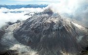
|250px|thumb|right|Image of the [[rhyolitic]] lava dome of [[Chaitén Volcano]] during its 2008–2009 eruption.In volcanology, a lava dome is a roughly circular mound-shaped protrusion resulting from the slow extrusion of viscous lava from a volcano...
s are common features on volcanoes around the world. Lava domes they are known to exisist on plate margins as well as in intra-arc hotspots, and on heights above 6000 m and in the sea floor. Individual lava domes and volcanoes featuring lava domes is shown below.
Afghanistan
| Dome or volcano name | Volcanic area | Composition | Last dome eruption or growth episode |
|---|---|---|---|
| Dacht-i-Navar Group Dacht-i-Navar Group Dacht-i-Navar is a volcanic group of 15 trachyandesitic lava domes located southwest of Kabul, Afghanistan. The lava domes lie along the southern margin of Dacht-i-Navar.Last eruption is Unknown.... |
Ghanzi region | ||
| Vakak Group Vakak Group The Vakak Group is a small volcanic field located WSW of Kabul, Afghanistan. It consists of 18 dacitic and trachytic volcanoes including lava domes and possibly an old caldera.... |
Ghanzi region |
Japan
- Mount KeigetsuMount Keigetsuis located in the Daisetsuzan Volcanic Group of the Ishikari Mountains, Hokkaidō, Japan....
- Mount HokuchinMount Hokuchinis a lava dome located in the Daisetsuzan Volcanic Group of the Ishikari Mountains, Hokkaido, Japan....
- Mount HakuunMount Hakuunis a lava dome located in the Daisetsuzan Volcanic Group of the Ishikari Mountains, Hokkaidō, Japan.-References:*...
- Mount RyōunMount Ryounis a lava dome located in the Daisetsuzan Volcanic Group of the Ishikari Mountains, Hokkaido, Japan....
- Mount KuroMount Kurois a lava dome located in the Daisetsuzan Volcanic Group of the Ishikari Mountains, Hokkaidō, Japan.-Climbing route:The easiest way up the mountain is to use the Daisetsuzan Sōunkyō Kurodake Ropeway up from Sōunkyō. This takes you approximately up the mountain. You can then use a chairlift to...
- Shikaribetsu Volcanic GroupShikaribetsu Volcanic Groupis a volcanic group of lava domes surrounding Lake Shikaribetsu in Hokkaidō, Japan. The Shikaribetsu volcanic group is located in Daisetsuzan National Park...
- Mount TarumaeMount Tarumaeis located in the Shikotsu-Toya National Park in Hokkaidō, Japan. It is located near both Tomakomai and Chitose towns and can be seen clearly from both. It is on the shores of Lake Shikotsu, a caldera lake. Tarumae is a 1,041 metre active andesitic stratovolcano, with a lava dome.-Eruptions:The...
, HokkaidōHokkaido, formerly known as Ezo, Yezo, Yeso, or Yesso, is Japan's second largest island; it is also the largest and northernmost of Japan's 47 prefectural-level subdivisions. The Tsugaru Strait separates Hokkaido from Honshu, although the two islands are connected by the underwater railway Seikan Tunnel... - Mount YokoMount Yoko (Northern Yatsugatake)also Mount Kita Yoko, is an active lava dome located in the Northern Yatsugatake Volcanic Group of the Yatsugatake Mountains, Honshū, Japan. Mount Yoko has shown the most recent activity and is now considered an active volcano. It last erupted about 800 years ago. The eruption consisted of ash with...
France
- Mont Gerbier de JoncMont Gerbier de JoncMont Gerbier de Jonc is a mountain located in the Massif Central in France. It rises to an altitude of 1,551 m , and at its base contains three springs that are the source of the Loire, France's longest river. It is the second most-visited site in the département of Ardèche, after the Ardèche Gorges....
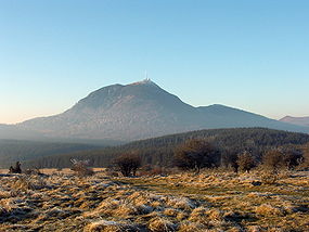
, ArdècheArdècheArdèche is a department in south-central France named after the Ardèche River.- History :The area has been inhabited by humans at least since the Upper Paleolithic, as attested by the famous cave paintings at Chauvet Pont d'Arc. The plateau of the Ardeche River has extensive standing stones ,... - Puy-de-DômePuy-de-Dôme (mountain)Puy de Dôme is a large lava dome and one of the youngest volcanoes in the Chaîne des Puys region of Massif Central in south-central France. This chain of volcanoes including numerous cinder cones, lava domes, and maars is located far from the edge of any tectonic plate. Puy de Dôme is located...
, Clermont-FerrandClermont-FerrandClermont-Ferrand is a city and commune of France, in the Auvergne region, with a population of 140,700 . Its metropolitan area had 409,558 inhabitants at the 1999 census. It is the prefecture of the Puy-de-Dôme department...
Canada
| Dome or volcano name | Volcanic area | Composition | Last dome eruption or growth episode |
|---|---|---|---|
| Atwell Peak Atwell Peak Atwell Peak is a dramatic pyramid shaped volcanic peak located at the southern edge of Mount Garibaldi, British Columbia, Canada. Atwell Peak was formed during an initial period of volcanism 0.51-0.22 million years ago and was the source of many pyroclastic flows during Garibaldi's development.... |
Garibaldi Volcanic Belt Garibaldi Volcanic Belt The Garibaldi Volcanic Belt, also called the Canadian Cascade Arc, is a northwest-southeast trending volcanic chain in the Pacific Ranges of the Coast Mountains that extends from Watts Point in the south to the Ha-Iltzuk Icefield in the north. This chain of volcanoes is located in southwestern... |
Rhyolite Rhyolite This page is about a volcanic rock. For the ghost town see Rhyolite, Nevada, and for the satellite system, see Rhyolite/Aquacade.Rhyolite is an igneous, volcanic rock, of felsic composition . It may have any texture from glassy to aphanitic to porphyritic... |
Pleistocene Pleistocene The Pleistocene is the epoch from 2,588,000 to 11,700 years BP that spans the world's recent period of repeated glaciations. The name pleistocene is derived from the Greek and .... |
| Cartoona Peak Cartoona Peak Cartoona Peak, also unofficially called Cartoona Ridge, is a volcanic peak in northern British Columbia, Canada, located just southeast of Coffee Crater in Mount Edziza Provincial Park.-See also:*List of volcanoes in Canada... |
Northern Cordilleran Volcanic Province Northern Cordilleran volcanic province The Northern Cordilleran Volcanic Province , formerly known as the Stikine Volcanic Belt, is a geologic province defined by the occurrence of Miocene to Holocene volcanoes in the Pacific Northwest of North America... |
Miocene Miocene The Miocene is a geological epoch of the Neogene Period and extends from about . The Miocene was named by Sir Charles Lyell. Its name comes from the Greek words and and means "less recent" because it has 18% fewer modern sea invertebrates than the Pliocene. The Miocene follows the Oligocene... |
|
| Mount Cayley Mount Cayley Mount Cayley is a potentially active stratovolcano in Squamish-Lillooet Regional District of southwestern British Columbia, Canada. Located north of Squamish and west of Whistler in the Pacific Ranges of the Coast Mountains, it rises above the Squamish River to the west and above the Cheakamus... |
Garibaldi Volcanic Belt Garibaldi Volcanic Belt The Garibaldi Volcanic Belt, also called the Canadian Cascade Arc, is a northwest-southeast trending volcanic chain in the Pacific Ranges of the Coast Mountains that extends from Watts Point in the south to the Ha-Iltzuk Icefield in the north. This chain of volcanoes is located in southwestern... |
Dacite Dacite Dacite is an igneous, volcanic rock. It has an aphanitic to porphyritic texture and is intermediate in composition between andesite and rhyolite. The relative proportions of feldspars and quartz in dacite, and in many other volcanic rocks, are illustrated in the QAPF diagram... |
200,000 years ago |
| Ember Ridge Ember Ridge Ember Ridge is a volcanic mountain ridge associated with the Mount Cayley volcanic field in British Columbia, Canada. Ember Ridge is made of a series of steep-sided domes of glassy, complexly jointed, hornblende-phyric basalt with the most recent eruptions during the Holocene... |
Garibaldi Volcanic Belt Garibaldi Volcanic Belt The Garibaldi Volcanic Belt, also called the Canadian Cascade Arc, is a northwest-southeast trending volcanic chain in the Pacific Ranges of the Coast Mountains that extends from Watts Point in the south to the Ha-Iltzuk Icefield in the north. This chain of volcanoes is located in southwestern... |
Andesite Andesite Andesite is an extrusive igneous, volcanic rock, of intermediate composition, with aphanitic to porphyritic texture. In a general sense, it is the intermediate type between basalt and dacite. The mineral assemblage is typically dominated by plagioclase plus pyroxene and/or hornblende. Magnetite,... |
Pleistocene Pleistocene The Pleistocene is the epoch from 2,588,000 to 11,700 years BP that spans the world's recent period of repeated glaciations. The name pleistocene is derived from the Greek and .... -Holocene Holocene The Holocene is a geological epoch which began at the end of the Pleistocene and continues to the present. The Holocene is part of the Quaternary period. Its name comes from the Greek words and , meaning "entirely recent"... |
| Glacier Dome Glacier Dome Glacier Dome is a lava dome in northwestern British Columbia, Canada, located near Mount Edziza in Mount Edziza Provincial Park. It last erupted during the Pleistocene epoch.-See also:*List of volcanoes in Canada*List of Northern Cordilleran volcanoes... |
Northern Cordilleran Volcanic Province Northern Cordilleran volcanic province The Northern Cordilleran Volcanic Province , formerly known as the Stikine Volcanic Belt, is a geologic province defined by the occurrence of Miocene to Holocene volcanoes in the Pacific Northwest of North America... |
Pleistocene Pleistocene The Pleistocene is the epoch from 2,588,000 to 11,700 years BP that spans the world's recent period of repeated glaciations. The name pleistocene is derived from the Greek and .... |
|
| Glacier Pikes Glacier Pikes Glacier Pikes is a Lava dome, located in the Garibaldi Lake volcanic field, British Columbia, Canada. The dome has two rocky points at the southern end of the Sentinel Glacier Neve.-See also:*List of volcanoes in Canada*Volcanism of Canada... |
Garibaldi Volcanic Belt Garibaldi Volcanic Belt The Garibaldi Volcanic Belt, also called the Canadian Cascade Arc, is a northwest-southeast trending volcanic chain in the Pacific Ranges of the Coast Mountains that extends from Watts Point in the south to the Ha-Iltzuk Icefield in the north. This chain of volcanoes is located in southwestern... |
Pleistocene Pleistocene The Pleistocene is the epoch from 2,588,000 to 11,700 years BP that spans the world's recent period of repeated glaciations. The name pleistocene is derived from the Greek and .... |
|
| Heart Peaks Heart Peaks Heart Peaks, originally known as the Heart Mountains, is a mountain massif in the Northern Interior of British Columbia, Canada. It is located northwest of the small community of Telegraph Creek and just southwest of Callison Ranch. With a maximum elevation of , it rises above the surrounding... |
Northern Cordilleran Volcanic Province Northern Cordilleran volcanic province The Northern Cordilleran Volcanic Province , formerly known as the Stikine Volcanic Belt, is a geologic province defined by the occurrence of Miocene to Holocene volcanoes in the Pacific Northwest of North America... |
Rhyolite Rhyolite This page is about a volcanic rock. For the ghost town see Rhyolite, Nevada, and for the satellite system, see Rhyolite/Aquacade.Rhyolite is an igneous, volcanic rock, of felsic composition . It may have any texture from glassy to aphanitic to porphyritic... |
Unknown |
| IGC Centre IGC Centre IGC Centre is a lava dome in Mount Edziza Provincial Park of northern British Columbia, Canada. It is thought to have formed and last erupted during the Miocene period.-See also:*List of volcanoes in Canada*List of Northern Cordilleran volcanoes... |
Northern Cordilleran Volcanic Province Northern Cordilleran volcanic province The Northern Cordilleran Volcanic Province , formerly known as the Stikine Volcanic Belt, is a geologic province defined by the occurrence of Miocene to Holocene volcanoes in the Pacific Northwest of North America... |
Miocene Miocene The Miocene is a geological epoch of the Neogene Period and extends from about . The Miocene was named by Sir Charles Lyell. Its name comes from the Greek words and and means "less recent" because it has 18% fewer modern sea invertebrates than the Pliocene. The Miocene follows the Oligocene... |
|
| Mount Meager Mount Meager Mount Meager, originally known as Meager Mountain, is a complex volcano in the Sea-to-Sky Corridor of southwestern British Columbia, Canada. It is located north of Vancouver at the northern end of the Pemberton Valley. Part of the Cascade Volcanic Arc of western North America, its summit is above... |
Garibaldi Volcanic Belt Garibaldi Volcanic Belt The Garibaldi Volcanic Belt, also called the Canadian Cascade Arc, is a northwest-southeast trending volcanic chain in the Pacific Ranges of the Coast Mountains that extends from Watts Point in the south to the Ha-Iltzuk Icefield in the north. This chain of volcanoes is located in southwestern... |
Dacite Dacite Dacite is an igneous, volcanic rock. It has an aphanitic to porphyritic texture and is intermediate in composition between andesite and rhyolite. The relative proportions of feldspars and quartz in dacite, and in many other volcanic rocks, are illustrated in the QAPF diagram... |
2,350 years ago |
| Mount McNeil Mount McNeil Mount McNeil is a rhyolite lava dome, located 41 km west of Carcross and 7 km south of Mount Skukum, Yukon Territory, Canada. It was formed during the Tertiary eruptions of the Skukum Group.-See also:*List of volcanoes in Canada... |
- | Rhyolite Rhyolite This page is about a volcanic rock. For the ghost town see Rhyolite, Nevada, and for the satellite system, see Rhyolite/Aquacade.Rhyolite is an igneous, volcanic rock, of felsic composition . It may have any texture from glassy to aphanitic to porphyritic... |
Tertiary Tertiary The Tertiary is a deprecated term for a geologic period 65 million to 2.6 million years ago. The Tertiary covered the time span between the superseded Secondary period and the Quaternary... |
| Nanook Dome Nanook Dome Nanook Dome is a lava dome in northwestern British Columbia, Canada, located just northeast of Mount Edziza in Mount Edziza Provincial Park. It last erupted during the Pleistocene epoch.-See also:*List of volcanoes in Canada... |
Northern Cordilleran Volcanic Province Northern Cordilleran volcanic province The Northern Cordilleran Volcanic Province , formerly known as the Stikine Volcanic Belt, is a geologic province defined by the occurrence of Miocene to Holocene volcanoes in the Pacific Northwest of North America... |
- | Pleistocene Pleistocene The Pleistocene is the epoch from 2,588,000 to 11,700 years BP that spans the world's recent period of repeated glaciations. The name pleistocene is derived from the Greek and .... |
| Pharaoh Dome Pharaoh Dome Pharaoh Dome is a lava dome in northwestern British Columbia, Canada, located near Mount Edziza in Mount Edziza Provincial Park. It last erupted during the Pleistocene epoch.-See also:*List of volcanoes in Canada*List of Northern Cordilleran volcanoes... |
Northern Cordilleran Volcanic Province Northern Cordilleran volcanic province The Northern Cordilleran Volcanic Province , formerly known as the Stikine Volcanic Belt, is a geologic province defined by the occurrence of Miocene to Holocene volcanoes in the Pacific Northwest of North America... |
- | Pleistocene Pleistocene The Pleistocene is the epoch from 2,588,000 to 11,700 years BP that spans the world's recent period of repeated glaciations. The name pleistocene is derived from the Greek and .... |
| Sezill Volcano Sezill Volcano Sezill Volcano is a lava dome in Mount Edziza Provincial Park of northern British Columbia, Canada. It is thought to have formed and last erupted during the Miocene period... |
Northern Cordilleran Volcanic Province Northern Cordilleran volcanic province The Northern Cordilleran Volcanic Province , formerly known as the Stikine Volcanic Belt, is a geologic province defined by the occurrence of Miocene to Holocene volcanoes in the Pacific Northwest of North America... |
- | Pleistocene Pleistocene The Pleistocene is the epoch from 2,588,000 to 11,700 years BP that spans the world's recent period of repeated glaciations. The name pleistocene is derived from the Greek and .... |
| Mount Silverthrone Mount Silverthrone Mount Silverthrone, officially named Silverthrone Mountain, is a mountain in the Regional District of Mount Waddington, British Columbia, located over northwest of the city of Vancouver and about west of Mount Waddington, British Columbia, Canada... |
Garibaldi Volcanic Belt Garibaldi Volcanic Belt The Garibaldi Volcanic Belt, also called the Canadian Cascade Arc, is a northwest-southeast trending volcanic chain in the Pacific Ranges of the Coast Mountains that extends from Watts Point in the south to the Ha-Iltzuk Icefield in the north. This chain of volcanoes is located in southwestern... |
- | Holocene Holocene The Holocene is a geological epoch which began at the end of the Pleistocene and continues to the present. The Holocene is part of the Quaternary period. Its name comes from the Greek words and , meaning "entirely recent"... |
| Spectrum Dome Spectrum Dome Spectrum Dome is a lava dome in the Spectrum Range of northwestern British Columbia, Canada. It last erupted during the Pliocene epoch.-See also:*List of volcanoes in Canada*List of Northern Cordilleran volcanoes*Volcanism of Canada... |
Northern Cordilleran Volcanic Province Northern Cordilleran volcanic province The Northern Cordilleran Volcanic Province , formerly known as the Stikine Volcanic Belt, is a geologic province defined by the occurrence of Miocene to Holocene volcanoes in the Pacific Northwest of North America... |
- | Pliocene Pliocene The Pliocene Epoch is the period in the geologic timescale that extends from 5.332 million to 2.588 million years before present. It is the second and youngest epoch of the Neogene Period in the Cenozoic Era. The Pliocene follows the Miocene Epoch and is followed by the Pleistocene Epoch... |
| Sphinx Dome Sphinx Dome Sphinx Dome is a lava dome in northwestern British Columbia, Canada, located near Mount Edziza in Mount Edziza Provincial Park. It last erupted during the Pleistocene epoch.-See also:*List of volcanoes in Canada*List of Northern Cordilleran volcanoes... |
Northern Cordilleran Volcanic Province Northern Cordilleran volcanic province The Northern Cordilleran Volcanic Province , formerly known as the Stikine Volcanic Belt, is a geologic province defined by the occurrence of Miocene to Holocene volcanoes in the Pacific Northwest of North America... |
- | Pleistocene Pleistocene The Pleistocene is the epoch from 2,588,000 to 11,700 years BP that spans the world's recent period of repeated glaciations. The name pleistocene is derived from the Greek and .... |
| Sturgeon Lake Caldera Sturgeon Lake Caldera Sturgeon Lake Caldera is a large extinct caldera complex in Kenora District of Northwestern Ontario, Canada. It is one the world's best preserved mineralized Neoarchean caldera complexes, containing well-preserved mafic-intermediate pillow lavas, pillow breccias, hyaloclastite and peperites,... |
Wabigoon greenstone belt | - | Neoarchean Neoarchean The Neoarchean is a geologic era within the Archaean. It spans the period of time from —the period being defined chronometrically and not referenced to a specific level in a rock section on Earth... |
| Tadeda Peak Tadeda Peak Tadeda Peak, also known unofficially as Tadeda Centre, is a volcanic peak in northern British Columbia, Canada, located just southeast of Coffee Crater in Mount Edziza Provincial Park.-See also:* List of volcanoes in Canada... |
Northern Cordilleran Volcanic Province Northern Cordilleran volcanic province The Northern Cordilleran Volcanic Province , formerly known as the Stikine Volcanic Belt, is a geologic province defined by the occurrence of Miocene to Holocene volcanoes in the Pacific Northwest of North America... |
- | Miocene Miocene The Miocene is a geological epoch of the Neogene Period and extends from about . The Miocene was named by Sir Charles Lyell. Its name comes from the Greek words and and means "less recent" because it has 18% fewer modern sea invertebrates than the Pliocene. The Miocene follows the Oligocene... |
| The Pyramid | Northern Cordilleran Volcanic Province Northern Cordilleran volcanic province The Northern Cordilleran Volcanic Province , formerly known as the Stikine Volcanic Belt, is a geologic province defined by the occurrence of Miocene to Holocene volcanoes in the Pacific Northwest of North America... |
- | Pleistocene Pleistocene The Pleistocene is the epoch from 2,588,000 to 11,700 years BP that spans the world's recent period of repeated glaciations. The name pleistocene is derived from the Greek and .... |
| Triangle Dome Triangle Dome Triangle Dome is a trachytic lava dome in northern British Columbia, Canada. It is thought to have formed in the Pleistocene period.-See also:*List of volcanoes in Canada*List of Northern Cordilleran volcanoes*Volcanism of Canada... |
Northern Cordilleran Volcanic Province Northern Cordilleran volcanic province The Northern Cordilleran Volcanic Province , formerly known as the Stikine Volcanic Belt, is a geologic province defined by the occurrence of Miocene to Holocene volcanoes in the Pacific Northwest of North America... |
- | Pleistocene Pleistocene The Pleistocene is the epoch from 2,588,000 to 11,700 years BP that spans the world's recent period of repeated glaciations. The name pleistocene is derived from the Greek and .... |
United States
- Augustine VolcanoAugustine VolcanoAugustine Volcano is a Lava Dome Complex on Augustine Island in southwestern Cook Inlet in the Kenai Peninsula Borough of southcentral coastal Alaska, southwest of Anchorage. The Alaska Volcano Observatory currently rates Mount Augustine as Level of Concern Color Code Green for aviation and the...
, Cook InletCook InletCook Inlet stretches from the Gulf of Alaska to Anchorage in south-central Alaska. Cook Inlet branches into the Knik Arm and Turnagain Arm at its northern end, almost surrounding Anchorage....
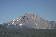
, AlaskaAlaskaAlaska is the largest state in the United States by area. It is situated in the northwest extremity of the North American continent, with Canada to the east, the Arctic Ocean to the north, and the Pacific Ocean to the west and south, with Russia further west across the Bering Strait... - Lassen PeakLassen PeakLassen Peak is the southernmost active volcano in the Cascade Range. It is part of the Cascade Volcanic Arc which is an arc that stretches from northern California to southwestern British Columbia...
, Shasta County, CaliforniaShasta County, CaliforniaShasta County is a county located in the northern portion of the U.S. state of California. The county occupies the northern reaches of the Sacramento Valley, with portions extending into the southern reaches of the Cascade Range. As of the 2010 census, the population was 177,223, up from 163,256... - Mono-Inyo CratersMono-Inyo CratersThe Mono–Inyo Craters is a volcanic chain of craters, domes and lava flows in Eastern California that stretches from the northwest shore of Mono Lake to the south of Mammoth Mountain. The chain is located in Mono County in the U.S. state of California...
, CaliforniaCaliforniaCalifornia is a state located on the West Coast of the United States. It is by far the most populous U.S. state, and the third-largest by land area... - Panum CraterPanum CraterPanum Crater is a volcanic cone that is part of the Mono-Inyo Craters, a chain of recent volcanic cones south of Mono Lake and east of the Sierra Nevada, in California, USA...
, CaliforniaCaliforniaCalifornia is a state located on the West Coast of the United States. It is by far the most populous U.S. state, and the third-largest by land area... - Newberry VolcanoNewberry VolcanoNewberry Volcano is a large potentially active shield volcano located east of the Cascade Range and about southeast of Bend, Oregon. It is not a typical shield volcano. In addition to erupting basaltic lavas, it also has erupted andesitic and even rhyolitic lava.The volcano is in diameter and...
, OregonOregonOregon is a state in the Pacific Northwest region of the United States. It is located on the Pacific coast, with Washington to the north, California to the south, Nevada on the southeast and Idaho to the east. The Columbia and Snake rivers delineate much of Oregon's northern and eastern... - West CraterWest CraterWest Crater is a small andesitic lava dome with associated lava flows in southern Washington, USA....
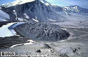
, Washington - NovaruptaNovaruptaNovarupta, meaning "new eruption", is a volcano located on the Alaska Peninsula in Katmai National Park and Preserve, about southwest of Anchorage. Formed in 1912 during the largest volcanic eruption of the 20th century, Novarupta released 30 times the volume of magma as the 1980 eruption of...
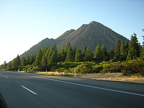
, AlaskaAlaskaAlaska is the largest state in the United States by area. It is situated in the northwest extremity of the North American continent, with Canada to the east, the Arctic Ocean to the north, and the Pacific Ocean to the west and south, with Russia further west across the Bering Strait... - Black ButteBlack Butte (Siskiyou County, California)Black Butte is a cluster of overlapping dacite lava domes in a butte,a parasitic satellite cone of Mount Shasta. It is located directly adjacent to Interstate 5 at milepost 742 between the city of Mount Shasta and Weed, California. The highway crosses a pass, Black Butte Summit, at the western...
, Siskiyou CountySiskiyou County, CaliforniaSiskiyou County is a county located in the far northernmost part of the U.S. state of California, in the Shasta Cascade region on the Oregon border. Yreka is the county seat. Because of its substantial natural beauty, outdoor recreation opportunities, and Gold Rush era history, it is an important... - Chaos CragsChaos CragsChaos Crags is the youngest group of lava domes in Lassen Volcanic National Park, California, having been formed as five dacite domes 1,100-1,000 years ago...
- Coso Volcanic FieldCoso Volcanic FieldThe Coso Volcanic Field is located in Inyo County, California, at the western edge of the Basin and Range geologic province and northern region of the Mojave Desert. The Fossil Falls are part of the Coso Field, created by the prehistoric Owens River. They are currently within the Naval Air Weapons...
- Mammoth MountainMammoth MountainMammoth Mountain is a lava dome complex west of the town of Mammoth Lakes, California in the Inyo National Forest of Madera County and Mono County. It is home to a large ski area on the Mono County side....
, Inyo National ForestInyo National ForestInyo National Forest is a federally administered forest in the United States. The forest covers parts of the eastern Sierra Nevada of California, and the White Mountains of California and Nevada. It contains two wilderness areas: the John Muir Wilderness and the Ansel Adams Wilderness... - Sutter ButtesSutter ButtesThe Sutter Buttes are a small circular complex of eroded volcanic lava domes which rise as buttes above the flat plains of the Central Valley of California in the United States. The highest peak, South Butte, reaches about above sea level. The Buttes are located just outside of Yuba City,...
, Sacramento ValleySacramento ValleyThe Sacramento Valley is the portion of the California Central Valley that lies to the north of the San Joaquin-Sacramento Delta in the U.S. state of California. It encompasses all or parts of ten counties.-Geography:... - Big Southern ButteBig Southern ButteBig Southern Butte is the largest and youngest of three rhyolitic domes formed over a million years near the center of the Eastern Snake River Plain in the U.S. state of Idaho. In fact, it is one of the largest volcanic domes on earth...
, Butte County, IdahoButte County, IdahoButte County is a rural county located in the U.S. state of Idaho. It was established in 1917, and its county seat and largest city is Arco. As of the 2010 census, the county had a population of 2,891... - Cinnamon ButteCinnamon ButteCinnamon Butte is a group of cinder cone volcanoes and lava domes in the Cascade Range of Oregon. All of the vents are older than approximately 6,845 years as they are all covered in ash from the eruption of Mount Mazama.-Notable Vents:...
, OregonOregonOregon is a state in the Pacific Northwest region of the United States. It is located on the Pacific coast, with Washington to the north, California to the south, Nevada on the southeast and Idaho to the east. The Columbia and Snake rivers delineate much of Oregon's northern and eastern... - Marble Mountain-Trout Creek HillMarble Mountain-Trout Creek HillMarble Mountain-Trout Creek Hill volcanic field is a volcanic field located in Washington, USA.-Notable Vents:-Trout Creek Hill:Trout Creek Hill is a small Pleistocene basaltic shield volcano in Washington, United States...
, Washington - Mount EldenMount EldenMount Elden, or Elden Mountain, is located in central Coconino County northeast of Flagstaff, Arizona. It takes its name from one of the region's earliest Anglo settlers, John Elden, who, along with his family, established a homestead on the mountain’s lower slopes and grazed sheep on the open...
, Coconino County, ArizonaCoconino County, Arizona-2010:Whereas according to the 2010 U.S. Census Bureau:*61.7% White*1.2% Black*27.3% Native American*1.4% Asian*0.1% Native Hawaiian or Pacific Islander*3.1% Two or more races*5.2% Other races*13.5% Hispanic or Latino -2000:... - Steamboat SpringsSteamboat Springs, NevadaSteamboat Springs is a small volcanic field of rhyolitic lava domes and flows in western Nevada, USA, located south of Reno. There is extensive geothermal activity in the area, including numerous hot springs, steam vents, and fumaroles...
, Washoe County, NevadaWashoe County, NevadaWashoe County is a county located in the U.S. state of Nevada. The population was 421,407 at the 2010 census. Its county seat is Reno. Washoe County includes the Reno-Sparks metropolitan area.-History:...
Argentina
| Dome or volcano name | Volcanic area | Composition | Last dome eruption or growth episode |
|---|---|---|---|
| Tipas Tipas Cerro Tipas is a massive complex volcano in northwestern Argentina, located just southwest of Ojos del Salado, the highest volcano in the world. Tipas itself is perhaps the third highest active volcano in the world, and it consists of stratovolcanoes, lava domes, and lava flows.-Source:*... |
Central Volcanic Zone | ||
| Trocon Trocon Trocon is a lava dome complex in Argentina. It has two summit craters and a pyroclastic cone. It is of estimated Pleistocene-Holocene age.-References:*... |
Southern Volcanic Zone | Andesite Andesite Andesite is an extrusive igneous, volcanic rock, of intermediate composition, with aphanitic to porphyritic texture. In a general sense, it is the intermediate type between basalt and dacite. The mineral assemblage is typically dominated by plagioclase plus pyroxene and/or hornblende. Magnetite,... to Dacite Dacite Dacite is an igneous, volcanic rock. It has an aphanitic to porphyritic texture and is intermediate in composition between andesite and rhyolite. The relative proportions of feldspars and quartz in dacite, and in many other volcanic rocks, are illustrated in the QAPF diagram... |
Chile
| Dome or volcano name | Volcanic area | Composition | Last dome eruption or growth episode |
|---|---|---|---|
| Cerros de Saltar | Central Volcanic Zone | Dacite Dacite Dacite is an igneous, volcanic rock. It has an aphanitic to porphyritic texture and is intermediate in composition between andesite and rhyolite. The relative proportions of feldspars and quartz in dacite, and in many other volcanic rocks, are illustrated in the QAPF diagram... |
Pliocene Pliocene The Pliocene Epoch is the period in the geologic timescale that extends from 5.332 million to 2.588 million years before present. It is the second and youngest epoch of the Neogene Period in the Cenozoic Era. The Pliocene follows the Miocene Epoch and is followed by the Pleistocene Epoch... |
| Chaitén | Southern Volcanic Zone | Rhyolite Rhyolite This page is about a volcanic rock. For the ghost town see Rhyolite, Nevada, and for the satellite system, see Rhyolite/Aquacade.Rhyolite is an igneous, volcanic rock, of felsic composition . It may have any texture from glassy to aphanitic to porphyritic... |
2010 |
| Corona Dome Complex | Central Volcanic Zone | Andesite Andesite Andesite is an extrusive igneous, volcanic rock, of intermediate composition, with aphanitic to porphyritic texture. In a general sense, it is the intermediate type between basalt and dacite. The mineral assemblage is typically dominated by plagioclase plus pyroxene and/or hornblende. Magnetite,... |
Quaternary Quaternary The Quaternary Period is the most recent of the three periods of the Cenozoic Era in the geologic time scale of the ICS. It follows the Neogene Period, spanning 2.588 ± 0.005 million years ago to the present... |
| Cordón Caulle Puyehue-Cordón Caulle Puyehue and Cordón Caulle are two coalesced volcanic edifices that form a major mountain massif in Puyehue National Park in the Andes of Ranco Province, Chile. In volcanology this group is known as the Puyehue-Cordón Caulle Volcanic Complex... |
Southern Volcanic Zone | Rhyodacite Rhyodacite Rhyodacite is an extrusive volcanic rock intermediate in composition between dacite and rhyolite. It is the extrusive equivalent of granodiorite. Phenocrysts of sodium rich plagioclase, sanidine, quartz, and biotite or hornblende are typically set in an aphanitic to glassy light to intermediate... to Rhyolite Rhyolite This page is about a volcanic rock. For the ghost town see Rhyolite, Nevada, and for the satellite system, see Rhyolite/Aquacade.Rhyolite is an igneous, volcanic rock, of felsic composition . It may have any texture from glassy to aphanitic to porphyritic... |
Holocene Holocene The Holocene is a geological epoch which began at the end of the Pleistocene and continues to the present. The Holocene is part of the Quaternary period. Its name comes from the Greek words and , meaning "entirely recent"... |
| Fueguino Fueguino Fueguino, also known as Cook, is a cluster of lava domes and pyroclastic cones located on Cook Island, Tierra del Fuego, Chile. This volcanic group lies south of the Magallanes-Fagnano Fault, on the Scotia Plate.... |
Austral Volcanic Zone | Holocene Holocene The Holocene is a geological epoch which began at the end of the Pleistocene and continues to the present. The Holocene is part of the Quaternary period. Its name comes from the Greek words and , meaning "entirely recent"... |
|
| Lascar Lascar Volcano -Geographical setting:Lascar is located in the altiplano of the Antofagasta Region of northern Chile, east of the Salar de Atacama, immediately west of the Aguas Calientes volcano, and to the northeast of Laguna Lejía... |
Central Volcanic Zone | Dacite Dacite Dacite is an igneous, volcanic rock. It has an aphanitic to porphyritic texture and is intermediate in composition between andesite and rhyolite. The relative proportions of feldspars and quartz in dacite, and in many other volcanic rocks, are illustrated in the QAPF diagram... |
2007 |
| Volcán Nuevo Nevados de Chillán Nevados de Chillán is a group of stratovolcanoes located in the Andes of the Bío-Bío Region, Chile, and is one of the most active volcanoes in the region. It consists of three overlapping peaks, Cerro Blanco at the northwest and Volcán Viejo at the southeast, with Volcán Nuevo in the middle... |
Southern Volcanic Zone | Dacite Dacite Dacite is an igneous, volcanic rock. It has an aphanitic to porphyritic texture and is intermediate in composition between andesite and rhyolite. The relative proportions of feldspars and quartz in dacite, and in many other volcanic rocks, are illustrated in the QAPF diagram... |
1986 |
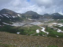
| Sollipulli Sollipulli thumb|right|Nevados de Sollipulli as seen from [[Villarrica |Villarrica Volcano]]Sollipulli is an ice-filled volcanic caldera, which lies about 12 kilometres south of the small town of Melipeuco in the Araucanía Region, Chile... |
Southern Volcanic Zone | Andesite Andesite Andesite is an extrusive igneous, volcanic rock, of intermediate composition, with aphanitic to porphyritic texture. In a general sense, it is the intermediate type between basalt and dacite. The mineral assemblage is typically dominated by plagioclase plus pyroxene and/or hornblende. Magnetite,... to Dacite Dacite Dacite is an igneous, volcanic rock. It has an aphanitic to porphyritic texture and is intermediate in composition between andesite and rhyolite. The relative proportions of feldspars and quartz in dacite, and in many other volcanic rocks, are illustrated in the QAPF diagram... |
|
| Taapaca Taapaca Taapaca, is part of the Nevados de Putre volcanic complex. It is a complex volcano located in Chile's XV region of Tarapaca, and towers over the picturesque town of Putre.... |
Central Volcanic Zone | Holocene Holocene The Holocene is a geological epoch which began at the end of the Pleistocene and continues to the present. The Holocene is part of the Quaternary period. Its name comes from the Greek words and , meaning "entirely recent"... |
New Zealand
- Ben LomondBen Lomond, WaikatoBen Lomond is a rhyolite lava dome near Lake Taupo in New Zealand's North Island. Located about eight kilometres north-northeast of Kinloch, it rises to a height of 744 metres above sea level....
, North IslandNorth IslandThe North Island is one of the two main islands of New Zealand, separated from the much less populous South Island by Cook Strait. The island is in area, making it the world's 14th-largest island... - Mount TaraweraMount TaraweraMount Tarawera is the volcano responsible for New Zealand's largest historic eruption. Located 24 kilometres southeast of Rotorua in the North Island, it consists of a series of rhyolitic lava domes that were fissured down the middle by an explosive basaltic eruption in 1886, which killed over...
, North IslandNorth IslandThe North Island is one of the two main islands of New Zealand, separated from the much less populous South Island by Cook Strait. The island is in area, making it the world's 14th-largest island...
Extraterrestrial lava domes
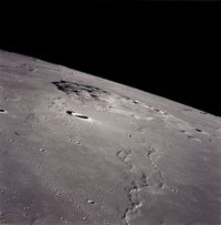
- Mons RümkerMons RümkerMons Rümker is an isolated volcanic formation that is located in the northwest part of the Moon's near side, at selenographic coordinates 40.8° N, 58.1° W. The feature forms a large, elevated mound in the northern part of the Oceanus Procellarum. The mound has a diameter of 70 kilometres, and...
, near side of the moonMoonThe Moon is Earth's only known natural satellite,There are a number of near-Earth asteroids including 3753 Cruithne that are co-orbital with Earth: their orbits bring them close to Earth for periods of time but then alter in the long term . These are quasi-satellites and not true moons. For more...
See also
- List of stratovolcanoes
- List of shield volcanoes
- List of cinder cones
- List of currently erupting volcanoes