
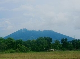
Mount Arayat
Encyclopedia
Stratovolcano
A stratovolcano, also known as a composite volcano, is a tall, conical volcano built up by many layers of hardened lava, tephra, pumice, and volcanic ash. Unlike shield volcanoes, stratovolcanoes are characterized by a steep profile and periodic, explosive eruptions...
on Luzon Island, Philippines
Philippines
The Philippines , officially known as the Republic of the Philippines , is a country in Southeast Asia in the western Pacific Ocean. To its north across the Luzon Strait lies Taiwan. West across the South China Sea sits Vietnam...
, rising to a height of 1026 metres (3,366 ft) There is no recorded eruption of the volcano, and its last activity probably dates to the Holocene
Holocene
The Holocene is a geological epoch which began at the end of the Pleistocene and continues to the present. The Holocene is part of the Quaternary period. Its name comes from the Greek words and , meaning "entirely recent"...
era.
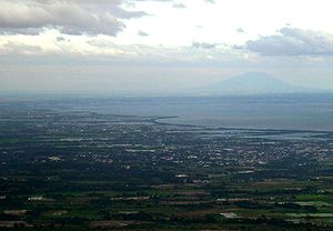
The volcano is located in a flat agricultural region at 15°12′N 120°45′E. The southern half of the mountain lies within the municipality of Arayat, Pampanga
Arayat, Pampanga
Arayat is a 1st class municipality in the province of Pampanga, Philippines. According to the latest census, it has a population of 118,312 people in 18,571 households. Mount Arayat is located within this municipality.-Barangays:...
, while the north half and the mountain summit lies within Magalang, Pampanga
Magalang, Pampanga
Magalang is a 1st class municipality in the province of Pampanga, Philippines. According to the latest census, it has a population of 98,595 people in 15,257 households.-Barangays:Magalang is politically subdivided into 27 barangays.* Camias* Dolores...
. Ten miles to the west of Mount Arayat is Angeles City
Angeles City
The City of Angeles , located within the province of Pampanga in the Philippines, is locally classified as a first-class, highly-urbanized city. Its name is derived from El Pueblo de los Ángeles in honor of its patron saints, Los Santos Ángeles de los Custodios , and the name of its founder, Don...
and the former Clark Air Base
Clark Air Base
Clark Air Base is a former United States Air Force base on Luzon Island in the Philippines, located 3 miles west of Angeles City, about 40 miles northwest of Metro Manila. Clark Air Base was an American military facility from 1903 to 1991...
. Mount Pinatubo
Mount Pinatubo
Mount Pinatubo is an active stratovolcano located on the island of Luzon, near the tripoint of the Philippine provinces of Zambales, Tarlac, and Pampanga. It is located in the Tri-Cabusilan Mountain range separating the west coast of Luzon from the central plains, and is west of the dormant and...
is located a further 16 km (10 mi) west. The Volcano is a popular Tourist destination for people visiting the central plains.
It is considered a mystical mountain, the legendary home of Aung/Aring Sinukuan/Sinkuan/Suku or the Fairy known as diwata
Diwata
In Philippine mythology, a Diwata , also known as Encantada, is a mythological figure similar to fairies or nymphs. They are nature spirits and live one with mother earth...
Mariang Sinukuan
Maria Sinukuan
Maria Sinukuan is the diwata or mountain goddess associated with Mount Arayat in Pampanga, Philippines, similar to Maria Makiling of Los Baños and Maria Cacao of Cebu.-Basic legend:...
depending on which version of the story the readers or listeners prefer, but in ancient Kapampangan folklore as well as the research known to have been gathered by Kapampangan students of Henry Otley Beyer, it was and is the abode of Apung/Aring Sinukuan, rival of Namalyari of Mount Pinatubo
Mount Pinatubo
Mount Pinatubo is an active stratovolcano located on the island of Luzon, near the tripoint of the Philippine provinces of Zambales, Tarlac, and Pampanga. It is located in the Tri-Cabusilan Mountain range separating the west coast of Luzon from the central plains, and is west of the dormant and...
, who is in varying versions, the son of Cargon-Cargon who was mortally wounded in a fight with a giant from the Zambales Mountain Range which is said to be the home of Apu Namalyari.
Geography
Mount Arayat stands in the middle of the flat Central Luzon Plain, consisting of rice paddies and a typical elevation of about 15 to 30 metres MSL. The mountain is topped by a circular volcanic craterVolcanic crater
A volcanic crater is a circular depression in the ground caused by volcanic activity. It is typically a basin, circular in form within which occurs a vent from which magma erupts as gases, lava, and ejecta. A crater can be of large dimensions, and sometimes of great depth...
about 1.2 km in diameter, much of which has collapsed on the western and part of the northern rim due to erosion. This has resulted in a breached crater which opens in a west-northwest direction. This area is the apparent source of a major debris-avalanche deposit that forms hummocky terrain beyond the west and northwest sides of the volcano. The 1026-metre summit stands on the northeast side of the breached crater, known as North Peak, while the 984-metre Pinnacle Peak is located on the southeast crater rim. Post-collapse activity formed an andesitic dome known as White Rock in the collapse amphitheater.
Eruptions
There are no cultural records of historical eruptions. However, weak steaming is currently present in some of the heavily eroded vents on the North Western side of the summit. The ancient eruptions were said to have caused the formation of a Lava Dome on the Western Slopes of the mountain known as White Rock which makes a nice tourist destination and is usually a field trip destination for students of Pampanga Agricultural College. The Arayat ampitheatre is said to have been caused by the summit's collapse on the western side but a much deeper crater is present on the eastern side, it was said that the mountain was once a volcanic island, until eruptions covered the surrounding area with soil, eruptions were said to be the possible cause of a theorized re-route of Pampanga RiverPampanga River
Pampanga River is the second largest river in the island of Luzon, next to Cagayan River and the third largest river in the Philippines...
which is said to have once passed on the western side rather than eastern side where it currently moves.
Geology
Rock types are basaltBasalt
Basalt is a common extrusive volcanic rock. It is usually grey to black and fine-grained due to rapid cooling of lava at the surface of a planet. It may be porphyritic containing larger crystals in a fine matrix, or vesicular, or frothy scoria. Unweathered basalt is black or grey...
and andesite
Andesite
Andesite is an extrusive igneous, volcanic rock, of intermediate composition, with aphanitic to porphyritic texture. In a general sense, it is the intermediate type between basalt and dacite. The mineral assemblage is typically dominated by plagioclase plus pyroxene and/or hornblende. Magnetite,...
. The only rocks reported to have been dated are 0.53 and 0.65 million-year-old basalts. These predate the crater collapse and formation of the lava dome known as White Rock, which could have occurred in the last 2000 years.
The mountain which is believed to be several peaks merged at the top by some local people is actually a Single-Cone Stratovolcano
Stratovolcano
A stratovolcano, also known as a composite volcano, is a tall, conical volcano built up by many layers of hardened lava, tephra, pumice, and volcanic ash. Unlike shield volcanoes, stratovolcanoes are characterized by a steep profile and periodic, explosive eruptions...
.
Hiking activity
Two trails lead to the peaks of Mount Arayat. Mount Arayat National Park Located at San Juan Baño in Arayat, PampangaArayat, Pampanga
Arayat is a 1st class municipality in the province of Pampanga, Philippines. According to the latest census, it has a population of 118,312 people in 18,571 households. Mount Arayat is located within this municipality.-Barangays:...
has a trail to the southern Peak, taking around 3–4 hours to reach the peak. The Southern Peak offers views of Central Luzon, including a view of Pampanga River
Pampanga River
Pampanga River is the second largest river in the island of Luzon, next to Cagayan River and the third largest river in the Philippines...
. The collapsed western Slope that forms the other half of its Caldera like crater can also be seen. It offers a view of the mountains of Zambales
Zambales
Zambales is a province of the Philippines located in the Central Luzon region. Its capital is Iba. Zambales borders Pangasinan to the north, Tarlac and Pampanga to the east, and Bataan to the south. The province lies between the South China Sea and the Zambales Mountains. With a land area of...
and Bataan
Bataan
Bataan is a province of the Philippines occupying the whole of the Bataan Peninsula on Luzon. The province is part of the Central Luzon region. The capital of Bataan is Balanga City and it is bordered by the provinces of Zambales and Pampanga to the north...
(to the west), and the mountains of the Sierra Madre range (to the east). The northern or higher Peak can be accessed on a route from Pampanga Agricultural College in Magalang, Pampanga
Magalang, Pampanga
Magalang is a 1st class municipality in the province of Pampanga, Philippines. According to the latest census, it has a population of 98,595 people in 15,257 households.-Barangays:Magalang is politically subdivided into 27 barangays.* Camias* Dolores...
, taking a similar time to reach the peak, however, this route takes you through the Arayat Ampitheatre and the so-called White Rock which legend claims to be the Home of Apung/Aring Sinukuan or Sinukuan.
Arayat in Folklore
The Mountain is said to be the home of the god/sorcerer named Sinukuan/Sinukwan or Sucu, which could mean "The end" or "he who others have surrendered to." The mountain was said to have been located in the swamp to its south but relocated because of the evil ways of those who lived there, in addition to which, the people of the swamp were made to suffer numerous misfortunes. Sinukuan is believed to be able to transform and do as he pleases at will, his only real rival being Namalyari of Mount PinatuboMount Pinatubo
Mount Pinatubo is an active stratovolcano located on the island of Luzon, near the tripoint of the Philippine provinces of Zambales, Tarlac, and Pampanga. It is located in the Tri-Cabusilan Mountain range separating the west coast of Luzon from the central plains, and is west of the dormant and...
. The waterfalls at Ayala in Magalang, Pampanga
Magalang, Pampanga
Magalang is a 1st class municipality in the province of Pampanga, Philippines. According to the latest census, it has a population of 98,595 people in 15,257 households.-Barangays:Magalang is politically subdivided into 27 barangays.* Camias* Dolores...
is said to be his bathing quarters, and it is often visited by tourists and natives alike. Sinukuan is said to live at the White rock, a Lava dome possibly formed by the last eruption, where its glimmering properties were most likely to have inspired the legend. Contrary to reality, the mountain is believed to be several mountains merging at the center including the tallest two peaks.
In other legends, Sinukuan is said to have bested Makiling of southern Luzon almost effortlessly unlike his arch rival Namalyari.
Sinukuan is believed to have daughters who come down only during time of grace and are disguised as humans, Sinukuan himself can be disguised as human. The day he comes back is believed to either be when he responds to the attack of Namalyari on Mount Pinatubo's 1991 eruption or when the time to call his servants upon the end of the world has come.
Listings
FumaroleFumarole
A fumarole is an opening in a planet's crust, often in the neighborhood of volcanoes, which emits steam and gases such as carbon dioxide, sulfur dioxide, hydrochloric acid, and hydrogen sulfide. The steam is created when superheated water turns to steam as its pressure drops when it emerges from...
activity is reported on the NW side of the summit.
The Global Volcanism Program
Global Volcanism Program
The Smithsonian Institution's Global Volcanism Program documents Earth's volcanoes and their eruptive history over the past 10,000 years. The GVP reports on current eruptions from around the world as well as maintaining a database repository on active volcanoes and their eruptions. In this way, a...
lists Mount Arayat as Holocene?
Philippine Institute of Volcanology and Seismology
Philippine Institute of Volcanology and Seismology
The Philippine Institute of Volcanology and Seismology is a Philippine national institution dedicated to provide information on the activities of volcanoes, earthquakes and tsunamis, as well as other specialized information and services primarily for the protection of life and property and in...
(PHIVOLCS), list Mount Arayat as Inactive.
See also
- Active volcanos in the Philippines
- Potentially active volcanos in the Philippines
- Inactive volcanos in the Philippines
- Pacific ring of firePacific Ring of FireThe Pacific Ring of Fire is an area where large numbers of earthquakes and volcanic eruptions occur in the basin of the Pacific Ocean. In a horseshoe shape, it is associated with a nearly continuous series of oceanic trenches, volcanic arcs, and volcanic belts and/or plate movements...