
Cumbre Vieja
Encyclopedia
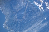
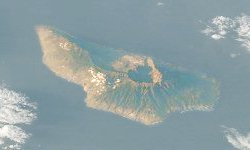
Cumbre Vieja is an active volcanic
ridge on the volcanic ocean island of Isla de La Palma
in the Canary Islands
.
This ridge trends in an approximate north-south direction and covers the southern third of the island. It is lined by several volcanic craters.
was erupted. Also during the eruption two earthquake
s occurred with epicentres
near Jedey. Following the earthquakes a fracture approximately two and half kilometres long, about 1/10 of the exposed length of the Cumbre Vieja, opened and parts of the western half of the Cumbre Vieja ridge moved about 1 metre sideways and 2 metres downwards towards the Atlantic Ocean
. As of 2008, the fracture is still visible and still has the same dimensions recorded in 1949.
It is considered that this process was driven by the pressure caused by the rising magma
super-heating water trapped within the edifice of the volcano. It is unlikely that the trapped waters could vapourise due to being under considerable pressure. What is postulated is that the waters were heated to a point where they could not absorb further thermal energy
in the available space. Continuing heating required the water to expand further and the only way it could do so was to move the flank of the volcano. This resulted in the two earthquakes that were reported as occurring during the eruption.
That the water did not vapourise is shown by the absence of phreatomagmatic explosions: steam escaping explosively from the ground is often a precursor of volcanic activity. Further evidence that vapourisation did not occur is that when Rubio Bonelli visited the rift the following day, the newly opened fissure "... Was not issuing fumes, vapor, steam, ashes, lava or other materials ..." In fact at no time during or after was steam or phreatomagmatic activity reported. This reinforces the claim that the waters trapped within the edifice never vapourised, which they would do if the pressure had fallen sufficiently to allow the super-heated water to flash into steam.
was also erupted. Such seismic activity did not occur during the 1949 eruption. Residual thermal activity continues.
 In October 2000, the BBC
transmitted “Mega-tsunami; Wave of Destruction”, which suggested that a future failure of the western flank of the Cumbre Vieja would cause a "mega-tsunami
".
Day et al. (1999) and Ward and Day (2001) hypothesise that during an eruption at some unascertained future time, the western half of the Cumbre Vieja—approximately 500 km3 (5 x 10¹¹ m3) with an estimated mass of 1.5 x 10¹⁵ kg—will catastrophically fail in a massive gravitational landslide and enter the Atlantic Ocean
, generating a so called 'mega-tsunami'. The debris will continue to travel along the ocean floor as a debris flow
. Computer modelling indicates that the resulting initial wave may attain a local amplitude (height) in excess of 600 metres (1,969 ft) and an initial peak to peak height that approximates to 2 kilometres (1 mi), and travel at about 1000 kilometres per hour (621 mph) (approximately the speed of a jet aircraft
), inundating the Africa
n coast in about 1 hour, the southern coast of England
in about 3.5 hours, and the eastern seaboard
of North America
in about 6 hours, by which time the initial wave will have subsided into a succession of smaller ones each about 30 metres (98 ft) to 60 metres (197 ft) high. These may surge to several hundred metres in height and be several kilometres apart while retaining their original speed. The models of Day et al. and Ward and Day suggest that the event could inundate up to 25 kilometres (16 mi) inland. This would greatly damage or destroy cities along the entire North American eastern seaboard, and tens of millions would be killed as Boston
, New York City
, Miami, and many other cities located near the Atlantic coast are leveled.
Detailed geological mapping shows that the distribution and orientation of vents and feeder dykes within the volcano
have shifted from a triple rift system (typical of most oceanic island volcanoes) to one consisting of a single north-south rift. It is claimed that this structural reorganisation is a response to evolving stress patterns associated with the development of a possible detachment fault under the volcano's west flank. Siebert (1984) showed that such failures are due to the intrusion of parallel and sub-parallel dykes into a rift. Eventually the structure becomes unstable and catastrophic failure occurs. There is no evidence that the 1949 section of the rift extends in a north-south direction or that there is a developing detachment plane. Research is ongoing.
There is controversy however, about the threat presented by Cumbre Vieja. Current indications are that recent landslides may have been gradual, and therefore may not generate tsunamis unless they increased in magnitude. Studies of possible local 'mega-tsunamis' in the Hawaiian Islands draw distinctions between the tsunami wave periods caused by landslides and subduction-zone earthquakes, arguing that a similar collapse in Hawaii would not endanger Asian or North American coastlines.
Sonar surveys around many volcanic ocean islands including the Canary Islands
, Hawaii
, Réunion
etc., have mapped debris flows on the seafloor. Many of these debris flows are about 100 kilometres (62 mi) long and up to 2 kilometres (1 mi) thick, contain mega-blocks mixed up with finer detritus.
Moore (1964) was the first geologist to interpret such features depicted on a United States Navy
bathymetric chart. The chart showed two features that seemed to originate from the Hawaiian islands
of Oahu
and Molokai
.
In recorded history, the Krakatau eruption generated devastating tsunami
, yet the damage was local and did not propagate across long distances. This may have been due to the confining geography of the areas.
Approximately 3615 years ago, the volcano on Santorini
exploded with a VEI
estimated at 7. Research suggests that the eruption generated a tsunami which inundated Crete, possibly triggering the downfall of the Minoan civilization
.
An earthquake
and landslide
in Crillon Inlet at the head of Lituya Bay
, Alaska, on 9 July 1958 generated a 'mega-tsunami' with an initial amplitude (height) of ~525 metres (1,722 ft), which stripped trees and soil from the opposite headland and inundated the entire bay, destroying three fishing boats anchored there and killing two people. Once the wave reached the open sea, however, it rapidly dissipated.
Lateral collapse events at stratovolcanoes, similar to the current threat posed by the western flank of Cumbre Vieja, could increase due to the physical
effects
of global warming
on the Earth from increases in deviatoric stress from post-glacial rebound
, while the size and frequency of eruptions are also likely to increase.
Volcano
2. Bedrock3. Conduit 4. Base5. Sill6. Dike7. Layers of ash emitted by the volcano8. Flank| 9. Layers of lava emitted by the volcano10. Throat11. Parasitic cone12. Lava flow13. Vent14. Crater15...
ridge on the volcanic ocean island of Isla de La Palma
La Palma
La Palma is the most north-westerly of the Canary Islands. La Palma has an area of 706 km2 making it the fifth largest of the seven main Canary Islands...
in the Canary Islands
Canary Islands
The Canary Islands , also known as the Canaries , is a Spanish archipelago located just off the northwest coast of mainland Africa, 100 km west of the border between Morocco and the Western Sahara. The Canaries are a Spanish autonomous community and an outermost region of the European Union...
.
This ridge trends in an approximate north-south direction and covers the southern third of the island. It is lined by several volcanic craters.
Volcanic history
La Palma is a volcanic ocean island. It is currently the most volcanically active of the Canary Isles . Historical eruptions on the Cumbre Vieja occurred in 1470, 1585, 1646, 1677, 1712, 1949 and 1971.1949 eruption
During the 1949 eruption, three vents—Duraznero, San Juan and Hoyo Negro—opened and lavaLava
Lava refers both to molten rock expelled by a volcano during an eruption and the resulting rock after solidification and cooling. This molten rock is formed in the interior of some planets, including Earth, and some of their satellites. When first erupted from a volcanic vent, lava is a liquid at...
was erupted. Also during the eruption two earthquake
Earthquake
An earthquake is the result of a sudden release of energy in the Earth's crust that creates seismic waves. The seismicity, seismism or seismic activity of an area refers to the frequency, type and size of earthquakes experienced over a period of time...
s occurred with epicentres
Epicenter
The epicenter or epicentre is the point on the Earth's surface that is directly above the hypocenter or focus, the point where an earthquake or underground explosion originates...
near Jedey. Following the earthquakes a fracture approximately two and half kilometres long, about 1/10 of the exposed length of the Cumbre Vieja, opened and parts of the western half of the Cumbre Vieja ridge moved about 1 metre sideways and 2 metres downwards towards the Atlantic Ocean
Atlantic Ocean
The Atlantic Ocean is the second-largest of the world's oceanic divisions. With a total area of about , it covers approximately 20% of the Earth's surface and about 26% of its water surface area...
. As of 2008, the fracture is still visible and still has the same dimensions recorded in 1949.
It is considered that this process was driven by the pressure caused by the rising magma
Magma
Magma is a mixture of molten rock, volatiles and solids that is found beneath the surface of the Earth, and is expected to exist on other terrestrial planets. Besides molten rock, magma may also contain suspended crystals and dissolved gas and sometimes also gas bubbles. Magma often collects in...
super-heating water trapped within the edifice of the volcano. It is unlikely that the trapped waters could vapourise due to being under considerable pressure. What is postulated is that the waters were heated to a point where they could not absorb further thermal energy
Thermal energy
Thermal energy is the part of the total internal energy of a thermodynamic system or sample of matter that results in the system's temperature....
in the available space. Continuing heating required the water to expand further and the only way it could do so was to move the flank of the volcano. This resulted in the two earthquakes that were reported as occurring during the eruption.
That the water did not vapourise is shown by the absence of phreatomagmatic explosions: steam escaping explosively from the ground is often a precursor of volcanic activity. Further evidence that vapourisation did not occur is that when Rubio Bonelli visited the rift the following day, the newly opened fissure "... Was not issuing fumes, vapor, steam, ashes, lava or other materials ..." In fact at no time during or after was steam or phreatomagmatic activity reported. This reinforces the claim that the waters trapped within the edifice never vapourised, which they would do if the pressure had fallen sufficiently to allow the super-heated water to flash into steam.
1971 eruption
The 1971 eruption occurred at the southern end of the Cumbre Vieja at the Teneguia vent. The eruption was mainly strombolian in style. LavaLava
Lava refers both to molten rock expelled by a volcano during an eruption and the resulting rock after solidification and cooling. This molten rock is formed in the interior of some planets, including Earth, and some of their satellites. When first erupted from a volcanic vent, lava is a liquid at...
was also erupted. Such seismic activity did not occur during the 1949 eruption. Residual thermal activity continues.
Future threat
BBC
The British Broadcasting Corporation is a British public service broadcaster. Its headquarters is at Broadcasting House in the City of Westminster, London. It is the largest broadcaster in the world, with about 23,000 staff...
transmitted “Mega-tsunami; Wave of Destruction”, which suggested that a future failure of the western flank of the Cumbre Vieja would cause a "mega-tsunami
Megatsunami
Megatsunami is an informal term to describe a tsunami that has initial wave heights that are much larger than normal tsunamis...
".
Day et al. (1999) and Ward and Day (2001) hypothesise that during an eruption at some unascertained future time, the western half of the Cumbre Vieja—approximately 500 km3 (5 x 10¹¹ m3) with an estimated mass of 1.5 x 10¹⁵ kg—will catastrophically fail in a massive gravitational landslide and enter the Atlantic Ocean
Atlantic Ocean
The Atlantic Ocean is the second-largest of the world's oceanic divisions. With a total area of about , it covers approximately 20% of the Earth's surface and about 26% of its water surface area...
, generating a so called 'mega-tsunami'. The debris will continue to travel along the ocean floor as a debris flow
Debris flow
A debris flow is a fast moving, liquefied landslide of unconsolidated, saturated debris that looks like flowing concrete. It is differentiated from a mudflow in terms of the viscosity and textural properties of the flow. Flows can carry material ranging in size from clay to boulders, and may...
. Computer modelling indicates that the resulting initial wave may attain a local amplitude (height) in excess of 600 metres (1,969 ft) and an initial peak to peak height that approximates to 2 kilometres (1 mi), and travel at about 1000 kilometres per hour (621 mph) (approximately the speed of a jet aircraft
Jet aircraft
A jet aircraft is an aircraft propelled by jet engines. Jet aircraft generally fly much faster than propeller-powered aircraft and at higher altitudes – as high as . At these altitudes, jet engines achieve maximum efficiency over long distances. The engines in propeller-powered aircraft...
), inundating the Africa
Africa
Africa is the world's second largest and second most populous continent, after Asia. At about 30.2 million km² including adjacent islands, it covers 6% of the Earth's total surface area and 20.4% of the total land area...
n coast in about 1 hour, the southern coast of England
England
England is a country that is part of the United Kingdom. It shares land borders with Scotland to the north and Wales to the west; the Irish Sea is to the north west, the Celtic Sea to the south west, with the North Sea to the east and the English Channel to the south separating it from continental...
in about 3.5 hours, and the eastern seaboard
East Coast of the United States
The East Coast of the United States, also known as the Eastern Seaboard, refers to the easternmost coastal states in the United States, which touch the Atlantic Ocean and stretch up to Canada. The term includes the U.S...
of North America
North America
North America is a continent wholly within the Northern Hemisphere and almost wholly within the Western Hemisphere. It is also considered a northern subcontinent of the Americas...
in about 6 hours, by which time the initial wave will have subsided into a succession of smaller ones each about 30 metres (98 ft) to 60 metres (197 ft) high. These may surge to several hundred metres in height and be several kilometres apart while retaining their original speed. The models of Day et al. and Ward and Day suggest that the event could inundate up to 25 kilometres (16 mi) inland. This would greatly damage or destroy cities along the entire North American eastern seaboard, and tens of millions would be killed as Boston
Boston
Boston is the capital of and largest city in Massachusetts, and is one of the oldest cities in the United States. The largest city in New England, Boston is regarded as the unofficial "Capital of New England" for its economic and cultural impact on the entire New England region. The city proper had...
, New York City
New York City
New York is the most populous city in the United States and the center of the New York Metropolitan Area, one of the most populous metropolitan areas in the world. New York exerts a significant impact upon global commerce, finance, media, art, fashion, research, technology, education, and...
, Miami, and many other cities located near the Atlantic coast are leveled.
Detailed geological mapping shows that the distribution and orientation of vents and feeder dykes within the volcano
Volcano
2. Bedrock3. Conduit 4. Base5. Sill6. Dike7. Layers of ash emitted by the volcano8. Flank| 9. Layers of lava emitted by the volcano10. Throat11. Parasitic cone12. Lava flow13. Vent14. Crater15...
have shifted from a triple rift system (typical of most oceanic island volcanoes) to one consisting of a single north-south rift. It is claimed that this structural reorganisation is a response to evolving stress patterns associated with the development of a possible detachment fault under the volcano's west flank. Siebert (1984) showed that such failures are due to the intrusion of parallel and sub-parallel dykes into a rift. Eventually the structure becomes unstable and catastrophic failure occurs. There is no evidence that the 1949 section of the rift extends in a north-south direction or that there is a developing detachment plane. Research is ongoing.
There is controversy however, about the threat presented by Cumbre Vieja. Current indications are that recent landslides may have been gradual, and therefore may not generate tsunamis unless they increased in magnitude. Studies of possible local 'mega-tsunamis' in the Hawaiian Islands draw distinctions between the tsunami wave periods caused by landslides and subduction-zone earthquakes, arguing that a similar collapse in Hawaii would not endanger Asian or North American coastlines.
Sonar surveys around many volcanic ocean islands including the Canary Islands
Canary Islands
The Canary Islands , also known as the Canaries , is a Spanish archipelago located just off the northwest coast of mainland Africa, 100 km west of the border between Morocco and the Western Sahara. The Canaries are a Spanish autonomous community and an outermost region of the European Union...
, Hawaii
Hawaii
Hawaii is the newest of the 50 U.S. states , and is the only U.S. state made up entirely of islands. It is the northernmost island group in Polynesia, occupying most of an archipelago in the central Pacific Ocean, southwest of the continental United States, southeast of Japan, and northeast of...
, Réunion
Réunion
Réunion is a French island with a population of about 800,000 located in the Indian Ocean, east of Madagascar, about south west of Mauritius, the nearest island.Administratively, Réunion is one of the overseas departments of France...
etc., have mapped debris flows on the seafloor. Many of these debris flows are about 100 kilometres (62 mi) long and up to 2 kilometres (1 mi) thick, contain mega-blocks mixed up with finer detritus.
Moore (1964) was the first geologist to interpret such features depicted on a United States Navy
United States Navy
The United States Navy is the naval warfare service branch of the United States Armed Forces and one of the seven uniformed services of the United States. The U.S. Navy is the largest in the world; its battle fleet tonnage is greater than that of the next 13 largest navies combined. The U.S...
bathymetric chart. The chart showed two features that seemed to originate from the Hawaiian islands
Hawaiian Islands
The Hawaiian Islands are an archipelago of eight major islands, several atolls, numerous smaller islets, and undersea seamounts in the North Pacific Ocean, extending some 1,500 miles from the island of Hawaii in the south to northernmost Kure Atoll...
of Oahu
Oahu
Oahu or Oahu , known as "The Gathering Place", is the third largest of the Hawaiian Islands and most populous of the islands in the U.S. state of Hawaii. The state capital Honolulu is located on the southeast coast...
and Molokai
Molokai
Molokai or Molokai is an island in the Hawaiian archipelago. It is 38 by 10 miles in size with a land area of , making it the fifth largest of the main Hawaiian Islands and the 27th largest island in the United States. It lies east of Oahu across the 25-mile wide Kaiwi Channel and north of...
.
In recorded history, the Krakatau eruption generated devastating tsunami
Tsunami
A tsunami is a series of water waves caused by the displacement of a large volume of a body of water, typically an ocean or a large lake...
, yet the damage was local and did not propagate across long distances. This may have been due to the confining geography of the areas.
Approximately 3615 years ago, the volcano on Santorini
Santorini
Santorini , officially Thira , is an island located in the southern Aegean Sea, about southeast from Greece's mainland. It is the largest island of a small, circular archipelago which bears the same name and is the remnant of a volcanic caldera...
exploded with a VEI
Volcanic Explosivity Index
The Volcanic Explosivity Index was devised by Chris Newhall of the U.S. Geological Survey and Stephen Self at the University of Hawaii in 1982 to provide a relative measure of the explosiveness of volcanic eruptions....
estimated at 7. Research suggests that the eruption generated a tsunami which inundated Crete, possibly triggering the downfall of the Minoan civilization
Minoan civilization
The Minoan civilization was a Bronze Age civilization that arose on the island of Crete and flourished from approximately the 27th century BC to the 15th century BC. It was rediscovered at the beginning of the 20th century through the work of the British archaeologist Arthur Evans...
.
An earthquake
Earthquake
An earthquake is the result of a sudden release of energy in the Earth's crust that creates seismic waves. The seismicity, seismism or seismic activity of an area refers to the frequency, type and size of earthquakes experienced over a period of time...
and landslide
Landslide
A landslide or landslip is a geological phenomenon which includes a wide range of ground movement, such as rockfalls, deep failure of slopes and shallow debris flows, which can occur in offshore, coastal and onshore environments...
in Crillon Inlet at the head of Lituya Bay
Lituya Bay
Lituya Bay is a fjord located on the coast of the Southeast part of the U.S. state of Alaska. It is long and wide at its widest point. The bay was noted in 1786 by Jean-François de La Pérouse, who named it Port des Français...
, Alaska, on 9 July 1958 generated a 'mega-tsunami' with an initial amplitude (height) of ~525 metres (1,722 ft), which stripped trees and soil from the opposite headland and inundated the entire bay, destroying three fishing boats anchored there and killing two people. Once the wave reached the open sea, however, it rapidly dissipated.
Lateral collapse events at stratovolcanoes, similar to the current threat posed by the western flank of Cumbre Vieja, could increase due to the physical
Physical impacts of climate change
This article is about the physical impacts of climate change. For some of these physical impacts, their effect on social and economic systems are also described.-Definition of climate change:This article refers to reports produced by the IPCC...
effects
Effects of global warming
This article is about the effects of global warming and climate change. The effects, or impacts, of climate change may be physical, ecological, social or economic. Evidence of observed climate change includes the instrumental temperature record, rising sea levels, and decreased snow cover in the...
of global warming
Global warming
Global warming refers to the rising average temperature of Earth's atmosphere and oceans and its projected continuation. In the last 100 years, Earth's average surface temperature increased by about with about two thirds of the increase occurring over just the last three decades...
on the Earth from increases in deviatoric stress from post-glacial rebound
Post-glacial rebound
Post-glacial rebound is the rise of land masses that were depressed by the huge weight of ice sheets during the last glacial period, through a process known as isostasy...
, while the size and frequency of eruptions are also likely to increase.
Information and sources
- Benfield Hazard Research Center: Why the only certainty about the La Palma tsunami is that it will happen
- Benfield HRC Q&A
- Pictures of Cumbre Vieja
- A rebuttal of Cumbre Vieja
- Another rebuttal of Cumbre Vieja
- Cumbre Vieja Volcano--Potential collapse and tsunami at La Pama, Canary Islands
- Evidence for a mega-tsunami from flank collapse of Mauna Loa