
Mount Ngauruhoe
Encyclopedia
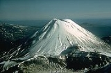
Mount Ngauruhoe is an active stratovolcano
or composite cone in New Zealand
, made from layers of lava and tephra
. It is the youngest vent in the Tongariro
volcanic complex on the Central Plateau of the North Island
, and first erupted about 2,500 years ago. Although seen by most as a volcano in its own right, it is technically a secondary cone of Mount Tongariro
.
The volcano lies between the active volcanoes of Mount Tongariro to the north and Mount Ruapehu
to the south, to the west of the Rangipo Desert
25 kilometres to the south of the southern shore of Lake Taupo
.
, an ancestor of the local Māori iwi
, Ngāti Tūwharetoa
. Local traditions say that Ngātoro-i-rangi called volcanic fire from his homeland Hawaiki
which eventually emerged at Ngauruhoe.
The name either commemorates his slave, who had died from the cold before the fire arrived, or refers to the insertions (ngā uru) of his hoe (paddle-like staff) into the ground.
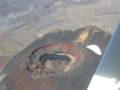
s exist inside the inner crater
and on the rim of the eastern, outer crater. Climbers who suffer from asthma
may be affected by the strong sulphurous gases emitted from the crater.
 Ngauruhoe is no longer showing signs of any significant unrest and the Volcanic Alert Level has been reduced to zero (typical background activity).
A significant increase in earthquake activity in May 2006 prompted the alert level to be raised to one (signs of volcano unrest). Over the next two years GeoNet recorded an average of 5 to 30 earthquakes a day close to Ngauruhoe, though the maximum daily number was as high as 80.
Since mid-2008 the number of volcanic earthquakes close to Ngauruhoe has declined to the background level. Regular measurements of volcanic gas levels and the temperature of a summit gas vent have failed to record any significant changes over the last two and a half years. “Since mid-2008 the number of earthquakes has returned to a typical level of a few per week” GNS Science accordingly reduced the alert level for Ngauruhoe to Level 0 on 2 December 2008. “The reduction in earthquake activity means that an eruption in the near future is unlikely without further earthquakes or other changes and the appropriate alert level is therefore zero”, said GNS Science Volcano Section Manager Gill Jolly.
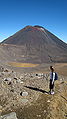 The mountain is usually climbed from the eastern side, from the Mangatepopo track. From the Mangateopopo hut to the base of the mountain takes a steady 1 1/2 hour walk; the first 45 minutes are suitable for children or older people. The track then climbs very steeply to the base of the climb. In summer the climb is difficult due to the loose tephra
that gives way underfoot. In the summer of 2010 a climber was seriously injured by falling rock. In winter, snow consolidates the tephra. As the slope is about 45 degrees, kicking steps is essential, and this requires fitness. After rain, the snow may be covered by ice which is treacherous. Ice axes, crampons and ropes are recommended in mid winter. Climbers should practice self arrest with ice axes on the lower slopes if icy conditions prevail.
Experienced and fit climbers can attempt the climb from the northern side by cutting across the lava flows in the Mangatepopo valley from the Mangatepopo hut.This route is far longer with no flat areas for rest and is not recommended for casual climbers.Climbers on reaching the summit can circum-navigate the crater and descend the normal eastern route.
in Peter Jackson
's The Lord of the Rings movie trilogy
, achieving worldwide exposure.
Stratovolcano
A stratovolcano, also known as a composite volcano, is a tall, conical volcano built up by many layers of hardened lava, tephra, pumice, and volcanic ash. Unlike shield volcanoes, stratovolcanoes are characterized by a steep profile and periodic, explosive eruptions...
or composite cone in New Zealand
New Zealand
New Zealand is an island country in the south-western Pacific Ocean comprising two main landmasses and numerous smaller islands. The country is situated some east of Australia across the Tasman Sea, and roughly south of the Pacific island nations of New Caledonia, Fiji, and Tonga...
, made from layers of lava and tephra
Tephra
200px|thumb|right|Tephra horizons in south-central [[Iceland]]. The thick and light coloured layer at center of the photo is [[rhyolitic]] tephra from [[Hekla]]....
. It is the youngest vent in the Tongariro
Mount Tongariro
Mount Tongariro is a volcanic complex in the North Island of New Zealand. It is located 20 kilometres to the southwest of Lake Taupo, and is the northernmost of the three active volcanoes that dominate the landscape of the central North Island....
volcanic complex on the Central Plateau of the North Island
North Island
The North Island is one of the two main islands of New Zealand, separated from the much less populous South Island by Cook Strait. The island is in area, making it the world's 14th-largest island...
, and first erupted about 2,500 years ago. Although seen by most as a volcano in its own right, it is technically a secondary cone of Mount Tongariro
Mount Tongariro
Mount Tongariro is a volcanic complex in the North Island of New Zealand. It is located 20 kilometres to the southwest of Lake Taupo, and is the northernmost of the three active volcanoes that dominate the landscape of the central North Island....
.
The volcano lies between the active volcanoes of Mount Tongariro to the north and Mount Ruapehu
Mount Ruapehu
Mount Ruapehu, or just Ruapehu, is an active stratovolcano at the southern end of the Taupo Volcanic Zone in New Zealand. It is 23 kilometres northeast of Ohakune and 40 kilometres southwest of the southern shore of Lake Taupo, within Tongariro National Park...
to the south, to the west of the Rangipo Desert
Rangipo Desert
Rangipo Desert is a barren desert-like environment in New Zealand, located in the Ruapehu District on the North Island Volcanic Plateau; to the east of the three active peaks of Mount Tongariro, Mount Ngauruhoe, and Mount Ruapehu, and to the west of the Kaimanawa Range.The Rangipo Desert receives...
25 kilometres to the south of the southern shore of Lake Taupo
Lake Taupo
Lake Taupo is a lake situated in the North Island of New Zealand. With a surface area of , it is the largest lake by surface area in New Zealand, and the second largest freshwater lake by surface area in geopolitical Oceania after Lake Murray ....
.
Māori traditions
The volcano was named by Ngātoro-i-rangiNgatoro-i-rangi
In Māori tradition, Ngātoro-i-rangi is the name of a tohunga prominent during the settling of Aotearoa by the Māori people, who came from the mythical homeland Hawaiki.-Rangiātea:...
, an ancestor of the local Māori iwi
Iwi
In New Zealand society, iwi form the largest everyday social units in Māori culture. The word iwi means "'peoples' or 'nations'. In "the work of European writers which treat iwi and hapū as parts of a hierarchical structure", it has been used to mean "tribe" , or confederation of tribes,...
, Ngāti Tūwharetoa
Ngati Tuwharetoa
Ngāti Tūwharetoa is an iwi descended from Ngātoro-i-rangi, the priest who navigated the Arawa canoe to New Zealand. The Tūwharetoa region extends from Te Awa o te Atua at Matata across the central plateau of the North Island to the lands around Mount Tongariro and Lake Taupo.The iwi is identified...
. Local traditions say that Ngātoro-i-rangi called volcanic fire from his homeland Hawaiki
Hawaiki
In Māori mythology, Hawaiki is the homeland of the Māori, the original home of the Māori, before they travelled across the sea to New Zealand...
which eventually emerged at Ngauruhoe.
The name either commemorates his slave, who had died from the cold before the fire arrived, or refers to the insertions (ngā uru) of his hoe (paddle-like staff) into the ground.
Recent activity
Ngauruhoe erupted 45 times in the 20th century, most recently in 1977. FumaroleFumarole
A fumarole is an opening in a planet's crust, often in the neighborhood of volcanoes, which emits steam and gases such as carbon dioxide, sulfur dioxide, hydrochloric acid, and hydrogen sulfide. The steam is created when superheated water turns to steam as its pressure drops when it emerges from...
s exist inside the inner crater
Volcanic crater
A volcanic crater is a circular depression in the ground caused by volcanic activity. It is typically a basin, circular in form within which occurs a vent from which magma erupts as gases, lava, and ejecta. A crater can be of large dimensions, and sometimes of great depth...
and on the rim of the eastern, outer crater. Climbers who suffer from asthma
Asthma
Asthma is the common chronic inflammatory disease of the airways characterized by variable and recurring symptoms, reversible airflow obstruction, and bronchospasm. Symptoms include wheezing, coughing, chest tightness, and shortness of breath...
may be affected by the strong sulphurous gases emitted from the crater.
A significant increase in earthquake activity in May 2006 prompted the alert level to be raised to one (signs of volcano unrest). Over the next two years GeoNet recorded an average of 5 to 30 earthquakes a day close to Ngauruhoe, though the maximum daily number was as high as 80.
Since mid-2008 the number of volcanic earthquakes close to Ngauruhoe has declined to the background level. Regular measurements of volcanic gas levels and the temperature of a summit gas vent have failed to record any significant changes over the last two and a half years. “Since mid-2008 the number of earthquakes has returned to a typical level of a few per week” GNS Science accordingly reduced the alert level for Ngauruhoe to Level 0 on 2 December 2008. “The reduction in earthquake activity means that an eruption in the near future is unlikely without further earthquakes or other changes and the appropriate alert level is therefore zero”, said GNS Science Volcano Section Manager Gill Jolly.
Climbing
Tephra
200px|thumb|right|Tephra horizons in south-central [[Iceland]]. The thick and light coloured layer at center of the photo is [[rhyolitic]] tephra from [[Hekla]]....
that gives way underfoot. In the summer of 2010 a climber was seriously injured by falling rock. In winter, snow consolidates the tephra. As the slope is about 45 degrees, kicking steps is essential, and this requires fitness. After rain, the snow may be covered by ice which is treacherous. Ice axes, crampons and ropes are recommended in mid winter. Climbers should practice self arrest with ice axes on the lower slopes if icy conditions prevail.
Experienced and fit climbers can attempt the climb from the northern side by cutting across the lava flows in the Mangatepopo valley from the Mangatepopo hut.This route is far longer with no flat areas for rest and is not recommended for casual climbers.Climbers on reaching the summit can circum-navigate the crater and descend the normal eastern route.
Film appearance
In the early 2000s Mount Ngauruhoe was used as a stand-in for the fictional Mount DoomMount Doom
Mount Doom is a volcano in J. R. R. Tolkien's Middle-earth legendarium. It is located in the heart of the black land of Mordor and close to Barad-dûr, it is approximately high. Alternative names, in Tolkien's invented language of Sindarin, include Orodruin and Amon Amarth...
in Peter Jackson
Peter Jackson
Sir Peter Robert Jackson, KNZM is a New Zealand film director, producer, actor, and screenwriter, known for his The Lord of the Rings film trilogy , adapted from the novel by J. R. R...
's The Lord of the Rings movie trilogy
The Lord of the Rings film trilogy
The Lord of the Rings is an epic film trilogy consisting of three fantasy adventure films based on the three-volume book of the same name by English author J. R. R. Tolkien. The films are The Fellowship of the Ring , The Two Towers and The Return of the King .The films were directed by Peter...
, achieving worldwide exposure.
See also
- List of volcanoes in New Zealand
- List of mountains of New Zealand by height
- Volcanism in New ZealandVolcanism in New ZealandThe volcanism of New Zealand has been responsible for many of the country's geographical features, especially in the North Island and the country's outlying islands...
- RuapehuMount RuapehuMount Ruapehu, or just Ruapehu, is an active stratovolcano at the southern end of the Taupo Volcanic Zone in New Zealand. It is 23 kilometres northeast of Ohakune and 40 kilometres southwest of the southern shore of Lake Taupo, within Tongariro National Park...
- Tongariro