
Pacific Ranges
Encyclopedia
The Pacific Ranges are the southernmost subdivision of the Coast Mountains
portion of the Pacific Cordillera
. Located entirely within British Columbia, Canada
, they run northwest from the lower stretches of the Fraser River
to Bella Coola
, north of which are the Kitimat Ranges
.
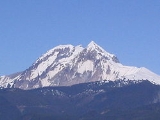
The Pacific Ranges include four of the five major coastal icecaps in the southern Coast Mountains
. These are the largest temperate-latitude icecaps in the world and fuel a number of very major rivers (by volume, not length). One of these contains Mount Waddington
, the highest summit entirely within British Columbia
. Also within this region is Hunlen Falls
, among the highest in Canada
, located in Tweedsmuir South Provincial Park
.
Other than logging and a large ski resort at Whistler
most of the land in the range is completely undeveloped. Historically, in the southern part of the range, mining was important at various times in the Lillooet, Bridge River and Squamish areas, and large pulp and paper mills at Powell River, Port Mellon and Woodfibre. The largest hydroelectric development in the Pacific Ranges is the Bridge River Power Project
, though smaller hydro plants are on the Stave River-Alouette Lake system in Mission and Maple Ridge, the Daisy Lake-Squamish River division of the Cheakamus Powerhouse, and another power dam and power plant at Clowhom. Although the range was extensively surveyed for possible rail routes, only that of the Pacific Great Eastern (now part of CN) was eventually built; the Homathko River-Bute Inlet route, however, was one of the two main choices in the deliberations of the CPR's routing.
 The Pacific Ranges are part of the southern portion of the Coast Plutonic Complex and has been characterized by rapid rates of uplift over the past 4 million years, which has led to relatively high rates of erosion
.
The Garibaldi Volcanic Belt
is within the Pacific Ranges, which is a volcanic belt
formed by the subduction
of the Juan de Fuca Plate
(a remnant of the much larger Farallon Plate
) under the North American Plate
along the Cascadia subduction zone
. The belt is the northern extension of the Cascade Volcanic Arc
in the United States
(which includes the volcanoes Mount St. Helens
and Mount Baker
) and contains the most explosive young volcanoes in Canada. The eruption styles in the belt range from effusive
to explosive
, with compositions from basalt
to rhyolite
. Morphologically, centers include caldera
s, cinder cone
s, stratovolcano
es and small isolated lava
masses. Due to repeated continental and alpine glaciations, many of the volcanic deposits in the belt reflect complex interactions between magma
composition, topography, and changing ice configurations. The most recent major catastrophic eruption in the Garibaldi Volcanic Belt was from Mount Meager
2,350 BP
, which is Canada's most recent major catastrophic eruption.
The Garibaldi Volcanic Belt contains 2 extra volcanic fields, the Franklin Glacier Volcano
and the Silverthrone Caldera
, which lie 140 and 190 km northwest of the main volcanic belt.
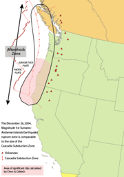
The Cascadia subduction zone
is a 680 mi (1,094 km) long fault
, running 50 mi (80 km) off the west-coast of the Pacific Northwest
from northern California
to Vancouver Island
. The plates move at a relative rate of over 0.4 inches (10 mm) per year at a somewhat oblique angle to the subduction zone.
Unlike most subduction zones worldwide, there is no oceanic trench
present along the continental margin
in Cascadia
. Instead, terrane
s and the accretionary wedge
have been uplifted to form a series of coast ranges and exotic mountains. A high rate of sedimentation from the outflow of the three major rivers (Fraser River
, Columbia River
, and Klamath River
) which cross the Cascade Range contributes to further obscuring the presence of a trench. However, in common with most other subduction zones, the outer margin is slowly being compressed, similar to a giant spring
. When the stored energy is suddenly released by slippage across the fault at irregular intervals, the Cascadia subduction zone can create very large earthquake
s such as the magnitude
9 Cascadia earthquake of 1700.
Many smaller ranges and subranges are not listed at present.
these are also considered to be "ranges
" but are listed separately here because of their unique character).
List is incomplete
Some Protected areas, recreation areas and other non-park preservation areas are not listed.
Many relatively unknown rivers of considerable size along the coastal flank of the range are not listed, partly because they are largely unknown and also very difficult to access.
Coast Mountains
The Coast Mountains are a major mountain range, in the Pacific Coast Ranges, of western North America, extending from southwestern Yukon through the Alaska Panhandle and virtually all of the Coast of British Columbia. They are so-named because of their proximity to the sea coast, and are often...
portion of the Pacific Cordillera
Pacific Cordillera
The Pacific Cordillera is a top-level physiographic region of Canada. This cordillera is part of the Western Cordillera of North America. The mountain ranges in this region were covered during the Pleistocene by the Cordilleran Ice Sheet...
. Located entirely within British Columbia, Canada
British Columbia
British Columbia is the westernmost of Canada's provinces and is known for its natural beauty, as reflected in its Latin motto, Splendor sine occasu . Its name was chosen by Queen Victoria in 1858...
, they run northwest from the lower stretches of the Fraser River
Fraser River
The Fraser River is the longest river within British Columbia, Canada, rising at Fraser Pass near Mount Robson in the Rocky Mountains and flowing for , into the Strait of Georgia at the city of Vancouver. It is the tenth longest river in Canada...
to Bella Coola
Bella Coola, British Columbia
Bella Coola is a community of approximately 600 at the western extremity of the Bella Coola Valley. Bella Coola usually refers to the entire valley, encompassing the settlements of Bella Coola proper , Lower Bella Coola, Hagensborg, Saloompt, Nusatsum, Firvale and Stuie...
, north of which are the Kitimat Ranges
Kitimat Ranges
The Kitimat Ranges are one of the three main subdivisions of the Coast Mountains in British Columbia, Canada, the other being the Pacific Ranges to the south and the Boundary Ranges to the north...
.
The Pacific Ranges include four of the five major coastal icecaps in the southern Coast Mountains
Coast Mountains
The Coast Mountains are a major mountain range, in the Pacific Coast Ranges, of western North America, extending from southwestern Yukon through the Alaska Panhandle and virtually all of the Coast of British Columbia. They are so-named because of their proximity to the sea coast, and are often...
. These are the largest temperate-latitude icecaps in the world and fuel a number of very major rivers (by volume, not length). One of these contains Mount Waddington
Mount Waddington
Mount Waddington, once known as Mystery Mountain, is the highest peak in the Coast Mountains of British Columbia, Canada. Although Mount Fairweather and Mount Quincy Adams, which straddle the US border between Alaska and British Columbia are taller, Mount Waddington is the highest peak that lies...
, the highest summit entirely within British Columbia
British Columbia
British Columbia is the westernmost of Canada's provinces and is known for its natural beauty, as reflected in its Latin motto, Splendor sine occasu . Its name was chosen by Queen Victoria in 1858...
. Also within this region is Hunlen Falls
Hunlen Falls
Hunlen Falls is a waterfall in the Pacific Ranges of the Coast Mountains of British Columbia, Canada. It is located in Tweedsmuir South Provincial Park, west of the communities of Tatla Lake, Kleena Kleene and Nimpo Lake, and east of Bella Coola. It is the highest waterfall in Canada when measured...
, among the highest in Canada
Canada
Canada is a North American country consisting of ten provinces and three territories. Located in the northern part of the continent, it extends from the Atlantic Ocean in the east to the Pacific Ocean in the west, and northward into the Arctic Ocean...
, located in Tweedsmuir South Provincial Park
Tweedsmuir South Provincial Park
Tweedsmuir South Provincial Park is a provincial park in British Columbia, Canada. Formerly part of Tweedsmuir Provincial Park it was formed from the southern portion of that park, the northern portion being redesignated Tweedsmuir North Provincial Park and Protected Area in order to allow...
.
Other than logging and a large ski resort at Whistler
Whistler, British Columbia
Whistler is a Canadian resort town in the southern Pacific Ranges of the Coast Mountains in the province of British Columbia, Canada, approximately north of Vancouver...
most of the land in the range is completely undeveloped. Historically, in the southern part of the range, mining was important at various times in the Lillooet, Bridge River and Squamish areas, and large pulp and paper mills at Powell River, Port Mellon and Woodfibre. The largest hydroelectric development in the Pacific Ranges is the Bridge River Power Project
Bridge River Power Project
The Bridge River Power Project is a hydroelectric power development in the Canadian province of British Columbia, located in the Lillooet Country between Whistler and Lillooet...
, though smaller hydro plants are on the Stave River-Alouette Lake system in Mission and Maple Ridge, the Daisy Lake-Squamish River division of the Cheakamus Powerhouse, and another power dam and power plant at Clowhom. Although the range was extensively surveyed for possible rail routes, only that of the Pacific Great Eastern (now part of CN) was eventually built; the Homathko River-Bute Inlet route, however, was one of the two main choices in the deliberations of the CPR's routing.
Geology
Erosion
Erosion is when materials are removed from the surface and changed into something else. It only works by hydraulic actions and transport of solids in the natural environment, and leads to the deposition of these materials elsewhere...
.
The Garibaldi Volcanic Belt
Garibaldi Volcanic Belt
The Garibaldi Volcanic Belt, also called the Canadian Cascade Arc, is a northwest-southeast trending volcanic chain in the Pacific Ranges of the Coast Mountains that extends from Watts Point in the south to the Ha-Iltzuk Icefield in the north. This chain of volcanoes is located in southwestern...
is within the Pacific Ranges, which is a volcanic belt
Volcanic belt
A volcanic belt is a large volcanically active region. Other terms are used for smaller areas of activity, such as volcanic fields. Volcanic belts are found above zones of unusually high temperature where magma is created by partial melting of solid material in the Earth's crust and upper mantle....
formed by the subduction
Subduction
In geology, subduction is the process that takes place at convergent boundaries by which one tectonic plate moves under another tectonic plate, sinking into the Earth's mantle, as the plates converge. These 3D regions of mantle downwellings are known as "Subduction Zones"...
of the Juan de Fuca Plate
Juan de Fuca Plate
The Juan de Fuca Plate, named after the explorer of the same name, is a tectonic plate, generated from the Juan de Fuca Ridge, and subducting under the northerly portion of the western side of the North American Plate at the Cascadia subduction zone...
(a remnant of the much larger Farallon Plate
Farallon Plate
The Farallon Plate was an ancient oceanic plate, which began subducting under the west coast of the North American Plate— then located in modern Utah— as Pangaea broke apart during the Jurassic Period...
) under the North American Plate
North American Plate
The North American Plate is a tectonic plate covering most of North America, Greenland, Cuba, Bahamas, and parts of Siberia, Japan and Iceland. It extends eastward to the Mid-Atlantic Ridge and westward to the Chersky Range in eastern Siberia. The plate includes both continental and oceanic crust...
along the Cascadia subduction zone
Cascadia subduction zone
The Cascadia subduction zone is a subduction zone, a type of convergent plate boundary that stretches from northern Vancouver Island to northern California. It is a very long sloping fault that separates the Juan de Fuca and North America plates.New ocean floor is being created offshore of...
. The belt is the northern extension of the Cascade Volcanic Arc
Cascade Volcanoes
The Cascade Volcanoes are a number of volcanoes in a volcanic arc in western North America, extending from southwestern British Columbia through Washington and Oregon to Northern California, a distance of well over 700 mi ...
in the United States
United States
The United States of America is a federal constitutional republic comprising fifty states and a federal district...
(which includes the volcanoes Mount St. Helens
Mount St. Helens
Mount St. Helens is an active stratovolcano located in Skamania County, Washington, in the Pacific Northwest region of the United States. It is south of Seattle, Washington and northeast of Portland, Oregon. Mount St. Helens takes its English name from the British diplomat Lord St Helens, a...
and Mount Baker
Mount Baker
Mount Baker , also known as Koma Kulshan or simply Kulshan, is an active glaciated andesitic stratovolcano in the Cascade Volcanic Arc and the North Cascades of Washington State in the United States. It is the second-most active volcano in the range after Mount Saint Helens...
) and contains the most explosive young volcanoes in Canada. The eruption styles in the belt range from effusive
Effusive eruption
An effusive eruption is a volcanic eruption characterized by the outpouring of lava onto the ground...
to explosive
Explosive eruption
An explosive eruption is a volcanic term to describe a violent, explosive type of eruption. Mount St. Helens in 1980 was an example. Such an eruption is driven by gas accumulating under great pressure. Driven by hot rising magma, it interacts with ground water until the pressure increases to the...
, with compositions from basalt
Basalt
Basalt is a common extrusive volcanic rock. It is usually grey to black and fine-grained due to rapid cooling of lava at the surface of a planet. It may be porphyritic containing larger crystals in a fine matrix, or vesicular, or frothy scoria. Unweathered basalt is black or grey...
to rhyolite
Rhyolite
This page is about a volcanic rock. For the ghost town see Rhyolite, Nevada, and for the satellite system, see Rhyolite/Aquacade.Rhyolite is an igneous, volcanic rock, of felsic composition . It may have any texture from glassy to aphanitic to porphyritic...
. Morphologically, centers include caldera
Caldera
A caldera is a cauldron-like volcanic feature usually formed by the collapse of land following a volcanic eruption, such as the one at Yellowstone National Park in the US. They are sometimes confused with volcanic craters...
s, cinder cone
Cinder cone
According to the , Cinder Cone is the proper name of 1 cinder cone in Canada and 7 cinder cones in the United States:In Canada: Cinder Cone In the United States:...
s, stratovolcano
Stratovolcano
A stratovolcano, also known as a composite volcano, is a tall, conical volcano built up by many layers of hardened lava, tephra, pumice, and volcanic ash. Unlike shield volcanoes, stratovolcanoes are characterized by a steep profile and periodic, explosive eruptions...
es and small isolated lava
Lava
Lava refers both to molten rock expelled by a volcano during an eruption and the resulting rock after solidification and cooling. This molten rock is formed in the interior of some planets, including Earth, and some of their satellites. When first erupted from a volcanic vent, lava is a liquid at...
masses. Due to repeated continental and alpine glaciations, many of the volcanic deposits in the belt reflect complex interactions between magma
Magma
Magma is a mixture of molten rock, volatiles and solids that is found beneath the surface of the Earth, and is expected to exist on other terrestrial planets. Besides molten rock, magma may also contain suspended crystals and dissolved gas and sometimes also gas bubbles. Magma often collects in...
composition, topography, and changing ice configurations. The most recent major catastrophic eruption in the Garibaldi Volcanic Belt was from Mount Meager
Mount Meager
Mount Meager, originally known as Meager Mountain, is a complex volcano in the Sea-to-Sky Corridor of southwestern British Columbia, Canada. It is located north of Vancouver at the northern end of the Pemberton Valley. Part of the Cascade Volcanic Arc of western North America, its summit is above...
2,350 BP
Before Present
Before Present years is a time scale used in archaeology, geology, and other scientific disciplines to specify when events in the past occurred. Because the "present" time changes, standard practice is to use AD 1950 as the origin of the age scale, reflecting the fact that radiocarbon...
, which is Canada's most recent major catastrophic eruption.
The Garibaldi Volcanic Belt contains 2 extra volcanic fields, the Franklin Glacier Volcano
Franklin Glacier Volcano
Franklin Glacier Volcano is a deeply eroded and huge long and wide caldera complex in southwestern British Columbia, Canada, located east-southeast of the Silverthrone Caldera in the Hoodoo Creek and Franklin Glacier area on the northwest flank of the Waddington Massif of the Pacific Ranges...
and the Silverthrone Caldera
Silverthrone Caldera
The Silverthrone Caldera is a potentially active caldera complex in southwestern British Columbia, Canada, located over northwest of the city of Vancouver and about west of Mount Waddington in the Pacific Ranges of the Coast Mountains. The caldera is one of the largest of the few calderas in...
, which lie 140 and 190 km northwest of the main volcanic belt.
The Cascadia subduction zone
Cascadia subduction zone
The Cascadia subduction zone is a subduction zone, a type of convergent plate boundary that stretches from northern Vancouver Island to northern California. It is a very long sloping fault that separates the Juan de Fuca and North America plates.New ocean floor is being created offshore of...
is a 680 mi (1,094 km) long fault
Geologic fault
In geology, a fault is a planar fracture or discontinuity in a volume of rock, across which there has been significant displacement along the fractures as a result of earth movement. Large faults within the Earth's crust result from the action of tectonic forces...
, running 50 mi (80 km) off the west-coast of the Pacific Northwest
Pacific Northwest
The Pacific Northwest is a region in northwestern North America, bounded by the Pacific Ocean to the west and, loosely, by the Rocky Mountains on the east. Definitions of the region vary and there is no commonly agreed upon boundary, even among Pacific Northwesterners. A common concept of the...
from northern California
Northern California
Northern California is the northern portion of the U.S. state of California. The San Francisco Bay Area , and Sacramento as well as its metropolitan area are the main population centers...
to Vancouver Island
Vancouver Island
Vancouver Island is a large island in British Columbia, Canada. It is one of several North American locations named after George Vancouver, the British Royal Navy officer who explored the Pacific Northwest coast of North America between 1791 and 1794...
. The plates move at a relative rate of over 0.4 inches (10 mm) per year at a somewhat oblique angle to the subduction zone.
Unlike most subduction zones worldwide, there is no oceanic trench
Oceanic trench
The oceanic trenches are hemispheric-scale long but narrow topographic depressions of the sea floor. They are also the deepest parts of the ocean floor....
present along the continental margin
Continental margin
The continental margin is the zone of the ocean floor that separates the thin oceanic crust from thick continental crust. Continental margins constitute about 28% of the oceanic area....
in Cascadia
Cascadia
Cascadia, a term that derives from the Cascade Range, may refer to:* the Pacific Northwest* Cascadia, a former plant genus now included in Saxifraga* 1700 Cascadia earthquake...
. Instead, terrane
Terrane
A terrane in geology is short-hand term for a tectonostratigraphic terrane, which is a fragment of crustal material formed on, or broken off from, one tectonic plate and accreted or "sutured" to crust lying on another plate...
s and the accretionary wedge
Accretionary wedge
An accretionary wedge or accretionary prism is formed from sediments that are accreted onto the non-subducting tectonic plate at a convergent plate boundary...
have been uplifted to form a series of coast ranges and exotic mountains. A high rate of sedimentation from the outflow of the three major rivers (Fraser River
Fraser River
The Fraser River is the longest river within British Columbia, Canada, rising at Fraser Pass near Mount Robson in the Rocky Mountains and flowing for , into the Strait of Georgia at the city of Vancouver. It is the tenth longest river in Canada...
, Columbia River
Columbia River
The Columbia River is the largest river in the Pacific Northwest region of North America. The river rises in the Rocky Mountains of British Columbia, Canada, flows northwest and then south into the U.S. state of Washington, then turns west to form most of the border between Washington and the state...
, and Klamath River
Klamath River
The Klamath River is an American river that flows southwest through Oregon and northern California, cutting through the Cascade Range to empty into the Pacific Ocean. The river drains an extensive watershed of almost that stretches from the high desert country of the Great Basin to the temperate...
) which cross the Cascade Range contributes to further obscuring the presence of a trench. However, in common with most other subduction zones, the outer margin is slowly being compressed, similar to a giant spring
Spring (device)
A spring is an elastic object used to store mechanical energy. Springs are usually made out of spring steel. Small springs can be wound from pre-hardened stock, while larger ones are made from annealed steel and hardened after fabrication...
. When the stored energy is suddenly released by slippage across the fault at irregular intervals, the Cascadia subduction zone can create very large earthquake
Earthquake
An earthquake is the result of a sudden release of energy in the Earth's crust that creates seismic waves. The seismicity, seismism or seismic activity of an area refers to the frequency, type and size of earthquakes experienced over a period of time...
s such as the magnitude
Richter magnitude scale
The expression Richter magnitude scale refers to a number of ways to assign a single number to quantify the energy contained in an earthquake....
9 Cascadia earthquake of 1700.
Major Named Subranges
- Rainbow RangeRainbow Range (Coast Mountains)The Rainbow Range, formerly known as the Rainbow Mountains, is a mountain range in British Columbia, Canada, located northwest of Anahim Lake...
- Niut RangeNiut RangeThe Niut Range is 3600 km² in area. It is a subrange of the Pacific Ranges of the Coast Mountains of British Columbia, although in some classifications it is considered part of the Chilcotin Ranges . The Niut and is located in the angle of the Homathko River and its main west fork, Mosley...
- Pantheon RangePantheon RangeThe Pantheon Range is a subrange of the Pacific Ranges of the Coast Mountains in British Columbia. It is located between the edge of the Chilcotin Plateau at Tatla Lake on its northeast and the Klinaklini River on its west, with a southeastern boundary along Mosley Creek, a major tributary of the...
- Waddington RangeWaddington RangeThe Waddington Range is a subrange of the Pacific Ranges of the Coast Mountains in southwestern British Columbia, Canada. It is only about 4000 km² in area, relatively small in area within the expanse of the range, but it is the highest area of the Pacific Ranges and of the Coast Mountains, being...
- Whitemantle RangeWhitemantle RangeThe Whitemantle Range is a subrange of the Pacific Ranges of the Coast Mountains in British Columbia. Located between the heads of Bute Inlet on the east and Knight Inlet on the west, it is extremely rugged and glaciated...
- Chilcotin RangesChilcotin RangesThe Chilcotin Ranges are a subdivision of the Pacific Ranges of the Coast Mountains . They lie on the inland lea of the Pacific Ranges, abutting the Interior Plateau of British Columbia...
- Shulaps RangeShulaps RangeThe Shulaps Range is a subrange of the Chilcotin Ranges subset of the Pacific Ranges of the Coast Mountains in southwest-central British Columbia. The range is 55 km NW–SE and 15 km SW–NE and 2,970 km² in area....
- Dickson RangeDickson RangeThe Dickson Range is a subrange of the Chilcotin Ranges subset of the Pacific Ranges of the Coast Mountains in southwest-central British Columbia. It is located just west of the town of Gold Bridge between the valley of Slim Creek to the north and Downton Lake Reservoir to the south...
- Camelsfoot RangeCamelsfoot RangeThe Camelsfoot Range is a sub-range of the Chilcotin Ranges subdivision of the Pacific Ranges of the Coast Mountains in British Columbia.* The range is c...
- Shulaps Range
- Bendor RangeBendor RangeThe Bendor Range is a small but once-famous subrange of the Pacific Ranges of the Coast Mountains, about It is approximately 7,000 square kilometres in area and about 40 km long and about 18 km at its widest...
- Lillooet RangesLillooet RangesThe Lillooet Ranges are the southeasternmost subdivision of the Pacific Ranges of the Coast Mountains of British Columbia. They are located between the drainage of the Lillooet River and Harrison Lake on the west and the canyon of the Fraser River on the east, and by the lowland coastal valley of...
- Cayoosh RangeCayoosh RangeThe Cayoosh Range is the northernmost section of the Lillooet Ranges, which are a subrange of the Pacific Ranges of the Coast Mountains in British Columbia. The range is c...
- Cantilever RangeCantilever RangeThe Cantilever Range is a subrange of the Lillooet Ranges subgrouping of the Pacific Ranges of the Coast Mountains. About 1100 km² in area and about 50 km E-W and 35 km N-S, it is located southwest of Lytton between the valleys of the Stein River and Kwoiek Creek .The Cantilever...
- Cayoosh Range
- Douglas RangesDouglas RangesThe Douglas Ranges are a subrange of the Pacific Ranges of the Coast Mountains of the Canadian province of British Columbia, about 70 km east of downtown Vancouver, north of the Fraser River and between the valleys of Stave and Harrison Lakes. They are approximately 4900 km² in area...
- Garibaldi RangesGaribaldi RangesThe Garibaldi Ranges are the next-to-southwesternmost subdivision of the Pacific Ranges of the Coast Mountains; only the North Shore Mountains are farther south. They lie between the valley formed by the pass between the Cheakamus River and Green River on the west and the valley of the Lillooet...
- North Shore MountainsNorth Shore MountainsThe North Shore Mountains are a mountain range overlooking Vancouver in British Columbia, Canada. Their southernmost peaks are visible from most areas in Vancouver and form a distinctive backdrop for the city....
(Front Ranges) - Tantalus RangeTantalus RangeThe Tantalus Range is a small but spectacular subrange of the Pacific Ranges of the Coast Mountains in southern British Columbia, Canada. The range is well-known to travellers to and from the ski resort at Whistler as the stunning vista on the highway to the resort from Squamish.To Sḵwxwú7mesh,...
- Clendinning RangeClendinning RangeThe Clendenning Range is a subrange of the Pacific Ranges of the Coast Mountains of British Columbia. About 1500 km2 in area and lies to the northwest of the better-known Tantalus Range near Squamish...
-
- the Camelsfoot RangeCamelsfoot RangeThe Camelsfoot Range is a sub-range of the Chilcotin Ranges subdivision of the Pacific Ranges of the Coast Mountains in British Columbia.* The range is c...
running north along the west bank of the Fraser from Lillooet is sometimes considered to be part of the Chilcotin Ranges, but in other definitions is part of the Interior PlateauInterior PlateauThe Interior Plateau comprises a large region of central British Columbia, and lies between the Cariboo and Monashee Mountains on the east, and the Hazelton Mountains, Coast Mountains and Cascade Range on the west. The continuation of the plateau into the United States is known there as the...
- the Camelsfoot Range
Many smaller ranges and subranges are not listed at present.
Major Icefields
(Other than the Waddington RangeWaddington Range
The Waddington Range is a subrange of the Pacific Ranges of the Coast Mountains in southwestern British Columbia, Canada. It is only about 4000 km² in area, relatively small in area within the expanse of the range, but it is the highest area of the Pacific Ranges and of the Coast Mountains, being...
these are also considered to be "ranges
Ranges
Ranges - Lev. 11:35. Probably a cooking furnace for two or morepots, as the Hebrew word here is in the dual number; or perhapsa fire-place fitted to receive a pair of ovens. 2 Kings 11:8...
" but are listed separately here because of their unique character).
- Monarch IcefieldMonarch IcefieldThe Monarch Icefield is the northernmost of a series of large continental icecaps studding the heights of the Pacific Ranges of the Coast Mountains in southern British Columbia...
- Ha-Iltzuk IcefieldHa-Iltzuk IcefieldThe Ha-Iltzuk Icefield is an icefield in the central Pacific Ranges of the Coast Mountains in British Columbia, Canada. It is the largest icefield in the Coast Mountains south of the Alaska Panhandle, with an area of . It is located on the west side of the Klinaklini River and the Waddington Range...
(Silverthrone Glacier) - Waddington RangeWaddington RangeThe Waddington Range is a subrange of the Pacific Ranges of the Coast Mountains in southwestern British Columbia, Canada. It is only about 4000 km² in area, relatively small in area within the expanse of the range, but it is the highest area of the Pacific Ranges and of the Coast Mountains, being...
- Homathko IcefieldHomathko IcefieldThe Homathko Icefield is an icefield in British Columbia, Canada. Officially named the Homathko Snowfield from 1950 until the current name was adopted in 1976, it is one of the largest icefields in the southern half of the Coast Mountains, with an area of over...
- Lillooet IcecapLillooet IcecapThe Lillooet Icecap, also called the Lillooet Icefield or the Lillooet Crown, is a large icefield in the Pacific Ranges of the Coast Mountains in southwestern British Columbia, Canada. It is about northwest of the towns of Pemberton and Whistler, and about north of Vancouver, British Columbia...
(Lillooet Crown) - Pemberton Icecap
Major Peaks
- Mount WaddingtonMount WaddingtonMount Waddington, once known as Mystery Mountain, is the highest peak in the Coast Mountains of British Columbia, Canada. Although Mount Fairweather and Mount Quincy Adams, which straddle the US border between Alaska and British Columbia are taller, Mount Waddington is the highest peak that lies...
- Monarch MountainMonarch MountainMonarch Mountain is one of the principal summits of the Pacific Ranges subdivision of the Coast Mountains in southern British Columbia. It stands just east of a pass between the Klinaklini River and the south branch of the Atnarko River, which is a tributary of the Bella Coola River...
- Mount TiedemannMount TiedemannMount Tiedemann is one of the principal summits of the Pacific Ranges subdivision of the Coast Mountains of British Columbia. It is located northeast of Mount Waddington in the Waddington Range massif between the Homathko and Klinaklini Rivers....
- Mount MundayMount MundayMount Munday is one of the principal summits of the Pacific Ranges of the Coast Mountains in British Columbia, Canada. It is in elevation and stands in the Waddington Range six kilometres southeast of Mount Waddington , which is the highest summit in the Coast Mountains.The peak was named by...
- Mount Queen BessMount Queen BessMount Queen Bess is one of the principal summits of the Pacific Ranges of the Coast Mountains of southern British Columbia. It stands west of Chilko Lake and to the south of Tatlayoko Lake, and crowns a peak-studded ridge to the north of the Homathko Icefield....
- Mount Good HopeMount Good HopeOfficially Good Hope Mountain but commonly known as Mount Good Hope, this is one of the principal summits of the Pacific Ranges of the southern Coast Mountains in British Columbia, Canada...
- Mount RaleighMount RaleighMount Raleigh is one of the principal summits of the Pacific Ranges of the Coast Mountains of southern British Columbia. It is in elevation and is the highest summit south of the Bishop River's divide with the Lillooet River at Ring Pass, which is at the southeastern edge of the Lillooet Icefield...
- Monmouth MountainMonmouth MountainMonmouth Mountain, commonly known as Mount Monmouth is one of the principal summits of the Pacific Ranges of the Coast Mountains of southern British Columbia. At , it is the highest summit of the Chilcotin Ranges. It stands just north of the Lillooet Icecap between the heads of Chilko Lake and the...
- Mount TatlowMount TatlowMount Tatlow is one of the principal summits of the Chilcotin Ranges subdivision of the Pacific Ranges of the Coast Mountains of southern British Columbia...
- Taseko MountainTaseko MountainTaseko Mountain, also known as Mount Taseko 3063 m , prominence: 1277 m, is one of the principal summits of the Chilcotin Ranges, part of the Pacific Ranges subdivision of the Coast Mountains of southern British Columbia...
- Mount SilverthroneMount SilverthroneMount Silverthrone, officially named Silverthrone Mountain, is a mountain in the Regional District of Mount Waddington, British Columbia, located over northwest of the city of Vancouver and about west of Mount Waddington, British Columbia, Canada...
- Mount MeagerMount MeagerMount Meager, originally known as Meager Mountain, is a complex volcano in the Sea-to-Sky Corridor of southwestern British Columbia, Canada. It is located north of Vancouver at the northern end of the Pemberton Valley. Part of the Cascade Volcanic Arc of western North America, its summit is above...
- Mount CayleyMount CayleyMount Cayley is a potentially active stratovolcano in Squamish-Lillooet Regional District of southwestern British Columbia, Canada. Located north of Squamish and west of Whistler in the Pacific Ranges of the Coast Mountains, it rises above the Squamish River to the west and above the Cheakamus...
- Mount GaribaldiMount GaribaldiMount Garibaldi is a potentially active stratovolcano in the Sea to Sky Country of British Columbia, north of Vancouver, Canada. Located in the southernmost Coast Mountains, it is one of the most recognized peaks in the South Coast region, as well as British Columbia's best known volcano...
- Wedge MountainWedge MountainWedge Mountain, 2892 m prominence: 2249 m, often locally referred to as The Wedge or simply "Wedge", is the highest summit in the Garibaldi Ranges and therefore also Garibaldi Provincial Park, and is among the nearest of the many peaks visible from the Whistler Blackcomb Ski Area, lying north...
Provincial Parks
- Garibaldi Provincial ParkGaribaldi Provincial ParkGaribaldi Provincial Park, also called Garibaldi Park, is a wilderness park located in British Columbia, Canada, about 70 kilometres north of Vancouver. The park is located to the east of the Sea to Sky Highway between Squamish and Whistler and covers an area of over 1,950 square kilometres...
- Golden Ears Provincial ParkGolden Ears Provincial ParkGolden Ears Provincial Park is a Provincial Park in British Columbia, Canada at 555.9 km². It is named after the prominent twin peaks which are commonly referred to as Golden Ears...
- Cypress Provincial ParkCypress Provincial ParkCypress Provincial Park is a Provincial Park on the North Shore of Metro Vancouver, British Columbia. The park has two sections: a 21 km² southern section which is accessible by road, and a 9 km² northern section which is only accessible by hiking trails...
- Mount Seymour Provincial ParkMount Seymour Provincial ParkMount Seymour Provincial Park is a 35 km² park in Vancouver, British Columbia's North Shore Mountains. It is located approximately 15 km from Downtown Vancouver.-History and Geography:...
- Sasquatch Provincial ParkSasquatch Provincial ParkSasquatch Provincial Park is a provincial park in Kent, British Columbia, Canada.-History:The park was established 1968, in its present condition. It actually began in 1959 as a 20 hectare inland fjord called Green Point Park, which was expanded into a picnicking area in 1960. Eight years later the...
- Stein Valley Nlaka'pamux Heritage ParkStein Valley Nlaka'pamux Heritage ParkStein Valley Nlaka'pamux Heritage Park is a provincial park in British Columbia, Canada. Nearly the complete Stein River watershed from the mountains to the Fraser River is protected in this park, though there are some areas of the watershed that were left out....
- Birkenhead Lake Provincial ParkBirkenhead Lake Provincial ParkBirkenhead Lake Provincial Park is a provincial park in British Columbia, Canada, located in the Lillooet Country region to the northeast of Pemberton and immediately northwest of Birkenhead Peak and Gates Lake at the community of Birken....
- Big Creek Provincial ParkBig Creek Provincial ParkBig Creek Provincial Park is a provincial park in British Columbia, Canada.It is adjoined on the south by the Spruce Lake Protected Area and on the west by Ts'il?os Provincial Park. Neighbouring on the east is the Churn Creek Protected Area.- References :...
- Spruce Lake Protected AreaSpruce Lake Protected AreaThe Spruce Lake Protected Area, was a 71,347-hectare Protected Area in the British Columbia provincial parks system 200 km north of Vancouver. The area had been the subject of an ongoing preservationist controversy since the 1930s. Formerly known variously as the Southern Chilcotin Mountains...
- Ts'il?os Provincial ParkTs'il?os Provincial ParkTs'il?os Provincial Park is a provincial park in British Columbia, Canada. Ts'il?os is the official BC Parks designation for this provincial park, though sometimes it is written as "Ts'il-os", "Ts'yl-os", or "Tsylos"...
- Tweedsmuir North Provincial Park and Protected AreaTweedsmuir North Provincial Park and Protected AreaTweedsmuir North Provincial Park and Protected Area is a provincial park in British Columbia, Canada. Formerly part of Tweedsmuir Provincial Park, one of the earliest large parks established in the provincial parks system, it was redesignated a park and protected area as the latter classification...
- Tweedsmuir South Provincial ParkTweedsmuir South Provincial ParkTweedsmuir South Provincial Park is a provincial park in British Columbia, Canada. Formerly part of Tweedsmuir Provincial Park it was formed from the southern portion of that park, the northern portion being redesignated Tweedsmuir North Provincial Park and Protected Area in order to allow...
List is incomplete
Some Protected areas, recreation areas and other non-park preservation areas are not listed.
Major Rivers
- Fraser RiverFraser RiverThe Fraser River is the longest river within British Columbia, Canada, rising at Fraser Pass near Mount Robson in the Rocky Mountains and flowing for , into the Strait of Georgia at the city of Vancouver. It is the tenth longest river in Canada...
- Chilcotin RiverChilcotin RiverThe Chilcotin River is a long tributary of the Fraser River in southern British Columbia, Canada. It drains the Chilcotin Plateau, which lies between the Fraser River and the Coast Mountains...
- Bridge RiverBridge RiverThe Bridge River is, or was, a major tributary of British Columbia's Fraser River, entering that stream about six miles upstream from the town of Lillooet.-Name:Its name in the Lillooet language is Xwisten , sometimes spelled Nxwisten or Nxo-isten)...
- Lillooet RiverLillooet RiverThe Lillooet River is a major river of the southern Coast Mountains of British Columbia. It begins at Silt Lake, on the southern edge of the Lillooet Crown Icecap about 80 kilometres northwest of Pemberton and about 85 kilometres northwest of Whistler...
- Squamish RiverSquamish RiverThe Squamish River is a short but very large river in the Canadian province of British Columbia. Its drainage basin is in size. The total length of the Squamish River is approximately .-Course:...
- Homathko RiverHomathko RiverThe Homathko River is one of the major rivers of the southern Coast Mountains of British Columbia, and one of the few rivers that penetrates the range from the Chilcotin Plateau to the coastal inlets, entering the sea at the head of Bute Inlet adjacent to the mouth of the Southgate River, just to...
- Klinaklini RiverKlinaklini RiverThe Klinaklini River is one of the major rivers of the Pacific Ranges section of the Coast Mountains in British Columbia. It begins in the northern basins of the Pantheon Range to the north of Mount Waddington and briefly heads northeast onto the Chilcotin Plateau before bending around...
- Bella Coola RiverBella Coola RiverThe Bella Coola River is a major river on the Pacific slope of the Coast Mountains in southern British Columbia. The town of Bella Coola, which is the historic and ancient capital of the Nuxalk people, is at its mouth on North Bentinck Arm...
Many relatively unknown rivers of considerable size along the coastal flank of the range are not listed, partly because they are largely unknown and also very difficult to access.