

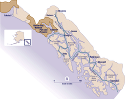
Alaska Panhandle
Encyclopedia
U.S. state
A U.S. state is any one of the 50 federated states of the United States of America that share sovereignty with the federal government. Because of this shared sovereignty, an American is a citizen both of the federal entity and of his or her state of domicile. Four states use the official title of...
of Alaska
Alaska
Alaska is the largest state in the United States by area. It is situated in the northwest extremity of the North American continent, with Canada to the east, the Arctic Ocean to the north, and the Pacific Ocean to the west and south, with Russia further west across the Bering Strait...
, which lies west of the northern half of the Canadian province
Provinces and territories of Canada
The provinces and territories of Canada combine to make up the world's second-largest country by area. There are ten provinces and three territories...
of British Columbia
British Columbia
British Columbia is the westernmost of Canada's provinces and is known for its natural beauty, as reflected in its Latin motto, Splendor sine occasu . Its name was chosen by Queen Victoria in 1858...
. The majority of Southeast Alaska's area is part of the Tongass National Forest
Tongass National Forest
The Tongass National Forest in southeastern Alaska is the largest national forest in the United States at 17 million acres . Most of its area is part of the temperate rain forest WWF ecoregion, itself part of the larger Pacific temperate rain forest WWF ecoregion, and is remote enough to be home...
, the United States' largest national forest
United States National Forest
National Forest is a classification of federal lands in the United States.National Forests are largely forest and woodland areas owned by the federal government and managed by the United States Forest Service, part of the United States Department of Agriculture. Land management of these areas...
. In many places, the international border
International Border
The India–Pakistan Border , known locally as the International Border , is the international boundary between India and Pakistan that demarcates the Indian states of Punjab, Rajasthan and Gujarat from the Pakistani provinces of Punjab and Sindh. Pakistan borders India in the east. The border...
runs along the crest of the Boundary Ranges
Boundary Ranges
The Boundary Ranges, also known in the singular and as the Alaska Boundary Range, are the largest and most northerly subrange of the Coast Mountains...
of the Coast Mountains
Coast Mountains
The Coast Mountains are a major mountain range, in the Pacific Coast Ranges, of western North America, extending from southwestern Yukon through the Alaska Panhandle and virtually all of the Coast of British Columbia. They are so-named because of their proximity to the sea coast, and are often...
(see Alaska boundary dispute
Alaska Boundary Dispute
The Alaska boundary dispute was a territorial dispute between the United States and Canada . It was resolved by arbitration in 1903. The dispute had been going on between the Russian and British Empires since 1821, and was inherited by the United States as a consequence of the Alaska Purchase in...
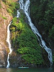
). The region is noted for its mild rainy climate and beautiful scenery.
Geography
Southeast Alaska is the northern terminus of the Inside PassageInside Passage
The Inside Passage is a coastal route for oceangoing vessels along a network of passages which weave through the islands on the Pacific coast of North America. The route extends from southeastern Alaska, in the United States, through western British Columbia, in Canada, to northwestern Washington...
, a protected waterway of convoluted passages between islands and fjords, beginning in Puget Sound
Puget Sound
Puget Sound is a sound in the U.S. state of Washington. It is a complex estuarine system of interconnected marine waterways and basins, with one major and one minor connection to the Strait of Juan de Fuca and the Pacific Ocean — Admiralty Inlet being the major connection and...
in Washington state
Washington State
Washington State may refer to:* Washington , often referred to as "Washington state" to differentiate it from Washington, D.C., the capital of the United States* Washington State University, a land-grant college in that state- See also :...
. This was an important travel corridor for native canoeists, as well as gold-rush steam ships, and in modern times is an important route for ferries and cruise ships.
Southeast Alaska has a land area of 35138 miles (56,549 km), comprising six entire borough
County-equivalent
A county-equivalent in the United States is a term used by the federal government to describe one of the two following governmental subdivisions:#A unit of local government in certain states which is comparable to a county as found in most states....
s and three census areas, in addition to the part of Yakutat Borough
Yakutat City and Borough, Alaska
Yakutat City and Borough is a unified city-borough in the U.S. state of Alaska. As of the 2010 census, the population was 4035. The name is Tlingit, Yaakwdáat, meaning "the place where canoes rest", but it originally derives from an Eyak name diyaʼqudaʼt and was influenced by the Tlingit word...
lying east of 141° West
141st meridian west
The meridian 141° west of Greenwich is a line of longitude that extends from the North Pole across the Arctic Ocean, North America, the Pacific Ocean, the Southern Ocean, and Antarctica to the South Pole....
longitude. Although it has only 6.14 percent of Alaska's land area, it is larger than the state of Maine
Maine
Maine is a state in the New England region of the northeastern United States, bordered by the Atlantic Ocean to the east and south, New Hampshire to the west, and the Canadian provinces of Quebec to the northwest and New Brunswick to the northeast. Maine is both the northernmost and easternmost...
, and almost as large as the state of Indiana
Indiana
Indiana is a US state, admitted to the United States as the 19th on December 11, 1816. It is located in the Midwestern United States and Great Lakes Region. With 6,483,802 residents, the state is ranked 15th in population and 16th in population density. Indiana is ranked 38th in land area and is...
. The 2000 census
United States Census, 2000
The Twenty-second United States Census, known as Census 2000 and conducted by the Census Bureau, determined the resident population of the United States on April 1, 2000, to be 281,421,906, an increase of 13.2% over the 248,709,873 persons enumerated during the 1990 Census...
population of Southeast was 72,954 inhabitants, about 42 percent of whom were concentrated in the city of Juneau
Juneau, Alaska
The City and Borough of Juneau is a unified municipality located on the Gastineau Channel in the panhandle of the U.S. state of Alaska. It has been the capital of Alaska since 1906, when the government of the then-District of Alaska was moved from Sitka as dictated by the U.S. Congress in 1900...
.
- Haines BoroughHaines Borough, Alaska-Demographics:As of the census of 2000, there were 2,392 people, 991 households, and 654 families residing in the borough. The population density was 0,88 people per square mile . There were 1,419 housing units at an average density of 0,52 per square mile...
- Hoonah-Angoon Census Area
- Juneau Borough
- Ketchikan Gateway BoroughKetchikan Gateway Borough, AlaskaAs of the census of 2000, there were 14,070 people, 5,399 households, and 3,633 families residing in the borough. The population density was 11 people per square mile . There were 6,218 housing units at an average density of 5 per square mile...
- Petersburg Census Area
- Prince of Wales-Hyder Census Area
- Sitka BoroughSitka City and Borough, AlaskaThe City and Borough of Sitka, originally called New Archangel under Russian Rule, is a unified city-borough located on Baranof Island and the southern half of Chichagof Island in the Alexander Archipelago of the Pacific Ocean , in the U.S...
- Skagway BoroughSkagway, AlaskaSkagway is a first-class borough in Alaska, on the Alaska Panhandle. It was formerly a city first incorporated in 1900 that was re-incorporated as a borough on June 25, 2007. As of the 2000 census, the population of the city was 862...
- Wrangell BoroughWrangell, AlaskaWrangell is a city and borough in the U.S. state of Alaska. At the 2000 census the population was 2,308.Its Tlingit name is Ḵaachx̱aana.áakʼw . The Tlingit people residing in the Wrangell area, who were there centuries before Europeans, call themselves the Shtaxʼhéen Ḵwáan after the nearby Stikine...
- Yakutat BoroughYakutat City and Borough, AlaskaYakutat City and Borough is a unified city-borough in the U.S. state of Alaska. As of the 2010 census, the population was 4035. The name is Tlingit, Yaakwdáat, meaning "the place where canoes rest", but it originally derives from an Eyak name diyaʼqudaʼt and was influenced by the Tlingit word...
(the part east of 141° W141st meridian westThe meridian 141° west of Greenwich is a line of longitude that extends from the North Pole across the Arctic Ocean, North America, the Pacific Ocean, the Southern Ocean, and Antarctica to the South Pole....
longitude; 12,506.53 km² / 4,828.80 sq mi, or about 63.12 percent of the borough)
It includes the Tongass National Forest
Tongass National Forest
The Tongass National Forest in southeastern Alaska is the largest national forest in the United States at 17 million acres . Most of its area is part of the temperate rain forest WWF ecoregion, itself part of the larger Pacific temperate rain forest WWF ecoregion, and is remote enough to be home...
, Glacier Bay National Park, Admiralty Island National Monument
Admiralty Island National Monument
Admiralty Island National Monument is located on Admiralty Island in Southeast Alaska. It was created December 1, 1978, and covers 955,747 acres of Tongass National Forest in the Panhandle of southeast Alaska...
, Misty Fjords National Monument
Misty Fjords National Monument
Misty Fiords National Monument is a National Monument and Wilderness Area administered by the US Department of Agriculture United States Forest Service 40 miles east of Ketchikan, Alaska, along the Inside Passage coast in extreme southeastern Alaska and covering 2,294,343 acres of Tongass...
, Alaska's Inside Passage, and myriad large and small islands. The largest islands are, from North to South, Chichagof Island
Chichagof Island
Chichagof Island, or Shee Kaax, is an island in the Alexander Archipelago of the Alaska Panhandle. At long and wide, it has a land area of , making it the fifth largest island in the United States and the 109th largest island in the world. It's coastline measures 742 miles. There was a 2000...
, Admiralty Island
Admiralty Island
Admiralty Island is an island in the Alexander Archipelago in Southeast Alaska, at . It is 145 km long and 56 km wide with an area of 4,264.1 km² , making it the seventh largest island in the United States and the 132nd largest island in the world. It is one of the...
, Baranof Island
Baranof Island
Baranof Island, also sometimes called Baranov Island, Shee or Sitka Island, is an island in the northern Alexander Archipelago in the Alaska Panhandle, in Alaska. The name Baranof was given in 1805 by Imperial Russian Navy captain U. F. Lisianski to honor Alexander Andreyevich Baranov...
, Kupreanof Island
Kupreanof Island
Kupreanof Island is an island in the Alexander Archipelago in southeastern Alaska. The island is long and wide with a total land area is , making it the 13th largest island in the United States and the 170th largest island in the world. The Lindenberg Peninsula, on the southeast side of the...
, Revillagigedo Island
Revillagigedo Island
Revillagigedo Island is an island in the Alexander Archipelago in Ketchikan Gateway Borough of the southeastern region of the U.S. state of Alaska. Running about 89 km north-south and 48 km east-west, it is 2,754.835 km² in area, making it the 12th largest island in the United...
and Prince of Wales Island. Major bodies of water of Southeast Alaska include Glacier Bay
Glacier Bay
Glacier Bay Basin in southeastern Alaska, United States, encompasses the Glacier Bay and surrounding mountains and glaciers, which was first proclaimed a U.S. National Monument on February 25, 1925 and which was later, on Dec...
, Lynn Canal
Lynn Canal
Lynn Canal is an inlet into the mainland of southeast Alaska.Lynn Canal runs about from the inlets of the Chilkat River south to Chatham Strait and Stephens Passage...
, Icy Strait
Icy Strait
The Icy Strait is a strait in the Alexander Archipelago in southeastern Alaska, at about . The strait separates Chichagof Island to the south and the Alaska mainland to the north. The strait is from its west side at the intersection of the Cross Sound and Glacier Bay to its east side at Chatham...
, Chatham Strait
Chatham Strait
Chatham Strait, or Shee ya xhaak in the Tlingit language, is a narrow passage of the Alexander Archipelago in the southeastern region of the U.S. state of Alaska. It separates Chichagof Island and Baranof Island to its west from Admiralty Island and Kuiu Island on its east.It is long and extends...
, Stephens Passage
Stephens Passage
Stephens Passage is a channel in the Alexander Archipelago in the southeastern region of the U.S. state of Alaska. It runs between Admiralty Island to the west and the Alaska mainland and Douglas Island to the east, and is about 170 km long...
, Frederick Sound
Frederick Sound
Frederick Sound is a passage of water in the Alexander Archipelago in southeastern Alaska that separates Kupreanof Island to the south from Admiralty Island in the north....
, Sumner Strait
Sumner Strait
Sumner Strait is a strait in the Alexander Archipelago in the southeastern region of the U.S. state of Alaska. It is about long and wide, extending from the mouth of the Stikine River to Iphigenia Bay on the Gulf of Alaska, separating Mitkof Island, Kupreanof Island, and Kuiu Island on the north...
, and Clarence Strait
Clarence Strait
Clarence Strait, originally Duke of Clarence Strait, is a strait in southeastern Alaska, in the United States in the Alexander Archipelago. The strait separates Prince of Wales Island, on the west side, from Revillagigedo Island and Annette Island, on the east side...
.
On August 20, 1902, President
President of the United States
The President of the United States of America is the head of state and head of government of the United States. The president leads the executive branch of the federal government and is the commander-in-chief of the United States Armed Forces....
Theodore Roosevelt
Theodore Roosevelt
Theodore "Teddy" Roosevelt was the 26th President of the United States . He is noted for his exuberant personality, range of interests and achievements, and his leadership of the Progressive Movement, as well as his "cowboy" persona and robust masculinity...
established the Alexander Archipelago Forest Reserve, which formed the heart of the Tongass
Tongass National Forest
The Tongass National Forest in southeastern Alaska is the largest national forest in the United States at 17 million acres . Most of its area is part of the temperate rain forest WWF ecoregion, itself part of the larger Pacific temperate rain forest WWF ecoregion, and is remote enough to be home...
National Forest
United States National Forest
National Forest is a classification of federal lands in the United States.National Forests are largely forest and woodland areas owned by the federal government and managed by the United States Forest Service, part of the United States Department of Agriculture. Land management of these areas...
that covers most of the region.
National Parks and Monuments
- Glacier Bay National Park and PreserveGlacier Bay National Park and PreserveGlacier Bay National Park is a national park in Alaska. The area around Glacier Bay in southeastern Alaska was first proclaimed a U.S. National Monument on February 25, 1925. It was changed to Glacier Bay National Park and Preserve on Dec. 2, 1980 by the Alaska National Interest Lands Conservation...
- Klondike Gold Rush National Historical ParkKlondike Gold Rush National Historical ParkKlondike Gold Rush National Historical Park is a United States National Historical Park commemorating the Klondike Gold Rush of the late 1890s. The gold rush was in the Yukon Territory, and this park comprises staging areas for the trek there, and routes leading in its direction...
- Sitka National Historical ParkSitka National Historical ParkLocated approximately one–half mile from the Park, the Russian Bishop's House was constructed out of native spruce in 1842 by Finnish carpenters. It is one of only four surviving examples of Russian Colonial Style architecture in the Western Hemisphere...
- Wrangell-St. Elias National Park and PreserveWrangell-St. Elias National Park and PreserveWrangell–St. Elias National Park and Preserve is a United States National Park in southeastern Alaska. It was established in 1980 by the Alaska National Interest Lands Conservation Act. The park area is included in an International Biosphere Reserve and is part of a UNESCO World Heritage Site...
(part, the southeasternmost section only) - Admiralty Island National MonumentAdmiralty Island National MonumentAdmiralty Island National Monument is located on Admiralty Island in Southeast Alaska. It was created December 1, 1978, and covers 955,747 acres of Tongass National Forest in the Panhandle of southeast Alaska...
- Misty Fjords National MonumentMisty Fjords National MonumentMisty Fiords National Monument is a National Monument and Wilderness Area administered by the US Department of Agriculture United States Forest Service 40 miles east of Ketchikan, Alaska, along the Inside Passage coast in extreme southeastern Alaska and covering 2,294,343 acres of Tongass...
Ecology
Southeast Alaska is a temperate rain forestTemperate rain forest
Temperate rainforests are coniferous or broadleaf forests that occur in the temperate zone and receive high rainfall.-Definition:For temperate rain forests of North America, Alaback's definition is widely recognized:-Global distribution:...
within the Pacific temperate rain forest zone, as classified by the World Wildlife Fund's ecoregion
Ecoregion
An ecoregion , sometimes called a bioregion, is an ecologically and geographically defined area that is smaller than an ecozone and larger than an ecosystem. Ecoregions cover relatively large areas of land or water, and contain characteristic, geographically distinct assemblages of natural...
system, which extends from northern California
California
California is a state located on the West Coast of the United States. It is by far the most populous U.S. state, and the third-largest by land area...
to Prince William Sound
Prince William Sound
Prince William Sound is a sound off the Gulf of Alaska on the south coast of the U.S. state of Alaska. It is located on the east side of the Kenai Peninsula. Its largest port is Valdez, at the southern terminus of the Trans-Alaska Pipeline System...
. The most common tree species are sitka spruce
Sitka Spruce
Picea sitchensis, the Sitka Spruce, is a large coniferous evergreen tree growing to 50–70 m tall, exceptionally to 95 m tall, and with a trunk diameter of up to 5 m, exceptionally to 6–7 m diameter...
and western hemlock
Western Hemlock
Tsuga heterophylla. the Western Hemlock, is a species of hemlock native to the west coast of North America, with its northwestern limit on the Kenai Peninsula, Alaska, and its southeastern limit in northern Sonoma County, California.-Habitat:...
.
Wildlife includes brown bear
Brown Bear
The brown bear is a large bear distributed across much of northern Eurasia and North America. It can weigh from and its largest subspecies, the Kodiak Bear, rivals the polar bear as the largest member of the bear family and as the largest land-based predator.There are several recognized...
s, black bears
American black bear
The American black bear is a medium-sized bear native to North America. It is the continent's smallest and most common bear species. Black bears are omnivores, with their diets varying greatly depending on season and location. They typically live in largely forested areas, but do leave forests in...
, the endemic Alexander Archipelago wolf
Alexander Archipelago Wolf
The Alexander Archipelago Wolf , also known as the Archipelago Wolf and the Islands Wolf, is a subspecies of the gray wolf, Canis lupus, and primarily resides in the areas in and around the Alexander Archipelago. This region composes a part of the Tongass National Forest, where this species makes...
, Sitka black-tailed deer
Black-tailed Deer
Two forms of black-tailed deer or blacktail deer occupying coastal temperate rainforest on North America's Pacific coast are subspecies of the mule deer. They have sometimes been treated as a species, but virtually all recent authorities maintain they are subspecies...
, humpback whale
Humpback Whale
The humpback whale is a species of baleen whale. One of the larger rorqual species, adults range in length from and weigh approximately . The humpback has a distinctive body shape, with unusually long pectoral fins and a knobbly head. It is an acrobatic animal, often breaching and slapping the...
s, orca
Orca
The killer whale , commonly referred to as the orca, and less commonly as the blackfish, is a toothed whale belonging to the oceanic dolphin family. Killer whales are found in all oceans, from the frigid Arctic and Antarctic regions to tropical seas...
s, five species of salmon
Salmon
Salmon is the common name for several species of fish in the family Salmonidae. Several other fish in the same family are called trout; the difference is often said to be that salmon migrate and trout are resident, but this distinction does not strictly hold true...
, bald eagle
Bald Eagle
The Bald Eagle is a bird of prey found in North America. It is the national bird and symbol of the United States of America. This sea eagle has two known sub-species and forms a species pair with the White-tailed Eagle...
s, harlequin duck
Harlequin Duck
The Harlequin Duck is a small sea duck. It takes its name from Arlecchino, Harlequin in French, a colourfully dressed character in Commedia dell'arte. The species name comes from the Latin word "histrio", "actor". In North America it is also known as Lords and ladies...
s, scoter
Scoter
The scoters are stocky seaducks in the genus Melanitta. The drakes are mostly black and have swollen bills. Females are brown.They breed in the far north of Europe, Asia and North America, and winter further south in temperate zones of those continents. They form large flocks on suitable coastal...
s, and marbled murrelet
Marbled Murrelet
The Marbled Murrelet is a small seabird from the North Pacific. It is a member of the auk family. It nests in old-growth forests or on the ground at higher latitudes where trees cannot grow...
s.
Cities and towns
Major cities are Juneau, KetchikanKetchikan, Alaska
Ketchikan is a city in Ketchikan Gateway Borough, Alaska, United States, the southeasternmost sizable city in that state. With an estimated population of 7,368 in 2010 within the city limits, it is the fifth most populous city in the state....
, and Sitka
Sitka City and Borough, Alaska
The City and Borough of Sitka, originally called New Archangel under Russian Rule, is a unified city-borough located on Baranof Island and the southern half of Chichagof Island in the Alexander Archipelago of the Pacific Ocean , in the U.S...
. Other towns are Petersburg
Petersburg, Alaska
Petersburg is a city in Petersburg Census Area, Alaska, in the United States. According to 2009 Census Bureau estimates, the population of the city is 2,824 full time residents.- History :...
, Wrangell
Wrangell, Alaska
Wrangell is a city and borough in the U.S. state of Alaska. At the 2000 census the population was 2,308.Its Tlingit name is Ḵaachx̱aana.áakʼw . The Tlingit people residing in the Wrangell area, who were there centuries before Europeans, call themselves the Shtaxʼhéen Ḵwáan after the nearby Stikine...
, Metlakatla
Metlakatla, Alaska
Metlakatla is a census-designated place on Annette Island in Prince of Wales-Hyder Census Area, Alaska, United States. At the 2000 census the population was 1,375.- History :...
, Haines
Haines, Alaska
Haines is a census-designated place in Haines Borough, Alaska, United States. As of the 2000 census, the population of the area was 1,811. Haines was formerly a city but no longer has a municipal government...
, Hoonah
Hoonah, Alaska
Hoonah is a Tlingit community on Chichagof Island, located in Alaska's "panhandle" in the southeast region of the state. It is 30 miles west of Juneau, across the Alaskan Inland Passage. Hoonah is the only first-class city on Chichagof Island, the 109th largest island in the world and the 5th...
, Angoon
Angoon, Alaska
Angoon is a city on Admiralty Island in Hoonah-Angoon Census Area, Alaska, United States. At the 2000 census the population was 572, by the 2010 census the population had declined to 459...
, Kake
Kake, Alaska
Kake is a town in Petersburg Census Area, Alaska, United States. The population was 710 at the 2000 census. The name comes from the Tlingit word or , which is derived from “dawn, daylight” and “mouth”, i.e. “mouth of dawn” or “opening of daylight”.-Geography:Kake is located at...
, Craig
Craig, Alaska
Craig is a first-class city in the Prince of Wales-Hyder Census Area in the Unorganized Borough in the U.S. state of Alaska. The population was 1,397 at the 2000 census.-Geography:...
, Klawock
Klawock, Alaska
Klawock is a city in Prince of Wales-Hyder Census Area, in the U.S. state of Alaska, on the west coast of Prince of Wales Island, on Klawock Inlet, across from Klawock Island...
, Thorne Bay
Thorne Bay, Alaska
Thorne Bay is a city in Prince of Wales-Hyder Census Area, Alaska, United States. At the 2000 census the population was 557.-Geography:Thorne Bay is located at ....
, Yakutat, Skagway
Skagway, Alaska
Skagway is a first-class borough in Alaska, on the Alaska Panhandle. It was formerly a city first incorporated in 1900 that was re-incorporated as a borough on June 25, 2007. As of the 2000 census, the population of the city was 862...
, and Gustavus
Gustavus, Alaska
Gustavus is a city in Hoonah-Angoon Census Area in the U.S. state of Alaska. At the 2000 census the population was 429.-Geography:Gustavus is located at ....
. There are also many tiny (under 100 people) towns and villages, such as Baranof Warm Springs
Baranof Warm Springs, Alaska
Baranof Warm Springs is a small, primarily seasonally-occupied community in the U.S. state of Alaska, located on the eastern side of Baranof Island, from which it likely derives its name, in the Alexander Archipelago. It is occasionally referred to simply as Baranof...
, Edna Bay
Edna Bay, Alaska
Edna Bay is a census-designated place on Kosciusko Island in Prince of Wales-Hyder Census Area, Alaska, United States. The population was 49 at the 2000 census....
, Elfin Cove
Elfin Cove, Alaska
Elfin Cove is a census-designated place near the northwestern corner of Chichagof Island in Hoonah-Angoon Census Area, Alaska, United States...
, Excursion Inlet
Excursion Inlet, Alaska
Excursion Inlet is a census-designated place in Haines Borough in the U.S. state of Alaska. The population was 10 at the 2000 census.-Geography:Excursion Inlet is located at ....
, Hyder
Hyder, Alaska
Hyder is a census-designated place in Prince of Wales-Hyder Census Area, Alaska, United States. At the 2000 census the population was 97. Hyder has achieved fame as a point in Alaska accessible to automobile and motorbike travelers in Canada who want to say that they have been to Alaska...
, Meyers Chuck
Meyers Chuck, Alaska
Meyers Chuck is a neighbourhood in the City and Borough of Wrangell, Alaska, United States. The population was 21 at the 2000 census, at which time it was a census-designated place in the former Prince of Wales-Outer Ketchikan Census Area...
, Pelican
Pelican, Alaska
Pelican is a city in the northwestern part of Chichagof Island in Hoonah-Angoon Census Area in the U.S. state of Alaska. As of the 2000 census, the population of the city is 163.-Geography:...
, Port Alexander
Port Alexander, Alaska
Port Alexander is a city at the southeastern corner of Baranof Island in Petersburg Census Area, Alaska, United States. At the 2000 census the population was 81.-Geography:Port Alexander is located at ....
, Port Frederick, Port Protection
Port Protection, Alaska
Port Protection is a census-designated place in Prince of Wales-Hyder Census Area, Alaska, United States. The population was 63 at the 2000 census.-Geography:Port Protection is located at ....
, and Tenakee Springs
Tenakee Springs, Alaska
Tenakee Springs is a city on Chichagof Island in Hoonah-Angoon Census Area, Alaska, United States. At the 2000 census the population was 104.-Geography:Tenakee Springs is located at ....
.
Culture
This area is the traditional homeland of the Tlingit people, and home of a historic settling of Haida as well as a modern settlement of TsimshianTsimshian
The Tsimshian are an indigenous people of the Pacific Northwest Coast. Tsimshian translates to Inside the Skeena River. Their communities are in British Columbia and Alaska, around Terrace and Prince Rupert and the southernmost corner of Alaska on Annette Island. There are approximately 10,000...
. The region is closely connected to Seattle and the American Pacific Northwest
Pacific Northwest
The Pacific Northwest is a region in northwestern North America, bounded by the Pacific Ocean to the west and, loosely, by the Rocky Mountains on the east. Definitions of the region vary and there is no commonly agreed upon boundary, even among Pacific Northwesterners. A common concept of the...
economically and culturally.
Industry
Major industries in Southeast Alaska include commercial fishingCommercial fishing
Commercial fishing is the activity of catching fish and other seafood for commercial profit, mostly from wild fisheries. It provides a large quantity of food to many countries around the world, but those who practice it as an industry must often pursue fish far into the ocean under adverse conditions...
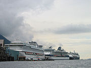
and tourism
Tourism
Tourism is travel for recreational, leisure or business purposes. The World Tourism Organization defines tourists as people "traveling to and staying in places outside their usual environment for not more than one consecutive year for leisure, business and other purposes".Tourism has become a...
(primarily the cruise ship industry). Logging
Logging
Logging is the cutting, skidding, on-site processing, and loading of trees or logs onto trucks.In forestry, the term logging is sometimes used in a narrow sense concerning the logistics of moving wood from the stump to somewhere outside the forest, usually a sawmill or a lumber yard...
has been an important industry in the past, but has been steadily declining with competition from other areas and the closure of the region's major pulp mills.
History
The border between the Canadian province of British ColumbiaBritish Columbia
British Columbia is the westernmost of Canada's provinces and is known for its natural beauty, as reflected in its Latin motto, Splendor sine occasu . Its name was chosen by Queen Victoria in 1858...
and Alaska is known as the Alaska boundary dispute
Alaska Boundary Dispute
The Alaska boundary dispute was a territorial dispute between the United States and Canada . It was resolved by arbitration in 1903. The dispute had been going on between the Russian and British Empires since 1821, and was inherited by the United States as a consequence of the Alaska Purchase in...
, where the United States, Canada and the United Kingdom
United Kingdom
The United Kingdom of Great Britain and Northern IrelandIn the United Kingdom and Dependencies, other languages have been officially recognised as legitimate autochthonous languages under the European Charter for Regional or Minority Languages...
and British Columbia claimed different borderlines at the Alaskan Panhandle. While the British foreign affairs were in favour of support of the Canadian argument, the event resulted in what was thought of as a betrayal, leading to alienation of the British from the new nation of Canada.
Transportation
Due to the extremely rugged, mountainous nature of Southeastern Alaska, almost all communities (with the exception of Hyder, Skagway, and Haines) have no road connections outside of their locale, so aircraft and boats are the major means of transport. The Alaska Marine HighwayAlaska Marine Highway
The Alaska Marine Highway or the Alaska Marine Highway System is a ferry service operated by the government of the U.S. state of Alaska. It has its headquarters in Ketchikan, Alaska....
passes through this region.
Air transportation
Alaska AirlinesAlaska Airlines
Alaska Airlines is an airline based in the Seattle suburb of SeaTac, Washington in the United States. The airline originated in 1932 as McGee Airways. After many mergers with and acquisitions of other airlines, including Star Air Service, it became known as Alaska Airlines in 1944...
is by far the largest air carrier in the region, with Juneau's Juneau International Airport
Juneau International Airport
Juneau International Airport is a public-use airport and seaplane base located seven nautical miles northwest of the central business district of Juneau, a city and borough in the U.S. state of Alaska...
serving as the aerial hub for all of Southeast and Ketchikan's Ketchikan International Airport
Ketchikan International Airport
Ketchikan International Airport is a state-owned public-use airport located one nautical mile west of the central business district of Ketchikan, a city in Ketchikan Gateway Borough in the U.S. state of Alaska....
serving as a secondary hub for southern Southeast Alaska. Alaska's bush airlines and air taxi
Air taxi
An air taxi is an air charter passenger or cargo aircraft which operates on an on-demand basis.-Regulation:In the United States, air taxi and air charter operations are governed by Part 135 of the Federal Aviation Regulations , unlike the larger scheduled air carriers which are governed by more...
s serve many of the smaller and more isolated communities and villages in the regions.
Marine transportation
Southeast Alaska is primarily served by the state-run Alaska Marine Highway and secondarily by the Prince of Wales Island-based Inter-Island Ferry AuthorityInter-Island Ferry Authority
The Inter-Island Ferry Authority is a ferry service in the U.S. state of Alaska with its headquarters based in Craig on Prince of Wales Island.-History:...
. Small companies like Sitka-based Allen Marine and other independent operators in the Lynn Canal
Lynn Canal
Lynn Canal is an inlet into the mainland of southeast Alaska.Lynn Canal runs about from the inlets of the Chilkat River south to Chatham Strait and Stephens Passage...
occasionally also offer marine passenger service. Ship traffic in the area is seasonally busy with cruise ship
Cruise ship
A cruise ship or cruise liner is a passenger ship used for pleasure voyages, where the voyage itself and the ship's amenities are part of the experience, as well as the different destinations along the way...
s.
External links
- The regional economy of southeast Alaska: final report / prepared for Alaska Conservation Foundation; prepared by Steve Colt, Darcy Dugan, Ginny Fay (EcoSystems). Hosted by Alaska State Publications Program.
- Southeast Alaska energy export study: final report / prepared for The Southeast Conference; by D. Hittle & Associates, Inc., in association with Commonwealth Associates, Inc. Hosted by the Alaska State Publications Program.
- Swan - Tyee intertie economic analysis / prepared for the Four Dam Pool Power Agency; prepared by CAI, Commonwealth Associates, Inc. Hosted by Alaska State Publications Program.