

History of the west coast of North America
Encyclopedia

Bering Strait
The Bering Strait , known to natives as Imakpik, is a sea strait between Cape Dezhnev, Chukotka Autonomous Okrug, Russia, the easternmost point of the Asian continent and Cape Prince of Wales, Alaska, USA, the westernmost point of the North American continent, with latitude of about 65°40'N,...
, or alternately along a now-submerged coastal plain, through the development of significant pre-Columbian cultures and population densities, to the arrival of the European
European ethnic groups
The ethnic groups in Europe are the various ethnic groups that reside in the nations of Europe. European ethnology is the field of anthropology focusing on Europe....
explorers and colonizers. The west coast of North America
North America
North America is a continent wholly within the Northern Hemisphere and almost wholly within the Western Hemisphere. It is also considered a northern subcontinent of the Americas...
today is home to some of the largest and most important companies in the world, as well as being a center of world culture.
Geography
As used in this article, the term "west coast of North America" means a contiguous region of that continent bordering the Pacific OceanPacific Ocean
The Pacific Ocean is the largest of the Earth's oceanic divisions. It extends from the Arctic in the north to the Southern Ocean in the south, bounded by Asia and Australia in the west, and the Americas in the east.At 165.2 million square kilometres in area, this largest division of the World...
: all or parts of the U.S. state
U.S. state
A U.S. state is any one of the 50 federated states of the United States of America that share sovereignty with the federal government. Because of this shared sovereignty, an American is a citizen both of the federal entity and of his or her state of domicile. Four states use the official title of...
s of Alaska
Alaska
Alaska is the largest state in the United States by area. It is situated in the northwest extremity of the North American continent, with Canada to the east, the Arctic Ocean to the north, and the Pacific Ocean to the west and south, with Russia further west across the Bering Strait...
, Washington, Oregon
Oregon
Oregon is a state in the Pacific Northwest region of the United States. It is located on the Pacific coast, with Washington to the north, California to the south, Nevada on the southeast and Idaho to the east. The Columbia and Snake rivers delineate much of Oregon's northern and eastern...
, and California
California
California is a state located on the West Coast of the United States. It is by far the most populous U.S. state, and the third-largest by land area...
; all or parts of British Columbia
British Columbia
British Columbia is the westernmost of Canada's provinces and is known for its natural beauty, as reflected in its Latin motto, Splendor sine occasu . Its name was chosen by Queen Victoria in 1858...
and the Yukon
Yukon
Yukon is the westernmost and smallest of Canada's three federal territories. It was named after the Yukon River. The word Yukon means "Great River" in Gwich’in....
in Canada
Canada
Canada is a North American country consisting of ten provinces and three territories. Located in the northern part of the continent, it extends from the Atlantic Ocean in the east to the Pacific Ocean in the west, and northward into the Arctic Ocean...
; all or part of the Mexican states
States of Mexico
The United Mexican States is a federal republic formed by 32 federal entities .According to the Constitution of 1917, the states of the federation are free and sovereign. Each state has their own congress and constitution, while the Federal District has only limited autonomy with a local Congress...
of Baja California
Baja California
Baja California officially Estado Libre y Soberano de Baja California is one of the 31 states which, with the Federal District, comprise the 32 Federal Entities of Mexico. It is both the northernmost and westernmost state of Mexico. Before becoming a state in 1953, the area was known as the North...
, Baja California Sur
Baja California Sur
Baja California Sur , is one of the 31 states which, with the Federal District, comprise the 32 Federal Entities of Mexico. Before becoming a state on October 8, 1974, the area was known as the South Territory of Baja California. It has an area of , or 3.57% of the land mass of Mexico and comprises...
, Sonora
Sonora
Sonora officially Estado Libre y Soberano de Sonora is one of the 31 states which, with the Federal District, comprise the 32 Federal Entities of Mexico. It is divided into 72 municipalities; the capital city is Hermosillo....
, Sinaloa
Sinaloa
Sinaloa officially Estado Libre y Soberano de Sinaloa is one of the 31 states which, with the Federal District, comprise the 32 Federal Entities of Mexico. It is divided in 18 municipalities and its capital city is Culiacán Rosales....
, Nayarit
Nayarit
Nayarit officially Estado Libre y Soberano de Nayarit is one of the 31 states which, with the Federal District, comprise the 32 Federal Entities of Mexico. It is divided in 20 municipalities and its capital city is Tepic.It is located in Western Mexico...
, Jalisco
Jalisco
Jalisco officially Estado Libre y Soberano de Jalisco is one of the 31 states which, with the Federal District, comprise the 32 Federal Entities of Mexico. It is located in Western Mexico and divided in 125 municipalities and its capital city is Guadalajara.It is one of the more important states...
, Colima
Colima
Colima is one of the 31 states which, with the Federal District, make up the 32 Federal Entities of Mexico. It shares its name with its capital and main city, Colima....
, Michoacan
Michoacán
Michoacán officially Estado Libre y Soberano de Michoacán de Ocampo is one of the 31 states which, with the Federal District, comprise the 32 Federal Entities of Mexico. It is divided in 113 municipalities and its capital city is Morelia...
, Guerrero
Guerrero
Guerrero officially Estado Libre y Soberano de Guerrero is one of the 31 states which, with the Federal District, comprise the 32 Federal Entities of Mexico. It is divided in 81 municipalities and its capital city is Chilpancingo....
, Oaxaca
Oaxaca
Oaxaca , , officially Estado Libre y Soberano de Oaxaca is one of the 31 states which, along with the Federal District, comprise the 32 federative entities of Mexico. It is divided into 571 municipalities; of which 418 are governed by the system of customs and traditions...
and Chiapas
Chiapas
Chiapas officially Estado Libre y Soberano de Chiapas is one of the 31 states that, with the Federal District, comprise the 32 Federal Entities of Mexico. It is divided in 118 municipalities and its capital city is Tuxtla Gutierrez. Other important cites in Chiapas include San Cristóbal de las...
; and the Central American
Central America
Central America is the central geographic region of the Americas. It is the southernmost, isthmian portion of the North American continent, which connects with South America on the southeast. When considered part of the unified continental model, it is considered a subcontinent...
countries of Guatemala
Guatemala
Guatemala is a country in Central America bordered by Mexico to the north and west, the Pacific Ocean to the southwest, Belize to the northeast, the Caribbean to the east, and Honduras and El Salvador to the southeast...
, El Salvador
El Salvador
El Salvador or simply Salvador is the smallest and the most densely populated country in Central America. The country's capital city and largest city is San Salvador; Santa Ana and San Miguel are also important cultural and commercial centers in the country and in all of Central America...
, Honduras
Honduras
Honduras is a republic in Central America. It was previously known as Spanish Honduras to differentiate it from British Honduras, which became the modern-day state of Belize...
, Nicaragua
Nicaragua
Nicaragua is the largest country in the Central American American isthmus, bordered by Honduras to the north and Costa Rica to the south. The country is situated between 11 and 14 degrees north of the Equator in the Northern Hemisphere, which places it entirely within the tropics. The Pacific Ocean...
, Costa Rica
Costa Rica
Costa Rica , officially the Republic of Costa Rica is a multilingual, multiethnic and multicultural country in Central America, bordered by Nicaragua to the north, Panama to the southeast, the Pacific Ocean to the west and the Caribbean Sea to the east....
and Panama
Panama
Panama , officially the Republic of Panama , is the southernmost country of Central America. Situated on the isthmus connecting North and South America, it is bordered by Costa Rica to the northwest, Colombia to the southeast, the Caribbean Sea to the north and the Pacific Ocean to the south. The...
. The eastern Islands of the Pacific Ocean off the west coast, such as the Coastal islands of the Californias, are also important.
First peoples
This region of North America likely saw the first sustained arrival of people to the continent. Although there are other theories, most scientists believe that the first significant groups of people came from AsiaAsia
Asia is the world's largest and most populous continent, located primarily in the eastern and northern hemispheres. It covers 8.7% of the Earth's total surface area and with approximately 3.879 billion people, it hosts 60% of the world's current human population...
, through today's Bering Strait
Bering Strait
The Bering Strait , known to natives as Imakpik, is a sea strait between Cape Dezhnev, Chukotka Autonomous Okrug, Russia, the easternmost point of the Asian continent and Cape Prince of Wales, Alaska, USA, the westernmost point of the North American continent, with latitude of about 65°40'N,...
area, then through modern Alaska, and from there spread throughout North America and to South America
South America
South America is a continent situated in the Western Hemisphere, mostly in the Southern Hemisphere, with a relatively small portion in the Northern Hemisphere. The continent is also considered a subcontinent of the Americas. It is bordered on the west by the Pacific Ocean and on the north and east...
.
Although the cultures on the west coast of today's Canada and United States are not known to have developed substantial urban centers and sophisticated writing or scientific systems, it is likely that, before European contact, the population density along the west coast of today's Canada and United States was significantly higher than in the rest of the northern part of the continent. For example, it has been estimated that in 1492, one-third of all Native Americans in the United States
Native Americans in the United States
Native Americans in the United States are the indigenous peoples in North America within the boundaries of the present-day continental United States, parts of Alaska, and the island state of Hawaii. They are composed of numerous, distinct tribes, states, and ethnic groups, many of which survive as...
were living in California.
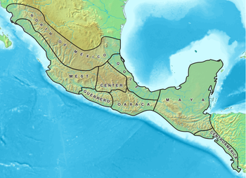
Mesoamerica
Mesoamerica is a region and culture area in the Americas, extending approximately from central Mexico to Belize, Guatemala, El Salvador, Honduras, Nicaragua, and Costa Rica, within which a number of pre-Columbian societies flourished before the Spanish colonization of the Americas in the 15th and...
(that is, western portions of today's Mexico and northern Central America
Central America
Central America is the central geographic region of the Americas. It is the southernmost, isthmian portion of the North American continent, which connects with South America on the southeast. When considered part of the unified continental model, it is considered a subcontinent...
), the oldest settlements date to approximately 2000 BCE. A succession of cultures
Mesoamerican chronology
Mesoamerican chronology divides the history of pre-Columbian Mesoamerica into several periods: the Paleo-Indian , the Archaic , the Preclassic , the Classic , and the Postclassic...
started with the very early Capacha culture, which appeared on the Pacific coast of modern Mexico about 1450 BC and spread into the interior. The following cultures developed into "high civilizations" in Mesoamerica, with extensive urban areas, writing, astronomy and fine arts:
- OlmecOlmecThe Olmec were the first major Pre-Columbian civilization in Mexico. They lived in the tropical lowlands of south-central Mexico, in the modern-day states of Veracruz and Tabasco....
(beginning about 1150 BC) - MixtecMixtecThe Mixtec are indigenous Mesoamerican peoples inhabiting the Mexican states of Oaxaca, Guerrero and Puebla in a region known as La Mixteca. The Mixtecan languages form an important branch of the Otomanguean language family....
(beginning perhaps 1000 BC) - MayaMaya civilizationThe Maya is a Mesoamerican civilization, noted for the only known fully developed written language of the pre-Columbian Americas, as well as for its art, architecture, and mathematical and astronomical systems. Initially established during the Pre-Classic period The Maya is a Mesoamerican...
(settled villages along the Pacific coast appear from 1800 BC, and ceremonial architecture by approximately 1000 BC) and - AztecAztecThe Aztec people were certain ethnic groups of central Mexico, particularly those groups who spoke the Nahuatl language and who dominated large parts of Mesoamerica in the 14th, 15th and 16th centuries, a period referred to as the late post-classic period in Mesoamerican chronology.Aztec is the...
(from the 14th century AD)
Farther south, Panama was home to some of the earliest pottery-making, such as the Monagrillo culture dating to about 2500–1700 BC; this culture evolved into significant populations best known for spectacular burial sites (dating to c. 500–900 AD) and polychrome pottery of the Coclé style.
Each of these cultures rose, flourished, and was then conquered by a more militarily developed culture. While not all of these civilizations had large settlements along the coast of the Pacific Ocean, their influence extended to the Pacific coast.
European arrival (1513–1750)
In 1513, SpanishHistory of Spain
The history of Spain involves all the other peoples and nations within the Iberian peninsula formerly known as Hispania, and includes still today the nations of Andorra, Gibraltar, Portugal and Spain...
explorers were the first Europeans to reach the west coast of North America, on the Pacific coast of the Panama isthmus. From the point of view of European powers in the age of sailing ships, the west coast of North America was among the most distant places in the world. The arduous journey around Cape Horn
Cape Horn
Cape Horn is the southernmost headland of the Tierra del Fuego archipelago of southern Chile, and is located on the small Hornos Island...
at the tip of South America and then north meant nine to twelve months of dangerous sailing. These practical difficulties discouraged all but the Spanish Empire
Spanish Empire
The Spanish Empire comprised territories and colonies administered directly by Spain in Europe, in America, Africa, Asia and Oceania. It originated during the Age of Exploration and was therefore one of the first global empires. At the time of Habsburgs, Spain reached the peak of its world power....
from making regular visits and establishing settlements and ports until the second half of the 18th century—some 200 years after Europeans first reached the east coast of North America.
Spanish explorers and conquistadors
Explorers flying the flag of SpainSpain
Spain , officially the Kingdom of Spain languages]] under the European Charter for Regional or Minority Languages. In each of these, Spain's official name is as follows:;;;;;;), is a country and member state of the European Union located in southwestern Europe on the Iberian Peninsula...
reached the New World
New World
The New World is one of the names used for the Western Hemisphere, specifically America and sometimes Oceania . The term originated in the late 15th century, when America had been recently discovered by European explorers, expanding the geographical horizon of the people of the European middle...
beginning on 1492 with the discovery of America by Christopher Columbus
Christopher Columbus
Christopher Columbus was an explorer, colonizer, and navigator, born in the Republic of Genoa, in northwestern Italy. Under the auspices of the Catholic Monarchs of Spain, he completed four voyages across the Atlantic Ocean that led to general European awareness of the American continents in the...
. Spanish expeditions colonized and explored vast areas in North and South America following the grants of the Pope (contained in the 1493 papal bull Inter caetera
Inter caetera
Inter caetera was a papal bull issued by Pope Alexander VI on , which granted to Spain all lands to the "west and south" of a pole-to-pole line 100 leagues west and south of any of the islands of the Azores or the Cape Verde Islands.It remains unclear to the present whether the pope was issuing a...
) and rights contained in the 1494 Treaty of Tordesillas
Treaty of Tordesillas
The Treaty of Tordesillas , signed at Tordesillas , , divided the newly discovered lands outside Europe between Spain and Portugal along a meridian 370 leagueswest of the Cape Verde islands...
and 1529 Treaty of Zaragoza. These formal acts gave Spain the exclusive rights to colonize the entire Western Hemisphere (excluding eastern Brazil
Brazil
Brazil , officially the Federative Republic of Brazil , is the largest country in South America. It is the world's fifth largest country, both by geographical area and by population with over 192 million people...
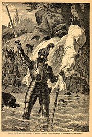
), including all of the west coast of North America. The first European expedition to actually reach the west coast was led by the Spaniard Vasco Núñez de Balboa
Vasco Núñez de Balboa
Vasco Núñez de Balboa was a Spanish explorer, governor, and conquistador. He is best known for having crossed the Isthmus of Panama to the Pacific Ocean in 1513, becoming the first European to lead an expedition to have seen or reached the Pacific from the New World.He traveled to the New World in...
, who reached the Pacific coast of Panama
Panama
Panama , officially the Republic of Panama , is the southernmost country of Central America. Situated on the isthmus connecting North and South America, it is bordered by Costa Rica to the northwest, Colombia to the southeast, the Caribbean Sea to the north and the Pacific Ocean to the south. The...
in 1513. In an act of enduring historical importance, Balboa claimed the Pacific Ocean for the Spanish Crown, as well as all adjoining land and islands. This act gave Spain exclusive sovereignty and navigation rights over the entire west coast of North America.
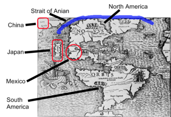
Northwest Passage
The Northwest Passage is a sea route through the Arctic Ocean, along the northern coast of North America via waterways amidst the Canadian Arctic Archipelago, connecting the Atlantic and Pacific Oceans...
, known as the Strait of Anián, which some believed reached the Pacific Ocean at 42° north latitude (the latitude of today's border between Oregon and California) and connected to the Atlantic Ocean
Atlantic Ocean
The Atlantic Ocean is the second-largest of the world's oceanic divisions. With a total area of about , it covers approximately 20% of the Earth's surface and about 26% of its water surface area...
at the Gulf of St. Lawrence. Confirmation of the land connection, and discovery of this Strait of Anián, were key elements in Spain's efforts to establish direct trade routes with China
China
Chinese civilization may refer to:* China for more general discussion of the country.* Chinese culture* Greater China, the transnational community of ethnic Chinese.* History of China* Sinosphere, the area historically affected by Chinese culture...
and other countries in Asia.
The Pacific Coast of Mexico and Central America was not especially conducive to economic development during this era. The northern Mexican coast (including the Baja California Peninsula
Baja California Peninsula
The Baja California peninsula , is a peninsula in northwestern Mexico. Its land mass separates the Pacific Ocean from the Gulf of California. The Peninsula extends from Mexicali, Baja California in the north to Cabo San Lucas, Baja California Sur in the south.The total area of the Baja California...
) was generally too dry for substantial agriculture or ranching that would support settlements. South of the deserts, the jungles of the Pacific Coast in Mexico and Central America, and the tropical diseases found there, were major obstacles to large-scale development.
Important exceptions were the development of important Spanish ports at Puerto de Navidad
Barra de Navidad
Barra de Navidad is a small town located on the western coast-line of the Mexican state of Jalisco.The town of Barra de Navidad with a population of 7000+ is a small farming and fishing community located on the east end of the Bahía de Navidad, 60 km north of Manzanillo...
and Acapulco
Acapulco
Acapulco is a city, municipality and major sea port in the state of Guerrero on the Pacific coast of Mexico, southwest from Mexico City. Acapulco is located on a deep, semi-circular bay and has been a port since the early colonial period of Mexico’s history...
in today's Mexico. While Navidad faded in importance, Acapulco became the primary port of the Spanish Empire
Spanish Empire
The Spanish Empire comprised territories and colonies administered directly by Spain in Europe, in America, Africa, Asia and Oceania. It originated during the Age of Exploration and was therefore one of the first global empires. At the time of Habsburgs, Spain reached the peak of its world power....
on the west coast of North America, and was used as a base for exploratory expeditions north and trade routes with the Far East.

Conquistador
Conquistadors were Spanish soldiers, explorers, and adventurers who brought much of the Americas under the control of Spain in the 15th to 16th centuries, following Europe's discovery of the New World by Christopher Columbus in 1492...
Hernán Cortés
Hernán Cortés
Hernán Cortés de Monroy y Pizarro, 1st Marquis of the Valley of Oaxaca was a Spanish Conquistador who led an expedition that caused the fall of the Aztec Empire and brought large portions of mainland Mexico under the rule of the King of Castile in the early 16th century...
personally sponsored and financed exploratory sailing voyages north from Acapulco, in a search for legendary riches reported to be in the site of today's California. In the third of these voyages, Cortés accompanied the voyage, and likely reached the site of today's La Paz
La Paz, Baja California Sur
La Paz is the capital city of the Mexican state of Baja California Sur and an important regional commercial center. The city had a 2010 census population of 215,178 persons, but its metropolitan population is somewhat larger because of surrounding towns like el Centenario, el Zacatal and San Pedro...
on the Baja California peninsula.
In 1539, another voyage financed and sponsored by Cortés, and led by Francisco de Ulloa
Francisco de Ulloa
Francisco de Ulloa was a Spanish explorer who explored the west coast of present-day Mexico under the commission of Hernán Cortés...
, embarked on an expedition in three small vessels, sailing north from Acapulco
Acapulco
Acapulco is a city, municipality and major sea port in the state of Guerrero on the Pacific coast of Mexico, southwest from Mexico City. Acapulco is located on a deep, semi-circular bay and has been a port since the early colonial period of Mexico’s history...
to explore the Pacific Coast, and to seek the Strait of Anián. The expedition sailed northwards along the west coast of the Mexican mainland, and reached the Gulf of California
Gulf of California
The Gulf of California is a body of water that separates the Baja California Peninsula from the Mexican mainland...
six weeks later. Ulloa named the Gulf the "Sea of Cortés" in honor of his patron. When one of his ships was lost in a storm, Ulloa paused to repair the other two ships, and then resumed his voyage, eventually reaching the northern end of the Gulf. Unable to find the Strait of Anián, Ulloa turned south and sailed along the eastern coast of the Baja California peninsula
Baja California Peninsula
The Baja California peninsula , is a peninsula in northwestern Mexico. Its land mass separates the Pacific Ocean from the Gulf of California. The Peninsula extends from Mexicali, Baja California in the north to Cabo San Lucas, Baja California Sur in the south.The total area of the Baja California...
, landing at the Bay of La Paz. After taking on supplies of wood and water, Ulloa rounded the tip of the peninsula with great difficulty and sailed northward along the western shore of the peninsula, in the Pacific Ocean. The progress of his small ships was hampered by the fierce winds and high seas he encountered, eventually forcing him to turn back to Acapulco. The voyage eventually reached 28° north latitude (near the Isla de Cedros).
Voyages in 1540 and 1541 to Baja California were sponsored by Cortés's rival, the Viceroy of New Spain
New Spain
New Spain, formally called the Viceroyalty of New Spain , was a viceroyalty of the Spanish colonial empire, comprising primarily territories in what was known then as 'América Septentrional' or North America. Its capital was Mexico City, formerly Tenochtitlan, capital of the Aztec Empire...
. These voyages were led by Hernando de Alarcón
Hernando de Alarcón
Hernando de Alarcón, a Spanish navigator of the 16th century, noted for having led an early expedition to the Baja California peninsula, meant to be coordinated with Francisco Vasquéz de Coronado's overland expedition, and for penetrating the lower Colorado River, perhaps as far as the modern...
(1540) and by Francisco de Bolaños (1541). The voyage by Alarcón was meant to be coordinated with Francisco Vásquez de Coronado
Francisco Vásquez de Coronado
Francisco Vásquez de Coronado y Luján was a Spanish conquistador, who visited New Mexico and other parts of what are now the southwestern United States between 1540 and 1542...
's overland expedition; Alarcón penetrated the lower Colorado River, perhaps as far as the modern California-Arizona boundary (but did not meet up with Coronado's expedition). The voyage of Bolaños provided little new information not already known in New Spain. Application of the name California
Origin of the name California
California is a place name used by three North American states: in the United States by the state of California, and in Mexico by the states of Baja California and Baja California Sur. Collectively, these three areas constitute the region formerly referred to as Las Californias...
to this part of the west coast of North America is attributed by some to Bolaños, however other insist that the name first appears in work written by Alarcón.
The governor of Guatemala
Guatemala
Guatemala is a country in Central America bordered by Mexico to the north and west, the Pacific Ocean to the southwest, Belize to the northeast, the Caribbean to the east, and Honduras and El Salvador to the southeast...
also determined to build a Pacific fleet on the west coast of Guatemala, for use in an attempt to cross the Pacific to Asia. Ferdinand Magellan
Ferdinand Magellan
Ferdinand Magellan was a Portuguese explorer. He was born in Sabrosa, in northern Portugal, and served King Charles I of Spain in search of a westward route to the "Spice Islands" ....
, the Portuguese explorer sailing for Spain, had shown in 1521 that the Pacific Ocean could be crossed from South America. Hence, beginning in 1536, using hardware from Spain (such as anchors) hauled across the isthmus of Central America, and local hardwoods, a flotilla of some thirteen ships was built over the next four years. After much difficulty, the larger number of these ships (under the command of Ruy López de Villalobos
Ruy López de Villalobos
Ruy López de Villalobos was a Spanish explorer who sailed the Pacific from Mexico to establish a permanent foothold for Spain in the East Indies, which was near the Line of Demarcation between Spain and Portugal according to the Treaty of Saragossa in 1529...
) was ordered to make the first crossing of the Pacific Ocean from North America to the Philippines
Philippines
The Philippines , officially known as the Republic of the Philippines , is a country in Southeast Asia in the western Pacific Ocean. To its north across the Luzon Strait lies Taiwan. West across the South China Sea sits Vietnam...
. A smaller number was placed under the command of Juan Rodríguez Cabrillo
Juan Rodríguez Cabrillo
Juan Rodriguez Cabrillo was a Portuguese explorer noted for his exploration of the west coast of North America on behalf of Spain. Cabrillo was the first European explorer to navigate the coast of present day California in the United States...
, a Portuguese navigator sailing for the Spanish Crown. Cabrillo was ordered north along the west coast of North America to explore the expected coastal route to reach the Asian mainland, as well as attempt to find the Strait of Anián.
In 1542, Cabrillo became the first European to explore the west coast of today's United States, leading the expedition that landed at San Diego Bay
San Diego Bay
San Diego Bay is a natural harbor and deepwater port adjacent to San Diego, California. It is 12 mi/19 km long, 1 mi/1.6 km–3 mi/4.8 km wide...
, and continued north. But Cabrillo died during this voyage, and the remainder of the exploration was led by Bartolomé Ferrelo
Bartolomé Ferrelo
Bartolomé Ferrelo, also known as Bartolomé Ferrer, born 1499 in Bilbao Spain, died 1550 in Mexico.He was the pilot for Juan Rodrigo Cabrillo, the Portuguese captain who was sent by the viceroy of Mexico, with two ships in 1542 to explore what is now Northern California...
, who sailed perhaps as far north as the Rogue River
Rogue River (Oregon)
The Rogue River in southwestern Oregon in the United States flows about in a generally westward direction from the Cascade Range to the Pacific Ocean. Known for its salmon runs, whitewater rafting, and rugged scenery, it was one of the original eight rivers named in the Wild and Scenic Rivers Act...
in today's western coast of Oregon.
Importantly beginning in 1565, Acapulco was a home of the vital Manila Galleons. The Manila Galleons crossed the Pacific Ocean to the Spanish possession of the Philippines
Philippines
The Philippines , officially known as the Republic of the Philippines , is a country in Southeast Asia in the western Pacific Ocean. To its north across the Luzon Strait lies Taiwan. West across the South China Sea sits Vietnam...
, laden with silver and gemstones from Mexico. There, the wealth was used to purchase Asian trade goods such as spices, silk
Silk
Silk is a natural protein fiber, some forms of which can be woven into textiles. The best-known type of silk is obtained from the cocoons of the larvae of the mulberry silkworm Bombyx mori reared in captivity...
, and porcelain
Porcelain
Porcelain is a ceramic material made by heating raw materials, generally including clay in the form of kaolin, in a kiln to temperatures between and...
. These goods were then carried across the Pacific by the Manila Galleons to Acapulco; from there, the goods were transshipped across Mexico, for delivery to the Spanish treasure fleet
Spanish treasure fleet
The Spanish treasure fleets was a convoy system adopted by the Spanish Empire from 1566 to 1790...
, for shipment to Spain. The income provided to Spain by the Manila Galleons was essential to the Spanish Crown and to the Spanish economy of the era.
When Miguel López de Legazpi
Miguel López de Legazpi
Miguel López de Legazpi , also known as El Adelantado and El Viejo , was a Spanish conquistador who established one of the first European settlements in the East Indies and the Pacific Islands in 1565. He is the first Governor-General in the Philippines...
completed the conquest of the Philippines in 1565, he sent his flagship, the San Pedro, back to New Spain, with orders to survey and chart a practicable route for ships returning from the Islands. The San Pedro sailed from Cebu
Cebu
Cebu is a province in the Philippines, consisting of Cebu Island and 167 surrounding islands. It is located to the east of Negros, to the west of Leyte and Bohol islands...
, headed roughly northeast, followed the Kuroshio Current
Kuroshio Current
The Kuroshio is a north-flowing ocean current on the west side of the North Pacific Ocean. It is similar to the Gulf Stream in the North Atlantic and is part of the North Pacific ocean gyre...
(also known as the Japan Current), and made landfall on the coast of California about the latitude of Cape Mendocino
Cape Mendocino
Cape Mendocino located on the Lost Coast entirely within Humboldt County, California, USA, is the westernmost point on the coast of California. It has been a landmark since the 16th century when the Manila Galleons would reach the coast here following the prevailing westerlies all the way across...
. A sail of two thousand five hundred miles down the coasts of California and New Spain brought the voyagers to the port of Acapulco. This route was charted by the Basque navigator and friar Andrés de Urdaneta
Andrés de Urdaneta
Friar Andrés de Urdaneta, O.S.A., was a circumnavigator, explorer and Augustinian friar. As a navigator he achieved in 1536 the "second" world circumnavigation after first one led by Ferdinand Magellan and Juan Sebastián Elcano in 1522...
, on board the San Pedro, and for nearly three centuries was the one followed by the galleons of Spain sailing from Manila to Acapulco. This return voyage across the Pacific could take up to seven months. A harbor on the coast of California where ships could find shelter and repair damage was greatly desired. A survey of the unknown northern Pacific coast of North America was ordered, and it was also suggested that the explorations be extended north of 42° north latitude.
In 1585, Captain Francisco de Gali, on the return voyage from the Philippines, was directed to sail as far north as the weather would permit, and then east, and upon reaching the coast of California to make maps on his journey south. However, Gali accomplished only limited chart-making. He reached the California coast at latitude 37° 30' (Pillar Point—just south of today's San Francisco
San Francisco, California
San Francisco , officially the City and County of San Francisco, is the financial, cultural, and transportation center of the San Francisco Bay Area, a region of 7.15 million people which includes San Jose and Oakland...
), and noted that the land was high and fair; that the mountains were without snow, and that there were many indications of rivers, bays, and havens along the coast.
In 1594, Captain Sebastian Cermeñon, a Portuguese sailor in the service of Spain, sailed from the Philippines in the San Agustin with orders similar to those of Gali. In this attempt, Cermeñon's ship became wrecked and was beached in Drake's Bay, north of San Francisco. Using salvaged and local materials, the crew constructed an open boat, and the ship's company of more than seventy persons continued the homeward voyage. This open vessel reached Acapulco in early 1596—a remarkable voyage of nearly twenty-five hundred miles in an open boat. With the loss of the San Agustin, exploration of the California coast by ships loaded with cargo from the Philippines came to an end.
In 1602, the Basque captain Sebastián Vizcaíno
Sebastián Vizcaíno
Sebastián Vizcaíno was a Spanish soldier, entrepreneur, explorer, and diplomat whose varied roles took him to New Spain, the Philippines, the Baja California peninsula, the California coast and Japan.-Early career:...
, sailing for Spain, explored the coastline from Mexico as far north as Monterey Bay
Monterey Bay
Monterey Bay is a bay of the Pacific Ocean, along the central coast of California. The bay is south of San Francisco and San Jose, between the cities of Santa Cruz and Monterey....
in today's California, where he went ashore. He ventured inland south along the coast, and recorded a visit to what is likely Carmel Bay. His major contributions were the glowing reports of the Monterey area as an anchorage and as land suitable for settlement, as well as the detailed charts he made of the coastal waters (which were used for nearly 200 years); however no settlements in today's California were established for the next 150 years.
In the late 17th century, Spain sent the first missionaries into today's Baja California
Baja California Peninsula
The Baja California peninsula , is a peninsula in northwestern Mexico. Its land mass separates the Pacific Ocean from the Gulf of California. The Peninsula extends from Mexicali, Baja California in the north to Cabo San Lucas, Baja California Sur in the south.The total area of the Baja California...
, founding the first mission
Spanish missions in Baja California
The Spanish Missions in Baja California comprise a series of religious outposts established by Spanish Catholic religious orders, the Jesuits, the Franciscans and the Dominicans, between 1683 and 1834 to spread the Christian doctrine among the local natives...
there in 1683 at San Bruno
Misión San Bruno
The short-lived Jesuit mission of San Bruno was established in 1683 on the Gulf of California of Baja California Sur, about 20 kilometers north of the later site of the town of Loreto....
on the east coast of the Baja peninsula (San Bruno was abandoned as unsuccessful after two years). In 1697, the first "permanent" mission was established at Loreto
Misión de Nuestra Señora de Loreto Conchó
Misión de Nuestra Señora de Loreto Conchó, or Mission Loreto, was founded on October 25, 1697 at the Monqui settlement of Conchó in the present city of Loreto, Baja California Sur, Mexico...
, about 20 miles (32.2 km) away from San Bruno, also on the east coast of the peninsula. During this period (until 1750), some 16 missions were established on the peninsula—mostly on the east coast of the peninsula, with a handful on the Pacific coast, in the northwestern part of the peninsula.
English interest
Although it wasn't until 1579 that the west coast of North America was visited by an English explorer, the privateerPrivateer
A privateer is a private person or ship authorized by a government by letters of marque to attack foreign shipping during wartime. Privateering was a way of mobilizing armed ships and sailors without having to spend public money or commit naval officers...
Sir Francis Drake who landed north of today's San Francisco and claimed the area for England
England
England is a country that is part of the United Kingdom. It shares land borders with Scotland to the north and Wales to the west; the Irish Sea is to the north west, the Celtic Sea to the south west, with the North Sea to the east and the English Channel to the south separating it from continental...
, calling it "New Albion
New Albion
New Albion, also known as Nova Albion, was the name of the region of the Pacific coast of North America explored by Sir Francis Drake and claimed by him for England in 1579...
" or New England, the English claim to this territory dates back to John Cabot
John Cabot
John Cabot was an Italian navigator and explorer whose 1497 discovery of parts of North America is commonly held to have been the first European encounter with the continent of North America since the Norse Vikings in the eleventh century...
's landing on Americas. The exact location of Drake's landing has never been determined, and the extent of Drake's claim is unknown. The most commonly accepted location is at Drake's Estero (also known as "Drake's Bay," just north of San Francisco, in Marin County). However, other candidates include Bolinas Bay
Bolinas Bay
Bolinas Bay is a small bay, approximately 5 miles wide, on the Pacific coast of California in the United States. It is in Marin County, north of the Golden Gate, approximately 15 miles northwest of San Francisco...
and Campbell Cove at the entrance of Bodega Harbor
Bodega Harbor
Bodega Harbor is a small shallow natural harbor on the Pacific coast of northern California in the United States, approximately 40 mi northwest of San Francisco...
in Northern California
Northern California
Northern California is the northern portion of the U.S. state of California. The San Francisco Bay Area , and Sacramento as well as its metropolitan area are the main population centers...
, as well as sites in Oregon and British Columbia. Despite the facts that no permanent settlements were ever established by Drake, and that the next official visit by the British would be some two hundred years later, Drake's action and Cabot's original claim in 1497 were the foundations of British claims to portions of the west coast of North America in the late 18th century.
Settlements and conflicts (1750–1846)
While the Spanish had dominated development on the west coast of North America for over 200 years since the early 16th century, beginning in the mid-18th century, this period saw the advent of BritishBritish Empire
The British Empire comprised the dominions, colonies, protectorates, mandates and other territories ruled or administered by the United Kingdom. It originated with the overseas colonies and trading posts established by England in the late 16th and early 17th centuries. At its height, it was the...
and Russian
Russian Empire
The Russian Empire was a state that existed from 1721 until the Russian Revolution of 1917. It was the successor to the Tsardom of Russia and the predecessor of the Soviet Union...
rivals, and the establishment of the California missions, followed by the independence of Mexico and the Central American countries. Much later in this period, the United States
United States
The United States of America is a federal constitutional republic comprising fifty states and a federal district...
started on its path to become the dominant power on the west coast of North America.
Spanish settlements in coastal New Spain
In the 1760s, a decision was made to create a harbor at San BlasSan Blas, Nayarit
San Blas is both a municipality and municipal seat located on the Pacific coast of Mexico in the state of Nayarit.-City:San Blas is a port and a popular tourist destination, located about 100 miles north of Puerto Vallarta, and 40 miles west of the state capital Tepic. The town has a population of...
(in today's Mexican state of Nayarit
Nayarit
Nayarit officially Estado Libre y Soberano de Nayarit is one of the 31 states which, with the Federal District, comprise the 32 Federal Entities of Mexico. It is divided in 20 municipalities and its capital city is Tepic.It is located in Western Mexico...
), for the purpose of building ships, supplying them, and being the expeditionary base for voyages north along the west coast of North America, from Baja California to Alaska. Today it remains unclear exactly why the Viceroy of New Spain
New Spain
New Spain, formally called the Viceroyalty of New Spain , was a viceroyalty of the Spanish colonial empire, comprising primarily territories in what was known then as 'América Septentrional' or North America. Its capital was Mexico City, formerly Tenochtitlan, capital of the Aztec Empire...
decided to create an entirely new shipbuilding port along the west coast of Mexico, when the port at Acapulco already existed. It has been speculated that the reasons San Blas was chosen included that it was a week's sailing closer than Acapulco to the intended destination sites in California, that it was not far from the capital of New Spain, and perhaps more importantly, it had ready access to tropical hardwoods that would be needed to build the ships for the strenuous voyages as far north as today's Alaska. San Blas built the ships and was the home port for these exploration and supply voyages beginning in 1769 and continuing to 1820.
Spanish missions
It was not until 1769, that the first missions were established in today's California (then called Las CaliforniasLas Californias
The Californias, or in — - was the name given by the Spanish to their northwestern territory of New Spain, comprising the present day states of Baja California and Baja California Sur on the Baja California Peninsula in Mexico; and the present day U.S. state of California in the United States of...
), including the first mission
Mission San Diego de Alcalá
Mission Basilica San Diego de Alcalá, in San Diego, California, was the first Franciscan mission in the Las Californias Province of the Viceroyalty of New Spain. It was founded in 1769 by Spanish friar Junípero Serra in an area long inhabited by the Kumeyaay Indians...
, at San Diego in 1769, the mission
Mission San Carlos Borromeo de Carmelo
Mission San Carlos Borroméo del río Carmelo, also known as the Carmel Mission, is a Roman Catholic mission church in Carmel, California. It is on the National Register of Historic Places and a U.S...
at Monterey in 1770, and the mission
Mission San Francisco de Asís
Mission San Francisco de Asís, or Mission Dolores, is the oldest surviving structure in San Francisco and the sixth religious settlement established as part of the California chain of missions...
at San Francisco in 1776. These missions eventually stretched from the southern tip of the Baja California peninsula to Sonoma, California
Sonoma, California
Sonoma is a historically significant city in Sonoma Valley, Sonoma County, California, USA, surrounding its historic town plaza, a remnant of the town's Mexican colonial past. It was the capital of the short-lived California Republic...
, north of San Francisco. The purpose of the missions, which typically had an accompanying pueblo (town) and presidio (military outpost), was to solidify the 250-year-old Spanish claim to the region. This need became more urgent as the Russians and British were encroaching on the far northern part of the west coast of North America. In addition, there continued the long-standing interest in creating a safe anchorage for seaworn Manila Galleons on their return to Acapulco
Acapulco
Acapulco is a city, municipality and major sea port in the state of Guerrero on the Pacific coast of Mexico, southwest from Mexico City. Acapulco is located on a deep, semi-circular bay and has been a port since the early colonial period of Mexico’s history...
.
Russian settlements
Explorers and fur trappers from the Russian EmpireRussian Empire
The Russian Empire was a state that existed from 1721 until the Russian Revolution of 1917. It was the successor to the Tsardom of Russia and the predecessor of the Soviet Union...
(beginning with the Vitus Bering
Vitus Bering
Vitus Jonassen Bering Vitus Jonassen Bering Vitus Jonassen Bering (also, less correNavy]], a captain-komandor known among the Russian sailors as Ivan Ivanovich. He is noted for being the first European to discover Alaska and its Aleutian Islands...
expedition of 1741) arrived on the Pacific coast of today's Alaska, and after establishing settlements there (beginning in 1784), expanded hunting and trading down the west coast of North America. In the early 19th century, fur trappers of the Russian Empire explored the west coast of North America, hunting for sea otter pelts as far south as San Diego. In 1812, the Russian-American Company
Russian-American Company
The Russian-American Company was a state-sponsored chartered company formed largely on the basis of the so-called Shelekhov-Golikov Company of Grigory Shelekhov and Ivan Larionovich Golikov The Russian-American Company (officially: Under His Imperial Majesty's Highest Protection (patronage)...
set up a fortified trading post at Fort Ross, near present day Bodega Bay
Bodega Bay
Bodega Bay is a shallow, rocky inlet of the Pacific Ocean on the coast of northern California in the United States. It is approximately across and is located approximately northwest of San Francisco and west of Santa Rosa...
some sixty miles north of San Francisco.
Spanish exploration
In the late 18th century, Spain reacted to the expanding Russian and British presence in the Pacific NorthwestPacific Northwest
The Pacific Northwest is a region in northwestern North America, bounded by the Pacific Ocean to the west and, loosely, by the Rocky Mountains on the east. Definitions of the region vary and there is no commonly agreed upon boundary, even among Pacific Northwesterners. A common concept of the...
by sending exploratory expeditions along the coast as far north as Alaska. In 1775, a two-ship exploration expedition led by Spanish Captain Don Bruno de Heceta landed on the coast of today's Washington—the first European to have sailed this far north along the coast. The expedition re-asserted Spanish claims to all the coastal lands, including to the Russian settlements in the north. The two ships sailed together as far north as Point Grenville, named Punta de los Martires (or "Point of the Martyrs") by Heceta in response to an attack by the local Quinault Indians. He was the first European to sight the mouth of the Columbia River.
By design, the two vessels separated with one continuing to what is today the border between Washington state and Canada. The other (now with second officer Juan Francisco de la Bodega y Quadra
Juan Francisco de la Bodega y Quadra
Juan Francisco de la Bodega y Quadra was a Spanish naval officer born in Lima, Peru. Assigned to the Pacific coast Spanish Naval Department base at San Blas, in the Viceroyalty of New Spain , this navigator explored the Northwest Coast of North America as far north as present day Alaska.Juan...
at the helm) moved up the coast according to its orders, ultimately reaching a position at 59° north latitude on August 15, 1775, entering Sitka Sound
Sitka Sound
Sitka Sound is a body of water near the city of Sitka, Alaska. It is bordered by Baranof Island to the south and the northeast, by Kruzof Island to the northwest and by the Pacific Ocean to the southwest...
near the present-day town of Sitka, Alaska. It is there that the Spaniards performed numerous "acts of sovereignty," naming and claiming Puerto de Bucareli (Bucareli Sound), Puerto de los Remedios, and Mount San Jacinto (renamed Mount Edgecumbe
Mount Edgecumbe (Alaska)
Mount Edgecumbe is the current name of a dormant volcano located at the southern end of Kruzof Island, Alaska, of which it is the highest point. In the Tlingit language it is called L’ux. Mt...
by British explorer James Cook three years later).
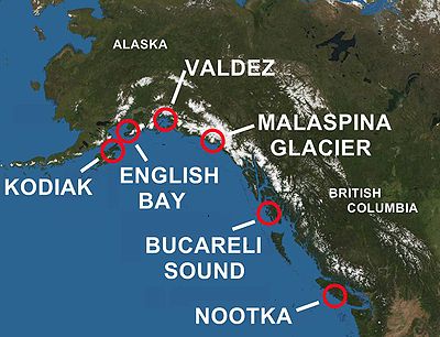
In 1790, Spanish explorer Salvador Fidalgo
Salvador Fidalgo
Salvador Fidalgo y Lopegarcía was a Spanish explorer who commanded an exploring expedition for Spain to Alaska and the Pacific Northwest during the late 18th century.-Early career:...
led an expedition that included visits to the sites of today's Cordova, Alaska and Valdez, Alaska, where acts of sovereignty were performed. Fidalgo went as far as today's Kodiak Island
Kodiak Island
Kodiak Island is a large island on the south coast of the U.S. state of Alaska, separated from the Alaska mainland by the Shelikof Strait. The largest island in the Kodiak Archipelago, Kodiak Island is the second largest island in the United States and the 80th largest island in the world, with an...
, visiting the small Russian settlement there. Fidalgo then went to the Russian settlement at Alexandrovsk (today's English Bay or Nanwalek, Alaska
Nanwalek, Alaska
Nanwalek , formerly English Bay, is census-designated place in the Kenai Peninsula Borough, Alaska, United States that contains a traditional Alutiiq village. The population was 177 at the 2000 census...
), southwest of today's Anchorage
Anchorage, Alaska
Anchorage is a unified home rule municipality in the southcentral part of the U.S. state of Alaska. It is the northernmost major city in the United States...
on the Kenai Peninsula
Kenai Peninsula
The Kenai Peninsula is a large peninsula jutting from the southern coast of Alaska in the United States. The name Kenai is probably derived from Kenayskaya, the Russian name for Cook Inlet, which borders the peninsula to the west.-Geography:...
, where again, Fidalgo re-asserted the Spanish claim to the area by conducting a formal ceremony of sovereignty.
Malaspina Expedition
The Malaspina Expedition was a scientific exploration that took place during a five-year voyage around the globe, commanded by Alessandro Malaspina and José de Bustamante y Guerra. Although the expedition receives its name from Malaspina, he always insisted on giving Bustamante an equal share of...
undertook a search for the Northwest Passage
Northwest Passage
The Northwest Passage is a sea route through the Arctic Ocean, along the northern coast of North America via waterways amidst the Canadian Arctic Archipelago, connecting the Atlantic and Pacific Oceans...
, surveying the Alaska coast from Yakutat Bay
Yakutat Bay
Yakutat Bay is a 29-km-wide bay in the U.S. state of Alaska, extending southwest from Disenchantment Bay to the Gulf of Alaska. "Yakutat" is a Tlingit name reported as "Jacootat" and "Yacootat" by Yuri Lisianski in 1805....
to Prince William Sound
Prince William Sound
Prince William Sound is a sound off the Gulf of Alaska on the south coast of the U.S. state of Alaska. It is located on the east side of the Kenai Peninsula. Its largest port is Valdez, at the southern terminus of the Trans-Alaska Pipeline System...
. At Yakutat Bay, the expedition made contact with the Tlingit. The expedition's scientists made a study of the tribe, recording information on social mores, language, economy, warfare methods, and burial practices. Artists with the expedition, Tomas de Suria
Tomás de Suria
Tomás de Suría was a Spanish artist and explorer. He accompanied Alessandro Malaspina during his expedition to the Pacific States of the United States from 1789 to 1795.-Early life:...
and José Cardero
José Cardero
José Cardero was a Spanish draughtsman and artist. He was born in 1766 in Écija, Spain. He is most remembered for his work on the expedition of Alessandro Malaspina and the related expedition of Dionisio Alcalá Galiano. During the Galiano voyage Cordero Channel was named in his honor...
, produced portraits of tribal members and scenes of Tlingit daily life. A glacier between Yakutat Bay and Icy Bay was subsequently named after Malaspina. The botanist Luis Née
Luis Née
Luis Née was a Franco-Spanish botanist, who accompanied the Malaspina expedition to the Pacific Ocean coasts of North America and Australia.He described many new plants, including the Coast Live Oak, which he discovered in California....
also accompanied the expedition, during which he collected and described numerous new plants.
During the return to Mexico, Malaspina's expedition spent a month at the Spanish outpost in Nootka Sound
Nootka Sound
Nootka Sound is a complex inlet or sound of the Pacific Ocean on the rugged west coast of Vancouver Island, in the Canadian province of British Columbia. Historically also known as King George's Sound, as a strait it separates Vancouver Island and Nootka Island.-History:The inlet is part of the...
on Vancouver Island
Vancouver Island
Vancouver Island is a large island in British Columbia, Canada. It is one of several North American locations named after George Vancouver, the British Royal Navy officer who explored the Pacific Northwest coast of North America between 1791 and 1794...
(see below). The expedition made a study of the Nootka
Nootka
Nootka may refer to:* The Nuu-chah-nulth indigenous peoples and their Nuu-chah-nulth language* The place called Nootka Sound* The island known as Nootka Island* The three treaties signed in the 1790s, known as the Nootka Conventions...
. The two ships then sailed south to Mexico, stopping at the Spanish settlement and mission at Monterey, California on the way. Simultaneously an expedition under Francisco de Eliza
Francisco de Eliza
Francisco de Eliza y Reventa was a Spanish naval officer, navigator, and explorer. He is remembered mainly for his work in the Pacific Northwest...
, exploring the Strait of Juan de Fuca
Strait of Juan de Fuca
The Strait of Juan de Fuca is a large body of water about long that is the Salish Sea outlet to the Pacific Ocean...
, discovered an entrance to the Strait of Georgia
Strait of Georgia
The Strait of Georgia or the Georgia Strait is a strait between Vancouver Island and the mainland coast of British Columbia, Canada. It is approximately long and varies in width from...
, which prompted further investigation. In Acapulco
Acapulco
Acapulco is a city, municipality and major sea port in the state of Guerrero on the Pacific coast of Mexico, southwest from Mexico City. Acapulco is located on a deep, semi-circular bay and has been a port since the early colonial period of Mexico’s history...
, Malaspina took over two schooners, the Sutil
Sutil (ship)
The Sutil was a brig-rigged schooner built in 1791 by the Spanish Navy at San Blas, New Spain. It was nearly identical to the Mexicana, also built at San Blas in 1791...
and Mexicana
Mexicana (ship)
The Mexicana was a topsail schooner built in 1791 by the Spanish Navy at San Blas, New Spain. It was nearly identical to the Sutil, also built at San Blas later in 1791...
, placed them under the command of one of his officers, Dionisio Alcalá Galiano
Dionisio Alcalá Galiano
Dionisio Alcalá Galiano was a Spanish naval officer, cartographer, and explorer. He mapped various coastlines in Europe and the Americas with unprecedented accuracy, using new technology such as chronometers...
, and had them sail north to explore the Strait of Georgia. Galiano's expedition took place in 1792 at the same time as that of George Vancouver
George Vancouver
Captain George Vancouver RN was an English officer of the British Royal Navy, best known for his 1791-95 expedition, which explored and charted North America's northwestern Pacific Coast regions, including the coasts of contemporary Alaska, British Columbia, Washington and Oregon...
. The two expeditions met in the Strait of Georgia and worked together to map the waters and establish the insularity of Vancouver Island.
Today, Spain's legacy endures as dozens of Spanish place names. In Alaska these include the Malaspina Glacier
Malaspina Glacier
The Malaspina Glacier in southeastern Alaska is the largest piedmont glacier the world. Situated at the head of the Alaska Panhandle, it is about wide and long, with an area of some . It is named in honor of Alessandro Malaspina, an Italian explorer in the service of the Spanish Navy, who visited...
and Cordova Glacier, the towns of Valdez
Valdez, Alaska
Valdez is a city in Valdez-Cordova Census Area in the U.S. state of Alaska. According to 2005 Census Bureau estimates, the population of the city is 4,020. The city is one of the most important ports in Alaska. The port of Valdez was named in 1790 after the Spanish naval officer Antonio Valdés y...
, Cordova
Cordova, Alaska
As of the census of 2000, there were 2,454 people, 958 households, and 597 families residing in the city. The population density was 40.0 per square mile . There are 1,099 housing units at an average density of 17.9 per square mile...
and Port Gravina, as well as Orca Bay
Orca Bay, Alaska
Orca Bay is a bay in Prince William Sound, Alaska.Orca Bay is on the north west and west sides of Hawkins Island, extending westward to Johnstone Point of Hinchenbrook Island. Its northwestern corner is demarcated by Knowles Head, between Port Gravina and Fidalgo Bay on the mainland. Its eastern...
, Cordova Peak, and Revillagigedo Island
Revillagigedo Island
Revillagigedo Island is an island in the Alexander Archipelago in Ketchikan Gateway Borough of the southeastern region of the U.S. state of Alaska. Running about 89 km north-south and 48 km east-west, it is 2,754.835 km² in area, making it the 12th largest island in the United...
. In British Columbia some of the better-known Spanish names (of many) include Quadra Island
Quadra Island
Quadra Island is an island off the eastern coast of Vancouver Island, British Columbia, Canada, part of the Discovery Islands. It is separated from Vancouver Island by Discovery Passage, and from Cortes Island by Sutil Channel...
, Galiano Island
Galiano Island
Galiano Island is one of the Southern Gulf Islands between Vancouver Island and the Lower Mainland of British Columbia, Canada. Located on the west side of the Strait of Georgia, it is 27.5 km long, 6 km at its widest point, and 1.6 km across at its narrowest point and is separated...
, Gabriola Island
Gabriola Island
Gabriola Island is one of the Gulf Islands in the Strait of Georgia, in British Columbia , Canada. Gabriola lies about east of Nanaimo on Vancouver Island, to which it is linked by ferry...
and Haro Strait
Haro Strait
Haro Strait, often referred to as the Haro Straits because it is really a series of straits, is one of the main channels connecting the Strait of Georgia to the Strait of Juan de Fuca, separating Vancouver Island and the Gulf Islands in British Columbia, Canada from the San Juan Islands of...
.
British North America
In 1778, the British seafaring Captain James CookJames Cook
Captain James Cook, FRS, RN was a British explorer, navigator and cartographer who ultimately rose to the rank of captain in the Royal Navy...
, midway through his third and final voyage of exploration, sailed along the west coast of North America, mapping the coast from California all the way to the Bering Strait. The northern stretch of the west coast of North America was claimed by the British
Great Britain
Great Britain or Britain is an island situated to the northwest of Continental Europe. It is the ninth largest island in the world, and the largest European island, as well as the largest of the British Isles...
, but the region was not occupied by any British subject until 1788, when John Meares
John Meares
John Meares was a navigator, explorer, and maritime fur trader, best known for his role in the Nootka Crisis, which brought Britain and Spain to the brink of war.- Career :...
first small trading post in Nootka Sound
Nootka Sound
Nootka Sound is a complex inlet or sound of the Pacific Ocean on the rugged west coast of Vancouver Island, in the Canadian province of British Columbia. Historically also known as King George's Sound, as a strait it separates Vancouver Island and Nootka Island.-History:The inlet is part of the...
in today's British Columbia. His post was torn down at the end of 1788 although he claimed otherwise.
Conflict between Spain and Great Britain
Spain established its own competing fortified trading post at Nootka SoundNootka Sound
Nootka Sound is a complex inlet or sound of the Pacific Ocean on the rugged west coast of Vancouver Island, in the Canadian province of British Columbia. Historically also known as King George's Sound, as a strait it separates Vancouver Island and Nootka Island.-History:The inlet is part of the...
(Santa Cruz de Nutka, maintained between 1789 and 1795) on Vancouver Island
Vancouver Island
Vancouver Island is a large island in British Columbia, Canada. It is one of several North American locations named after George Vancouver, the British Royal Navy officer who explored the Pacific Northwest coast of North America between 1791 and 1794...
, in today's British Columbia, and sought forcibly to remove British traders by seizing ships, triggering the Nootka Crisis
Nootka Crisis
The Nootka Crisis was an international incident and political dispute between the Kingdom of Great Britain and the Kingdom of Spain, triggered by a series of events that took place during the summer of 1789 at Nootka Sound...
.
War between Spain and Great Britain over control of the Pacific Northwest was averted by the three Nootka Convention
Nootka Convention
The Nootka Conventions were a series of three agreements between the Kingdom of Spain and the Kingdom of Great Britain, signed in the 1790s which averted a war between the two empires over overlapping claims to portions of the Pacific Northwest coast of North America.The claims of Spain dated back...
s, signed in 1790, 1793, and 1794. Spain gave up its claim that it alone could establish settlements in the Pacific Northwest (a claim that dated back to the 1493 papal bull and Balboa's actions in 1513), and conceded the British right to establish settlements in any area nominally claimed by Spain but never occupied. This agreement effectively allowed a greatly expanded British presence in the Pacific Northwest
Pacific Northwest
The Pacific Northwest is a region in northwestern North America, bounded by the Pacific Ocean to the west and, loosely, by the Rocky Mountains on the east. Definitions of the region vary and there is no commonly agreed upon boundary, even among Pacific Northwesterners. A common concept of the...
, including today's British Columbia, Oregon, and Washington.
The primary beneficiary of this agreement was the Hudson's Bay Company
Hudson's Bay Company
The Hudson's Bay Company , abbreviated HBC, or "The Bay" is the oldest commercial corporation in North America and one of the oldest in the world. A fur trading business for much of its existence, today Hudson's Bay Company owns and operates retail stores throughout Canada...
, which, in 1825, established a major trading post at Fort Vancouver
Fort Vancouver
Fort Vancouver was a 19th century fur trading outpost along the Columbia River that served as the headquarters of the Hudson's Bay Company in the company's Columbia District...
across the Columbia River just north of today's Portland, Oregon
Portland, Oregon
Portland is a city located in the Pacific Northwest, near the confluence of the Willamette and Columbia rivers in the U.S. state of Oregon. As of the 2010 Census, it had a population of 583,776, making it the 29th most populous city in the United States...
. From this headquarters, British-employed fur trappers spread throughout the Pacific Northwest, extending as far east as the Rocky Mountains
Rocky Mountains
The Rocky Mountains are a major mountain range in western North America. The Rocky Mountains stretch more than from the northernmost part of British Columbia, in western Canada, to New Mexico, in the southwestern United States...
and, by using the Siskiyou Trail
Siskiyou Trail
The Siskiyou Trail stretched from California's Central Valley to Oregon's Willamette Valley; modern-day Interstate 5 follows this pioneer path...
, as far south as California's Central Valley
California Central Valley
California's Central Valley is a large, flat valley that dominates the central portion of California. It is home to California's most productive agricultural efforts. The valley stretches approximately from northwest to southeast inland and parallel to the Pacific Ocean coast. Its northern half is...
.
Mexican independence
After the Spanish possession now known as Mexico (first known as "América Septentrional"Solemn Act of the Declaration of Independence of Northern America
The Solemn Act of Northern America's Declaration of Independence is the first Mexican legal historical document which established the separation of Mexico from Spanish rule...
or "Northern America") won its War of Independence
Mexican War of Independence
The Mexican War of Independence was an armed conflict between the people of Mexico and the Spanish colonial authorities which started on 16 September 1810. The movement, which became known as the Mexican War of Independence, was led by Mexican-born Spaniards, Mestizos and Amerindians who sought...
from Spain in 1821, Mexico initially retained Spain's missions and settlements along the Pacific coast, and continued Spain's claims to territory as far north as today's border between California and Oregon. In the 1830s, Mexico ended Church control of the missions in California and opened the land to secular development, particularly ranching. By the 1840s, there were small Mexican settlements at San Diego, Los Angeles
Los Ángeles
Los Ángeles is the capital of the province of Biobío, in the commune of the same name, in Region VIII , in the center-south of Chile. It is located between the Laja and Biobío rivers. The population is 123,445 inhabitants...
, San Francisco, and the territorial capital at Monterey
Monterey, California
The City of Monterey in Monterey County is located on Monterey Bay along the Pacific coast in Central California. Monterey lies at an elevation of 26 feet above sea level. As of the 2010 census, the city population was 27,810. Monterey is of historical importance because it was the capital of...
. These settlements primarily traded cattle hides and tallow
Tallow
Tallow is a rendered form of beef or mutton fat, processed from suet. It is solid at room temperature. Unlike suet, tallow can be stored for extended periods without the need for refrigeration to prevent decomposition, provided it is kept in an airtight container to prevent oxidation.In industry,...
with American and European merchant vessels. This period is vividly portrayed in Bostonian Richard Henry Dana, Jr.
Richard Henry Dana, Jr.
Richard Henry Dana Jr. was an American lawyer and politician from Massachusetts, a descendant of an eminent colonial family who gained renown as the author of the American classic, the memoir Two Years Before the Mast...
's famous seafaring memoir, Two Years Before the Mast
Two Years Before the Mast
Two Years Before the Mast is a book by the American author Richard Henry Dana, Jr., published in 1840, having been written after a two-year sea voyage starting in 1834. A film adaptation under the same name was released in 1946.- Background :...
and the culture of the great Mexican landowners of this period is often harked back to as exemplifying the height of California's romantic pastoral era. Mexican control of the territory ended after only 25 years, when attempts by local Mexican officials to expropriate the property of American ranchers and drive them out of California in the winter lead to the successful uprising known as the bear flag revolt.
Central American independence
During the 1820s, the Central American possessions of Spain gained their independence, and the boundaries of the young nations shifted in alliances and configurations. For example, what was to became the nation of Panama was simply a province of ColombiaColombia
Colombia, officially the Republic of Colombia , is a unitary constitutional republic comprising thirty-two departments. The country is located in northwestern South America, bordered to the east by Venezuela and Brazil; to the south by Ecuador and Peru; to the north by the Caribbean Sea; to the...
, and Guatemala
Guatemala
Guatemala is a country in Central America bordered by Mexico to the north and west, the Pacific Ocean to the southwest, Belize to the northeast, the Caribbean to the east, and Honduras and El Salvador to the southeast...
was variously part of a confederation with Mexico, and part of the United Provinces of Central America, before becoming a separate nation in 1838. Almost all of these Central American nations saw continuing political strife throughout this period (and into the 20th century), as struggles continued between indigenous peoples and elites, and among factions of the elites.
French interest
In 1786, Jean-François de Galaup, comte de La PérouseJean-François de Galaup, comte de La Pérouse
Jean François de Galaup, comte de Lapérouse was a French Navy officer and explorer whose expedition vanished in Oceania.-Early career:...
led a group of French scientists and artists on a voyage of exploration ordered by Louis XVI
Louis XVI of France
Louis XVI was a Bourbon monarch who ruled as King of France and Navarre until 1791, and then as King of the French from 1791 to 1792, before being executed in 1793....
and were welcomed in Monterey, California
Monterey, California
The City of Monterey in Monterey County is located on Monterey Bay along the Pacific coast in Central California. Monterey lies at an elevation of 26 feet above sea level. As of the 2010 census, the city population was 27,810. Monterey is of historical importance because it was the capital of...
. They compiled an account of the California mission system, the land and the people.
The leader of a further French scientific expedition to California, Eugène Duflot de Mofras, wrote in 1840 "…it is evident that California will belong to whatever nation chooses to send there a man-of-war and two hundred men." In 1841, the Mexican military commander in Northern California, General Mariano Vallejo, wrote "there is no doubt that France is intriguing to become mistress of California."
U.S. expansion
In 1805, the first official party of Americans to arrive on the west coast of North America, the fabled expedition of Lewis and Clark, came down the Columbia RiverColumbia River
The Columbia River is the largest river in the Pacific Northwest region of North America. The river rises in the Rocky Mountains of British Columbia, Canada, flows northwest and then south into the U.S. state of Washington, then turns west to form most of the border between Washington and the state...
to the river's mouth on the border between today's Oregon
Oregon
Oregon is a state in the Pacific Northwest region of the United States. It is located on the Pacific coast, with Washington to the north, California to the south, Nevada on the southeast and Idaho to the east. The Columbia and Snake rivers delineate much of Oregon's northern and eastern...
and Washington. In 1819, the United States acquired the Spanish claims to the Pacific Northwest (as negotiated in the Nootka Convention) in the Adams-Onís Treaty
Adams-Onís Treaty
The Adams–Onís Treaty of 1819, also known as the Transcontinental Treaty or the Purchase of Florida, was a treaty between the United States and Spain in 1819 that gave Florida to the U.S. and set out a boundary between the U.S. and New Spain . It settled a standing border dispute between the two...
. The United States argued that it acquired the Spanish rights to exclusive ownership of the Pacific Northwest as far north as Alaska, even though Spain had in fact relinquished any claim to exclusive rights as a result of the Nootka Convention
Nootka Convention
The Nootka Conventions were a series of three agreements between the Kingdom of Spain and the Kingdom of Great Britain, signed in the 1790s which averted a war between the two empires over overlapping claims to portions of the Pacific Northwest coast of North America.The claims of Spain dated back...
s. This position led to a dispute with Britain known as the Oregon boundary dispute
Oregon boundary dispute
The Oregon boundary dispute, or the Oregon Question, arose as a result of competing British and American claims to the Pacific Northwest of North America in the first half of the 19th century. Both the United Kingdom and the United States had territorial and commercial aspirations in the region...
, remembered for the slogan "54-40
54-40
54•40 is a Canadian alternative rock group from Tsawwassen, British Columbia.The band takes their name from the slogan "Fifty-Four Forty or Fight!", coined to express the expansionist agenda of James K...
or fight!" The two countries agreed to defer resolution of the dispute, and to allow settlement by both British and American immigrants in what became known in the United States as the Oregon Country
Oregon Country
The Oregon Country was a predominantly American term referring to a disputed ownership region of the Pacific Northwest of North America. The region was occupied by British and French Canadian fur traders from before 1810, and American settlers from the mid-1830s, with its coastal areas north from...
(today's Oregon, Washington, and Idaho
Idaho
Idaho is a state in the Rocky Mountain area of the United States. The state's largest city and capital is Boise. Residents are called "Idahoans". Idaho was admitted to the Union on July 3, 1890, as the 43rd state....
; much of today's British Columbia; and parts of Montana
Montana
Montana is a state in the Western United States. The western third of Montana contains numerous mountain ranges. Smaller, "island ranges" are found in the central third of the state, for a total of 77 named ranges of the Rocky Mountains. This geographical fact is reflected in the state's name,...
and Wyoming
Wyoming
Wyoming is a state in the mountain region of the Western United States. The western two thirds of the state is covered mostly with the mountain ranges and rangelands in the foothills of the Eastern Rocky Mountains, while the eastern third of the state is high elevation prairie known as the High...
).
In 1841, the United States Exploring Expedition
United States Exploring Expedition
The United States Exploring Expedition was an exploring and surveying expedition of the Pacific Ocean and surrounding lands conducted by the United States from 1838 to 1842. The original appointed commanding officer was Commodore Thomas ap Catesby Jones. The voyage was authorized by Congress in...
visited the west coast of North America by ship, and sent an overland party down the Siskiyou Trail
Siskiyou Trail
The Siskiyou Trail stretched from California's Central Valley to Oregon's Willamette Valley; modern-day Interstate 5 follows this pioneer path...
, from the site of today's Portland, Oregon, to San Francisco.
Americans continued arriving on the west coast of North America in significant numbers in the mid-1830s. They first came overland along the Oregon Trail
Oregon Trail
The Oregon Trail is a historic east-west wagon route that connected the Missouri River to valleys in Oregon and locations in between.After 1840 steam-powered riverboats and steamboats traversing up and down the Ohio, Mississippi and Missouri rivers sped settlement and development in the flat...
, settling primarily in the rich Willamette Valley
Willamette Valley
The Willamette Valley is the most populated region in the state of Oregon of the United States. Located in the state's northwest, the region is surrounded by tall mountain ranges to the east, west and south and the valley's floor is broad, flat and fertile because of Ice Age conditions...
south of today's Portland. By 1841, the first overland party of American settlers reached California along what became the California Trail
California Trail
The California Trail was an emigrant trail of about across the western half of the North American continent from Missouri River towns to what is now the state of California...
, and by the mid-1840s significant numbers of Americans were arriving in California.
In addition, the long-standing dispute between the United States and Great Britain over the Oregon Country was resolved in 1846, with the signing of the Oregon Treaty
Oregon Treaty
The Oregon Treaty is a treaty between the United Kingdom and the United States that was signed on June 15, 1846, in Washington, D.C. The treaty brought an end to the Oregon boundary dispute by settling competing American and British claims to the Oregon Country, which had been jointly occupied by...
; the Oregon Treaty divided the disputed territory along what later became the current international boundary between Canada and the United States.
Rapid growth (1846–1945)
In this era, much of the west coast of North America transformed from an area still largely populated by indigenous peoples to widespread population of non-natives. In particular, the west coast of the United States showed the most dramatic change, beginning with the California Gold RushCalifornia Gold Rush
The California Gold Rush began on January 24, 1848, when gold was found by James W. Marshall at Sutter's Mill in Coloma, California. The first to hear confirmed information of the gold rush were the people in Oregon, the Sandwich Islands , and Latin America, who were the first to start flocking to...
and the subsequent opening of the transcontinental railroads, through the development of Hollywood in Southern California
Southern California
Southern California is a megaregion, or megapolitan area, in the southern area of the U.S. state of California. Large urban areas include Greater Los Angeles and Greater San Diego. The urban area stretches along the coast from Ventura through the Southland and Inland Empire to San Diego...
, and increased industry and agriculture in the U.S. Pacific Northwest. Canadian and Mexican development also proceeded during this time, but at a slower pace.
United States
Americans in California rebelled against Mexico, and in 1846 established the short-lived California RepublicCalifornia Republic
The California Republic, also called the Bear Flag Republic, is the name used for a period of revolt against Mexico initially proclaimed by a handful of American settlers in Mexican California on June 14, 1846, in Sonoma. This was shortly before news of the Mexican–American War had reached the area...
. However, the Mexican-American War had already been declared, and the American military quickly took control of California. At the end of the war
Treaty of Guadalupe Hidalgo
The Treaty of Guadalupe Hidalgo is the peace treaty, largely dictated by the United States to the interim government of a militarily occupied Mexico City, that ended the Mexican-American War on February 2, 1848...
, Mexico ceded control of California to the United States. Things began to change dramatically in 1848 with the California Gold Rush
California Gold Rush
The California Gold Rush began on January 24, 1848, when gold was found by James W. Marshall at Sutter's Mill in Coloma, California. The first to hear confirmed information of the gold rush were the people in Oregon, the Sandwich Islands , and Latin America, who were the first to start flocking to...
which brought an influx of immigrants from around the world. While few found much gold, many stayed, founding communities and turning to farming and other practices. Despite these increases in population the west coast was still on the periphery. The American Civil War
American Civil War
The American Civil War was a civil war fought in the United States of America. In response to the election of Abraham Lincoln as President of the United States, 11 southern slave states declared their secession from the United States and formed the Confederate States of America ; the other 25...
had little effect. This began to change as the first transcontinental railroad
Transcontinental railroad
A transcontinental railroad is a contiguous network of railroad trackage that crosses a continental land mass with terminals at different oceans or continental borders. Such networks can be via the tracks of either a single railroad, or over those owned or controlled by multiple railway companies...
s (completed in 1869) stretched across the United States. For the first time, it was relatively cheap and easy to move to the west coast.
In 1867, the United States acquired Alaska from the Russian Empire, capping American westward expansion on the North American continent.
The next 75 years saw monumental change on the west coast of the United States. Successive booms of agriculture, oil, entertainment, and industry greatly increased California's population. Logging, fishing, and industry drove the economies of California north of the San Francisco Bay Area
San Francisco Bay Area
The San Francisco Bay Area, commonly known as the Bay Area, is a populated region that surrounds the San Francisco and San Pablo estuaries in Northern California. The region encompasses metropolitan areas of San Francisco, Oakland, and San Jose, along with smaller urban and rural areas...
, and Oregon and Washington.
Canada
The gold rush fever spread progressively north; in 1858, the Fraser Canyon Gold RushFraser Canyon Gold Rush
The Fraser Canyon Gold Rush, began in 1858 after gold was discovered on the Thompson River in British Columbia at its confluence with the Nicoamen River. This was a few miles upstream from the Thompson's confluence with the Fraser River at present-day Lytton...
began in British Columbia, and at the end of the century, the Klondike Gold Rush
Klondike Gold Rush
The Klondike Gold Rush, also called the Yukon Gold Rush, the Alaska Gold Rush and the Last Great Gold Rush, was an attempt by an estimated 100,000 people to travel to the Klondike region the Yukon in north-western Canada between 1897 and 1899 in the hope of successfully prospecting for gold...
saw the Yukon
Yukon
Yukon is the westernmost and smallest of Canada's three federal territories. It was named after the Yukon River. The word Yukon means "Great River" in Gwich’in....
hit by masses of prospectors.
The formal delineation of the international border had not completely allayed Britain's fears of losing its Pacific territories, especially as it continued to lag behind the western United States in population and development. As a condition of British Columbia's joining Canadian Confederation
Canadian Confederation
Canadian Confederation was the process by which the federal Dominion of Canada was formed on July 1, 1867. On that day, three British colonies were formed into four Canadian provinces...
in 1871, the Canadian government promised British Columbia a railway, though due to the Pacific Scandal
Pacific Scandal
The Pacific Scandal was a political scandal in Canada involving allegations of bribes being accepted by the Conservative government in the attempts of private interests to influence the bidding for a national rail contract...
and controversies over the location of the Pacific port and railhead and the use of importing Chinese rather than British labour, the Canadian Pacific Railway
Canadian Pacific Railway
The Canadian Pacific Railway , formerly also known as CP Rail between 1968 and 1996, is a historic Canadian Class I railway founded in 1881 and now operated by Canadian Pacific Railway Limited, which began operations as legal owner in a corporate restructuring in 2001...
was not completed until 1885. The new line became an important link in what was known as the All Red Route around the world, linking global travel through territories exclusively British.
Mexico
While the Pacific Coast of Mexico remained relatively undeveloped economically, exceptions were tobacco cultivation in the coastal territory of NayaritNayarit
Nayarit officially Estado Libre y Soberano de Nayarit is one of the 31 states which, with the Federal District, comprise the 32 Federal Entities of Mexico. It is divided in 20 municipalities and its capital city is Tepic.It is located in Western Mexico...
, tourism at Acapulco, and local-scale fishing all along the coast.
Central America
The countries of Central America continued to struggle politically during this time (with perhaps the notable exception of Costa RicaCosta Rica
Costa Rica , officially the Republic of Costa Rica is a multilingual, multiethnic and multicultural country in Central America, bordered by Nicaragua to the north, Panama to the southeast, the Pacific Ocean to the west and the Caribbean Sea to the east....
), and began to expand agriculture, particularly in coffee and bananas with investment and substantial control by the United States. The establishment in 1903 of the newly independent nation of Panama (under pressure from the United States) led to the creation of the Canal Zone
Panama Canal Zone
The Panama Canal Zone was a unorganized U.S. territory located within the Republic of Panama, consisting of the Panama Canal and an area generally extending 5 miles on each side of the centerline, but excluding Panama City and Colón, which otherwise would have been partly within the limits of...
and opening of the Panama Canal
Panama Canal
The Panama Canal is a ship canal in Panama that joins the Atlantic Ocean and the Pacific Ocean and is a key conduit for international maritime trade. Built from 1904 to 1914, the canal has seen annual traffic rise from about 1,000 ships early on to 14,702 vessels measuring a total of 309.6...
in 1914. The opening of the Canal benefited the region economically as trade with the Eastern United States and Europe became far easier.
Immigration
Both the gold rushes and the building of the railroads required vast amounts of labor. One available source that was used on both sides of the border were immigrants from East AsiaEast Asia
East Asia or Eastern Asia is a subregion of Asia that can be defined in either geographical or cultural terms...
, largely from China
China
Chinese civilization may refer to:* China for more general discussion of the country.* Chinese culture* Greater China, the transnational community of ethnic Chinese.* History of China* Sinosphere, the area historically affected by Chinese culture...
and Japan
Japan
Japan is an island nation in East Asia. Located in the Pacific Ocean, it lies to the east of the Sea of Japan, China, North Korea, South Korea and Russia, stretching from the Sea of Okhotsk in the north to the East China Sea and Taiwan in the south...
. These immigrants were willing to work for very little and played a crucial role in building the infrastructure of the west coast. However, they faced constant discrimination. Asians were deprived of their civil rights
Civil rights
Civil and political rights are a class of rights that protect individuals' freedom from unwarranted infringement by governments and private organizations, and ensure one's ability to participate in the civil and political life of the state without discrimination or repression.Civil rights include...
in both the United States and Canada. There was also pressure to restrict Asian immigration, opinions that were acted on with quota
Quota share
A quota share is a specified number or percentage of the allotment as a whole , that is prescribed to each individual entity ....
s, head taxes, and finally a complete ban in both nations in the 1920s. Because of discrimination, and also a desire to remain a community, Chinatown
Chinatown
A Chinatown is an ethnic enclave of overseas Chinese people, although it is often generalized to include various Southeast Asian people. Chinatowns exist throughout the world, including East Asia, Southeast Asia, the Americas, Australasia, and Europe. Binondo's Chinatown located in Manila,...
s developed in all the major cities along the west coast.
Increased trade and World War II
The rise of the Japanese economy also benefited the region as the ability to trade across the Pacific continued to show its great potential.However, only a few decades later, Japan
Empire of Japan
The Empire of Japan is the name of the state of Japan that existed from the Meiji Restoration on 3 January 1868 to the enactment of the post-World War II Constitution of...
would become a major threat. During World War II
World War II
World War II, or the Second World War , was a global conflict lasting from 1939 to 1945, involving most of the world's nations—including all of the great powers—eventually forming two opposing military alliances: the Allies and the Axis...
, there were few attacks against North America, but the occasional Japanese submarine
Submarine
A submarine is a watercraft capable of independent operation below the surface of the water. It differs from a submersible, which has more limited underwater capability...
lurked off the shores. Japan tried to damage the region by sending over hundreds of balloon bombs in an attempt to light forest fires. These were generally ineffective; a few landed in either Canada or the United States but they caused no great destruction. More destructive was the internment
Japanese American internment
Japanese-American internment was the relocation and internment by the United States government in 1942 of approximately 110,000 Japanese Americans and Japanese who lived along the Pacific coast of the United States to camps called "War Relocation Camps," in the wake of Imperial Japan's attack on...
of ethnic Japanese
Ethnic Japanese
Ethnic Japanese may mean:* Japanese people, when referring to people of Japanese descent** May also be used as a term to refer to the Yamato people as opposed to the minority peoples of Japan: the Ainu, Ryukyuans, Burakumin and immigrant groups such as the Han Chinese and Koreans.* Japanese...
, who were expropriated and sent into internal exile merely for their descent.
Post-war period (1945–present)
The post-war years would be ones of great prosperity and growth on the west coast of North America. The quick reemergence of Japan and its stunning growth over the next decades meant great wealth for the west coast ports. Japan became the second largest trading partner of both Canada and the United States, and this trade was almost entirely based in the west coast (the US and Canada are each other's largest trading partners). Later the other Asian economies would add to this trade. Throughout the northwest the primary extractive activities of loggingLogging
Logging is the cutting, skidding, on-site processing, and loading of trees or logs onto trucks.In forestry, the term logging is sometimes used in a narrow sense concerning the logistics of moving wood from the stump to somewhere outside the forest, usually a sawmill or a lumber yard...
, mining
Mining
Mining is the extraction of valuable minerals or other geological materials from the earth, from an ore body, vein or seam. The term also includes the removal of soil. Materials recovered by mining include base metals, precious metals, iron, uranium, coal, diamonds, limestone, oil shale, rock...
, and fishing
Fishing
Fishing is the activity of trying to catch wild fish. Fish are normally caught in the wild. Techniques for catching fish include hand gathering, spearing, netting, angling and trapping....
remained the central industries. California, however, became a cultural centre to rival the northeast due to the film
Film
A film, also called a movie or motion picture, is a series of still or moving images. It is produced by recording photographic images with cameras, or by creating images using animation techniques or visual effects...
industry as well as becoming a centre of music
Music
Music is an art form whose medium is sound and silence. Its common elements are pitch , rhythm , dynamics, and the sonic qualities of timbre and texture...
, literature
Literature
Literature is the art of written works, and is not bound to published sources...
, and cooking
Cooking
Cooking is the process of preparing food by use of heat. Cooking techniques and ingredients vary widely across the world, reflecting unique environmental, economic, and cultural traditions. Cooks themselves also vary widely in skill and training...
. The area became home to some of the continent's greatest universities.
Unlike the east, the western economies were not based upon manufacturing and the great deindustrialization
Deindustrialization
Deindustrialization is a process of social and economic change caused by the removal or reduction of industrial capacity or activity in a country or region, especially heavy industry or manufacturing industry. It is an opposite of industrialization.- Multiple interpretations :There are multiple...
of the 1970s and 1980s did little to hurt the region—creating an imbalance between rapid growth in the west and stagnation or decline in the east.
During this period, the west coast became the bastion of conservatism
Conservatism
Conservatism is a political and social philosophy that promotes the maintenance of traditional institutions and supports, at the most, minimal and gradual change in society. Some conservatives seek to preserve things as they are, emphasizing stability and continuity, while others oppose modernism...
with the population favouring low taxes and small government. In the United States, this manifested itself in support for the Republican Party
Republican Party (United States)
The Republican Party is one of the two major contemporary political parties in the United States, along with the Democratic Party. Founded by anti-slavery expansion activists in 1854, it is often called the GOP . The party's platform generally reflects American conservatism in the U.S...
, especially for the two Republican California-based presidents Richard Nixon
Richard Nixon
Richard Milhous Nixon was the 37th President of the United States, serving from 1969 to 1974. The only president to resign the office, Nixon had previously served as a US representative and senator from California and as the 36th Vice President of the United States from 1953 to 1961 under...
and Ronald Reagan
Ronald Reagan
Ronald Wilson Reagan was the 40th President of the United States , the 33rd Governor of California and, prior to that, a radio, film and television actor....
. In British Columbia, the right wing Social Credit Party
British Columbia Social Credit Party
The British Columbia Social Credit Party, whose members are known as Socreds, was the governing political party of British Columbia, Canada, for more than 30 years between the 1952 provincial election and the 1991 election...
governed for over thirty years. Nonetheless, the great port cities of San Francisco and Vancouver both fostered alternative views, acting as centres for environmentalism, unions, feminism, and gay rights.
The general economic revival of North America in the late 1990s brought the East back to health, but even greater growth in Northern California due to the high-tech industry. The region was hurt, however, by the decade-long economic slump of Japan beginning at the same time. This was made up for by the rapid growth of Southeast Asia, South Korea
South Korea
The Republic of Korea , , is a sovereign state in East Asia, located on the southern portion of the Korean Peninsula. It is neighbored by the People's Republic of China to the west, Japan to the east, North Korea to the north, and the East China Sea and Republic of China to the south...
, and especially China
China
Chinese civilization may refer to:* China for more general discussion of the country.* Chinese culture* Greater China, the transnational community of ethnic Chinese.* History of China* Sinosphere, the area historically affected by Chinese culture...
. The entire region shifted quite dramatically politically, however. Westerners diverged from conservatism over social issues such as gay rights, abortion
Abortion
Abortion is defined as the termination of pregnancy by the removal or expulsion from the uterus of a fetus or embryo prior to viability. An abortion can occur spontaneously, in which case it is usually called a miscarriage, or it can be purposely induced...
, and the legalization of soft drugs. In 1991, British Columbia threw out Social Credit electing the social democratic
Social democracy
Social democracy is a political ideology of the center-left on the political spectrum. Social democracy is officially a form of evolutionary reformist socialism. It supports class collaboration as the course to achieve socialism...
British Columbia New Democratic Party. California, Washington, and Oregon were pivotal in Bill Clinton
Bill Clinton
William Jefferson "Bill" Clinton is an American politician who served as the 42nd President of the United States from 1993 to 2001. Inaugurated at age 46, he was the third-youngest president. He took office at the end of the Cold War, and was the first president of the baby boomer generation...
's two victories and Al Gore
Al Gore
Albert Arnold "Al" Gore, Jr. served as the 45th Vice President of the United States , under President Bill Clinton. He was the Democratic Party's nominee for President in the 2000 U.S. presidential election....
and John Kerry
John Kerry
John Forbes Kerry is the senior United States Senator from Massachusetts, the 10th most senior U.S. Senator and chairman of the Senate Foreign Relations Committee. He was the presidential nominee of the Democratic Party in the 2004 presidential election, but lost to former President George W...
's near wins in 2000 and 2004. This change was mainly in the urban coastal areas. Inland, rural regions of California remained staunchly Republican, and although once full of labour strongholds, the Interior of British Columbia has voted solidly for the Reform Party
Reform Party of Canada
The Reform Party of Canada was a Canadian federal political party that existed from 1987 to 2000. It was originally founded as a Western Canada-based protest party, but attempted to expand eastward in the 1990s. It viewed itself as a populist party....
and its successors.
See also
- Indigenous peoples of the AmericasIndigenous peoples of the AmericasThe indigenous peoples of the Americas are the pre-Columbian inhabitants of North and South America, their descendants and other ethnic groups who are identified with those peoples. Indigenous peoples are known in Canada as Aboriginal peoples, and in the United States as Native Americans...
- Indigenous peoples of CaliforniaIndigenous peoples of CaliforniaThe Indigenous peoples of California are the indigenous inhabitants who have lived or currently live in the geographic area within the current boundaries of California before and after the arrival of Europeans. With over one hundred federally recognized tribes, California has the largest Native...
- Models of migration to the New WorldModels of migration to the New WorldThere have been several models for the human settlement of the Americas proposed by various academic communities. The question of how, when and why humans first entered the Americas is of intense interest to archaeologists and anthropologists, and has been a subject of heated debate for centuries...
- Native Americans in the United StatesNative Americans in the United StatesNative Americans in the United States are the indigenous peoples in North America within the boundaries of the present-day continental United States, parts of Alaska, and the island state of Hawaii. They are composed of numerous, distinct tribes, states, and ethnic groups, many of which survive as...
- Classification of indigenous peoples of the AmericasClassification of indigenous peoples of the AmericasClassification of indigenous peoples of the Americas is based upon cultural regions, geography, and linguistics. Anthropologists have named various cultural regions, with fluid boundaries, that are generally agreed upon with some variation...
- Paleo-Indians
- History of AlaskaHistory of AlaskaThe history of Alaska dates back to the Upper Paleolithic period , when Asiatic groups crossed the Bering land bridge into what is now western Alaska. At the time of European contact by the Russian explorers, the area was populated by Alaska Native groups...
- History of British ColumbiaHistory of British ColumbiaBritish Columbia is the westernmost province in Canada. Originally politically constituted as a pair of British colonies, British Columbia joined the Canadian Confederation on July 20, 1871.-Early history :...
- History of CaliforniaHistory of CaliforniaThe history of California can be divided into several periods: the Native American period; European exploration period from 1542 to 1769; the Spanish colonial period, 1769 to 1821; the Mexican period, 1821 to 1848; and United States statehood, which continues to the present day...
- History of OregonHistory of OregonThe history of Oregon, a U.S. state, may be considered in five eras: geologic history, inhabitation by native peoples, early exploration by Europeans , settlement by pioneers, and modern development....
- History of Washington
- History of MexicoHistory of MexicoThe history of Mexico, a country located in the southern portion of North America, covers a period of more than two millennia. First populated more than 13,000 years ago, the country produced complex indigenous civilizations before being conquered by the Spanish in the 16th Century.Since the...
- History of GuatemalaHistory of GuatemalaThe history of Guatemala begins with the arrival of the first human settlers as early as 12,000 BC or even 18,000 BC. Civilization developed and flourished during the Pre-Columbian era with little to no contact with cultures from outside of Mesoamerica...
- History of El SalvadorHistory of El SalvadorThe history of El Salvador has been a history of struggle against conquistadors, empires, dictatorships and world powers to be free. El Salvador was one of the regions that resisted the Spanish invasion led by Pedro de Alvarado who had to fight Atlantica and retreat several times back to Guatemala...
- History of Costa RicaHistory of Costa Rica-Early history:In Pre-Columbian times the Native Americans in what is now Costa Rica were part of a cultural complex known as the "Intermediate Area," between the Mesoamerican and Andean cultural regions....
- History of PanamaHistory of PanamaThe History of Panama is about the Isthmus of Panama region's long history that occurred in southern Central America, from Pre-Columbian cultures, during the Spanish colonial era, through independence and the current country of Panama.-Indigenous period:...
- Origin of the name CaliforniaOrigin of the name CaliforniaCalifornia is a place name used by three North American states: in the United States by the state of California, and in Mexico by the states of Baja California and Baja California Sur. Collectively, these three areas constitute the region formerly referred to as Las Californias...
- Spanish expeditions to the Pacific Northwest
- YukonYukonYukon is the westernmost and smallest of Canada's three federal territories. It was named after the Yukon River. The word Yukon means "Great River" in Gwich’in....
- 1934 West Coast Longshore Strike1934 West Coast Longshore StrikeThe 1934 West Coast Waterfront Strike lasted eighty-three days, triggered by sailors and a four-day general strike in San Francisco, and led to the unionization of all of the West Coast ports of the United States...
- Fort StikineFort StikineFort Stikine was a fur trade post and fortification in what is now the Alaska Panhandle, at the site of the present-day of Wrangell, Alaska, United States...