
Gabriola Island
Encyclopedia
Gabriola Island is one of the Gulf Islands
in the Strait of Georgia
, in British Columbia
(BC), Canada
. Gabriola lies about 5 kilometres (3.1 mi) east of Nanaimo on Vancouver Island
, to which it is linked by ferry. It has a land area of about 57.6 square kilometres (22.2 sq mi) and a resident population of slightly more than 4,000.
Gabriola has a mild climate, public beaches, and forested parks, as well as housing, roads, shopping centres, restaurants, a library, a school, and a museum. Its cultural life includes annual festivals related to art, poetry, gardens, music, boating, and fishing.
, and the name of the nearby city, Nanaimo, is an anglicized form of their name. The earliest archeological record on Gabriola is a cave burial dated to about 1500 BCE
, but sites on nearby Valdes Island
and other Gulf Islands
have been found to date to at least 3000 BCE, and similar sites might exist on Gabriola.
The pre-contact population of Gabriola has been difficult to estimate, but in mid-Marpole times—between about 0 and 1000 CE
—several thousand people lived in the village at False Narrows, the site of today's El Verano Drive. Archaeologists have found that infant mortality at that time was surprisingly low and that the population was well adapted to its environment. Other smaller villages on Gabriola were scattered around the coast. After contact, and perhaps as early as 1500 CE, the population of the Snunéymux declined drastically because of smallpox and other diseases brought to North America by Europeans.
The island is famous for its petroglyph
s, which are commonly asserted to be thousands of years old. The reality is that they are almost impossible to date. Because they are carved in relatively soft sandstone, they are eroding rapidly.
in 1791. Narváez is said to have given the name Punta de Gaviola to the southeastern end of the island and that over time Gaviola was corrupted into Gabriola and applied to the whole island. It may have been Juan Francisco de la Bodega y Quadra
, rather than Narváez who gave the name. Gaviola is sometimes said to be a misspelling of gaviota ("seagull"), but it may refer to the Spanish surname Gaviola. In 1792 the island was again visited by a Spanish expedition, under Galiano
and Valdés
. Galiano and Valdés stayed at Descanso Bay for several days, repairing their ships and boats and exploring the vicinity of Nanaimo. The name Descanso was given by them, because they wanted to give their sailors some rest. The British expedition of George Vancouver
also visited the island in 1792. While the Spanish explored and charted the Strait of Georgia, they left no permanent settlements. In 1827, fur traders of the Hudson's Bay Company
established a post at Fort Langley
on the Fraser River
, but no Europeans settled in the Nanaimo area until the discovery of coal there in 1852. From the mid-1850s on, coal miners and ex-gold miners began to move to Gabriola, where they started farms to supply the growing population of Nanaimo.
By 1874, 17 settlers were working the land on Gabriola, and two thirds of those had First Nations
wives and young families. The mixed marriages resulted in part from the gender imbalance in the immigrant population but also in part because the wives knew how to survive on the west coast
.
In the early 20th century, the population of Gabriola grew slowly. By the 1950s, fewer than 400 people lived full-time on the island. Electricity came to Gabriola in 1955, but even then the population grew only about one percent a year until the 1970s. In roughly the next 10 years, the population tripled, in part due to hippie
immigration from the United States. By the mid-1980s, the population was 2,000, half the current figure.
In summer, the island's population greatly increases. Even in the first half of the 20th century, families came from Nanaimo or Vancouver
to spend weeks or months living a simpler, rural life on the island. In the 21st century, about come to Gabriola each year for the sun, music, art, and relaxed pace, and they raise the population temporarily to about 6,000.
Apart from farming, Gabriola experienced industrial development in the 20th century. A brickyard produced a day in the early part of the century, and they were sent principally to Victoria
and Vancouver. The brickyard ceased functioning in the 1950s. In the 1890s and early twentieth century sandstone blocks were cut from a quarry near Descanso Bay and shipped for architectural use in public buildings in Vancouver and Victoria. In the early-to-mid-1930s, millstone
s were cut from the sandstone and sent to towns along the west coast and as far away as Finland for use in the pulp and paper industry. A small diatomaceous earth
industry also flourished in the 1930s. The product was sent mainly to China to be used as women's face powder, but World War II
made this trade impossible, and the industry closed down. After World War II, the shipyard at Silva Bay became the major employer on the island until the 1970s.
in the Strait of Georgia between mainland BC to the east and Vancouver Island
to the west. The Gulf Islands are an archipelago consisting of hundreds of islands of various sizes stretching from the San Juan Islands
in the United States to the Northern Gulf Islands, north of Gabriola. The biggest of the Southern Gulf Islands are Gabriola Island, Galiano Island
, Kuper Island
, North and South Pender Island
, Saltspring Island
, Saturna Island
, Thetis Island
, and Valdes Island
.
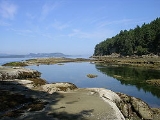
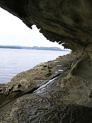
The Southern Gulf Islands consist mainly of former seabed sediments crumpled and gradually thrust upward by tectonic plate movement between ago. Subsequent periods of glaciation scraped away topsoil and some of the bedrock. During the peak of the Fraser Glaciation, ago, Gabriola was covered with ice up to 2 kilometres (1.2 mi) thick. Though melting glaciers left deposits of sand, gravel, and boulders, the main rocks exposed on Gabriola's surface are sandstone and shale. Differential erosion of relatively soft shales and relatively hard sandstones helped create cliffs, points, and bays along Gabriola's shoreline.
Gabriola is about 14 kilometres (9 mi) long by 4.2 kilometres (2.6 mi) wide on average with a land area of 57.6 square kilometres (22.2 sq mi). The topography varies from flat sandy beaches at sea level to forested hills rising to 160 metres (525 ft) on Stoney Ridge in the center of the island.
Gabriola lies about 5 kilometres (3.1 mi) east of Nanaimo, the second largest city on Vancouver Island, to which it is linked by BC Ferries
. The ferry, which takes 20 minutes for the crossing, runs almost hourly from about 5.30 a.m. to about 11.30 p.m. daily. Residents of Gabriola who work or attend high school in Nanaimo use the ferry to commute. Gabriola may also be reached by float plane or small boat.
 Islands and islets near Gabriola include Snake Island and Entrance Island to the north, the Flat Top Islands, Breakwater Island, and Valdes Island to the east, and Mudge Island, Link Island, and DeCourcy Island to the south. The North Road-South Road loop of 30 kilometres (18.6 mi) is the main island highway. It passes near most parts of the island, including the ferry terminal at Descanso Bay.
The island has three provincial parks—Gabriola Sands Provincial Park
on the northwest shore, Sandwell Provincial Park
on the northeast shore, and Drumbeg Provincial Park on the east shore—as well as Descanso Bay Regional Park and an adjacent community park near the ferry terminal. Large coastal sandstone formations known as the Malaspina Galleries are preserved in this community park. The formations were named after the 18th-century Spanish explorer Alejandro Malaspina
.
The total number of private dwellings on Gabriola was 2,744 in 2006, of which 1,998 were occupied by the usual residents. The median age of the population was 52.9 years compared to the BC median of 40.8. Of the total population, 1,960 were male and 2,090 were female.
Camp Miriam, a Jewish summer camp, operates on the island from the end of June through the end of August.
 Folklife Village, on North Road a few minutes beyond the ferry terminal, is the island's main shopping centre. It was bought and transferred to Gabriola after its role as the Folklife Pavilion, a tribute to Canada's native and settler cultures, in Expo 86
in Vancouver. Other shopping areas can be found at Twin Beaches Mall on the north end of the island and Silva Bay on the south end. The island has a strong connection to the city of Nanaimo. Gabriola residents often refer to Gabriola as The Rock and to Vancouver Island as The Big Island.
Gabriola and surrounding islands have more than 70 known petroglyph
s - sandstone carvings, some of which may be as old as 2,000 years or more. A small park at the Gabriola Museum contains reproductions of some of these petroglyphs.
, Western redcedar
, arbutus
, Garry oak
, bigleaf maple, and red alder; the shrubs Oregon-grape, and red-flowering currant
; the perennial herb small camas (common camas); the semi-aquatic or terrestrial herb Western skunk cabbage
(swamp lantern), and the evergreen perennial Western sword fern
.
Sea creatures near Gabriola include orca
s (killer whales), sea lions, seals, otters, oysters, mussels, clams, wolf eels, octopuses, and salmon. Deer and raccoons are among the island's more common land animals.
In the winter months, the coast of Gabriola is visited by many species of waterfowl such as the Scoter
, Bufflehead
, Barrow's Goldeneye
, and Harlequin Duck
. Shorebirds such as the Black Turnstone
and Ruddy Turnstone
frequent the island as do garden birds such as the Ruby-crowned Kinglet, Golden-crowned Kinglet
, Thrush
es, Warbler
s, Pileated Woodpecker
s, and Flicker
s. The Bald Eagle
, European Starling
, and Turkey Vulture
are common year round. More than 250 bird species live in or migrate through the Nanaimo–Gabriola area.
Gulf Islands
The Gulf Islands are the islands in the Strait of Georgia , between Vancouver Island and the mainland of British Columbia, Canada....
in the Strait of Georgia
Strait of Georgia
The Strait of Georgia or the Georgia Strait is a strait between Vancouver Island and the mainland coast of British Columbia, Canada. It is approximately long and varies in width from...
, in British Columbia
British Columbia
British Columbia is the westernmost of Canada's provinces and is known for its natural beauty, as reflected in its Latin motto, Splendor sine occasu . Its name was chosen by Queen Victoria in 1858...
(BC), Canada
Canada
Canada is a North American country consisting of ten provinces and three territories. Located in the northern part of the continent, it extends from the Atlantic Ocean in the east to the Pacific Ocean in the west, and northward into the Arctic Ocean...
. Gabriola lies about 5 kilometres (3.1 mi) east of Nanaimo on Vancouver Island
Vancouver Island
Vancouver Island is a large island in British Columbia, Canada. It is one of several North American locations named after George Vancouver, the British Royal Navy officer who explored the Pacific Northwest coast of North America between 1791 and 1794...
, to which it is linked by ferry. It has a land area of about 57.6 square kilometres (22.2 sq mi) and a resident population of slightly more than 4,000.
Gabriola has a mild climate, public beaches, and forested parks, as well as housing, roads, shopping centres, restaurants, a library, a school, and a museum. Its cultural life includes annual festivals related to art, poetry, gardens, music, boating, and fishing.
Pre-contact
Gabriola is part of the traditional territory of the SnunéymuxSnuneymuxw First Nation
The Snuneymuxw First Nation is the band government of the Snuneymuxw of west-central Vancouver Island, British Columbia, Canada. The Snuneymuxw First Nation have lived along the eastern coast of south-central Vancouver Island, British Columbia for an estimated 5,000 years...
, and the name of the nearby city, Nanaimo, is an anglicized form of their name. The earliest archeological record on Gabriola is a cave burial dated to about 1500 BCE
Common Era
Common Era ,abbreviated as CE, is an alternative designation for the calendar era originally introduced by Dionysius Exiguus in the 6th century, traditionally identified with Anno Domini .Dates before the year 1 CE are indicated by the usage of BCE, short for Before the Common Era Common Era...
, but sites on nearby Valdes Island
Valdes Island
Valdes Island is one of the Gulf Islands located in the Strait of Georgia, British Columbia, Canada. It is across Porlier Pass from Galiano Island, which lies to the southeast. It has an area of 23 km2, and is 1.6 km wide by 16 km in length...
and other Gulf Islands
Gulf Islands
The Gulf Islands are the islands in the Strait of Georgia , between Vancouver Island and the mainland of British Columbia, Canada....
have been found to date to at least 3000 BCE, and similar sites might exist on Gabriola.
The pre-contact population of Gabriola has been difficult to estimate, but in mid-Marpole times—between about 0 and 1000 CE
Common Era
Common Era ,abbreviated as CE, is an alternative designation for the calendar era originally introduced by Dionysius Exiguus in the 6th century, traditionally identified with Anno Domini .Dates before the year 1 CE are indicated by the usage of BCE, short for Before the Common Era Common Era...
—several thousand people lived in the village at False Narrows, the site of today's El Verano Drive. Archaeologists have found that infant mortality at that time was surprisingly low and that the population was well adapted to its environment. Other smaller villages on Gabriola were scattered around the coast. After contact, and perhaps as early as 1500 CE, the population of the Snunéymux declined drastically because of smallpox and other diseases brought to North America by Europeans.
The island is famous for its petroglyph
Petroglyph
Petroglyphs are pictogram and logogram images created by removing part of a rock surface by incising, picking, carving, and abrading. Outside North America, scholars often use terms such as "carving", "engraving", or other descriptions of the technique to refer to such images...
s, which are commonly asserted to be thousands of years old. The reality is that they are almost impossible to date. Because they are carved in relatively soft sandstone, they are eroding rapidly.
Post-contact
The first European visit to Gabriola was by the Spanish schooner Santa Saturnina under José María NarváezJosé María Narváez
José María Narváez was a Spanish naval officer, explorer, and navigator notable for his work in the Pacific Northwest of present-day Canada. In 1791, as commander of the schooner Santa Saturnina, he led the first European exploration of the Strait of Georgia, including a landing on present-day...
in 1791. Narváez is said to have given the name Punta de Gaviola to the southeastern end of the island and that over time Gaviola was corrupted into Gabriola and applied to the whole island. It may have been Juan Francisco de la Bodega y Quadra
Juan Francisco de la Bodega y Quadra
Juan Francisco de la Bodega y Quadra was a Spanish naval officer born in Lima, Peru. Assigned to the Pacific coast Spanish Naval Department base at San Blas, in the Viceroyalty of New Spain , this navigator explored the Northwest Coast of North America as far north as present day Alaska.Juan...
, rather than Narváez who gave the name. Gaviola is sometimes said to be a misspelling of gaviota ("seagull"), but it may refer to the Spanish surname Gaviola. In 1792 the island was again visited by a Spanish expedition, under Galiano
Dionisio Alcalá Galiano
Dionisio Alcalá Galiano was a Spanish naval officer, cartographer, and explorer. He mapped various coastlines in Europe and the Americas with unprecedented accuracy, using new technology such as chronometers...
and Valdés
Cayetano Valdés y Flores
Cayetano Valdés y Flores Bazán was a commander of the Spanish Navy, explorer, and captain general who served in the French Revolutionary and Napoleonic Wars, fighting for both sides at different times due to the changing fortunes of Spain in the conflict...
. Galiano and Valdés stayed at Descanso Bay for several days, repairing their ships and boats and exploring the vicinity of Nanaimo. The name Descanso was given by them, because they wanted to give their sailors some rest. The British expedition of George Vancouver
George Vancouver
Captain George Vancouver RN was an English officer of the British Royal Navy, best known for his 1791-95 expedition, which explored and charted North America's northwestern Pacific Coast regions, including the coasts of contemporary Alaska, British Columbia, Washington and Oregon...
also visited the island in 1792. While the Spanish explored and charted the Strait of Georgia, they left no permanent settlements. In 1827, fur traders of the Hudson's Bay Company
Hudson's Bay Company
The Hudson's Bay Company , abbreviated HBC, or "The Bay" is the oldest commercial corporation in North America and one of the oldest in the world. A fur trading business for much of its existence, today Hudson's Bay Company owns and operates retail stores throughout Canada...
established a post at Fort Langley
Fort Langley, British Columbia
Fort Langley is a village with a population of 2,700 and forms part of the Township of Langley. It is the home of Fort Langley National Historic Site, a former fur trade post of the Hudson's Bay Company.-History:...
on the Fraser River
Fraser River
The Fraser River is the longest river within British Columbia, Canada, rising at Fraser Pass near Mount Robson in the Rocky Mountains and flowing for , into the Strait of Georgia at the city of Vancouver. It is the tenth longest river in Canada...
, but no Europeans settled in the Nanaimo area until the discovery of coal there in 1852. From the mid-1850s on, coal miners and ex-gold miners began to move to Gabriola, where they started farms to supply the growing population of Nanaimo.
By 1874, 17 settlers were working the land on Gabriola, and two thirds of those had First Nations
First Nations
First Nations is a term that collectively refers to various Aboriginal peoples in Canada who are neither Inuit nor Métis. There are currently over 630 recognised First Nations governments or bands spread across Canada, roughly half of which are in the provinces of Ontario and British Columbia. The...
wives and young families. The mixed marriages resulted in part from the gender imbalance in the immigrant population but also in part because the wives knew how to survive on the west coast
British Columbia Coast
The British Columbia Coast or BC Coast is Canada's western continental coastline on the Pacific Ocean. The usage is synonymous with the term West Coast of Canada....
.
In the early 20th century, the population of Gabriola grew slowly. By the 1950s, fewer than 400 people lived full-time on the island. Electricity came to Gabriola in 1955, but even then the population grew only about one percent a year until the 1970s. In roughly the next 10 years, the population tripled, in part due to hippie
Hippie
The hippie subculture was originally a youth movement that arose in the United States during the mid-1960s and spread to other countries around the world. The etymology of the term 'hippie' is from hipster, and was initially used to describe beatniks who had moved into San Francisco's...
immigration from the United States. By the mid-1980s, the population was 2,000, half the current figure.
In summer, the island's population greatly increases. Even in the first half of the 20th century, families came from Nanaimo or Vancouver
Vancouver
Vancouver is a coastal seaport city on the mainland of British Columbia, Canada. It is the hub of Greater Vancouver, which, with over 2.3 million residents, is the third most populous metropolitan area in the country,...
to spend weeks or months living a simpler, rural life on the island. In the 21st century, about come to Gabriola each year for the sun, music, art, and relaxed pace, and they raise the population temporarily to about 6,000.
Apart from farming, Gabriola experienced industrial development in the 20th century. A brickyard produced a day in the early part of the century, and they were sent principally to Victoria
Victoria, British Columbia
Victoria is the capital city of British Columbia, Canada and is located on the southern tip of Vancouver Island off Canada's Pacific coast. The city has a population of about 78,000 within the metropolitan area of Greater Victoria, which has a population of 360,063, the 15th most populous Canadian...
and Vancouver. The brickyard ceased functioning in the 1950s. In the 1890s and early twentieth century sandstone blocks were cut from a quarry near Descanso Bay and shipped for architectural use in public buildings in Vancouver and Victoria. In the early-to-mid-1930s, millstone
Millstone
Millstones or mill stones are used in windmills and watermills, including tide mills, for grinding wheat or other grains.The type of stone most suitable for making millstones is a siliceous rock called burrstone , an open-textured, porous but tough, fine-grained sandstone, or a silicified,...
s were cut from the sandstone and sent to towns along the west coast and as far away as Finland for use in the pulp and paper industry. A small diatomaceous earth
Diatomaceous earth
Diatomaceous earth also known as diatomite or kieselgur/kieselguhr, is a naturally occurring, soft, siliceous sedimentary rock that is easily crumbled into a fine white to off-white powder. It has a particle size ranging from less than 1 micrometre to more than 1 millimetre, but typically 10 to...
industry also flourished in the 1930s. The product was sent mainly to China to be used as women's face powder, but World War II
World War II
World War II, or the Second World War , was a global conflict lasting from 1939 to 1945, involving most of the world's nations—including all of the great powers—eventually forming two opposing military alliances: the Allies and the Axis...
made this trade impossible, and the industry closed down. After World War II, the shipyard at Silva Bay became the major employer on the island until the 1970s.
Geography
Gabriola, part of the Regional District of Nanaimo, is the most northerly of the Southern Gulf IslandsGulf Islands
The Gulf Islands are the islands in the Strait of Georgia , between Vancouver Island and the mainland of British Columbia, Canada....
in the Strait of Georgia between mainland BC to the east and Vancouver Island
Vancouver Island
Vancouver Island is a large island in British Columbia, Canada. It is one of several North American locations named after George Vancouver, the British Royal Navy officer who explored the Pacific Northwest coast of North America between 1791 and 1794...
to the west. The Gulf Islands are an archipelago consisting of hundreds of islands of various sizes stretching from the San Juan Islands
San Juan Islands
The San Juan Islands are an archipelago in the northwest corner of the contiguous United States between the US mainland and Vancouver Island, British Columbia, Canada. The San Juan Islands are part of the U.S...
in the United States to the Northern Gulf Islands, north of Gabriola. The biggest of the Southern Gulf Islands are Gabriola Island, Galiano Island
Galiano Island
Galiano Island is one of the Southern Gulf Islands between Vancouver Island and the Lower Mainland of British Columbia, Canada. Located on the west side of the Strait of Georgia, it is 27.5 km long, 6 km at its widest point, and 1.6 km across at its narrowest point and is separated...
, Kuper Island
Kuper Island
Kuper Island belongs to the Penelakut First Nation and is located in the southern Gulf Islands between Vancouver Island and the mainland Pacific coast of British Columbia, Canada. Kuper has a population of about 300 members of the Penelakut Band. The island has an area of 8.66 km²...
, North and South Pender Island
Pender Island
Pender Island is one of the Southern Gulf Islands located in the Gulf of Georgia, British Columbia, Canada. Pender Island is approximately in area and is home to about 2,500 permanent residents, as well as a large seasonal population...
, Saltspring Island
Saltspring Island
Saltspring Island is one of the Gulf Islands in the Strait of Georgia between mainland British Columbia, Canada and Vancouver Island. It is the largest, the most populous, and the most frequently visited of the Gulf Islands...
, Saturna Island
Saturna Island
Saturna Island is a mountainous island, about 31 km² in size, in the Southern Gulf Islands chain of British Columbia. It is situated approximately midway between the Lower Mainland of B.C. and Vancouver Island, and is the most easterly of the Gulf Islands. It is surrounded on three sides by...
, Thetis Island
Thetis Island
Thetis Island is an island off the coast of British Columbia, Canada. It is one of the Gulf Islands. The island was named in 1851 after HMS Thetis, a 36-gun Royal Navy frigate commanded by Captain Augustus Leopold Kuper . The ship was named after the Nereid Thetis from Greek mythology...
, and Valdes Island
Valdes Island
Valdes Island is one of the Gulf Islands located in the Strait of Georgia, British Columbia, Canada. It is across Porlier Pass from Galiano Island, which lies to the southeast. It has an area of 23 km2, and is 1.6 km wide by 16 km in length...
.
The Southern Gulf Islands consist mainly of former seabed sediments crumpled and gradually thrust upward by tectonic plate movement between ago. Subsequent periods of glaciation scraped away topsoil and some of the bedrock. During the peak of the Fraser Glaciation, ago, Gabriola was covered with ice up to 2 kilometres (1.2 mi) thick. Though melting glaciers left deposits of sand, gravel, and boulders, the main rocks exposed on Gabriola's surface are sandstone and shale. Differential erosion of relatively soft shales and relatively hard sandstones helped create cliffs, points, and bays along Gabriola's shoreline.
Gabriola is about 14 kilometres (9 mi) long by 4.2 kilometres (2.6 mi) wide on average with a land area of 57.6 square kilometres (22.2 sq mi). The topography varies from flat sandy beaches at sea level to forested hills rising to 160 metres (525 ft) on Stoney Ridge in the center of the island.
Gabriola lies about 5 kilometres (3.1 mi) east of Nanaimo, the second largest city on Vancouver Island, to which it is linked by BC Ferries
BC Ferries
British Columbia Ferry Services Inc. or BC Ferries is a de facto Crown Corporation that provides all major passenger and vehicle ferry services for coastal and island communities in the Canadian province of British Columbia...
. The ferry, which takes 20 minutes for the crossing, runs almost hourly from about 5.30 a.m. to about 11.30 p.m. daily. Residents of Gabriola who work or attend high school in Nanaimo use the ferry to commute. Gabriola may also be reached by float plane or small boat.
The island has three provincial parks—Gabriola Sands Provincial Park
Gabriola Sands Provincial Park
Gabriola Sands Provincial Park is a provincial park in British Columbia, Canada. It is the site of the Malaspina Galleries, an unusual rock formation that resembles a breaking wave. Exploration of the galleries has been prohibited since 2004 due to safety concerns, though they are still accessible...
on the northwest shore, Sandwell Provincial Park
Sandwell Provincial Park
Sandwell Provincial Park is a provincial park in British Columbia, Canada.Sandwell Provincial Park is a small oceanfront site at Lock Bay, on the northeast shore of Gabriola Island. Hiking, swimming and beach-walking are popular activities here. There are also petroglyphs carved into the sandstone...
on the northeast shore, and Drumbeg Provincial Park on the east shore—as well as Descanso Bay Regional Park and an adjacent community park near the ferry terminal. Large coastal sandstone formations known as the Malaspina Galleries are preserved in this community park. The formations were named after the 18th-century Spanish explorer Alejandro Malaspina
Alessandro Malaspina
Alessandro Malaspina was an Italian nobleman who spent most of his life as a Spanish naval officer and explorer...
.
Demographics
The population of Gabriola rose by 15 percent, from 3,522 to 4,050, between 2001 and 2006. This growth rate was higher than that for BC as a whole, which grew at a rate of 5.3 percent. The population density was 70.3/km² (182.1 mi²) in 2006 compared to 4.4/km² (11.4 mi²) for all of BC.The total number of private dwellings on Gabriola was 2,744 in 2006, of which 1,998 were occupied by the usual residents. The median age of the population was 52.9 years compared to the BC median of 40.8. Of the total population, 1,960 were male and 2,090 were female.
Climate
Cool and moist, the island averages 138 rainy days per year and seven days with snowfall greater than 0.2 centimetre (0.078740157480315 in). Days with high temperatures of 30 °C (86 °F) or higher are rare, averaging less than one per year. Days with temperatures below 0 °C (32 °F) occur about 25 times per year. The average temperature in January is 3.7 °C (39 °F), and in July it is 16.9 °C (62 °F).Community
Island festivals include the annual Gabriola Theatre Festival in August and the Thanksgiving Weekend Studio and Gallery Tour, both events sponsored by the Gabriola Arts Council. The Shipyard School "Launch Festival" is held mid April in Silva Bay to celebrate the graduation of the students - this is a well attended two day event high on the list for anyone interested in traditional wooden boats and their construction. The Dancing Man Music Festival is held in late April through early May and the Home and Garden Tour in June. The Gabriola Haiku Weekend, celebrating haiku poetry, has been held each July since 2002. The Non-Marine Boat Race, the Sand Sculpture Competition, the Annual Salmon Barbecue, and Gabriola Islander Day all occur in August. Throughout the summer, the Saturday Market at the Agricultural Hall features local produce and baked goods from the island, as well as crafts and artwork. Habonim DrorHabonim Dror
Habonim Dror is a Jewish Labour Zionist youth movement formed by the merger in 1982 of the Habonim and Dror youth movements. Habonim Dror's sister movement in Israel is Hanoar Haoved Vehalomed, the Working and Studying Youth.-Ideology:...
Camp Miriam, a Jewish summer camp, operates on the island from the end of June through the end of August.
Expo 86
The 1986 World Exposition on Transportation and Communication, or simply Expo '86, was a World's Fair held in Vancouver, British Columbia, Canada from Friday, May 2 until Monday, October 13, 1986...
in Vancouver. Other shopping areas can be found at Twin Beaches Mall on the north end of the island and Silva Bay on the south end. The island has a strong connection to the city of Nanaimo. Gabriola residents often refer to Gabriola as The Rock and to Vancouver Island as The Big Island.
Gabriola and surrounding islands have more than 70 known petroglyph
Petroglyph
Petroglyphs are pictogram and logogram images created by removing part of a rock surface by incising, picking, carving, and abrading. Outside North America, scholars often use terms such as "carving", "engraving", or other descriptions of the technique to refer to such images...
s - sandstone carvings, some of which may be as old as 2,000 years or more. A small park at the Gabriola Museum contains reproductions of some of these petroglyphs.
Flora and fauna
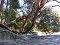
A few of the plants common to the island include the trees Douglas-firDouglas-fir
Douglas-fir is one of the English common names for evergreen coniferous trees of the genus Pseudotsuga in the family Pinaceae. Other common names include Douglas tree, and Oregon pine. There are five species, two in western North America, one in Mexico, and two in eastern Asia...
, Western redcedar
Thuja plicata
Thuja plicata, commonly called Western or pacific red cedar, giant or western arborvitae, giant cedar, or shinglewood, is a species of Thuja, an evergreen coniferous tree in the cypress family Cupressaceae native to western North America...
, arbutus
Pacific Madrone
Arbutus menziesii, commonly known as the Pacific Madrone, is a species of Arbutus found on the west coast of North America, from British Columbia to California...
, Garry oak
Garry Oak
Quercus garryana, the Garry Oak, Oregon White Oak or Oregon Oak, has a range from southern California to extreme southwestern British Columbia, particularly southeastern Vancouver Island and the adjacent Gulf Islands. It grows from sea level to 210 m altitude in the northern part of its range, and...
, bigleaf maple, and red alder; the shrubs Oregon-grape, and red-flowering currant
Ribes sanguineum
Ribes sanguineum is a species of currant native to western coastal North America from central British Columbia south to central California.-Description:...
; the perennial herb small camas (common camas); the semi-aquatic or terrestrial herb Western skunk cabbage
Western Skunk Cabbage
Western Skunk Cabbage , also called Yellow Skunk Cabbage or Swamp Lantern, is a plant found in swamps and wet woods, along streams and in other wet areas of the Pacific Northwest, where it is one of the few native species in the arum family. The plant is called Skunk Cabbage because of the...
(swamp lantern), and the evergreen perennial Western sword fern
Polystichum munitum
Polystichum munitum is an evergreen fern native to western North America, where it is one of the most abundant ferns occurring along the Pacific coast from southeast Alaska south to southern California, and also inland east to southeastern British Columbia, northern Idaho and western Montana, with...
.
Sea creatures near Gabriola include orca
Orca
The killer whale , commonly referred to as the orca, and less commonly as the blackfish, is a toothed whale belonging to the oceanic dolphin family. Killer whales are found in all oceans, from the frigid Arctic and Antarctic regions to tropical seas...
s (killer whales), sea lions, seals, otters, oysters, mussels, clams, wolf eels, octopuses, and salmon. Deer and raccoons are among the island's more common land animals.
In the winter months, the coast of Gabriola is visited by many species of waterfowl such as the Scoter
Scoter
The scoters are stocky seaducks in the genus Melanitta. The drakes are mostly black and have swollen bills. Females are brown.They breed in the far north of Europe, Asia and North America, and winter further south in temperate zones of those continents. They form large flocks on suitable coastal...
, Bufflehead
Bufflehead
The Bufflehead is a small American sea duck of the genus Bucephala, the goldeneyes. This species was first described by Linnaeus in his Systema naturae in 1758 as Anas albeola.-Description:...
, Barrow's Goldeneye
Barrow's Goldeneye
Barrow's Goldeneye is a medium-sized sea duck of the genus Bucephala, the goldeneyes. This bird was named after Sir John Barrow....
, and Harlequin Duck
Harlequin Duck
The Harlequin Duck is a small sea duck. It takes its name from Arlecchino, Harlequin in French, a colourfully dressed character in Commedia dell'arte. The species name comes from the Latin word "histrio", "actor". In North America it is also known as Lords and ladies...
. Shorebirds such as the Black Turnstone
Black Turnstone
The Black Turnstone is a species of small wading bird. It is one of two species of turnstone in the genus Arenaria, the Ruddy Turnstone being the other. It is now classified in the sandpiper family Scolopacidae but was formerly sometimes placed in the plover family Charadriidae...
and Ruddy Turnstone
Ruddy Turnstone
The Ruddy Turnstone is a small wading bird, one of two species of turnstone in the genus Arenaria. It is now classified in the sandpiper family Scolopacidae but was formerly sometimes placed in the plover family Charadriidae...
frequent the island as do garden birds such as the Ruby-crowned Kinglet, Golden-crowned Kinglet
Golden-crowned Kinglet
The Golden-crowned Kinglet, Regulus satrapa, is a very small songbird.Adults are olive-gray on the upperparts with white underparts, with thin bills and short tails. They have white wing bars, a black stripe through the eyes and a yellow crown surrounded by black...
, Thrush
Thrush (bird)
The thrushes, family Turdidae, are a group of passerine birds that occur worldwide.-Characteristics:Thrushes are plump, soft-plumaged, small to medium-sized birds, inhabiting wooded areas, and often feed on the ground or eat small fruit. The smallest thrush may be the Forest Rock-thrush, at and...
es, Warbler
Warbler
There are a number of Passeriformes called "warblers". They are not particularly closely related, but share some characteristics, such as being fairly small, vocal and insectivorous....
s, Pileated Woodpecker
Pileated Woodpecker
The Pileated Woodpecker is a very large North American woodpecker, almost crow-sized, inhabiting deciduous forests in eastern North America, the Great Lakes, the boreal forests of Canada, and parts of the Pacific coast. It is also the largest woodpecker in America.Adults are long, and weigh...
s, and Flicker
Northern Flicker
The Northern Flicker is a medium-sized member of the woodpecker family. It is native to most of North America, parts of Central America, Cuba, the Cayman Islands, and is one of the few woodpecker species that migrate. There are over 100 common names for the Northern Flicker...
s. The Bald Eagle
Bald Eagle
The Bald Eagle is a bird of prey found in North America. It is the national bird and symbol of the United States of America. This sea eagle has two known sub-species and forms a species pair with the White-tailed Eagle...
, European Starling
European Starling
The Common Starling , also known as the European Starling or just Starling, is a passerine bird in the family Sturnidae.This species of starling is native to most of temperate Europe and western Asia...
, and Turkey Vulture
Turkey Vulture
The Turkey Vulture is a bird found throughout most of the Americas. It is also known in some North American regions as the Turkey Buzzard , and in some areas of the Caribbean as the John Crow or Carrion Crow...
are common year round. More than 250 bird species live in or migrate through the Nanaimo–Gabriola area.