
Baja California
Encyclopedia
Baja California (ˈbaxa kaliˈfornja, ˈbɑːhɑː kælɨˈfɔrnjə) officially Estado Libre y Soberano de Baja California (Free and Sovereign State of Lower California) is one of the 31 states which, with the Federal District
, comprise the 32 Federal Entities of Mexico
. It is both the northernmost and westernmost state of Mexico. Before becoming a state in 1953, the area was known as the North Territory of Baja California. It has an area of 70113 km² (27,071 sq mi), or 3.57% of the land mass of Mexico and comprises the northern half of the Baja California peninsula
, north of the 28th parallel
. The state is bordered on the west by the Pacific Ocean, on the east by Sonora
, the U.S. State
of Arizona
, and the Gulf of California
(also known as the Sea of Cortez), and on the south by Baja California Sur
. Its northern limit is the U.S. state of California
.
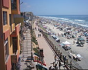
The state has a population of 2,844,469 (2005 census), and estimated 3,165,776 (June 2009) much more than the sparsely populated Baja California Sur to the south, and similar to San Diego County on its north. Over 75% of the population lives in the capital city, Mexicali
, or in Ensenada
and Tijuana
. Other important cities include San Felipe
, Rosarito and Tecate
. The population of the state is composed of Mestizos, mostly immigrants from other parts of Mexico, and, as with most northern Mexican states, a large population of Mexicans of European
ancestry, and also a large minority group of East Asian, Middle Eastern and indigenous descent. Additionally, there is a large immigrant population from the United States due to its proximity to San Diego and the cheaper cost of living compared to San Diego. There is also a significant population from Central America. Many immigrants moved to Baja California for a better quality of life and the number of higher paying jobs in comparison to the rest of Mexico and Latin America
.
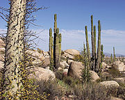
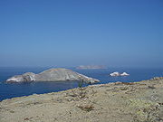
Baja California is the twelfth largest state by area in Mexico. Its geography ranges from beaches to forests and deserts. The backbone of the state is the Sierra de Baja California, where the Picacho del Diablo
, the highest point of the peninsula, is located. This mountain range effectively divides the weather patterns in the state. In the northwest, the weather is semi-dry and mediterranean. In the narrow center, the weather changes to be more humid due to altitude. It is in this area where a few valleys can be found, such as the Valle de Guadalupe, the major wine producing area in Mexico. To the east of the mountain range, the Sonoran Desert
dominates the landscape. In the south, the weather becomes drier and gives way to the Vizcaino Desert. The state is also home to numerous islands off both of its shores. In fact, the westernmost point in Mexico, the Guadalupe Island
, is part of Baja California. The Coronado
, Todos Santos
and Cedros Island
s are also on the Pacific Shore. On the Gulf of California, the biggest island is the Angel de la Guarda, separated from the peninsula by the deep and narrow Canal de Ballenas
.
. In the north were several groups belonging to the Yuman language family, including the Kiliwa
, Paipai
, Kumeyaay
, Cocopa
, and Quechan
. These peoples were diverse in their adaptations to the region. The Cochimí
of the peninsula's Central Desert were generalized hunter-gatherers who moved frequently; however, the Cochimí on Cedros Island
off the west coast had developed a strongly maritime economy. The Kiliwa, Paipai, and Kumeyaay in the better-watered northwest were also hunter-gatherers, but that region supported denser populations and a more sedentary lifestyle. The Cocopa and Quechan of northeastern Baja California practiced agriculture in the floodplain of the lower Colorado River.
Europeans reached the present state of Baja California in 1539, when Francisco de Ulloa
reconnoitered its east coast on the Gulf of California
and explored the peninsula's west coast at least as far north as Cedros Island. Hernando de Alarcón
returned to the east coast and ascended the lower Colorado River in 1540, and Juan Rodríguez Cabrillo
(or Joan Rodrigues Cabrilho ) completed the reconnaissance of the west coast in 1542. Sebastián Vizcaíno
again surveyed the west coast in 1602, but outside visitors during the following century were few.
The Jesuits
founded a permanent mission colony on the peninsula at Loreto
in 1697. During the following decades, they gradually extended their sway throughout the present state of Baja California Sur. In 1751–1753, the Croatian Jesuit mission-explorer Ferdinand Konščak
made overland explorations northward into the state of Baja California. Jesuit missions were subsequently established among the Cochimí at Santa Gertrudis
(1752), San Borja
(1762), and Santa María
(1767).
After the expulsion of the Jesuits
in 1768, the short-lived Franciscan
administration (1768–1773) resulted in one new mission at San Fernando Velicatá
. More importantly, the 1769 expedition to settle Alta California under Gaspar de Portolà
and Junípero Serra
resulted in the first overland exploration of the northwestern portion of the state.
The Dominicans
took over management of the Baja California missions from the Franciscans in 1773. They established a chain of new missions among the northern Cochimí and western Yumans, first on the coast and subsequently inland, extending from El Rosario
(1774) to Descanso
(1817), just south of Tijuana.
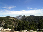
Baja California encompasses a territory which exhibits diverse geography for a relatively small area. The Peninsula Ranges of the California cordillera run down the geographic center of the state. The most notable ranges of these mountains are the Sierra de Juarez and the Sierra de San Pedro Martir
. These ranges are the location of forests cognizant of Southern California
's San Gabriel Mountains
. Picacho del Diablo is the highest peak in the whole peninsula. Valleys between the mountain ranges are located within a climate zone that are suitable for agriculture. Such valleys included the Valle de Guadalupe and the Valle de Ojos Negros, areas that produce citrus fruits and grapes. The mineral rich mountain range extends southwards to the Gulf of California where the western slope becomes wider, forming the Llanos del Berrendo in the border with Baja California Sur. The mountain ranges located in the center and southern part of the state include the Sierra de La Asamblea, Sierra de Calamajué, Sierra de San Luis and the Sierra de San Borja.
Temperate winds from the Pacific Ocean and the cold California Current
make the climate along the northwestern coast pleasant year round. Resulting from the states location on the California current, rains from the north barely reach the peninsula and leaves southern areas drier. South of El Rosario River the state changes from a Mediterranean landscape to a desert one. This desert exhibits diversity in succulent flora species that flourish in part due to the coastal fog.
To the east, the Sonoran Desert
enters the state from both California and Sonora. Some of the highest temperatures in Mexico are recorded in or nearby the Mexicali Valley. However, with irrigation from the Colorado River, this area has become truly an agricultural center. The Cerro Prieto geothermal province is near Mexicali as well (this area is geologically part of a large pull apart basin); producing about 80% of the electricity consumed in the state and enough more to export to California. Laguna Salada, a saline lake below sea level lying between the rugged Sierra de Juarez and the Sierra de los Cucapah, is also in the vicinity of Mexicali. The state government has recently been considering plans to revive Laguna Salada. The highest mountain in the Sierra de los Cucapah is the Cerro del Centinela or Mount Signal. The Cucapah are the primary indigenous people of that area and up into the Yuma, AZ area.
There are numerous islands on the Pacific shore. Guadalupe Island
is located in the extreme west of the state's boundaries and is the site of large colonies of sea lions. Cedros Island
exists in the southwest of the state's maritime region. The Todos Santos Islands and Coronado Islands
are located off the coast of Tijuana and Ensenada. All of the islands in the Gulf of California, on the Baja California side, belong to the municipality of Mexicali.
Baja California obtains much of its water from the Colorado River
. Historically the river drained into the Colorado River Delta
which flowed into the Gulf of California
, but due to large demands for water in the American Southwest, less water now reaches the Gulf. The Tijuana metropolitan area
also relies on the Tijuana River
as a source of water. Much of rural Baja California depends predominantly on wells and a few dams. Tijuana also purchases water from San Diego County's Otay Water District. Potable water is the largest natural resource issue of the state.
 Baja California's climate varies from Mediterranean
to arid climate zones. The Mediterranean climate
is observed in the northwestern corner of the state where the summers are dry and mild and the winters cool and rainy. This climate is observed in areas from Tijuana to San Quintin and nearby interior valleys. The cold oceanic California Current
often creates a low-level marine fog
near the coast. The fog occurs along any part of the Pacific Coast of the state.
The change of altitude towards the Sierra de Baja California creates an alpine climate in this region. Summers are cool while winters can be cold with below freezing temperatures at night. It is common to see snow in the Sierra de Juarez and Sierra de San Pedro Martir (and in the valleys in between) from December to April.
The east side of the mountains produce a rain shadow
, creating an extremely arid environment. The Sonoran Desert region of Baja California experiences hot summers and nearly frostless mild winters. The Mexicali Valley (which is below sea level), experiences the highest temperatures in Mexico, that frequently surpass 47 °C (116.6 °F) in mid-summer, and have exceeded 50 °C (122 °F) on some occasions.
Further south along the Pacific coast, the arid climate remains but it is milder and not as hot as along the gulf coast. Transition climates, from Mediterranean to Desert, can be found from San Quintin to El Rosario. Further inland and along the Gulf of California the vegetation is scarce and temperatures are very high during the summer months. The islands in the Gulf of California also belong to the desert climate. Some oases can be found in the desert in which few towns are located – for instance, Catavina, San Borja and Santa Gertrudis.
, Sugar Pine
and Pinon Pine. Understory species include Manzanita
. Fauna include a variety of reptiles including the Western fence lizard
, which is at the southern extent of its range. The name of the fish genus Bajacalifornia
is derived from the Baja California peninsula.
In the main terrestrial wildlife refuges on the peninsula of Baja California, Constitution 1857 National Park
and Sierra de San Pedro Mártir National Park
contain several coniferous species; the most abundant are: pinus jeffreyi, pinus ponderosa, pinus cembroide, pinus quadrifolia, pinus monophylla, juniperus, arctostaphylos drupacea, artemisa ludoviciana, and adenostoma esparcifolium. The flora shares many species with the Laguna Mountains
and San Jacinto Mountains
in southwest California. The lower elevations of the Sierra Juárez are characterized by chaparral
and desert shrub.
The fauna in the parks exhibit a large number of mammals primarily: Mule Deer
, Bighorn Sheep
, Cougar, Bobcat
, Ringtail Cat, Coyote
, Rabbit
, Squirrel
and more than 30 species of Bat
s. The park is also home to many avian species like: Bald Eagle
, Golden Eagle
, Falcon
, Woodpecker
, Black Vulture
, Crow
, several species of Sittidae
and Duck
.
). See municipalities of Baja California
.

magnitude northwest trending strike-slip earthquake hit the Mexicali Valley, with its epicenter 26 km southwest of the city of Guadalupe Victoria, Baja California, Mexico
. The main shock was felt as far as the Los Angeles, Las Vegas, Phoenix and Tucson metropolitan areas; in Yuma. At least a half-dozen aftershocks with magnitudes between 5.0 and 5.4 were reported, including a 5.1-magnitude shaker at 4:14 am. that was centered near El Centro. As of 6:31 am PDT, 5 April 2010, two people have been confirmed dead.
/European (mostly but not limited to people of descent), 36% Mestizo
(Mixed Amerindian and European), 9% east Asian, the remaining 15% is Native American (of Mexican and Central American origins, but includes Cherokees from the U.S. settled there in the 20th century) and a miniscule 1% of African descent.
Historically, the state has had sizable east Asian immigration, esp. Mexicali has a large Chinese community, as well as many Filipinos
from the Philippines arrived to the state during the eras of Spanish and later American rule (1898–1946) in much of the 19th and 20th centuries. Tijuana and Ensenada were a major port of entry for east Asians entering the U.S. ever since the first Asian-Americans were present in California.
Also a significant number of Middle Eastern immigrants such as Lebanese
, Syrians and Armenians
settle near the U.S. border, and small waves of settlers in the early 20th century, usually members of the Molokan
sect of the Russian Orthodox church fled the Russian Revolution of 1917 when the Soviet Union took power, had established a few villages along the Pacific coast south of Ensenada
.
Since 1960, large numbers of migrants from southern Mexican states have arrived to work in agriculture (esp. the Mexicali Valley and nearby Imperial Valley
, California, US) and manufacturing. The cities of Ensenada, Tijuana and Mexicali grew as a result of migrants, primarily those who sought US citizenship and those temporary residents awaiting their entry into the United States are called Flotillas, which is derived from the Spanish word "flota," meaning "fleet."
There is also a sizable immigrant community from Central
and South America, and from the United States and Canada. An estimated 200,000+ American expatriates live in the state, especially in coastal resort towns such as Ensenada
, known for affordable homes purchased by retirees who continue to hold US citizenship. San Felipe
, Rosarito and Tijuana
also have a large American population (second largest in Mexico next to Mexico City), particularly for its cheaper housing and proximity to San Diego.
About 92% of Baja California's population is Christian, 81% of them are Catholics.
Baja California has one of the best educational programs in the country, with high rankings in schooling and achievement.
The State Government provides education and qualification courses to increase the workforce standards, such as School-Enterprise linkage programs which helps the development of labor force according to the needs of the industry.
91.60% of the population from six to fourteen years of age attend elementary school. 61.95% of the population over fifteen years of age attend or have already graduated from high school. Public School is available in all levels, from kindergarten to university.
The state has 32 universities offering 103 professional degrees. These universities have 19 Research and Development centers for basic and applied investigation in advanced projects of Biotechnology, Physics, Oceanography, Digital Geothermal Technology, Astronomy, Aerospace, Electrical Engineering and Clean Energy, among others. At this educational level supply is steadily growing. Baja California has developed a need to be self-sufficient in matters of technological and scientific innovation and to be less dependent on foreign countries. Current businesses demand new production processes as well as technology for the incubation of companies. The number of various graduate degrees offered, including Ph.D. programs, is 121. The state has 53 graduate schools.
or 21,996 million USD. Baja California's economy has a strong focus on tariff-free export oriented manufacturing (maquiladora
). As of 2005, 284,255 people are employed in the manufacturing sector. There are a more than 900 companies operating under the federal Prosec
program in Baja California.
Any Mexican citizen buying a bank trust property has the option to either remain within the Trust or opt out of it and request the title in “Escritura”.
Mexico’s early history involved foreign invasions and the loss of vast amounts of land; in fear of history being repeated, the Mexican constitution established the concept of the “Restricted Zone”. In 1973, in order to bring in more foreign tourist investment, the Bank Trust of Fideicomiso was created, thus allowing non-Mexicans to own land without any constitutional amendment necessary. Since the law went into effect, it has undergone many modifications in order to make purchasing land in Mexico a safer investment.
Mexico City
Mexico City is the Federal District , capital of Mexico and seat of the federal powers of the Mexican Union. It is a federal entity within Mexico which is not part of any one of the 31 Mexican states but belongs to the federation as a whole...
, comprise the 32 Federal Entities of Mexico
Mexico
The United Mexican States , commonly known as Mexico , is a federal constitutional republic in North America. It is bordered on the north by the United States; on the south and west by the Pacific Ocean; on the southeast by Guatemala, Belize, and the Caribbean Sea; and on the east by the Gulf of...
. It is both the northernmost and westernmost state of Mexico. Before becoming a state in 1953, the area was known as the North Territory of Baja California. It has an area of 70113 km² (27,071 sq mi), or 3.57% of the land mass of Mexico and comprises the northern half of the Baja California peninsula
Baja California Peninsula
The Baja California peninsula , is a peninsula in northwestern Mexico. Its land mass separates the Pacific Ocean from the Gulf of California. The Peninsula extends from Mexicali, Baja California in the north to Cabo San Lucas, Baja California Sur in the south.The total area of the Baja California...
, north of the 28th parallel
28th parallel north
The 28th parallel north is a circle of latitude that is 28 degrees north of the Earth's equatorial plane. It crosses Africa, Asia, the Pacific Ocean, North America and the Atlantic Ocean....
. The state is bordered on the west by the Pacific Ocean, on the east by Sonora
Sonora
Sonora officially Estado Libre y Soberano de Sonora is one of the 31 states which, with the Federal District, comprise the 32 Federal Entities of Mexico. It is divided into 72 municipalities; the capital city is Hermosillo....
, the U.S. State
U.S. state
A U.S. state is any one of the 50 federated states of the United States of America that share sovereignty with the federal government. Because of this shared sovereignty, an American is a citizen both of the federal entity and of his or her state of domicile. Four states use the official title of...
of Arizona
Arizona
Arizona ; is a state located in the southwestern region of the United States. It is also part of the western United States and the mountain west. The capital and largest city is Phoenix...
, and the Gulf of California
Gulf of California
The Gulf of California is a body of water that separates the Baja California Peninsula from the Mexican mainland...
(also known as the Sea of Cortez), and on the south by Baja California Sur
Baja California Sur
Baja California Sur , is one of the 31 states which, with the Federal District, comprise the 32 Federal Entities of Mexico. Before becoming a state on October 8, 1974, the area was known as the South Territory of Baja California. It has an area of , or 3.57% of the land mass of Mexico and comprises...
. Its northern limit is the U.S. state of California
California
California is a state located on the West Coast of the United States. It is by far the most populous U.S. state, and the third-largest by land area...
.
The state has a population of 2,844,469 (2005 census), and estimated 3,165,776 (June 2009) much more than the sparsely populated Baja California Sur to the south, and similar to San Diego County on its north. Over 75% of the population lives in the capital city, Mexicali
Mexicali
Mexicali is the capital of the State of Baja California, seat of the Municipality of Mexicali, and 2nd largest city in Baja California. The City of Mexicali has a population of 689,775, according to the 2010 census, while the population of the entire metropolitan area reaches 936,826.The city...
, or in Ensenada
Ensenada, Baja California
Ensenada is a coastal city in Mexico and the third-largest city in Baja California. It is located south of San Diego on the Baja California Peninsula. The city is locally referred to as La Cenicienta del Pacífico, or, The Cinderella of the Pacific...
and Tijuana
Tijuana
Tijuana is the largest city on the Baja California Peninsula and center of the Tijuana metropolitan area, part of the international San Diego–Tijuana metropolitan area. An industrial and financial center of Mexico, Tijuana exerts a strong influence on economics, education, culture, art, and politics...
. Other important cities include San Felipe
San Felipe, Baja California
San Felipe is a town on the Gulf of California in the Mexican state of Baja California, 190 km south of the United States border and within the municipality of Mexicali. It also serves as a borough seat of its surrouding area....
, Rosarito and Tecate
Tecate
Tecate is a small city in Baja California, Mexico and the municipal seat of Tecate Municipality. It is located on the border with Tecate, California, United States in the San Diego–Tijuana metropolitan area. There is a small port of entry betwixt the sister cities that serves as a calmer...
. The population of the state is composed of Mestizos, mostly immigrants from other parts of Mexico, and, as with most northern Mexican states, a large population of Mexicans of European
White Mexican
Mexicans of European descent, often called "güeros" or blancos in Mexican Spanish, are generally those of light skin and predominantly European features which are most often associated with Mexico's upper and middle socioeconomic classes...
ancestry, and also a large minority group of East Asian, Middle Eastern and indigenous descent. Additionally, there is a large immigrant population from the United States due to its proximity to San Diego and the cheaper cost of living compared to San Diego. There is also a significant population from Central America. Many immigrants moved to Baja California for a better quality of life and the number of higher paying jobs in comparison to the rest of Mexico and Latin America
Latin America
Latin America is a region of the Americas where Romance languages – particularly Spanish and Portuguese, and variably French – are primarily spoken. Latin America has an area of approximately 21,069,500 km² , almost 3.9% of the Earth's surface or 14.1% of its land surface area...
.
Baja California is the twelfth largest state by area in Mexico. Its geography ranges from beaches to forests and deserts. The backbone of the state is the Sierra de Baja California, where the Picacho del Diablo
Picacho del Diablo
Picacho del Diablo is the highest peak in Baja California, measuring . It is alternately called Cerro de la Encantada, "Hill of the Enchanted." The peak is located in the Sierra San Pedro Martir in the Mexican state of Baja California Norte....
, the highest point of the peninsula, is located. This mountain range effectively divides the weather patterns in the state. In the northwest, the weather is semi-dry and mediterranean. In the narrow center, the weather changes to be more humid due to altitude. It is in this area where a few valleys can be found, such as the Valle de Guadalupe, the major wine producing area in Mexico. To the east of the mountain range, the Sonoran Desert
Sonoran Desert
The Sonoran Desert is a North American desert which straddles part of the United States-Mexico border and covers large parts of the U.S. states of Arizona and California and the northwest Mexican states of Sonora, Baja California, and Baja California Sur. It is one of the largest and hottest...
dominates the landscape. In the south, the weather becomes drier and gives way to the Vizcaino Desert. The state is also home to numerous islands off both of its shores. In fact, the westernmost point in Mexico, the Guadalupe Island
Guadalupe Island
Guadalupe Island, or Isla Guadalupe is a volcanic island located 241 kilometers off the west coast of Mexico's Baja California peninsula and some 400 kilometers southwest of the city of Ensenada in Baja California state, in the Pacific Ocean...
, is part of Baja California. The Coronado
Coronado Islands
The Coronado Islands are a group of four islands off the northwest coast of the Mexican state of Baja California. Battered by the wind and waves, they are largely infertile and uninhabited except for a small military detachment and a few lighthouse keepers...
, Todos Santos
Isla Todos Santos
Isla Todos Santos is a pair of islands about 19.3km off Ensenada, Baja California at best known for surfing. Access is only by boat, which can be rented out from Ensenada, or La Bufadora. The waves off the smallest island are some of the biggest waves in the North American continent, rivaled in...
and Cedros Island
Cedros Island
Cedros Island is a Mexican island in the Pacific Ocean....
s are also on the Pacific Shore. On the Gulf of California, the biggest island is the Angel de la Guarda, separated from the peninsula by the deep and narrow Canal de Ballenas
Ballenas Fault
The Ballenas Fault is a transform fault located on the seabed of the Gulf of California, extending through the Canal de Ballenas which separates the Isla Ángel de la Guarda from the Baja California Peninsula. The fault is an integral part of the East Pacific Rise, linking the Delfin Basin in the...
.
History
The first people came to the peninsula at least 11,000 years ago. At that time two main native groups are thought to have been present on the peninsula. In the south were the CochimíCochimi
The Cochimí are the aboriginal inhabitants of the central part of the Baja California peninsula, from El Rosario in the north to San Javier in the south....
. In the north were several groups belonging to the Yuman language family, including the Kiliwa
Kiliwa
The Kiliwa are an aboriginal people of northern Baja California, Mexico. They occupied a territory lying between the Cochimí on the south and the Paipai on the north, and extending from San Felipe on the Gulf of California to San Quintín on the Pacific coast...
, Paipai
Paipai
The Paipai are an aboriginal people of northern Baja California, Mexico. They occupied a territory lying between the Kiliwa on the south and the Kumeyaay and Cocopa on the north, and extending from San Vicente near the Pacific coast nearly to the Colorado River's delta in the east...
, Kumeyaay
Kumeyaay
The Kumeyaay, also known as Tipai-Ipai, Kamia, or formerly Diegueño, are Native American people of the extreme southwestern United States and northwest Mexico. They live in the states of California in the US and Baja California in Mexico. In Spanish, the name is commonly spelled...
, Cocopa
Cocopa
The Cocopah or Cocopa are Native American people who live in Baja California and Sonora, Mexico, and in Arizona in the United States. The Cocopah language belongs to the Delta–California branch of the Yuman family. In Spanish, the Cocopah are termed Cucapá...
, and Quechan
Quechan
The Quechan are a Native American tribe who live on the Fort Yuma Indian Reservation on the lower Colorado River in Arizona and California just north of the border with Mexico...
. These peoples were diverse in their adaptations to the region. The Cochimí
Cochimi
The Cochimí are the aboriginal inhabitants of the central part of the Baja California peninsula, from El Rosario in the north to San Javier in the south....
of the peninsula's Central Desert were generalized hunter-gatherers who moved frequently; however, the Cochimí on Cedros Island
Cedros Island
Cedros Island is a Mexican island in the Pacific Ocean....
off the west coast had developed a strongly maritime economy. The Kiliwa, Paipai, and Kumeyaay in the better-watered northwest were also hunter-gatherers, but that region supported denser populations and a more sedentary lifestyle. The Cocopa and Quechan of northeastern Baja California practiced agriculture in the floodplain of the lower Colorado River.
Europeans reached the present state of Baja California in 1539, when Francisco de Ulloa
Francisco de Ulloa
Francisco de Ulloa was a Spanish explorer who explored the west coast of present-day Mexico under the commission of Hernán Cortés...
reconnoitered its east coast on the Gulf of California
Gulf of California
The Gulf of California is a body of water that separates the Baja California Peninsula from the Mexican mainland...
and explored the peninsula's west coast at least as far north as Cedros Island. Hernando de Alarcón
Hernando de Alarcón
Hernando de Alarcón, a Spanish navigator of the 16th century, noted for having led an early expedition to the Baja California peninsula, meant to be coordinated with Francisco Vasquéz de Coronado's overland expedition, and for penetrating the lower Colorado River, perhaps as far as the modern...
returned to the east coast and ascended the lower Colorado River in 1540, and Juan Rodríguez Cabrillo
Juan Rodríguez Cabrillo
Juan Rodriguez Cabrillo was a Portuguese explorer noted for his exploration of the west coast of North America on behalf of Spain. Cabrillo was the first European explorer to navigate the coast of present day California in the United States...
(or Joan Rodrigues Cabrilho ) completed the reconnaissance of the west coast in 1542. Sebastián Vizcaíno
Sebastián Vizcaíno
Sebastián Vizcaíno was a Spanish soldier, entrepreneur, explorer, and diplomat whose varied roles took him to New Spain, the Philippines, the Baja California peninsula, the California coast and Japan.-Early career:...
again surveyed the west coast in 1602, but outside visitors during the following century were few.
The Jesuits
Society of Jesus
The Society of Jesus is a Catholic male religious order that follows the teachings of the Catholic Church. The members are called Jesuits, and are also known colloquially as "God's Army" and as "The Company," these being references to founder Ignatius of Loyola's military background and a...
founded a permanent mission colony on the peninsula at Loreto
Loreto, Baja California Sur
Loreto was the first Spanish settlement on the Baja California Peninsula. It served as the capital of Las Californias from 1697 to 1777, and is the current seat of the municipality of Loreto in the Mexican state of Baja California Sur...
in 1697. During the following decades, they gradually extended their sway throughout the present state of Baja California Sur. In 1751–1753, the Croatian Jesuit mission-explorer Ferdinand Konščak
Ferdinand Konšcak
Ferdinand Konščak was a Jesuit missionary, explorer, and cartographer.-Education:...
made overland explorations northward into the state of Baja California. Jesuit missions were subsequently established among the Cochimí at Santa Gertrudis
Misión Santa Gertrudis
Mission Santa Gertrudis, called Dolores del Norte by some historians, was founded by the Jesuit missionary Jorge Retz in 1751 among the Cochimí Indians of the Baja California Peninsula, about 80 kilometers north of San Ignacio...
(1752), San Borja
Misión San Francisco Borja
San Borja was a Spanish mission established in 1762 by the Jesuit Wenceslaus Linck at the Cochimí settlement of Adac, west of Bahía de los Ángeles....
(1762), and Santa María
Misión Santa María de los Ángeles
Mission Santa María de los Ángeles was the last of the missions established by the Jesuits in Baja California, Mexico, in 1767. The site chosen was the Cochimí settlement of Cabujakaamung , west of Bahía San Luis Gonzaga near the Gulf of California coast, about 22 kilometers east of Rancho Santa...
(1767).
After the expulsion of the Jesuits
Suppression of the Jesuits
The Suppression of the Jesuits in the Portuguese Empire, France, the Two Sicilies, Parma and the Spanish Empire by 1767 was a result of a series of political moves rather than a theological controversy. By the brief Dominus ac Redemptor Pope Clement XIV suppressed the Society of Jesus...
in 1768, the short-lived Franciscan
Franciscan
Most Franciscans are members of Roman Catholic religious orders founded by Saint Francis of Assisi. Besides Roman Catholic communities, there are also Old Catholic, Anglican, Lutheran, ecumenical and Non-denominational Franciscan communities....
administration (1768–1773) resulted in one new mission at San Fernando Velicatá
Misión San Fernando Rey de España de Velicatá
Located in Baja California, Mexico about 200 miles south of Ensenada, Misión San Fernando Rey de España de Velicatá was the only mission founded by Franciscans in Baja California....
. More importantly, the 1769 expedition to settle Alta California under Gaspar de Portolà
Gaspar de Portolà
Gaspar de Portolà i Rovira was a soldier, governor of Baja and Alta California , explorer and founder of San Diego and Monterey. He was born in Os de Balaguer, province of Lleida, in Catalonia, Spain, of Catalan nobility. Don Gaspar served as a soldier in the Spanish army in Italy and Portugal...
and Junípero Serra
Junípero Serra
Blessed Junípero Serra, O.F.M., , known as Fra Juníper Serra in Catalan, his mother tongue was a Majorcan Franciscan friar who founded the mission chain in Alta California of the Las Californias Province in New Spain—present day California, United States. Fr...
resulted in the first overland exploration of the northwestern portion of the state.
The Dominicans
Dominican Order
The Order of Preachers , after the 15th century more commonly known as the Dominican Order or Dominicans, is a Catholic religious order founded by Saint Dominic and approved by Pope Honorius III on 22 December 1216 in France...
took over management of the Baja California missions from the Franciscans in 1773. They established a chain of new missions among the northern Cochimí and western Yumans, first on the coast and subsequently inland, extending from El Rosario
Misión Nuestra Señora del Santísimo Rosario de Viñacado
Mission El Rosario was the first Dominican mission in Baja California, established in 1774 by Vicente Mora and Francisco Galisteo near the modern town of El Rosario....
(1774) to Descanso
Misión El Descanso
Mission El Descanso was founded in 1817 among the Kumeyaay by Dominican missionary Tomás de Ahumada at a site 22 kilometers south of the present-day city of Rosarito, Baja California, Mexico....
(1817), just south of Tijuana.
Nineteenth and twentieth centuries
- 1804: The Spanish colony of California was divided into Alta ("Upper")Alta CaliforniaAlta California was a province and territory in the Viceroyalty of New Spain and later a territory and department in independent Mexico. The territory was created in 1769 out of the northern part of the former province of Las Californias, and consisted of the modern American states of California,...
and Baja ("Lower") CaliforniaBaja California PeninsulaThe Baja California peninsula , is a peninsula in northwestern Mexico. Its land mass separates the Pacific Ocean from the Gulf of California. The Peninsula extends from Mexicali, Baja California in the north to Cabo San Lucas, Baja California Sur in the south.The total area of the Baja California...
at the line separating the FranciscanFranciscanMost Franciscans are members of Roman Catholic religious orders founded by Saint Francis of Assisi. Besides Roman Catholic communities, there are also Old Catholic, Anglican, Lutheran, ecumenical and Non-denominational Franciscan communities....
missions in the north from the DominicanDominican OrderThe Order of Preachers , after the 15th century more commonly known as the Dominican Order or Dominicans, is a Catholic religious order founded by Saint Dominic and approved by Pope Honorius III on 22 December 1216 in France...
missions in the south.
- The colonial governors were:
-
- 1804–1805 José Joaquín de Arillaga (s.a.)
- 1806–1814 Felipe de Goycoechea
- 1814 – 11 April 1822 José Darío ArgüelloJosé Darío ArgüelloJosé Darío Argüello was a Spanish soldier and California pioneer, and twice governor of California.-Biography:José Darío Argüello was born in Santiago de Querétaro, New Spain ....
- 1848: Alta CaliforniaAlta CaliforniaAlta California was a province and territory in the Viceroyalty of New Spain and later a territory and department in independent Mexico. The territory was created in 1769 out of the northern part of the former province of Las Californias, and consisted of the modern American states of California,...
is annexed by the United States. - 1853: Soldier of fortune William Walker captures La PazLa Paz, Baja California SurLa Paz is the capital city of the Mexican state of Baja California Sur and an important regional commercial center. The city had a 2010 census population of 215,178 persons, but its metropolitan population is somewhat larger because of surrounding towns like el Centenario, el Zacatal and San Pedro...
, declaring himself President of the Republic of Lower California. The Mexican government forces his retreat after several months. - 1884: Luis Huller and George H. SissonGeorge H. SissonGeorge H. Sisson was a nineteenth century American entrepreneur. He was born in Michigan, and was an early real estate developer in Chicago. He was a mining engineer in Arizona, and with his profits from that operation, purchased a large land concession in Baja California.-Baja California and...
obtain a concession covering much of the present state, in return for promises to develop the area. - 1905: The Magonista revolution, an anarchistAnarchismAnarchism is generally defined as the political philosophy which holds the state to be undesirable, unnecessary, and harmful, or alternatively as opposing authority in the conduct of human relations...
movement based on the writings of Ricardo Flores MagónRicardo Flores MagónCipriano Ricardo Flores Magón was a noted Mexican anarchist and social reform activist. His brothers Enrique and Jesús were also active in politics. Followers of the Magón brothers were known as Magonistas....
and Enrique Flores MagónEnrique Flores MagónEnrique Flores Magón was a Mexican journalist and politician, associated with the Mexican Liberal Party and anarchism...
, begins. - 1911: Mexicali and Tijuana are captured by the Mexican Liberal PartyMexican Liberal PartyThe Mexican Liberal Party was an anarchist group co-founded by Ricardo Flores Magón in 1906, in opposition to the rule of Porfirio Díaz. The MLP was involved in strikes and uprisings in Mexico from 1906 to 1911. The party controlled most parts of Baja California in 1911, including Tijuana,...
(Partido Liberal Mexicano, PLM), but soon surrender to Federal forces. - 1917: On December 11, "[a] prominent Mexican, close friend of President CarranzaVenustiano CarranzaVenustiano Carranza de la Garza, was one of the leaders of the Mexican Revolution. He ultimately became President of Mexico following the overthrow of the dictatorial Huerta regime in the summer of 1914 and during his administration the current constitution of Mexico was drafted...
" offered to U. S. Senator Henry AshurstHenry F. AshurstHenry Fountain Ashurst was an American Democratic politician and one of the first two Senators from Arizona. Largely self-educated, he served as a district attorney and member of the Arizona Territorial legislature before fulfilling his childhood ambition of joining the United States Senate...
to sell Baja California to the U. S. for "fifty million dollars gold." - 1930: Baja California is further divided into Northern and Southern territories.
- 1952: The North Territory of Baja California becomes the 29th state of Mexico, Baja California. The southern portion, below 28°N, remains a federally administered territory.
- 1974: The South Territory of Baja California becomes the 31st state, Baja California SurBaja California SurBaja California Sur , is one of the 31 states which, with the Federal District, comprise the 32 Federal Entities of Mexico. Before becoming a state on October 8, 1974, the area was known as the South Territory of Baja California. It has an area of , or 3.57% of the land mass of Mexico and comprises...
. - 1989: Ernesto Ruffo AppelErnesto Ruffo AppelErnesto Ruffo Appel is an American-born Mexican politician famous for being the first state governor not belonging to the Partido Revolucionario Institucional since its formation in 1929....
of the PANNational Action Party (Mexico)The National Action Party , is one of the three main political parties in Mexico. The party's political platform is generally considered Centre-Right in the Mexican political spectrum. Since 2000, the President of Mexico has been a member of this party; both houses have PAN pluralities, but the...
becomes the first non-PRIInstitutional Revolutionary PartyThe Institutional Revolutionary Party is a Mexican political party that held power in the country—under a succession of names—for more than 70 years. The PRI is a member of the Socialist International, as is the rival Party of the Democratic Revolution , making Mexico one of the few...
governor of Baja California and the first opposition governor of any state since the RevolutionMexican RevolutionThe Mexican Revolution was a major armed struggle that started in 1910, with an uprising led by Francisco I. Madero against longtime autocrat Porfirio Díaz. The Revolution was characterized by several socialist, liberal, anarchist, populist, and agrarianist movements. Over time the Revolution...
.
- 1848: Alta California
-
Geography
Baja California encompasses a territory which exhibits diverse geography for a relatively small area. The Peninsula Ranges of the California cordillera run down the geographic center of the state. The most notable ranges of these mountains are the Sierra de Juarez and the Sierra de San Pedro Martir
San Pedro Mártir
San Pedro Mártir may refer to:*Sierra San Pedro Mártir, a mountain range on Mexico's Baja California Peninsula, part of which is:**Parque Nacional Sierra de San Pedro Mártir, a national park...
. These ranges are the location of forests cognizant of Southern California
Southern California
Southern California is a megaregion, or megapolitan area, in the southern area of the U.S. state of California. Large urban areas include Greater Los Angeles and Greater San Diego. The urban area stretches along the coast from Ventura through the Southland and Inland Empire to San Diego...
's San Gabriel Mountains
San Gabriel Mountains
The San Gabriel Mountains Range is located in northern Los Angeles County and western San Bernardino County, California, United States. The mountain range lies between the Los Angeles Basin and the Mojave Desert, with Interstate 5 to the west and Interstate 15 to the east...
. Picacho del Diablo is the highest peak in the whole peninsula. Valleys between the mountain ranges are located within a climate zone that are suitable for agriculture. Such valleys included the Valle de Guadalupe and the Valle de Ojos Negros, areas that produce citrus fruits and grapes. The mineral rich mountain range extends southwards to the Gulf of California where the western slope becomes wider, forming the Llanos del Berrendo in the border with Baja California Sur. The mountain ranges located in the center and southern part of the state include the Sierra de La Asamblea, Sierra de Calamajué, Sierra de San Luis and the Sierra de San Borja.
Temperate winds from the Pacific Ocean and the cold California Current
California Current
The California Current is a Pacific Ocean current that moves south along the western coast of North America, beginning off southern British Columbia, and ending off southern Baja California. There are five major coastal currents affiliated with upwelling zones...
make the climate along the northwestern coast pleasant year round. Resulting from the states location on the California current, rains from the north barely reach the peninsula and leaves southern areas drier. South of El Rosario River the state changes from a Mediterranean landscape to a desert one. This desert exhibits diversity in succulent flora species that flourish in part due to the coastal fog.
To the east, the Sonoran Desert
Sonoran Desert
The Sonoran Desert is a North American desert which straddles part of the United States-Mexico border and covers large parts of the U.S. states of Arizona and California and the northwest Mexican states of Sonora, Baja California, and Baja California Sur. It is one of the largest and hottest...
enters the state from both California and Sonora. Some of the highest temperatures in Mexico are recorded in or nearby the Mexicali Valley. However, with irrigation from the Colorado River, this area has become truly an agricultural center. The Cerro Prieto geothermal province is near Mexicali as well (this area is geologically part of a large pull apart basin); producing about 80% of the electricity consumed in the state and enough more to export to California. Laguna Salada, a saline lake below sea level lying between the rugged Sierra de Juarez and the Sierra de los Cucapah, is also in the vicinity of Mexicali. The state government has recently been considering plans to revive Laguna Salada. The highest mountain in the Sierra de los Cucapah is the Cerro del Centinela or Mount Signal. The Cucapah are the primary indigenous people of that area and up into the Yuma, AZ area.
There are numerous islands on the Pacific shore. Guadalupe Island
Guadalupe Island
Guadalupe Island, or Isla Guadalupe is a volcanic island located 241 kilometers off the west coast of Mexico's Baja California peninsula and some 400 kilometers southwest of the city of Ensenada in Baja California state, in the Pacific Ocean...
is located in the extreme west of the state's boundaries and is the site of large colonies of sea lions. Cedros Island
Cedros Island
Cedros Island is a Mexican island in the Pacific Ocean....
exists in the southwest of the state's maritime region. The Todos Santos Islands and Coronado Islands
Coronado Islands
The Coronado Islands are a group of four islands off the northwest coast of the Mexican state of Baja California. Battered by the wind and waves, they are largely infertile and uninhabited except for a small military detachment and a few lighthouse keepers...
are located off the coast of Tijuana and Ensenada. All of the islands in the Gulf of California, on the Baja California side, belong to the municipality of Mexicali.
Baja California obtains much of its water from the Colorado River
Colorado River
The Colorado River , is a river in the Southwestern United States and northwestern Mexico, approximately long, draining a part of the arid regions on the western slope of the Rocky Mountains. The watershed of the Colorado River covers in parts of seven U.S. states and two Mexican states...
. Historically the river drained into the Colorado River Delta
Colorado River Delta
The Colorado River Delta is the region where the Colorado River flows into the Gulf of California . The delta is part of a larger geologic region called the Salton Trough. Historically, the interaction of the river’s flow and the ocean’s tide created a dynamic environment, supporting freshwater,...
which flowed into the Gulf of California
Gulf of California
The Gulf of California is a body of water that separates the Baja California Peninsula from the Mexican mainland...
, but due to large demands for water in the American Southwest, less water now reaches the Gulf. The Tijuana metropolitan area
Tijuana metropolitan area
The Tijuana metropolitan area, and in Spanish the Zona Metropolitana de Tijuana, is located on the Pacific Ocean in Mexico. According to the 2005 census, the Tijuana metropolitan area was the sixth-largest in Mexico, with a population of 1,483,992. The 2010 Census placed the Tijuana metropolitan...
also relies on the Tijuana River
Tijuana River
The Tijuana River is an intermittent river, 120 mi long, on the Pacific coast of northern Baja California in Mexico and southern California in the United States.-Location:...
as a source of water. Much of rural Baja California depends predominantly on wells and a few dams. Tijuana also purchases water from San Diego County's Otay Water District. Potable water is the largest natural resource issue of the state.
Climate
Mediterranean climate
A Mediterranean climate is the climate typical of most of the lands in the Mediterranean Basin, and is a particular variety of subtropical climate...
to arid climate zones. The Mediterranean climate
Mediterranean climate
A Mediterranean climate is the climate typical of most of the lands in the Mediterranean Basin, and is a particular variety of subtropical climate...
is observed in the northwestern corner of the state where the summers are dry and mild and the winters cool and rainy. This climate is observed in areas from Tijuana to San Quintin and nearby interior valleys. The cold oceanic California Current
California Current
The California Current is a Pacific Ocean current that moves south along the western coast of North America, beginning off southern British Columbia, and ending off southern Baja California. There are five major coastal currents affiliated with upwelling zones...
often creates a low-level marine fog
Fog
Fog is a collection of water droplets or ice crystals suspended in the air at or near the Earth's surface. While fog is a type of stratus cloud, the term "fog" is typically distinguished from the more generic term "cloud" in that fog is low-lying, and the moisture in the fog is often generated...
near the coast. The fog occurs along any part of the Pacific Coast of the state.
The change of altitude towards the Sierra de Baja California creates an alpine climate in this region. Summers are cool while winters can be cold with below freezing temperatures at night. It is common to see snow in the Sierra de Juarez and Sierra de San Pedro Martir (and in the valleys in between) from December to April.
The east side of the mountains produce a rain shadow
Rain shadow
A rain shadow is a dry area on the lee side of a mountainous area. The mountains block the passage of rain-producing weather systems, casting a "shadow" of dryness behind them. As shown by the diagram to the right, the warm moist air is "pulled" by the prevailing winds over a mountain...
, creating an extremely arid environment. The Sonoran Desert region of Baja California experiences hot summers and nearly frostless mild winters. The Mexicali Valley (which is below sea level), experiences the highest temperatures in Mexico, that frequently surpass 47 °C (116.6 °F) in mid-summer, and have exceeded 50 °C (122 °F) on some occasions.
Further south along the Pacific coast, the arid climate remains but it is milder and not as hot as along the gulf coast. Transition climates, from Mediterranean to Desert, can be found from San Quintin to El Rosario. Further inland and along the Gulf of California the vegetation is scarce and temperatures are very high during the summer months. The islands in the Gulf of California also belong to the desert climate. Some oases can be found in the desert in which few towns are located – for instance, Catavina, San Borja and Santa Gertrudis.
Flora and fauna
Common trees are the Jeffrey PineJeffrey Pine
The Jeffrey Pine, Pinus jeffreyi, named in honor of its botanist documenter John Jeffrey, is a North American pine related to Ponderosa Pine.-Distribution and habitat:...
, Sugar Pine
Sugar Pine
Pinus lambertiana, commonly known as the sugar pine or sugar cone pine, is the tallest and most massive pine, with the longest cones of any conifer...
and Pinon Pine. Understory species include Manzanita
Manzanita
Manzanita is a common name for many species of the genus Arctostaphylos. They are evergreen shrubs or small trees present in the chaparral biome of western North America, where they occur from southern British Columbia, Washington to California, Arizona and New Mexico in the United States, and...
. Fauna include a variety of reptiles including the Western fence lizard
Western fence lizard
The western fence lizard is a common lizard of California and the surrounding area. Because the ventral abdomen of an adult is characteristically blue, it is also known as the blue-belly...
, which is at the southern extent of its range. The name of the fish genus Bajacalifornia
Bajacalifornia
Bajacalifornia is a fish genus from the family Alepocephalidae. It was described in 1925 by Charles Haskins Townsend and John Treadwell Nichols on the basis of Bajacalifornia burragei which was discovered in 1911 during the deep sea expedition of the research vessel USS Albatross off the coast of...
is derived from the Baja California peninsula.
In the main terrestrial wildlife refuges on the peninsula of Baja California, Constitution 1857 National Park
Constitution 1857 National Park
Constitution 1857 National Park is located in the pine forests of Sierra de Juárez mountain range in the northern part of Baja California, Mexico. The park is an important preserve for a large number of native wild animals like Bighorn Sheep and Mule Deer...
and Sierra de San Pedro Mártir National Park
Sierra de San Pedro Mártir National Park
Sierra de San Pedro Mártir National Park is a national park in the Mexican state of Baja California. The Park is part of the municipality of Ensenada, Baja California. The area was first explored by Europeans in 1701 by Eusebio Francisco Kino by Dominican orders.The park is known for its pine...
contain several coniferous species; the most abundant are: pinus jeffreyi, pinus ponderosa, pinus cembroide, pinus quadrifolia, pinus monophylla, juniperus, arctostaphylos drupacea, artemisa ludoviciana, and adenostoma esparcifolium. The flora shares many species with the Laguna Mountains
Laguna Mountains
The Laguna Mountains are a section of the Peninsular Ranges in eastern San Diego County, California. The mountains run in a northwest/southeast alignment for approximately ....
and San Jacinto Mountains
San Jacinto Mountains
The San Jacinto Mountains are a mountain range east of Los Angeles in southern California in the United States. The mountains are named for Saint Hyacinth . The Pacific Crest Trail runs along the spine of the range.The range extends for approximately from the San Bernardino Mountains southeast to...
in southwest California. The lower elevations of the Sierra Juárez are characterized by chaparral
Chaparral
Chaparral is a shrubland or heathland plant community found primarily in the U.S. state of California and in the northern portion of the Baja California peninsula, Mexico...
and desert shrub.
The fauna in the parks exhibit a large number of mammals primarily: Mule Deer
Mule Deer
The mule deer is a deer indigenous to western North America. The Mule Deer gets its name from its large mule-like ears. There are believed to be several subspecies, including the black-tailed deer...
, Bighorn Sheep
Bighorn Sheep
The bighorn sheep is a species of sheep in North America named for its large horns. These horns can weigh up to , while the sheep themselves weigh up to . Recent genetic testing indicates that there are three distinct subspecies of Ovis canadensis, one of which is endangered: Ovis canadensis sierrae...
, Cougar, Bobcat
Bobcat
The bobcat is a North American mammal of the cat family Felidae, appearing during the Irvingtonian stage of around 1.8 million years ago . With twelve recognized subspecies, it ranges from southern Canada to northern Mexico, including most of the continental United States...
, Ringtail Cat, Coyote
Coyote
The coyote , also known as the American jackal or the prairie wolf, is a species of canine found throughout North and Central America, ranging from Panama in the south, north through Mexico, the United States and Canada...
, Rabbit
Rabbit
Rabbits are small mammals in the family Leporidae of the order Lagomorpha, found in several parts of the world...
, Squirrel
Squirrel
Squirrels belong to a large family of small or medium-sized rodents called the Sciuridae. The family includes tree squirrels, ground squirrels, chipmunks, marmots , flying squirrels, and prairie dogs. Squirrels are indigenous to the Americas, Eurasia, and Africa and have been introduced to Australia...
and more than 30 species of Bat
Bat
Bats are mammals of the order Chiroptera "hand" and pteron "wing") whose forelimbs form webbed wings, making them the only mammals naturally capable of true and sustained flight. By contrast, other mammals said to fly, such as flying squirrels, gliding possums, and colugos, glide rather than fly,...
s. The park is also home to many avian species like: Bald Eagle
Bald Eagle
The Bald Eagle is a bird of prey found in North America. It is the national bird and symbol of the United States of America. This sea eagle has two known sub-species and forms a species pair with the White-tailed Eagle...
, Golden Eagle
Golden Eagle
The Golden Eagle is one of the best known birds of prey in the Northern Hemisphere. Like all eagles, it belongs to the family Accipitridae. Once widespread across the Holarctic, it has disappeared from many of the more heavily populated areas...
, Falcon
Falcon
A falcon is any species of raptor in the genus Falco. The genus contains 37 species, widely distributed throughout Europe, Asia, and North America....
, Woodpecker
Woodpecker
Woodpeckers are near passerine birds of the order Piciformes. They are one subfamily in the family Picidae, which also includes the piculets and wrynecks. They are found worldwide and include about 180 species....
, Black Vulture
Black vulture
Black vulture may refer to:* American Black Vulture* Eurasian Black Vulture...
, Crow
Crow
Crows form the genus Corvus in the family Corvidae. Ranging in size from the relatively small pigeon-size jackdaws to the Common Raven of the Holarctic region and Thick-billed Raven of the highlands of Ethiopia, the 40 or so members of this genus occur on all temperate continents and several...
, several species of Sittidae
Sittidae
Sittidae is a family of small passerine birds which contains the single genus Sitta containing about 24 species of nuthatches, which are found across Eurasia and North America....
and Duck
Duck
Duck is the common name for a large number of species in the Anatidae family of birds, which also includes swans and geese. The ducks are divided among several subfamilies in the Anatidae family; they do not represent a monophyletic group but a form taxon, since swans and geese are not considered...
.
Municipalities
Baja California is subdivided into five municipios (municipalitiesMunicipality
A municipality is essentially an urban administrative division having corporate status and usually powers of self-government. It can also be used to mean the governing body of a municipality. A municipality is a general-purpose administrative subdivision, as opposed to a special-purpose district...
). See municipalities of Baja California
Municipalities of Baja California
The Mexican state of Baja California is divided into five municipalities :Each municipality is subdivided into boroughs....
.
- Ensenada
- Mexicali
- Tecate
- Tijuana
- Rosarito Beach
Recent earthquakes
At 3:40:41 pm PDT on Easter Sunday, 4 April 2010 a 7.2Moment magnitude scale
The moment magnitude scale is used by seismologists to measure the size of earthquakes in terms of the energy released. The magnitude is based on the seismic moment of the earthquake, which is equal to the rigidity of the Earth multiplied by the average amount of slip on the fault and the size of...
magnitude northwest trending strike-slip earthquake hit the Mexicali Valley, with its epicenter 26 km southwest of the city of Guadalupe Victoria, Baja California, Mexico
Guadalupe Victoria, Baja California
Guadalupe Victoria, also known as the 43, is a small city in the state of Baja California in northern Mexico. Its population at the 2010 census was 17,119 inhabitants...
. The main shock was felt as far as the Los Angeles, Las Vegas, Phoenix and Tucson metropolitan areas; in Yuma. At least a half-dozen aftershocks with magnitudes between 5.0 and 5.4 were reported, including a 5.1-magnitude shaker at 4:14 am. that was centered near El Centro. As of 6:31 am PDT, 5 April 2010, two people have been confirmed dead.
Demographics
The racial make-up of the state is approximately 40% WhiteWhite Mexican
Mexicans of European descent, often called "güeros" or blancos in Mexican Spanish, are generally those of light skin and predominantly European features which are most often associated with Mexico's upper and middle socioeconomic classes...
/European (mostly but not limited to people of descent), 36% Mestizo
Mestizo
Mestizo is a term traditionally used in Latin America, Philippines and Spain for people of mixed European and Native American heritage or descent...
(Mixed Amerindian and European), 9% east Asian, the remaining 15% is Native American (of Mexican and Central American origins, but includes Cherokees from the U.S. settled there in the 20th century) and a miniscule 1% of African descent.
Historically, the state has had sizable east Asian immigration, esp. Mexicali has a large Chinese community, as well as many Filipinos
Filipino people
The Filipino people or Filipinos are an Austronesian ethnic group native to the islands of the Philippines. There are about 92 million Filipinos in the Philippines, and about 11 million living outside the Philippines ....
from the Philippines arrived to the state during the eras of Spanish and later American rule (1898–1946) in much of the 19th and 20th centuries. Tijuana and Ensenada were a major port of entry for east Asians entering the U.S. ever since the first Asian-Americans were present in California.
Also a significant number of Middle Eastern immigrants such as Lebanese
Lebanese people
The Lebanese people are a nation and ethnic group of Levantine people originating in what is today the country of Lebanon, including those who had inhabited Mount Lebanon prior to the creation of the modern Lebanese state....
, Syrians and Armenians
Armenians
Armenian people or Armenians are a nation and ethnic group native to the Armenian Highland.The largest concentration is in Armenia having a nearly-homogeneous population with 97.9% or 3,145,354 being ethnic Armenian....
settle near the U.S. border, and small waves of settlers in the early 20th century, usually members of the Molokan
Molokan
Molokans are sectarian Christians who evolved from "Spiritual Christian" Russian peasants that refused to obey the Russian Orthodox Church, beginning in the 17th century...
sect of the Russian Orthodox church fled the Russian Revolution of 1917 when the Soviet Union took power, had established a few villages along the Pacific coast south of Ensenada
Ensenada, Baja California
Ensenada is a coastal city in Mexico and the third-largest city in Baja California. It is located south of San Diego on the Baja California Peninsula. The city is locally referred to as La Cenicienta del Pacífico, or, The Cinderella of the Pacific...
.
Since 1960, large numbers of migrants from southern Mexican states have arrived to work in agriculture (esp. the Mexicali Valley and nearby Imperial Valley
Imperial Valley
The Imperial Valley is an agricultural area of Southern California's Imperial County. It is located in southeastern Southern California, centered around the city of El Centro. Locally, the terms "Imperial Valley" and "Imperial County" are used synonymously. The Valley is bordered between the...
, California, US) and manufacturing. The cities of Ensenada, Tijuana and Mexicali grew as a result of migrants, primarily those who sought US citizenship and those temporary residents awaiting their entry into the United States are called Flotillas, which is derived from the Spanish word "flota," meaning "fleet."
There is also a sizable immigrant community from Central
Central America
Central America is the central geographic region of the Americas. It is the southernmost, isthmian portion of the North American continent, which connects with South America on the southeast. When considered part of the unified continental model, it is considered a subcontinent...
and South America, and from the United States and Canada. An estimated 200,000+ American expatriates live in the state, especially in coastal resort towns such as Ensenada
Ensenada, Baja California
Ensenada is a coastal city in Mexico and the third-largest city in Baja California. It is located south of San Diego on the Baja California Peninsula. The city is locally referred to as La Cenicienta del Pacífico, or, The Cinderella of the Pacific...
, known for affordable homes purchased by retirees who continue to hold US citizenship. San Felipe
San Felipe, Baja California
San Felipe is a town on the Gulf of California in the Mexican state of Baja California, 190 km south of the United States border and within the municipality of Mexicali. It also serves as a borough seat of its surrouding area....
, Rosarito and Tijuana
Tijuana
Tijuana is the largest city on the Baja California Peninsula and center of the Tijuana metropolitan area, part of the international San Diego–Tijuana metropolitan area. An industrial and financial center of Mexico, Tijuana exerts a strong influence on economics, education, culture, art, and politics...
also have a large American population (second largest in Mexico next to Mexico City), particularly for its cheaper housing and proximity to San Diego.
About 92% of Baja California's population is Christian, 81% of them are Catholics.
Education
- See :Category:Universities and colleges in Baja California.
Baja California has one of the best educational programs in the country, with high rankings in schooling and achievement.
The State Government provides education and qualification courses to increase the workforce standards, such as School-Enterprise linkage programs which helps the development of labor force according to the needs of the industry.
91.60% of the population from six to fourteen years of age attend elementary school. 61.95% of the population over fifteen years of age attend or have already graduated from high school. Public School is available in all levels, from kindergarten to university.
The state has 32 universities offering 103 professional degrees. These universities have 19 Research and Development centers for basic and applied investigation in advanced projects of Biotechnology, Physics, Oceanography, Digital Geothermal Technology, Astronomy, Aerospace, Electrical Engineering and Clean Energy, among others. At this educational level supply is steadily growing. Baja California has developed a need to be self-sufficient in matters of technological and scientific innovation and to be less dependent on foreign countries. Current businesses demand new production processes as well as technology for the incubation of companies. The number of various graduate degrees offered, including Ph.D. programs, is 121. The state has 53 graduate schools.
Economy
As of 2005, Baja California’s economy represents 3.3% of Mexico’s gross domestic productGross domestic product
Gross domestic product refers to the market value of all final goods and services produced within a country in a given period. GDP per capita is often considered an indicator of a country's standard of living....
or 21,996 million USD. Baja California's economy has a strong focus on tariff-free export oriented manufacturing (maquiladora
Maquiladora
A maquiladora or maquila is a concept often referred to as an operation that involves manufacturing in a country that is not the client's and as such has an interesting duty or tariff treatment...
). As of 2005, 284,255 people are employed in the manufacturing sector. There are a more than 900 companies operating under the federal Prosec
Prosec Mexico
Prosec Prosec is a program started by the Mexican government after the implementation of the North American Free Trade Agreement to overcome the challenges faced by international factories ) in Mexico resulting from NAFTA article 3...
program in Baja California.
Real estate
The Foreign Investment Law of 1973 allows foreigners to purchase land within the borders and coasts of Mexico by way of a trust, handled through a Mexican bank (Fideicomiso). This trust assures to the buyer all the rights and privileges of ownership, and it can be sold, inherited, leased, or transferred at any time. Since 1994, the Foreign Investment Law stipulates that the Fideicomiso must be to a 50 year term, with the option to petition for a 50 year renewal at any time.Any Mexican citizen buying a bank trust property has the option to either remain within the Trust or opt out of it and request the title in “Escritura”.
Mexico’s early history involved foreign invasions and the loss of vast amounts of land; in fear of history being repeated, the Mexican constitution established the concept of the “Restricted Zone”. In 1973, in order to bring in more foreign tourist investment, the Bank Trust of Fideicomiso was created, thus allowing non-Mexicans to own land without any constitutional amendment necessary. Since the law went into effect, it has undergone many modifications in order to make purchasing land in Mexico a safer investment.
See also
- Las CaliforniasLas CaliforniasThe Californias, or in — - was the name given by the Spanish to their northwestern territory of New Spain, comprising the present day states of Baja California and Baja California Sur on the Baja California Peninsula in Mexico; and the present day U.S. state of California in the United States of...
- Aztec Brewing CompanyAztec Brewing CompanyA one-time regional brewery in Southern California, the Aztec Brewing Company holds the unique distinction of being the only brewing company ever to move from Mexico to the United States.-Baja California:...
- History of the west coast of North AmericaHistory of the west coast of North AmericaThe human history of the west coast of North America is believed to stretch back to the arrival of the earliest people over the Bering Strait, or alternately along a now-submerged coastal plain, through the development of significant pre-Columbian cultures and population densities, to the arrival...
- List of Baja California cities
- Northwest MexicoNorthwest MexicoNorthwest Mexico is a region of the United Mexican States, formed by the states of Durango, Sinaloa, Chihuahua, Sonora, Baja California and Baja California Sur...
- Spanish missions in present–day Baja California
External links
- Baja California Sur: Cabo Pulmo Coral Reef in Danger
- Interamerican Association for Environmental Defense State government Enciclopedia de los Municipios de México
- To Be In Baja All of the current information on Baja California