

Sonora
Encyclopedia
Sonora officially Estado Libre y Soberano de Sonora (Free and Sovereign State of Sonora) is one of the 31 states which, with the Federal District
, comprise the 32 Federal Entities of Mexico
. It is divided into 72 municipalities
; the capital city is Hermosillo
.
Sonora is located in Northwest Mexico
, bordered by the states of Chihuahua to the east, Baja California
to the northwest and Sinaloa
to the south. To the north, it shares the U.S.–Mexico border with the states of Arizona
and New Mexico
, and on the west has a significant share of the coastline of the Gulf of California
.
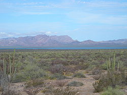
Sonora's natural geography is divided into three parts: the Sierra Madre Occidental
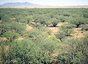
in the east of the state; plains and rolling hills in the center; and the coast on the Gulf of California. It is primarily arid or semi-arid deserts and grasslands, with only the highest elevations having sufficient rainfall to support other types of vegetation.
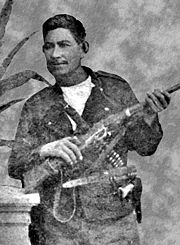
Sorona is home to eight indigenous peoples, including the Mayo
, the Yaqui and the Seri. It has been economically important for its agriculture, livestock (especially beef) and mining since the colonial period, and for its status as a border state since the Mexican–American War
. After the Gadsden Purchase
, Sorona lost more than a quarter of its territory. From the 20th century to the present, industry, tourism and agribusiness
have dominated the economy, attracting migration from other parts of Mexico.
on the day of Nuestra Señora del Rosario ("Our Lady of the Rosary
") which falls on with the pronunciation possibly changing owing to the fact that none of the indigenous languages of the area have the ñ sound. Another theory states that Álvar Núñez Cabeza de Vaca
and the crew of the ship Florida, wrecked off the Sonora coast, were forced to cross the arid state from north to south, carrying an image of Nuestra Señora de las Angustias ("Our Lady of Anguish") on a cloth. They encountered the Opata, who could not pronounce "Señora", instead saying Senora or Sonora. A third theory, written by Father Cristóbal de Cañas in 1730, states that the name comes from the word for a natural water well, sonot, which the Spaniards eventually modified to "Sonora". It is not known if any of these theories are even partly correct. The first record of the name Sonora comes from explorer Francisco Vásquez de Coronado
, who passed through the state in 1540 and called part of the area the Valle de La Sonora. Francisco de Ibarra
also traveled through the area in 1567 and referred to the Valles of Señora.
. The first humans were nomadic hunter gatherers who used tools made from stones, seashells wood. During much of the prehistoric period, the environmental conditions were less severe than they are today, with similar but more dense vegetation spread over a wider area.
Agriculture first appeared around and in the river valleys. Remains of ceramics have been found dating from with diversification from 800 and Between 1100 and 1350, the region had socially-complex small villages with well-developed trade networks. The lowland central coast, however, seems never truly to have adopted agriculture. Because Sonora and much of the northwest does not share many of the cultural traits of that area it is not considered to be part of Mesoamerica
. Though there is evidence of trade between the peoples of Sonora and Mesoamerica, Guasave in Sinaloa
is the most north-westerly point considered to be Mesoamerican.
Three archaeological cultures developed in the low flat areas of the state near the coast: the Trincheras tradition, the Huatabampo tradition and the Central Coast tradition. The Trincheras tradition is dated to between 750 and 1450 CE and mostly known from sites in the Altar, Magdalena and Concepción valleys, but its range extended from the Gulf of California into northern Sonora. The tradition is named after trenches found in a number of sites, the best known of which is the Cerro de Trincheras. The Huatabampo tradition is centered south of the Trincheras along the coast, with sites along extinct lagoons, estuaries and river valleys. This tradition has a distinctive ceramic complex. Huatabampo culture shows similarities with the Chametla to the south and the Hohokam
to the north. This probably ended around 1000 CE. Unlike the other two tradition, the Central Coast remained a hunter-gatherer culture, as the area lacks the resources for agriculture.
The higher elevations of the state were dominated by the Casas Grandes
and Río Sonora tradition. The Río Sonora culture is located in central Sonora from the border area to modern Sinaloa. A beginning date for this culture has not been determined but it probably disappeared by the early 1300s. The Casas Grandes tradition in Sonora was an extension of the Río Sonora tradition based in the modern state of Chihuahua, which exterted its influence down to parts of the Sonoran coast.
Climatic changes in the middle of the 15th century resulted in the increased desertification
of northwest Mexico in general. This is the probable cause for the drastic decrease in the number and size of settlements starting around this time. The peoples that remained in the area reverted to a less complex social organization and lifestyle. Whatever socially complex organization existed in Sonora before the Spaniards were long gone by the 16th century.
. Others state that Francisco Vázquez de Coronado founded a village on the edge of the Yaqui River in 1540 on his way north... Another source states that the first Spanish presence was not until 1614, by missionaries such as Pedro Méndez and Pérez de Rivas, working with the Mayo
. Unlike in central Mexico, there was no central social or economic centralization in the Sonora area, given the collapse of population centers in the 15th century. The five traditions of the past had broken down to a number of fractured ethnicities. There was no empire or other system for the Spaniards to co-opt for domination purposes. In addition, the Yaqui people resisted European intrusion on their lands, effectively keeping the Spaniards out of their area until the 1600s. While there was exploration of the area through the expeditions of the 16th century, significant permanent Spanish settlement did not become possible until the establishment of the mission system.
Jesuit priests began to work in Sonora in the 1610s in the lowlands near the coast. Originally, these missionaries worked out a peaceful compromise with the 30,000 Yaquis allowing for the establishment of more than fifty mission settlements in the Sonora river valleys. This broke down when the Jesuits opposed the native shamanic religious tradition. The Opata were more receptive to the missionaries and allied with them. After this, the Jesuits began to move into Pima
and Tohono O'odham
territories. Spanish exploration and missionary work was sufficient to consider the territory part of New Spain
. An agreement between General Pedro de Perea and the viceroy
of New Spain resulted in the general shaping of the province, initially called Nueva Andalucia in 1637, but renamed Sonora in 1648.
The most famous missionary of Sonora, as well as much of what is now the American Southwest
, was Eusebio Kino
. He arrived in Sonora in 1687 and started missionary work in the Pimería Alta area of Sonora and Arizona. He began his first mission at Cucurpe, then established churches and missions in other villages such as Los Remedios, Imuris, Magdalena, Cocóspera, San Ignacio, Tubutama and Caborca
. To develop an economy for the natives, Father Kino also taught them European farming techniques.
The initial attraction of Sonora for the Spaniards was its fertile farmlands along the river valleys and its position as part of a corridor linking the central Mexican highlands around Mexico City
up the Pacific coast and on into Arizona and points north. This corridor still exists in the form of Federal Highway 15
. After the establishment of the mission system, Spanish colonists followed. Indigenous response was a mixture of accommodation and violence, as different strategies were employed by different groups at different times. The sporadic violence, which would continue throughout the colonial period, resulted in the Spanish building presidio
s and other fortifications to protect missions and Spanish settlements. While the colonization process was not especially violent, the impact on the indigenous of the area was severe, as it almost completely disrupted their formerly very independent lives, forcing them to conform to an alien centralized system. One consequence of this was alcoholism among the native peoples.
In 1691, what are now the states of Sonora and Sinaloa were joined into an entity called the Provincias de Sonora, Ostimuri y Sinaloa. They would remain as such through the rest of the colonial period until 1823. At this time, there were about 1,300 Spanish settlers in the area. Colonization increased in the 18th century, especially from 1700 to 1767, when mineral deposits were discovered, especially in Álamos
. This led to the establishment of a number of royally controlled mining camps, forcing many natives off their agricultural lands. Loss of said lands along the Yaqui
and Mayo Rivers led to native uprisings during this time. A major Seri rebellion took place on the coast area in 1725–1726, but the largest uprising was by the Yaquis and Mayos from 1740 to 1742 with the goal of expelling the Spaniards. Part of the reason for the rebellion was that the Jesuits as well as the secular Spaniards were exploiting the indigenous. This rebellion destroyed the reputation of the Jesuit mission system. Another Seri rebellion occurred in 1748, with Pima and Tohono O’otham support and lasted into the 1750s. This kept the settlement situation in disarray. With population of the Mexican north roughly split half indigenous and half Spanish, about one quarter of the indigenous population lived in Sonora alone. In 1767, the king of Spain expelled the Jesuits from Spanish-controlled territories, ending the mission system.
which was started in 1810. However, Sonora was not directly involved in the war, as independence came by way of decree. One positive aspect of independence is that it allowed for economic development. The former province of Sonora, Ostimuri y Sinaloa, was divided in 1823 to form the states of Sonora and Sinaloa, with the Sonoran capital in Ures
. However, they were be reunited in 1824 and remained so until the 1830s, despite of the fact that Sonora was declared a state by the 1824 Constitution of Mexico
. Sonora became separate again in 1831, when it wrote its first state constitution, which put the capital in Hermosillo
. In 1832, the capital was moved to Arizpe
.
The struggles
between the Conservatives, who wanted a centralized government, and Liberals, who wanted a federalist system, affected the entire country during the 19th century. In 1835, a centralist government was instituted based on what were called the Bases Constitutionales ("Constitutional Bases"). They were followed by the Siete Leyes Constitutionales ("Seven Constitutional Laws"), which remained in effect until 1837. But in December of the same year, General José de Urrea
proclaimed in Arizpe the re-establishment of the Constitution of 1824, initially supported by then Governor Manuel Gándara. However, for the rest of the century, Gándara and succeeding governors would support a centralized government, leading to political instability in the state. In 1838, the capital was moved back to Ures.
The fertile lands of the Mayo and Yaquis continued to attract outsiders during the 19th century. These were now Mexicans rather than Spaniards, and later in the century it was be a major draw for North Americans. By the end of the 19th century, however, the area received large numbers of immigrants from: Europe
, especially from Germany
, Italy
and Russia
; Middle East
, mainly Lebanon
or Syria
; and even China
, who brought new forms of agriculture, mining, livestock, industrial processes, ironwork and textiles.
The Mexican–American War
resulted in only one major military confrontation between Mexican and U.S. forces, but its consequences were severe for the state. In October 1847, the warship USS Cyane
laid siege to Guaymas
bay, resulting in U.S. control of this part of the coast until 1848. When the war ended, Sonora lost 339,370 hectares of its territory to the U.S. through the Treaty of Guadalupe Hidalgo
.Additionally, the war ruined the state's economy. Sonora lost more territory in the 1850s, through the Gadsden Purchase
. Before the war, Sonora was the largest entity in Mexico, but as a result of the Gadsden Purchase the northernmost part of the state became part of the United States. The majority of the area is today's Arizona
south of the Gila River
and a part of the present day southwestern New Mexico
. The area's political vulnerability immediately after the war made it susceptible to buccaneers such as William Walker, Gaston de Raousset-Boulbon
and Henry Alexander Crabb who attacked Sonoran ports such as Guaymas and Caborca
. However, most attacks were repelled. The economy did not begin to recover from the war until the late 1850s, when Ignacio Pesqueira became governor and attracted foreign investment to the state, especially in the mining sector as well as worked to create markets abroad for agricultural products.
During the French intervention in Mexico
, Sonora was invaded by French troops as part of the effort to install Maximilian I
as a monarch in Mexico. The port of Guaymas was attacked by forces under Armando Castagny, forcing Mexican forces under Pesqueira and General Patoni to retreat north of the city. French troops attacked the Mexicans again at a place called La Pasión, again resulting in defeat for the Mexican resistance. The French were not defeated in the state until the Battle of Llanos de Ures in 1866 by Pesqueria, Jesús García Morales and Ángel Martínez. Shortly after this, the state's current constitution was written in 1871, and its capital was permanently moved to Hermosillo.
 During the regime of Porfirio Díaz
from the 1800s to the 1900s, major economic changes occurred. These changes promoted rapid economic growth, which had far-reaching social and political consequences. Sonora and the rest of the northern states rapidly increased in economic importance. Development of a rail system integrated the state's economy into the national, and also allowed greater federal control over all of Mexico's territory. After 1880, this rail system was extended north into the U.S., making it an important part of bi-national economic relations to this day. However, the changes also permitted foreigners and certain Mexicans to take over very large tracts of land in Mexico. In Sonora, Guillermo Andrade controlled 1570000 ha (15,700 km²; 6,061.8 sq mi), Manuel Peniche and American William Cornell Green about 500000 ha (5,000 km²; 1,930.5 sq mi). Foreign industry owners also tended to bring in Asian and European workers. Chinese immigration
into Sonora would begin at this time, and the Chinese soon became an economic force as they built small business that spread wherever there was economic development.
The appropriation of land for both agriculture and mining placed renewed pressure on the Yaquis and other native peoples of Sonora. Previously, active resistance had given the Yaqui fairly autonomous control of a portion of the state, and kept their agricultural system along the Yaqui River. Encroachment on this land led to uprisings and guerilla warfare by the Yaquis after 1887. By 1895, the federal and state governments began to violently repress the Yaquis and began to forcefully relocate captured Yaquis to the plantations in Mexico’s tropical south, especially the henequen
plantations in the Yucatán Peninsula
. The Yaqui resistance continued into the 1900s, with the expulsions reaching a peak between 1904 and 1908, by which time about one quarter of this population had been deported. Still more were forced to flee into Arizona.
 The policies of the Díaz government not only caused resentment among the Yaquis, but also throughout the country. One of the preludes to the Mexican Revolution
was the 1906 Cananea miner's strike
. The approximately 2,000 strikers sought negotiations with American mine owner William Greene, but he refused to meet with them. The strike quickly turned violent when the miners tried to take control of the mine and gunfire was exchanged. Greene requested help from federal troops, but when it was obvious they could not arrive in time, he appealed to the governments of Arizona and Sonora to allow Arizona volunteers to assist him. This increased the scale of the violence. When Mexican federal troops arrived two day later, they put everything to a brutal end, with the suspected leaders of the strike executed. The heavy handed way in which Díaz had handled the strike made resentment against Diaz grow, with more strikes beginning in other areas.
In late 1910, the Mexican Revolution began in earnest, and Díaz was quickly deposed. The governor of Coahuila
, Venustiano Carranza
, sought refuge in Sonora, and became one of the principal political leaders during the rest of the war, with his main base of operations in Hermosillo. A number of the revolutionary leaders who joined Carranza in Sonora did not come from peasant backgrounds, but rather the lower middle class of hacienda-managers, shopkeepers, mill-workers, or schoolteachers, who opposed large-scale landowners and the Porfirian elite. After Díaz was deposed, Carranza competed for power against Álvaro Obregón
and others. The Yaquis joined with Álvaro Obregón’s forces after 1913.
By 1920, Carranza had become president of Mexico, but found himself opposed by Obregón and others. Carranza tried to suppress political opposition in Sonora, which led to the Plan of Agua Prieta
which was signed to formalize Obregón’s and his allies’ (primarily Abelardo L. Rodríguez
, Benjamín Hill
and Plutarco Elías Calles
) resistance to Carranza. This movement soon came to dominate the political situation, but it caused widespread political instability in doing so. Obregón would succeed in deposing Carranza and becoming the next president of Mexico. For the 1924 presidential elections, Obregón chose Plutarco Elias Calles to succeed him, who was also a revolutionary leader from Sonora. This effectively ended the war, but hostilities had again destroyed the Sonoran economy. From 1920 to the early 1930s, four Sonorans came to occupy the Mexican presidency Adolfo de la Huerta
, Obregón, Calles and Rodríguez.
The Chinese first arrived at Guaymas in the late 19th century and congregated there and in Hermosillo. Over the following decades, they moved into growing communities such as Magdalena
and Cananea
. Rather than working in the fields, most started their own small businesses, networking among other Chinese. These business spanned a wide range of industries from manufacturing to retail sales of just about every type of merchandise. The Chinese in Sonora has not only become successful shopkeepers, they eventually came to control local small businesses in many areas of the state. By 1910, the Chinese population in Sonora was 4,486 out of a total population of 265,383, making them the largest foreign presence in the state, with only North Americans a close second at 3,164. Almost none were female as there were only 82 Chinese females in the entire country at the time. The Chinese population reached its peak in 1919 with 6,078 people, again with almost no Chinese women.
Resentment against Chinese success began quickly, but Sinophobia
rose sharply during the Mexican Revolution as many Chinese prospered despite the war, and many attacks were targeted against them. The first organized anti-Chinese campaign in Sonora began in 1916 in Magdalena. A more serious campaign began in 1925, calling for their expulsion from the state. Mass expulsions were mostly carried out in Sonora and Sinaloa partly because of their large populations, but the Chinese, often with their Mexican wives and children, were deported from all over the country. Some were returned to China but many others were forced to enter the U.S. through the border with Sonora, even though Chinese exclusion laws were still in effect there. Sonoran governor Rodolfo Elias Calles was responsible for the expulsion of most Chinese-Mexican families into U.S. territory. Despite the diplomatic problems this caused, Elias Calles did not stop the expulsions until he himself was expelled from Sonora. However, by that time almost all of Sonora’s Chinese-Mexicans had disappeared. By the 1940 census, only 92 Chinese were still living in Sonora, with more than two-thirds of these having acquired Mexican citizenship. This had the unintended consequence of nearly collapsing the Sonoran economy.
The efforts at modernization and economic development begun in the Díaz period would continue through the Revolution and on through the rest of the 20th century. In the late 19th and early 20th century, the process of electrification greatly increased the demand for copper, which led to a boom in mining in Sonora and neighboring Arizona. Cananea grew very quickly from a village of 900 to a city of 20,000. It also led to a network of roads, railroads and other connections across the border. However, organized development of the state’s agriculture was put on hold because of the Revolution, the Great Depression
and other political upheavals.
In the 1930s, Sonora benefitted from a number of national policies aimed at developing the cities on the border with the U.S. and to build a number of dams to help develop agriculture and general water supply. Major agricultural reform was begun in the 1940s in the Mayo River area, when the delta was cleared of natural vegetation and made into farmland. Water for these farma was secure through the building of the Mocúzari Dam about 15 miles (24.1 km) from Navojoa
. When it was completed in 1951, there was a system of canals, wells and highways to support large scale agriculture for shipment to other places.
In the last half of the 20th century, the state's population has grown and foreign investment has increased due to its strategic location along the border and its port of Guaymas. More than 200 international and domestic enterprises moved into the state, allowing for the development of modern infrastructure such as highways, ports and airports, making the state one of the best connected in the country. A bridge was built over the Colorado River
to link Sonora with neighboring Baja California Norte
in 1964. One important sector of the economy has been industry, culminating in the Ford automotive plant in Hermosillo and a number of assembly plants called maquiladoras on the border with the U.S. One the fastest growing sectors of the economy has been tourism, now one the most important sectors of the economy, especially along the coast, with the number of visitors there increasing every year. This has led to a surge in hotel infrastructure, especially in Puerto Peñasco
.
For most of the 20th century, Mexico was dominated by the Institutional Revolutionary Party
(PRI). Discontent with this one-party system became prominent in the northern states of Mexico, including Sonora. As early as 1967, a competing party, the National Action Party
(PAN), won control of the city government of Sonora's capital, Hermosillo. PAN won important municipal victories in the state in 1983, which President de la Madrid
refused to officially recognize but was forced to let stand. PAN's growing strength by the 1980s forced the PRI to nominate candidates who were similar to PAN, successful business executives who favored economic liberalization over traditional Mexican statism, preferred in the north of the country. Institutional Revolutionary Party won the Sonoran gubernatorial race in 1985, but it was heavily contested with obvious problems of fraud. By the 1990s, PRI operatives caught manipulating election results were actually prosecuted by the Sonoran state attorney. This along with other events in the country would eventually lead to the end of the one party system when Vicente Fox
was elected president in 2000. PAN has since dominated most of the north of the country, but Sonora would not have its first PAN governor until 2009, which the election of Guillermo Padrés Elías
.
 Sonora's border with Arizona has received more attention since 2000, with the increase of illegal border crossings and drug smuggling, especially in rural areas such as around Naco
, which is one of the main routes into the U.S. Starting in the 1990s, increased border patrols and the construction of corrugated metal and chain link fences in California and Texas dramatically cut illegal border crossing in these two states. This forced illegal immigrants into the more dangerous desert areas of Arizona and New Mexico, which have mostly seen rises in illegal crossings since then. Many migrants now come to the Arizona border between Agua Prieta
and Nogales
, with Naco as one of the preferred routes for "coyotes" (also called "polleros" or "enganchadores") or smugglers who offer to take migrants across. There are migrant shelters and hotel in border towns which cater to those waiting to the chance to make the crossing into Arizona. Providing lodging for migrants is a growing business in Naco and other border towns, where the rate is between 200 and 300 pesos
per night per person. Many of these lodgings are filled with people who cannot cross the border. One example is the Hospedaje Santa María, which is a run-down, two-story building.
Forty-five percent of the deaths of migrants occur on the Arizona side of the border. According to Arizonan authorities, 2010 was a record year for deaths in Arizona for people crossing illegally from Sonora, with the bodies of 252 crossers found in the deserts between the New Mexico
and California borders. This broke the previous record of 234 in 2007, with nearly 2,000 found in this area since 2001. However, Mexican officials state that the figures are higher, with over four hundred dying in Arizona deserts in 2005 alone. In 2006, Mexican officials began to distribute maps of Arizona to Mexicans gathered in Sonoran border town with the intention of crossing illegally. The Mexican government stated the reason for the maps was to help Mexican avoid dangerous areas that have caused deaths from the desert's heat.
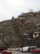
Migration and drug smuggling problem has affected most border towns. Many people make a living by catering migrants or working as "coyote" guides. Mexicans and others either looking to cross and those recently deported crowd these the border area. Some returned home, but many others decide to stay on the Sonoran border, working to earn money for another attempt. These workers put a strain on insufficient municipal medical services. The walls, which have shut down much of the illegal crossings into Texas and California, have also been built on parts of the Arizona border, especially between towns such as the two Nacos and the two Nogales'. The wall in Naco is four meters high and made of steel. It currently extends 7.4 kilometres (4.6 mi), but there are plans to extend it another 40 kilometres (24.9 mi). Security here was further tightened after the 2001 September 11 attacks. The U.S. Border Patrol
credits the wall and better surveillance technology with cutting the number of captured border crossers near Naco by half in 2006. People on both sides of the wall have mixed feelings about it.
Violence connected to drug smuggling on the border and in Mexico in general has caused problems with tourism, an important segment of the entire country. Federal troops have been stationed here due to the violence, which has the population divided. While the security they can provide is welcomed, there is concern about the violation of human rights. In 2005, the state began advertising campaigns to reassure Arizonans that it is safe to cross the border.
 Sonora is located in northwest Mexico. It has a territory of 184934 square kilometres (71,403.4 sq mi) and is the second largest state of the country. It borders the states of Sinaloa, Chihuahua, and Baja California Norte, with the U.S. to its north and the Gulf of California to its west. Its border with the U.S. is 588 kilometres (365.4 mi) long. The state is divided into 21 political districts with 72 municipalities
. It is also divided into five hydrolic regions – Río Colorado, Sonora Norte, Sonora Sur, Sinaloa, Cuencas Cerradas del Norte.
The state's geography is divided into three regions created by the rise of the Sierra Madre Occidental
mountains and the separation of the Baja California peninsula
, with all three running roughly north-south. The mountains dominate eastern Sonora, while the center is dominated by plains and rolling hills, which then extend west to the coast on the Gulf of California.
 The center plains and coastline were both created by the tearing away of the Baja California peninsula between ten and twelve million years ago. These plains are between 50 kilometres (31.1 mi) and 120 kilometres (74.6 mi) wide, wedged between the Sierra Madre and the Gulf of California, which began to form between 5.5 and 6 million years ago. Climate patterns bring moisture east from the Pacific Ocean, forming rivers and streams that cross the plains area and empty in to the gulf. These rivers have brought down sediment from the volcanic rock of the Sierra Madre and eventually buried most of the mountains and hills of the center of the state, smoothing them into plains. These soils are rich in clays and thousands of feet thick in places, making this region very fertile, only lacking water.
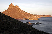
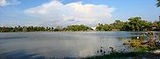
The state as 816 kilometres (507 mi) of coastline, all of which faces the Gulf of California, with its relatively shallow and very calm waters. There are beaches along most of this coastline, some of which with fine, white sand.The best known of these are San Carlos, Puerto Peñasco
and Bahía Kino
. San Carlos, with its Los Algodones Beach is one of the most visited areas on the Sonoran coast. Los Algodones ("The Cottons") is name for its dunes of white sand, which can be compared to cotton balls. San Carlos has a large variety of sea life off its shores, making it popular for sports fishing and scuba diving. A number of Yaquis, Seris and Guaymas
on and around the Tetakawi Hill, making a living from fishing.
 Puerto Peñasco is located in the extreme northwest of the state in the Upper Gulf somewhat near where the Colorado River empties. It contains 110 kilometres (68.4 mi) of beaches on calm seas, located in the Altar Desert near El Pinacate biosphere reserve, some of the driest climates in Mexico. Since the 1990s, it has experienced large-scale development along its 110 kilometres (68.4 mi) of beaches, which have calm seas. It is located extreme northwest of the state. The area has experience a building boom since the 2000s.
Bahía Kino is located near San Carlos, with a dock located in the commuty of Kino Viejo. This bay's beaches have white sand, with warm calm waters off of them. For this reason, Bahía Viejo calls itself la perla del Mar de Cortés ("the pearl of the Gulf of California"). The area is popular for scuba diving and sports fishing as its waters are filled with various species of multicolored fish, small invertebrates, large crustaceans, manta rays, sponges and turtles. On the neighboring islands, sea lion
s can be seen. Off this coast is the Isla Tiburón, Mexico’s largest island and a nature reserve with wild sheep and deer. There are indigenous communities here, especially at Punta Chueca
, which still practice hunting, fishing and collecting natural resources, as well as selling crafts to tourists.
Lesser known beaches include El Desemboque
, El Himalaya and Huatabampito. El Desemboque is a small Seri village with beaches located 370 kilometres (229.9 mi) northwest of Hermosillo
, just south of Puerto Libertad
. Activities in the area include scuba diving and swimming in isolated and relatively undeveloped beaches. The current name is from Spanish (disembarkation point), but the Seri name for the area means "where there are clams." El Himalaya Beach is located forty km from Guaymas
. It is a semi virgin beach surrouned by calm waters, mountains, and unusual species of flora and fauna and cave paintings. The area is filled with large stone yellow-red rock formations that were created by a volcanic eruption. Huatabampito is an area of beaches in the south of the state. The beaches have delicate dune of fine sand and the waters are clear with a green-blue color. Each year, whales arrive to this area to reproduce in the warm waters. This is the main attraction, bringing visitors from Mexico and abroad.
 Habitats and vegetation vary greatly depending on elevation and rainfall. An estimated 2230000 ha (22,300 km²; 8,610.1 sq mi) of Sonora is in arid grasslands; 1200000 ha (12,000 km²; 4,633.2 sq mi) are covered in forests, 301859 ha (3,018.6 km²; 1,165.5 sq mi) in rainforest and 1088541 ha (10,885.4 km²; 4,202.9 sq mi) in farmland. Seventy percent of the territory, or 13500000 ha (135,000 km²; 52,123.8 sq mi), is covered in desert vegetation or arid grasslands. The Yécora
municipality in eastern Sonora has one of the highest grass diversities in Mexico. There are eight types of desert vegetation, seven of which are native to the Sonora Desert and one in the area that transitions to the Chihuahua Desert. Most are scrubs or small bushes, which generally do not reach over 4 metres (13.1 ft) in height, most of the rest are cactae, with some mangroves and other halophile
plants. Many plants are rainfall sensitive, with most trees and shrubs growing leaves and flowers just before or during the rainy season, then drop their leaves afterwards. However, there are plants in flower at one time or another throughout the year. Coastal plants receive less water stress due to lower evaporation rates, and substantial moisture from dew, especially in the cooler months.
 Most forests are located in the northeast of the state, covering about 6.4% of the state. This is the area with the coolest temperatures. Deforestation has been a significant problem, especially after 1980, because the rate of cutting trees has increased. In central Sonora, the area covered by Madrean evergreen woodland and Sonoran Desert scrub decreased 28% and 31%, respectively, between 1973 and 1992 (ValdezZamudio et al. 2000). During this same period, For example, much of the forests of mesquite
trees in the lower elevations of the state have disappeared because of the demand for local fuels and the market for mesquite charcoal in Mexico and the U.S.
Most of northern Mexico suffers from one of the world’s highest rates of desertification
due to land degradation in arid and semi arid areas, with the loss of biological and/or economic productivity, but the process is most severe Sonora as neighboring Sinaloa
. Land degradation occurs because of clearing land for agriculture, the planting of non-native buffelgrass for grazing, the cutting of forests, overgrazing of natural vegetation and soil salinization from irrigation. A study by A study by Balling in 1998 showed higher soil and air temperatures in areas that have been overgrazed, deforested and otherwised cleared land, likely due to the lack of shading vegetation, which leads to higher soil evaporation and desert conditions. Studies have also indicated that warming trends are higher in Sonora than in neighboring Arizona, into which the Sonora Desert also extends.
The state contains 139 species and subspecies of native mammals, with the most important being white tailed deer, mule deer
, wild sheep, bats, hares, squirrels, moles
, beaver
s, coyote
s, wolves, foxes, jaguar
s, and mountain lions. Amphibians and reptiles include frogs and toads, desert tortoise
s, chameleon
s, gila monster
s, rattlesnake
s and other types of snakes. The number of bird species native to the state is not known, but major species include roadrunner
s, quail
, turkeys, buzzard
s and doves.
, the detachment of Baja California, the development of the Gulf of California and the Subartic California current drastically reduced moisture coming into Sonora leading to severe regional aridity in both this state and neighboring Baja California. This created xeric communities and the development of species endemic only to this region.
The climate is desert (BWh group; see table 1.1) in the northwest, and dry (Bsh group) elsewhere. There are four major climate regions in the state: dry desert (BW), arid lands (BS), semi moist lands (AC) and temperate zones (Cw). Ninety percent of the state has desert or arid conditions. The other two climates are restricted to the areas of the state with the highest altitude such as the Yécora area, the mountains north of Cananea
and a strip along the southeast of the state on the Chihuahua border.
Average high temperatures range from 12.7C in Yécora to 35C in Tesia, municipality of Navojoa
. Average low temperatures range from 5.9C in Yécora to 35.2 in Orégano, municipality of Hermosillo
. In the winter, cold air masses from the north reach the state, and can produce below freezing temperatures and high winds at night in the higher elevations, but the temperature can then jump back up to over 20C during the day. Freezing temperatures in the lowlands almost never occur. In February 2011, the Mexican government recorded a low in Yécora of −12C.
Precipitation is seasonal and most occurs in the higher elevations. In hot and arid or semi arid lands, evaporation vastly exceeds precipitation. Mexico’s most arid area, the Altar Desert is located in this state. The east of the state is dominated by the Sierra Madre Occidental, which has less extreme temperatures and relatively more rainfall due to altitude. Most moisture comes in from the Pacific Ocean and the tropics, which is pushed against the Sierra Madre. This cools the air masses, leading to rain and occasionally snow in the higher elevations. While most of the rain falls in the mountainous areas, much of this water finds its way back to the western coastal plains in the form of rivers and streams that empty into the Gulf of California and fill underground aquifer
s. Most of the year’s precipitation falls during the rainy season, which is locally called “las aguas” (the waters). These last from July to mid September, when monsoon
winds bring moist air from southerly tropical waters. Most of this is from the Pacific Ocean west of Central America
but can also come from Gulf of Mexico
as well. This moister flow results in nearly daily afternoon thunderstorms. After the las aguas, there may be additional moisture brought in by hurricanes, which generally move west along the Pacific coast of Mexico and occasionally come inland, especially in southern Sonora. However, these storms tend to drop large quantities of rain in a short time, causing flooding and destruction.
In the winter, from November to February, there are light rains called equipatas ("horse hoofs", named after the sound the rain makes). These rains come in from the north from the southern extensions of frontal storms that originate in the northern Pacific Ocean. These end by March or April when the fronts are no longer strong enough to reach this far south. They end even earlier in the extreme south of the state as the storm systems retreat, with the dry season lasting eight or nine months in this part of the state. In the north these rains support a wide variety of spring annuals and wildflowers, but the water they supply in the south of the state is still important to help replenish wells.
 With the exception of the Colorado River
, river and aquifer systems in Sonora are a result of rains from incoming clouds squeezed against the Sierra Madre Occidental. This water runs down the west side of the mountains along the canyons and valleys towards the plains and coast and into the Gulf of California
, Sonora has seven major rivers – the Colorado River, the Concepción River
, the San Ignacio River, the Sonora River
, the Mátepe River, the Yaqui River
and the Mayo River. Dams, such as Alvaro Obregon
, Adolfo Ruiz Cortines, Plutarco Elias Calles, Abelardo Rodriguez and Lazaro Cardenas, have been built along some of these rivers, at least two of them where natural lakes existed. Some of the dams formed large deltas, such as that of the Mayo River. The largest aquifers are mostly found between Hermosillo and coast, the Guaymas Valley and the area around Caborca
. Most of these are having problems due to overpumping for agricultural irrigation.
is located between Puerto Peñasco and the U.S. border in the Altar Desert. The reserve consists of an area with a series of gigantic dormant volcanic craters, which are covered with flora and fauna. It is frequently visited by foreign tourists, researchers and photographers. The reserve has a site museum, which displays the area history from its formation to the present. The craters are named Badillo, Molina or El Trébol, Cerro Colorado, Volcan Grande, Caravajales and the largest, Mc Dougal.
The Cañón las Barajitas ("Barajitas Canyon") is a protected natural area which consists of three different ecosystems, located 31 kilometres (19.3 mi) north of San Carlos. It contains a kilometer of beaches and a canyon which has two distinct microclimates, one arid and desert-like and the other subtropical. The area was a wide variety of fauna including whales, dolphins and manta ray
s that can be seen off the coast depending on the season. Activities for visitors include kayaking
, paddleboats, scuba diving
and fishing. There are also caves as well as a solor observatory.
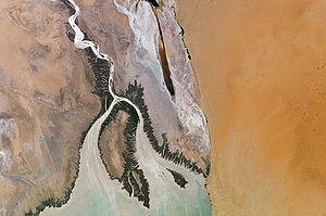
The Alto Golfo y Delta ("Upper Gulf and Delta") biosphere reserve encompasses is in the northwest of Sonora and northeast of Baja California Norte at the northernmost part of the Gulf of California and the delta of the Colorado River. The area is home to a very large number of marine species. There are also rocky beaches along with those with fine sand. Some of these are home to groups of seals and sea lions. The reserve was created in 1993 and encompasses an area of 934,756 hectares. On land, there are arid scrubbrush, coastal dunes and an estuary
. It extends into the far upper part of the Gulf of California.
The Bahía e islas de San Jorge ("Bay and Islands of San Jorge"), covering 130 square kilometres (50.2 sq mi), are located on Sonora’s northern coast between Caborca and Puerto Peñasco. The islands were first made a federal reserve in 1978 due to its important to migratory birds. They are especially important to species such as the Sterna antillarum, colonies of Sula leucogaster, Myotis vivesi
and Zalophus californianus. The islands are large rocks and are white from guano
. The beaches extend for ten km and end at the bay of San Jorge on the south end. The area is home to sea lions and a type of bat that fishes. There are sand dunes with arid zone vegetation as well as a small estuary. The climate is very arid and semi hot with an average temperature of between 18 and 22 °C (64.4 and 71.6 °F).
The Isla Tiburón is an ecological resereve with about 300 species of plants with desert and marine wildlife. The island used to be inhabited by the Seris and they still consider it as their territory.
The La Mesa el Campanero-Arroyo El Reparo reserve is found in the municipality of Yécora. It is a mesa with mountains which cover 43000 ha (430 km²; 166 sq mi), containing pine and tropical forests, rivers, arroyo
s, rock formations and dirt roads. Due to its altitude of between 700 and 2100 masl, its temperatures are temperate for the state. It is part of the Sierra Madre Occidential bio region and in the upper basins of the Yaqui and Mayo rivers.
, through an area of grasslands and oak mountain areas to the Sonoran Desert
west of Nogales
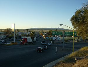
. The area gets drier from here west and the last third of the border is generally uninhabited. There are six official border crossings. From east to west these at Agua Prieta
, Naco
, Nogales, Sasabe, Sonoyta and San Luis Río Colorado
. In populated areas, much of the border is marked by corregated metal walls, but most of the rest is marked by barbed wire fence and border monuments.
Like others in the world, the border is a culture onto itself, not 100% belonging to either country culturally. Interaction between the peoples on both sides is a part of both the culture and the economy. In the 1980s, an international volleyball
game was regularly held near Naco, with the chain link border fence serving as the net. Much of Arizona and Sonora share a cuisine based on the wheat, cheese and beef that was introduced to the region by the Spaniards, with wheat tortilla
s being especially large on both sides of the border. This diet is reinforced by the vaquero/cowboy tradition which continues in both states. The six border crossings are essential to the existence and extent of the communities that surround them, as most of them function as ports for the passage of goods between the two countries. People regularly shop and work on the other side, taking advantage of opportunities there. The economic opportunities of the border are not equal on both sides. Most of the population along this border lives on the Sonoran side, many of which have moved here for the opportunities created by the maquiladoras and other businesses. These are lacking on the Arizona side.
The border has separated the region’s indigenous populations, such as the Tohono O’odham the Yaquis and the Pima
s. While members of the Tohono O’odham have special border crossing privileges, these have become endangered as Mexican farmer encroach on tribal lands in Sonora, which a vulnerable to drug smugglers. Yaquis in Arizona travel south to the Yaqui River
area for festival, especially Holy Week, and Yaquis travel north to Arizona for cultural reasons as well. When Father Kino arrived in this area, he named much of it the Pimería Alta, as Pima territory extends from the highlands of eastern Sonora up towards Tucson.
Authorities on each side work to keep out from the other that which is undesirable. For the U.S., this mostly involves drugs and illegal immigrants. For Mexico, this mostly involves struggling against the importation of untaxed goods, especially automobiles. Smuggling people and drugs into the U.S. is big business in Mexico, but while it affects everyone living on the border, it is generally not seen, except for occasional newspaper headlines, occasional violent crime and religious articles geared to those in the trade. Illegal crossings taking place through tunnels, hidden cars and trucks or most commonly, simply passing through a gap in the fence, especially in the more remote areas. In 1990, a tunnel linking two warehouses in Agua Prieta and Douglas, AZ was discovered. It was sophisticated with hydraulic equipment and means to move large quantities of goods. At least three corrido
s have been written about this tunnel.
has led to steady population growth. However, this population growth has been concentrated on the arid coastline due to the dominant agriculture and fishing industries. Eight five percent of Sonora’s population growth since 1970 has been in this area. Another area where there have been gains are municipalities with industry, such as in Hermosillo and along the U.S. border. However, those municipalities with none of these economic advantages do not see population growth and some see population decreases. Despite population growth, Sonora is still one of the least densely populated states in the country. About 90% of the state’s population is Catholic, with about 5% belonging to Evangelical or Protestant groups and over 7% professing some other faith.
, the Yaquis and the Seris; however there are a number of other groups which have maintained much of their way of life in territory in which they have live in for centuries. There were at least nine tribes, eight of which remain today. Seven are indigenous to Sonora, with one migrating to the state over a century ago from the U.S. These cultures generally hold in reverence the deserts, mountains, riverbeds and Gulf of California with which they have contact. Many of these beliefs have been adapted to Catholicism. There are efforts to preserve indigenous languages, but with groups of diminished size, this has been a challenge. As of 2000, there were 55,609 people, or 2.85% of the population, who spoke an indigenous language in the state. The indigenous population is concentrated in fourteen municipalities, which are home to 91% of the total indigenous population of the state. The municipalities with the greatest presence include Etchojoa
with 19% of the municipal population, Guaymas
with 8.34%, Huatabampo
with 11.8%, Navojoa
with 5.92%, Hermosillo
with 1.1%, Cajeme
with 1%, Bácum
with 9.26%, Benito Juárez
with 5.2%, San Ignacio Río Muerto
with 7.4%, Nogales
with 1.2%, Álamos
with 3.9%, San Miguel de Horcasitas
with 13.7%, Yécora
with 6.8% and San Luis Río Colorado
with 5.1%.
The Mayos
are the most numerous indigenous ethnic group in the state with more than 75,000 who have maintained their language and traditions. These people, who call themselves Yoreme, are descended from ancient Huatabampo culture. They are concentrated along the Mayo River. Most are found in the municipalities of Álamos, Quiriego
and others in the south of the state, as well as in some parts of the coast near the Isla Tiburón. There is also a notable community in the northwest of Sonora. Their religion is a mix of Catholicism and traditional beliefs, which they assimilated along with European farming and livestock knowledge. Mayo houses often have a cross made of ironwood
to protect against evil. Ethnically pure Mayos tend to segregate themselves from mestizos and other ethnicities. The Mayos make their living from subsistence farming, working on larger farms and combing wild area for herbs, fruits and other resources. They also work making crafts in wood making utensils and decorative items.
The Yaquis are the indigenous group mostly closely associated with the state of Sonora. These people are second most numerous in the state with about 33,000 members traditionally located along the Yaqui River. They are found principally in the communities of Pótam, Huíviris, Torim, Cocorit
, Bácum
, Vícam
, Rahúm and Belem, which have semi autonomous government. The Yaqui have been able to maintain most of their traditions including ancestor worship, original language, and many of their traditional rites and dances, with the Deer Dance the best known among outsiders. The Yaquis call themselves and the Mayos the “Yoreme” or "Yoeme". The Yaqui and Mayo languages are mutually intelligible, and the two peoples are believed to have been united until relatively recently. One of the Yaqui religious celebrations which is best known among outsiders is Holy Week
, along with rituals associated with Lent
and Day of the Dead
. As they consider the soul to be immortal, funerals are not a somber occasion but rather celebrations with banquets and music. The preservation of history is important to the Yaqui, especially the struggles they have had to maintain their independence.
The Seris call themselves the Comcáac, which means “the people” in the Seri language
. The name Seri comes from the Opata language
and means “men of sand.” There are about 650 Seri people today. They are well known among outsiders in the state because of their culture and the crafts they produce in ironwood. For centuries they have inhabited the central coast of the state, especially in Punta Chueca
, El Desemboque
and Kino Viejo
as well as a number of islands in the Gulf of California in and around the Isla Tiburón. Generally, the Seris are the tallest of the indigenous peoples of the region, and the first Spaniards to encounter them described them as "giants." Their traditional diet almost entirely consisted of hunted animals and fish. However, this diet changed after the arrival of the Spaniards, when the use of firearms led to the extinction of many food animals. The Seris' traditional beliefs are based on the animals in their environment, especially the pelican
and the turtle, with the sun and moon playing important roles as well. Rituals are now based on Catholicism, especially those related to birth, puberty and death, but they include traditional chants about the power of the sea, the shark and great deeds of the past. They are also known for the use of face paint during rituals which is applied in lines and dots of various colors.
The Tohono O’odham, still referred to as the Pápago by Spanish speakers, have inhabited the most arid areas of the state, and are mostly found in Caborca
, Puerto Peñasco
, Sáric
, Altar
and Plutarco Elías Calles
in the north of the state. However, most people of this ethnicity now live in neighboring Arizona. The Tohono O’odham have as a principle deity the “Older Brother,” who dominates the forces of nature. Among their most important rituals is one called the Vikita, which occurs in July, with dances and song to encourage rainfall during the area’s short rainy season. In July, during the full moon, a dance called the Cu-cu is performed, which is to ask for favors from Mother Nature
so that there will be no drought and the later harvests will be abundant. The dance is performed during a large festival with brings together not only the Tohono O’odham from Sonora, but from Arizona and California as well. The feast day of Francis of Assisi
is also important. Many of these people are known as skilled carpenters, making furniture as well as delicate figures of wood. There are also craftspeople who make ceramics and baskets, especially a type of basket called a “corita.”.
The Opatas are location in a number of communities in the center and northwest of the state, but have been disappearing as a distinct ethnicity. This group has lost its traditional rituals, and the language died out in the 1950s. The name means “hostile people” and was given to them by the Pima
s, as the Opatas were generally in conflict with their neighbors. They were especially hostile to the Tohono O’odham, who they depreciatingly refer to as the Papawi O’otham, or “bean people.” Today’s Opatas have completely adopted the Catholic religion with Isidore the Laboror as the ethnicity’s patron saint.
The Pima
s occupy the mountains of the Sierra Madre Occidental
in eastern Sonora and western Chihuahua state. The Pimas call themselves the O’ob, which means "the people." The name Pima was given to them by the Spaniards because the word pima would be said in response to most questions asked to them in Spanish. This word roughly means “I don’t know” or “I don’t understand.” The traditional territory of this ethnicity is known as the Pimería, and it is divided into two regions: the Pimería Alta and the Pimería Baja. The principle Pima community in Sonora is in Maycoba, with other communities in Yécora
and its vicinity as well as the community of San Diego, where there is a center selling Pima handcrafts. Pima religion is a mix of traditional beliefs and Catholicism. One of the most important celebrations is the feast of Francis of Assisi, who has been adopted as the patron saint of the Pima. Another important festival is called the Yúmare, which has a variable date with the purpose of asking for an abundant harvest, especially corn. Festivals generally last four days and consist of chants and dances such as the Pascola, accompanies by a fermented corn drink called tesguino
.
The Guarijíos are one of the least understood groups in the state, and are mostly restricted to an area called the Mesa del Matapaco in the southeast. The Guarijíos are related to the Tarahumara
s and the Cáhita
s. This was the first group to be encountered by the Jesuits in 1620. Initially, they lived in the area around what is now Álamos, but when the Spaniards arrived, they were dispossessed of their lands. They also did not intermarry with the newcomers, isolating themselves. For this reason, people of this group have very distinct facial features, and have keep their traditions almost completely intact. They remain isolated but are known for their handcrafts. In the 1970s, there was oppression of this group, which was not formally recognized until 1976. In this year, they were granted an ejido
.
The Cocopah is the smallest native indigenous group to Sonora with about 170 members, who live mostly in San Luis Río Colorado
, along the U.S. border, in addition to nearby communities in Arizona
and Baja California
. Their own name for themselves, Kuapak, means “which comes” and possibly refers to the frequent changes in the course of the Colorado River
. Traditional native dress is in disuse. It is characterized by the use of feathers and necklaces made of bones, and include nose rings and earrings with colorful belts for the men. The women used to wear skirts made of feathers. They still practice a number of traditional rituals such as cremation upon death so that the soul can pass on to the afterlife without the body encumbering it. Another traditional practice is the use of tattoo
s.
The Kickapoos are not native to Sonora, but migrated here from the U.S. over a century ago. Today, they are found in the communities of El Nacimiento in the state of Coahuila
, Tamichopa in the municipality of Bacerac
, as well as on several different reservations in the U.S. However, the Kickapoo community in Sonora is in danger of disappearing. In the 1980s, there were attempts to gather these disparate groups into one community. Eighty members remain in Sonora and they have lost their ancestral language, which was part of the Algonquin family
, with the last speaker dying in 1996, although the language is still widely spoken in other Kickapoo communities, especially in Coahuila. The Kickapoo community in Sonora has also lost much of their traditional culture.
 Despite a rough terrain and a harsh climate, Sonora, like the rest of the northern Mexico, is rich in mineral resources. This has led to a history of self reliance, and many see themselves as the heirs to a pioneering tradition. A large part of this is linked to the vaquero or cowboy tradition, as much of the state’s economy has traditionally been linked to livestock. Sonorans and other norteños (northerners) have a reputation for being hard working and frugal, and being more individualistic and straightforward than other Mexicans. Although most people in the state are employed in industry and tourism, the trappings of the cowboy, jeans, cowboy hats and pickup trucks, are still very popular.
In 2000, the gross domestic product
(GDP) of the state was 40,457 million pesos, accounting for 2.74% of the country's total. In 2008, Moody’s Investor’s Service
gave the state a A1.mx (Mexico) and Ba1 (global) ratings, based mostly on its strong economic base. The state has a highly skilled labor force, and strong ties to the U.S. economy, mostly due to its shared border with Arizona. This links affects various sectors of the state’s economy. Sonora is one of Mexico’s wealthier states with the GDP per capita about 15% higher than average, and GDP growth generally outpaces the rest of the country, with a growth of 8.4% in 2006 as compared to the national average of 4.8%. The economic success of the state, especially its industrial and agricultural sectors, as well as the border, have attracted large numbers of migrants to the state, from the central and southern parts of Mexico.
, chickpeas, grapes, alfalfa
, oranges and more. In 2002, agricultural production included 1533310 tonnes (3,380,369,912.3 lb) of wheat, 172298 tonnes (379,852,068.5 lb) of potatoes, 297345 tonnes (655,533,513.5 lb) of wine grapes (both red and white), 231022 tonnes (509,316,327.3 lb) of alfalfa, 177430 tonnes (391,166,191.8 lb) of oranges and 155192 tonnes (342,139,793.9 lb) of watermelon. Sonora and Baja California Norte are Mexico's two largest wheat-producing states, with Sonora alone producing 40% of Mexico’s wheat.
There is some small scale farming done in the state, especially in the highlands areas, growing corn and other staples mostly for auto consumption, highly dependent on the rainy season in the late summer as there is no irrigation. If these rains fail, the area suffers. However, most of the agriculture continues to shift away from small farms producing for local markets to largescale commercial agro-industry. Many of the country’s largest agribusiness
farms are located in Sonora. This agricultural production is concentrated in the lowlands areas, with much of the production exported to the U.S. This includes non-traditional crops such as fruits, nuts and winter vegetables such as tomatoes, especially since NAFTA.
Irrigation is essential for reliable agriculture on the coastal lowlands of the state, and large scale irrigation infrastruction is needed for large scale production. After the Mexican Revolution
, the federal government took control of Sonora’s irrigation infrastructure and after World War II
, began extensive dam and reservoir construction. From the 1940s to the 1970s, advanced in agricultural techniques were pioneered by the International Maize and Wheat Improvement Center (CIMMYT) based in Ciudad Obregón
. This combined new varieties of wheat, with irrigation, fertilizers and pesticides to greatly increase production. Mexico went from a wheat importer in the 1940s to a wheat exporter in the 1960s.
However, such intensive agriculture in such an arid area has had a significant negative impact of water supplies. Eighty-eight percent of all water taken from above and below the surface is used for agriculture. One third of aquifer
s are overdrafted, especially in Caborca
, Guaymas
and the coast near Hermosillo
. There have been water disputes in the state, notablely between officials from Hermosillo and the relatively water-rich Ciudad Obregón. The overpumping has drastically lowered water tables and has increaseds soil salinity in many areas. In some areas, the tables have dropped by as much as one or two meters per year, making fresh water increasing unavailable and forcing the abandonment of croplands. For this reason, in the last quarter of the 20th century area under cultivation in Sonora dropped by more than 24%.
The state still maintains its traditional livestock industry, especially in beef cattle, which as a national reputation for quality. In 2001, the state produced 1,477,686 heads of cattle, 1,229,297 pigs, 38,933 sheep, 33,033 goats, 83,260 horses and 11,988,552 heads of domestic fowl. The availablily of relatively inexpensive semiarid land, along with proximity to U.S. markets, concentrates livestock production in Sonora and other northern states.
until the mid 20th century. Today, some of Mexico’s largest commercial fisheries are in the state. Sonora is one of Mexico’s leading fish producing states, with 70% of Mexico’s total coming from the Pacific coast, including the Gulf of California.
Much of the catch is shrimp and sardines, with about three quarters exported to the U.S. In 2002, the catch totaled 456,805 tons of seafood with a value of about 2,031 million pesos. In addition to what is caught at sea, there is active fish farming which raises mostly oysters and shrimp. Much of the commercial and sports fishing is essentially unregulated and has had a very pronounced impact on the Gulf of California, with commercially important species such as shrimp, grouper
s, snappers
, corvinas, yellowtail, billfish
es have been harvested well above sustainability. Two species which have been particularly hard hit are sharks and manta ray
s. In addition, shrimp trawling catches a large amount of non target species, which are discarded, and have destroyed large areas of the Gulf’s seafloor. All this has led to rapidly declining harvests.
s,” mostly situated along the border and int the capital of Hermosillo
. These are assembly plants run by mostly U.S. companies, which have certain duty and tax breaks. By the end of the 20th century, these enterprises had a large influence on the expansion and modernization of the border area, including Sonora. They not only introduced new sources of employment, their U.S. management styles have had influence on business in the state and the rest of the north. However, maquiladoras peaked in 2001, and now many U.S. companies are moving production facilities to China. The number of maquiladoras has declined, but the value of their output has increased as those that remain shift to higher value-added goods and automation. In addition, many of the plants abandoned by U.S. companies have been taken over by Mexican firms. Despite the decline of maquiladoras, exports from them have risen 40%.
In addition to livestock, mining is another traditional element of Sonora’s economy, beginning with a major find near the city of Álamos
. While the silver of that area has mostly been depleted, Sonora still plays a large part in Mexico’s standing as one of the top fifteen producers of minerals in the world, leading in silver, celestite
and bismuth
. Sonora is the leading producer of gold, copper, graphite
, molybdenum
, and wollastonite
. There are still deposits of silver in the Sierra Madre Occidental. Sonora also has one of the largest coal reserves in the country. The state has the largest mining surface in Mexico, and three of the country’s largest mines: La Caridad, Cananea and Mineria María. It is also home to North America’s oldest copper mine, located in Cananea. Grupo México
, with one of its principle mining operations in Cananea, is the world’s third-largest copper producer in the world. In 2002, mines produced 6,634.5 kilograms of gold, 153,834 kilograms of silver, five tons of lead, 267,171 tons of copper, three tons of zinc
, 18,961 tons of iron, 7,176 tons barium sulphate. However, annual production is heavily dependent on world market prices.
Mexico’s mining industry was mostly dominated by the Spaniards during the colonial period, and then by foreign enterprises after Independence
. In the 1960s and 1970s, the government forced out most foreign interests in Mexican mining, beginning with the increasing restriction of ownership in Mexican mining companies. These restrictions were relaxed starting in 1992, with the only restriction that the operating company be Mexican. Within three years of the change, more than seventy foreign companies, mostly U.S. and Canadian enterprises, opened offices in Hermosillo.
Major mining operations have had severe environmental impact, especially in the areas surrounding it, with Cananea as the primary example. Mining has been functioning here for over a century, with mining and smelter wastes polluting the San Pedro
and Sonora River
s near the mine, threatening both watersheds. Mining operations also destroy nearby forests due to the demand for building materials and fuel. Few old trees stand near the city of Cananea
and the town of San Javier
in central Sonora.
, Hermosillo
, Guaymas
and Puerto Peñasco
, with beach destinations preferred by most leisure travelers. One advantage that Sonora has is its proximity to the U.S., from which come most of the world’s travelers. In second place are tourists from Canada, many of which visit as part of cruises. U.S. tourists mostly visit Puerto Peñasco, San Carlos and Navajoa and prefer areas which are considered to be friendly to them, with no “anti-U.S.” sentiment. Most leisure visitors from the U.S. tend to be between 40 and 65 years of age, married or in a relationship, educated at the university level or higher with about thirty days of vacation time and primarily research travel options on the Internet. Most visit to relax and experience another culture. Most domestic visitors also use the Internet, with about half having a university education or higher and about half are married or with a partner. Most domestic visitors are on vacation with their families. The busiest domestic travel times are Holy Week
, summer and Christmas, with the overall busiest months being January, April, July, August and December.
In 2009, the state received 7,024,039 visitors, which added 20,635 million pesos to the economy. Most visitors are domesticspending an average of 742 pesos. Foreign visitors spend on average of 1,105 pesos. Most stay on average 3.3 nights. Just over half of toursts in the state arrive to their destinations by private automoble, followed by airplane and commercial bus.
During the 2000s, Sonora has increased its tourism infrastructure. In the last half of the 2000s, Sonora has increased its network of highways from 3600 kilometres (2,236.9 mi) to 4500 kilometres (2,796.2 mi), accounting for 6.7% of all highways in Mexico. It ranks second in four lane highways, surpassed only by Chihuahua. From 2003 to 2009 the number of hotels in the state has increased from 321 to 410 and the number of rooms from 13,226 to 15,806, over 20%. Most of these hotels and rooms are in Hermosillo (57 hotels/3232 rooms) followed by Puerto Peñasco (40/3158), Ciudad Obregón
(41/1671), Guaymas/San Carlos (28/1590), Nogales (24/1185), Navojoa (15/637) and Magdalena de Kino
(10/284). The cities of Hermosillo, Ciudad Obregón, Guaymas, Nogales, San Luis Río Colorado
, Puerto Peñasco, Bahía Kino
and Álamos
all have 5-star hotels. There are 2,577 restaurants in the state with 1288 in Hermosillo.
Hotel occupation went from 45% in 2003 to 57.7% in 2006 but dropped to 36% in 2009. The state’s tourism suffered in 2008 and 2009, mostly due to the economic downturn and the AHN1 influenza crisis, which brought hotel occupancy rates down about 30%.
Sonora’s major tourist attraction is its beaches, especially San Carlos, Puerto Peñasco, Bahía Kino and the Gulf of Santa Clara in San Luis Río Colorado. San Carlos has a large variety of sea life off its shores, making it popular for sports fishing and scuba diving. One of its main attractions is the Playa de los Algodones, called such because its sand dunes look like cotton balls. On one of hills behind it, there is a lookout point which allows for views of the area. A number of Yaquis, Seris and Guaimas on and around the Tetakawi Hill, making a living from fishing. Puerto Peñasco has recently experienced large scale development along its 110 kilometres (68.4 mi) of beaches, which have calm seas. It is located extreme northwest of the state. Some of the available activities include jet skiing, boating, sailing, sports fishing, scuba diving and snorkeling. It is located near El Pinacate biosphere reserve. There is also an aquarium called the Acuario de Cer-Mar, which is a research center open to the public. The aquarium has a number of species such as marine turtles, octopus, seahorse
s and many varieties of fish. Bahía Kino is named after the Jesuit missionary, who visited the area in the 17th century. In the 1930s, a group of fishermen established a village in what is now known as Kino Viejo. This bay’s beaches have white sand, with warm calm waters off of them. For this reason, Kino Viejo calls itself la perla del Mar de Cortés (the pearl of the Gulf of California). Available activities include horseback riding, scuba diving and sports fishing. The Isla Tiburón is 28 kilometres (17.4 mi) from Bahia Kino in the Gulf of California. It is the largest island of Mexico, measuring 50 by. It has been declared an ecological reserve to protect its flora and fauna, such as the wild rams and deer that live here.
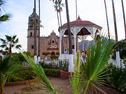
To enhance tourism in areas away from the primary beaches, the state of Sonora has set up several tourist routes for promotion as well as gained "Pueblo Mágico
" status for one of its smaller cities. The Ruta de las Missiones ("Missions Route") covers the principle stops of Jesuit missionary Eusebio Kino
, as the worked to establish the many religious institutions which are part of the state’s identity. These include the churches and missions in Caborca
, Pitiquito
, Oquitoa
, Átil
, Tubutama
, Imuris
, Cucurpe
and Magdalena
. In Magdalena, Father Kino remains are at the Padre Kino mausoleum. The Ruta del Río (River Route) follows a seriers of villages and towns along the Sonora River
. The state recommends this route in the fall when the chili pepper and peanut harvest occurs. The route includes the settlements of Ures
, Baviácora
, Aconchi
, San Felipe de Jesús, Huépac
, Banámichi
, Arizpe
, Bacoachi
and Cananea
. The Ruta de la Sierra Alta ("High Mountain Route") winds its way through the highlands of the Sierra Madre Occidental to see the significant peaks and towns of the area. Destinations include the towns Moctezuma
, Villa Hidalgo
, Huásabas
, Granados
, Huachinera
, Bavispe
, Nácori Chico
, Fronteras, Nacozari and Cumpas
, which have other attractions such as old hacienda
s, streams, forests and other forms of nature.
 The Ruta Sierra Mar ("Mountain Sea Route") is located in the south of the state among the towns around Álamos
, Navojoa
and Huatabampo
, which contain a large number of colonial era constructions. Attractions include the above mentioned cities along with the Adolfo Ruiz Cortínez, Tetajiosa and El Venadito dams and the town of Etchojoa
, which are surrounded by areas of desert and areas with tropical vegetation, around the Mayo River. The route begins in the mountains of Álamos and ends at the beaches of Huatabampo. Travelers can engage in a number of activities such as hunting, birdwatching, boating, kayaking and photography. The Ruta Yécora (Yécora Route) leaves from the capital of Hermosillo
and makes its way to the town of Yécora
, which is one of the highest communities in the mountains of the state. The Yécora area is known for its hunting and the area contains species which can only be found in this part of the state. From Hermosillo to Yécora, there are 280 kilometres (174 mi) of highway, which pass through a number of towns and natural vistas. These include La Colorado mine, San José de Pima on the Mátape River
, Tecoripa, San Javier which is surrounded by various hills, Tónichi, Ónavas, Tepoca, San Nicolás and the Mesa de Campanero forest.
Sonora has one Pueblo Mágico, which is Álamos, which was called Ostimuri by the native population. This town was founded in 1683, when a mineral deposit by the name of La Europea was discovered. The silver found here made it one of the richest towns in the region. The mines gave out in the 19th century and the town declined. Today, many of the old mansions and other buildings have been restored.
There are also a number of natural reserve areas that are open to visitors and promoted for tourism. These include El Pinacate in the Altar Desert and the Colorado Delta and Upper Gulf of California biosphere reserve. Both of these are near the major resort area of Puerto Peñasco and are some of the driest areas of Mexico.
and Agua Prieta
, but also in the smaller ones such as San Luis Río Colorado
and Naco
. On each side of the border, there is a fifteen km strip, which is designated as a commercial trade zone, where both Mexicans and U.S. citizens can enter with limited visa requirements. Many Arizonans travel and cross one of the crossings to eat and shop, mostly to experience something different from doing the same at home. Most spend only the day. The most popular of these border crossings is Nogales, which is just over an hour south from Tucson by highway. The main shopping street in Nogales is Avenida Obregón, which is crowded with pharmacies with lower prices than in the U.S., stores selling knock offs of designer names such as Louis Vuitton
, Cuban cigars, tequila
, cheaper cigarettes and Mexican handcrafts, including some of the best work from artisans from Puebla
, Guadalajara, Michoacán
and Oaxaca
. Although these stores cater mostly to Americans crossing the border, it is still possible to negotiate prices. Many of these communities on the Mexican side also have bars close to the port of entry, taking advantage of Mexico’s lower drinking age of 18.
The more important aspect of the border crossing is the commercial shipping that goes through, especially the Nogales port. There are two crossings at Nogales, one which connects the downtowns of the two cities, mostly for non-commercial traffic, and the Mariposa Port of Entry outside of the twin cities for trucks and commercial traffic. NAFTA increased cross border shipping. Counting traffic going both north and south, the Nogales port handles about three quarters of all border crossing between Sonora and Arizona. Nogales is a major port of entry for Mexican agricultural products heading to the U.S. and Canada. In 2005, 268,163 commercial trucks moved through the port, up from 242,435 in 2004, handling about 7.6% of all U.S.-Mexico truck traffic. Most of the merchandise that passes through Sonora on its way to the U.S. winds up in western states such as Arizona, Utah
, Nevada
, Idaho
and Montana
, as well as into Canada.
The volume of traffic, along with new security measures which have been put into place since 2001, create traffic jams of trucks and other vehicles, especially during the winter when demand for products grown in Mexico’s warm climates peaks. These jams can result in lines about eight miles long. For trucks moving into Sonora and south, inspection stations at Vícam
and near the Sinaloa border also cause delays. Delays in shipping causes more produce to rot before it can get to the consumer.
The last reason for the importance of the border is the maquiladora
industries, which have made areas such as Nogales grow significantly. Many of Sonora’s incoming migrants from other parts of Mexico come to work at these factories.
(palo fierro in Spanish), which is a very dense, almost black wood that sinks in water. This wood was often used in braziers in the past because it would burn for a very long time. This carving is the specialty of the Yaquis and the Seris. In order to carve this wood, it must be absolutely dry, a process that can take up to five years. If this is not done, the wood will take on an ochre
color, rather than its characteristic shiny near black. Objects made from this wood are almost always decorative in nature in a wide variety of shapes such as sahuaro and other cacti, eagles, turtles, dolphins and other flora and fauna of the state, along with crosses. The last is popular among indigenous groups as it is believed that such guard against the envy of others and other ills. Objects made of this wood are very much in demand on the international market, but indigenous craftsmen cannot compete with factory made pieces.
The higher elevations of the state and riverbanks contain large quantities of trees. Aconchi
is one of the villages of the state with a well established tradition of making furniture, with almost forty workshops. Many of these are in rustic or colonial style. In Arizpe
and Álamos
, they specialize in a type of chair made by bending and combining long flexible branches of willow and “guásima” (Guazuma ulmifolia
) In the town of Tubutama
, they make clocks of mesquite
wood.
Basketmaking is still widely practiced in the state, with hand made wares available in local markets such as in Bahía Kino
, Punta Chueca
and El Desemboque
. Those made near the ocean often have marine designs. Baskets made of reeds are made in Ures
along with hats. In Aconchi, palm fronds are used to make hats and baskets called guaris, used for food storage. In various locations, a basket variety called “caritas" are made in a globe shape and have a lid. This is a specialty of the Seris. These are typically made by women, with small baskets taking a month to make. Larger ones can take up to two years. Most coritas are bought by foreigners as the work needed to create them makes them expensive.
Leather goods such as belts, shoes, jackets, wallets and more in made in locations such as Nácori Chico
, Moctezuma
, Pitiquito
, Bacoachi
, Banámichi
, Huásbas, Arivechi
and Ures
. This craft is a result of the state’s history of cattle ranching. The mining industry gave rise to the working of metals, especially copper in Cananea
. Items include pots, pans, plates and decorative items. Álamos
is known for items made in brass and wrought iron.
Jewelry such as necklaces, bracelets and earrings are often made using materials from the sea such as various types of shells and spines from marine animals. This is a specialty in Puerto Peñasco
and of the Seris. The latter also use materials such as the tails of rattlesnake
s and animal teeth. Some of the Seris’ best work is located in a museum in Bahia Kino. There is also jewelry, especially necklaces made with various seeds, small twigs and river stones. In Oquitoa
, they made ceremonial crowns of glass in various colors. These are most often used to decorate the tombs of loved ones on Day of the Dead
. The Yaquis make unique belts using the paws of deer as well as elaborate masks for ceremonies. However, these people generally do not commercialize their wares, with the exception of cloth dolls in local markets.
, novelist Gerardo Cornejo Murrieta
, writer and musician Armando Zamora
, writer and literary critic Ignacio Mondaca Romero
, narrator César Gándara
, essayist and journalist Eve Gil
, short story and novel writer Sylvia Aguilar Zéleny
and poet and novelist Iván Figueroa
.
Eminent painters include Manuel Romo Rodríguez
, Héctor Martínez Arteche
and Mario Moreno Zazueta
.
The major indigenous dances include the Deer Dance, the Pascola and the Matachines
, which is mostly performed in Huatabampo
. Herbal medicine is still widely practiced, especially in rural areas.
Musicians include waltz composer Rodolfo Campodónico
, opera singer Alfonso Ortiz Tirado
, Arturo Márquez
and classical music composer Pedro Vega Granillo
.
The Orquesta Filharmonica de Sonora (Sonora Philharmonic Orchestra) is a state-sponsored institution which offers concerts in all of the entity’s major cities. Since its creation, it has been accompanied by artists such as Olivia Gorra, Carlos Prieto, Martha Félix, Felipe Chacón and Fernando de la Mora
. It has also participated in numerous events such as the 23rd anniversary of Radio Sonora, the Noche de Arte at the ITESM Sonora campus, the Festival Tetabiakte and the Dr. Alfonso Ortiz
Festival. There is also an organization for minors called the Orquesta Juvenil de Sonora.
The most important museums in the state re the Museo de Sonora, the Museo Costumbrista de Sonora, Museo Étnico de los Yaquis, Museo Étnico de los Seris, Museo de la Lucha Obrera, Museo de la Casa del General and the Museo del Niño la Burbuja, which are visited by over 180,000 people per year.
Since colonial times, much of the economy of the state has traditionally been linked to livestock, especially cattle, with vaqueros, or cowboys, being an important part of the state's identity. Today, most are employed in industry and tourism, but the dress and folklore of the vaquero is still important. Jeans and cowboy hats are still extremely popular, especially with men. The cowboy lifestyle is associated with the pickup truck
. This influence extends into popular music.
The most popular musical styles of the area is norteño
("northern"), which includes Banda
. norteño music developed from the late 19th until the beginning of the 20th century, all along the borderlands of northern Mexico and southwestern U.S., with the influence of waltz
, polka
s, mazurka
s and corrido
s. One important instrument for the genre is the accordion
, introduced to the area by German immigrants. Sonoran versions of this music developed from the 1920s to the 1960s. Many of the best known early works have anonymous composers. In the 1950s, with the widespread use of radio, the popularity of the genre rose as the norteño music of Nuevo León
, Durango
and other states were heard. These versions often included music written by Sonoran composers such as Amor de Madre by Jesús “El Chito” Peralta, Cuatro Milpas, Mundo Engañoso, El Venadito, La Higuerita and El Tarachi by Aristeo Silvas Antúnez and La Barca de Guaymas by José López Portillo. The music especially resonated with youth which worked in fields and on ranches.
The first formal norteño group from Sonora was Los Cuatreros de Sonora, formed by the Carvajal brothers. In contrast to bands from other states, which were duets, Sonoran bands were trios before becoming quartets and quintets with the addition of more musical instruments. Lyrics most often deal with the important moments of everyday life which are celebrated and embellished. Only recently has norteño music been accepted by social classes outside those with which it developed. Norteño groups of Sonora, often referred to as taca-tacas, can now be heard a social events at all socioeconomic levels.
ruins and fossilized bones. However, much of the research in this area is still in its initial descriptive stage with many basic questions still unanswered. Sonora is considered to be a cultural zone separate from Mesoamerica
, although there may have been some Mesoamerican influence. The major differences between Sonoran cultures and Mesoamerica include dry climate farming, although the same basics of corn, squash and beans are produced. There is also a heavier reliance on wild resources. More important was the lack of true cities during this area’s prehispanic history, with small settlements clustered around water sources and weak hierarchical systems. The cultures here also share some traits with those of the U.S. Southwest, but are distinct from these as well.
The Cerro de Trincheras ("Trench Hill") is an archeological site, with petroglyph
s, plazas and astronomical observatories. The exact purpose of the area has been disputed, but the area reached its height between 1300 and 1450 CE, when it had population of about 1,000, which made its living growing corn, squash, cotton and agave
. Its largest structure is called La Cancha ("The Ballcourt"), which is at the base of the north side of the hill. It is a rectangular patio marked by rocks piled on its edges, measuring 51 by. Some researchers believe it was some kind of ball court
and others believe it was a kind of open air theater. On the hill itself is an observatory, which gives views of the area. Most of the area’s artifacts of stone and shell were found here. The Plaza de Caracol (Snail Plaza) is marked by a meter and a half high stone wall in an open spiral, most likely used for ceremonies.
s, more varieties of chili pepper
s and tamale
s. The cowboy/vaquero culture has been an important aspect of Sonora's culture since the colonial period and much of the cuisine is based on what cowboys ate on the range, even though most Sonorans no longer work outdoors. Sonoran cuisine is not limited to the present state. Arizona, especially in southern border area, has a cuisine which is also heavy on wheat, cheese and beef introduced by the Spaniards, back when the area was part of Sonora. Both states continue the cowboy tradition. Since Sonora is a border state, its cuisine has also received significant influence from the U.S. as well.
Two important staples in the diet are seafood
and beef, the latter playing a larger role in the cuisine of Sonora than in the rest of Mexico. Beef is often cooked over an open flame, and Sonorans prefer robust cuts such as brisket
and skirt steak
. Machaca
, or carne seca
, is still enjoyed, although refrigeration has eliminated the need to dry meat. Sonora also has a reputation for producing fine cuts of beef, but the lean Spanish cattle of the colonial period have been replaced by Angus
, Herefords
and Holsteins. Dishes based on or usually containing beef include carne desebrada, carne con rajas verdes, burrito
s, carne con Chile Colorado, beef chorizo
, carne seca, machaca, menudo, gorditas and meatballs. Seafood is an important staple, especially along the coast as there is a large variety of fish and shellfish in the Gulf of California. Seafood is generally cooked in very simple dishes, such as fish tacos, seafood soups, rice with shrimp or squid and shrimp meatballs. Favored fish include cabrilla
, flounder
, marlin
, sardines, manta rays and various types of jacks.
Tortillas are the base of the diet, but they are made from wheat, rather than corn. In Sonora, these tortillas are much larger than those prepared elsewhere and paper thin. Dairy products are common in dishes with chili peppers playing a smaller role. However, one important native chili pepper is the chiltepines (Capsicum annuum var. aviculare), which continue to be wild harvested in the mountains of northwestern Mexico. In a dry year, about 20 tonnes (44,092.5 lb) can be harvested in Sonora, with as much as 50 tonnes (110,231.1 lb) during a wet year.
The cuisine contains a number of soups and stews, which combine native ingredients with Mexico-wide staples of beef, pork and corn. Seafood soups are popular along the coast. These dishes include pozole de trigo, pozole de res, menudo con pata, verdolagas (Portulaca oleracea) broth, sopa de elote, caldo de calabazas and sopa de camarón. Tamales are made with cornmeal dough and fillings such as beans, vegetables, potatoes, Chile Colorado and other ingredients, wrapped in dried corn husks and steamed. Tamale fillings vary in the state but the most popular include fresh corn with cream, green Chile strips with cheese, beef with Chile Colorado and seafood.
The various cultures that have come through the state have influenced the development of breads, desserts and sweets. Most sweets are made from cow's milk, sugar cane, peanuts, rice, nuts, sesame seeds and piloncillo. These include pipitoria, jamoncillo, cubierto de viznaga, cubiertos de calabaza, cubiertos de camote, squash in honey, piloncillo, pitahaya ice cream, crystallized oranges and limes, cakes made from corn and rice pudding.
Bacanora is a local liquor which has been made for decades in the town of the same name, located in the center of the state. Its base is and agave plant (agave lechuguilla or agave angustifolia
), like mezcal
and tequila
and it comes in various styles including aged. It has a distinct flavor. It is estimated that half a million plants are harvested from the wilds to make this beverage each year, leading to concerns of over exploitation.
The main public institution of higher education in the state is the Universidad de Sonora
, whose main campus is in Hermosillo. Founded in 1938 by state decree, the university has grown while retaining its identity. In 1953, students and professors were given more say in operations. In the late 1960s and early 1970s, there were occasional student protests which disrupted operations. In 1973, the institution undertook reorganization in response to the student strikes. The instuition offers degrees in over forty specialites through six divisions. Masters and doctorates are mostly offered in science and technology.
The Instituto Tecnológico de Sonora (ITSON, Sonora Technology Institute) has about 17,000 students and offers twenty-three bachelors’ degrees, eight masters programs, and three doctorate programs among its six campuses. The institiution was formed through the initiative of the Cajemense Society in Ciudad Obregón
in 1955, but received its current name in 1962. Originally it was a technical training school, but it was reorganized as a university in 1973. Today, it is the largest technological institution in the state.
 Sonora lies on the corridor which as connected the central Mexican highlands
(Mexico City
) north into the U.S. along the Pacific Coast at least since the colonial period, and there is evidence this corridor existed in the pre-Hispanic period as well. Today, it is still a major corridor for travel and shipping, with rail lines and Federal Highway 15
following it. The state contains a total of 24,396 km of highways. Rail lines mostly consist of those which lead into the U.S. The major commercial port is in Guaymas
, with smaller ones, mostly for tourism located in San Carlos, Puerto Peñasco
and Bahia Kino
. The state has four airports in the cities of Hermosillo
, Puerto Peñasco, Ciudad Obregón and Nogales
. These airports connect the state with 112 other locations both in Mexico and abroad. Airlines that operate out of them include Aeromexico
, Mexicana
, Volaris
, Interjet
, Vivaaerobus, US Airways
and Aero Calafia.
Mexico City
Mexico City is the Federal District , capital of Mexico and seat of the federal powers of the Mexican Union. It is a federal entity within Mexico which is not part of any one of the 31 Mexican states but belongs to the federation as a whole...
, comprise the 32 Federal Entities of Mexico
Mexico
The United Mexican States , commonly known as Mexico , is a federal constitutional republic in North America. It is bordered on the north by the United States; on the south and west by the Pacific Ocean; on the southeast by Guatemala, Belize, and the Caribbean Sea; and on the east by the Gulf of...
. It is divided into 72 municipalities
Municipalities of Sonora
The Mexican state of Sonorais divided into 72 municipalities:...
; the capital city is Hermosillo
Hermosillo
Hermosillo is a city and municipality located centrally in the northwestern Mexican state of Sonora. It is the capital and main economic center for the state and region. It contains almost all of the state's manufacturing and has thirty percent of its population...
.
Sonora is located in Northwest Mexico
Northwest Mexico
Northwest Mexico is a region of the United Mexican States, formed by the states of Durango, Sinaloa, Chihuahua, Sonora, Baja California and Baja California Sur...
, bordered by the states of Chihuahua to the east, Baja California
Baja California
Baja California officially Estado Libre y Soberano de Baja California is one of the 31 states which, with the Federal District, comprise the 32 Federal Entities of Mexico. It is both the northernmost and westernmost state of Mexico. Before becoming a state in 1953, the area was known as the North...
to the northwest and Sinaloa
Sinaloa
Sinaloa officially Estado Libre y Soberano de Sinaloa is one of the 31 states which, with the Federal District, comprise the 32 Federal Entities of Mexico. It is divided in 18 municipalities and its capital city is Culiacán Rosales....
to the south. To the north, it shares the U.S.–Mexico border with the states of Arizona
Arizona
Arizona ; is a state located in the southwestern region of the United States. It is also part of the western United States and the mountain west. The capital and largest city is Phoenix...
and New Mexico
New Mexico
New Mexico is a state located in the southwest and western regions of the United States. New Mexico is also usually considered one of the Mountain States. With a population density of 16 per square mile, New Mexico is the sixth-most sparsely inhabited U.S...
, and on the west has a significant share of the coastline of the Gulf of California
Gulf of California
The Gulf of California is a body of water that separates the Baja California Peninsula from the Mexican mainland...
.
Sonora's natural geography is divided into three parts: the Sierra Madre Occidental
Sierra Madre Occidental
The Sierra Madre Occidental is a mountain range in western Mexico.-Setting:The range runs north to south, from just south of the Sonora–Arizona border southeast through eastern Sonora, western Chihuahua, Sinaloa, Durango, Zacatecas, Nayarit, Jalisco, Aguascalientes to Guanajuato, where it joins...
in the east of the state; plains and rolling hills in the center; and the coast on the Gulf of California. It is primarily arid or semi-arid deserts and grasslands, with only the highest elevations having sufficient rainfall to support other types of vegetation.
Sorona is home to eight indigenous peoples, including the Mayo
Mayo people
The Mayo are a Mexican indigenous people living in the states of Sonora and Sinaloa, originally living near the Mayo River in Sonora. In their own language they call themselves Yoreme....
, the Yaqui and the Seri. It has been economically important for its agriculture, livestock (especially beef) and mining since the colonial period, and for its status as a border state since the Mexican–American War
Mexican–American War
The Mexican–American War, also known as the First American Intervention, the Mexican War, or the U.S.–Mexican War, was an armed conflict between the United States and Mexico from 1846 to 1848 in the wake of the 1845 U.S...
. After the Gadsden Purchase
Gadsden Purchase
The Gadsden Purchase is a region of present-day southern Arizona and southwestern New Mexico that was purchased by the United States in a treaty signed by James Gadsden, the American ambassador to Mexico at the time, on December 30, 1853. It was then ratified, with changes, by the U.S...
, Sorona lost more than a quarter of its territory. From the 20th century to the present, industry, tourism and agribusiness
Agribusiness
In agriculture, agribusiness is a generic term for the various businesses involved in food production, including farming and contract farming, seed supply, agrichemicals, farm machinery, wholesale and distribution, processing, marketing, and retail sales....
have dominated the economy, attracting migration from other parts of Mexico.
Name
There are several theories of the origin of the name "Sonora"'. One theory states that the name was derived from Nuestra Señora, the name given to the territory when Diego de Guzmán crossed the Yaqui RiverYaqui River
The Yaqui River is a river in the state of Sonora in northwestern Mexico. Being the largest river system in the state of Sonora, the Yaqui river is used for irrigation....
on the day of Nuestra Señora del Rosario ("Our Lady of the Rosary
Our Lady of the Rosary
Our Lady of the Rosary is a title of the Blessed Virgin Mary in relation to the rosary....
") which falls on with the pronunciation possibly changing owing to the fact that none of the indigenous languages of the area have the ñ sound. Another theory states that Álvar Núñez Cabeza de Vaca
Álvar Núñez Cabeza de Vaca
Álvar Núñez Cabeza de Vaca was a Spanish explorer of the New World, one of four survivors of the Narváez expedition...
and the crew of the ship Florida, wrecked off the Sonora coast, were forced to cross the arid state from north to south, carrying an image of Nuestra Señora de las Angustias ("Our Lady of Anguish") on a cloth. They encountered the Opata, who could not pronounce "Señora", instead saying Senora or Sonora. A third theory, written by Father Cristóbal de Cañas in 1730, states that the name comes from the word for a natural water well, sonot, which the Spaniards eventually modified to "Sonora". It is not known if any of these theories are even partly correct. The first record of the name Sonora comes from explorer Francisco Vásquez de Coronado
Francisco Vásquez de Coronado
Francisco Vásquez de Coronado y Luján was a Spanish conquistador, who visited New Mexico and other parts of what are now the southwestern United States between 1540 and 1542...
, who passed through the state in 1540 and called part of the area the Valle de La Sonora. Francisco de Ibarra
Francisco de Ibarra
Francisco de Ibarra was a Spanish Basque explorer, founder of the city of Durango, and governor of the Spanish province of Nueva Vizcaya, in present-day Mexico.-Biography:...
also traveled through the area in 1567 and referred to the Valles of Señora.
Pre-Hispanic period
Evidence of human existence in the state dates back over 10,000 years, with some of the best known remains at the San Dieguito Complex in the El Pinacate DesertEl Pinacate y Gran Desierto de Altar Biosphere Reserve
El Pinacate y Gran Desierto de Altar Biosphere Reserve , is a biosphere reserve managed by the Federal government of Mexico, specifically by Secretariat of the Environment and Natural Resources, in collaboration with state government of Sonora and the Tohono O'odham...
. The first humans were nomadic hunter gatherers who used tools made from stones, seashells wood. During much of the prehistoric period, the environmental conditions were less severe than they are today, with similar but more dense vegetation spread over a wider area.
Agriculture first appeared around and in the river valleys. Remains of ceramics have been found dating from with diversification from 800 and Between 1100 and 1350, the region had socially-complex small villages with well-developed trade networks. The lowland central coast, however, seems never truly to have adopted agriculture. Because Sonora and much of the northwest does not share many of the cultural traits of that area it is not considered to be part of Mesoamerica
Mesoamerica
Mesoamerica is a region and culture area in the Americas, extending approximately from central Mexico to Belize, Guatemala, El Salvador, Honduras, Nicaragua, and Costa Rica, within which a number of pre-Columbian societies flourished before the Spanish colonization of the Americas in the 15th and...
. Though there is evidence of trade between the peoples of Sonora and Mesoamerica, Guasave in Sinaloa
Sinaloa
Sinaloa officially Estado Libre y Soberano de Sinaloa is one of the 31 states which, with the Federal District, comprise the 32 Federal Entities of Mexico. It is divided in 18 municipalities and its capital city is Culiacán Rosales....
is the most north-westerly point considered to be Mesoamerican.
Three archaeological cultures developed in the low flat areas of the state near the coast: the Trincheras tradition, the Huatabampo tradition and the Central Coast tradition. The Trincheras tradition is dated to between 750 and 1450 CE and mostly known from sites in the Altar, Magdalena and Concepción valleys, but its range extended from the Gulf of California into northern Sonora. The tradition is named after trenches found in a number of sites, the best known of which is the Cerro de Trincheras. The Huatabampo tradition is centered south of the Trincheras along the coast, with sites along extinct lagoons, estuaries and river valleys. This tradition has a distinctive ceramic complex. Huatabampo culture shows similarities with the Chametla to the south and the Hohokam
Hohokam
Hohokam is one of the four major prehistoric archaeological Oasisamerica traditions of what is now the American Southwest. Many local residents put the accent on the first syllable . Variant spellings in current, official usage include Hobokam, Huhugam and Huhukam...
to the north. This probably ended around 1000 CE. Unlike the other two tradition, the Central Coast remained a hunter-gatherer culture, as the area lacks the resources for agriculture.
The higher elevations of the state were dominated by the Casas Grandes
Casas Grandes
Casas Grandes is the contemporary name given to a pre-Columbian archaeological zone and its central site, located in northwestern Mexico in the modern-day Mexican state of Chihuahua. It is one of the largest and most complex sites in the region...
and Río Sonora tradition. The Río Sonora culture is located in central Sonora from the border area to modern Sinaloa. A beginning date for this culture has not been determined but it probably disappeared by the early 1300s. The Casas Grandes tradition in Sonora was an extension of the Río Sonora tradition based in the modern state of Chihuahua, which exterted its influence down to parts of the Sonoran coast.
Climatic changes in the middle of the 15th century resulted in the increased desertification
Desertification
Desertification is the degradation of land in drylands. Caused by a variety of factors, such as climate change and human activities, desertification is one of the most significant global environmental problems.-Definitions:...
of northwest Mexico in general. This is the probable cause for the drastic decrease in the number and size of settlements starting around this time. The peoples that remained in the area reverted to a less complex social organization and lifestyle. Whatever socially complex organization existed in Sonora before the Spaniards were long gone by the 16th century.
Colonial period
There is little reliable information about the area in the 16th century following the Spanish conquest of the Aztec Empire. Some state that the first Spanish settlement was founded by Álvar Núñez Cabeza de Vaca in 1530, near HuépacHuépac
Huepac is a municipality and a municipal seat in the center of the Mexican state of Sonora. The municipal area is 317.37 km² with a population of 1,142 registered in 2000. Most of the inhabitants live in the municipal seat....
. Others state that Francisco Vázquez de Coronado founded a village on the edge of the Yaqui River in 1540 on his way north... Another source states that the first Spanish presence was not until 1614, by missionaries such as Pedro Méndez and Pérez de Rivas, working with the Mayo
Mayo people
The Mayo are a Mexican indigenous people living in the states of Sonora and Sinaloa, originally living near the Mayo River in Sonora. In their own language they call themselves Yoreme....
. Unlike in central Mexico, there was no central social or economic centralization in the Sonora area, given the collapse of population centers in the 15th century. The five traditions of the past had broken down to a number of fractured ethnicities. There was no empire or other system for the Spaniards to co-opt for domination purposes. In addition, the Yaqui people resisted European intrusion on their lands, effectively keeping the Spaniards out of their area until the 1600s. While there was exploration of the area through the expeditions of the 16th century, significant permanent Spanish settlement did not become possible until the establishment of the mission system.
Jesuit priests began to work in Sonora in the 1610s in the lowlands near the coast. Originally, these missionaries worked out a peaceful compromise with the 30,000 Yaquis allowing for the establishment of more than fifty mission settlements in the Sonora river valleys. This broke down when the Jesuits opposed the native shamanic religious tradition. The Opata were more receptive to the missionaries and allied with them. After this, the Jesuits began to move into Pima
Pima
The Pima are a group of American Indians living in an area consisting of what is now central and southern Arizona. The long name, "Akimel O'odham", means "river people". They are closely related to the Tohono O'odham and the Hia C-ed O'odham...
and Tohono O'odham
Tohono O'odham
The Tohono O'odham are a group of Native American people who reside primarily in the Sonoran Desert of the southeastern Arizona and northwest Mexico...
territories. Spanish exploration and missionary work was sufficient to consider the territory part of New Spain
New Spain
New Spain, formally called the Viceroyalty of New Spain , was a viceroyalty of the Spanish colonial empire, comprising primarily territories in what was known then as 'América Septentrional' or North America. Its capital was Mexico City, formerly Tenochtitlan, capital of the Aztec Empire...
. An agreement between General Pedro de Perea and the viceroy
Viceroy
A viceroy is a royal official who runs a country, colony, or province in the name of and as representative of the monarch. The term derives from the Latin prefix vice-, meaning "in the place of" and the French word roi, meaning king. A viceroy's province or larger territory is called a viceroyalty...
of New Spain resulted in the general shaping of the province, initially called Nueva Andalucia in 1637, but renamed Sonora in 1648.
The most famous missionary of Sonora, as well as much of what is now the American Southwest
Southwestern United States
The Southwestern United States is a region defined in different ways by different sources. Broad definitions include nearly a quarter of the United States, including Arizona, California, Colorado, Nevada, New Mexico, Oklahoma, Texas and Utah...
, was Eusebio Kino
Eusebio Kino
Eusebio Francisco Kino S.J. was an Italian Roman Catholic priest who became famous in what is now northwestern Mexico and the southwestern United States in the region then known as the Pimaria Alta...
. He arrived in Sonora in 1687 and started missionary work in the Pimería Alta area of Sonora and Arizona. He began his first mission at Cucurpe, then established churches and missions in other villages such as Los Remedios, Imuris, Magdalena, Cocóspera, San Ignacio, Tubutama and Caborca
Spanish missions in the Sonoran Desert
The Spanish missions in the Sonoran Desert are a series of Jesuit Catholic religious outposts established by the Spanish Catholic Jesuits and other orders for religious conversions of the Pima and Tohono O'odham indigenous peoples residing in the Sonoran Desert...
. To develop an economy for the natives, Father Kino also taught them European farming techniques.
The initial attraction of Sonora for the Spaniards was its fertile farmlands along the river valleys and its position as part of a corridor linking the central Mexican highlands around Mexico City
Mexico City
Mexico City is the Federal District , capital of Mexico and seat of the federal powers of the Mexican Union. It is a federal entity within Mexico which is not part of any one of the 31 Mexican states but belongs to the federation as a whole...
up the Pacific coast and on into Arizona and points north. This corridor still exists in the form of Federal Highway 15
Mexican Federal Highway 15
Federal Highway 15 is a primary north-south highway in Mexico. The highway begins in the north at the United States-Mexico border at the Mariposa Port of Entry in Nogales, Sonora, and terminates to the south in Mexico City...
. After the establishment of the mission system, Spanish colonists followed. Indigenous response was a mixture of accommodation and violence, as different strategies were employed by different groups at different times. The sporadic violence, which would continue throughout the colonial period, resulted in the Spanish building presidio
Presidio
A presidio is a fortified base established by the Spanish in North America between the sixteenth and nineteenth centuries. The fortresses were built to protect against pirates, hostile native Americans and enemy colonists. Other presidios were held by Spain in the sixteenth and seventeenth...
s and other fortifications to protect missions and Spanish settlements. While the colonization process was not especially violent, the impact on the indigenous of the area was severe, as it almost completely disrupted their formerly very independent lives, forcing them to conform to an alien centralized system. One consequence of this was alcoholism among the native peoples.
In 1691, what are now the states of Sonora and Sinaloa were joined into an entity called the Provincias de Sonora, Ostimuri y Sinaloa. They would remain as such through the rest of the colonial period until 1823. At this time, there were about 1,300 Spanish settlers in the area. Colonization increased in the 18th century, especially from 1700 to 1767, when mineral deposits were discovered, especially in Álamos
Álamos
The town and municipality of Álamos in the Mexican state of Sonora was founded in the late 17th century following discoveries of silver in the region. It was named by the conquistador Francisco Vásquez de Coronado, and became the capital of the surrounding region...
. This led to the establishment of a number of royally controlled mining camps, forcing many natives off their agricultural lands. Loss of said lands along the Yaqui
Yaqui River
The Yaqui River is a river in the state of Sonora in northwestern Mexico. Being the largest river system in the state of Sonora, the Yaqui river is used for irrigation....
and Mayo Rivers led to native uprisings during this time. A major Seri rebellion took place on the coast area in 1725–1726, but the largest uprising was by the Yaquis and Mayos from 1740 to 1742 with the goal of expelling the Spaniards. Part of the reason for the rebellion was that the Jesuits as well as the secular Spaniards were exploiting the indigenous. This rebellion destroyed the reputation of the Jesuit mission system. Another Seri rebellion occurred in 1748, with Pima and Tohono O’otham support and lasted into the 1750s. This kept the settlement situation in disarray. With population of the Mexican north roughly split half indigenous and half Spanish, about one quarter of the indigenous population lived in Sonora alone. In 1767, the king of Spain expelled the Jesuits from Spanish-controlled territories, ending the mission system.
Independence
In 1821, the colonial era in Sonora was ended by the Mexican War of IndependenceMexican War of Independence
The Mexican War of Independence was an armed conflict between the people of Mexico and the Spanish colonial authorities which started on 16 September 1810. The movement, which became known as the Mexican War of Independence, was led by Mexican-born Spaniards, Mestizos and Amerindians who sought...
which was started in 1810. However, Sonora was not directly involved in the war, as independence came by way of decree. One positive aspect of independence is that it allowed for economic development. The former province of Sonora, Ostimuri y Sinaloa, was divided in 1823 to form the states of Sonora and Sinaloa, with the Sonoran capital in Ures
Ures
Ures is a small city and a municipality in the Mexican state of Sonora.-Area:It has an area of 2,618.56 square kilometers. This is 1.41% of the total area of the state, and 0.13 percent of the national area of Mexico...
. However, they were be reunited in 1824 and remained so until the 1830s, despite of the fact that Sonora was declared a state by the 1824 Constitution of Mexico
1824 Constitution of Mexico
The Federal Constitution of the United Mexican States of 1824 was enacted on October 4 of 1824, after the overthrow of the Mexican Empire of Agustin de Iturbide. In the new constitution, the republic took the name of United Mexican States, and was defined as a representative federal republic, with...
. Sonora became separate again in 1831, when it wrote its first state constitution, which put the capital in Hermosillo
Hermosillo
Hermosillo is a city and municipality located centrally in the northwestern Mexican state of Sonora. It is the capital and main economic center for the state and region. It contains almost all of the state's manufacturing and has thirty percent of its population...
. In 1832, the capital was moved to Arizpe
Arizpe
Arizpe is a small town in Arizpe Municipality in the north of the Mexican state of Sonora. It is located at 30°20'"N 110°09'"W. The area of the municipality is 2,806.78 sq.km. The population in 2005 was 2,959 of which 1,743 lived in the municipal seat as of the 2000 census.-History and origin...
.
The struggles
Reform War
The Reform War in Mexico is one of the episodes of the long struggle between Liberal and Conservative forces that dominated the country’s history in the 19th century. The Liberals wanted a federalist government, limiting traditional Catholic Church and military influence in the country...
between the Conservatives, who wanted a centralized government, and Liberals, who wanted a federalist system, affected the entire country during the 19th century. In 1835, a centralist government was instituted based on what were called the Bases Constitutionales ("Constitutional Bases"). They were followed by the Siete Leyes Constitutionales ("Seven Constitutional Laws"), which remained in effect until 1837. But in December of the same year, General José de Urrea
José de Urrea
José de Urrea was a noted general for Mexico. He fought under General Antonio López de Santa Anna during the Texas Revolution. Urrea's forces were never defeated in battle during the Texas Revolution...
proclaimed in Arizpe the re-establishment of the Constitution of 1824, initially supported by then Governor Manuel Gándara. However, for the rest of the century, Gándara and succeeding governors would support a centralized government, leading to political instability in the state. In 1838, the capital was moved back to Ures.
The fertile lands of the Mayo and Yaquis continued to attract outsiders during the 19th century. These were now Mexicans rather than Spaniards, and later in the century it was be a major draw for North Americans. By the end of the 19th century, however, the area received large numbers of immigrants from: Europe
Europe
Europe is, by convention, one of the world's seven continents. Comprising the westernmost peninsula of Eurasia, Europe is generally 'divided' from Asia to its east by the watershed divides of the Ural and Caucasus Mountains, the Ural River, the Caspian and Black Seas, and the waterways connecting...
, especially from Germany
Germany
Germany , officially the Federal Republic of Germany , is a federal parliamentary republic in Europe. The country consists of 16 states while the capital and largest city is Berlin. Germany covers an area of 357,021 km2 and has a largely temperate seasonal climate...
, Italy
Italy
Italy , officially the Italian Republic languages]] under the European Charter for Regional or Minority Languages. In each of these, Italy's official name is as follows:;;;;;;;;), is a unitary parliamentary republic in South-Central Europe. To the north it borders France, Switzerland, Austria and...
and Russia
Russia
Russia or , officially known as both Russia and the Russian Federation , is a country in northern Eurasia. It is a federal semi-presidential republic, comprising 83 federal subjects...
; Middle East
Middle East
The Middle East is a region that encompasses Western Asia and Northern Africa. It is often used as a synonym for Near East, in opposition to Far East...
, mainly Lebanon
Lebanon
Lebanon , officially the Republic of LebanonRepublic of Lebanon is the most common term used by Lebanese government agencies. The term Lebanese Republic, a literal translation of the official Arabic and French names that is not used in today's world. Arabic is the most common language spoken among...
or Syria
Syria
Syria , officially the Syrian Arab Republic , is a country in Western Asia, bordering Lebanon and the Mediterranean Sea to the West, Turkey to the north, Iraq to the east, Jordan to the south, and Israel to the southwest....
; and even China
China
Chinese civilization may refer to:* China for more general discussion of the country.* Chinese culture* Greater China, the transnational community of ethnic Chinese.* History of China* Sinosphere, the area historically affected by Chinese culture...
, who brought new forms of agriculture, mining, livestock, industrial processes, ironwork and textiles.
The Mexican–American War
Mexican–American War
The Mexican–American War, also known as the First American Intervention, the Mexican War, or the U.S.–Mexican War, was an armed conflict between the United States and Mexico from 1846 to 1848 in the wake of the 1845 U.S...
resulted in only one major military confrontation between Mexican and U.S. forces, but its consequences were severe for the state. In October 1847, the warship USS Cyane
USS Cyane (1837)
The second USS Cyane was a sloop-of-war in the United States Navy during the Mexican-American War.Cyane was launched 2 December 1837 by Boston Navy Yard. She was commissioned in May 1838, Commander John Percival in command....
laid siege to Guaymas
Guaymas
Guaymas is a city and municipality located in the southwest part of the state of Sonora in northwestern Mexico. The city is located 117 km south of the state capital of Hermosillo, and 242 miles from the U.S. border, and is the principal port for the state. The municipality is located in the...
bay, resulting in U.S. control of this part of the coast until 1848. When the war ended, Sonora lost 339,370 hectares of its territory to the U.S. through the Treaty of Guadalupe Hidalgo
Treaty of Guadalupe Hidalgo
The Treaty of Guadalupe Hidalgo is the peace treaty, largely dictated by the United States to the interim government of a militarily occupied Mexico City, that ended the Mexican-American War on February 2, 1848...
.Additionally, the war ruined the state's economy. Sonora lost more territory in the 1850s, through the Gadsden Purchase
Gadsden Purchase
The Gadsden Purchase is a region of present-day southern Arizona and southwestern New Mexico that was purchased by the United States in a treaty signed by James Gadsden, the American ambassador to Mexico at the time, on December 30, 1853. It was then ratified, with changes, by the U.S...
. Before the war, Sonora was the largest entity in Mexico, but as a result of the Gadsden Purchase the northernmost part of the state became part of the United States. The majority of the area is today's Arizona
Arizona
Arizona ; is a state located in the southwestern region of the United States. It is also part of the western United States and the mountain west. The capital and largest city is Phoenix...
south of the Gila River
Gila River
The Gila River is a tributary of the Colorado River, 650 miles long, in the southwestern states of New Mexico and Arizona.-Description:...
and a part of the present day southwestern New Mexico
New Mexico
New Mexico is a state located in the southwest and western regions of the United States. New Mexico is also usually considered one of the Mountain States. With a population density of 16 per square mile, New Mexico is the sixth-most sparsely inhabited U.S...
. The area's political vulnerability immediately after the war made it susceptible to buccaneers such as William Walker, Gaston de Raousset-Boulbon
Gaston de Raousset-Boulbon
Charles Rene Gaston Gustave de Raousset-Boulbon was a French adventurer and entrepreneur and, by some accounts a pirate, and a theoretician of colonialism. He was born in Avignon in 1817...
and Henry Alexander Crabb who attacked Sonoran ports such as Guaymas and Caborca
Caborca
Caborca is both a municipality and a municipal seat in the Mexican state of Sonora. The area of the municipality is 10,721.84 km², which is 5.78 percent of the state total. The municipal population was 81,308 of whom 59,922 lived in the municipal seat...
. However, most attacks were repelled. The economy did not begin to recover from the war until the late 1850s, when Ignacio Pesqueira became governor and attracted foreign investment to the state, especially in the mining sector as well as worked to create markets abroad for agricultural products.
During the French intervention in Mexico
French intervention in Mexico
The French intervention in Mexico , also known as The Maximilian Affair, War of the French Intervention, and The Franco-Mexican War, was an invasion of Mexico by an expeditionary force sent by the Second French Empire, supported in the beginning by the United Kingdom and the Kingdom of Spain...
, Sonora was invaded by French troops as part of the effort to install Maximilian I
Maximilian I of Mexico
Maximilian I was the only monarch of the Second Mexican Empire.After a distinguished career in the Austrian Navy, he was proclaimed Emperor of Mexico on April 10, 1864, with the backing of Napoleon III of France and a group of Mexican monarchists who sought to revive the Mexican monarchy...
as a monarch in Mexico. The port of Guaymas was attacked by forces under Armando Castagny, forcing Mexican forces under Pesqueira and General Patoni to retreat north of the city. French troops attacked the Mexicans again at a place called La Pasión, again resulting in defeat for the Mexican resistance. The French were not defeated in the state until the Battle of Llanos de Ures in 1866 by Pesqueria, Jesús García Morales and Ángel Martínez. Shortly after this, the state's current constitution was written in 1871, and its capital was permanently moved to Hermosillo.
Porfirio Díaz
José de la Cruz Porfirio Díaz Mori was a Mexican-American War volunteer and French intervention hero, an accomplished general and the President of Mexico continuously from 1876 to 1911, with the exception of a brief term in 1876 when he left Juan N...
from the 1800s to the 1900s, major economic changes occurred. These changes promoted rapid economic growth, which had far-reaching social and political consequences. Sonora and the rest of the northern states rapidly increased in economic importance. Development of a rail system integrated the state's economy into the national, and also allowed greater federal control over all of Mexico's territory. After 1880, this rail system was extended north into the U.S., making it an important part of bi-national economic relations to this day. However, the changes also permitted foreigners and certain Mexicans to take over very large tracts of land in Mexico. In Sonora, Guillermo Andrade controlled 1570000 ha (15,700 km²; 6,061.8 sq mi), Manuel Peniche and American William Cornell Green about 500000 ha (5,000 km²; 1,930.5 sq mi). Foreign industry owners also tended to bring in Asian and European workers. Chinese immigration
Chinese immigration to Mexico
The history of Chinese immigration to Mexico spans the decades between the 1880s and the 1980s. Between the years 1880 and 1910, during the term of President Porfirio Díaz, the Mexican government was trying to modernize the country, especially in building railroads and developing the sparsely...
into Sonora would begin at this time, and the Chinese soon became an economic force as they built small business that spread wherever there was economic development.
The appropriation of land for both agriculture and mining placed renewed pressure on the Yaquis and other native peoples of Sonora. Previously, active resistance had given the Yaqui fairly autonomous control of a portion of the state, and kept their agricultural system along the Yaqui River. Encroachment on this land led to uprisings and guerilla warfare by the Yaquis after 1887. By 1895, the federal and state governments began to violently repress the Yaquis and began to forcefully relocate captured Yaquis to the plantations in Mexico’s tropical south, especially the henequen
Henequen
Henequen is an agave whose leaves yield a fiber also called henequen which is suitable for rope and twine, but not of as high a quality as sisal. Alternative spellings are Henequin and Heniquen. It is the major plantation fiber agave of eastern Mexico, being grown extensively in Yucatán,...
plantations in the Yucatán Peninsula
Yucatán Peninsula
The Yucatán Peninsula, in southeastern Mexico, separates the Caribbean Sea from the Gulf of Mexico, with the northern coastline on the Yucatán Channel...
. The Yaqui resistance continued into the 1900s, with the expulsions reaching a peak between 1904 and 1908, by which time about one quarter of this population had been deported. Still more were forced to flee into Arizona.
20th century
Mexican Revolution
The Mexican Revolution was a major armed struggle that started in 1910, with an uprising led by Francisco I. Madero against longtime autocrat Porfirio Díaz. The Revolution was characterized by several socialist, liberal, anarchist, populist, and agrarianist movements. Over time the Revolution...
was the 1906 Cananea miner's strike
Cananea strike
The Cananea Strike, also known as the Cananea Riot, or the Cananea Massacre, took place in the Mexican mining town of Cananea, Sonora, in June 1906...
. The approximately 2,000 strikers sought negotiations with American mine owner William Greene, but he refused to meet with them. The strike quickly turned violent when the miners tried to take control of the mine and gunfire was exchanged. Greene requested help from federal troops, but when it was obvious they could not arrive in time, he appealed to the governments of Arizona and Sonora to allow Arizona volunteers to assist him. This increased the scale of the violence. When Mexican federal troops arrived two day later, they put everything to a brutal end, with the suspected leaders of the strike executed. The heavy handed way in which Díaz had handled the strike made resentment against Diaz grow, with more strikes beginning in other areas.
In late 1910, the Mexican Revolution began in earnest, and Díaz was quickly deposed. The governor of Coahuila
Coahuila
Coahuila, formally Coahuila de Zaragoza , officially Estado Libre y Soberano de Coahuila de Zaragoza is one of the 31 states which, with the Federal District, comprise the 32 Federal Entities of Mexico...
, Venustiano Carranza
Venustiano Carranza
Venustiano Carranza de la Garza, was one of the leaders of the Mexican Revolution. He ultimately became President of Mexico following the overthrow of the dictatorial Huerta regime in the summer of 1914 and during his administration the current constitution of Mexico was drafted...
, sought refuge in Sonora, and became one of the principal political leaders during the rest of the war, with his main base of operations in Hermosillo. A number of the revolutionary leaders who joined Carranza in Sonora did not come from peasant backgrounds, but rather the lower middle class of hacienda-managers, shopkeepers, mill-workers, or schoolteachers, who opposed large-scale landowners and the Porfirian elite. After Díaz was deposed, Carranza competed for power against Álvaro Obregón
Álvaro Obregón
General Álvaro Obregón Salido was the President of Mexico from 1920 to 1924. He was assassinated in 1928, shortly after winning election to another presidential term....
and others. The Yaquis joined with Álvaro Obregón’s forces after 1913.
By 1920, Carranza had become president of Mexico, but found himself opposed by Obregón and others. Carranza tried to suppress political opposition in Sonora, which led to the Plan of Agua Prieta
Plan of Agua Prieta
The Plan of Agua Prieta was a manifesto, drawn up in the form of a plan, during the Mexican Revolution.Drafted and signed by supporters of Gen. Álvaro Obregón, the Plan repudiated the government of President Venustiano Carranza...
which was signed to formalize Obregón’s and his allies’ (primarily Abelardo L. Rodríguez
Abelardo L. Rodríguez
Abelardo Rodríguez Luján, commonly known as Abelardo L. Rodríguez was the interim president of Mexico from 1932–1934, completing the term of Pascual Ortiz after his resignation.-Early life:...
, Benjamín Hill
Benjamín G. Hill
Gen. Benjamín Hill was a military commander during the Mexican Revolution....
and Plutarco Elías Calles
Plutarco Elías Calles
Plutarco Elías Calles was a Mexican general and politician. He was president of Mexico from 1924 to 1928, but he continued to be the de facto ruler from 1928–1935, a period known as the maximato...
) resistance to Carranza. This movement soon came to dominate the political situation, but it caused widespread political instability in doing so. Obregón would succeed in deposing Carranza and becoming the next president of Mexico. For the 1924 presidential elections, Obregón chose Plutarco Elias Calles to succeed him, who was also a revolutionary leader from Sonora. This effectively ended the war, but hostilities had again destroyed the Sonoran economy. From 1920 to the early 1930s, four Sonorans came to occupy the Mexican presidency Adolfo de la Huerta
Adolfo de la Huerta
Felipe Adolfo de la Huerta Marcor was a Mexican politician and interim President of Mexico from June 1 to December 1, 1920....
, Obregón, Calles and Rodríguez.
The Chinese first arrived at Guaymas in the late 19th century and congregated there and in Hermosillo. Over the following decades, they moved into growing communities such as Magdalena
Magdalena de Kino
Magdalena de Kino is a city and surrounding municipality located in the Mexican state of Sonora covering approximately 560 square miles . According to the 2005 census, the city's population was 23,101, and the municipality's population was 25,500. Magdalena de Kino is in the northern section of...
and Cananea
Cananea
-Economy:Mining is the main source of revenue for Cananea and will be for the foreseeable future. Eighty percent of the population is directly or indirectly supported by mining companies in Cananea. The first and most important mining company is Mexicana de Cananea, S.A. de C.V. owned by and...
. Rather than working in the fields, most started their own small businesses, networking among other Chinese. These business spanned a wide range of industries from manufacturing to retail sales of just about every type of merchandise. The Chinese in Sonora has not only become successful shopkeepers, they eventually came to control local small businesses in many areas of the state. By 1910, the Chinese population in Sonora was 4,486 out of a total population of 265,383, making them the largest foreign presence in the state, with only North Americans a close second at 3,164. Almost none were female as there were only 82 Chinese females in the entire country at the time. The Chinese population reached its peak in 1919 with 6,078 people, again with almost no Chinese women.
Resentment against Chinese success began quickly, but Sinophobia
Sinophobia
Sinophobia or anti-Chinese sentiment is the fear of or dislike of China, its people, overseas Chinese, or Chinese Culture...
rose sharply during the Mexican Revolution as many Chinese prospered despite the war, and many attacks were targeted against them. The first organized anti-Chinese campaign in Sonora began in 1916 in Magdalena. A more serious campaign began in 1925, calling for their expulsion from the state. Mass expulsions were mostly carried out in Sonora and Sinaloa partly because of their large populations, but the Chinese, often with their Mexican wives and children, were deported from all over the country. Some were returned to China but many others were forced to enter the U.S. through the border with Sonora, even though Chinese exclusion laws were still in effect there. Sonoran governor Rodolfo Elias Calles was responsible for the expulsion of most Chinese-Mexican families into U.S. territory. Despite the diplomatic problems this caused, Elias Calles did not stop the expulsions until he himself was expelled from Sonora. However, by that time almost all of Sonora’s Chinese-Mexicans had disappeared. By the 1940 census, only 92 Chinese were still living in Sonora, with more than two-thirds of these having acquired Mexican citizenship. This had the unintended consequence of nearly collapsing the Sonoran economy.
The efforts at modernization and economic development begun in the Díaz period would continue through the Revolution and on through the rest of the 20th century. In the late 19th and early 20th century, the process of electrification greatly increased the demand for copper, which led to a boom in mining in Sonora and neighboring Arizona. Cananea grew very quickly from a village of 900 to a city of 20,000. It also led to a network of roads, railroads and other connections across the border. However, organized development of the state’s agriculture was put on hold because of the Revolution, the Great Depression
Great Depression
The Great Depression was a severe worldwide economic depression in the decade preceding World War II. The timing of the Great Depression varied across nations, but in most countries it started in about 1929 and lasted until the late 1930s or early 1940s...
and other political upheavals.
In the 1930s, Sonora benefitted from a number of national policies aimed at developing the cities on the border with the U.S. and to build a number of dams to help develop agriculture and general water supply. Major agricultural reform was begun in the 1940s in the Mayo River area, when the delta was cleared of natural vegetation and made into farmland. Water for these farma was secure through the building of the Mocúzari Dam about 15 miles (24.1 km) from Navojoa
Navojoa
Navojoa is the fifth-largest city in the northern Mexican state of Sonora and is situated in the southern part of Sonora, south of the state's border with the U.S. state of Arizona. It is the administrative seat of a large municipality, located in the Mayo River Valley.-History:The city name...
. When it was completed in 1951, there was a system of canals, wells and highways to support large scale agriculture for shipment to other places.
In the last half of the 20th century, the state's population has grown and foreign investment has increased due to its strategic location along the border and its port of Guaymas. More than 200 international and domestic enterprises moved into the state, allowing for the development of modern infrastructure such as highways, ports and airports, making the state one of the best connected in the country. A bridge was built over the Colorado River
Colorado River
The Colorado River , is a river in the Southwestern United States and northwestern Mexico, approximately long, draining a part of the arid regions on the western slope of the Rocky Mountains. The watershed of the Colorado River covers in parts of seven U.S. states and two Mexican states...
to link Sonora with neighboring Baja California Norte
Baja California
Baja California officially Estado Libre y Soberano de Baja California is one of the 31 states which, with the Federal District, comprise the 32 Federal Entities of Mexico. It is both the northernmost and westernmost state of Mexico. Before becoming a state in 1953, the area was known as the North...
in 1964. One important sector of the economy has been industry, culminating in the Ford automotive plant in Hermosillo and a number of assembly plants called maquiladoras on the border with the U.S. One the fastest growing sectors of the economy has been tourism, now one the most important sectors of the economy, especially along the coast, with the number of visitors there increasing every year. This has led to a surge in hotel infrastructure, especially in Puerto Peñasco
Puerto Peñasco
Puerto Peñasco is a city and municipality located in the northwest of the state of Sonora about 100 km from the Arizona border. It is located on the small strip of land that joins the peninsula of Baja California with the rest of Mexico. The area is part of the Altar Desert, one of the driest...
.
For most of the 20th century, Mexico was dominated by the Institutional Revolutionary Party
Institutional Revolutionary Party
The Institutional Revolutionary Party is a Mexican political party that held power in the country—under a succession of names—for more than 70 years. The PRI is a member of the Socialist International, as is the rival Party of the Democratic Revolution , making Mexico one of the few...
(PRI). Discontent with this one-party system became prominent in the northern states of Mexico, including Sonora. As early as 1967, a competing party, the National Action Party
National Action Party (Mexico)
The National Action Party , is one of the three main political parties in Mexico. The party's political platform is generally considered Centre-Right in the Mexican political spectrum. Since 2000, the President of Mexico has been a member of this party; both houses have PAN pluralities, but the...
(PAN), won control of the city government of Sonora's capital, Hermosillo. PAN won important municipal victories in the state in 1983, which President de la Madrid
Miguel de la Madrid
Miguel de la Madrid Hurtado is a Mexican politician affiliated to the Institutional Revolutionary Party who served as President of Mexico from 1982 to 1988.-Biography:...
refused to officially recognize but was forced to let stand. PAN's growing strength by the 1980s forced the PRI to nominate candidates who were similar to PAN, successful business executives who favored economic liberalization over traditional Mexican statism, preferred in the north of the country. Institutional Revolutionary Party won the Sonoran gubernatorial race in 1985, but it was heavily contested with obvious problems of fraud. By the 1990s, PRI operatives caught manipulating election results were actually prosecuted by the Sonoran state attorney. This along with other events in the country would eventually lead to the end of the one party system when Vicente Fox
Vicente Fox
Vicente Fox Quesada is a Mexican former politician who served as President of Mexico from 1 December 2000 to 30 November 2006 and currently serves as co-President of the Centrist Democrat International, an international organization of Christian democratic political parties.Fox was elected...
was elected president in 2000. PAN has since dominated most of the north of the country, but Sonora would not have its first PAN governor until 2009, which the election of Guillermo Padrés Elías
Guillermo Padrés Elías
Guillermo Padrés Elías is the current Governor of Sonora and a member of thePartido Acción Nacional...
.
Naco, Sonora
Naco is a Mexican town and municipality located in the northeast part of Sonora state on the border with the United States. It is directly across from the unincorporated town of Naco, Arizona. The name Naco comes from the Opata language and means nopal cactus. The town saw fighting during the...
, which is one of the main routes into the U.S. Starting in the 1990s, increased border patrols and the construction of corrugated metal and chain link fences in California and Texas dramatically cut illegal border crossing in these two states. This forced illegal immigrants into the more dangerous desert areas of Arizona and New Mexico, which have mostly seen rises in illegal crossings since then. Many migrants now come to the Arizona border between Agua Prieta
Agua Prieta
Agua Prieta is a pueblo and municipality in the northeastern corner of the Mexican state of Sonora . It stands on the U.S.–Mexico border, adjacent to the town of Douglas, Arizona, USA. The municipality covers an area of 3,631.65 km²...
and Nogales
Nogales, Sonora
Heroica Nogales , more commonly known as Nogales, is a city and its surrounding municipality on the northern border of the Mexican State of Sonora. The municipality covers an area of 1,675 km², and borders to the north the city of Nogales, Arizona, United States, across the U.S.-Mexico border...
, with Naco as one of the preferred routes for "coyotes" (also called "polleros" or "enganchadores") or smugglers who offer to take migrants across. There are migrant shelters and hotel in border towns which cater to those waiting to the chance to make the crossing into Arizona. Providing lodging for migrants is a growing business in Naco and other border towns, where the rate is between 200 and 300 pesos
Mexican peso
The peso is the currency of Mexico. Modern peso and dollar currencies have a common origin in the 15th–19th century Spanish dollar, most continuing to use its sign, "$". The Mexican peso is the 12th most traded currency in the world, the third most traded in the Americas, and by far the most...
per night per person. Many of these lodgings are filled with people who cannot cross the border. One example is the Hospedaje Santa María, which is a run-down, two-story building.
Forty-five percent of the deaths of migrants occur on the Arizona side of the border. According to Arizonan authorities, 2010 was a record year for deaths in Arizona for people crossing illegally from Sonora, with the bodies of 252 crossers found in the deserts between the New Mexico
New Mexico
New Mexico is a state located in the southwest and western regions of the United States. New Mexico is also usually considered one of the Mountain States. With a population density of 16 per square mile, New Mexico is the sixth-most sparsely inhabited U.S...
and California borders. This broke the previous record of 234 in 2007, with nearly 2,000 found in this area since 2001. However, Mexican officials state that the figures are higher, with over four hundred dying in Arizona deserts in 2005 alone. In 2006, Mexican officials began to distribute maps of Arizona to Mexicans gathered in Sonoran border town with the intention of crossing illegally. The Mexican government stated the reason for the maps was to help Mexican avoid dangerous areas that have caused deaths from the desert's heat.
Migration and drug smuggling problem has affected most border towns. Many people make a living by catering migrants or working as "coyote" guides. Mexicans and others either looking to cross and those recently deported crowd these the border area. Some returned home, but many others decide to stay on the Sonoran border, working to earn money for another attempt. These workers put a strain on insufficient municipal medical services. The walls, which have shut down much of the illegal crossings into Texas and California, have also been built on parts of the Arizona border, especially between towns such as the two Nacos and the two Nogales'. The wall in Naco is four meters high and made of steel. It currently extends 7.4 kilometres (4.6 mi), but there are plans to extend it another 40 kilometres (24.9 mi). Security here was further tightened after the 2001 September 11 attacks. The U.S. Border Patrol
United States Border Patrol
The United States Border Patrol is a federal law enforcement agency within U.S. Customs and Border Protection , a component of the Department of Homeland Security . It is an agency in the Department of Homeland Security that enforces laws and regulations for the admission of foreign-born persons to...
credits the wall and better surveillance technology with cutting the number of captured border crossers near Naco by half in 2006. People on both sides of the wall have mixed feelings about it.
Violence connected to drug smuggling on the border and in Mexico in general has caused problems with tourism, an important segment of the entire country. Federal troops have been stationed here due to the violence, which has the population divided. While the security they can provide is welcomed, there is concern about the violation of human rights. In 2005, the state began advertising campaigns to reassure Arizonans that it is safe to cross the border.
Political and natural divisions
Municipalities of Mexico
Municipalities are the second-level administrative division in Mexico . There are 2,438 municipalities in Mexico, making the average municipality population 45,616...
. It is also divided into five hydrolic regions – Río Colorado, Sonora Norte, Sonora Sur, Sinaloa, Cuencas Cerradas del Norte.
The state's geography is divided into three regions created by the rise of the Sierra Madre Occidental
Sierra Madre Occidental
The Sierra Madre Occidental is a mountain range in western Mexico.-Setting:The range runs north to south, from just south of the Sonora–Arizona border southeast through eastern Sonora, western Chihuahua, Sinaloa, Durango, Zacatecas, Nayarit, Jalisco, Aguascalientes to Guanajuato, where it joins...
mountains and the separation of the Baja California peninsula
Baja California Peninsula
The Baja California peninsula , is a peninsula in northwestern Mexico. Its land mass separates the Pacific Ocean from the Gulf of California. The Peninsula extends from Mexicali, Baja California in the north to Cabo San Lucas, Baja California Sur in the south.The total area of the Baja California...
, with all three running roughly north-south. The mountains dominate eastern Sonora, while the center is dominated by plains and rolling hills, which then extend west to the coast on the Gulf of California.
The center plains and coast
The state as 816 kilometres (507 mi) of coastline, all of which faces the Gulf of California, with its relatively shallow and very calm waters. There are beaches along most of this coastline, some of which with fine, white sand.The best known of these are San Carlos, Puerto Peñasco
Puerto Peñasco
Puerto Peñasco is a city and municipality located in the northwest of the state of Sonora about 100 km from the Arizona border. It is located on the small strip of land that joins the peninsula of Baja California with the rest of Mexico. The area is part of the Altar Desert, one of the driest...
and Bahía Kino
Bahía Kino
Bahía Kino is a town in the Mexican state of Sonora, on the Sea of Cortez Gulf of California; it was named after Eusebio Kino. The name also applies to the adjacent bay between Tiburón Island and Punta San Nicolás, Sonora...
. San Carlos, with its Los Algodones Beach is one of the most visited areas on the Sonoran coast. Los Algodones ("The Cottons") is name for its dunes of white sand, which can be compared to cotton balls. San Carlos has a large variety of sea life off its shores, making it popular for sports fishing and scuba diving. A number of Yaquis, Seris and Guaymas
Guaymas
Guaymas is a city and municipality located in the southwest part of the state of Sonora in northwestern Mexico. The city is located 117 km south of the state capital of Hermosillo, and 242 miles from the U.S. border, and is the principal port for the state. The municipality is located in the...
on and around the Tetakawi Hill, making a living from fishing.
Bahía Kino is located near San Carlos, with a dock located in the commuty of Kino Viejo. This bay's beaches have white sand, with warm calm waters off of them. For this reason, Bahía Viejo calls itself la perla del Mar de Cortés ("the pearl of the Gulf of California"). The area is popular for scuba diving and sports fishing as its waters are filled with various species of multicolored fish, small invertebrates, large crustaceans, manta rays, sponges and turtles. On the neighboring islands, sea lion
Sea Lion
Sea lions are pinnipeds characterized by external ear-flaps, long fore-flippers, the ability to walk on all fours, and short thick hair. Together with the fur seal, they comprise the family Otariidae, or eared seals. There are six extant and one extinct species in five genera...
s can be seen. Off this coast is the Isla Tiburón, Mexico’s largest island and a nature reserve with wild sheep and deer. There are indigenous communities here, especially at Punta Chueca
Punta Chueca
Punta Chueca is a Seri town located on the Gulf of California in the Mexican state of Sonora. It is located 16 miles north of the fishing and tourist town of Bahía de Kino...
, which still practice hunting, fishing and collecting natural resources, as well as selling crafts to tourists.
Lesser known beaches include El Desemboque
El Desemboque
El Desemboque, known as "Haxöl Iihom" in the Seri language, is a town located 376 km from Hermosillo on the shore of Gulf of California in the Mexican state of Sonora; coordinates N 29° 30' 13", W 112° 23' 43". It is one of two major villages on the Seri Indian communal property, the other being...
, El Himalaya and Huatabampito. El Desemboque is a small Seri village with beaches located 370 kilometres (229.9 mi) northwest of Hermosillo
Hermosillo
Hermosillo is a city and municipality located centrally in the northwestern Mexican state of Sonora. It is the capital and main economic center for the state and region. It contains almost all of the state's manufacturing and has thirty percent of its population...
, just south of Puerto Libertad
Puerto Libertad (Sonora)
Puerto Libertad is a town and port of the Mexican state of Sonora, Mexico located on the north coast of the Gulf of California, in the municipality of Pitiquito....
. Activities in the area include scuba diving and swimming in isolated and relatively undeveloped beaches. The current name is from Spanish (disembarkation point), but the Seri name for the area means "where there are clams." El Himalaya Beach is located forty km from Guaymas
Guaymas
Guaymas is a city and municipality located in the southwest part of the state of Sonora in northwestern Mexico. The city is located 117 km south of the state capital of Hermosillo, and 242 miles from the U.S. border, and is the principal port for the state. The municipality is located in the...
. It is a semi virgin beach surrouned by calm waters, mountains, and unusual species of flora and fauna and cave paintings. The area is filled with large stone yellow-red rock formations that were created by a volcanic eruption. Huatabampito is an area of beaches in the south of the state. The beaches have delicate dune of fine sand and the waters are clear with a green-blue color. Each year, whales arrive to this area to reproduce in the warm waters. This is the main attraction, bringing visitors from Mexico and abroad.
Sierra Madre Occidental
The east of the state is dominated by the Sierra Madre Occidental, which has less extreme temperatures and, due to the high altitude, relatively more rainfall. WAs moist air masses move inland from the Pacific and the tropics and are forced against the mountains, they cool and this leads to precipitation, mostly rain but occasional snows in the highest regions. This process takes most of the moisture out of the air and feeds the various rivers and streams, which empty into Gulf as well as underground aquifers that are under the coastal plain.Flora and fauna
Yécora, Sonora
Yécora is a small town, and its surrounding municipality of the same name, in the Mexican state of Sonora, located at Latitude = 28.3710, Longitude = -108.9269 with an elevation of 5,173 feet...
municipality in eastern Sonora has one of the highest grass diversities in Mexico. There are eight types of desert vegetation, seven of which are native to the Sonora Desert and one in the area that transitions to the Chihuahua Desert. Most are scrubs or small bushes, which generally do not reach over 4 metres (13.1 ft) in height, most of the rest are cactae, with some mangroves and other halophile
Halophile
Halophiles are extremophile organisms that thrive in environments with very high concentrations of salt. The name comes from the Greek for "salt-loving". While the term is perhaps most often applied to some halophiles classified into the Archaea domain, there are also bacterial halophiles and some...
plants. Many plants are rainfall sensitive, with most trees and shrubs growing leaves and flowers just before or during the rainy season, then drop their leaves afterwards. However, there are plants in flower at one time or another throughout the year. Coastal plants receive less water stress due to lower evaporation rates, and substantial moisture from dew, especially in the cooler months.
Mesquite
Mesquite is a leguminous plant of the Prosopis genus found in northern Mexico through the Sonoran Desert and Chihuahuan Deserts, and up into the Southwestern United States as far north as southern Kansas, west to the Colorado Desert in California,and east to the eastern fifth of Texas, where...
trees in the lower elevations of the state have disappeared because of the demand for local fuels and the market for mesquite charcoal in Mexico and the U.S.
Most of northern Mexico suffers from one of the world’s highest rates of desertification
Desertification
Desertification is the degradation of land in drylands. Caused by a variety of factors, such as climate change and human activities, desertification is one of the most significant global environmental problems.-Definitions:...
due to land degradation in arid and semi arid areas, with the loss of biological and/or economic productivity, but the process is most severe Sonora as neighboring Sinaloa
Sinaloa
Sinaloa officially Estado Libre y Soberano de Sinaloa is one of the 31 states which, with the Federal District, comprise the 32 Federal Entities of Mexico. It is divided in 18 municipalities and its capital city is Culiacán Rosales....
. Land degradation occurs because of clearing land for agriculture, the planting of non-native buffelgrass for grazing, the cutting of forests, overgrazing of natural vegetation and soil salinization from irrigation. A study by A study by Balling in 1998 showed higher soil and air temperatures in areas that have been overgrazed, deforested and otherwised cleared land, likely due to the lack of shading vegetation, which leads to higher soil evaporation and desert conditions. Studies have also indicated that warming trends are higher in Sonora than in neighboring Arizona, into which the Sonora Desert also extends.
The state contains 139 species and subspecies of native mammals, with the most important being white tailed deer, mule deer
Mule Deer
The mule deer is a deer indigenous to western North America. The Mule Deer gets its name from its large mule-like ears. There are believed to be several subspecies, including the black-tailed deer...
, wild sheep, bats, hares, squirrels, moles
Mole (animal)
Moles are small cylindrical mammals adapted to a subterranean lifestyle. They have velvety fur; tiny or invisible ears and eyes; and short, powerful limbs with large paws oriented for digging. The term is especially and most properly used for the true moles, those of the Talpidae family in the...
, beaver
Beaver
The beaver is a primarily nocturnal, large, semi-aquatic rodent. Castor includes two extant species, North American Beaver and Eurasian Beaver . Beavers are known for building dams, canals, and lodges . They are the second-largest rodent in the world...
s, coyote
Coyote
The coyote , also known as the American jackal or the prairie wolf, is a species of canine found throughout North and Central America, ranging from Panama in the south, north through Mexico, the United States and Canada...
s, wolves, foxes, jaguar
Jaguar
The jaguar is a big cat, a feline in the Panthera genus, and is the only Panthera species found in the Americas. The jaguar is the third-largest feline after the tiger and the lion, and the largest in the Western Hemisphere. The jaguar's present range extends from Southern United States and Mexico...
s, and mountain lions. Amphibians and reptiles include frogs and toads, desert tortoise
Desert Tortoise
The desert tortoise is a species of tortoise native to the Mojave desert and Sonoran desert of the southwestern United States and northwestern Mexico. They can be located in western Arizona, southeastern California, southern Nevada, and southwestern Utah. The species name agassizii is in honor of...
s, chameleon
Chameleon
Chameleons are a distinctive and highly specialized clade of lizards. They are distinguished by their parrot-like zygodactylous feet, their separately mobile and stereoscopic eyes, their very long, highly modified, and rapidly extrudable tongues, their swaying gait, the possession by many of a...
s, gila monster
Gila monster
The Gila monster is a species of venomous lizard native to the southwestern United States and northwestern Mexican state of Sonora...
s, rattlesnake
Rattlesnake
Rattlesnakes are a group of venomous snakes of the genera Crotalus and Sistrurus of the subfamily Crotalinae . There are 32 known species of rattlesnake, with between 65-70 subspecies, all native to the Americas, ranging from southern Alberta and southern British Columbia in Canada to Central...
s and other types of snakes. The number of bird species native to the state is not known, but major species include roadrunner
Roadrunner
Roadrunners are birds of the genus Geococcyx.Roadrunner or Road Runner may also refer to:* Wile E. Coyote and Road Runner, an animated character based on the bird** The Road Runner Show, compiled cartoons including the character...
s, quail
Quail
Quail is a collective name for several genera of mid-sized birds generally considered in the order Galliformes. Old World quail are found in the family Phasianidae, while New World quail are found in the family Odontophoridae...
, turkeys, buzzard
Buzzard
A buzzard is one of several large birds, but there are a number of meanings as detailed below.-Old World:In the Old World Buzzard can mean:* One of several medium-sized, wide-ranging raptors with a robust body and broad wings....
s and doves.
Climate
During the PliocenePliocene
The Pliocene Epoch is the period in the geologic timescale that extends from 5.332 million to 2.588 million years before present. It is the second and youngest epoch of the Neogene Period in the Cenozoic Era. The Pliocene follows the Miocene Epoch and is followed by the Pleistocene Epoch...
, the detachment of Baja California, the development of the Gulf of California and the Subartic California current drastically reduced moisture coming into Sonora leading to severe regional aridity in both this state and neighboring Baja California. This created xeric communities and the development of species endemic only to this region.
The climate is desert (BWh group; see table 1.1) in the northwest, and dry (Bsh group) elsewhere. There are four major climate regions in the state: dry desert (BW), arid lands (BS), semi moist lands (AC) and temperate zones (Cw). Ninety percent of the state has desert or arid conditions. The other two climates are restricted to the areas of the state with the highest altitude such as the Yécora area, the mountains north of Cananea
Cananea
-Economy:Mining is the main source of revenue for Cananea and will be for the foreseeable future. Eighty percent of the population is directly or indirectly supported by mining companies in Cananea. The first and most important mining company is Mexicana de Cananea, S.A. de C.V. owned by and...
and a strip along the southeast of the state on the Chihuahua border.
Average high temperatures range from 12.7C in Yécora to 35C in Tesia, municipality of Navojoa
Navojoa
Navojoa is the fifth-largest city in the northern Mexican state of Sonora and is situated in the southern part of Sonora, south of the state's border with the U.S. state of Arizona. It is the administrative seat of a large municipality, located in the Mayo River Valley.-History:The city name...
. Average low temperatures range from 5.9C in Yécora to 35.2 in Orégano, municipality of Hermosillo
Hermosillo
Hermosillo is a city and municipality located centrally in the northwestern Mexican state of Sonora. It is the capital and main economic center for the state and region. It contains almost all of the state's manufacturing and has thirty percent of its population...
. In the winter, cold air masses from the north reach the state, and can produce below freezing temperatures and high winds at night in the higher elevations, but the temperature can then jump back up to over 20C during the day. Freezing temperatures in the lowlands almost never occur. In February 2011, the Mexican government recorded a low in Yécora of −12C.
Precipitation is seasonal and most occurs in the higher elevations. In hot and arid or semi arid lands, evaporation vastly exceeds precipitation. Mexico’s most arid area, the Altar Desert is located in this state. The east of the state is dominated by the Sierra Madre Occidental, which has less extreme temperatures and relatively more rainfall due to altitude. Most moisture comes in from the Pacific Ocean and the tropics, which is pushed against the Sierra Madre. This cools the air masses, leading to rain and occasionally snow in the higher elevations. While most of the rain falls in the mountainous areas, much of this water finds its way back to the western coastal plains in the form of rivers and streams that empty into the Gulf of California and fill underground aquifer
Aquifer
An aquifer is a wet underground layer of water-bearing permeable rock or unconsolidated materials from which groundwater can be usefully extracted using a water well. The study of water flow in aquifers and the characterization of aquifers is called hydrogeology...
s. Most of the year’s precipitation falls during the rainy season, which is locally called “las aguas” (the waters). These last from July to mid September, when monsoon
Monsoon
Monsoon is traditionally defined as a seasonal reversing wind accompanied by corresponding changes in precipitation, but is now used to describe seasonal changes in atmospheric circulation and precipitation associated with the asymmetric heating of land and sea...
winds bring moist air from southerly tropical waters. Most of this is from the Pacific Ocean west of Central America
Central America
Central America is the central geographic region of the Americas. It is the southernmost, isthmian portion of the North American continent, which connects with South America on the southeast. When considered part of the unified continental model, it is considered a subcontinent...
but can also come from Gulf of Mexico
Gulf of Mexico
The Gulf of Mexico is a partially landlocked ocean basin largely surrounded by the North American continent and the island of Cuba. It is bounded on the northeast, north and northwest by the Gulf Coast of the United States, on the southwest and south by Mexico, and on the southeast by Cuba. In...
as well. This moister flow results in nearly daily afternoon thunderstorms. After the las aguas, there may be additional moisture brought in by hurricanes, which generally move west along the Pacific coast of Mexico and occasionally come inland, especially in southern Sonora. However, these storms tend to drop large quantities of rain in a short time, causing flooding and destruction.
In the winter, from November to February, there are light rains called equipatas ("horse hoofs", named after the sound the rain makes). These rains come in from the north from the southern extensions of frontal storms that originate in the northern Pacific Ocean. These end by March or April when the fronts are no longer strong enough to reach this far south. They end even earlier in the extreme south of the state as the storm systems retreat, with the dry season lasting eight or nine months in this part of the state. In the north these rains support a wide variety of spring annuals and wildflowers, but the water they supply in the south of the state is still important to help replenish wells.
Hydrology
Colorado River
The Colorado River , is a river in the Southwestern United States and northwestern Mexico, approximately long, draining a part of the arid regions on the western slope of the Rocky Mountains. The watershed of the Colorado River covers in parts of seven U.S. states and two Mexican states...
, river and aquifer systems in Sonora are a result of rains from incoming clouds squeezed against the Sierra Madre Occidental. This water runs down the west side of the mountains along the canyons and valleys towards the plains and coast and into the Gulf of California
Gulf of California
The Gulf of California is a body of water that separates the Baja California Peninsula from the Mexican mainland...
, Sonora has seven major rivers – the Colorado River, the Concepción River
Concepción River
-References:*Atlas of Mexico, 1975 .*The Prentice Hall American World Atlas, 1984.*Rand McNally, The New International Atlas, 1993....
, the San Ignacio River, the Sonora River
Sonora River
Río Sonora is a 402-kilometer-long river of Mexico. It lies on the Pacific slope of the Mexican state of Sonora and it runs into the Gulf of California.-Watershed:...
, the Mátepe River, the Yaqui River
Yaqui River
The Yaqui River is a river in the state of Sonora in northwestern Mexico. Being the largest river system in the state of Sonora, the Yaqui river is used for irrigation....
and the Mayo River. Dams, such as Alvaro Obregon
Álvaro Obregón Dam
The Álvaro Obregón Dam is an embankment dam on the Yaqui River north of Ciudad Obregón, in Sonora, Mexico. The purpose of the dam is water supply for irrigation, flood control and hydroelectric power production...
, Adolfo Ruiz Cortines, Plutarco Elias Calles, Abelardo Rodriguez and Lazaro Cardenas, have been built along some of these rivers, at least two of them where natural lakes existed. Some of the dams formed large deltas, such as that of the Mayo River. The largest aquifers are mostly found between Hermosillo and coast, the Guaymas Valley and the area around Caborca
Caborca
Caborca is both a municipality and a municipal seat in the Mexican state of Sonora. The area of the municipality is 10,721.84 km², which is 5.78 percent of the state total. The municipal population was 81,308 of whom 59,922 lived in the municipal seat...
. Most of these are having problems due to overpumping for agricultural irrigation.
Protected areas
Sonora has 18463 square kilometres (7,128.6 sq mi) of protected wildlife areas. Protected natural areas in the state are of three types: biosphere reserves, areas for the protection of flora and fauna and areas for the protection of natural resources. The El Pinacate biosphere reserveEl Pinacate y Gran Desierto de Altar Biosphere Reserve
El Pinacate y Gran Desierto de Altar Biosphere Reserve , is a biosphere reserve managed by the Federal government of Mexico, specifically by Secretariat of the Environment and Natural Resources, in collaboration with state government of Sonora and the Tohono O'odham...
is located between Puerto Peñasco and the U.S. border in the Altar Desert. The reserve consists of an area with a series of gigantic dormant volcanic craters, which are covered with flora and fauna. It is frequently visited by foreign tourists, researchers and photographers. The reserve has a site museum, which displays the area history from its formation to the present. The craters are named Badillo, Molina or El Trébol, Cerro Colorado, Volcan Grande, Caravajales and the largest, Mc Dougal.
The Cañón las Barajitas ("Barajitas Canyon") is a protected natural area which consists of three different ecosystems, located 31 kilometres (19.3 mi) north of San Carlos. It contains a kilometer of beaches and a canyon which has two distinct microclimates, one arid and desert-like and the other subtropical. The area was a wide variety of fauna including whales, dolphins and manta ray
Manta ray
The manta ray is the largest species of the rays. The largest known specimen was more than across, with a weight of about . It ranges throughout waters of the world, typically around coral reefs...
s that can be seen off the coast depending on the season. Activities for visitors include kayaking
Kayaking
Kayaking is the use of a kayak for moving across water. Kayaking and canoeing are also known as paddling. Kayaking is distinguished from canoeing by the sitting position of the paddler and the number of blades on the paddle...
, paddleboats, scuba diving
Scuba diving
Scuba diving is a form of underwater diving in which a diver uses a scuba set to breathe underwater....
and fishing. There are also caves as well as a solor observatory.
The Alto Golfo y Delta ("Upper Gulf and Delta") biosphere reserve encompasses is in the northwest of Sonora and northeast of Baja California Norte at the northernmost part of the Gulf of California and the delta of the Colorado River. The area is home to a very large number of marine species. There are also rocky beaches along with those with fine sand. Some of these are home to groups of seals and sea lions. The reserve was created in 1993 and encompasses an area of 934,756 hectares. On land, there are arid scrubbrush, coastal dunes and an estuary
Estuary
An estuary is a partly enclosed coastal body of water with one or more rivers or streams flowing into it, and with a free connection to the open sea....
. It extends into the far upper part of the Gulf of California.
The Bahía e islas de San Jorge ("Bay and Islands of San Jorge"), covering 130 square kilometres (50.2 sq mi), are located on Sonora’s northern coast between Caborca and Puerto Peñasco. The islands were first made a federal reserve in 1978 due to its important to migratory birds. They are especially important to species such as the Sterna antillarum, colonies of Sula leucogaster, Myotis vivesi
Myotis vivesi
Myotis vivesi, the fish-eating bat or fish-eating myotis, is a species of bat that lives around the Gulf of California, and feeds on fish and crustaceans. It is the largest species of the genus Myotis in the Americas, and has exceptionally large feet, which it uses in hunting...
and Zalophus californianus. The islands are large rocks and are white from guano
Guano
Guano is the excrement of seabirds, cave dwelling bats, and seals. Guano manure is an effective fertilizer due to its high levels of phosphorus and nitrogen and also its lack of odor. It was an important source of nitrates for gunpowder...
. The beaches extend for ten km and end at the bay of San Jorge on the south end. The area is home to sea lions and a type of bat that fishes. There are sand dunes with arid zone vegetation as well as a small estuary. The climate is very arid and semi hot with an average temperature of between 18 and 22 °C (64.4 and 71.6 °F).
The Isla Tiburón is an ecological resereve with about 300 species of plants with desert and marine wildlife. The island used to be inhabited by the Seris and they still consider it as their territory.
The La Mesa el Campanero-Arroyo El Reparo reserve is found in the municipality of Yécora. It is a mesa with mountains which cover 43000 ha (430 km²; 166 sq mi), containing pine and tropical forests, rivers, arroyo
Arroyo (creek)
An arroyo , a Spanish word translated as brook, and also called a wash is usually a dry creek or stream bed—gulch that temporarily or seasonally fills and flows after sufficient rain. Wadi is a similar term in Africa. In Spain, a rambla has a similar meaning to arroyo.-Types and processes:Arroyos...
s, rock formations and dirt roads. Due to its altitude of between 700 and 2100 masl, its temperatures are temperate for the state. It is part of the Sierra Madre Occidential bio region and in the upper basins of the Yaqui and Mayo rivers.
The border
Sonora's border with the U.S. is 588 kilometres (365.4 mi) long, and runs through desert and mountains, from the western Chihuahuan DesertChihuahuan Desert
The Chihuahuan Desert is a desert, and an ecoregion designation, that straddles the U.S.-Mexico border in the central and northern portions of the Mexican Plateau, bordered on the west by the extensive Sierra Madre Occidental range, and overlaying northern portions of the east range, the Sierra...
, through an area of grasslands and oak mountain areas to the Sonoran Desert
Sonoran Desert
The Sonoran Desert is a North American desert which straddles part of the United States-Mexico border and covers large parts of the U.S. states of Arizona and California and the northwest Mexican states of Sonora, Baja California, and Baja California Sur. It is one of the largest and hottest...
west of Nogales
Nogales, Sonora
Heroica Nogales , more commonly known as Nogales, is a city and its surrounding municipality on the northern border of the Mexican State of Sonora. The municipality covers an area of 1,675 km², and borders to the north the city of Nogales, Arizona, United States, across the U.S.-Mexico border...
. The area gets drier from here west and the last third of the border is generally uninhabited. There are six official border crossings. From east to west these at Agua Prieta
Agua Prieta
Agua Prieta is a pueblo and municipality in the northeastern corner of the Mexican state of Sonora . It stands on the U.S.–Mexico border, adjacent to the town of Douglas, Arizona, USA. The municipality covers an area of 3,631.65 km²...
, Naco
Naco, Sonora
Naco is a Mexican town and municipality located in the northeast part of Sonora state on the border with the United States. It is directly across from the unincorporated town of Naco, Arizona. The name Naco comes from the Opata language and means nopal cactus. The town saw fighting during the...
, Nogales, Sasabe, Sonoyta and San Luis Río Colorado
San Luis Río Colorado
San Luis Río Colorado is a city and its surrounding municipality lying in the northwestern corner of the state of Sonora, Mexico.- Location :...
. In populated areas, much of the border is marked by corregated metal walls, but most of the rest is marked by barbed wire fence and border monuments.
Like others in the world, the border is a culture onto itself, not 100% belonging to either country culturally. Interaction between the peoples on both sides is a part of both the culture and the economy. In the 1980s, an international volleyball
Volleyball
Volleyball is a team sport in which two teams of six players are separated by a net. Each team tries to score points by grounding a ball on the other team's court under organized rules.The complete rules are extensive...
game was regularly held near Naco, with the chain link border fence serving as the net. Much of Arizona and Sonora share a cuisine based on the wheat, cheese and beef that was introduced to the region by the Spaniards, with wheat tortilla
Tortilla
In Mexico and Central America, a tortilla is a type of thin, unleavened flat bread, made from finely ground maize...
s being especially large on both sides of the border. This diet is reinforced by the vaquero/cowboy tradition which continues in both states. The six border crossings are essential to the existence and extent of the communities that surround them, as most of them function as ports for the passage of goods between the two countries. People regularly shop and work on the other side, taking advantage of opportunities there. The economic opportunities of the border are not equal on both sides. Most of the population along this border lives on the Sonoran side, many of which have moved here for the opportunities created by the maquiladoras and other businesses. These are lacking on the Arizona side.
The border has separated the region’s indigenous populations, such as the Tohono O’odham the Yaquis and the Pima
Pima
The Pima are a group of American Indians living in an area consisting of what is now central and southern Arizona. The long name, "Akimel O'odham", means "river people". They are closely related to the Tohono O'odham and the Hia C-ed O'odham...
s. While members of the Tohono O’odham have special border crossing privileges, these have become endangered as Mexican farmer encroach on tribal lands in Sonora, which a vulnerable to drug smugglers. Yaquis in Arizona travel south to the Yaqui River
Yaqui River
The Yaqui River is a river in the state of Sonora in northwestern Mexico. Being the largest river system in the state of Sonora, the Yaqui river is used for irrigation....
area for festival, especially Holy Week, and Yaquis travel north to Arizona for cultural reasons as well. When Father Kino arrived in this area, he named much of it the Pimería Alta, as Pima territory extends from the highlands of eastern Sonora up towards Tucson.
Authorities on each side work to keep out from the other that which is undesirable. For the U.S., this mostly involves drugs and illegal immigrants. For Mexico, this mostly involves struggling against the importation of untaxed goods, especially automobiles. Smuggling people and drugs into the U.S. is big business in Mexico, but while it affects everyone living on the border, it is generally not seen, except for occasional newspaper headlines, occasional violent crime and religious articles geared to those in the trade. Illegal crossings taking place through tunnels, hidden cars and trucks or most commonly, simply passing through a gap in the fence, especially in the more remote areas. In 1990, a tunnel linking two warehouses in Agua Prieta and Douglas, AZ was discovered. It was sophisticated with hydraulic equipment and means to move large quantities of goods. At least three corrido
Corrido
The corrido is a popular narrative song and poetry form, a ballad, of Mexico. The songs are often about oppression, history, daily life for peasants, and other socially important information. It is still a popular form today, and was widely popular during the Mexican Revolution and Nicaraguan...
s have been written about this tunnel.
General population
Economic growth in the state since the Mexican RevolutionMexican Revolution
The Mexican Revolution was a major armed struggle that started in 1910, with an uprising led by Francisco I. Madero against longtime autocrat Porfirio Díaz. The Revolution was characterized by several socialist, liberal, anarchist, populist, and agrarianist movements. Over time the Revolution...
has led to steady population growth. However, this population growth has been concentrated on the arid coastline due to the dominant agriculture and fishing industries. Eight five percent of Sonora’s population growth since 1970 has been in this area. Another area where there have been gains are municipalities with industry, such as in Hermosillo and along the U.S. border. However, those municipalities with none of these economic advantages do not see population growth and some see population decreases. Despite population growth, Sonora is still one of the least densely populated states in the country. About 90% of the state’s population is Catholic, with about 5% belonging to Evangelical or Protestant groups and over 7% professing some other faith.
Indigenous population
The most numerous indigenous groups in the state are the MayoMayo people
The Mayo are a Mexican indigenous people living in the states of Sonora and Sinaloa, originally living near the Mayo River in Sonora. In their own language they call themselves Yoreme....
, the Yaquis and the Seris; however there are a number of other groups which have maintained much of their way of life in territory in which they have live in for centuries. There were at least nine tribes, eight of which remain today. Seven are indigenous to Sonora, with one migrating to the state over a century ago from the U.S. These cultures generally hold in reverence the deserts, mountains, riverbeds and Gulf of California with which they have contact. Many of these beliefs have been adapted to Catholicism. There are efforts to preserve indigenous languages, but with groups of diminished size, this has been a challenge. As of 2000, there were 55,609 people, or 2.85% of the population, who spoke an indigenous language in the state. The indigenous population is concentrated in fourteen municipalities, which are home to 91% of the total indigenous population of the state. The municipalities with the greatest presence include Etchojoa
Etchojoa
Etchojoa is both a municipality and the name of the town that acts as the seat of that municipality. Founded in 1613, Etchojoa is located in the southwest of the Mexican state of Sonora. It is situated at . The total municipal area is 1,220.23 km². Etchojoa had a population of 56,129 in 2000,...
with 19% of the municipal population, Guaymas
Guaymas
Guaymas is a city and municipality located in the southwest part of the state of Sonora in northwestern Mexico. The city is located 117 km south of the state capital of Hermosillo, and 242 miles from the U.S. border, and is the principal port for the state. The municipality is located in the...
with 8.34%, Huatabampo
Huatabampo
Huatabampo is a city and municipality in the state of Sonora, in northwestern Mexico. It is situated on the Gulf of California, near the mouth of the Mayo River. It is located at latitude . Huatabampo is 34 km southwest of Navojoa via Sonora State Highway 56 and Sonora State Highway 149...
with 11.8%, Navojoa
Navojoa
Navojoa is the fifth-largest city in the northern Mexican state of Sonora and is situated in the southern part of Sonora, south of the state's border with the U.S. state of Arizona. It is the administrative seat of a large municipality, located in the Mayo River Valley.-History:The city name...
with 5.92%, Hermosillo
Hermosillo
Hermosillo is a city and municipality located centrally in the northwestern Mexican state of Sonora. It is the capital and main economic center for the state and region. It contains almost all of the state's manufacturing and has thirty percent of its population...
with 1.1%, Cajeme
Cajeme
Cajeme is one of the municipalities of the northwestern state of Sonora, Mexico. Its capital is Ciudad Obregón. It is named after Cajemé, a Yaqui leader...
with 1%, Bácum
Bácum
Bácum is a small city and municipality in the south of the Mexican state of Sonora at . It is one of eight mission villages founded in the early seventeenth century by Spanish colonial Jesuit missionaries for the Yaqui whom they converted to Christianity...
with 9.26%, Benito Juárez
Benito Juárez, Sonora
Benito Juárez is one of the 72 municipalities of the Mexican state of Sonora. It borders with the municipio of Cajeme. The municipal seat is Villa Juárez.-History:...
with 5.2%, San Ignacio Río Muerto
San Ignacio Río Muerto
San Ignacio Río Muerto is a small town surrounded by its municipal area in the southwest of the Mexican state of Sonora.-Area and Population:...
with 7.4%, Nogales
Nogales, Sonora
Heroica Nogales , more commonly known as Nogales, is a city and its surrounding municipality on the northern border of the Mexican State of Sonora. The municipality covers an area of 1,675 km², and borders to the north the city of Nogales, Arizona, United States, across the U.S.-Mexico border...
with 1.2%, Álamos
Álamos
The town and municipality of Álamos in the Mexican state of Sonora was founded in the late 17th century following discoveries of silver in the region. It was named by the conquistador Francisco Vásquez de Coronado, and became the capital of the surrounding region...
with 3.9%, San Miguel de Horcasitas
San Miguel de Horcasitas
San Miguel de Horcasitas is a town, and the surrounding municipality of the same name, in the Mexican state of Sonora. San Miguel is located in the center of the state at an elevation of 518 meters. The municipal area is 1,768.45 km2. and the population was 5,626 in 2000.The settlement was...
with 13.7%, Yécora
Yécora, Sonora
Yécora is a small town, and its surrounding municipality of the same name, in the Mexican state of Sonora, located at Latitude = 28.3710, Longitude = -108.9269 with an elevation of 5,173 feet...
with 6.8% and San Luis Río Colorado
San Luis Río Colorado
San Luis Río Colorado is a city and its surrounding municipality lying in the northwestern corner of the state of Sonora, Mexico.- Location :...
with 5.1%.
The Mayos
Mayo people
The Mayo are a Mexican indigenous people living in the states of Sonora and Sinaloa, originally living near the Mayo River in Sonora. In their own language they call themselves Yoreme....
are the most numerous indigenous ethnic group in the state with more than 75,000 who have maintained their language and traditions. These people, who call themselves Yoreme, are descended from ancient Huatabampo culture. They are concentrated along the Mayo River. Most are found in the municipalities of Álamos, Quiriego
Quiriego
Quiriego is a small town and municipality in the southeast of the Mexican state of Sonora.-Area and population:The municipal area is 2,705.72 km². The municipal population counted in 2005 was 3,335. The population of the main settlement and municipal seat was 994 in 2000. The municipal...
and others in the south of the state, as well as in some parts of the coast near the Isla Tiburón. There is also a notable community in the northwest of Sonora. Their religion is a mix of Catholicism and traditional beliefs, which they assimilated along with European farming and livestock knowledge. Mayo houses often have a cross made of ironwood
Olneya tesota
Olneya tesota is a perennial flowering tree of the Fabaceae family, legumes , which is commonly known as Ironwood or Desert Ironwood. It is the only species in the monotypic genus Olneya...
to protect against evil. Ethnically pure Mayos tend to segregate themselves from mestizos and other ethnicities. The Mayos make their living from subsistence farming, working on larger farms and combing wild area for herbs, fruits and other resources. They also work making crafts in wood making utensils and decorative items.
The Yaquis are the indigenous group mostly closely associated with the state of Sonora. These people are second most numerous in the state with about 33,000 members traditionally located along the Yaqui River. They are found principally in the communities of Pótam, Huíviris, Torim, Cocorit
Cócorit
Cócorit is a town located in the municipality of Cajeme in the southern part of the Mexican state of Sonora. Cajeme is located in the Yaqui Valley. The comisario municipal is Ing. Arturo Soto Valenzuela...
, Bácum
Bácum
Bácum is a small city and municipality in the south of the Mexican state of Sonora at . It is one of eight mission villages founded in the early seventeenth century by Spanish colonial Jesuit missionaries for the Yaqui whom they converted to Christianity...
, Vícam
Vícam
Vícam is a town in the Mexican state of Sonora located in the municipio of Guaymas. It is one of the main settlements of the Yaqui people. Historically the Yaqui also ranged through what is now the American Southwest, and there is a federally recognized tribe in the United States state of...
, Rahúm and Belem, which have semi autonomous government. The Yaqui have been able to maintain most of their traditions including ancestor worship, original language, and many of their traditional rites and dances, with the Deer Dance the best known among outsiders. The Yaquis call themselves and the Mayos the “Yoreme” or "Yoeme". The Yaqui and Mayo languages are mutually intelligible, and the two peoples are believed to have been united until relatively recently. One of the Yaqui religious celebrations which is best known among outsiders is Holy Week
Holy Week
Holy Week in Christianity is the last week of Lent and the week before Easter...
, along with rituals associated with Lent
Lent
In the Christian tradition, Lent is the period of the liturgical year from Ash Wednesday to Easter. The traditional purpose of Lent is the preparation of the believer – through prayer, repentance, almsgiving and self-denial – for the annual commemoration during Holy Week of the Death and...
and Day of the Dead
Day of the Dead
Day of the Dead is a Mexican holiday celebrated throughout Mexico and around the world in many cultures. The holiday focuses on gatherings of family and friends to pray for and remember friends and family members who have died. It is particularly celebrated in Mexico, where it attains the quality...
. As they consider the soul to be immortal, funerals are not a somber occasion but rather celebrations with banquets and music. The preservation of history is important to the Yaqui, especially the struggles they have had to maintain their independence.
The Seris call themselves the Comcáac, which means “the people” in the Seri language
Seri language
Seri is a language isolate spoken by the Seri people by between 716 and 900 people in two villages on the coast of Sonora, Mexico.-Classification:...
. The name Seri comes from the Opata language
Opata language
Ópata is the name of the Uto-Aztecan language spoken by the Opata people of northern central Sonora in Mexico...
and means “men of sand.” There are about 650 Seri people today. They are well known among outsiders in the state because of their culture and the crafts they produce in ironwood. For centuries they have inhabited the central coast of the state, especially in Punta Chueca
Punta Chueca
Punta Chueca is a Seri town located on the Gulf of California in the Mexican state of Sonora. It is located 16 miles north of the fishing and tourist town of Bahía de Kino...
, El Desemboque
El Desemboque
El Desemboque, known as "Haxöl Iihom" in the Seri language, is a town located 376 km from Hermosillo on the shore of Gulf of California in the Mexican state of Sonora; coordinates N 29° 30' 13", W 112° 23' 43". It is one of two major villages on the Seri Indian communal property, the other being...
and Kino Viejo
Bahía Kino
Bahía Kino is a town in the Mexican state of Sonora, on the Sea of Cortez Gulf of California; it was named after Eusebio Kino. The name also applies to the adjacent bay between Tiburón Island and Punta San Nicolás, Sonora...
as well as a number of islands in the Gulf of California in and around the Isla Tiburón. Generally, the Seris are the tallest of the indigenous peoples of the region, and the first Spaniards to encounter them described them as "giants." Their traditional diet almost entirely consisted of hunted animals and fish. However, this diet changed after the arrival of the Spaniards, when the use of firearms led to the extinction of many food animals. The Seris' traditional beliefs are based on the animals in their environment, especially the pelican
Pelican
A pelican, derived from the Greek word πελεκυς pelekys is a large water bird with a large throat pouch, belonging to the bird family Pelecanidae....
and the turtle, with the sun and moon playing important roles as well. Rituals are now based on Catholicism, especially those related to birth, puberty and death, but they include traditional chants about the power of the sea, the shark and great deeds of the past. They are also known for the use of face paint during rituals which is applied in lines and dots of various colors.
The Tohono O’odham, still referred to as the Pápago by Spanish speakers, have inhabited the most arid areas of the state, and are mostly found in Caborca
Caborca
Caborca is both a municipality and a municipal seat in the Mexican state of Sonora. The area of the municipality is 10,721.84 km², which is 5.78 percent of the state total. The municipal population was 81,308 of whom 59,922 lived in the municipal seat...
, Puerto Peñasco
Puerto Peñasco
Puerto Peñasco is a city and municipality located in the northwest of the state of Sonora about 100 km from the Arizona border. It is located on the small strip of land that joins the peninsula of Baja California with the rest of Mexico. The area is part of the Altar Desert, one of the driest...
, Sáric
Sáric
Sáric is a small town and the municipal area around it, located in the extreme north of the Mexican state of Sonora. Its northern boundary is the U.S. state of Arizona. The population of the municipality was 2,703 in 2010 living in an area of 1,676.23 square kilometers. The elevation is...
, Altar
Altar, Sonora
Altar is small city in Altar Municipality in the Mexican state of Sonora. It is located in the northwest region of the state at . Surrounding municipalities are Sáric, Tubutama, Atil, Trincheras, Pitiquito, Caborca and Oquitoa. The northern boundary is with Pima County in the U.S...
and Plutarco Elías Calles
Plutarco Elías Calles, Sonora
Plutarco Elías Calles is a municipality in the northwest of the Mexican state of Sonora. Its municipal seat and main urban center is Sonoyta, on the United States border opposite Lukeville, Arizona....
in the north of the state. However, most people of this ethnicity now live in neighboring Arizona. The Tohono O’odham have as a principle deity the “Older Brother,” who dominates the forces of nature. Among their most important rituals is one called the Vikita, which occurs in July, with dances and song to encourage rainfall during the area’s short rainy season. In July, during the full moon, a dance called the Cu-cu is performed, which is to ask for favors from Mother Nature
Mother Nature
Mother Nature is a common personification of nature that focuses on the life-giving and nurturing aspects of nature by embodying it in the form of the mother. Images of women representing mother earth, and mother nature, are timeless...
so that there will be no drought and the later harvests will be abundant. The dance is performed during a large festival with brings together not only the Tohono O’odham from Sonora, but from Arizona and California as well. The feast day of Francis of Assisi
Francis of Assisi
Saint Francis of Assisi was an Italian Catholic friar and preacher. He founded the men's Franciscan Order, the women’s Order of St. Clare, and the lay Third Order of Saint Francis. St...
is also important. Many of these people are known as skilled carpenters, making furniture as well as delicate figures of wood. There are also craftspeople who make ceramics and baskets, especially a type of basket called a “corita.”.
The Opatas are location in a number of communities in the center and northwest of the state, but have been disappearing as a distinct ethnicity. This group has lost its traditional rituals, and the language died out in the 1950s. The name means “hostile people” and was given to them by the Pima
Pima
The Pima are a group of American Indians living in an area consisting of what is now central and southern Arizona. The long name, "Akimel O'odham", means "river people". They are closely related to the Tohono O'odham and the Hia C-ed O'odham...
s, as the Opatas were generally in conflict with their neighbors. They were especially hostile to the Tohono O’odham, who they depreciatingly refer to as the Papawi O’otham, or “bean people.” Today’s Opatas have completely adopted the Catholic religion with Isidore the Laboror as the ethnicity’s patron saint.
The Pima
Pima
The Pima are a group of American Indians living in an area consisting of what is now central and southern Arizona. The long name, "Akimel O'odham", means "river people". They are closely related to the Tohono O'odham and the Hia C-ed O'odham...
s occupy the mountains of the Sierra Madre Occidental
Sierra Madre Occidental
The Sierra Madre Occidental is a mountain range in western Mexico.-Setting:The range runs north to south, from just south of the Sonora–Arizona border southeast through eastern Sonora, western Chihuahua, Sinaloa, Durango, Zacatecas, Nayarit, Jalisco, Aguascalientes to Guanajuato, where it joins...
in eastern Sonora and western Chihuahua state. The Pimas call themselves the O’ob, which means "the people." The name Pima was given to them by the Spaniards because the word pima would be said in response to most questions asked to them in Spanish. This word roughly means “I don’t know” or “I don’t understand.” The traditional territory of this ethnicity is known as the Pimería, and it is divided into two regions: the Pimería Alta and the Pimería Baja. The principle Pima community in Sonora is in Maycoba, with other communities in Yécora
Yécora, Sonora
Yécora is a small town, and its surrounding municipality of the same name, in the Mexican state of Sonora, located at Latitude = 28.3710, Longitude = -108.9269 with an elevation of 5,173 feet...
and its vicinity as well as the community of San Diego, where there is a center selling Pima handcrafts. Pima religion is a mix of traditional beliefs and Catholicism. One of the most important celebrations is the feast of Francis of Assisi, who has been adopted as the patron saint of the Pima. Another important festival is called the Yúmare, which has a variable date with the purpose of asking for an abundant harvest, especially corn. Festivals generally last four days and consist of chants and dances such as the Pascola, accompanies by a fermented corn drink called tesguino
Tesguino
Tesgüino is a corn beer made by the Tarahumara Indians of Sierra Madre in Mexico. The Tarahumara regard the beer as sacred, and it forms a significant part of their society...
.
The Guarijíos are one of the least understood groups in the state, and are mostly restricted to an area called the Mesa del Matapaco in the southeast. The Guarijíos are related to the Tarahumara
Tarahumara
The Rarámuri or Tarahumara are a Native American people of northwestern Mexico who are renowned for their long-distance running ability...
s and the Cáhita
Cáhita
Cáhita is a group of Indigenous peoples of Mexico, which includes the Yaqui and Mayo people. Numbering approximately 40,000, they live in west coast of the states of Sonora and Sinaloa.-Language:...
s. This was the first group to be encountered by the Jesuits in 1620. Initially, they lived in the area around what is now Álamos, but when the Spaniards arrived, they were dispossessed of their lands. They also did not intermarry with the newcomers, isolating themselves. For this reason, people of this group have very distinct facial features, and have keep their traditions almost completely intact. They remain isolated but are known for their handcrafts. In the 1970s, there was oppression of this group, which was not formally recognized until 1976. In this year, they were granted an ejido
Ejido
The ejido system is a process whereby the government promotes the use of communal land shared by the people of the community. This use of community land was a common practice during the time of Aztec rule in Mexico...
.
The Cocopah is the smallest native indigenous group to Sonora with about 170 members, who live mostly in San Luis Río Colorado
San Luis Río Colorado
San Luis Río Colorado is a city and its surrounding municipality lying in the northwestern corner of the state of Sonora, Mexico.- Location :...
, along the U.S. border, in addition to nearby communities in Arizona
Arizona
Arizona ; is a state located in the southwestern region of the United States. It is also part of the western United States and the mountain west. The capital and largest city is Phoenix...
and Baja California
Baja California
Baja California officially Estado Libre y Soberano de Baja California is one of the 31 states which, with the Federal District, comprise the 32 Federal Entities of Mexico. It is both the northernmost and westernmost state of Mexico. Before becoming a state in 1953, the area was known as the North...
. Their own name for themselves, Kuapak, means “which comes” and possibly refers to the frequent changes in the course of the Colorado River
Colorado River
The Colorado River , is a river in the Southwestern United States and northwestern Mexico, approximately long, draining a part of the arid regions on the western slope of the Rocky Mountains. The watershed of the Colorado River covers in parts of seven U.S. states and two Mexican states...
. Traditional native dress is in disuse. It is characterized by the use of feathers and necklaces made of bones, and include nose rings and earrings with colorful belts for the men. The women used to wear skirts made of feathers. They still practice a number of traditional rituals such as cremation upon death so that the soul can pass on to the afterlife without the body encumbering it. Another traditional practice is the use of tattoo
Tattoo
A tattoo is made by inserting indelible ink into the dermis layer of the skin to change the pigment. Tattoos on humans are a type of body modification, and tattoos on other animals are most commonly used for identification purposes...
s.
The Kickapoos are not native to Sonora, but migrated here from the U.S. over a century ago. Today, they are found in the communities of El Nacimiento in the state of Coahuila
Coahuila
Coahuila, formally Coahuila de Zaragoza , officially Estado Libre y Soberano de Coahuila de Zaragoza is one of the 31 states which, with the Federal District, comprise the 32 Federal Entities of Mexico...
, Tamichopa in the municipality of Bacerac
Bacerac
Bacerac is a town in Bacerac Municipality in the Mexican state of Sonora. It is situated in the northeast of the state and the municipality has boundaries with Bavispe Municipality in the north, with Huachinera in the south, with the state of Chihuahua in the east, and with the municipalities of...
, as well as on several different reservations in the U.S. However, the Kickapoo community in Sonora is in danger of disappearing. In the 1980s, there were attempts to gather these disparate groups into one community. Eighty members remain in Sonora and they have lost their ancestral language, which was part of the Algonquin family
Algonquin language
Algonquin is either a distinct Algonquian language closely related to the Ojibwe language or a particularly divergent Ojibwe dialect. It is spoken, alongside French and to some extent English, by the Algonquin First Nations of Quebec and Ontario...
, with the last speaker dying in 1996, although the language is still widely spoken in other Kickapoo communities, especially in Coahuila. The Kickapoo community in Sonora has also lost much of their traditional culture.
General profile
In 2000, the gross domestic product
Gross domestic product
Gross domestic product refers to the market value of all final goods and services produced within a country in a given period. GDP per capita is often considered an indicator of a country's standard of living....
(GDP) of the state was 40,457 million pesos, accounting for 2.74% of the country's total. In 2008, Moody’s Investor’s Service
Moody's
Moody's Corporation is the holding company for Moody's Analytics and Moody's Investors Service, a credit rating agency which performs international financial research and analysis on commercial and government entities. The company also ranks the credit-worthiness of borrowers using a standardized...
gave the state a A1.mx (Mexico) and Ba1 (global) ratings, based mostly on its strong economic base. The state has a highly skilled labor force, and strong ties to the U.S. economy, mostly due to its shared border with Arizona. This links affects various sectors of the state’s economy. Sonora is one of Mexico’s wealthier states with the GDP per capita about 15% higher than average, and GDP growth generally outpaces the rest of the country, with a growth of 8.4% in 2006 as compared to the national average of 4.8%. The economic success of the state, especially its industrial and agricultural sectors, as well as the border, have attracted large numbers of migrants to the state, from the central and southern parts of Mexico.
Agriculture and livestock
Agriculture is the most important economic activity in the state, mostly with the production of grains. The major agricultural regions include the Yaqui Valley, the Mayo Valley, the Guaymas Valley, the coast near Hermosillo, the Caborca coast and the San Luis Río Colorado Valley. These areas permit for large scale irrigation to produce large quantities of crops such as wheat, potatoes, watermelons, cotton, corn, melons, sorghumSorghum
Sorghum is a genus of numerous species of grasses, one of which is raised for grain and many of which are used as fodder plants either cultivated or as part of pasture. The plants are cultivated in warmer climates worldwide. Species are native to tropical and subtropical regions of all continents...
, chickpeas, grapes, alfalfa
Alfalfa
Alfalfa is a flowering plant in the pea family Fabaceae cultivated as an important forage crop in the US, Canada, Argentina, France, Australia, the Middle East, South Africa, and many other countries. It is known as lucerne in the UK, France, Australia, South Africa and New Zealand, and known as...
, oranges and more. In 2002, agricultural production included 1533310 tonnes (3,380,369,912.3 lb) of wheat, 172298 tonnes (379,852,068.5 lb) of potatoes, 297345 tonnes (655,533,513.5 lb) of wine grapes (both red and white), 231022 tonnes (509,316,327.3 lb) of alfalfa, 177430 tonnes (391,166,191.8 lb) of oranges and 155192 tonnes (342,139,793.9 lb) of watermelon. Sonora and Baja California Norte are Mexico's two largest wheat-producing states, with Sonora alone producing 40% of Mexico’s wheat.
There is some small scale farming done in the state, especially in the highlands areas, growing corn and other staples mostly for auto consumption, highly dependent on the rainy season in the late summer as there is no irrigation. If these rains fail, the area suffers. However, most of the agriculture continues to shift away from small farms producing for local markets to largescale commercial agro-industry. Many of the country’s largest agribusiness
Agribusiness
In agriculture, agribusiness is a generic term for the various businesses involved in food production, including farming and contract farming, seed supply, agrichemicals, farm machinery, wholesale and distribution, processing, marketing, and retail sales....
farms are located in Sonora. This agricultural production is concentrated in the lowlands areas, with much of the production exported to the U.S. This includes non-traditional crops such as fruits, nuts and winter vegetables such as tomatoes, especially since NAFTA.
Irrigation is essential for reliable agriculture on the coastal lowlands of the state, and large scale irrigation infrastruction is needed for large scale production. After the Mexican Revolution
Mexican Revolution
The Mexican Revolution was a major armed struggle that started in 1910, with an uprising led by Francisco I. Madero against longtime autocrat Porfirio Díaz. The Revolution was characterized by several socialist, liberal, anarchist, populist, and agrarianist movements. Over time the Revolution...
, the federal government took control of Sonora’s irrigation infrastructure and after World War II
World War II
World War II, or the Second World War , was a global conflict lasting from 1939 to 1945, involving most of the world's nations—including all of the great powers—eventually forming two opposing military alliances: the Allies and the Axis...
, began extensive dam and reservoir construction. From the 1940s to the 1970s, advanced in agricultural techniques were pioneered by the International Maize and Wheat Improvement Center (CIMMYT) based in Ciudad Obregón
Ciudad Obregón
Ciudad Obregon is the second largest city in the northern Mexican state of Sonora and is situated south of the state's northern border with the U.S. state of Arizona. It is also the municipal seat of Cajeme municipality, located in the Yaqui Valley.- History :...
. This combined new varieties of wheat, with irrigation, fertilizers and pesticides to greatly increase production. Mexico went from a wheat importer in the 1940s to a wheat exporter in the 1960s.
However, such intensive agriculture in such an arid area has had a significant negative impact of water supplies. Eighty-eight percent of all water taken from above and below the surface is used for agriculture. One third of aquifer
Aquifer
An aquifer is a wet underground layer of water-bearing permeable rock or unconsolidated materials from which groundwater can be usefully extracted using a water well. The study of water flow in aquifers and the characterization of aquifers is called hydrogeology...
s are overdrafted, especially in Caborca
Caborca
Caborca is both a municipality and a municipal seat in the Mexican state of Sonora. The area of the municipality is 10,721.84 km², which is 5.78 percent of the state total. The municipal population was 81,308 of whom 59,922 lived in the municipal seat...
, Guaymas
Guaymas
Guaymas is a city and municipality located in the southwest part of the state of Sonora in northwestern Mexico. The city is located 117 km south of the state capital of Hermosillo, and 242 miles from the U.S. border, and is the principal port for the state. The municipality is located in the...
and the coast near Hermosillo
Hermosillo
Hermosillo is a city and municipality located centrally in the northwestern Mexican state of Sonora. It is the capital and main economic center for the state and region. It contains almost all of the state's manufacturing and has thirty percent of its population...
. There have been water disputes in the state, notablely between officials from Hermosillo and the relatively water-rich Ciudad Obregón. The overpumping has drastically lowered water tables and has increaseds soil salinity in many areas. In some areas, the tables have dropped by as much as one or two meters per year, making fresh water increasing unavailable and forcing the abandonment of croplands. For this reason, in the last quarter of the 20th century area under cultivation in Sonora dropped by more than 24%.
The state still maintains its traditional livestock industry, especially in beef cattle, which as a national reputation for quality. In 2001, the state produced 1,477,686 heads of cattle, 1,229,297 pigs, 38,933 sheep, 33,033 goats, 83,260 horses and 11,988,552 heads of domestic fowl. The availablily of relatively inexpensive semiarid land, along with proximity to U.S. markets, concentrates livestock production in Sonora and other northern states.
Fishing
Sonora is a major producer of seafood in Mexico with a developed fishing infrastructure. The Gulf of California contains a large quantity of fish and shellfish, but major fishing did not begin in Sonora and neighboring SinaloaSinaloa
Sinaloa officially Estado Libre y Soberano de Sinaloa is one of the 31 states which, with the Federal District, comprise the 32 Federal Entities of Mexico. It is divided in 18 municipalities and its capital city is Culiacán Rosales....
until the mid 20th century. Today, some of Mexico’s largest commercial fisheries are in the state. Sonora is one of Mexico’s leading fish producing states, with 70% of Mexico’s total coming from the Pacific coast, including the Gulf of California.
Much of the catch is shrimp and sardines, with about three quarters exported to the U.S. In 2002, the catch totaled 456,805 tons of seafood with a value of about 2,031 million pesos. In addition to what is caught at sea, there is active fish farming which raises mostly oysters and shrimp. Much of the commercial and sports fishing is essentially unregulated and has had a very pronounced impact on the Gulf of California, with commercially important species such as shrimp, grouper
Grouper
Groupers are fish of any of a number of genera in the subfamily Epinephelinae of the family Serranidae, in the order Perciformes.Not all serranids are called groupers; the family also includes the sea basses. The common name grouper is usually given to fish in one of two large genera: Epinephelus...
s, snappers
Lutjanidae
Snappers are a family of perciform fish, mainly marine but with some members inhabiting estuaries, feeding in freshwater. Some are important food fish. One of the best known is the red snapper....
, corvinas, yellowtail, billfish
Billfish
The term billfish is applied to a number of different large, predatory fish characterised by their large size and their long, sword-like bill. Billfish include the sailfish and marlin, which make up the family Istiophoridae, and the swordfish, sole member of the family Xiphiidae...
es have been harvested well above sustainability. Two species which have been particularly hard hit are sharks and manta ray
Manta ray
The manta ray is the largest species of the rays. The largest known specimen was more than across, with a weight of about . It ranges throughout waters of the world, typically around coral reefs...
s. In addition, shrimp trawling catches a large amount of non target species, which are discarded, and have destroyed large areas of the Gulf’s seafloor. All this has led to rapidly declining harvests.
Industry and mining
Most of the industry of the state is related to agriculture and fishing, in food processing and packing. In the 1980s, the state gained a large number of industrial plants called “maquiladoraMaquiladora
A maquiladora or maquila is a concept often referred to as an operation that involves manufacturing in a country that is not the client's and as such has an interesting duty or tariff treatment...
s,” mostly situated along the border and int the capital of Hermosillo
Hermosillo
Hermosillo is a city and municipality located centrally in the northwestern Mexican state of Sonora. It is the capital and main economic center for the state and region. It contains almost all of the state's manufacturing and has thirty percent of its population...
. These are assembly plants run by mostly U.S. companies, which have certain duty and tax breaks. By the end of the 20th century, these enterprises had a large influence on the expansion and modernization of the border area, including Sonora. They not only introduced new sources of employment, their U.S. management styles have had influence on business in the state and the rest of the north. However, maquiladoras peaked in 2001, and now many U.S. companies are moving production facilities to China. The number of maquiladoras has declined, but the value of their output has increased as those that remain shift to higher value-added goods and automation. In addition, many of the plants abandoned by U.S. companies have been taken over by Mexican firms. Despite the decline of maquiladoras, exports from them have risen 40%.
In addition to livestock, mining is another traditional element of Sonora’s economy, beginning with a major find near the city of Álamos
Álamos
The town and municipality of Álamos in the Mexican state of Sonora was founded in the late 17th century following discoveries of silver in the region. It was named by the conquistador Francisco Vásquez de Coronado, and became the capital of the surrounding region...
. While the silver of that area has mostly been depleted, Sonora still plays a large part in Mexico’s standing as one of the top fifteen producers of minerals in the world, leading in silver, celestite
Celestite
Celestine or celestite is a mineral consisting of strontium sulfate. The mineral is named for its occasional delicate blue color.-Occurrence:Celestine occurs as crystals, and also in compact massive and fibrous forms...
and bismuth
Bismuth
Bismuth is a chemical element with symbol Bi and atomic number 83. Bismuth, a trivalent poor metal, chemically resembles arsenic and antimony. Elemental bismuth may occur naturally uncombined, although its sulfide and oxide form important commercial ores. The free element is 86% as dense as lead...
. Sonora is the leading producer of gold, copper, graphite
Graphite
The mineral graphite is one of the allotropes of carbon. It was named by Abraham Gottlob Werner in 1789 from the Ancient Greek γράφω , "to draw/write", for its use in pencils, where it is commonly called lead . Unlike diamond , graphite is an electrical conductor, a semimetal...
, molybdenum
Molybdenum
Molybdenum , is a Group 6 chemical element with the symbol Mo and atomic number 42. The name is from Neo-Latin Molybdaenum, from Ancient Greek , meaning lead, itself proposed as a loanword from Anatolian Luvian and Lydian languages, since its ores were confused with lead ores...
, and wollastonite
Wollastonite
Wollastonite is a calcium inosilicate mineral that may contain small amounts of iron, magnesium, and manganese substituting for calcium. It is usually white. It forms when impure limestone or dolostone is subjected to high temperature and pressure sometimes in the presence of silica-bearing fluids...
. There are still deposits of silver in the Sierra Madre Occidental. Sonora also has one of the largest coal reserves in the country. The state has the largest mining surface in Mexico, and three of the country’s largest mines: La Caridad, Cananea and Mineria María. It is also home to North America’s oldest copper mine, located in Cananea. Grupo México
Grupo México
Grupo México is the largest mining corporation in Mexico and the third largest copper producer in the world.Ferrocarril Mexicano , the company's rail transport division, operates the nation's largest rail fleet.-History:...
, with one of its principle mining operations in Cananea, is the world’s third-largest copper producer in the world. In 2002, mines produced 6,634.5 kilograms of gold, 153,834 kilograms of silver, five tons of lead, 267,171 tons of copper, three tons of zinc
Zinc
Zinc , or spelter , is a metallic chemical element; it has the symbol Zn and atomic number 30. It is the first element in group 12 of the periodic table. Zinc is, in some respects, chemically similar to magnesium, because its ion is of similar size and its only common oxidation state is +2...
, 18,961 tons of iron, 7,176 tons barium sulphate. However, annual production is heavily dependent on world market prices.
Mexico’s mining industry was mostly dominated by the Spaniards during the colonial period, and then by foreign enterprises after Independence
Mexican War of Independence
The Mexican War of Independence was an armed conflict between the people of Mexico and the Spanish colonial authorities which started on 16 September 1810. The movement, which became known as the Mexican War of Independence, was led by Mexican-born Spaniards, Mestizos and Amerindians who sought...
. In the 1960s and 1970s, the government forced out most foreign interests in Mexican mining, beginning with the increasing restriction of ownership in Mexican mining companies. These restrictions were relaxed starting in 1992, with the only restriction that the operating company be Mexican. Within three years of the change, more than seventy foreign companies, mostly U.S. and Canadian enterprises, opened offices in Hermosillo.
Major mining operations have had severe environmental impact, especially in the areas surrounding it, with Cananea as the primary example. Mining has been functioning here for over a century, with mining and smelter wastes polluting the San Pedro
San Pedro River (Arizona)
San Pedro River is a northward-flowing stream originating about ten miles south of Sierra Vista, Arizona near Cananea, Sonora, Mexico. It is one of only two rivers which flow north from Mexico into the United States. The river flows north through Cochise County, Pima County, Graham County, and...
and Sonora River
Sonora River
Río Sonora is a 402-kilometer-long river of Mexico. It lies on the Pacific slope of the Mexican state of Sonora and it runs into the Gulf of California.-Watershed:...
s near the mine, threatening both watersheds. Mining operations also destroy nearby forests due to the demand for building materials and fuel. Few old trees stand near the city of Cananea
Cananea
-Economy:Mining is the main source of revenue for Cananea and will be for the foreseeable future. Eighty percent of the population is directly or indirectly supported by mining companies in Cananea. The first and most important mining company is Mexicana de Cananea, S.A. de C.V. owned by and...
and the town of San Javier
San Javier, Sonora
San Javier is a town, and the surrounding municipality of the same name, in the Mexican state of Sonora. The elevation is 650 meters. The area of the municipality is 793.27 km2. and the population was 279 in 2000...
in central Sonora.
Tourism
Business and leisure visitors to the state primarily come from Mexico (over 60%), with the majority of foreign visitors coming from the U.S., especially the states of Arizona, California and New Mexico. The four most important destinations in the state for leisure and business travelers include NogalesNogales, Sonora
Heroica Nogales , more commonly known as Nogales, is a city and its surrounding municipality on the northern border of the Mexican State of Sonora. The municipality covers an area of 1,675 km², and borders to the north the city of Nogales, Arizona, United States, across the U.S.-Mexico border...
, Hermosillo
Hermosillo
Hermosillo is a city and municipality located centrally in the northwestern Mexican state of Sonora. It is the capital and main economic center for the state and region. It contains almost all of the state's manufacturing and has thirty percent of its population...
, Guaymas
Guaymas
Guaymas is a city and municipality located in the southwest part of the state of Sonora in northwestern Mexico. The city is located 117 km south of the state capital of Hermosillo, and 242 miles from the U.S. border, and is the principal port for the state. The municipality is located in the...
and Puerto Peñasco
Puerto Peñasco
Puerto Peñasco is a city and municipality located in the northwest of the state of Sonora about 100 km from the Arizona border. It is located on the small strip of land that joins the peninsula of Baja California with the rest of Mexico. The area is part of the Altar Desert, one of the driest...
, with beach destinations preferred by most leisure travelers. One advantage that Sonora has is its proximity to the U.S., from which come most of the world’s travelers. In second place are tourists from Canada, many of which visit as part of cruises. U.S. tourists mostly visit Puerto Peñasco, San Carlos and Navajoa and prefer areas which are considered to be friendly to them, with no “anti-U.S.” sentiment. Most leisure visitors from the U.S. tend to be between 40 and 65 years of age, married or in a relationship, educated at the university level or higher with about thirty days of vacation time and primarily research travel options on the Internet. Most visit to relax and experience another culture. Most domestic visitors also use the Internet, with about half having a university education or higher and about half are married or with a partner. Most domestic visitors are on vacation with their families. The busiest domestic travel times are Holy Week
Holy Week
Holy Week in Christianity is the last week of Lent and the week before Easter...
, summer and Christmas, with the overall busiest months being January, April, July, August and December.
In 2009, the state received 7,024,039 visitors, which added 20,635 million pesos to the economy. Most visitors are domesticspending an average of 742 pesos. Foreign visitors spend on average of 1,105 pesos. Most stay on average 3.3 nights. Just over half of toursts in the state arrive to their destinations by private automoble, followed by airplane and commercial bus.
During the 2000s, Sonora has increased its tourism infrastructure. In the last half of the 2000s, Sonora has increased its network of highways from 3600 kilometres (2,236.9 mi) to 4500 kilometres (2,796.2 mi), accounting for 6.7% of all highways in Mexico. It ranks second in four lane highways, surpassed only by Chihuahua. From 2003 to 2009 the number of hotels in the state has increased from 321 to 410 and the number of rooms from 13,226 to 15,806, over 20%. Most of these hotels and rooms are in Hermosillo (57 hotels/3232 rooms) followed by Puerto Peñasco (40/3158), Ciudad Obregón
Ciudad Obregón
Ciudad Obregon is the second largest city in the northern Mexican state of Sonora and is situated south of the state's northern border with the U.S. state of Arizona. It is also the municipal seat of Cajeme municipality, located in the Yaqui Valley.- History :...
(41/1671), Guaymas/San Carlos (28/1590), Nogales (24/1185), Navojoa (15/637) and Magdalena de Kino
Magdalena de Kino
Magdalena de Kino is a city and surrounding municipality located in the Mexican state of Sonora covering approximately 560 square miles . According to the 2005 census, the city's population was 23,101, and the municipality's population was 25,500. Magdalena de Kino is in the northern section of...
(10/284). The cities of Hermosillo, Ciudad Obregón, Guaymas, Nogales, San Luis Río Colorado
San Luis Río Colorado
San Luis Río Colorado is a city and its surrounding municipality lying in the northwestern corner of the state of Sonora, Mexico.- Location :...
, Puerto Peñasco, Bahía Kino
Bahía Kino
Bahía Kino is a town in the Mexican state of Sonora, on the Sea of Cortez Gulf of California; it was named after Eusebio Kino. The name also applies to the adjacent bay between Tiburón Island and Punta San Nicolás, Sonora...
and Álamos
Álamos
The town and municipality of Álamos in the Mexican state of Sonora was founded in the late 17th century following discoveries of silver in the region. It was named by the conquistador Francisco Vásquez de Coronado, and became the capital of the surrounding region...
all have 5-star hotels. There are 2,577 restaurants in the state with 1288 in Hermosillo.
Hotel occupation went from 45% in 2003 to 57.7% in 2006 but dropped to 36% in 2009. The state’s tourism suffered in 2008 and 2009, mostly due to the economic downturn and the AHN1 influenza crisis, which brought hotel occupancy rates down about 30%.
Sonora’s major tourist attraction is its beaches, especially San Carlos, Puerto Peñasco, Bahía Kino and the Gulf of Santa Clara in San Luis Río Colorado. San Carlos has a large variety of sea life off its shores, making it popular for sports fishing and scuba diving. One of its main attractions is the Playa de los Algodones, called such because its sand dunes look like cotton balls. On one of hills behind it, there is a lookout point which allows for views of the area. A number of Yaquis, Seris and Guaimas on and around the Tetakawi Hill, making a living from fishing. Puerto Peñasco has recently experienced large scale development along its 110 kilometres (68.4 mi) of beaches, which have calm seas. It is located extreme northwest of the state. Some of the available activities include jet skiing, boating, sailing, sports fishing, scuba diving and snorkeling. It is located near El Pinacate biosphere reserve. There is also an aquarium called the Acuario de Cer-Mar, which is a research center open to the public. The aquarium has a number of species such as marine turtles, octopus, seahorse
Seahorse
Seahorses compose the fish genus Hippocampus within the family Syngnathidae, in order Syngnathiformes. Syngnathidae also includes the pipefishes. "Hippocampus" comes from the Ancient Greek hippos meaning "horse" and kampos meaning “sea monster”.There are nearly 50 species of seahorse...
s and many varieties of fish. Bahía Kino is named after the Jesuit missionary, who visited the area in the 17th century. In the 1930s, a group of fishermen established a village in what is now known as Kino Viejo. This bay’s beaches have white sand, with warm calm waters off of them. For this reason, Kino Viejo calls itself la perla del Mar de Cortés (the pearl of the Gulf of California). Available activities include horseback riding, scuba diving and sports fishing. The Isla Tiburón is 28 kilometres (17.4 mi) from Bahia Kino in the Gulf of California. It is the largest island of Mexico, measuring 50 by. It has been declared an ecological reserve to protect its flora and fauna, such as the wild rams and deer that live here.
To enhance tourism in areas away from the primary beaches, the state of Sonora has set up several tourist routes for promotion as well as gained "Pueblo Mágico
Pueblo Mágico
The Programa Pueblos Mágicos is an initiative led by Mexico's Secretariat of Tourism , in conjunction with other federal and state agencies, to promote a series of towns around the country that offer visitors a "magical" experience – by reason of their natural beauty, cultural riches, or...
" status for one of its smaller cities. The Ruta de las Missiones ("Missions Route") covers the principle stops of Jesuit missionary Eusebio Kino
Eusebio Kino
Eusebio Francisco Kino S.J. was an Italian Roman Catholic priest who became famous in what is now northwestern Mexico and the southwestern United States in the region then known as the Pimaria Alta...
, as the worked to establish the many religious institutions which are part of the state’s identity. These include the churches and missions in Caborca
Caborca
Caborca is both a municipality and a municipal seat in the Mexican state of Sonora. The area of the municipality is 10,721.84 km², which is 5.78 percent of the state total. The municipal population was 81,308 of whom 59,922 lived in the municipal seat...
, Pitiquito
Pitiquito
Pitiquito is both a small town and its surrounding municipal area in the northwest of the Mexican state of Sonora.-Area and population:The municipal area is 11,979.96 km² which makes up 6.46% of the state total. The municipal population counted in 2000 was 9,160. The population of the main...
, Oquitoa
Oquitoa
Oquitoa is a small town surrounded by its municipal area in the northwest of the Mexican state of Sonora.-Area and Population:The municipal area is 636.64 km² with a population of 402 registered in 2000. Most of this population lives in the small municipal seat...
, Átil
Atil
Atil , literally meaning "Big River", was the capital of Khazaria from the middle of the 8th century until the end of the 10th century. The word is also a Turkic name for the Volga River.-History:...
, Tubutama
Tubutama
Tubutama is a town, and the surrounding municipality of the same name, in the north-west of the Mexican state of Sonora. It was founded in the late 17th century by Fr. Francisco Eusebio Kino...
, Imuris
Ímuris
Imuris is a municipality and a municipal seat in the north of the Mexican state of Sonora.-Area and Population:The municipal area is 1,710.3 km² with a population of 9,988 registered in 2000. Most of the inhabitants live in the municipal seat, which had a population of 5,767 in 2000...
, Cucurpe
Cucurpe
Cucurpe is a municipality, and the town that serves as its municipal seat, of the same name in the Mexican state of Sonora.-History:Originally the territory was occupied by the Opatas and the Pimas Altas...
and Magdalena
Magdalena de Kino
Magdalena de Kino is a city and surrounding municipality located in the Mexican state of Sonora covering approximately 560 square miles . According to the 2005 census, the city's population was 23,101, and the municipality's population was 25,500. Magdalena de Kino is in the northern section of...
. In Magdalena, Father Kino remains are at the Padre Kino mausoleum. The Ruta del Río (River Route) follows a seriers of villages and towns along the Sonora River
Sonora River
Río Sonora is a 402-kilometer-long river of Mexico. It lies on the Pacific slope of the Mexican state of Sonora and it runs into the Gulf of California.-Watershed:...
. The state recommends this route in the fall when the chili pepper and peanut harvest occurs. The route includes the settlements of Ures
Ures
Ures is a small city and a municipality in the Mexican state of Sonora.-Area:It has an area of 2,618.56 square kilometers. This is 1.41% of the total area of the state, and 0.13 percent of the national area of Mexico...
, Baviácora
Baviácora
Baviácora is a small town and the municipal seat of the surrounding municipality of the Mexican state of Sonora. The geographical coordinates are .-Location and Boundaries:...
, Aconchi
Aconchi
Aconchi is a small city and the municipality that surrounds it, located in the center of the Mexican state of Sonora. The population of the municipality was 2,452 in 2005 in an area of 358.74 square kilometers...
, San Felipe de Jesús, Huépac
Huépac
Huepac is a municipality and a municipal seat in the center of the Mexican state of Sonora. The municipal area is 317.37 km² with a population of 1,142 registered in 2000. Most of the inhabitants live in the municipal seat....
, Banámichi
Banámichi
Banámichi is both a small town and a municipality in the north of the Mexican state of Sonora. Geographical coordinates are .-Area and Population:...
, Arizpe
Arizpe
Arizpe is a small town in Arizpe Municipality in the north of the Mexican state of Sonora. It is located at 30°20'"N 110°09'"W. The area of the municipality is 2,806.78 sq.km. The population in 2005 was 2,959 of which 1,743 lived in the municipal seat as of the 2000 census.-History and origin...
, Bacoachi
Bacoachi
Bacoachi is a small town in Bacoachi Municipality in the north of the Mexican state of Sonora. The area of the municipality is 487 square miles and the population was 1,456 in 2005, with 924 inhabitants residing in the municipal seat...
and Cananea
Cananea
-Economy:Mining is the main source of revenue for Cananea and will be for the foreseeable future. Eighty percent of the population is directly or indirectly supported by mining companies in Cananea. The first and most important mining company is Mexicana de Cananea, S.A. de C.V. owned by and...
. The Ruta de la Sierra Alta ("High Mountain Route") winds its way through the highlands of the Sierra Madre Occidental to see the significant peaks and towns of the area. Destinations include the towns Moctezuma
Moctezuma, Sonora
Moctezuma is a municipio of the Mexican state of Sonora, located in the state's central region. It is also the name of its largest settlement and cabecera municipal .-Area and Population:...
, Villa Hidalgo
Villa Hidalgo, Sonora
Villa Hidalgo is a town, and the surrounding municipality of the same name, in the north-east of the Mexican state of Sonora.It was founded by the Jesuit missionary Marcos del Río in 1644 as Oputo...
, Huásabas
Huásabas
Huásabas is a municipality and its municipal seat in the northeast of the Mexican state of Sonora. The municipal area is 711.17 km² with a population of 966 registered in 2000. Most of the inhabitants live in the municipal seat....
, Granados
Granados, Sonora
Granados is a municipality and its municipal seat in the northeast of the Mexican state of Sonora. The municipal area is 361.27 km2. and the population was 1,235 in 2000 Granados is a municipality and its municipal seat in the northeast of the Mexican state of Sonora. The municipal area is...
, Huachinera
Huachinera
Huachinera is a municipality and its municipal seat in the northeast of the Mexican state of Sonora. The municipal area is 1,184.86 km², with a population of 1,147 registered in 2000. The population of the municipal seat was 732 in 2000....
, Bavispe
Bavispe
Bavispe is a small town and a municipality in the northeast part of the Mexican state of Sonora.-Location:The municipality is located in the northeast of the state at . The elevation of the administrative seat is 902 meters above sea level...
, Nácori Chico
Nácori Chico
Nácori Chico is a small town surrounded by its municipal area in the east of the Mexican state of Sonora.-Area and Population:The municipal area is 2,748.67 km² with a population of 2,236 registered in 2000. The municipal seat had a population of 999 in 2000...
, Fronteras, Nacozari and Cumpas
Cumpas
Cumpas is both a municipality and the municipal seat of the same in the east of the Mexican state of Sonora.-Area and Population:The area of the municipality is 2,013.50 km2., which represents 1.09% of the state total and 0.10 % of the national total. The most important settlements, besides...
, which have other attractions such as old hacienda
Hacienda
Hacienda is a Spanish word for an estate. Some haciendas were plantations, mines, or even business factories. Many haciendas combined these productive activities...
s, streams, forests and other forms of nature.
Álamos
The town and municipality of Álamos in the Mexican state of Sonora was founded in the late 17th century following discoveries of silver in the region. It was named by the conquistador Francisco Vásquez de Coronado, and became the capital of the surrounding region...
, Navojoa
Navojoa
Navojoa is the fifth-largest city in the northern Mexican state of Sonora and is situated in the southern part of Sonora, south of the state's border with the U.S. state of Arizona. It is the administrative seat of a large municipality, located in the Mayo River Valley.-History:The city name...
and Huatabampo
Huatabampo
Huatabampo is a city and municipality in the state of Sonora, in northwestern Mexico. It is situated on the Gulf of California, near the mouth of the Mayo River. It is located at latitude . Huatabampo is 34 km southwest of Navojoa via Sonora State Highway 56 and Sonora State Highway 149...
, which contain a large number of colonial era constructions. Attractions include the above mentioned cities along with the Adolfo Ruiz Cortínez, Tetajiosa and El Venadito dams and the town of Etchojoa
Etchojoa
Etchojoa is both a municipality and the name of the town that acts as the seat of that municipality. Founded in 1613, Etchojoa is located in the southwest of the Mexican state of Sonora. It is situated at . The total municipal area is 1,220.23 km². Etchojoa had a population of 56,129 in 2000,...
, which are surrounded by areas of desert and areas with tropical vegetation, around the Mayo River. The route begins in the mountains of Álamos and ends at the beaches of Huatabampo. Travelers can engage in a number of activities such as hunting, birdwatching, boating, kayaking and photography. The Ruta Yécora (Yécora Route) leaves from the capital of Hermosillo
Hermosillo
Hermosillo is a city and municipality located centrally in the northwestern Mexican state of Sonora. It is the capital and main economic center for the state and region. It contains almost all of the state's manufacturing and has thirty percent of its population...
and makes its way to the town of Yécora
Yécora, Sonora
Yécora is a small town, and its surrounding municipality of the same name, in the Mexican state of Sonora, located at Latitude = 28.3710, Longitude = -108.9269 with an elevation of 5,173 feet...
, which is one of the highest communities in the mountains of the state. The Yécora area is known for its hunting and the area contains species which can only be found in this part of the state. From Hermosillo to Yécora, there are 280 kilometres (174 mi) of highway, which pass through a number of towns and natural vistas. These include La Colorado mine, San José de Pima on the Mátape River
Mátape River
-References:*Atlas of Mexico, 1975 .*The Prentice Hall American World Atlas, 1984.*Rand McNally, The New International Atlas, 1993....
, Tecoripa, San Javier which is surrounded by various hills, Tónichi, Ónavas, Tepoca, San Nicolás and the Mesa de Campanero forest.
Sonora has one Pueblo Mágico, which is Álamos, which was called Ostimuri by the native population. This town was founded in 1683, when a mineral deposit by the name of La Europea was discovered. The silver found here made it one of the richest towns in the region. The mines gave out in the 19th century and the town declined. Today, many of the old mansions and other buildings have been restored.
There are also a number of natural reserve areas that are open to visitors and promoted for tourism. These include El Pinacate in the Altar Desert and the Colorado Delta and Upper Gulf of California biosphere reserve. Both of these are near the major resort area of Puerto Peñasco and are some of the driest areas of Mexico.
The border
Much of the state’s economic activity is related to its border with the U.S. state of Arizona. People from both countries regularly cross the border to shop. The border crossings are essential to many of the communities that straddle the border, not only in the main crossings in NogalesNogales, Sonora
Heroica Nogales , more commonly known as Nogales, is a city and its surrounding municipality on the northern border of the Mexican State of Sonora. The municipality covers an area of 1,675 km², and borders to the north the city of Nogales, Arizona, United States, across the U.S.-Mexico border...
and Agua Prieta
Agua Prieta
Agua Prieta is a pueblo and municipality in the northeastern corner of the Mexican state of Sonora . It stands on the U.S.–Mexico border, adjacent to the town of Douglas, Arizona, USA. The municipality covers an area of 3,631.65 km²...
, but also in the smaller ones such as San Luis Río Colorado
San Luis Río Colorado
San Luis Río Colorado is a city and its surrounding municipality lying in the northwestern corner of the state of Sonora, Mexico.- Location :...
and Naco
Naco, Sonora
Naco is a Mexican town and municipality located in the northeast part of Sonora state on the border with the United States. It is directly across from the unincorporated town of Naco, Arizona. The name Naco comes from the Opata language and means nopal cactus. The town saw fighting during the...
. On each side of the border, there is a fifteen km strip, which is designated as a commercial trade zone, where both Mexicans and U.S. citizens can enter with limited visa requirements. Many Arizonans travel and cross one of the crossings to eat and shop, mostly to experience something different from doing the same at home. Most spend only the day. The most popular of these border crossings is Nogales, which is just over an hour south from Tucson by highway. The main shopping street in Nogales is Avenida Obregón, which is crowded with pharmacies with lower prices than in the U.S., stores selling knock offs of designer names such as Louis Vuitton
Louis Vuitton
Louis Vuitton Malletier – commonly referred to as Louis Vuitton , or shortened to LV – is a French fashion house founded in 1854 by Louis Vuitton. The label is well known for its LV monogram, which is featured on most products, ranging from luxury trunks and leather goods to ready-to-wear, shoes,...
, Cuban cigars, tequila
Tequila
Tequila is a spirit made from the blue agave plant, primarily in the area surrounding the city of Tequila, northwest of Guadalajara, and in the highlands of the western Mexican state of Jalisco....
, cheaper cigarettes and Mexican handcrafts, including some of the best work from artisans from Puebla
Puebla
Puebla officially Estado Libre y Soberano de Puebla is one of the 31 states which, with the Federal District, comprise the 32 Federal Entities of Mexico. It is divided in 217 municipalities and its capital city is Puebla....
, Guadalajara, Michoacán
Michoacán
Michoacán officially Estado Libre y Soberano de Michoacán de Ocampo is one of the 31 states which, with the Federal District, comprise the 32 Federal Entities of Mexico. It is divided in 113 municipalities and its capital city is Morelia...
and Oaxaca
Oaxaca
Oaxaca , , officially Estado Libre y Soberano de Oaxaca is one of the 31 states which, along with the Federal District, comprise the 32 federative entities of Mexico. It is divided into 571 municipalities; of which 418 are governed by the system of customs and traditions...
. Although these stores cater mostly to Americans crossing the border, it is still possible to negotiate prices. Many of these communities on the Mexican side also have bars close to the port of entry, taking advantage of Mexico’s lower drinking age of 18.
The more important aspect of the border crossing is the commercial shipping that goes through, especially the Nogales port. There are two crossings at Nogales, one which connects the downtowns of the two cities, mostly for non-commercial traffic, and the Mariposa Port of Entry outside of the twin cities for trucks and commercial traffic. NAFTA increased cross border shipping. Counting traffic going both north and south, the Nogales port handles about three quarters of all border crossing between Sonora and Arizona. Nogales is a major port of entry for Mexican agricultural products heading to the U.S. and Canada. In 2005, 268,163 commercial trucks moved through the port, up from 242,435 in 2004, handling about 7.6% of all U.S.-Mexico truck traffic. Most of the merchandise that passes through Sonora on its way to the U.S. winds up in western states such as Arizona, Utah
Utah
Utah is a state in the Western United States. It was the 45th state to join the Union, on January 4, 1896. Approximately 80% of Utah's 2,763,885 people live along the Wasatch Front, centering on Salt Lake City. This leaves vast expanses of the state nearly uninhabited, making the population the...
, Nevada
Nevada
Nevada is a state in the western, mountain west, and southwestern regions of the United States. With an area of and a population of about 2.7 million, it is the 7th-largest and 35th-most populous state. Over two-thirds of Nevada's people live in the Las Vegas metropolitan area, which contains its...
, Idaho
Idaho
Idaho is a state in the Rocky Mountain area of the United States. The state's largest city and capital is Boise. Residents are called "Idahoans". Idaho was admitted to the Union on July 3, 1890, as the 43rd state....
and Montana
Montana
Montana is a state in the Western United States. The western third of Montana contains numerous mountain ranges. Smaller, "island ranges" are found in the central third of the state, for a total of 77 named ranges of the Rocky Mountains. This geographical fact is reflected in the state's name,...
, as well as into Canada.
The volume of traffic, along with new security measures which have been put into place since 2001, create traffic jams of trucks and other vehicles, especially during the winter when demand for products grown in Mexico’s warm climates peaks. These jams can result in lines about eight miles long. For trucks moving into Sonora and south, inspection stations at Vícam
Vícam
Vícam is a town in the Mexican state of Sonora located in the municipio of Guaymas. It is one of the main settlements of the Yaqui people. Historically the Yaqui also ranged through what is now the American Southwest, and there is a federally recognized tribe in the United States state of...
and near the Sinaloa border also cause delays. Delays in shipping causes more produce to rot before it can get to the consumer.
The last reason for the importance of the border is the maquiladora
Maquiladora
A maquiladora or maquila is a concept often referred to as an operation that involves manufacturing in a country that is not the client's and as such has an interesting duty or tariff treatment...
industries, which have made areas such as Nogales grow significantly. Many of Sonora’s incoming migrants from other parts of Mexico come to work at these factories.
Handcrafts
There are a number of different crafts made in the state, which are often distinguished by the use of certain materials and of certain designs. The best known of these is the carving of figures from ironwoodOlneya tesota
Olneya tesota is a perennial flowering tree of the Fabaceae family, legumes , which is commonly known as Ironwood or Desert Ironwood. It is the only species in the monotypic genus Olneya...
(palo fierro in Spanish), which is a very dense, almost black wood that sinks in water. This wood was often used in braziers in the past because it would burn for a very long time. This carving is the specialty of the Yaquis and the Seris. In order to carve this wood, it must be absolutely dry, a process that can take up to five years. If this is not done, the wood will take on an ochre
Ochre
Ochre is the term for both a golden-yellow or light yellow brown color and for a form of earth pigment which produces the color. The pigment can also be used to create a reddish tint known as "red ochre". The more rarely used terms "purple ochre" and "brown ochre" also exist for variant hues...
color, rather than its characteristic shiny near black. Objects made from this wood are almost always decorative in nature in a wide variety of shapes such as sahuaro and other cacti, eagles, turtles, dolphins and other flora and fauna of the state, along with crosses. The last is popular among indigenous groups as it is believed that such guard against the envy of others and other ills. Objects made of this wood are very much in demand on the international market, but indigenous craftsmen cannot compete with factory made pieces.
The higher elevations of the state and riverbanks contain large quantities of trees. Aconchi
Aconchi
Aconchi is a small city and the municipality that surrounds it, located in the center of the Mexican state of Sonora. The population of the municipality was 2,452 in 2005 in an area of 358.74 square kilometers...
is one of the villages of the state with a well established tradition of making furniture, with almost forty workshops. Many of these are in rustic or colonial style. In Arizpe
Arizpe
Arizpe is a small town in Arizpe Municipality in the north of the Mexican state of Sonora. It is located at 30°20'"N 110°09'"W. The area of the municipality is 2,806.78 sq.km. The population in 2005 was 2,959 of which 1,743 lived in the municipal seat as of the 2000 census.-History and origin...
and Álamos
Álamos
The town and municipality of Álamos in the Mexican state of Sonora was founded in the late 17th century following discoveries of silver in the region. It was named by the conquistador Francisco Vásquez de Coronado, and became the capital of the surrounding region...
, they specialize in a type of chair made by bending and combining long flexible branches of willow and “guásima” (Guazuma ulmifolia
Guazuma ulmifolia
Guazuma ulmifolia Lam. is also commonly known as guácima, guácimo , tablote, majagua de toro tapaculo, cualote, cambá-acá, as well as many other names. It is a small to medium sized tree normally found in pastures and disturbed forests. This flowering plant from the Malvaceae family grows up to...
) In the town of Tubutama
Tubutama
Tubutama is a town, and the surrounding municipality of the same name, in the north-west of the Mexican state of Sonora. It was founded in the late 17th century by Fr. Francisco Eusebio Kino...
, they make clocks of mesquite
Mesquite
Mesquite is a leguminous plant of the Prosopis genus found in northern Mexico through the Sonoran Desert and Chihuahuan Deserts, and up into the Southwestern United States as far north as southern Kansas, west to the Colorado Desert in California,and east to the eastern fifth of Texas, where...
wood.
Basketmaking is still widely practiced in the state, with hand made wares available in local markets such as in Bahía Kino
Bahía Kino
Bahía Kino is a town in the Mexican state of Sonora, on the Sea of Cortez Gulf of California; it was named after Eusebio Kino. The name also applies to the adjacent bay between Tiburón Island and Punta San Nicolás, Sonora...
, Punta Chueca
Punta Chueca
Punta Chueca is a Seri town located on the Gulf of California in the Mexican state of Sonora. It is located 16 miles north of the fishing and tourist town of Bahía de Kino...
and El Desemboque
El Desemboque
El Desemboque, known as "Haxöl Iihom" in the Seri language, is a town located 376 km from Hermosillo on the shore of Gulf of California in the Mexican state of Sonora; coordinates N 29° 30' 13", W 112° 23' 43". It is one of two major villages on the Seri Indian communal property, the other being...
. Those made near the ocean often have marine designs. Baskets made of reeds are made in Ures
Ures
Ures is a small city and a municipality in the Mexican state of Sonora.-Area:It has an area of 2,618.56 square kilometers. This is 1.41% of the total area of the state, and 0.13 percent of the national area of Mexico...
along with hats. In Aconchi, palm fronds are used to make hats and baskets called guaris, used for food storage. In various locations, a basket variety called “caritas" are made in a globe shape and have a lid. This is a specialty of the Seris. These are typically made by women, with small baskets taking a month to make. Larger ones can take up to two years. Most coritas are bought by foreigners as the work needed to create them makes them expensive.
Leather goods such as belts, shoes, jackets, wallets and more in made in locations such as Nácori Chico
Nácori Chico
Nácori Chico is a small town surrounded by its municipal area in the east of the Mexican state of Sonora.-Area and Population:The municipal area is 2,748.67 km² with a population of 2,236 registered in 2000. The municipal seat had a population of 999 in 2000...
, Moctezuma
Moctezuma, Sonora
Moctezuma is a municipio of the Mexican state of Sonora, located in the state's central region. It is also the name of its largest settlement and cabecera municipal .-Area and Population:...
, Pitiquito
Pitiquito
Pitiquito is both a small town and its surrounding municipal area in the northwest of the Mexican state of Sonora.-Area and population:The municipal area is 11,979.96 km² which makes up 6.46% of the state total. The municipal population counted in 2000 was 9,160. The population of the main...
, Bacoachi
Bacoachi
Bacoachi is a small town in Bacoachi Municipality in the north of the Mexican state of Sonora. The area of the municipality is 487 square miles and the population was 1,456 in 2005, with 924 inhabitants residing in the municipal seat...
, Banámichi
Banámichi
Banámichi is both a small town and a municipality in the north of the Mexican state of Sonora. Geographical coordinates are .-Area and Population:...
, Huásbas, Arivechi
Arivechi
Arivechi is both a town and a municipality in the Mexican state of Sonora. It is located in the east of Sonora at 28°55'"N 109°11'"W , at an elevation of 556 meters. It has boundaries in the north, east, and south with the municipality of Sahuaripa and in the west with Bacanora...
and Ures
Ures
Ures is a small city and a municipality in the Mexican state of Sonora.-Area:It has an area of 2,618.56 square kilometers. This is 1.41% of the total area of the state, and 0.13 percent of the national area of Mexico...
. This craft is a result of the state’s history of cattle ranching. The mining industry gave rise to the working of metals, especially copper in Cananea
Cananea
-Economy:Mining is the main source of revenue for Cananea and will be for the foreseeable future. Eighty percent of the population is directly or indirectly supported by mining companies in Cananea. The first and most important mining company is Mexicana de Cananea, S.A. de C.V. owned by and...
. Items include pots, pans, plates and decorative items. Álamos
Álamos
The town and municipality of Álamos in the Mexican state of Sonora was founded in the late 17th century following discoveries of silver in the region. It was named by the conquistador Francisco Vásquez de Coronado, and became the capital of the surrounding region...
is known for items made in brass and wrought iron.
Jewelry such as necklaces, bracelets and earrings are often made using materials from the sea such as various types of shells and spines from marine animals. This is a specialty in Puerto Peñasco
Puerto Peñasco
Puerto Peñasco is a city and municipality located in the northwest of the state of Sonora about 100 km from the Arizona border. It is located on the small strip of land that joins the peninsula of Baja California with the rest of Mexico. The area is part of the Altar Desert, one of the driest...
and of the Seris. The latter also use materials such as the tails of rattlesnake
Rattlesnake
Rattlesnakes are a group of venomous snakes of the genera Crotalus and Sistrurus of the subfamily Crotalinae . There are 32 known species of rattlesnake, with between 65-70 subspecies, all native to the Americas, ranging from southern Alberta and southern British Columbia in Canada to Central...
s and animal teeth. Some of the Seris’ best work is located in a museum in Bahia Kino. There is also jewelry, especially necklaces made with various seeds, small twigs and river stones. In Oquitoa
Oquitoa
Oquitoa is a small town surrounded by its municipal area in the northwest of the Mexican state of Sonora.-Area and Population:The municipal area is 636.64 km² with a population of 402 registered in 2000. Most of this population lives in the small municipal seat...
, they made ceremonial crowns of glass in various colors. These are most often used to decorate the tombs of loved ones on Day of the Dead
Day of the Dead
Day of the Dead is a Mexican holiday celebrated throughout Mexico and around the world in many cultures. The holiday focuses on gatherings of family and friends to pray for and remember friends and family members who have died. It is particularly celebrated in Mexico, where it attains the quality...
. The Yaquis make unique belts using the paws of deer as well as elaborate masks for ceremonies. However, these people generally do not commercialize their wares, with the exception of cloth dolls in local markets.
Culture
The most prolific art of the state is literature, which includes poetry, novels, plays and essays. To promote the state’s talent, the state government sponsors a number of literary competitions, the most prestigious of which is the Libro de Sonora. It also sponsors scholarships to universities and other institutions. Important contemporary writers from the state include poet and playwright Abrigael BohórquezAbrigael Bohórquez
Abrigael Bohórquez was a poet and playwright born in Caborca, Sonora, Mexico in 1936, many of which are social criticisms. He was also one of the first writers to deal with the theme of homosexuality in Mexican poetry. His first book was Ensayos Poéticos in 1955, when he was just nineteen years old...
, novelist Gerardo Cornejo Murrieta
Gerardo Cornejo Murrieta
Gerardo Cornejo Murrieta is a writer born in a community called Tarachi in the municipality of Arivechi, Sonora, Mexico in 1937. He works reflect his love for his home state, calling himself a "tarachilango", although his career obliged him to live for a long time in Mexico City...
, writer and musician Armando Zamora
Armando Zamora
Armando Zamora is a writer and musician born in Hermosillo, Sonora, Mexico in 1958. Zamora has written articles, poems, short stories and novels. A number of these deal with topics related to agriculture, many of which are academic in nature...
, writer and literary critic Ignacio Mondaca Romero
Ignacio Mondaca Romero
Ignacio Mondaca Romero is a Mexican writer who has written a large number of articles, essays, literary criticism and books. He was born in San Luis Río Colorado, Sonora, Mexico. His work has won the Concurso Nacional de Cuento in 1998, the Concurso del Libro Sonorense in 2003 and in 2009...
, narrator César Gándara
César Gándara
César Gándara is a short story writer and novelist born in Guaymas, Sonora, Mexico in 1971. His work focuses on the everyday lives of the people of this area of the world, which often features the Isla del Tiburón, the Gulf of California and its beaches. His works include Es el viento, El reyno...
, essayist and journalist Eve Gil
Eve Gil
Eve Gil is a Mexican writer and journalist from Hermosillo, Sonora. She is one of the major "NAFTA generation" authors. Her work has won a number of awards such as Premio La Gran Novela Sonorense in 1993, the Premio Nacional de Periodismo Fernando Benítez in 1994, the Concurso de Libro Sonorense...
, short story and novel writer Sylvia Aguilar Zéleny
Sylvia Aguilar Zéleny
Sylvia Aguilar Zéleny is a novelist and short story writer born in Hermosillo, Sonora, Mexico, in 1973. She studied Hispanic literature at the Universidad de Sonora and began her career as a teacher, and she still teaches classes at the Instituto Tecnológico de Estudios Superiors de Monterrey in...
and poet and novelist Iván Figueroa
Iván Figueroa
Iván Figueroa is a poet and novelist from Sahuaripa, Sonora, Mexico, born in 1974. His work has received numerous awards such as the Nacional de Poesía Homenaje a San Juan del Río in 2006, the Concurso de Libro Sonorense in 2002 and 2006, the Premio Nacional de Poesía San Román in 2006, the Premio...
.
Eminent painters include Manuel Romo Rodríguez
Manuel Romo Rodríguez
Manuel Romo Rodríguez was a painter form Estación Torres, Sonora, Mexico, who was born in 1920. Romo received his artistic training at the Academia de Artes Plásticas of the Universidad de Sonora, where he would later return as an instructor. Here he would become associated with other notable...
, Héctor Martínez Arteche
Héctor Martínez Arteche
Héctor Martínez Arteche was a painter and muralist who was born in Mexico City in 1934, but has spent most of his life in the state of Sonora. Most of mural work can be seen in Hermosillo, Ciudad Obregón and Navojoa, totalling more than 4,000 meters squared...
and Mario Moreno Zazueta
Mario Moreno Zazueta
Mario Moreno Zazueta is a painter, etcher and art professor born in Hermosillo, Sonora, Mexico in 1942. He received his artistic training at the Academia Artes Plásticas of the Universidad de Sonora and at the Escuela Nacional de Pintura y Escultura La Esmeralda in Mexico City. After this, he also...
.
The major indigenous dances include the Deer Dance, the Pascola and the Matachines
Matachines
Matachines are bands of Mexican mummers who wander from village to village or from house to house dancing and hosting several Roman Catholic celebrations. They are found in northern Mexico especially in La Laguna Region , Sinaloa, Monterrey, and Chihuahua...
, which is mostly performed in Huatabampo
Huatabampo
Huatabampo is a city and municipality in the state of Sonora, in northwestern Mexico. It is situated on the Gulf of California, near the mouth of the Mayo River. It is located at latitude . Huatabampo is 34 km southwest of Navojoa via Sonora State Highway 56 and Sonora State Highway 149...
. Herbal medicine is still widely practiced, especially in rural areas.
Musicians include waltz composer Rodolfo Campodónico
Rodolfo Campodónico
Rodolfo Campodónico was one of the first composers of waltzes in Mexico. He was born in Hermosillo, Sonora in 1866. Compodónico began composing at the age of eight and was even directing various musical bands in Guaymas and Hermosillo when still a child...
, opera singer Alfonso Ortiz Tirado
Alfonso Ortiz Tirado
Alfonso Ortiz Tirado was an opera singer and doctor born in Álamos, Sonora, Mexico in 1893. His musical talent was apparent early in life, but he studied at the Escuela Nacional Preparatoria and university to become a doctor. He specialized in gynecology as well as general medicine, and eventually...
, Arturo Márquez
Arturo Márquez
Arturo Márquez is a renowned Mexican composer of orchestra music who is well known for using musical forms and styles of his native Mexico and incorporating them into his compositions.-Life:...
and classical music composer Pedro Vega Granillo
Pedro Vega Granillo
Pedro Vega Granillo is a pianist born in Hermosillo, Sonora, Mexico in 1959. His musical career began at age ten studying under Matilde Katase, than with Emiliana de Zubeldía, when he demonstrated his aptitude. In 1980, he debuted at a concert at the Palacio de Bellas Artes in Mexico City, playing...
.
The Orquesta Filharmonica de Sonora (Sonora Philharmonic Orchestra) is a state-sponsored institution which offers concerts in all of the entity’s major cities. Since its creation, it has been accompanied by artists such as Olivia Gorra, Carlos Prieto, Martha Félix, Felipe Chacón and Fernando de la Mora
Fernando de la Mora (tenor)
Fernando de la Mora is a Mexican operatic tenor. He began his music education in the National Conservatory of Mexico and studied with Leticia Velázquez and Rosa Rimoch....
. It has also participated in numerous events such as the 23rd anniversary of Radio Sonora, the Noche de Arte at the ITESM Sonora campus, the Festival Tetabiakte and the Dr. Alfonso Ortiz
Alfonso Ortiz Tirado
Alfonso Ortiz Tirado was an opera singer and doctor born in Álamos, Sonora, Mexico in 1893. His musical talent was apparent early in life, but he studied at the Escuela Nacional Preparatoria and university to become a doctor. He specialized in gynecology as well as general medicine, and eventually...
Festival. There is also an organization for minors called the Orquesta Juvenil de Sonora.
The most important museums in the state re the Museo de Sonora, the Museo Costumbrista de Sonora, Museo Étnico de los Yaquis, Museo Étnico de los Seris, Museo de la Lucha Obrera, Museo de la Casa del General and the Museo del Niño la Burbuja, which are visited by over 180,000 people per year.
Since colonial times, much of the economy of the state has traditionally been linked to livestock, especially cattle, with vaqueros, or cowboys, being an important part of the state's identity. Today, most are employed in industry and tourism, but the dress and folklore of the vaquero is still important. Jeans and cowboy hats are still extremely popular, especially with men. The cowboy lifestyle is associated with the pickup truck
Pickup truck
A pickup truck is a light motor vehicle with an open-top rear cargo area .-Definition:...
. This influence extends into popular music.
The most popular musical styles of the area is norteño
Norteño (music)
Norteño , also norteña or conjunto, is a genre of Mexican music. The accordion and the bajo sexto are norteño's most characteristic instruments. The norteño genre is popular in both Mexico and the United States, especially among the Mexican community...
("northern"), which includes Banda
Banda music
Banda is a brass-based form of traditional music. Bandas play a wide variety of songs, including rancheras, corridos, cumbias, baladas, and boleros. Bandas are most widely known for their rancheras, but they also play modern Mexican pop, rock, and cumbias...
. norteño music developed from the late 19th until the beginning of the 20th century, all along the borderlands of northern Mexico and southwestern U.S., with the influence of waltz
Waltz
The waltz is a ballroom and folk dance in time, performed primarily in closed position.- History :There are several references to a sliding or gliding dance,- a waltz, from the 16th century including the representations of the printer H.S. Beheim...
, polka
Polka
The polka is a Central European dance and also a genre of dance music familiar throughout Europe and the Americas. It originated in the middle of the 19th century in Bohemia...
s, mazurka
Mazurka
The mazurka is a Polish folk dance in triple meter, usually at a lively tempo, and with accent on the third or second beat.-History:The folk origins of the mazurek are two other Polish musical forms—the slow machine...
s and corrido
Corrido
The corrido is a popular narrative song and poetry form, a ballad, of Mexico. The songs are often about oppression, history, daily life for peasants, and other socially important information. It is still a popular form today, and was widely popular during the Mexican Revolution and Nicaraguan...
s. One important instrument for the genre is the accordion
Accordion
The accordion is a box-shaped musical instrument of the bellows-driven free-reed aerophone family, sometimes referred to as a squeezebox. A person who plays the accordion is called an accordionist....
, introduced to the area by German immigrants. Sonoran versions of this music developed from the 1920s to the 1960s. Many of the best known early works have anonymous composers. In the 1950s, with the widespread use of radio, the popularity of the genre rose as the norteño music of Nuevo León
Nuevo León
Nuevo León It is located in Northeastern Mexico. It is bordered by the states of Tamaulipas to the north and east, San Luis Potosí to the south, and Coahuila to the west. To the north, Nuevo León has a 15 kilometer stretch of the U.S.-Mexico border adjacent to the U.S...
, Durango
Durango
Durango officially Estado Libre y Soberano de Durango is one of the 31 states which, with the Federal District, comprise the 32 Federal Entities of Mexico. The state is located in Northwest Mexico. With a population of 1,632,934, it has Mexico's second-lowest population density, after Baja...
and other states were heard. These versions often included music written by Sonoran composers such as Amor de Madre by Jesús “El Chito” Peralta, Cuatro Milpas, Mundo Engañoso, El Venadito, La Higuerita and El Tarachi by Aristeo Silvas Antúnez and La Barca de Guaymas by José López Portillo. The music especially resonated with youth which worked in fields and on ranches.
The first formal norteño group from Sonora was Los Cuatreros de Sonora, formed by the Carvajal brothers. In contrast to bands from other states, which were duets, Sonoran bands were trios before becoming quartets and quintets with the addition of more musical instruments. Lyrics most often deal with the important moments of everyday life which are celebrated and embellished. Only recently has norteño music been accepted by social classes outside those with which it developed. Norteño groups of Sonora, often referred to as taca-tacas, can now be heard a social events at all socioeconomic levels.
Archaeology
The region has been an area of study for archeologists, anthropologists and historians, who have worked on prehispanicPre-Columbian era
The pre-Columbian era incorporates all period subdivisions in the history and prehistory of the Americas before the appearance of significant European influences on the American continents, spanning the time of the original settlement in the Upper Paleolithic period to European colonization during...
ruins and fossilized bones. However, much of the research in this area is still in its initial descriptive stage with many basic questions still unanswered. Sonora is considered to be a cultural zone separate from Mesoamerica
Mesoamerica
Mesoamerica is a region and culture area in the Americas, extending approximately from central Mexico to Belize, Guatemala, El Salvador, Honduras, Nicaragua, and Costa Rica, within which a number of pre-Columbian societies flourished before the Spanish colonization of the Americas in the 15th and...
, although there may have been some Mesoamerican influence. The major differences between Sonoran cultures and Mesoamerica include dry climate farming, although the same basics of corn, squash and beans are produced. There is also a heavier reliance on wild resources. More important was the lack of true cities during this area’s prehispanic history, with small settlements clustered around water sources and weak hierarchical systems. The cultures here also share some traits with those of the U.S. Southwest, but are distinct from these as well.
The Cerro de Trincheras ("Trench Hill") is an archeological site, with petroglyph
Petroglyph
Petroglyphs are pictogram and logogram images created by removing part of a rock surface by incising, picking, carving, and abrading. Outside North America, scholars often use terms such as "carving", "engraving", or other descriptions of the technique to refer to such images...
s, plazas and astronomical observatories. The exact purpose of the area has been disputed, but the area reached its height between 1300 and 1450 CE, when it had population of about 1,000, which made its living growing corn, squash, cotton and agave
Agave
Agave is a genus of monocots. The plants are perennial, but each rosette flowers once and then dies ; they are commonly known as the century plant....
. Its largest structure is called La Cancha ("The Ballcourt"), which is at the base of the north side of the hill. It is a rectangular patio marked by rocks piled on its edges, measuring 51 by. Some researchers believe it was some kind of ball court
Mesoamerican ballcourt
A Mesoamerican ballcourt is a large masonry structure of a type used in Mesoamerica for over 2,700 years to play the Mesoamerican ballgame, particularly the hip-ball version of the ballgame. Over 1,300 ballcourts have been identified, 60% in the last 20 years alone...
and others believe it was a kind of open air theater. On the hill itself is an observatory, which gives views of the area. Most of the area’s artifacts of stone and shell were found here. The Plaza de Caracol (Snail Plaza) is marked by a meter and a half high stone wall in an open spiral, most likely used for ceremonies.
Gastronomy
Like in other parts of Mexico, Sonoran cuisine is basically a mixture of indigenous and Spanish influences. When the Spaniards moved north from the Mexico City area, they found that the diet of the area was simpler, with the basics of corn, beans and squash, but without the further variety as existed in the lusher south. For this reason, these Spaniards impacted on how the diet developed. They brought to Sonora European staples of wheat, beef, dairy products, pork and more, as well as dishes and ingredients from the center and south of Mexico, such as tortillaTortilla
In Mexico and Central America, a tortilla is a type of thin, unleavened flat bread, made from finely ground maize...
s, more varieties of chili pepper
Chili pepper
Chili pepper is the fruit of plants from the genus Capsicum, members of the nightshade family, Solanaceae. The term in British English and in Australia, New Zealand, India, Malaysia and other Asian countries is just chilli without pepper.Chili peppers originated in the Americas...
s and tamale
Tamale
A tamale — or more correctly tamal — is a traditional Latin American dish made of masa , which is steamed or boiled in a leaf wrapper. The wrapping is discarded before eating...
s. The cowboy/vaquero culture has been an important aspect of Sonora's culture since the colonial period and much of the cuisine is based on what cowboys ate on the range, even though most Sonorans no longer work outdoors. Sonoran cuisine is not limited to the present state. Arizona, especially in southern border area, has a cuisine which is also heavy on wheat, cheese and beef introduced by the Spaniards, back when the area was part of Sonora. Both states continue the cowboy tradition. Since Sonora is a border state, its cuisine has also received significant influence from the U.S. as well.
Two important staples in the diet are seafood
Seafood
Seafood is any form of marine life regarded as food by humans. Seafoods include fish, molluscs , crustaceans , echinoderms . Edible sea plants, such as some seaweeds and microalgae, are also seafood, and are widely eaten around the world, especially in Asia...
and beef, the latter playing a larger role in the cuisine of Sonora than in the rest of Mexico. Beef is often cooked over an open flame, and Sonorans prefer robust cuts such as brisket
Brisket
Brisket is a cut of meat from the breast or lower chest of beef or veal. The beef brisket is one of the eight beef primal cuts. The brisket muscles include the superficial and deep pectorals. As cattle do not have collar bones, these muscles support about 60% of the body weight of standing/moving...
and skirt steak
Skirt steak
Skirt steak is a cut of beef steak, from the plate. It is a long, flat cut that is prized for its flavor rather than tenderness. Sometimes flank steak is used interchangeably with skirt steak, but it is a different cut of meat....
. Machaca
Machaca
Machaca is a dish prepared originally most commonly from dried, spiced beef or pork, then rehydrated and pounded to make it tender. The reconstituted meat would then be used to prepare any number of dishes...
, or carne seca
Carne seca
Carne seca by meaning is dehydrated beef in Spanish and Portuguese, but the preparation methods and marinating recipes are very different from that of what is normally known in the United States as Beef Jerky....
, is still enjoyed, although refrigeration has eliminated the need to dry meat. Sonora also has a reputation for producing fine cuts of beef, but the lean Spanish cattle of the colonial period have been replaced by Angus
Angus cattle
Angus cattle are a breed of cattle much used in beef production. They were developed from cattle native to the counties of Aberdeenshire and Angus in Scotland, and are known as Aberdeen Angus in most parts of the world....
, Herefords
Hereford (cattle)
Hereford cattle are a beef cattle breed, widely used both in intemperate areas and temperate areas, mainly for meat production.Originally from Herefordshire, England, United Kingdom, more than five million pedigree Hereford Cattle now exist in over 50 countries...
and Holsteins. Dishes based on or usually containing beef include carne desebrada, carne con rajas verdes, burrito
Burrito
A burrito , or taco de harina, is a type of Mexican food. It consists of a wheat flour tortilla wrapped or folded around a filling. The flour tortilla is usually lightly grilled or steamed, to soften it and make it more pliable. In Mexico, refried beans or meat are sometimes the only fillings...
s, carne con Chile Colorado, beef chorizo
Chorizo
Chorizo is a term encompassing several types of pork sausages originating from the Iberian Peninsula.In English, it is usually pronounced , , or , but sometimes ....
, carne seca, machaca, menudo, gorditas and meatballs. Seafood is an important staple, especially along the coast as there is a large variety of fish and shellfish in the Gulf of California. Seafood is generally cooked in very simple dishes, such as fish tacos, seafood soups, rice with shrimp or squid and shrimp meatballs. Favored fish include cabrilla
Comber (fish)
Comber , is a species of fish in the family Serranidae.It lives in the Mediterranean Sea, the Black Sea and the Atlantic coast from the British Isles to the Cape of Good Hope, including the Azores, Madeira and the Canary Islands. The habitat are rocky or sandy sounding-deeps at depths of...
, flounder
Flounder
The flounder is an ocean-dwelling flatfish species that is found in coastal lagoons and estuaries of the Northern Atlantic and Pacific Oceans.-Taxonomy:There are a number of geographical and taxonomical species to which flounder belong.*Western Atlantic...
, marlin
Marlin
Marlin, family Istiophoridae, are fish with an elongated body, a spear-like snout or bill, and a long rigid dorsal fin, which extends forward to form a crest. Its common name is thought to derive from its resemblance to a sailor's marlinspike...
, sardines, manta rays and various types of jacks.
Tortillas are the base of the diet, but they are made from wheat, rather than corn. In Sonora, these tortillas are much larger than those prepared elsewhere and paper thin. Dairy products are common in dishes with chili peppers playing a smaller role. However, one important native chili pepper is the chiltepines (Capsicum annuum var. aviculare), which continue to be wild harvested in the mountains of northwestern Mexico. In a dry year, about 20 tonnes (44,092.5 lb) can be harvested in Sonora, with as much as 50 tonnes (110,231.1 lb) during a wet year.
The cuisine contains a number of soups and stews, which combine native ingredients with Mexico-wide staples of beef, pork and corn. Seafood soups are popular along the coast. These dishes include pozole de trigo, pozole de res, menudo con pata, verdolagas (Portulaca oleracea) broth, sopa de elote, caldo de calabazas and sopa de camarón. Tamales are made with cornmeal dough and fillings such as beans, vegetables, potatoes, Chile Colorado and other ingredients, wrapped in dried corn husks and steamed. Tamale fillings vary in the state but the most popular include fresh corn with cream, green Chile strips with cheese, beef with Chile Colorado and seafood.
The various cultures that have come through the state have influenced the development of breads, desserts and sweets. Most sweets are made from cow's milk, sugar cane, peanuts, rice, nuts, sesame seeds and piloncillo. These include pipitoria, jamoncillo, cubierto de viznaga, cubiertos de calabaza, cubiertos de camote, squash in honey, piloncillo, pitahaya ice cream, crystallized oranges and limes, cakes made from corn and rice pudding.
Bacanora is a local liquor which has been made for decades in the town of the same name, located in the center of the state. Its base is and agave plant (agave lechuguilla or agave angustifolia
Agave angustifolia
Agave angustifolia is a plant which is native to Mexico and Central America. It is used to make mezcal and also as an ornamental plant, particularly the cultivar 'Marginata'....
), like mezcal
Mezcal
Mezcal, or mescal, is a distilled alcoholic beverage made from the maguey plant native to Mexico. The word mezcal comes from Nahuatl metl and ixcalli which mean 'oven cooked agave.'...
and tequila
Tequila
Tequila is a spirit made from the blue agave plant, primarily in the area surrounding the city of Tequila, northwest of Guadalajara, and in the highlands of the western Mexican state of Jalisco....
and it comes in various styles including aged. It has a distinct flavor. It is estimated that half a million plants are harvested from the wilds to make this beverage each year, leading to concerns of over exploitation.
Education
Public education is offered from preschool to university level studies. Development of the educational system has lowered the rates of illiteracy. The state has 1,475 preschools, 1,847 primary schools, 623 middle schools, 92 technical high schools and 203 high schools. Sonora sponsors a number of scholarships for low income students through the Instituto de Crédito Educativo del Estado de Sonora. and it also sponsors scholarships for students in the arts.The main public institution of higher education in the state is the Universidad de Sonora
Universidad de Sonora
The University of Sonora is located in the state of Sonora, Mexico. It was founded in 1942 after a committee to create a state university was formed on August 10, 1938.- Overview :...
, whose main campus is in Hermosillo. Founded in 1938 by state decree, the university has grown while retaining its identity. In 1953, students and professors were given more say in operations. In the late 1960s and early 1970s, there were occasional student protests which disrupted operations. In 1973, the institution undertook reorganization in response to the student strikes. The instuition offers degrees in over forty specialites through six divisions. Masters and doctorates are mostly offered in science and technology.
The Instituto Tecnológico de Sonora (ITSON, Sonora Technology Institute) has about 17,000 students and offers twenty-three bachelors’ degrees, eight masters programs, and three doctorate programs among its six campuses. The institiution was formed through the initiative of the Cajemense Society in Ciudad Obregón
Ciudad Obregón
Ciudad Obregon is the second largest city in the northern Mexican state of Sonora and is situated south of the state's northern border with the U.S. state of Arizona. It is also the municipal seat of Cajeme municipality, located in the Yaqui Valley.- History :...
in 1955, but received its current name in 1962. Originally it was a technical training school, but it was reorganized as a university in 1973. Today, it is the largest technological institution in the state.
Transportation
Mexican Plateau
The Central Mexican Plateau, also known as the Mexican Altiplano or Altiplanicie Mexicana, is a large arid-to-semiarid plateau that occupies much of northern and central Mexico...
(Mexico City
Mexico City
Mexico City is the Federal District , capital of Mexico and seat of the federal powers of the Mexican Union. It is a federal entity within Mexico which is not part of any one of the 31 Mexican states but belongs to the federation as a whole...
) north into the U.S. along the Pacific Coast at least since the colonial period, and there is evidence this corridor existed in the pre-Hispanic period as well. Today, it is still a major corridor for travel and shipping, with rail lines and Federal Highway 15
Mexican Federal Highway 15
Federal Highway 15 is a primary north-south highway in Mexico. The highway begins in the north at the United States-Mexico border at the Mariposa Port of Entry in Nogales, Sonora, and terminates to the south in Mexico City...
following it. The state contains a total of 24,396 km of highways. Rail lines mostly consist of those which lead into the U.S. The major commercial port is in Guaymas
Guaymas
Guaymas is a city and municipality located in the southwest part of the state of Sonora in northwestern Mexico. The city is located 117 km south of the state capital of Hermosillo, and 242 miles from the U.S. border, and is the principal port for the state. The municipality is located in the...
, with smaller ones, mostly for tourism located in San Carlos, Puerto Peñasco
Puerto Peñasco
Puerto Peñasco is a city and municipality located in the northwest of the state of Sonora about 100 km from the Arizona border. It is located on the small strip of land that joins the peninsula of Baja California with the rest of Mexico. The area is part of the Altar Desert, one of the driest...
and Bahia Kino
Bahía Kino
Bahía Kino is a town in the Mexican state of Sonora, on the Sea of Cortez Gulf of California; it was named after Eusebio Kino. The name also applies to the adjacent bay between Tiburón Island and Punta San Nicolás, Sonora...
. The state has four airports in the cities of Hermosillo
Hermosillo
Hermosillo is a city and municipality located centrally in the northwestern Mexican state of Sonora. It is the capital and main economic center for the state and region. It contains almost all of the state's manufacturing and has thirty percent of its population...
, Puerto Peñasco, Ciudad Obregón and Nogales
Nogales, Sonora
Heroica Nogales , more commonly known as Nogales, is a city and its surrounding municipality on the northern border of the Mexican State of Sonora. The municipality covers an area of 1,675 km², and borders to the north the city of Nogales, Arizona, United States, across the U.S.-Mexico border...
. These airports connect the state with 112 other locations both in Mexico and abroad. Airlines that operate out of them include Aeromexico
Aeroméxico
Airways of Mexico, SA de CV , operating as Aeroméxico, is the flag carrier airline of Mexico based in Colonia Cuauhtémoc, Cuauhtémoc, Mexico City. It operates scheduled domestic and international services to North America, South America, Central America and the Caribbean, Europe, and Asia...
, Mexicana
Mexicana de Aviación
Founded in 1921, Compañía Mexicana de Aviación, S.A. de C.V. was Mexico's oldest airline, before ceasing operations on August 28, 2010. The group's closure was announced by the company's recently installed management team a short time after the group filed for Concurso Mercantil and US Chapter 15...
, Volaris
Volaris
Concesionaria Vuela Compañía de Aviación, S.A. de C.V., operating as Volaris, is a low-cost airline from Mexico, and the country's second largest airline after Aeroméxico, thus being a leading competitor in the Mexican domestic market, with a market share of around 13-14% of domestic...
, Interjet
Interjet
ABC Aerolíneas, S.A. de C.V., operating as Interjet, is a low-cost airline with its headquarters in Lomas de Chapultepec, Miguel Hidalgo, Mexico City, Mexico. The airline operates scheduled flights to 24 domestic and 3 international destinations out of Toluca Airport and Mexico City International...
, Vivaaerobus, US Airways
US Airways
US Airways, Inc. is a major airline based in the U.S. city of Tempe, Arizona. The airline is an operating unit of US Airways Group and is the sixth largest airline by traffic and eighth largest by market value in the country....
and Aero Calafia.