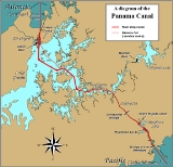
in Panama
that joins the Atlantic Ocean
and the Pacific Ocean
and is a key conduit for international maritime trade. Built from 1904 to 1914, the canal has seen annual traffic rise from about 1,000 ship
s early on to 14,702 vessels measuring a total of 309.6 million Panama Canal/Universal Measurement System (PC/UMS) tons in 2008. In total, over 815,000 vessels have passed through the canal.
1880 Ferdinand de Lesseps begins French construction of the Panama Canal.
1900 The United States and the United Kingdom sign a treaty for the Panama Canal
1902 The U.S. Congress passes the Spooner Act, authorizing President Theodore Roosevelt to acquire rights from Colombia for the Panama Canal.
1902 The United States buys the rights to the Panama Canal from France.
1903 The Hay-Herran Treaty, granting the United States the right to build the Panama Canal, is ratified by the United States Senate. The Colombian Senate would later reject the treaty.
1904 Construction begins by the United States on the Panama Canal.
1906 Theodore Roosevelt is the first sitting President of the United States to make an official trip outside the country. He did so to inspect progress on the Panama Canal.
1909 Workers start pouring concrete for the Panama Canal.
1913 President Woodrow Wilson triggers the explosion of the Gamboa Dike thus ending construction on the Panama Canal.
1914 The Panama Canal opens to traffic with the transit of the cargo ship Ancon.

in Panama
that joins the Atlantic Ocean
and the Pacific Ocean
and is a key conduit for international maritime trade. Built from 1904 to 1914, the canal has seen annual traffic rise from about 1,000 ship
s early on to 14,702 vessels measuring a total of 309.6 million Panama Canal/Universal Measurement System (PC/UMS) tons in 2008. In total, over 815,000 vessels have passed through the canal. It has been named one of the seven modern wonders of the world by the American Society of Civil Engineers
.
One of the largest and most difficult engineering
projects ever undertaken, the canal had an enormous impact on shipping
between the two oceans, replacing the long and treacherous route via either the Strait of Magellan
or Cape Horn
at the southernmost tip of South America
. A ship sailing from New York
to San Francisco via the canal travels 9500 km (5,903 mi), well under half the 22500 km (13,980.9 mi) route around Cape Horn.
The concept of a canal in Panama dates to the early 16th century. The first attempt to construct a canal began in 1880 under French
leadership, but was abandoned after 21,900 workers died, largely from disease (particularly malaria
and yellow fever
) and landslide
s. The United States launched a second effort, incurring a further 5,600 deaths but succeeding in opening the canal in 1914. The U.S. controlled the canal and the Canal Zone
surrounding it until the 1977 Torrijos–Carter Treaties provided for the transition of control to Panama. From 1979 to 1999 the canal was under joint U.S.–Panamanian administration, and from 31 December 1999 command of the waterway was assumed by the Panama Canal Authority, an agency of the Panamanian government.
While the Pacific Ocean is west of the isthmus
and the Atlantic to the east, the 8- to 10-hour journey through the canal from the Pacific to the Atlantic is one from southeast to northwest. This is a result of the isthmus's "curving back on itself" in the region of the canal. The Bridge of the Americas
at the Pacific end is about a third of a degree of longitude east of the end near Colon on the Atlantic.
The maximum size of vessel that can use the canal is known as Panamax
. A Panamax cargo ship typically has a DWT
of 65,000–80,000 tonne
s, but its actual cargo is restricted to about 52,500 tonnes because of draft
restrictions in the canal. The longest ship ever to transit was the San Juan Prospector, now Marcona Prospector, an ore-bulk-oil carrier
that is 973 ft (296.57 m) long, with a beam of 106 ft (32.31 m).
History
Early proposal
The earliest mention of a canal across the Isthmus of Panamadates to 1534, when Charles V, Holy Roman Emperor
and King of Spain
ordered a survey for a route through Panama that would ease the voyage for ships traveling to and from Spain
and Peru
, as well as give the Spanish a tactical military edge over the Portuguese. During his expedition of 1788–1793, Alessandro Malaspina
demonstrated the feasibility of a canal and outlined plans for its construction.
Given the strategic location of Panama and its isthmus
separating two great oceans, other forms of trade links were attempted over the years. The ill-fated Darien scheme
was an attempt launched by the Kingdom of Scotland
in 1698 to set up an overland trade route
, but was defeated by the generally inhospitable conditions, and abandoned in July of 1699. However, the discovery of gold in California created a great deal of interest in a crossing between the Atlantic and Pacific Oceans. Finally, the Panama Railway was built across the isthmus, opening in 1855. This overland link became a vital piece of infrastructure, greatly facilitating trade and largely determining the later canal route.
Also in 1855, William Kennish
, a Manx-born engineer in the employ of the United States government, surveyed and issued a report on a route for a proposed Panama Canal. His report was published in a book entitled The Practicality and Importance of a Ship Canal to Connect the Atlantic and Pacific Oceans.
French construction attempt
An all-water route between the oceans was still seen as the ideal solution, and the idea of a canal was enhanced by the French success of the Suez Canal(which took 10 years to build the 102 mile canal, more than twice the length of the Panama Canal). The French
, under Ferdinand de Lesseps
, began construction on a sea-level canal (i.e., without locks) through what was then Colombia
's province of Panama, on January 1, 1880. The French began work in a rush, with insufficient prior study of the geology
and hydrology
of the region. Excavation was conducted at such a steep angle that, in some years, rain-induced landslides poured nearly as much material into the canal as had been removed. In addition, disease, particularly malaria
and yellow fever
, sickened and killed vast numbers of employees, ranging from laborers to top directors of the French company. Public health measures were ineffective because the role of the mosquito
as a disease vector was then unknown. These conditions made it impossible to maintain an experienced work force as fearful technical employees quickly returned to France. Even the hospitals contributed to the problem, unwittingly providing breeding places for mosquitoes inside the unscreened wards. Actual conditions were hushed up in France to avoid recruitment problems. In 1893, after a great deal of work, the French scheme was abandoned due to disease and the sheer difficulty of building a sea-level canal, as well as lack of French field experience, such as with downpours that caused steel equipment to rust. The high toll from disease was one of the major factors in the failure; as many as 22,000 workers were estimated to have died during the main period of French construction (1881–1889).
Beyond the hygienic and technical difficulties, financial mismanagement and political corruption
also contributed to the French failure.
U.S. construction

were also expressing interest in building a canal across the isthmus, with some favouring a route across Nicaragua
(see Nicaragua Canal
and Ecocanal
) and others advocating the purchase of the French interests in Panama. Eventually, in June 1902, the U.S. Senate voted in favor of pursuing the Panamanian option, provided the necessary rights could be obtained. (It is claimed that the vote was swayed by William Nelson Cromwell
.)
On January 22, 1903, the Hay-Herran Treaty
was signed by United States Secretary of State
John M. Hay and Dr. Tomás Herrán
of Colombia. It would have granted the United States
a renewable lease
in perpetuity from Colombia
on the land proposed for the canal. This is often misinterpreted as the "99-year lease" due to misleading wording included in article 22 of the agreement that refers to property within the land but does not pertain to the control of the canal and the right for the United States to renew the lease indefinitely. It was ratified by the United States Senate on March 14, 1903, but the Senate of Colombia
did not ratify the treaty. Philippe Bunau-Varilla, chief engineer of the French canal company, told Roosevelt and Hay of a possible revolt and hoped that the U.S. would support it with troops and money. President of the United States
Theodore Roosevelt
changed tactics, promising support for the separation of Panama from Colombia
. On November 2, 1903, U.S. warships blocked sealanes for Colombian troops from coming to put down the revolt, while dense jungles blocked land routes. Panama achieved independence on November 3, 1903 when the United States
sent
naval forces to encourage Colombia
's surrender of the region. The United States quickly recognized them. Also, on November 6, 1903, Phillipe Bunau-Varilla
, Panama's ambassador to the United States, signed the Hay-Bunau Varilla Treaty
, granting rights to the United States to build and indefinitely administer the Panama Canal. Although Bunau-Varilla was serving as Panama's ambassador, he was a French citizen and was not authorized to sign treaties on behalf of Panama without Panamanian review. This treaty would later become a contentious diplomatic issue between Panama and the U.S..
The United States, under President Theodore Roosevelt
, bought out the French equipment and excavations for US$40 million and began work on May 4, 1904. The United States paid Colombia $10 million in 1921 and (later $250,000 per annum), seven years after completion of the canal, for redress of President Roosevelt's role in the creation of Panama, and Colombia recognized Panama under the terms of the Thomson-Urrutia Treaty
.
Isthmian Canal Commission
The U.S. Government created the Isthmian Canal Commissionto oversee the construction of the Panama Canal in the early years of American involvement. Established in 1904, it was given control of the Panama Canal Zone
over which the United States
exercised sovereignty. The commission reported directly to Secretary of War
William Taft.
Joseph Bucklin Bishop
, an associate of Theodore Roosevelt
and a strong editorial advocate for U.S. participation in the Canal project was appointed Executive Secretary of the Isthmian Canal Commission
in Washington, D.C. the following year. Bishop was tasked with managing the Commission’s day-to-day matters but also with ensuring public support for the canal through public relations and by keeping the project’s official history. Bishop’s promised $10,000 annual salary was relentlessly criticized by Roosevelt’s opponents in Congress, mostly because it was twice what each of them made. Opposition newspapers joined in the criticism. In the summer of 1907, when escalating allegations of cronyism surrounding Bishop’s appointment threatened appropriations for Panama Canal construction, Secretary of War, William Howard Taft
, surely with Roosevelt’s quiet consent, ordered Bishop out of Washington to Panama where the partisan political heat would be less intense. “I accept your decision without reluctance,” Bishop informed Taft, “and shall go to the Isthmus, not sadly but cheerfully”. It would not be his first trip to Panama. In the fall of the previous year, Bishop had gone ahead to advance Roosevelt’s historic inspection tour, the first time a sitting President had journeyed outside the U.S.
Joseph Bucklin Bishop would, except for month-long summer breaks, remain on the isthmus for seven years, serving clandestinely at first as Theodore Roosevelt’s “eyes and ears”. He reported back on the “astonishing” progress that Army Corps of Engineers Colonel George Washington Goethals
and his team were making excavating the “big ditch” and building dams and locks. Before long, Bishop became Goethals’s trusted aide, serving as his first line of defense against workers with complaints and grievances. But Bishop’s greatest achievement in Panama would be as founding editor of The Canal Record, a weekly newspaper for the thousands of workers in Panama. His regular reports of cubic yards dug by rival work divisions, and the competitive baseball games they played created a spirit of healthy competition that lifted worker morale and productivity. The “good news” of The Canal Record also built vital public support on newspaper editorial pages back home and in the halls of the United States Congress
where annual appropriation
s were required to keep the canal project moving forward.
Planning and construction begins
John Frank Stevens, Chief Engineer from 1905 to 1907, successfully argued the case against the incredibly massive excavation required for a sea-level canal like the French had tried to build and convinced Theodore Roosevelt of the necessity and feasibility of a canal built with dam
s and locks
. One of Stevens' primary achievements in Panama was in building the infrastructure necessary to complete the canal. He had the Panama Railway rebuilt and upgraded with modern heavy-duty equipment. Implementing the recommendations of Walter Reed
and Dr. William Gorgas, Stevens also built proper housing with screens for canal workers and oversaw investment in extensive sanitation and mosquito
-abatement programs that minimized the spread of the deadly mosquito-spread diseases—particularly malaria
and yellow fever
. The mosquito had been identified as the vector (disease spreading agent) by Cuban physician and scientist Dr. Carlos Finlay
in 1881. Finlay's theory and investigative work had recently been confirmed by Dr. Walter Reed while in Cuba
with the U.S. Army after the Spanish-American War
(1898) (see also Health measures during the construction of the Panama Canal
).
With the diseases under control, and after significant work on preparing the infrastructure and railroad, construction of an elevated canal with locks began in earnest. Even the construction of the Panama Canal with locks still required the excavation of an enormous volume of material and was envisioned by John Frank Stevens as a massive earth-moving project using the Panama Railway as efficiently as possible. The railroad, starting in 1904, had to be comprehensively upgraded with heavy-duty double-tracked rails over most of the line to accommodate all the new rolling stock of about 115 heavy-duty locomotives and 2,300 dirt spoils railroad cars. There were about 102 of the new railroad-mounted steam shovel
s brought in from the United States and elsewhere. The steam shovels were some of the largest in the world in 1906 when they were introduced. The new railroad closely paralleled the canal where it could and was moved and reconstructed where it interfered with the canal work. In many places the new Lake Gatun flooded over the original rail line and a new rail line had to be raised above the water by massive dirt fills and bridges.

, about 160 loaded dirt trains went out of the cut daily, and returned empty—one train about every one and a half minutes of the day.
The railroads, steam shovels, enormous steam-powered cranes, rock crushers, cement mixers, dredges, and pneumatic power drills used to drill holes for explosives (about 30000000 pounds (13,607.8 t) were used) were some of the new (in 1906) pieces of construction equipment used to construct the canal. Nearly all this new equipment was built by new, extensive machine building technology developed and built in the United States by companies such as the Joshua Hendy Iron Works
. In addition, the canal used large refrigeration systems for making ice, extensive large electrical motors to power the pumps and controls on the canal's locks and other new technology. They built extensive electrical generation and distribution systems—one of the first wide-scale uses of large electrical motors and generators. Electrical-powered donkey engines
pulled the ships through the locks on railroad tracks laid parallel to the locks. New technology, not available before, allowed massive earth cuts and fills to be used on the new railroad and canal that were many times larger than those done in the original 1851–1855 railroad construction. The Americans replaced the old French equipment with machinery designed for a larger scale of work (such as the giant hydraulic crushers supplied by the Joshua Hendy Iron Works) to quicken the pace of construction. President Roosevelt had the former French machinery minted into medal
s for all workers who spent at least two years on the construction to commemorate their contribution to the building of the canal. These medals featured Roosevelt's likeness on the front, the name of the recipient on one side, and the worker's years of service, as well as a picture of the Culebra Cut
on the back.
In 1907, when John Frank Stevens
resigned, Roosevelt appointed U.S. Army Colonel George Washington Goethals
as Chief Engineer of the Panama Canal.
Ellicott Dredges
, a Baltimore, Maryland, USA company formerly known as the Ellicott Machine Company, built the cutter dredges used in some of the construction of the Panama Canal after the cuts were deep enough to float them. The first machine delivered was a steam-driven, 900 hp, 20-inch dredge. In 1941, Ellicott Dredges also built the dredge MINDI, a 10000 HP, 28-inch cutter suction dredge still operating in the Panama Canal.
The building of the canal was completed in 1914, two years ahead of the target date of June 1, 1916. The canal was formally opened on August 15, 1914 with the passage of the cargo ship SS Ancon
. Coincidentally, this was also the same month that fighting in World War I
(the Great War) began in Europe
. The advances in hygiene
resulted in a relatively low death toll during the American construction; still, about 5,600 workers died during this period (1904–1914). This brought the total death toll for the construction of the canal to around 27,500.

Later developments
By the 1930s it was seen that water supply would be an issue for the canal; this prompted the building of the MaddenDam across the Chagres River
above Gatun Lake
. The dam, completed in 1935, created Madden Lake (later Alajuela Lake), which acts as additional water storage for the canal. In 1939, construction began on a further major improvement: a new set of locks for the canal, large enough to carry the larger warships which the United States was building at the time and had planned to continue building. The work proceeded for several years, and significant excavation was carried out on the new approach channels, but the project was canceled after World War II
.
After the war, U.S. control of the canal and the Canal Zone
surrounding it became contentious as relations between Panama and the U.S. became increasingly tense. Many Panamanians felt that the Canal Zone rightfully belonged to Panama; student protests were met by the fencing in of the zone and an increased military presence. The unrest culminated in riots in which approximately 20 Panamanians and 3–5 U.S. soldiers were killed on Martyr's Day, January 9, 1964. Negotiations toward a new settlement began in 1974, and resulted in the Torrijos-Carter Treaties
. Signed by President of the United States
Jimmy Carter
and Omar Torrijos
of Panama on September 7, 1977, this mobilized the process of granting the Panamanians free control of the canal so long as Panama signed a treaty guaranteeing the permanent neutrality of the canal. The treaty led to full Panamanian control effective at noon on December 31, 1999, and the Panama Canal Authority (ACP) assumed command of the waterway.
Before this handover, the government of Panama held an international bid to negotiate a 25-year contract for operation of the container shipping ports located at the canal’s Atlantic and Pacific outlets. The contract was not affiliated with the ACP or Panama Canal operations and was won by the firm Hutchison Whampoa
, a Hong Kong
-based shipping concern whose owner is Li Ka Shing
.
Layout

, several improved and artificial channels
, and three sets of locks. An additional artificial lake, Alajuela Lake (known during the American era as Madden Lake), acts as a reservoir
for the canal. The layout of the canal as seen by a ship passing from the Pacific end to the Atlantic is as follows:
- From the buoyBuoyA buoy is a floating device that can have many different purposes. It can be anchored or allowed to drift. The word, of Old French or Middle Dutch origin, is now most commonly in UK English, although some orthoepists have traditionally prescribed the pronunciation...
ed entrance channel in the Gulf of PanamaGulf of PanamaThe Gulf of Panama is a gulf in the Pacific Ocean, near the southern coast of Panama. It has a maximum width of , a maximum depth of and the size of . The Panama Canal connects the Gulf of Panama with the Caribbean Sea and the Atlantic Ocean...
(PacificPacific OceanThe Pacific Ocean is the largest of the Earth's oceanic divisions. It extends from the Arctic in the north to the Southern Ocean in the south, bounded by Asia and Australia in the west, and the Americas in the east.At 165.2 million square kilometres in area, this largest division of the World...
side), ships travel 13.2 km (8.2 mi) up the channel to the Miraflores locks, passing under the Bridge of the AmericasBridge of the AmericasThe Bridge of the Americas is a road bridge in Panama, which spans the Pacific entrance to the Panama Canal. Completed in 1962, at a cost of US$20 million, it was the only non-swinging bridge connecting the north and south American land masses until the opening of the Centennial Bridge in 2004...
. - The two-stage MirafloresMiraflores (Panama)Miraflores is the name of one of the three locks that form part of the Panama Canal and the name of the small lake that separates these locks from the Pedro Miguel locks upstream. In the Miraflores locks, vessels are lifted in three stages totalling 8 m, allowing them to transit to or from the...
lock system, including the approach wall, is 1.7 km (1.1 mi) long, with a total lift of 16.5 meters (54 ft) at mid-tide. - The artificial Miraflores Lake is the next stage, 1.7 km (1.1 mi) long, and 16.5 meters (54 ft) above sea level.
- The single-stage Pedro Miguel lock, which is 1.4 km (0.869921831309729 mi) long, is the last part of the ascent with a lift of 9.5 meters (31 ft) up to the main level of the canal.
- The Gaillard (Culebra) CutGaillard CutThe Gaillard Cut, or Culebra Cut, is an artificial valley that cuts through the continental divide in Panama. The cut forms part of the Panama Canal, linking Lake Gatún, and thereby the Atlantic Ocean, to the Gulf of Panama and hence the Pacific Ocean...
slices 12.6 km (7.8 mi) through the continental divideContinental divideA continental divide is a drainage divide on a continent such that the drainage basin on one side of the divide feeds into one ocean or sea, and the basin on the other side either feeds into a different ocean or sea, or else is endorheic, not connected to the open sea...
at an altitude of 26 meters (85 ft), and passes under the Centennial BridgeCentennial Bridge, PanamaPanama's Centennial Bridge is a major bridge crossing the Panama Canal. It was built to supplement the overcrowded Bridge of the Americas, and to replace it as the carrier of the Pan-American Highway; upon its opening in 2004, it became only the second permanent crossing of the canal.-...
. - The Chagres RiverChagres RiverThe Chagres River is a river in central Panama. The central part of the river is dammed by the Gatun Dam and forms Gatun Lake, an artificial lake that constitutes part of the Panama Canal. Upstream lies the Madden Dam, creating the Alajuala Lake that is also part of the Canal water system...
(Río Chagres), a natural waterway enhanced by the damming of Lake Gatún, runs west about 8.5 km (5.3 mi), merging into Lake Gatun. - Gatun LakeGatun LakeGatun Lake is a large artificial lake situated in the Republic of Panama; it forms a major part of the Panama Canal, carrying ships for of their transit across the Isthmus of Panama....
, an artificial lake formed by the building of the Gatun DamGatun DamThe Gatun Dam is a large earthen dam across the Chagres River in Panama, near the town of Gatun. The dam, constructed between 1907 and 1913, is a crucial element of the Panama Canal; it impounds the artificial Gatun Lake, which in turn carries ships for of their transit across the Isthmus of Panama...
, carries vessels 24.2 km (15 mi) across the isthmus. - The Gatún locks, a three-stage flight of locks 1.9 km (1.2 mi) long, drop ships back down to sea level.
- A 3.2 km (2 mi) channel forms the approach to the locks from the Atlantic side.
- Limón Bay (Bahía Limón), a huge natural harbour, provides an anchorage for some ships awaiting passage, and runs 8.7 km (5.4 mi) to the outer breakwater.
Thus, the total length of the canal is 77.1 km (47.9 mi).
Point | Coordinates Geographic coordinate system A geographic coordinate system is a coordinate system that enables every location on the Earth to be specified by a set of numbers. The coordinates are often chosen such that one of the numbers represent vertical position, and two or three of the numbers represent horizontal position... (links to map & photo sources) |
Notes |
---|---|---|
Atlantic Entrance | 9.38743°N 79.91863°W | |
Gatún Locks | 9.27215°N 79.92266°W | |
Trinidad Turn | 9.20996°N 79.92408°W | |
Bohío Turn | 9.17831°N 79.86667°W | |
Orchid Turn | 9.18406°N 79.84513°W | |
Frijoles Turn | 9.15904°N 79.81362°W | |
Barbacoa Turn | 9.12053°N 79.80395°W | |
Mamei Turn | 9.11161°N 79.76856°W | |
Gamboa Reach | 9.11774°N 79.72257°W | |
Bas Obispo Reach | 9.09621°N 79.68446°W | |
Las Cascadas Reach | 9.07675°N 79.67492°W | |
Empire Reach | 9.06104°N 79.66309°W | |
Culebra Reach | 9.04745°N 79.65017°W | |
Cucaracha Reach | 9.03371°N 79.63736°W | |
Paraiso Reach | 9.02573°N 79.62492°W | |
Pedro Miguel Locks | 9.01698°N 79.61281°W | |
Miraflores Lake | 9.00741°N 79.60254°W | |
Miraflores Locks | 8.99679°N 79.59182°W | |
Balboa Reach | 8.97281°N 79.57771°W | |
Pacific Entrance | 8.88846°N 79.52145°W |
Lock size

vessels.
Initially the locks
at Gatun had been designed to be 28.5 metres (93.5 ft) wide. In 1908 the United States Navy
requested that width be increased to at least 36 metres (118.1 ft) which would allow the passage of U.S. naval ships. Eventually a compromise was made and the locks were built 33.53 metres (110 ft) wide. Each lock is 320 metres (1,049.9 ft) long with the walls ranging in thickness from 15 metres (49.2 ft) at the base to 3 metres (9.8 ft) at the top. The central wall between the parallel locks at Gatún is 18 metres (59.1 ft) thick and stands in excess of 24 metres (78.7 ft) high. The steel lock gates measure an average of 2 metres (6.6 ft) thick, 19.5 metres (64 ft) wide and 20 metres (65.6 ft) high. It is the size of the locks, specifically the Pedro Miguel Locks, along with the height of the Bridge of the Americas
at Balboa, that determine the Panamax metric and limit the size of ships that may use the Canal.
The 2006 Third lock lane project will create larger locks, and deeper and wider channels, allowing bigger ships to transit. The allowed dimensions of ships will increase by 25% in length, 51% in beam, and 26% in draft, as defined by New Panamax.
Tolls

For container ship
s, the toll is assessed per the ship's capacity expressed in twenty-foot equivalent unit
s or TEUs. One TEU is the size of a container measuring 20 feet (6.1 m) by 8 feet (2.44 m) by 8.5 feet (2.6 m). Effective May 1, 2009, this toll is US$72.00 per TEU. A Panamax container ship may carry up to . The toll is calculated differently for passenger ships and for container ships carrying no cargo (“in ballast”). , the ballast rate is US$57.60 per TEU.
Passenger vessels in excess of 30,000 tons (PC/UMS), known popularly as cruise ships, pay a rate based on the number of berths, that is, the number of passengers that can be accommodated in permanent beds. The per-berth charge is currently $92 for unoccupied berths and $115 for occupied berths. Started in 2007, this charge has greatly increased tolls for such vessels. Passenger vessels of less than 30,000 tons or with less than 33 tons per passenger are charged on the same "per-ton" schedule as freighters.
Most other types of vessel pay a toll per PC/UMS net ton
, in which one "ton" is actually a volume of 100 cubic feet (2.83 m³). (The calculation of tonnage
for commercial vessels is quite complex.) , this toll is US$3.90 per ton for the first 10,000 tons, US$3.19 per ton for the next 10,000 tons, and US$3.82 per ton for the next 10,000 tons, and US$3.76 per ton thereafter. As with container ships, a reduced toll is charged for freight ships "in ballast".
Small vessels up to 583 PC/UMS net tons when carrying passengers or cargo, or up to 735 PC/UMS net tons when in ballast, or up to 1,048 fully loaded displacement tons, are assessed minimum tolls based upon their length overall, according to the following table :
Length of vessel | Toll |
---|---|
Up to 15.240 meters (50 ft) | US$1,300 |
More than 15.240 meters (50 ft) up to 24.384 meters (80 ft) | US$1,400 |
More than 24.384 meters (80 ft) up to 30.480 meters (100 ft) | US$1,500 |
More than 30.480 meters (100 ft) | US$2,400 |
The most expensive regular toll for canal passage to date was charged on May 16, 2008 to the Disney Magic
, which paid US$331,200. The least expensive toll was 36 cents
to American adventurer Richard Halliburton
, who swam the canal in 1928. The average toll is around US$54,000. The highest fee for priority passage charged through the Transit Slot Auction System was US$220,300, paid on August 24, 2006 by the Panamax tanker
Erikoussa, bypassing a 90-ship queue waiting for the end of maintenance works on the Gatun locks
, thus avoiding a seven-day delay. The normal fee would have been just US$13,430.
Current issues
Ninety-seven years since its opening, the canal continues to enjoy great success. Even though world shipping—and the size of ships themselves—has changed markedly since the canal was designed, it continues to be a vital link in world trade, carrying more cargo than ever before, with fewer overhead costs. Nevertheless, the canal faces a number of potential problems.Efficiency and maintenance
There were fears that efficiency and maintenance would suffer following the U.S. withdrawal; however, this does not appear to have been the case. Capitalizing on practices developed during the American administration, canal operations are improving under Panamanian control. Canal Waters Time (CWT), the average time it takes a vessel to navigate the canal, including waiting time, is a key measure of efficiency; according to the ACP, since 2000, it has oscillated between 20 and 30 hours. The accident rate has also not changed appreciably in the past decade, varying between 10 and 30 accidents each year across approximately 14,000 total annual transits. An official accident is one in which a formal investigation is requested and conducted.Increasing volumes of imports from Asia
which previously landed on the U.S. west-coast ports are now passing through the canal to the American east coast. The total number of oceangoing transits increased from 11,725 in 2003 to 13,233 in 2007, falling to 12,855 in 2009. (the Canal’s fiscal year runs from October to September). This has been coupled with a steady rise in average ship size and in the numbers of Panamax vessels passing, so that the total tonnage carried rose from 227.9 million PC/UMS tons
in fiscal year 1999 to a record high of 312.9 million tons in 2007, falling to 299.1 million tons in 2009. Despite the reduction in total transits due to the negative impact of vessel size (e.g., the inability of large vessels to pass each other in the Gaillard Cut
), this represents significant overall growth in canal capacity.

fleet by 20%. In addition, improvements have been made to the operating machinery of the canal, including an increased and improved tug locomotive fleet, the replacement of more than 16 km of locomotive track, and new lock machinery controls. Improvements have been made to the traffic management system to allow more efficient control over ships in the canal.
In December 2010, record breaking rain totals caused a 17-hour closure of the canal; this was the first closure since the American invasion in 1989. Also, an access road to the Centenario bridge collapsed.
Capacity
The canal is presently handling more vessel traffic than had ever been envisioned by its builders. In 1934 it was estimated that the maximum capacity of the canal would be around 80 million tons per year; as noted above, canal traffic in 2009 consisted of 299.1 million tons of shipping.
- Implementation of an enhanced locks lighting system;
- Construction of two tie-up stations in Gaillard Cut;
- Gaillard Cut widening from 192 to 218 m (629.9 to 715.2 ft);
- Improvements to the tugboat fleet;
- Implementation of the carousel lockage system in Gatun locks;
- Development of an improved vessel scheduling system;
- Deepening of Gatun Lake navigational channels from 10.4 to 11.3 m (34.1 to 37.1 ft) PLD
- Modification of all locks structures to allow an additional draft of about 0.3
m;
- Deepening of the Pacific and Atlantic entrances;
- Construction of a new spillway in Gatun, for flood control.
These improvements will enlarge the capacity from 280–290 million PCUMS (2008) to 330–340 PCUMS (2012).
Competition
Despite having enjoyed a privileged position for many years, the canal is increasingly facing competition from other quarters. Because canal tolls are expected to rise, some critics have suggested that the Suez Canalmay become a viable alternative for cargo en route from Asia to the U.S. east coast. The Panama Canal, however, continues to serve more than 144 of the world’s trade routes and the majority of canal traffic comes from the "All-Water Route" (the route from Asia to the U.S. East and Gulf Coasts via the Panama Canal).
The increasing rate of melting of ice in the Arctic Ocean
has led to speculation that the Northwest Passage
or Arctic Bridge
may become viable for commercial shipping at some point in the future. This route would save 9300 km (5,778.8 mi) on the route from Asia to Europe compared with the Panama Canal, possibly leading to a diversion of some traffic to that route. However, such a route is beset by unresolved territorial issues and would still hold significant problems owing to ice.
Water issues
Gatun Lake is filled with rainwater, and the lake accumulates excess water during wet months. The water is lost to the oceans at a rate of 101000 m³ (26,681,375.8 US gal; 22,216,894.1 imp gal) per lock-cycle going downwards. Since a ship will have to go upward to Lake Gatun first and then descend, a single passing will cost double the amount, but the same waterflow cycle can be used for another ship passing in the opposite direction. The ship's submerged volume is not relevant to the amount of water. During the dry season, when there is less rainfall, there is also a shortfall of water in Gatun Lake.
As a signatory to the United Nations
Global Compact and a member of the World Business Council for Sustainable Development, the ACP has developed an environmentally and socially sustainable program for expansion, which will protect the aquatic and terrestrial resources of the Canal Watershed. After completion, expansion will guarantee the availability and quality of water resources
by using unique water-saving basins at each new lock. These water-saving basins will diminish water loss and preserve freshwater resources along the waterway by reusing water from the basins into the locks. Each lock chamber will have three water-saving basins, which will reuse 60 percent of the water in each transit. There are a total of nine basins for each of the two lock complexes, and a total of 18 basins for the entire project.
The Pacific side sea level is about 20 centimeters (8 inches) higher than that of the Atlantic side due to differences in ocean conditions such as water densities and weather conditions.
The future
As demand is rising, the canal is positioned to be a significant feature of world shipping for the foreseeable future. However, changes in shipping patterns—particularly the increasing numbers of post-Panamax ships—will necessitate changes to the canal if it is to retain a significant market share. It is anticipated that by 2011, 37% of the world's container ships will be too large for the present canal, and hence a failure to expand would result in a significant loss of market share. The maximum sustainable capacity of the present canal, given some relatively minor improvement work, is estimated at between 330 and 340 million PC/UMS tons per year; it is anticipated that this capacity will be reached between 2009 and 2012. Close to 50% of transiting vessels are already using the full width of the locks.
An enlargement scheme similar to the 1939 Third Lock Scheme, to allow for a greater number of transits and the ability to handle larger ships, has been under consideration for some time, has been approved by the government of Panama, and is in progress, with completion expected in 2014. The cost is estimated at US$5.25 billion, and the project will double the canal's capacity and allow more traffic and the passage of longer and wider ships. This proposal to expand the canal was approved in a national referendum
by approximately 80% on October 22, 2006.
Third set of locks project
The current plan is for two new flights of locks to be built parallel to, and operated in addition to, the old locks: one to the east of the existing Gatún locks, and one south west of Miraflores locks, each supported by approach channels. Each flight will ascend from ocean level direct to the Gatún Lake level; the existing two-stage ascent at Miraflores / Pedro Miguel will not be replicated. The new lock chambers will feature sliding gates, doubled for safety, and will be 427 meters (1,400 ft) long, 55 meters (180 ft) wide, and 18.3 meters (60 ft) deep; this will allow the transit of vessels with a beam of up to 49 meters (160 ft), an overall length of up to 366 meters (1,200 ft) and a draft of up to 15 meters (50 ft), equivalent to a container ship carrying around 12,000 twenty-foot (6.1 m) long containers (TEU).The new locks will be supported by new approach channels, including a 6.2 km (3.9 mi) channel at Miraflores from the locks to the Gaillard Cut, skirting around Miraflores Lake. Each of these channels will be 218 meters (715 ft) wide, which will require post-Panamax vessels to navigate the channels in one direction at a time. The Gaillard Cut and the channel through Gatún Lake will be widened to no less than 280 meters (918 ft) on the straight portions and no less than 366 meters (1,200 ft) on the bends. The maximum level of Gatún Lake will be raised from reference height 26.7 meters (87.5 ft) to 27.1 meters (89 ft).
Each flight of locks will be accompanied by nine water reutilization basins (three per lock chamber), each basin being approximately 70 meters (230 ft) wide, 430 meters (1410 ft) long and 5.50 meters (18 ft) deep. These gravity-fed basins will allow 60% of the water used in each transit to be reused; the new locks will consequently use 7% less water per transit than each of the existing lock lanes. The deepening of Gatún Lake, and the raising of its maximum water level, will also provide significant extra water storage capacity. These measures are intended to allow the expanded canal to operate without the construction of new reservoirs.
The estimated cost of the project is US$5.25 billion. The project is designed to allow for an anticipated growth in traffic from 280 million PC/UMS tons in 2005 to nearly 510 million PC/UMS tons in 2025; the expanded canal will have a maximum sustainable capacity of approximately 600 million PC/UMS tons per year. Tolls will continue to be calculated based on vessel tonnage, and will not depend on the locks used.
The new locks are expected to open for traffic in 2015. The present locks, which will be 100 years old by that time, will then have greater access for maintenance, and are projected to continue operating indefinitely. An article in the February 2007 issue of Popular Mechanics magazine describes the plans for the canal, focusing on the engineering aspects of the expansion project. There is also a follow-up article in the February 2010 issue of Popular Mechanics magazine.
On September 3, 2007, thousands of Panamanians stood across Paraíso
Hill in Panama to witness a huge explosion
and the launch of the Expansion Program. The first phase of the project will be dry excavations of the 218 meter (715 ft) wide trench
connecting the Culebra Cut with the Pacific coast
, removing 47 million cubic meters of earth and rock.
Building the new canal
It was announced in July 2009 that the Belgiandredging company Jan De Nul
, together with a consortium of contractors consisting of the Spanish
Sacyr Vallehermoso, the Italian
Impregilo and the Panamanian company Cusa, had been awarded the contract to build the six new locks. The contract will result in $100 million in dredging works over the next few years for the company, and a great deal of work for the company's construction division. The design of the locks is a carbon copy of the Berendrecht lock which is 68m wide and 500m long, making it the largest lock in the world. Completed in 1989 by the Port of Antwerp
, which De Nul helped build, the company still has engineers and specialists who were part of that project.
Rival Colombia rail link
China is looking into constructing a 220 km railway between Colombia's Pacific and Caribbean coasts.Canal Pilots
During the last one hundred years, the Autoridad del Canal de Panamá has appointed a few "Panama Canal Honorary Pilots". The most recent of these were Commodore Ronald Warwick, a former Masterof the Cunard Line
's RMS Queen Mary 2
, who has traversed the Canal more than 50 times, and Captain Raffaele Minotauro, Master Senior Grade, of the former Italian governmental navigation company known in the shipping world as the "Italian Line
.
Gatun Lake
Created in 1913 by the damming of the Charges River, Gatun Lakeis an essential part of the Panama Canal which forms a water passage between the Atlantic Ocean and the Pacific Ocean, permitting ship transit in both directions. At the time it was formed Gatun Lake was the largest man-made lake in the world. The impassable rain-forest around Gatun Lake has been the best defense of the Panama Canal. Today these areas have endured practically unscathed by human interference and are one of the few accessible areas on earth that various native Central American animal and plant species can be observed undisturbed in their natural habitat. World famous Barro Colorado Island, which was established for scientific study when the lake was formed and is today operated by the Smithsonian Institution, is the largest island on Gatun Lake. Many of the most important ground breaking scientific and biological discoveries of the tropical animal and plant kingdom originated here. Lake Gatun encompasses approximately 180 square miles (466.2 km²), a vast tropical ecological zone part of the Atlantic Forest Corridor and Eco-tourism on Gatun Lake has become a worthwhile industry for Panamanians.
Gatun Lake also serves to provide the millions of gallons of water necessary to operate the Panama Canal locks each time a ship passes through and provides drinking water for Panama City and Colon. Angling is one of the primary recreational pursuits on Gatun Lake. It is suspected that the Cichla Pleiozona species of Peacock Bass was introduced by accident to Gatun Lake by a renowned Panamanian aquarist and doctor in 1958. Locally called Sargento these peacock bass are not a native game fish of Panama but originate from the Amazon, Rio Negro and Orinoco river basins of South America where they are called Tucanare or Pavon and are considered a premier game fish. Since 1958 the Cichla Pleiozona species of Peacock Bass have flourished to become the dominant angling game fish in Gatun Lake.
See also
- Canal Zone PoliceCanal Zone PoliceThe Canal Zone Police was a force that consisted of more than 400 police officers of all ranks split into two Divisions, Atlantic and Pacific, and between about 25 stations...
- Cost overrunCost overrunA cost overrun, also known as a cost increase or budget overrun, is an unexpected cost incurred in excess of a budgeted amount due to an under-estimation of the actual cost during budgeting...
- Isthmus of TehuantepecIsthmus of TehuantepecThe Isthmus of Tehuantepec is an isthmus in Mexico. It represents the shortest distance between the Gulf of Mexico and the Pacific Ocean, and prior to the opening of the Panama Canal was a major shipping route known simply as the Tehuantepec Route...
Tehuantepec Route - List of waterways
- Nicaragua CanalNicaragua CanalThe Inter-Oceanic Nicaragua Canal was a proposed waterway through Nicaragua to connect the Caribbean Sea and Atlantic Ocean with the Pacific Ocean...
- Strait of MagellanStrait of MagellanThe Strait of Magellan comprises a navigable sea route immediately south of mainland South America and north of Tierra del Fuego...
Further reading
- Jaen, Omar. (2005). Las Negociaciones de los Tratados Torrijos-Carter, 1970-1979 (Tomos 1 y 2). Panama: Autoridad del Canal de Panama. ISBN 9962-607-32-9 (Obra completa)
- Jorden, William J. (1984). Panama Odyssey. 746 pages, illustrated. Austin: University of Texas PressUniversity of Texas PressThe University of Texas Press is a university press that is part of the University of Texas at Austin. Established in 1950, the Press publishes scholarly books in several areas, including Latin American studies, Texana, anthropology, U.S...
. ISBN 0-292764-69-3 - McCullough, DavidDavid McCulloughDavid Gaub McCullough is an American author, narrator, historian, and lecturer. He is a two-time winner of the Pulitzer Prize and the National Book Award and a recipient of the Presidential Medal of Freedom, the United States' highest civilian award....
. (1977). The Path Between the Seas: The Creation of the Panama Canal, 1870-1914The Path Between the SeasThe Path Between the Seas: The Creation of the Panama Canal, 1870—1914 is a 1977 book by noted historian David McCullough that details the people and places involved in building the Panama Canal...
. New York: Simon & Schuster. ISBN 0-671-22563-4 - Maurer, Noel, and Carlos Yu. The Big Ditch: How America Took, Ran, and
Ultimately Gave Away the Panama Canal (Princeton University Press, 2010); 420 pp. ISBN 978-0-691-14738-3. Econometric analysis of costs ($9 billion in 2009 dollars) and benefits to US and Panama
- Mellander, Gustavo A.(1971) The United States in Panamanian Politics: The Intriguing Formative Years. Daville,Ill.:Interstate Publishers. OCLC 138568.
- Mellander, Gustavo A.; Nelly Maldonado Mellander (1999). Charles Edward Magoon: The Panama Years. Río Piedras, Puerto Rico: Editorial Plaza Mayor. ISBN 1563281554. OCLC 42970390.
- Murillo, Luis E. (1995). The Noriega Mess: The Drugs, the Canal, and Why America Invaded. 1096 pages, illustrated. Berkeley: Video Books. ISBN 0-923444-02-5.
- Parker, Matthew. (2007). Panama Fever: The Epic Story of One of the Greatest Human Achievements of All Time - The Building of the Panama Canal. New York: Doubleday. ISBN 978-0-385-51534-4
- Sherman, Gary. "Conquering the Landscape (Gary Sherman explores the life of the great American trailblazer, John Frank Stevens)," History Magazine, July 2008.
- Cullen, Ben. (2010). The Panama Canal and Me: A Panamax Special. ISBN 9780821277546
- Mills, J. Saxon. (1913). The Panama Canal -- A history and description of the enterprise A Project Gutenberg free ebook.
External links
- Panama Canal Authority website - Has a simulation showing how the canal works
- Making the Dirt Fly, Building the Panama Canal Smithsonian Institution Libraries
- Canalmuseum — History, Documents, Photographs and Stories
- History of the Canal Zone from CZ Brats
- Judicial Watch, Inc. v. Panama Canal Commission case - archived
- http://content.lib.washington.edu/cgi-bin/queryresults.exe?CISOOP=adv&CISORESTMP=%2Fsite-templates%2Fsearch_results-sub.html&CISOVIEWTMP=%2Fsite-templates%2Fitem_viewer.html&CISOMODE=thumb&CISOGRID=thumbnail%2CA%2C1%3Btitle%2CA%2C1%3Bsubjec%2CA%2C0%3Bdescri%2C200%2C0%3B0%2CA%2C0%3B10&CISOBIB=title%2CA%2C1%2CN%3Bsubjec%2CA%2C0%2CN%3Bdescri%2CK%2C0%2CN%3B0%2CA%2C0%2CN%3B0%2CA%2C0%2CN%3B10&CISOTHUMB=3%2C5&CISOTITLE=10&CISOPARM=%2Ffishimages%3Asubjec%3Apanama&x=29&y=0Freshwater and Marine Image Bank – Panama Canal] University of Washington Libraries - ongoing digital collection of images
- Early stereographic images of the construction University of California
- A.B. Nichols Panama Canal Collection at the Linda Hall Library Archival collection of maps, blueprints, photographs, letters, and other documents, collected by Aurin B. Nichols, an engineer who worked on the canal project through from 1899 until its completion.
- 2700 digitised National Archives public domain images Photos of the building and early days of the Panama Canal digitised by GoZonian.org from the U.S. National Archives and Records Administration. Originally from 8 x 10 glass plates
- Gatun Lake Benefits
- Panama & the Canal Digital Collection
- New Plans For Panama, by Stephen L. Freeman 1947 article about possible post World War II plans for the Panama Canal including first mention of a sea level canal to replace the locks
- Footage of ships going through Panama Canal in 1917