

Oaxaca
Encyclopedia
Oaxaca (from Nahuatl
: Huaxyacac, IPA:/ʋaːsʃʲa'kakʰ/), officially Estado Libre y Soberano de Oaxaca (Free and Sovereign State of Oaxaca) is one of the 31 states which, along with the Federal District
, comprise the 32 federative entities of Mexico
. It is divided into 571 municipalities
; of which 418 (almost three quarters) are governed by the system of customs and traditions. Its capital city is Oaxaca de Juárez.
It is located in Southwestern Mexico
. It is bordered by the states of Guerrero
to the west, Puebla
to the northwest, Veracruz
to the north, Chiapas
to the east. To the south, Oaxaca has a significant coastline on the Pacific Ocean.
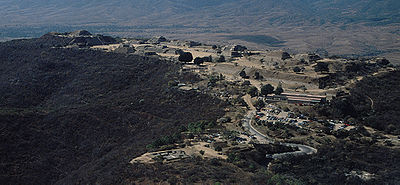
The state is best known for its indigenous peoples and cultures. The most numerous and best known are the Zapotecs and the Mixtecs, but there are sixteen that are officially recognized. These cultures have survived better to the present than most others in Mexico due to the state’s rugged and isolating terrain. Most live in the Central Valleys region, which is also an important area for tourism, attracting people for its archeological sites such as Monte Albán
, native culture and crafts. Another important tourist area is the coast, which has the major resort of Huatulco
. The state also has some of the greatest biodiversity in Mexico.
word “Huaxyacac”, which refers to a tree called a “guaje” (Leucaena leucocephala), found in area around the capital city. The name was originally applied to the Valley of Oaxaca
by Nahuatl speaking Aztecs and passed on to the Spanish when they were accompanied by Aztecs in the conquest of the Oaxaca area. The modern state was created in 1824, and the state seal was designed by Alfredo Canseco Feraud and approved by the government of Eduardo Vasconcelos.
. This area was recognized as a UNESCO World Heritage site in 2010 in recognition for the "earliest known evidence of domesticated plants in the continent, while corn cob fragments from the same cave are said to be the earliest documented evidence for the domestication of maize." More finds of nomadic peoples date back to about 5000 BCE, with some evidence of the beginning of agriculture. By 2000 BCE, agriculture had been established in the Central Valleys region of the state, with sedentary villages. The diet developed around this time would remain until the Spanish Conquest, consisting primarily of harvested corn, beans, chocolate, tomatoes, chili peppers, squash and gourds. Meat was generally hunted and included tepescuintle
, turkey, deer, peccary
, armadillo
and iguana
.
The oldest known major settlements, such as Yanhuitlán
and Laguna Zope are located in this area as well. The latter settlement is known for its small figures called “pretty women” or “baby face.” Between 1200 and 900 BCE, pottery was being produced in the area as well. This pottery has been linked with similar work done in La Victoria, Guatemala. Other important settlements from the same time period include Tierras Largas
, San José Mogote
and Guadalupe
, whose ceramics show Olmec
influence. The major native language family, Oto-Manguean
, is thought to have been spoken in northern Oaxaca around 4400 BCE and to have evolved into nine distinct branches by 1500 BCE.
Historic events in Oaxaca as far back as the 12th century are described in pictographic codices painted by Zapotecs and Mixtecs in the beginning of the colonial period, but outside of the information that can be obtained through their study, little historical information from pre-colonial Oaxaca exist, and our knowledge of this period relies largely on archaeological remains. By 500 BCE, the central valleys of Oaxaca were mostly inhabited by the Zapotecs, with the Mixtecs on the western side. These two groups were often in conflict throughout the pre-Hispanic period. Archeological evidence indicates that between 750 and 1521, there may have been population peaks of as high as 2.5 million.
The Zapotecs were the earliest to gain dominance over the Central Valleys region. The first major dominion was centered in Monte Albán, which flourished from 500 BCE until 750 CE. At its height, Monte Albán
was home to some 25,000 people and was the capital city of the Zapotec nation. It remained a secondary center of power for the Zapotecs until the Mixtecs overran it in 1325. The site contains a number of notable features including the Danzantes, a set of stone reliefs and the finding of fine quality ceramics.
 Starting from 750 CE previous large urban centers such as Monte Alban fell across the Oaxaca area and smaller dominions grew and evolved until the Spanish Conquest in 1521. Between 700 and 1300, the Mixtec were scattered among various dominions, including those of Achiutla, Tequixtepec-Chazumba, Apoala and Coixtlahuaca
. The Zapotecs occupied a large region from Central Valleys region to the Isthmus of Tehuantepec. However, no major city state like Monte Albán arose again, with villages and city-states remaining small, between 1,000 and 3,000 people with a palace, temple, market and residences. In a number of cases, there were Mesoamerican ball courts as well. These and larger centers also functioned as military fortresses in time of invasion. Important Zapotec and Mixtec sites include Yagul
, Zaachila
, Inguiteria, Yanhuitlan, Tamazulapan, Tejupan, and Teposcolula. During nearly all of this time, these various entities were at war with one another, and faced the threat of Aztec expansion.
While the Zapotec remained dominant in many parts of the Central Valleys and into the Isthmus of Tehuantepec, the Mixtec were pushing into Zapotec territory, taking Monte Alban. In areas they conquered, they became prolific builders, leaving behind numerous and still unexplored sites. However, the conquest of the Central Valleys was never completed with pressure coming from the Aztecs in Tenochtitlan in the 14th and 15th centuries. The Zapotecs and Mixtecs both allied themselves and fought among themselves as they tried to maintain their lands and valuable trade routes between the high central plains of Mexico and Central America.
The first Aztecs arrived to the Oaxaca area in 1250, but true expansion into the region began in the 15th century. In 1457, Moctezuma I invaded the Tlaxiaco and Coixtlahuaca areas, gaining control, demanding tribute and establishing military outposts. These were Mixtec lands at first, pushing these people even further into Zapotec territory. Under Axayacatl
and Tizoc
, the Aztec began to take control of trade routes in the area and part of the Pacific Coast. By this time, the Zapotec were led by Cosijoeza
with the government in Zaachila in the latter 15th century. Under Ahuitzotl, the Aztecs temporarily pushed the Zapotecs into Tehuantepec and established a permanent military base at Huaxyacac (Oaxaca city). The Aztecs were stopped only by the Spanish Conquest. These conquests would change most of the place names in parts of Oaxaca to those from the Nahuatl language. In 1486 the Aztecs established a fort on the hill of Huaxyácac (now called El Fortín), overlooking the present city of Oaxaca. This was the major Aztec military base charged with the enforcement of tribute collection and control of trade routes.
However, Aztec rule in Oaxaca would last only a little more than thirty years.
 Very soon after the fall of Tenochtitlan (Mexico City), Spaniards arrived in Oaxaca. Moctezuma II
had informed Hernán Cortés
that the area had gold. In addition, when Zapotec leaders heard about the Spanish conquest of the Aztec Empire, they sent an offer of an alliance. Several captains and representatives were sent to the area to explore the area, looking for gold, and routes to the Pacific to establish trade routes to Asian spice markets. The most prominent of Cortés’ captains to arrive here were Gonzalo de Sandoval
, Francisco de Orozco and Pedro de Alvarado
. They overcame the main Aztec military stronghold only four months after the fall of Tenochtitlan. Their reports about the area prompted Cortés to seek the title of the Marquis of the Valley of Oaxaca from the Spanish Crown.
The valley Zapotecs, the Mixtecs of the Upper Mixteca, the Mazatecas and the Cuicatecas, for the most part, choose not to fight the newcomers, instead negotiating to keep most of the old hierarchy but with ultimate authority to the Spanish. Resistance to the new order was sporadic and confined to the Pacific coastal plain, the Zapotec Sierra, the Mixe region and the Isthmus of Tehuantepec. The Mixes put the most resistance to intrusions on their lands. They not only resisted during the first decade or so of Spanish occupation, like other groups, but through the rest of the 16th century. The last major Mixe rebellion came in 1570, when they burned and looted Zapotec communities and threatened to destroy the Spanish presidio of Villa Alta. However, this rebellion was put down by the Spanish, in alliance with about 2,000 Mixtecs and Aztecs. From this point, the Mixe retreated far into the mountains to isolate themselves, where they are found today.
The first priest in the territory was Juan Diaz, who accompanied Francisco de Orozco and build the first church in what is now the city of Oaxaca. He was followed by Bartolome de Olmade and others who began the superficial conversion of a number of indigenous, including the baptism of Zapotec leader Cosijoeza. In 1528, the Dominicans settled in the city of Oaxaca, forming the Bishopric of Oaxaca in 1535, and began to spread out from there, eventually reaching Tehuantepec and the coast. Other orders followed such as the Jesuits in 1596, the Mercedarians in 1601, and others in the 17th and 18th centuries.
Spanish conquest and subsequent colonization had a devastating effect on the native population, due to European diseases and forced labor. In some areas the native population nearly or completely disappeared. It has been estimated that the native population of the region declined from 1.5 million in 1520 to 150,000 in 1650. Eventually, this would prompt the Spanish to import African slaves to some regions of the state, mostly in the Costa Chica
. This poor treatment of indigenous and African populations would continue though the colonial period. Initially, the Spanish did not change native power structures and allowed nobles to keep their privileges as long as they were loyal to the Spanish crown. However, all indigenous were eventually lumped into the category as the Spanish halted warfare among the city-states and creating the official category of “indio” (Indian).
Settlers arriving from Spain brought with them domestic animals that had never been seen in Oaxaca: horses, cows, goats, sheep, chickens, mules and oxen. New crops such as sugar cane, vanilla and tobacco were introduced. However, landholding still remained mostly in indigenous hands, in spite of the fact that only 9% of Oaxaca’s terrain is arable. Spanish official and merchants would try to take indigenous privileges due to their social status, but this was resisted. While some of this was violent, the dominant response was to resort to the administrative-judicial system or yield. Violence was reserved for the worst of situations. One native product to reach economic importance during the colonial period was the cochineal
insect, used for the making of dyes for textiles. This product was exported to Europe, especially in the 17th and 18th centuries. The use of this insect faded in the 19th century with the discovery of cheaper dyes.
For much of the colonial period, the state (then an intendencia or province) was relatively isolated with few roads and other forms of communication. Most politics and social issues were strictly on the local level. Despite Spanish domination, the indigenous peoples of Oaxaca have to maintain much of their culture and identity, more so than most other places in Mexico. Part of this is due to the geography of the land, making many communities isolated.
 By 1810, the city of Oaxaca had 18,000 inhabitants, most of whom where mestizo
s or mixed indigenous/European. During the Mexican War of Independence
the government of this area remained loyal to the Spanish Crown. When representatives of Miguel Hidalgo y Costilla came to meet with them, they were hanged and their heads left out in view. Some early rebel groups emerged in the state, such as those led by Felipe Tinoco and Catarino Palacios, but they were also eventually executed. After 1812, insurgents began to have some success in the state, especially in the areas around Huajuapan de León, where Valerio Trujano defended the city against royalist forces until José María Morelos y Pavón was able to come in with support to keep the area in rebel hands. After that point, insurgents had greater success in various parts of the state, but the capital remained in royalist hands until the end of the war.
The state was initially a department after the war ended in 1821, but after the fall of emperor Agustín de Iturbide
, it became a state in 1824 with Jose Maria Murguia named as its first governor.
During the 19th century, Oaxaca and the rest of Mexico was split between liberal (federalist) and conservative (centralist) factions. The political and military struggles between the factions resulted in wars and intrigues. Vicente Guerrero
, a liberal, was executed by firing squad in Cuilapam
in 1831. Liberal Manuel Gomez Pedraza became governor in 1832 but was opposed by General Estaban Moctezuma. He and commandant Luis Quintanar persecuted liberals in the state, including Benito Juárez
. The constant warfare had a negative effect on the state’s economy and those in the Tehuantepec area supported a separatist movement which was partially successful in the 1850s.
Two Oaxacans, Benito Juarez and Porfirio Díaz
were prominent players in the Reform War
. It is difficult to overstate Juárez’s meaning to the state. He was born on March 21, 1806 in the village of San Pablo Guelatao
and was full blooded Zapotec. He began his career studying to be a priest then a lawyer. In 1847, Juarez became governor of Oaxaca, but still faced stern opposition from conservatives such as Lope San Germán. With the success of the Plan de Ayutla, Juarez became governor again, and worked to remove privileges and properties from the Church and landed classes. The Constitution of 1857, was ratified in Oaxaca city, and Juarez left the governor’s position to become President of Mexico
. He was president during one of Mexico’s most turbulent times, fighting invading French forces and conservatives. As a liberal, he imposed many of the reforms which remain today including those in education and separation of church and state. He is also considered to be a legend and a symbol for the indigenous population of the state.
Porfirio Díaz was Juárez’s ally through the French Intervention
. French imperial forces took Oaxaca city, which was defended by Porfirio Diaz, landing the latter in prison. The capital was later recaptured by the liberals under Carlos Oronoz. However, soon after Juarez took back the presidency, Porfirio Diaz declared rebellion against him from Oaxaca in 1872 under the Plan de Tuxtepec. Juárez died in office.(bjarezgob) Diaz would succeed in obtaining the presidency and did not relinquish it until the Mexican Revolution
.
 During Diaz’s rule, called the Porfiriato, a number of modernization efforts were undertaken in the state such as public lighting, first with gas then with electricity, railroad lines, new agriculture techniques and the revitalization of commerce. However, most of the benefits of these advances went to national and international corporations and workers and indigenous farmers organized against the regime.
After the Mexican Revolution broke out, Diaz was soon ousted and the rest of the war was among the various factions that had power in different parts of the country. Various leaders such as Francisco I. Madero
, Victoriano Huerta
and Venustiano Carranza
came to the state during this time. However; the most important force in the area was the Liberation Army of the South
under Emiliano Zapata
. This army would ally and fight against the previous leaders, especially Venustiano Carranza, and hold various portions of the state until 1920. At the end of the Revolution, a new state constitution was written and accepted in 1922.
A series of major disasters occurred in the state from the 1920s to the 1940s. In 1928, a serious of earthquakes destroyed many of the buildings in the capital. A much larger earthquake in 1931, was the largest in the state’s history, devastating a number of cities along the coast. The 1930s brought the Great Depression
, which along with the disasters, prompted wide scale migration to Mexico City. In 1944, torrential rains caused massive flooding in the Tuxtepec region, causing hundreds of deaths.
In the 1940s and 1950s, new infrastructure projects were begun. These included the Izúcar-Tehuantepec section of the Panamerican Highway and the construction of the Miguel Alemán Dam. From the 1980s to the present, there has been much development of the tourism industry in the state. This tourism, as well as the population growth of the capital, prompted the construction of the Oaxaca-Mexico City highway in 1994. Development of tourism has been strongest in the Central Valleys area surrounding the capital, with secondary developments in Huatulco
and other locations along the coast. This development was threatened by the violence associated with the 2006 uprising
, which severely curtailed the number of incoming tourists for several years.
On February 12, 2008, a 6.4 magnitude earthquake was recorded in Oaxaca.
From the Mexican Revolution until the 2000s, the ruling PRI party held control of almost all of Oaxacan politics from the local to the state level. Challenges to the rule were sporadic and included the student movements of the 1970s, which did bring down the state government. Teachers’ strikes had been frequent since then, culminating in the 2006 uprising in Oaxaca city, which brought in groups protesting the heavy marginalization of the poor. The PRI
lost its 80-year hold on the state government in 2010 with the election of the PAN
gubernatorial candidate Gabino Cué Monteagudo
. This has led to speculation of major changes for the state.
, averaging at 1500 m (4,921 ft) asl. Oaxaca has one of the most rugged terrains in Mexico, with mountain ranges that abruptly fall into the sea. Between these mountains are mostly narrow valleys, canyons and ravines. Major elevations in the state include Cempoaltepetl (3396 m (11,142 ft) asl), El Espinazo del Diablo, Nindú Naxinda Yucunino and Cerro Encantado. Oaxaca’s has 533 km (331 mi) of coastline with nine major bays.
The mountains are mostly formed by the convergence of the Sierra Madre del Sur
, the Sierra Madre de Oaxaca
and the Sierra Atravesada into what is called the Oaxaca Complex (Complejo Oaxaqueño). The Sierra Madre del Sur runs along the coast with an average width of 150 km (93 mi) and a minimum height of 2000 metres (6,562 ft) asl with peaks over 2500 m (8,202 ft) asl. In various regions, the chain is locally known by other names, such as the Sierra de Miahuatlán and the Sierra de la Garza. The Sierra Madre de Oaxaca enters the state from the Puebla and Veracruz borders in the Tuxtepec region
, running northwest to southeast towards the Central Valleys region
, then onto the Tehuantepec area
. Local names for parts of this range include Sierra de Tamazulapan, Sierra de Nochixtlan, Sierra de Huautla, Sierra de Juárez, Sierra de Ixtlan and others. Average altitude is 2500 m (8,202 ft) asl with peaks over 3000 m (9,843 ft) asl and width averages at about 75 km (47 mi). The Sierra Atravesada is a prolongation of the Sierra Madre de Chiapas
. This range is not as high as the other two with an average elevation of just over 600 metres (1,969 ft). Most of it is located in the Juchitán district
running east-west.
The only valleys of any real size are the Central Valleys between Etla
and Miahuatlan
, which contains the city of Oaxaca. Smaller populated valleys include Nochixtlan, Nejapa, Cuicatlan and Tuxtepec. Small mesas contain population centers such as Putla
, Juxtlahuaca
, Tamazulapan
, Zacatepec
, Tlaxiaco
and Huajuapan
. The largest canyons in the state are those in the Cuicatlan area
and include the Cortés, Galicia and María in the municipality of Tlaxiaco. There are a very large number of small canyons as well as ravines and arroyos of all sizes.
The mountainous terrain allows for no navigable rivers; instead, there are a large number of smaller ones, which often change name from area to area. The continental divide passes through the state, meaning that there is drainage towards both the Gulf of Mexico and the Pacific Ocean. Most of the drainage towards the Gulf is represented by the Papaloapan
and Coatzacoalcos Rivers and their tributaries such as the Grande and Salado Rivers. Three rivers account for most of the water headed for the Pacific: the Mixteco
, Atoyac and Tehuantepec River
s with their tributaries. Other important rivers and streams include the Tequisistlán, Santo Domingo, Putla, Minas, Puxmetacán-Trinidad, La Arena, Cajonos, Tenango, Tonto, Huamelula, San Antonio, Ayutla, Joquila, Copalita, Calapa, Colotepec, Aguacatenango-Jaltepec, Los Perros, El Corte, Espíritu Santo, Sarabia, Ostuta, Petapa and Petlapa.
, Juchitán de Zaragoza
, Oaxaca (Oaxaca de Juárez)
, Puerto Escondido, Salina Cruz
, San Pedro Pochutla
, San Juan Bautista Cuicatlan
, San Juan Bautista Tuxtepec
, Santa Cruz Xoxocotlán
, Santa Lucía del Camino
, Santa María Asunción Tlaxiaco
, Santiago Pinotepa Nacional and Tehuantepec (Santo Domingo Tehuantepec)
.
Regions and districts of Oaxaca are:
, average temperature is about 18 °C (64.4 °F), except near the coast. The coastline along with the regions of Yautepec, Putla, parts of Huahuapan and Silacayoapan are hot and relatively dry. Hot and humid climates predominate in Villa Alta, and the Central Valleys area and all others over 2000 m (6,562 ft) above sea level have a temperate climate. A few of the highest peaks, such as those in Tehuantepec and Putla have a cold climate. Precipitation varies from between 430 to 2700 mm (16.9 to 106.3 in) per year. The Sierra Mazteca, Textepec and other areas near the Veracruz border have rains year round. The rest of the state receives the majority of its rain during the summer and early fall. The higher elevations can experience freezing temperatures in December and January.
and Guatemala
. The northeast of the state is part of the cultures of the Valley of Mexico
, with historical influence seen from ancient cities such as Teotihuacan
, Tula
and Tenochtitlan.
The main reason that indigenous languages and cultures have been able to survive here is the rugged terrain, which isolate communities. This also has the effect of dividing the state into small secluded communities, which have developed independently over time. There are 16 ethno linguistic groups recognized by the Instituto Nacional Indigenista who maintain their individual languages, customs and traditions well into the colonial period and to some extend to the present day. However, some studies put the number of cultures in the state as high as 4,000. This makes Oaxaca the most ethnically complex of Mexico’s 31 states.
The most populous indigenous groups in Oaxaca are the Zapotec or Mixtec
. Several other languages of the Oto-Manguean languages
are spoken in Oaxaca: The Triques
, Amuzgo
s and Cuicatec
s are linguistically most closely related to the Mixtecs, The languages of the Chocho
, Popoloca and Ixcatec peoples are most closely related to that of the Mazatecs. The Chatino language
is grouped with the Zapotecan
branch of Oto-Manguean. The languages of the Zoque
and Mixe peoples belong to the Mixe–Zoquean languages. Other ethnic groups include the Chontalees, Chinantec
s, the Huaves
and Nahuas. As of 2005, a total of 1,091,502 people were counted as speaking an indigenous language.
.
, as one of the largest and most diverse families in the Oto-Manguean group, includes three groups of languages: Mixtec, Cuicatec, and Trique
.
mountains and the Papaloapan Basin. The Mazatecos call themselves Ha shuta enima, which means People of Custom. Some historians believe that the Mazatecos descend from the Nonoalca-Chichimecas
, who migrated south from Tula early in the 12th century. While most live in Oaxaca, a significant number of Mazatecos also occupy Veracruz and Puebla.
The Chinantecos account for about 10% of Oaxaca’s indigenous people, numbering at about 104,000. They inhabit the Chinantla region of north central Oaxaca near the border of Veracruz. The Chinanteco language has as many as 14 different dialects and is part of the Oto-Manguean linguistic group. Historians believe that those living in this region struggled to maintain their independence against sudden and numerous attacks by the Zapotecs, Mixtecs, Mixes and Aztecs. The latter, led by Moctezuma I
, finally conquered the Chinantla region during the 15th century.
people account for another 10% of the indigenous population at just over 103,000 people. The Mixe are an isolated group in the northeastern part of the state, close to the border of Veracruz. Their region includes 19 municipalities and 108 communities. The Mixes call themselves Ayuuk, which means The People. It is unknown where the Mixe migrated from, with some speculating from as far as Peru
, but they arrived in waves from 1300 to 1533. They came into conflict with the Mixtecs and Zapotecs, but allied themselves with the Zapotecs against the Aztecs, then resisted the Spanish. The Mixe language has seven dialects and this group has more monolingual speakers than any other indigenous group.
(42,477), the Trique (18,292), the Huave people
(15,324), the Cuicatecos (12,128), the Zoque
, also called the Aiyuuk (roughly 10,000), the Amuzgo
s (4,819), the Chontales of Oaxaca (4,610), the Tacuate
s (1,725), the Chocho or Chocholtec (524), the Ixcatecos
(207), the Popolocas (61) and a small population of Nahuatl speaking peoples in the border area with Puebla.
The ancient religious practices have been dated by archaeological findings (over a 15 years period of excavations by two Archaeologists of Michigan University) to be more than 7000 years old. Initially, 7000 years ago, the people were “hunters and gatherers with no fixed abode.” With development of agricultural practices, with wheat as the main crop and settled villages getting established over several centuries, a warrior type of societal culture evolved by 500 BCE, with the Zapotec state getting into shape. Concurrently, ceremonious religious practices with ritualistic and shamanistic dancing around stone marked floors came to be observed (a pre-Zapotec dance floor dated to 6650 BCE testifies this). Even cannibalistic practices were noted. The ritualistic practices were formalized, as permanent settlements were established, and temples were built to perform the rituals as per a set of calendar annual events. There were two interconnected calendars prevalent at the time- one of 260 days and another of 365 days, which synchronized every 52 years. In subsequent years, as upper strata of society (an “elite class”) came into existence, the religious practices and the temple got more formalized with priests controlling the community’s religion. Religion started to evolve around the ritualistic practices but with more defined role of religion unbder the monarchic rule which came into effect along with “the religious systems that were the previous source of social authority”. Monte AIban was founded around 500 BCE. It is inferred that from 1500 BCE, Zapotec society evolved as an organized "autonomous ascribed-status peasant societies". The ritual buildings in the valley dated to this period testify this observation. Dr. Richard Sosis, an anthropologist at the University of Connecticut
has summarised the archaeological findings with the observation:
When Christianity made in roads into the Valley in 1521, the valley was part of the Aztec
tribute empire with Tenochtitlan as the capital (present day Mexico City) and Spanish settlements came into existence to exploit the rich land and mineral resources of the valley. The first record of Baptism
in the valley was that of the King of Teozapotlan, the most important Valley ruler, in 1521. He was baptized as Don Juan Cortes. Nobles, who converted to Christianity, were permitted to keep their traditional rights under a 1557 order by Phillip II of Spain. Spaniards pursued their with proselytisation activity with dedicated single minded devotion throughout the 18th century with the “goal of saving the souls of their subjects.” It took several years of dogged persuasion for the Christian practices to discourage the Zapotec people to give up their pantheon of idolatry
, shamanistic and cannibalistic practices of the Mesoamerican religion
, which was denigrated by the Church.
Now, in Mexico, Roman Catholics are 89% of the total population, 47% of whom attend church services weekly, one of the lowest of the developing world. In absolute terms, Mexico has the world's second largest number of Catholics after Brazil. While most indigenous Mexicans are at least nominally Catholic, some combine or syncretize Catholic practices with native traditions.
in the northeast. Vegetation varies from those adapted to hot and arid conditions such as cacti
to evergreen tropical forest on the coasts. Forests in the higher elevations consist of conifers, broadleafed trees
and a mixture of the two. In the lower elevations by the coast there are evergreen and deciduous rainforest
, with those dropping leaves doing so in the dry season. In the driest areas mesquite
, some cactus and grasslands can be found. There are also 58 species of aquatic plants.
Wildlife includes a wide variety of birds, small to medium sized mammals and some larger ones such as deer and wildcats, reptiles and amphibians. Off the coast there are fish and shellfish, as well as dolphins and whales which pass by on migration. The state is a prolific place for reptiles such as turtles, lizards, snakes and crocodiles. Of the 808 registered reptile species nationwide, 245 are found in the state. The state has the most amphibian species at 133, with one-third of all Mexican species of frogs and salamanders. It is home to 120 species of freshwater fish, 738 species of birds (70% of Mexico’s total) and 190 species of mammals. Some insect forms such as grasshoppers, larvae and cochineal have economic important for the state. The most important ocean creatures commercially are shrimp, tuna, bonito, huachinango and mojarra
. Sea turtles used to be exploited for both their meat and eggs but this was stopped by the federal government in the 1990s. The coast of Oaxaca is an important breeding area for sea turtles such as the leatherback(Dermochelys coriacea), which is classified as endangered throughout its global range. Despite conservations efforts starting in the 1970s, the number of nesting sites and nesting turtles has dramatically decreased.
Conservation efforts in the state are hampered by high marginalization, lack of economic alternatives, agricultural conflicts, change of land use (agricultural activities, fires), over exploitation and pollution of natural water sources, inadequate forest management and illegal tree felling, unsustainable coastal tourist developments, climate change, limited local capacity, and limited local knowledge and valuation of natural resources. However, there are seven officially protected natural areas in the state: Benito Juárez National Park
at 3272 ha (8,085.3 acre), Huatulco National Park
at 11845 ha (29,269.6 acre), Lagunas de Chacahua National Park
at 14920 ha (36,868.1 acre), Playa de Escobilla Sanctuary
at 30 ha (74.1 acre), Playa de la Bahía de Chacahua Sanctuary at 31 ha (76.6 acre), Tehuacán-Cuicatlán Biosphere Reserve at 490678 ha (1,212,490.7 acre) and Yagul Natural Monument
at 1076 ha (2,658.9 acre).
, created in 1937, lies about 54 km (34 mi) west of Puerto Escondido, near a village called Zapotalito. It can be reached via Federal Highway 200 or by boat from Puerto Escondido. The park encompasses 132.73 square kilometres (51.2 sq mi), about 30 km² (11.6 sq mi) of which is taken by various lagoons such as the ‘’’Laguna de Chacahua,’’’ ‘’’Laguna de La Pastoria,’’’ and Laguna Las Salinas. There are various smaller lagoons that are connected by narrow channels. The rest of the park consists of dry land.
The park has 10 different types of vegetation: “selva espinosa", swampland, deciduous
, sub tropical broadleaf, mangrove
s, savannah
, “bosque de galleria”, “tular”, palm trees, and coastal dunes. 246 species of flowers and 189 species of animals have been documented so far in the park. Birds such as storks, herons, wild ducks, blue-winged teal
s, pelican
s, and spoonbill
s can be found here. Three species of turtles also visit the park to lay their eggs.
is located 5 km (3.1 mi) to the north of Oaxaca within the municipal limits of San Felipe del Agua and Donaji, Oaxaca, and San Andres Huayapan of the central district. It was designated as a national park under a presidential decree, in 1937. The topography of the park has an elevation range varying from 1650 to 3050 m (5,413.4 to 10,006.6 ft) above sea level
. The climate is Coastal sub-humid and Temperate sub-humid. The main rivers that flow through the park are the Huayapan and San Felipe rivers. Most of their flows used to be utilized to meet drinking water needs of Oaxaca through an aqueduct in the early part of the 18th century, during the colonial period. However, it is now tapped for water supply through piped system to the city. The park covers 2737 hectares (6,763.3 acre), including the 3111 metres (10,207 ft) high "Cerro de San Felipe" (San Felipe Mountain), part of the Sierra Madre de Oaxaca
which has metamorphic rock formations. It has a rich biodiversity of flora and fauna. There are pine and oak forests in the upper reaches of the mountain, while the lower reaches have scrub oaks, and tropical deciduous forest in the canyons. Most of the forest is secondary growth, having been previously forested.
, also known as Bahias de Huatulco National Park – Huatulco, was initially declared a protected area and later decreed as a National Park on July 24, 1998. Located in the Santa Maria Huatulco town, to the west of Cruz Huatulco, it extends to an area of 11890 hectares (29,380.8 acre). In the low lands of the park, there 9,000 species of plant (about 50% of the species are reported throughout the country) in the forest and mangroves in the coastal belt. Fauna species have been identified as 264, which includes armadillos and white-tailed deer
. Bird species are counted at 701, which include hummingbirds, pelicans and hawks. The reptile
species are counted to be 470, which include Black Iguana, salamanders and snakes. Dolphins, whales and turtles are sighted species off the coast line, out of the identified 100 amphibian species. Vegetation is dominated by the low forest growth of caducifolia in 80% area with the unusual feature of 50 ft (15.24 m) high trees.
and Oaxaca in Mexico, was established as reserve in 1998 covering an area of 490187 ha (1,211,277.4 acre), with an altitudinal range of 600 to 2950 m (1,968.5 to 9,678.5 ft). It is in the valley of the Tehuacán-Cuicatlán-Quiotepec. The six rivers which flow through the reserve are the Tomellín, Chiquito, Las Vueltas, Salado, Zapotitán and Río Grande of the Papaloapan watershed, which finally flow into the Gulf of Mexico
. On account of wide variation in topography and annual rainfall, the micro-climatic conditions in the reserve has created a biosphere reserve, which is very rich in flora and fauna. The rich biodiversity of the preserve consists of 910 plant genus, 2,700 vascular species, 102 species of mammals, 356 species of birds which includes the endangered Green Macaw
(Ara militaris), and 53 species of reptiles. However, the reserve is faced with threats from poaching, deforestation, overgrazing, and thrash scattrered on the highways and secondary roads that pass close and through the reserve. Inadequte patrolling staff is an issue which needs to be addressed to remove the threats to the biosphere reserve.
The area of Oaxaca has been divided into small entities since far back into the pre-Hispanic period. Much of the reason for this is the highly mountainous geography, although the occupation of the area by numerous ethnicities is a factor as well. The area resisted large scale Spanish domination through the colonial era, and maintained local traditions and customs better than other areas of Mexico. Even today, the state has far more municipalities
and semi autonomous local authorities than any other state in the nation. Oaxaca is divided into 570 municipalities, about one-quarter of the total of the country. Many of the municipalities of the state had been ill-defined from colonial times until the 1990 INEGI survey which delineated them with exact coordinates. The most populated municipality is the capital, followed by San Juan Bautista Tuxtepec
and Juchitán de Zaragoza
. There is also a system of thirty districts to group municipalities.
The state has traditionally been divided into seven regions, which took into account variables such as ethnic makeup, economics and geography. Today, the state is divided into eight regions called Valles Centrales, La Cañada, La Mixteca, Sierra Madre del Sur, Sierra Norte, el Istmo, La Costa and El Golfo. These still take into account the traditional variables, but geography plays a larger role. The Cañada Region comprises the fourth and fifth districts with a total of 45 municipalities. The Coast Region consists of the 21st, 22nd and 30th districts with a total of 50 municipalities; the Isthmus Region consists of the 28th and 29th districts with a total of 41 municipalities; the Mixteca Region consists of the 1st, 2nd, 3rd, 8th, 9th, 10th and 16th districts with a total of 155 municipalities; the Papaloapam Region consists of the 6th and 7th districts with a total of 20 municipalities; the Sierra Sur Region consists of the 15th, 23rd, 26th and 27th districts with 70 municipalities; the Sierra North Region consists of the 12th, 13th and 14th districts with 68 municipalities; the Central Valleys Regions consists of the 11th, 17th, 18th, 19th, 20th, 24th and 25th districts with 121 municipalities.
s or similar arrangements. About 31% of the population is employed in agriculture, about 50% in commerce and services and 22% in industry. The commerce sector dominates the gross domestic product at 65.4%, followed by industry/mining at 18.9% and agriculture at 15.7%.
, Baja California
and Baja California Sur
. Most of those leaving the state are agricultural workers. As of 2005, over 80,000 people from Oaxaca state live in some other part of Mexico. Most of those leaving Oaxaca and Mexico go to the United States. Much of the current wave of emigration began in the late 1970s, and by the 1980s Oaxaca ranked 8th in the number of people leaving for the US from Mexico. Today, that percentage has fallen to 20th. Most of those migrate to the United States, concentrated in California and Illinois.
. It is third in the production of peanuts, mango
and sugar cane. It is the second largest producer of goat meat, providing about 10% of the national total. In the more temperate areas crops such as corn, beans, sorghum
, peanuts, alfalfa
and wheat are grown. In more tropical areas, crops also include coffee, sesame seed, rice, sugar cane and pineapple.
Livestock is raised on 3,050,106 hectares or 32% of the state’s land. Cattle dominate in the Tuxtepec, Isthmus and Coast regions, with pigs dominating in higher elevations such as the Central Valleys Region. Other animals include sheep, goats, domestic fowl and bees. The value of this production was estimated at 2,726.4 million pesos with cattle comprising over half of this. Coffee is grown in mountain areas near the Pacific Ocean in municipalities such as Santa María Huatulco
, Pluma Hidalgo
, Candelaria Loxicha
, San Miguel del Puerto
and San Mateo Piñas
. The growing of coffee here dates back to the 17th and 18th centuries when English pirates introduced the plant. Coastal fishing is also a major source of income and in 2007 the total fishing catch was estimated at 9,300 tons with a value of over 174 million pesos.
, graphite
, titanium
, silver, gold and lead are still extracted. Most mines today are located in Etla, Ixtlán, San Pedro Taviche
, Pápalo and Salinas Cruz. There is an oil and natural gas refinery in Salinas Cruz, which provides products to the state and other areas on Mexico’s Pacific coast.
. Tourism accounts for about 30% of the commerce sector of Oaxaca’s economy. The state attracts visitors from both Mexico and abroad. The state government has been pushing this sector heavily as a means of growing the economy, with major infrastructure projects such as the Oaxaca-Puerto Escondido-Huatulco highway (scheduled to finish in 2012) and the Iberdrola hydroelectric dam.
In 2000, there were 612 hotels with 15,368 rooms. Thirteen of these were classed as five stars. The state received 1,564,936 visitors that year, over 80% of whom were from Mexico. The Central Valleys region receives the most visitors (60%), followed by the La Mixteca and Papaloapan regions (29%) and the coast (11%), in spite of the fact that only 7% of the states attractions are located in the Oaxaca city area. One reason for this is that the city of Oaxaca is only four and a half hours away from Mexico City via the federal highway.
hugs the coast connecting communities such as Puerto Escondido, Salinas Cruz and Huatulco with Acapulco and Chiapas. Federal highway 185
, also called “Transístmica,” crosses the state from the Veracruz border to the coast at Salina Cruz
. Federal highway 125
runs from the Puebla state line along the western part of the state. Federal highway 135
leads from Puebla to Oaxaca City then down to Pochutla. Federal highway 175
runs from the Veracruz border to the city of Oaxaca. Other highways include Federal highway 147
and Federal highway 182
.
There is a railroad line connecting the city of Oaxaca with Mexico City for cargo. The state’s major port is Salina Cruz
which primarily services ships belonging to PEMEX, bringing crude oil and refined petroleum products along the Mexican coast as well as the United States and Japan. There is also a railroad from Salina Cruz to Vera Cruz
and to Tapachula
.
(IATA code OAX) is approximately 7 km (4.3 mi) south of Oaxaca city centre. This airport has a runway that measures 2450 metres (8,038 ft) and a total extension of 435 hectares (1,074.9 acre) with two hangars. According to figures published by Grupo Aeroportuario del Sureste
(ASUR), the airport received 523,104 passengers in 2009. Airlines that fly to the state include Mexicana, Aeroméxico, Aviacsa and Aerocalifornia arriving from Mexico City, Acapulco, Villahermosa and Tuxtla Gutiérrez. Most fly into the city of Oaxaca, but there is direct service between Mexico City and coastal locations such as Huatulco and Puerto Escondido.
stations, offering services to most places within the state of Oaxaca, including the coastal resorts of Huatulco
, Puerto Escondido, Puerto Ángel
and Pinotepa Nacional
, and also long-distance services to Puebla and Mexico City
and other Mexican locations such as Veracruz
. Intercity bus services is provided by companies such as ADO, Cristòbal Colòn, SUR, Fletes y Pasajes and AU. Smaller providers provide service in vans, especially between the city of Oaxaca and the coast. These operators have existed only semi-legally in the past but legal issues have since been resolved.
, Rodolfo Morales
, and Francisco Toledo
. These three painters have been influential in the establishment of new movements of art from the state. These movements have spurred exhibitions, galleries, museums and schools such as the Museo de Arte Contemporaneo (MACO) and Instituto de Artes Gráficas de Oaxaca
(IAGO). Many of today’s artists from Oaxaca have been inspired by past indigenous paintings as well as the colonial era works of Miguel Cabrera
.
The state has not produced as many writers as painters but some important names include Adalberto Carriedo, Jacobo Dalevuelta, Andrés Henestrosa and Natalia Toledo.
Music and dance are almost inextricably linked to the state’s folkloric heritage. Even more modern composers such as Macedonio Alcalá, Samuel, Mondragón Noriega and José López Alavés are strongly influenced by traditional melodies. Traditional music and dance has its roots in the indigenous traditions that existed long before the Spanish arrived. To these traditions were added elements from European culture and Catholicism. The three main traditions to be found in the state are those of the Zapotecs and the Mixtecs, with a small but distinct community of Afro-Mexican
s. Some of the best known dances include Los Diablos, La Tortuga, Las Mascaritas and Los Tejorones. In the Afro-Mexican Costa Chica region, a dance called Las Chilenas stands out. La Sandunga is a song that typifies the musical style of the Tehuantepec region and a musical style called “son bioxho” is an endemic form of the son style
played with drums, an empty tortoise shell and a reed flute.
 Oaxaca’s cuisine varies widely due to the relative geographic isolation of its peoples, and the climates in which foods are produced. Oaxaca’s gastronomy is known for its “seven moles,” chapulines
, Oaxaca tamale
s in banana leaves, tasajo and mescal. Regional variations include the wide variety of vegetables in the Central Valleys region, fish and shellfish in the Coast and Isthmus regions and the year-round availability of tropical fruit in the Papaloapan area on the Veracruz border. Like most of the rest of Mexico, corn is the staple food, with corn tortillas, called “blandas” accompanying most meals. Black beans are preferred. Oaxaca produces seven varieties of mole
called manchamanteles, chichilo, Amarillo, rojo, verde, coloradito and negro. These moles and other dishes are flavored with a variety of chili peppers such as pasillas Oaxaqueños, amarillos, chilhuacles, chilcostles, chile anchos and costeños. Epazote
, pitonia and hoja santa
are favored herbs in Oaxacan cooking. The last is indispensable for the preparation of verde version of mole.
Chocolate, which is grown in the state, plays an important part in the making of certain moles, but is best known for its role as a beverage. The cacao beans are ground then combined with sugar, almonds, cinnamon and other ingredients to form bars. Pieces of these bars are mixed with hot milk or water and drunk. Oaxaca cheese
is a soft white string cheese which is similar to mozzarella. It is sold in “ropes” which are wound onto themselves into balls. It is eaten cold or lightly melted on quesadillas and other dishes. One unique aspect to Oaxacan cuisine is the consumption of “chapulines,” which are a type of grasshopper which has been fried and seasoned with salt, lime and chili pepper.
There is a saying in Oaxaca, “Para todo mal, mezcal, para todo bien, también” (For everything wrong, mezcal; for everything right, too.) Alcoholic and non alcoholic drinks (as well as food items) based on the maguey plant have been consumed in many parts of Mexico since early in the pre-Hispanic period. The tradition of the making of the distilled liquor called mezcal has been a strong tradition in the Oaxacan highlands since the colonial period. One reason for this is the quality and varieties of maguey grown here. Some varieties, such as espadín and arroquense are cultivated but one variety called tobalá is still made with wild maguey plants. It is made with the heart of the plant which is roasted in pits (giving the final product a smokey flavor) and is sometimes flavored with a chicken or turkey breast added to the mash. It is mezcal, not tequila
, which may contain a “worm,” which is really a larvae which can be found in maguey plants. The final distilled product can be served as is or can be flavored (called cremas) with almonds, coffee, cocoa fruits and other flavors.
The town of Santiago Matatlán
calls itself the world capital of mezcal. The best known producer here is Rancho Zapata, which also has a restaurant. It is owned by a man that goes only by the name of Tío (uncle) Pablo, who won first prize for his mescal in Chicago in 2003. In many parts of the Central Valleys area, one can find small stands and stores selling locally made mezcal on roadsides.
churches and monasteries, indigenous markets
and villages devoted to various crafts. The capital city, along with nearby Monte Albán together are listed as a World Heritage Site
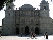
. Many of the attractions in the city proper are located between the main square or Zocalo and along Andador Macedonio Alcalà Street, known as the Andador Turístico or Tourist Walkway. These include the Cathedral, the Basilica of Nuestra Señora de la Soledad
, Museum of Contemporary Art (MACO), Rufino Tamayo Museum and the Mercado 20 de Noviembre Market, known for its food stands. The most important annual festival is the Guelaguetza
, also called the Fiesta del Lunes del Cerro (Festival of Mondays at the Mountain) which occurs each July.
The largest and most important archeological site is Monte Albán
, which was capital of the Zapotec empire. Also important as an archaeological site is the ancient Zapotec center of Mitla
at the eastern end of the Central Valleys which is noted for its unique ancient stone fretwork
and abstract mosaics. Between Mitla and Monte Albán there are a number of other important archeological sites such as Yagul
, Dainzú
and Lambiteyco.The most important of these three is Lambiteyco, in the middle of the Tlacolula Valley. It was occupied from 600 BCE to 800 CE and coincides with Monte Alban. It was important at that time for its production of salt. Yagul is a ceremonial center on the side of a mountain. Features include a Mesoamerican ball court, the La Rana courtyard,a temple, palace and other buildings.
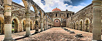 Other attractions in the area include colonial constructions such as the monasteries in Cuilapan, Tlaxiaco, Coixthlahuaca, Yanhuitlán and Santo Domingo. Churches include the Cathedral in Oaxaca and the main church of Teposcolula. Hierve el Agua
is an area with “petrified” waterfalls, where water with extremely high mineral content falls over the side of cliffs, forming stone waterfall-like structures. The name means “boil the water” but the water is not hot; rather it pushes up from the ground in places which looks like water boiling. Santa María del Tule
is home to an enormous Montezuma cypress (Taxodium mucronatum
) tree which is over 2,000 years old. The town of Zaachila
is known for its archeological site and weekly market.
The second most important zone for tourism is the coast especially from Puerto Escondido to Huatulco
, with sandy beaches on the Pacific Ocean, dolphins, sea turtles, and lagoons with water birds. Many beaches are nearly virgin with few visitors but several areas have been developed such as Puerto Escondido, Huatulco, Puerto Ángel
, Zipolite
, San Agustinillo
and Mazunte
. Puerto Escondido is an important destination for tourism from within Mexico with beaches such as Playa Carrizillo and also attracts international surfers to Zicatela Beach, where an annual surfing competition is held. There are also areas of Oaxaca that are promoted for ecotourism such as Lagunas de Chacahua National Park
set in 14,267 hectares of lagoons, rivers, beaches, mangroves, rainforest and grasslands with some 136 species of birds, 23 of reptiles, 4 amphibians and twenty types of mammals.
Yagul Natural Monument
, located in the Tlacolula Valley, 35 km to the east of Oaxaca city, was a settlement in the early part of the Monte Alban 1 Period (500 AD). It flourished as an urban centre, following the abandonment of Monte Alban around 800 BCE. However, even Yagul was abandoned for a brief period, before it became a city-state in Oaxaca. This status continued until the Spanish Conquistadores invaded the valley, which was then a settlement of Zapotecs. The fortified complex is laid out in three zones; the central part approached through a series of steps is a built-up platform that leads to the temples and palaces. It has the largest ball court in the valley and stated to be the largest in the Mesoamerican region. The palace of the rulers is an enormous monolith with six porticos and several entrances, built in stone and clay and covered with stucco. The main tomb has a stone façade, which is beautified with carved human heads and features hieroglyphic motifs on the door slab on both sides. To the south of the Palace of the Six Porticos, there is a narrow street that is paved with stone mosaics extracted from the nearby mountain. The street terminates in to a long, narrow room called the 'Sala de Consejo' (Council Chamber).
. Handcrafted items here are noted for their variety and quality. Oaxacan handcrafts are traditionally made with wood, wool, clay and leather and are sold in many venues from local tianguis
markets to upscale international stores. The best-known wood craft is the making of “alebrije
” figures, which are usually miniature, brightly colored real or imaginary animals. These were originally created from paper and cardboard in Mexico City, but this craft was adapted to native Oaxacan woodcarving to the form it has today. Carver Manuel Jiménez
of Arrazola
is credited with the creating of the Oaxacan version of this craft. Other wood crafts include the making of masks, toys and utensils. Major woodcarving areas include San MartínTilcajete and Arrazola.
Pottery has a long tradition that extends far back into the pre-Hispanic period. Oaxaca shares many pottery types with other parts of Mexico along with two of its own tradition: barro negro and the green glazed pottery of Atzompa
. The first is centered in the town of San Bartolo Coyotepec
near the capital city. This pottery gets its color from the local clay used to make it and its shine from a technique developed by Doña Rosa Nieto in the mid 20th century. The Atompa green-glazed ware is made much the same way it was in colonial times, although there have been some recent innovations with color and decorative techniques. This pottery is found in Santa María Atzompa
, also near Oaxaca city.
Another major craft category is textiles. Textiles from cotton and other fibers date back to early in the pre-Hispanic period on backstrap looms. This form of weaving has been dominated by women since that time. The Spanish introduced the wide European frame loom, which is mostly used by men. Traditional clothing items such as huipil
s are still made on backstrap looms, while the European looms are used to produce larger and heavier items such as rugs, ponchos and blankets. Most items are produced with cotton or wool fibers, although some maguey fibers can be found and palm fronds are used to produce mats and hats. Embroidery is an important part of indigenous clothing, especially for women. One municipality noted for its indigenous and embroidered clothing is Santo Tomás Jalietza, just south of the city of Oaxaca. The Xochimilco neighborhood of the capital is known for its embroidered tablecloths, napkins and other tableware.
Both precious and non-precious metals are worked in the state. Many gold and silver jewelry items are made with filigree
(fine metal thread) which is weaved and wrapped into shapes. This technique is Arab in origin and was introduced by the Spanish. The municipalities of Santo Domingo Tehuantepec, Juchitán de Zaragoza
and Huajuapan de León
are known for this work. Other metals, especially iron, are forged into utilitarian and decorative items in places such as Santiago Jamiltepec
and Tlacolula de Matamoros
. Items produced include mirrors, frames, figures, knives, machetes and more.
Concerning the general population, most of those aged 15 years or older have finished primary school, but completion of secondary school is well below the national average. Just over 21% of the population is illiterate, above the national average of 12.4%. 45% of those over 15 years of age have not finished primary school. Only a small minority of the population has professional aspirations with 6.7% attaining studies at the bacchelaurate level or above.
 Higher level education in Oaxaca has traditionally been limited to a few schools, although this is changing. The largest university in the state is the Benito Juárez Autonomous University of Oaxaca (UABJO), located in the capital city of Oaxaca de Juarez. Founded in 1827 as the Oaxacan Institute for Arts and Sciences, today UABJO offers the widest range of curricula in the state. In addition standard undergraduate studies, specialized schools such as the UABJO School of Medicine and UABJO School of Law offer advanced academic degree
s (i.e. Juris Doctorate, M.D., PhD) in their respective fields. Other universities the Instituto Tecnológico de Oaxaca
, which offers several undergraduate and graduate level programs, and the Universidad de la Sierra Juárez
, which was opened in 2005 to help provide higher education to underserved rural areas in the Sierra Juarez mountains.
In addition there is the SUNEO university system. Two of the largest institutions of this system are the Universidad Tecnológica de la Mixteca (UTM) and the Universidad del Mar (UMAR). The first offers bachelor's, master's and postgraduate courses in the areas of computing, electronics, design and business studies, while the second offers undergraduate and master's degrees in the areas of social sciences and marine sciences.
; Seguridad Social, ISSSTE and that related to PEMEX
.(infraes) The state sponsors the Servicios de Salud de Oaxaca (SSO) which primarily works to provide antibiotics and other medicines to public dispensaries. It is meant to supplement other federal and state services such as IMSS. There are 1,020 primary care medical facilities and 28 hospitals in the state, 3,240,024 people are registered in one or more government programs and are attended by 3,337doctors, 5,400 paramedics and 6,887 other health providers. Hospital Regional de Alta Especialidad de Oaxaca was constructed by the federal government as the first “level three” or high level specialty hospital in the state. It was opened in 2006 and is located in San Bartolo Coyotepec.
One particular health problem the state has is outbreaks of dengue fever
during the rainy season, which occurs from June to October. Some of these cases are hemorrhagic
. The problem is more severe in the tropical lowlands of the state, near the ocean.
Despite the health services that exist, there are serious problems and deficiencies. As of 1997, life expectancy in the state was 71.5 years, 9 years higher than in 1990. The death rate has decreased from 5.79 deaths per thousand to 5.14. While much of Mexico’s health care system struggles to meet needs, the system in Oaxaca, one of the country’s poorest states, has it particularly bad. The relatively prosperous state of Nuevo León
has 3,207 hospital beds, while Oaxaca has only 1,760, despite the fact that the two states have about the same population. There is about the same ratio of doctors between the two states. Forty four percent of pregnant women receive pre-natal care from people who are not medically qualified. 70 women each year die from complications from pregnancy and childbirth, and most of these are avoidable, due to bleeding and eclampsia
. For every 100,000 live births in Oaxaca, there are 95.1 maternal deaths, over the national average of 63.3, putting the state in the top five.
The state lacks sufficient numbers of health care workers and lacks specialized hospital and other facilities. Other problems include obsolete medical equipment, lack of medicines. Many of these problems have persisted for decades. Health care providers offer an average of 20,000 consults each day, covering a population of 800,000 people. In 2000, there was only one doctor for every 180 people.
In 2006, health care workers held a work stoppage and march, demanding improvements in the health care system along with the ouster of Governor Ulises Ruiz Ortiz
. Most of the participating strikers were from the hospital and emergency room sectors, from 15 hospitals and 650 health centers in the state.
. The baseball team, Guerreros de Oaxaca, play at the Eduardo Vasconcelos Stadium in Oaxaca de Juarez and play in the Mexican League. The Oaxacan Academy of Baseball is located in the municipality of San Bartolo Coyotepec. It was created in 2009 by Alfredo Harp Helú, owner of the Diablos Rojos and Guerreros de Oaxaca teams. The goal of the academy is to reach youth people through sports and education, especially those who show talent for the sport of baseball. Vinicio Castilla is the most notable player hailing from Oaxaca, having played third base in Major League Baseball
for the Atlanta Braves
, Colorado Rockies
, Tampa Bay Devil Rays, Houston Astros
and San Diego Padres
. He became the owner of the Oaxaca Guerreros in 1995 and three years later they won the championship. Basketball is practiced in all of Oaxaca, mostly played during local festivals, especially in the Sierra Norte. The area also has a tournament with the Copa Juárez as the prize.
The best known beach in Puerto Escondido is Playa Zicatela, due to its fame as a surfing attraction. The “tubes” produced by the waves that come ashore here attract advanced and professional surfers from all over Mexico and internationally. The Torneo Internacional de Surf (International Surfing Tournament) is held here each year in November and is a world class event. It has attracted names such as Nathaniel Curran from the U.S., Cris Davison from Australia and Marco Polo from Brazil, with its 50,000 USD first prize.
Because of its geography and landscape, mountain biking is also common in Oaxaca and is practiced primarily in the Sierra Norte in Ixtlan de Juarez, San Antonio Cuajimoloyas, Santa Catarian Ixtepeji, Benito Juarez Lachatao and San Isidro Llano Grande. Surfing is common in places such as Huatulco Bay and Puerto Escondido, with the annual Zicatela beach tournament held in November. Snorkeling
and scuba diving
take place in Puerto Escondido, principally in Playa Carrizalillo and Playa Manzanillo, Playa Marinero and Puerto Angelito and at Huatulco. Sport fishing is common in Puerto Escondido and in Huatulco with tournaments held in November and May respectively. Anglers, catch sailfish, dorado, marlin and others. In Huajuapan de Leon there is a fishing tournament at the Yosocuta Dam in July; it is noted for its black bass
(lobina). Kayak
ing also takes places along the Copalita River
in Huatulco.
Nahuatl
Nahuatl is thought to mean "a good, clear sound" This language name has several spellings, among them náhuatl , Naoatl, Nauatl, Nahuatl, Nawatl. In a back formation from the name of the language, the ethnic group of Nahuatl speakers are called Nahua...
: Huaxyacac, IPA:/ʋaːsʃʲa'kakʰ/), officially Estado Libre y Soberano de Oaxaca (Free and Sovereign State of Oaxaca) is one of the 31 states which, along with the Federal District
Mexico City
Mexico City is the Federal District , capital of Mexico and seat of the federal powers of the Mexican Union. It is a federal entity within Mexico which is not part of any one of the 31 Mexican states but belongs to the federation as a whole...
, comprise the 32 federative entities of Mexico
Mexico
The United Mexican States , commonly known as Mexico , is a federal constitutional republic in North America. It is bordered on the north by the United States; on the south and west by the Pacific Ocean; on the southeast by Guatemala, Belize, and the Caribbean Sea; and on the east by the Gulf of...
. It is divided into 571 municipalities
Municipalities of Oaxaca
The Mexican state of Oaxacais made up of 571 municipalities —more than any other state....
; of which 418 (almost three quarters) are governed by the system of customs and traditions. Its capital city is Oaxaca de Juárez.
It is located in Southwestern Mexico
Southwestern Mexico
Southwestern Mexico is a region of Mexico, formed by the states of Chiapas, Guerrero and Oaxaca.Because of its population is mostly indigenous people, these states are famous for the deep roots of their traditions, holidays, crafts and great food...
. It is bordered by the states of Guerrero
Guerrero
Guerrero officially Estado Libre y Soberano de Guerrero is one of the 31 states which, with the Federal District, comprise the 32 Federal Entities of Mexico. It is divided in 81 municipalities and its capital city is Chilpancingo....
to the west, Puebla
Puebla
Puebla officially Estado Libre y Soberano de Puebla is one of the 31 states which, with the Federal District, comprise the 32 Federal Entities of Mexico. It is divided in 217 municipalities and its capital city is Puebla....
to the northwest, Veracruz
Veracruz
Veracruz, formally Veracruz de Ignacio de la Llave officially Estado Libre y Soberano de Veracruz de Ignacio de la Llave , is one of the 31 states that, along with the Federal District, comprise the 32 federative entities of Mexico. It is divided in 212 municipalities and its capital city is...
to the north, Chiapas
Chiapas
Chiapas officially Estado Libre y Soberano de Chiapas is one of the 31 states that, with the Federal District, comprise the 32 Federal Entities of Mexico. It is divided in 118 municipalities and its capital city is Tuxtla Gutierrez. Other important cites in Chiapas include San Cristóbal de las...
to the east. To the south, Oaxaca has a significant coastline on the Pacific Ocean.
The state is best known for its indigenous peoples and cultures. The most numerous and best known are the Zapotecs and the Mixtecs, but there are sixteen that are officially recognized. These cultures have survived better to the present than most others in Mexico due to the state’s rugged and isolating terrain. Most live in the Central Valleys region, which is also an important area for tourism, attracting people for its archeological sites such as Monte Albán
Monte Albán
Monte Albán is a large pre-Columbian archaeological site in the Santa Cruz Xoxocotlán Municipality in the southern Mexican state of Oaxaca...
, native culture and crafts. Another important tourist area is the coast, which has the major resort of Huatulco
Huatulco
Huatulco , centered on the town of La Crucecita, is a tourist development in Mexico. It is located on the Pacific coast in the state of Oaxaca. Huatulco's tourism industry is centered on its nine bays thus the name Bahias de Huatulco but has since been unofficially shortened to simply Huatulco...
. The state also has some of the greatest biodiversity in Mexico.
Name
The name of the state comes from the name of its capital city, Oaxaca. This name comes from the NahuatlNahuatl
Nahuatl is thought to mean "a good, clear sound" This language name has several spellings, among them náhuatl , Naoatl, Nauatl, Nahuatl, Nawatl. In a back formation from the name of the language, the ethnic group of Nahuatl speakers are called Nahua...
word “Huaxyacac”, which refers to a tree called a “guaje” (Leucaena leucocephala), found in area around the capital city. The name was originally applied to the Valley of Oaxaca
Valley of Oaxaca
The Valley of Oaxaca is a geographic region located within the modern day State of Oaxaca in southern Mexico. The valley, which is located within the Sierra Madre Mountains, is shaped like a distorted and almost upside-down “Y,” with each of its arms bearing specific names: the northwestern Etla...
by Nahuatl speaking Aztecs and passed on to the Spanish when they were accompanied by Aztecs in the conquest of the Oaxaca area. The modern state was created in 1824, and the state seal was designed by Alfredo Canseco Feraud and approved by the government of Eduardo Vasconcelos.
Pre-historic and pre-Hispanic period
Most of what is known about pre-historic Oaxaca comes from archeological work in the Central Valleys region. Evidence of human habitation dating back to about 11,000 years BCE has been found in the Guilá Naquitz cave near the town of MitlaSan Pablo Villa de Mitla
San Pablo de Mitla is a town and municipality in Mexico which is most famous for being the site of the Mitla archeological ruins.It is part of the Tlacolula District in the east of the Valles Centrales Region....
. This area was recognized as a UNESCO World Heritage site in 2010 in recognition for the "earliest known evidence of domesticated plants in the continent, while corn cob fragments from the same cave are said to be the earliest documented evidence for the domestication of maize." More finds of nomadic peoples date back to about 5000 BCE, with some evidence of the beginning of agriculture. By 2000 BCE, agriculture had been established in the Central Valleys region of the state, with sedentary villages. The diet developed around this time would remain until the Spanish Conquest, consisting primarily of harvested corn, beans, chocolate, tomatoes, chili peppers, squash and gourds. Meat was generally hunted and included tepescuintle
Paca
The Lowland Paca , also known as the Spotted Paca, is a large rodent found in tropical and sub-tropical America, from East-Central Mexico to Northern Argentina...
, turkey, deer, peccary
Peccary
A peccary is a medium-sized mammal of the family Tayassuidae, or New World Pigs. Peccaries are members of the artiodactyl suborder Suina, as are the pig family and possibly the hippopotamus family...
, armadillo
Armadillo
Armadillos are New World placental mammals, known for having a leathery armor shell. Dasypodidae is the only surviving family in the order Cingulata, part of the superorder Xenarthra along with the anteaters and sloths. The word armadillo is Spanish for "little armored one"...
and iguana
Iguana
Iguana is a herbivorous genus of lizard native to tropical areas of Central America and the Caribbean. The genus was first described in 1768 by Austrian naturalist Josephus Nicolaus Laurenti in his book Specimen Medicum, Exhibens Synopsin Reptilium Emendatam cum Experimentis circa Venena...
.
The oldest known major settlements, such as Yanhuitlán
Santo Domingo Yanhuitlán
Santo Domingo Yanhuitlán is a village and municipality in the state of Oaxaca, Mexico, located northeast of Oaxaca city.It is part of the Nochixtlán District in the southeast of the Mixteca Region.It is 2,140 meters above sea level...
and Laguna Zope are located in this area as well. The latter settlement is known for its small figures called “pretty women” or “baby face.” Between 1200 and 900 BCE, pottery was being produced in the area as well. This pottery has been linked with similar work done in La Victoria, Guatemala. Other important settlements from the same time period include Tierras Largas
Tierras Largas
Tierras Largas is a formative-period archaeological site located in the Etla arm in the Valley of Oaxaca in Mexico. It is considered to be one of the first villages where sedentism originated in the Oaxaca area. The name is Spanish for “Long Lands”....
, San José Mogote
San Jose Mogote
San José Mogote is a pre-Columbian archaeological site of the Zapotec, a Mesoamerican culture that flourished in the region of what is now the Mexican state of Oaxaca. A forerunner to the better-known Zapotec site of Monte Albán, San José Mogote was the largest and most important settlement in the...
and Guadalupe
Guadalupe Etla
Guadalupe Etla is a village and municipality in the Mexican state of Oaxaca. The municipality has a total area of 17.86 km ².Guadalupe Etla is part of the region of the central valleys of Oaxaca....
, whose ceramics show Olmec
Olmec
The Olmec were the first major Pre-Columbian civilization in Mexico. They lived in the tropical lowlands of south-central Mexico, in the modern-day states of Veracruz and Tabasco....
influence. The major native language family, Oto-Manguean
Oto-Manguean languages
Oto-Manguean languages are a large family comprising several families of Native American languages. All of the Oto-Manguean languages that are now spoken are indigenous to Mexico, but the Manguean branch of the family, which is now extinct, was spoken as far south as Nicaragua and Costa Rica.The...
, is thought to have been spoken in northern Oaxaca around 4400 BCE and to have evolved into nine distinct branches by 1500 BCE.
Historic events in Oaxaca as far back as the 12th century are described in pictographic codices painted by Zapotecs and Mixtecs in the beginning of the colonial period, but outside of the information that can be obtained through their study, little historical information from pre-colonial Oaxaca exist, and our knowledge of this period relies largely on archaeological remains. By 500 BCE, the central valleys of Oaxaca were mostly inhabited by the Zapotecs, with the Mixtecs on the western side. These two groups were often in conflict throughout the pre-Hispanic period. Archeological evidence indicates that between 750 and 1521, there may have been population peaks of as high as 2.5 million.
The Zapotecs were the earliest to gain dominance over the Central Valleys region. The first major dominion was centered in Monte Albán, which flourished from 500 BCE until 750 CE. At its height, Monte Albán
Monte Albán
Monte Albán is a large pre-Columbian archaeological site in the Santa Cruz Xoxocotlán Municipality in the southern Mexican state of Oaxaca...
was home to some 25,000 people and was the capital city of the Zapotec nation. It remained a secondary center of power for the Zapotecs until the Mixtecs overran it in 1325. The site contains a number of notable features including the Danzantes, a set of stone reliefs and the finding of fine quality ceramics.
Coixtlahuaca
Coixtlahuaca was a pre-Columbian Mesoamerican state in the Mixteca Alta . Coixtlahuaca was a multi-ethnic polity, inhabited by both Chochos and Mixtecs. In addition to the Chocho and Mixtec languages, Nahuatl was used as a lingua franca...
. The Zapotecs occupied a large region from Central Valleys region to the Isthmus of Tehuantepec. However, no major city state like Monte Albán arose again, with villages and city-states remaining small, between 1,000 and 3,000 people with a palace, temple, market and residences. In a number of cases, there were Mesoamerican ball courts as well. These and larger centers also functioned as military fortresses in time of invasion. Important Zapotec and Mixtec sites include Yagul
Yagul
Yagul is an archaeological site and former city-state associated with the Zapotec civilization of pre-Columbian Mesoamerica, located in the Mexican state of Oaxaca. The site was declared one of the country's four Natural Monuments on 13 October 1998. The site is also known locally as Pueblo Viejo ...
, Zaachila
Zaachila
Zaachila was a powerful Mesoamerican city in what is now Oaxaca, Mexico, 6 km from the city of Oaxaca. The city is named after Zaachila Yoo, the Zapotec ruler, in the late 14th and early 15th century. It is now an archaeological site...
, Inguiteria, Yanhuitlan, Tamazulapan, Tejupan, and Teposcolula. During nearly all of this time, these various entities were at war with one another, and faced the threat of Aztec expansion.
While the Zapotec remained dominant in many parts of the Central Valleys and into the Isthmus of Tehuantepec, the Mixtec were pushing into Zapotec territory, taking Monte Alban. In areas they conquered, they became prolific builders, leaving behind numerous and still unexplored sites. However, the conquest of the Central Valleys was never completed with pressure coming from the Aztecs in Tenochtitlan in the 14th and 15th centuries. The Zapotecs and Mixtecs both allied themselves and fought among themselves as they tried to maintain their lands and valuable trade routes between the high central plains of Mexico and Central America.
The first Aztecs arrived to the Oaxaca area in 1250, but true expansion into the region began in the 15th century. In 1457, Moctezuma I invaded the Tlaxiaco and Coixtlahuaca areas, gaining control, demanding tribute and establishing military outposts. These were Mixtec lands at first, pushing these people even further into Zapotec territory. Under Axayacatl
Axayacatl
Axayacatl was the sixth Aztec Emperor, a ruler of the Postclassic Mesoamerican Aztec Empire and city of Tenochtitlan, who reigned from 1469 to 1481.He is chiefly remembered for subjugating Tlatelolco, Tenochtitlan's sister city, in 1473....
and Tizoc
Tízoc
Tizocic or Tizocicatzin , usually known in English as Tizoc, was the seventh tlatoani of Tenochtitlan.-Biography:...
, the Aztec began to take control of trade routes in the area and part of the Pacific Coast. By this time, the Zapotec were led by Cosijoeza
Cosijoeza
Cosijoeza or Cocijoeza was the fourth ruler of the Zapotec kingdom of Zaachila from 1487 until his death in 1529. He led an alliance of Zapotecs and Mixtecs against the armies of the Aztecs....
with the government in Zaachila in the latter 15th century. Under Ahuitzotl, the Aztecs temporarily pushed the Zapotecs into Tehuantepec and established a permanent military base at Huaxyacac (Oaxaca city). The Aztecs were stopped only by the Spanish Conquest. These conquests would change most of the place names in parts of Oaxaca to those from the Nahuatl language. In 1486 the Aztecs established a fort on the hill of Huaxyácac (now called El Fortín), overlooking the present city of Oaxaca. This was the major Aztec military base charged with the enforcement of tribute collection and control of trade routes.
However, Aztec rule in Oaxaca would last only a little more than thirty years.
Colonial period
Moctezuma II
Moctezuma , also known by a number of variant spellings including Montezuma, Moteuczoma, Motecuhzoma and referred to in full by early Nahuatl texts as Motecuhzoma Xocoyotzin, was the ninth tlatoani or ruler of Tenochtitlan, reigning from 1502 to 1520...
had informed Hernán Cortés
Hernán Cortés
Hernán Cortés de Monroy y Pizarro, 1st Marquis of the Valley of Oaxaca was a Spanish Conquistador who led an expedition that caused the fall of the Aztec Empire and brought large portions of mainland Mexico under the rule of the King of Castile in the early 16th century...
that the area had gold. In addition, when Zapotec leaders heard about the Spanish conquest of the Aztec Empire, they sent an offer of an alliance. Several captains and representatives were sent to the area to explore the area, looking for gold, and routes to the Pacific to establish trade routes to Asian spice markets. The most prominent of Cortés’ captains to arrive here were Gonzalo de Sandoval
Gonzalo de Sandoval
Gonzalo de Sandoval was a Spanish conquistador in New Spain and briefly co-governor of the colony while Hernan Cortés was away from the capital .-Arrival in New Spain:Sandoval was the youngest of the lieutenants of Cortés. They arrived together in New Spain in 1519...
, Francisco de Orozco and Pedro de Alvarado
Pedro de Alvarado
Pedro de Alvarado y Contreras was a Spanish conquistador and governor of Guatemala. He participated in the conquest of Cuba, in Juan de Grijalva's exploration of the coasts of Yucatan and the Gulf of Mexico, and in the conquest of Mexico led by Hernan Cortes...
. They overcame the main Aztec military stronghold only four months after the fall of Tenochtitlan. Their reports about the area prompted Cortés to seek the title of the Marquis of the Valley of Oaxaca from the Spanish Crown.
The valley Zapotecs, the Mixtecs of the Upper Mixteca, the Mazatecas and the Cuicatecas, for the most part, choose not to fight the newcomers, instead negotiating to keep most of the old hierarchy but with ultimate authority to the Spanish. Resistance to the new order was sporadic and confined to the Pacific coastal plain, the Zapotec Sierra, the Mixe region and the Isthmus of Tehuantepec. The Mixes put the most resistance to intrusions on their lands. They not only resisted during the first decade or so of Spanish occupation, like other groups, but through the rest of the 16th century. The last major Mixe rebellion came in 1570, when they burned and looted Zapotec communities and threatened to destroy the Spanish presidio of Villa Alta. However, this rebellion was put down by the Spanish, in alliance with about 2,000 Mixtecs and Aztecs. From this point, the Mixe retreated far into the mountains to isolate themselves, where they are found today.
The first priest in the territory was Juan Diaz, who accompanied Francisco de Orozco and build the first church in what is now the city of Oaxaca. He was followed by Bartolome de Olmade and others who began the superficial conversion of a number of indigenous, including the baptism of Zapotec leader Cosijoeza. In 1528, the Dominicans settled in the city of Oaxaca, forming the Bishopric of Oaxaca in 1535, and began to spread out from there, eventually reaching Tehuantepec and the coast. Other orders followed such as the Jesuits in 1596, the Mercedarians in 1601, and others in the 17th and 18th centuries.
Spanish conquest and subsequent colonization had a devastating effect on the native population, due to European diseases and forced labor. In some areas the native population nearly or completely disappeared. It has been estimated that the native population of the region declined from 1.5 million in 1520 to 150,000 in 1650. Eventually, this would prompt the Spanish to import African slaves to some regions of the state, mostly in the Costa Chica
Costa Region, Oaxaca
The Costa Region or Costa Chica lies on the Pacific coast of the state of Oaxaca, Mexico, below the more mountainous Sierra Sur inland from the coast...
. This poor treatment of indigenous and African populations would continue though the colonial period. Initially, the Spanish did not change native power structures and allowed nobles to keep their privileges as long as they were loyal to the Spanish crown. However, all indigenous were eventually lumped into the category as the Spanish halted warfare among the city-states and creating the official category of “indio” (Indian).
Settlers arriving from Spain brought with them domestic animals that had never been seen in Oaxaca: horses, cows, goats, sheep, chickens, mules and oxen. New crops such as sugar cane, vanilla and tobacco were introduced. However, landholding still remained mostly in indigenous hands, in spite of the fact that only 9% of Oaxaca’s terrain is arable. Spanish official and merchants would try to take indigenous privileges due to their social status, but this was resisted. While some of this was violent, the dominant response was to resort to the administrative-judicial system or yield. Violence was reserved for the worst of situations. One native product to reach economic importance during the colonial period was the cochineal
Cochineal
The cochineal is a scale insect in the suborder Sternorrhyncha, from which the crimson-colour dye carmine is derived. A primarily sessile parasite native to tropical and subtropical South America and Mexico, this insect lives on cacti from the genus Opuntia, feeding on plant moisture and...
insect, used for the making of dyes for textiles. This product was exported to Europe, especially in the 17th and 18th centuries. The use of this insect faded in the 19th century with the discovery of cheaper dyes.
For much of the colonial period, the state (then an intendencia or province) was relatively isolated with few roads and other forms of communication. Most politics and social issues were strictly on the local level. Despite Spanish domination, the indigenous peoples of Oaxaca have to maintain much of their culture and identity, more so than most other places in Mexico. Part of this is due to the geography of the land, making many communities isolated.
Independence
Mestizo
Mestizo is a term traditionally used in Latin America, Philippines and Spain for people of mixed European and Native American heritage or descent...
s or mixed indigenous/European. During the Mexican War of Independence
Mexican War of Independence
The Mexican War of Independence was an armed conflict between the people of Mexico and the Spanish colonial authorities which started on 16 September 1810. The movement, which became known as the Mexican War of Independence, was led by Mexican-born Spaniards, Mestizos and Amerindians who sought...
the government of this area remained loyal to the Spanish Crown. When representatives of Miguel Hidalgo y Costilla came to meet with them, they were hanged and their heads left out in view. Some early rebel groups emerged in the state, such as those led by Felipe Tinoco and Catarino Palacios, but they were also eventually executed. After 1812, insurgents began to have some success in the state, especially in the areas around Huajuapan de León, where Valerio Trujano defended the city against royalist forces until José María Morelos y Pavón was able to come in with support to keep the area in rebel hands. After that point, insurgents had greater success in various parts of the state, but the capital remained in royalist hands until the end of the war.
The state was initially a department after the war ended in 1821, but after the fall of emperor Agustín de Iturbide
Agustín de Iturbide
Agustín Cosme Damián de Iturbide y Aramburu , also known as Augustine I of Mexico, was a Mexican army general who built a successful political and military coalition that was able to march into Mexico City on 27 September 1821, decisively ending the Mexican War of Independence...
, it became a state in 1824 with Jose Maria Murguia named as its first governor.
During the 19th century, Oaxaca and the rest of Mexico was split between liberal (federalist) and conservative (centralist) factions. The political and military struggles between the factions resulted in wars and intrigues. Vicente Guerrero
Vicente Guerrero
Vicente Ramón Guerrero Saldaña was one of the leading revolutionary generals of the Mexican War of Independence, who fought against Spain for independence in the early 19th century, and served briefly as President of Mexico...
, a liberal, was executed by firing squad in Cuilapam
Cuilapan de Guerrero
Cuilapan de Guerrero is a town and municipality located in the central valley region of Oaxaca in southern Mexico. It is to the south of the capital city of Oaxaca on the road leading to Villa de Zaachila, and is in the Centro District in the Valles Centrales region.Cuilapan, originally called...
in 1831. Liberal Manuel Gomez Pedraza became governor in 1832 but was opposed by General Estaban Moctezuma. He and commandant Luis Quintanar persecuted liberals in the state, including Benito Juárez
Benito Juárez
Benito Juárez born Benito Pablo Juárez García, was a Mexican lawyer and politician of Zapotec origin from Oaxaca who served five terms as president of Mexico: 1858–1861 as interim, 1861–1865, 1865–1867, 1867–1871 and 1871–1872...
. The constant warfare had a negative effect on the state’s economy and those in the Tehuantepec area supported a separatist movement which was partially successful in the 1850s.
Two Oaxacans, Benito Juarez and Porfirio Díaz
Porfirio Díaz
José de la Cruz Porfirio Díaz Mori was a Mexican-American War volunteer and French intervention hero, an accomplished general and the President of Mexico continuously from 1876 to 1911, with the exception of a brief term in 1876 when he left Juan N...
were prominent players in the Reform War
Reform War
The Reform War in Mexico is one of the episodes of the long struggle between Liberal and Conservative forces that dominated the country’s history in the 19th century. The Liberals wanted a federalist government, limiting traditional Catholic Church and military influence in the country...
. It is difficult to overstate Juárez’s meaning to the state. He was born on March 21, 1806 in the village of San Pablo Guelatao
San Pablo Guelatao
San Pablo Guelatao is a town in the Mexican state of Oaxaca and the seat of the municipality of Guelatao de Juárez, about 55 km north of the city of Oaxaca...
and was full blooded Zapotec. He began his career studying to be a priest then a lawyer. In 1847, Juarez became governor of Oaxaca, but still faced stern opposition from conservatives such as Lope San Germán. With the success of the Plan de Ayutla, Juarez became governor again, and worked to remove privileges and properties from the Church and landed classes. The Constitution of 1857, was ratified in Oaxaca city, and Juarez left the governor’s position to become President of Mexico
President of Mexico
The President of the United Mexican States is the head of state and government of Mexico. Under the Constitution, the president is also the Supreme Commander of the Mexican armed forces...
. He was president during one of Mexico’s most turbulent times, fighting invading French forces and conservatives. As a liberal, he imposed many of the reforms which remain today including those in education and separation of church and state. He is also considered to be a legend and a symbol for the indigenous population of the state.
Porfirio Díaz was Juárez’s ally through the French Intervention
French intervention in Mexico
The French intervention in Mexico , also known as The Maximilian Affair, War of the French Intervention, and The Franco-Mexican War, was an invasion of Mexico by an expeditionary force sent by the Second French Empire, supported in the beginning by the United Kingdom and the Kingdom of Spain...
. French imperial forces took Oaxaca city, which was defended by Porfirio Diaz, landing the latter in prison. The capital was later recaptured by the liberals under Carlos Oronoz. However, soon after Juarez took back the presidency, Porfirio Diaz declared rebellion against him from Oaxaca in 1872 under the Plan de Tuxtepec. Juárez died in office.(bjarezgob) Diaz would succeed in obtaining the presidency and did not relinquish it until the Mexican Revolution
Mexican Revolution
The Mexican Revolution was a major armed struggle that started in 1910, with an uprising led by Francisco I. Madero against longtime autocrat Porfirio Díaz. The Revolution was characterized by several socialist, liberal, anarchist, populist, and agrarianist movements. Over time the Revolution...
.
Late 19th century to present
After the Mexican Revolution broke out, Diaz was soon ousted and the rest of the war was among the various factions that had power in different parts of the country. Various leaders such as Francisco I. Madero
Francisco I. Madero
Francisco Ignacio Madero González was a politician, writer and revolutionary who served as President of Mexico from 1911 to 1913. As a respectable upper-class politician, he supplied a center around which opposition to the dictatorship of Porfirio Díaz could coalesce...
, Victoriano Huerta
Victoriano Huerta
José Victoriano Huerta Márquez was a Mexican military officer and president of Mexico. Huerta's supporters were known as Huertistas during the Mexican Revolution...
and Venustiano Carranza
Venustiano Carranza
Venustiano Carranza de la Garza, was one of the leaders of the Mexican Revolution. He ultimately became President of Mexico following the overthrow of the dictatorial Huerta regime in the summer of 1914 and during his administration the current constitution of Mexico was drafted...
came to the state during this time. However; the most important force in the area was the Liberation Army of the South
Liberation Army of the South
The Liberation Army of the South was an armed group formed and led by Emiliano Zapata that took part in the Mexican Revolution. The force was commonly known as the Zapatistas....
under Emiliano Zapata
Emiliano Zapata
Emiliano Zapata Salazar was a leading figure in the Mexican Revolution, which broke out in 1910, and which was initially directed against the president Porfirio Díaz. He formed and commanded an important revolutionary force, the Liberation Army of the South, during the Mexican Revolution...
. This army would ally and fight against the previous leaders, especially Venustiano Carranza, and hold various portions of the state until 1920. At the end of the Revolution, a new state constitution was written and accepted in 1922.
A series of major disasters occurred in the state from the 1920s to the 1940s. In 1928, a serious of earthquakes destroyed many of the buildings in the capital. A much larger earthquake in 1931, was the largest in the state’s history, devastating a number of cities along the coast. The 1930s brought the Great Depression
Great Depression
The Great Depression was a severe worldwide economic depression in the decade preceding World War II. The timing of the Great Depression varied across nations, but in most countries it started in about 1929 and lasted until the late 1930s or early 1940s...
, which along with the disasters, prompted wide scale migration to Mexico City. In 1944, torrential rains caused massive flooding in the Tuxtepec region, causing hundreds of deaths.
In the 1940s and 1950s, new infrastructure projects were begun. These included the Izúcar-Tehuantepec section of the Panamerican Highway and the construction of the Miguel Alemán Dam. From the 1980s to the present, there has been much development of the tourism industry in the state. This tourism, as well as the population growth of the capital, prompted the construction of the Oaxaca-Mexico City highway in 1994. Development of tourism has been strongest in the Central Valleys area surrounding the capital, with secondary developments in Huatulco
Huatulco
Huatulco , centered on the town of La Crucecita, is a tourist development in Mexico. It is located on the Pacific coast in the state of Oaxaca. Huatulco's tourism industry is centered on its nine bays thus the name Bahias de Huatulco but has since been unofficially shortened to simply Huatulco...
and other locations along the coast. This development was threatened by the violence associated with the 2006 uprising
2006 Oaxaca protests
The Mexican state of Oaxaca was embroiled in a conflict that lasted more than seven months and resulted in at least seventeen deaths and the occupation of the capital city of Oaxaca by the Popular Assembly of the Peoples of Oaxaca . The conflict emerged in May 2006 with the police responding to a...
, which severely curtailed the number of incoming tourists for several years.
On February 12, 2008, a 6.4 magnitude earthquake was recorded in Oaxaca.
From the Mexican Revolution until the 2000s, the ruling PRI party held control of almost all of Oaxacan politics from the local to the state level. Challenges to the rule were sporadic and included the student movements of the 1970s, which did bring down the state government. Teachers’ strikes had been frequent since then, culminating in the 2006 uprising in Oaxaca city, which brought in groups protesting the heavy marginalization of the poor. The PRI
Institutional Revolutionary Party
The Institutional Revolutionary Party is a Mexican political party that held power in the country—under a succession of names—for more than 70 years. The PRI is a member of the Socialist International, as is the rival Party of the Democratic Revolution , making Mexico one of the few...
lost its 80-year hold on the state government in 2010 with the election of the PAN
National Action Party (Mexico)
The National Action Party , is one of the three main political parties in Mexico. The party's political platform is generally considered Centre-Right in the Mexican political spectrum. Since 2000, the President of Mexico has been a member of this party; both houses have PAN pluralities, but the...
gubernatorial candidate Gabino Cué Monteagudo
Gabino Cué Monteagudo
Gabino Cué Monteagudo is a Mexican politician. He is current governor of the state of Oaxaca, and the first non-PRI winning candidate in the state in 80 years. He previously ran for governor in 2004, losing to Ulises Ruiz Ortiz, the PRI-candidate and current outgoing state governor...
. This has led to speculation of major changes for the state.
Geography
The state is located in the south of Mexico, bordered by the states of Puebla, Veracruz, Chiapas and Guerrero with the Pacific Ocean to the south. It has a territory of 93967 km² (36,281 sq mi), accounting for less than 5% of Mexico’s territory. Here several mountain chains come together, with the elevation varying from sea level to 3759 m (12,333 ft) aslAbove mean sea level
The term above mean sea level refers to the elevation or altitude of any object, relative to the average sea level datum. AMSL is used extensively in radio by engineers to determine the coverage area a station will be able to reach...
, averaging at 1500 m (4,921 ft) asl. Oaxaca has one of the most rugged terrains in Mexico, with mountain ranges that abruptly fall into the sea. Between these mountains are mostly narrow valleys, canyons and ravines. Major elevations in the state include Cempoaltepetl (3396 m (11,142 ft) asl), El Espinazo del Diablo, Nindú Naxinda Yucunino and Cerro Encantado. Oaxaca’s has 533 km (331 mi) of coastline with nine major bays.
The mountains are mostly formed by the convergence of the Sierra Madre del Sur
Sierra Madre del Sur
The Sierra Madre del Sur is a mountain range in southern Mexico, extending from southern Michoacán east through Guerrero, to the Istmo de Tehuantepec in eastern Oaxaca.-Geography:...
, the Sierra Madre de Oaxaca
Sierra Madre de Oaxaca
The Sierra Madre de Oaxaca is a mountain range in southern Mexico. It begins at Pico de Orizaba and extends in a southeasterly direction for 300 km until reaching the Isthmus of Tehuantepec...
and the Sierra Atravesada into what is called the Oaxaca Complex (Complejo Oaxaqueño). The Sierra Madre del Sur runs along the coast with an average width of 150 km (93 mi) and a minimum height of 2000 metres (6,562 ft) asl with peaks over 2500 m (8,202 ft) asl. In various regions, the chain is locally known by other names, such as the Sierra de Miahuatlán and the Sierra de la Garza. The Sierra Madre de Oaxaca enters the state from the Puebla and Veracruz borders in the Tuxtepec region
Tuxtepec District, Oaxaca
Tuxtepec District is located in the north of the Papaloapan Region of the State of Oaxaca, Mexico.-Municipalities:The district includes the following municipalities:*Acatlán de Pérez Figueroa*Ayotzintepec*Cosolapa*Loma Bonita*San Felipe Jalapa de Díaz...
, running northwest to southeast towards the Central Valleys region
Valles Centrales de Oaxaca
The Valles Centrales is a region in the heart of the state of Oaxaca, Mexico.It includes the districts of Etla, Centro, Zaachila, Zimatlán, Ocotlán, Tlacolula and Ejutla...
, then onto the Tehuantepec area
Tehuantepec District, Oaxaca
Tehuantepec District is located in the west of the Istmo Region of the State of Oaxaca, Mexico.It includes the cities of Salina Cruz and Tehuantepec.-Municipalities:The district includes the following municipalities:...
. Local names for parts of this range include Sierra de Tamazulapan, Sierra de Nochixtlan, Sierra de Huautla, Sierra de Juárez, Sierra de Ixtlan and others. Average altitude is 2500 m (8,202 ft) asl with peaks over 3000 m (9,843 ft) asl and width averages at about 75 km (47 mi). The Sierra Atravesada is a prolongation of the Sierra Madre de Chiapas
Sierra Madre de Chiapas
Sierra Madre is a mountain range which runs northwest-southeast from the state of Chiapas in Mexico across Guatemala and into El Salvador and Honduras. Most of the volcanoes of Guatemala are a part of this range.A narrow coastal plain lies south the range, between the Sierra Madre and the Pacific...
. This range is not as high as the other two with an average elevation of just over 600 metres (1,969 ft). Most of it is located in the Juchitán district
Juchitán District, Oaxaca
Juchitán District is located in the east of the Istmo de Tehuantepec region of the State of Oaxaca, Mexico, covering the southern part of a low lying corridor through the mountains that separates the Gulf of Mexico from the Pacific ocean....
running east-west.
The only valleys of any real size are the Central Valleys between Etla
Etla District, Oaxaca
Etla District is located in the north of the Valles Centrales Region of the State of Oaxaca, Mexico.-Municipalities:The district includes the following municipalities:*Guadalupe Etla*Magdalena Apasco*Nazareno Etla*Reyes Etla*San Agustín Etla...
and Miahuatlan
Miahuatlán District, Oaxaca
Miahuatlán District is located in the south of the Sierra Sur Region of the State of Oaxaca, Mexico.-Municipalities:The district includes the following municipalities:*Miahuatlán de Porfirio Díaz*Monjas*San Andrés Paxtlan*San Cristobal Amatlán...
, which contains the city of Oaxaca. Smaller populated valleys include Nochixtlan, Nejapa, Cuicatlan and Tuxtepec. Small mesas contain population centers such as Putla
Putla Villa de Guerrero
Putla Villa de Guerrero or simply Putla, is a town and municipality in the State of Oaxaca, Mexico.It is part of Putla District in the west of the Sierra Sur Region....
, Juxtlahuaca
Juxtlahuaca
Juxtlahuaca is a cave and archaeological site in the Mexican state of Guerrero containing murals linked to the Olmec motifs and iconography. Along with the nearby Oxtotitlán cave, Juxtlahuaca walls contain the earliest sophisticated painted art known in Mesoamerica, and only known example of...
, Tamazulapan
Santo Tomás Tamazulapan
Santo Tomás Tamazulapan is a village and municipality in the state of Oaxaca, Mexico, located about 105 km south of Oaxaca city. It is 1,700 meters above sea level, and is part of the Miahuatlán District in the south of the Sierra Sur Region....
, Zacatepec
San Martín Zacatepec
San Martín Zacatepec is a town and municipality in Oaxaca in south-western Mexico. The municipality covers an area of 76.55 km².It is part of the Huajuapan District in the north of the Mixteca Region....
, Tlaxiaco
Tlaxiaco
Tlaxiaco is a city, and its surrounding municipality of the same name, in the Mexican state of Oaxaca. It is located in the Tlaxiaco District in the south of the Mixteca Region, with a population of about 17,450. The city is formally known as Heroica Ciudad de Tlaxiaco in honour of a battle waged...
and Huajuapan
Huajuapan de leon
Heroica Ciudad de Huajuapan de León; in , meaning Place of Brave People) is a rural city with a surrounding municipality located in the northwestern part of the Mexican state of Oaxaca....
. The largest canyons in the state are those in the Cuicatlan area
Cuicatlan District, Oaxaca
Cuicatlán District is located in the northeast of the Cañada Region of the State of Oaxaca, Mexico.-Municipalities:The district includes the following municipalities:*Chiquihuitlán de Benito Juárez*Concepción Pápalo*San Andrés Teotilalpam...
and include the Cortés, Galicia and María in the municipality of Tlaxiaco. There are a very large number of small canyons as well as ravines and arroyos of all sizes.
The mountainous terrain allows for no navigable rivers; instead, there are a large number of smaller ones, which often change name from area to area. The continental divide passes through the state, meaning that there is drainage towards both the Gulf of Mexico and the Pacific Ocean. Most of the drainage towards the Gulf is represented by the Papaloapan
Papaloapan River
The Papaloapan River is one of the main rivers of the Mexican state of Veracruz. Its name is derived from the Nahuatl papalotl and apan ....
and Coatzacoalcos Rivers and their tributaries such as the Grande and Salado Rivers. Three rivers account for most of the water headed for the Pacific: the Mixteco
Mixteco River
-References:*Atlas of Mexico, 1975 .*The Prentice Hall American World Atlas, 1984.*Rand McNally, The New International Atlas, 1993....
, Atoyac and Tehuantepec River
Tehuantepec River
-References:* Atlas of Mexico, 1975 .* The Prentice Hall American World Atlas, 1984.* Rand McNally, The New International Atlas, 1993....
s with their tributaries. Other important rivers and streams include the Tequisistlán, Santo Domingo, Putla, Minas, Puxmetacán-Trinidad, La Arena, Cajonos, Tenango, Tonto, Huamelula, San Antonio, Ayutla, Joquila, Copalita, Calapa, Colotepec, Aguacatenango-Jaltepec, Los Perros, El Corte, Espíritu Santo, Sarabia, Ostuta, Petapa and Petlapa.
Regions, districts and major communities
Major cities include Huajuapan de LeónHuajuapan de leon
Heroica Ciudad de Huajuapan de León; in , meaning Place of Brave People) is a rural city with a surrounding municipality located in the northwestern part of the Mexican state of Oaxaca....
, Juchitán de Zaragoza
Juchitán de Zaragoza
Juchitán de Zaragoza is an indigenous town in the southeast of the Mexican state of Oaxaca.It is part of the Juchitán District in the west of the Istmo de Tehuantepec region...
, Oaxaca (Oaxaca de Juárez)
Oaxaca, Oaxaca
The city and municipality of Oaxaca de Juárez, or simply Oaxaca, is the capital and largest city of the Mexican state of the same name . It is located in the Centro District in the Central Valleys region of the state, in the foothills of the Sierra Madre at the base of the Cerro del Fortín...
, Puerto Escondido, Salina Cruz
Salina Cruz
Salina Cruz is a major seaport on the Pacific coast of the Mexican state of Oaxaca. It is the state's third-largest city and is municipal seat of the municipality of the same name.It is part of the Tehuantepec District in the west of the Istmo Region....
, San Pedro Pochutla
San Pedro Pochutla
San Pedro Pochutla is a city and municipality located in the south of Oaxaca state, Mexico next to the Pacific Ocean.It is an important commercial, transportation and administrative hub for the Pochutla District in the east of the Costa Region. Pochutla is located at the junction of coastal...
, San Juan Bautista Cuicatlan
San Juan Bautista Cuicatlan
San Juan Bautista Cuicatlan is a town and municipality in Oaxaca in south-western Mexico. The municipality covers an area of 543.5 km².It is part of Cuicatlán District in the north of the Cañada Region....
, San Juan Bautista Tuxtepec
San Juan Bautista Tuxtepec
San Juan Bautista Tuxtepec , or simply referred to as Tuxtepec, is the head of the municipality by the same name and is the second most populous city of the Mexican state of Oaxaca....
, Santa Cruz Xoxocotlán
Santa Cruz Xoxocotlán
Santa Cruz Xoxocotlán is a small city and municipality located 5 km from the state capital of Oaxaca in the south of Mexico.It is part of the Centro District in the Valles Centrales region....
, Santa Lucía del Camino
Santa Lucía del Camino
Santa Lucía del Camino is a city and its surrounding municipality located in the central part of the Mexican state of Oaxaca. It lies just 3 km east of the state capital city of Oaxaca, within the Oaxaca metropolitan area....
, Santa María Asunción Tlaxiaco
Tlaxiaco
Tlaxiaco is a city, and its surrounding municipality of the same name, in the Mexican state of Oaxaca. It is located in the Tlaxiaco District in the south of the Mixteca Region, with a population of about 17,450. The city is formally known as Heroica Ciudad de Tlaxiaco in honour of a battle waged...
, Santiago Pinotepa Nacional and Tehuantepec (Santo Domingo Tehuantepec)
Tehuantepec
Tehuantepec is a city and municipality in the southeast of the Mexican state of Oaxaca. It is part of the Tehuantepec District in the west of the Istmo Region. The area was important in pre Hispanic period as part of a trade route that connected Central America with what is now the center of...
.
Regions and districts of Oaxaca are:
| Region | District | Municipalities with 2005 population over 19,000 | Area (km2) | District population (2005) |
|---|---|---|---|---|
| Mixteca Mixteca Region, Oaxaca The Mixteca Region is a region in the state of Oaxaca, Mexico, part of the broader La Mixteca area which covers parts of the states of Puebla, Guerrero and Oaxaca.... |
Juxtlahuaca Juxtlahuaca District, Oaxaca Juxtlahuaca District is located in the southwest of the Mixteca Region of the State of Oaxaca, Mexico. The largest town is Santiago Juxtlahuaca.The district is at an average elevation of 1,690 meters above sea level, and has an area of 1,848 km2.... |
Santiago Juxtlahuaca Santiago Juxtlahuaca Santiago Juxtlahuaca is a town and municipality in Oaxaca in south-western Mexico.It is in the Juxtlahuaca District of the Mixteca Region.-Town:The town is at a height of 1,690 meters above sea level.... |
1,848 | 72,176 |
| Silacayoapam Silacayoapam District, Oaxaca Silacayoapam District is located in the northwest of the Mixteca Region of the State of Oaxaca, Mexico.The climate is temperate, with average temperature of 20.6°C... |
1,822 | 30,300 | ||
| Huajuapan Huajuapan District, Oaxaca Huajuapan District is located in the north of the Mixteca Region of the State of Oaxaca, Mexico. The principal city is Huajuapan de León.-Municipalities:The district includes the following municipalities:*Asunción Cuyotepeji*Cosoltepec... |
Huajuapan de León Huajuapan de leon Heroica Ciudad de Huajuapan de León; in , meaning Place of Brave People) is a rural city with a surrounding municipality located in the northwestern part of the Mexican state of Oaxaca.... |
3,270 | 122,760 | |
| Coixtlahuaca Coixtlahuaca District, Oaxaca Coixtlahuaca District is located in the northeast of the Mixteca Region of the State of Oaxaca, Mexico. As of 2005 the population was 9,018, down 2.8% from 2000.The region is generally from 2,000m to 3,000m high, mostly hilly or mountainous with small plains.... |
1,666 | 9,018 | ||
| Teposcolula Teposcolula District, Oaxaca Teposcolula District is located in the center of the Mixteca Region of the State of Oaxaca, Mexico.-Municipalities:The district includes the following municipalities:*Chilapa de Diaz*La Trinidad Vista Hermosa*San Andrés Lagunas... |
1,547 | 31,127 | ||
| Tlaxiaco Tlaxiaco District, Oaxaca Tlaxiaco District is located in the south of the Mixteca Region of the State of Oaxaca, Mexico. The main city is the Heroic City of Tlaxiaco-Municipalities:The district includes the following municipalities:*Chalcatongo de Hidalgo*Magdalena Peñasco... |
2,711 | 105,775 | ||
| Nochixtlán Nochixtlán District, Oaxaca Nochixtlán District is located in the southeast of the Mixteca Region of the State of Oaxaca, Mexico.The main city is Asunción Nochixtlán.-Municipalities:The district includes the following municipalities:*Asunción Nochixtlán*Magdalena Jaltepec... |
2,799 | 55,821 | ||
| Istmo Istmo de Tehuantepec, Oaxaca Istmo de Tehuantepec is the largest region in the state of Oaxaca, Mexico. It covers the southern part of the Isthmus of Tehuantepec, the shortest route between the Gulf of Mexico and the Pacific Ocean before the Panama Canal was opened.... |
Juchitán Juchitán District, Oaxaca Juchitán District is located in the east of the Istmo de Tehuantepec region of the State of Oaxaca, Mexico, covering the southern part of a low lying corridor through the mountains that separates the Gulf of Mexico from the Pacific ocean.... |
Juchitán de Zaragoza Juchitán de Zaragoza Juchitán de Zaragoza is an indigenous town in the southeast of the Mexican state of Oaxaca.It is part of the Juchitán District in the west of the Istmo de Tehuantepec region... Salina Cruz Salina Cruz Salina Cruz is a major seaport on the Pacific coast of the Mexican state of Oaxaca. It is the state's third-largest city and is municipal seat of the municipality of the same name.It is part of the Tehuantepec District in the west of the Istmo Region.... |
14,392 | 339,445 |
| Tehuantepec Tehuantepec District, Oaxaca Tehuantepec District is located in the west of the Istmo Region of the State of Oaxaca, Mexico.It includes the cities of Salina Cruz and Tehuantepec.-Municipalities:The district includes the following municipalities:... |
Tehuantepec Tehuantepec Tehuantepec is a city and municipality in the southeast of the Mexican state of Oaxaca. It is part of the Tehuantepec District in the west of the Istmo Region. The area was important in pre Hispanic period as part of a trade route that connected Central America with what is now the center of... |
6,305 | 222,710 | |
| Cañada Cañada, Oaxaca Cañada is a region in the state of Oaxaca, Mexico covering 4,300 square km. It includes two districts, Teotitlán and Cuicatlán.The main administrative center is Teotitlan de Flores Magon, but Huautla de Jimenez is considered the most important cultural center in the region.The region is named after... |
Teotitlán Teotitlán District, Oaxaca Teotitlán District is located in the north of the Cañada Region of the State of Oaxaca, Mexico.-Municipalities:The district includes the following municipalities:*Ejutla de Crespo*Eloxochitlán de Flores Magón*Huautepec... |
Huautla de Jiménez | 2,212 | 144,534 |
| Cuicatlán Cuicatlan District, Oaxaca Cuicatlán District is located in the northeast of the Cañada Region of the State of Oaxaca, Mexico.-Municipalities:The district includes the following municipalities:*Chiquihuitlán de Benito Juárez*Concepción Pápalo*San Andrés Teotilalpam... |
2,187 | 51,724 | ||
| Papaloapan Papaloapan Region, Oaxaca The Cuenca del Papaloapan Region is in the north of the state of Oaxaca, Mexico where the foothills of the Sierra Madre de Oaxaca meet the coastal plain of Veracruz.The principal city is San Juan Bautista Tuxtepec, the second largest in Oaxaca state.... |
Tuxtepec Tuxtepec District, Oaxaca Tuxtepec District is located in the north of the Papaloapan Region of the State of Oaxaca, Mexico.-Municipalities:The district includes the following municipalities:*Acatlán de Pérez Figueroa*Ayotzintepec*Cosolapa*Loma Bonita*San Felipe Jalapa de Díaz... |
San Juan Bautista Tuxtepec San Juan Bautista Tuxtepec San Juan Bautista Tuxtepec , or simply referred to as Tuxtepec, is the head of the municipality by the same name and is the second most populous city of the Mexican state of Oaxaca.... |
5,496 | 393,595 |
| Choapan Choapam District, Oaxaca Choapam District is located in the south of the Papaloapan Region of the State of Oaxaca, Mexico. The district has an area of 3,166 km2, and as of 2005 had a population of 37,809.... |
2,987 | 44,346 | ||
| Sierra Norte Sierra Norte de Oaxaca La Sierra Norte de Oaxaca is a heavily-wooded region in the state of Oaxaca, Mexico.It is 62 km from the city of Oaxaca on Federal highway 175, heading east towards Tuxtepec.... |
Ixtlán Ixtlán District, Oaxaca Ixtlán District is located in the northeast of the Sierra Norte region of the State of Oaxaca, Mexico.The district includes 26 municipalities, bringing together a total of 161 settlements which at the 2000 census had between them 40,218 inhabitants, the majority of them indigenous Zapotec... |
2,864 | 36,870 | |
| Villa Alta Villa Alta District, Oaxaca Villa Alta District is located in the center of the Sierra Norte Region of the State of Oaxaca, Mexico.It has an area of 1,156 km2 of mountainous country, divided into 25 municipalities.... |
1,156 | 29,009 | ||
| Mixe Sierra Mixe The Sierra Mixe or Mixes District is a district in the east of the Sierra Norte Region of the Mexican state of Oaxaca. It comprises 17 municipalities and covers 4,930 km2 at an average elevation of 1,200 meters above sea level.... |
San Juan Cotzocon San Juan Cotzocon San Juan Cotzocon is a town and municipality in Oaxaca in south-western Mexico.It is part of the Sierra Mixe district within the Sierra Norte de Oaxaca Region.The name "Cotzocón" or "Cozogón" means "Dark Mountain".-Environment:... |
4,930 | 96,920 | |
| Valles Centrales Valles Centrales de Oaxaca The Valles Centrales is a region in the heart of the state of Oaxaca, Mexico.It includes the districts of Etla, Centro, Zaachila, Zimatlán, Ocotlán, Tlacolula and Ejutla... |
Etla Etla District, Oaxaca Etla District is located in the north of the Valles Centrales Region of the State of Oaxaca, Mexico.-Municipalities:The district includes the following municipalities:*Guadalupe Etla*Magdalena Apasco*Nazareno Etla*Reyes Etla*San Agustín Etla... |
2,221 | 117,207 | |
| Centro Centro District, Oaxaca Centro District is located in the Valles Centrales Region of the State of Oaxaca, Mexico. The district includes the state capital Oaxaca and satellite towns.The district has an average elevation of 1,550 meters.... |
Oaxaca Oaxaca, Oaxaca The city and municipality of Oaxaca de Juárez, or simply Oaxaca, is the capital and largest city of the Mexican state of the same name . It is located in the Centro District in the Central Valleys region of the state, in the foothills of the Sierra Madre at the base of the Cerro del Fortín... Santa Cruz Xoxocotlán Santa Cruz Xoxocotlán Santa Cruz Xoxocotlán is a small city and municipality located 5 km from the state capital of Oaxaca in the south of Mexico.It is part of the Centro District in the Valles Centrales region.... Santa Lucía del Camino Santa Lucía del Camino Santa Lucía del Camino is a city and its surrounding municipality located in the central part of the Mexican state of Oaxaca. It lies just 3 km east of the state capital city of Oaxaca, within the Oaxaca metropolitan area.... Santa María Atzompa Santa María Atzompa Santa María Atzompa is a town and municipality located in the Mexican state of Oaxaca, about five km from the state capital of Oaxaca.It is part of the Centro District in the Valles Centrales region. The town was founded between the 7th and 9th centuries as a satellite of the ancient Zapotec city... |
539 | 515,440 | |
| Zaachila Zaachila District, Oaxaca Zaachila District is located in the west of the Valles Centrales Region of the State of Oaxaca, Mexico.The district includes the municipalities of San Antonio Huitepec, San Miguel Peras, San Pablo Cuatro Venados, Santa Inés del Monte, Trinidad Zaachila and Villa de Zaachila.... |
Villa de Zaachila Villa de Zaachila Villa de Zaachila is a town and municipality in Oaxaca, Mexico, six km from the city of Oaxaca.It is part of the Zaachila District in the west of the Valles Centrales Region... |
569 | 41,783 | |
| Zimatlán Zimatlán District, Oaxaca Zimatlán District is located in the west of the Valles Centrales Region of the State of Oaxaca, Mexico.-Municipalities:The district includes the following municipalities:*Ayoquezco de Aldama*Ciénega de Zimatlán*Magdalena Mixtepec*San Antonino El Alto... |
988 | 51,738 | ||
| Ocotlán Ocotlán District, Oaxaca Ocotlán District is located in the south of the Valles Centrales Region of the State of Oaxaca, Mexico.-Municipalities:The district includes the following municipalities:*Asunción Ocotlán*Magdalena Ocotlán*Ocotlán de Morelos... |
Ocotlán de Morelos Ocotlán de Morelos Ocotlán de Morelos is a town and municipality in the state of Oaxaca, about 35 km south of the center of the city of Oaxaca along Highway 175.... |
858 | 68,840 | |
| Tlacolula Tlacolula District, Oaxaca Tlacolula District is located in the east of the Valles Centrales Region of the State of Oaxaca, Mexico.-Municipalities:The district includes the following municipalities:*Magdalena Teitipac*Rojas de Cuauhtémoc*San Bartolomé Quialana... |
3,324 | 107,653 | ||
| Ejutla Ejutla District, Oaxaca Ejutla District is located in the south of the Valles Centrales Region of the State of Oaxaca, Mexico.-Municipalities:The district includes the following municipalities:*Coatecas Altas*Ejutla de Crespo*La Compañia*La Pe*San Agustín Amatengo... |
963 | 40,985 | ||
| Sierra Sur Sierra Sur de Oaxaca Sierra Sur is a region in the state of Oaxaca, Mexico. It includes the districts of Putla, Sola de Vega, Miahuatlán and Yautepec. Miahuatlán is the largest city.The region has 70 municipalities, some very poor, such as Zanizá, Amoltepec and Los Loxichas.... |
Putla Putla District, Oaxaca Putla District is located in the west of the Sierra Sur Region of the State of Oaxaca, Mexico.-Municipalities:The district includes the following municipalities:*Constancia del Rosario*La Reforma, Oaxaca*Mesones Hidalgo*Putla Villa de Guerrero... |
Putla Villa de Guerrero Putla Villa de Guerrero Putla Villa de Guerrero or simply Putla, is a town and municipality in the State of Oaxaca, Mexico.It is part of Putla District in the west of the Sierra Sur Region.... |
2,627 | 83,303 |
| Sola de Vega Sola de Vega District, Oaxaca Sola de Vega District is located in the Sierra Sur Region of the State of Oaxaca, Mexico.The district center is Villa Sola de Vega.-Municipalities:The district includes the following municipalities:*San Francisco Cahuacua*San Francisco Solá... |
3,592 | 74,107 | ||
| Miahuatlán Miahuatlán District, Oaxaca Miahuatlán District is located in the south of the Sierra Sur Region of the State of Oaxaca, Mexico.-Municipalities:The district includes the following municipalities:*Miahuatlán de Porfirio Díaz*Monjas*San Andrés Paxtlan*San Cristobal Amatlán... |
Miahuatlán de Porfirio Díaz Miahuatlán de Porfirio Díaz Miahuatlán de Porfirio Díaz is a town and municipality in Oaxaca in south-eastern Mexico. The municipality covers an area of 326.6 km², and is at an average elevation of 1,600 meters.It is part of the Miahuatlán District in the south of the Sierra Sur Region.... |
3,938 | 109,302 | |
| Yautepec Yautepec District, Oaxaca Yautepec District is located in the east of the Sierra Sur Region of the State of Oaxaca, Mexico.-Environment:The district lies in the eastern end of the Sierra Madre del Sur and is mountainous, with an area of 4,772 square kilometers.... |
4,559 | 31,070 | ||
| Costa Costa Region, Oaxaca The Costa Region or Costa Chica lies on the Pacific coast of the state of Oaxaca, Mexico, below the more mountainous Sierra Sur inland from the coast... |
Jamiltepec Jamiltepec District, Oaxaca Jamiltepec District is located in the west of the Costa Region of the State of Oaxaca, Mexico.-Municipalities:The district includes the following municipalities:*Mártires de Tacubaya*Pinotepa de Don Luis*Pinotepa Nacional*San Agustín Chayuco... |
Pinotepa Nacional Pinotepa Nacional Pinotepa Nacional is a city and seat of the municipality of the same name, in the Mexican state of Oaxaca.... |
4,293 | 170,249 |
| Juquila Juquila District, Oaxaca Juquila District is located in the center of the Costa Region of the State of Oaxaca, Mexico, on the Pacific coast.It has an area of 5,055 km2.As of 2005 it had a total population of 134,365 of whom 33,106 spoke an indigenous language.... |
San Pedro Mixtepec (Puerto Escondido) | 3,531 | 134,365 | |
| Pochutla Pochutla District, Oaxaca Pochutla District is located in the east of the Costa Region of the State of Oaxaca, Mexico. The primary city is San Pedro Pochutla.-Municipalities:The district includes the following municipalities:* Candelaria Loxicha* Pluma Hidalgo... |
San Pedro Pochutla San Pedro Pochutla San Pedro Pochutla is a city and municipality located in the south of Oaxaca state, Mexico next to the Pacific Ocean.It is an important commercial, transportation and administrative hub for the Pochutla District in the east of the Costa Region. Pochutla is located at the junction of coastal... Santa María Huatulco Santa María Huatulco Santa María Huatulco is a town and municipality in Oaxaca in south-western Mexico.It is part of the Pochutla District in the east of the Costa Region.... Santa María Tonameca Santa María Tonameca Santa María Tonameca is a town and municipality located on the southern coast of Oaxaca, Mexico, about 268 km from the capital city of Oaxaca.It is part of the Pochutla District in the east of the Costa Region.... |
3,773 | 174,649 | |
| 93,967 | 3,506,821 | |||
Climate
While the state is within the tropical latitudes, its climate varies with altitude. There are three principle climate regions in the state. The first is the hot and semi humid lands. This accounts for about 30% of the state. The next is the semi hot and semi humid regions which account for about 18%, and temperate and semi humid at about 16%. All of these climate experience a rainy season in the summer and early fall. As most of the state is over 2000 m (6,562 ft) above sea levelAbove mean sea level
The term above mean sea level refers to the elevation or altitude of any object, relative to the average sea level datum. AMSL is used extensively in radio by engineers to determine the coverage area a station will be able to reach...
, average temperature is about 18 °C (64.4 °F), except near the coast. The coastline along with the regions of Yautepec, Putla, parts of Huahuapan and Silacayoapan are hot and relatively dry. Hot and humid climates predominate in Villa Alta, and the Central Valleys area and all others over 2000 m (6,562 ft) above sea level have a temperate climate. A few of the highest peaks, such as those in Tehuantepec and Putla have a cold climate. Precipitation varies from between 430 to 2700 mm (16.9 to 106.3 in) per year. The Sierra Mazteca, Textepec and other areas near the Veracruz border have rains year round. The rest of the state receives the majority of its rain during the summer and early fall. The higher elevations can experience freezing temperatures in December and January.
Demographics
Overview
The state has a total population of about 3.5 million, with women outnumbering men by 150,000 and about 60% of the population under the age of 30. It is ranked tenth in population in the country. Fifty three percent of the population lives in rural areas. Most of the state’s population growth took place between 1980 and 1990. Life expectancy is 71.7 for men and 77.4 for women, just under the national average. Births far outpace deaths. In 2007, there were 122,579 birth and 19,439 deaths. Approximately 85% profess the Catholic faith.Indigenous peoples
Demographically, Oaxaca stands out due to the high percentage of indigenous peoples. It is estimated that at least a third are speakers of indigenous languages (with 5% not able to speak Spanish), accounting for 53% of Mexico’s total indigenous language speaking population. The state straddles two Mesoamerican cultural areas. The first extends into the state from the Mayan lands of Chiapas, YucatanYucatán
Yucatán officially Estado Libre y Soberano de Yucatán is one of the 31 states which, with the Federal District, comprise the 32 Federal Entities of Mexico. It is divided in 106 municipalities and its capital city is Mérida....
and Guatemala
Guatemala
Guatemala is a country in Central America bordered by Mexico to the north and west, the Pacific Ocean to the southwest, Belize to the northeast, the Caribbean to the east, and Honduras and El Salvador to the southeast...
. The northeast of the state is part of the cultures of the Valley of Mexico
Valley of Mexico
The Valley of Mexico is a highlands plateau in central Mexico roughly coterminous with the present-day Distrito Federal and the eastern half of the State of Mexico. Surrounded by mountains and volcanoes, the Valley of Mexico was a centre for several pre-Columbian civilizations, including...
, with historical influence seen from ancient cities such as Teotihuacan
Teotihuacan
Teotihuacan – also written Teotihuacán, with a Spanish orthographic accent on the last syllable – is an enormous archaeological site in the Basin of Mexico, just 30 miles northeast of Mexico City, containing some of the largest pyramidal structures built in the pre-Columbian Americas...
, Tula
Tula, Hidalgo
Tula, formally, Tula de Allende, is a town and one of the 84 municipalities of Hidalgo, in central-eastern Mexico. The municipality covers an area of 305.8 km² , and as of 2005, the municipality had a total population of 93,296, with 28,432 in the town...
and Tenochtitlan.
The main reason that indigenous languages and cultures have been able to survive here is the rugged terrain, which isolate communities. This also has the effect of dividing the state into small secluded communities, which have developed independently over time. There are 16 ethno linguistic groups recognized by the Instituto Nacional Indigenista who maintain their individual languages, customs and traditions well into the colonial period and to some extend to the present day. However, some studies put the number of cultures in the state as high as 4,000. This makes Oaxaca the most ethnically complex of Mexico’s 31 states.
The most populous indigenous groups in Oaxaca are the Zapotec or Mixtec
Mixtec
The Mixtec are indigenous Mesoamerican peoples inhabiting the Mexican states of Oaxaca, Guerrero and Puebla in a region known as La Mixteca. The Mixtecan languages form an important branch of the Otomanguean language family....
. Several other languages of the Oto-Manguean languages
Oto-Manguean languages
Oto-Manguean languages are a large family comprising several families of Native American languages. All of the Oto-Manguean languages that are now spoken are indigenous to Mexico, but the Manguean branch of the family, which is now extinct, was spoken as far south as Nicaragua and Costa Rica.The...
are spoken in Oaxaca: The Triques
Trique language
The Trique language is an Oto-Manguean language of Mexico spoken by the Trique indigenous group of the state of Oaxaca and elsewhere...
, Amuzgo
Amuzgo
Amuzgo is an Oto-Manguean language spoken in the Costa Chica region of the Mexican states of Guerrero and Oaxaca by about 44,000 speakers. Like other Oto-Manguean languages, Amuzgo is a tonal language. From syntactical point of view Amuzgo can be considered as an active language...
s and Cuicatec
Cuicatec
The Cuicatecs are an indigenous group of the Mexican state of Oaxaca, closely related to the Mixtecs. They inhabit two towns: Teutila and Tepeuxila in western Oaxaca...
s are linguistically most closely related to the Mixtecs, The languages of the Chocho
Chocho people
The Chochos are an indigenous people of the Mexican state of Oaxaca.-Language:Their traditional language, Chocho, is a member of the Popolocan branch of the Oto-Manguean language family. , it had 770 speakers. Chochos also speak Spanish, the dominant language of Mexico.The Chocho name for...
, Popoloca and Ixcatec peoples are most closely related to that of the Mazatecs. The Chatino language
Chatino language
The Chatino language is an indigenous Mesoamerican language, which is classified under the Zapotecan branch of the Oto-Manguean language family...
is grouped with the Zapotecan
Zapotecan languages
The Zapotecan languages are a group of related Oto-Manguean languages which descend from the common proto-Zapotecan language spoken by the Zapotec people during the era of the dominance of Monte Albán....
branch of Oto-Manguean. The languages of the Zoque
Zoque
The Zoque are an indigenous people of Mexico; they speak variants of the Zoque languages.This group consists of 41,609 people, according to the 2000 census...
and Mixe peoples belong to the Mixe–Zoquean languages. Other ethnic groups include the Chontalees, Chinantec
Chinantec
The Chinantecs are an indigenous people that live in Oaxaca and Veracruz, Mexico, especially in the districts of Cuicatlán, Ixtlán de Juárez, Tuxtepec and Choapan.The Chinantec languages belong to the Chinantecan branch of the Oto-Manguean family...
s, the Huaves
Huave people
The Huave are an indigenous people of Mexico. The autodenomination term used by the Huave themselves is Ikoots/Kunajts , or Mareños . They have inhabited the Isthmus of Tehuantepec for more than 3000 years, preceding the Zapotec people in settling the area...
and Nahuas. As of 2005, a total of 1,091,502 people were counted as speaking an indigenous language.
Zapotecs
The largest indigenous group in the state are the Zapotecs at about 350,000 people or about 31% of the total indigenous population. The Zapotec have an extremely long history in the Central Valleys region and unlike other indigenous groups, do not have a migration story. For them, they have always been here. Zapotecs have always called themselves Be'ena'a, which means The People. Zapotec territory extends in and around the Central Valleys region of the state, around the capital city of Oaxaca. The Zapotec language has historically been and is still the most widely spoken in the state, with four dialects that correspond to the four subdivisions of these people: Central Valleys and Isthmus, the Sierra de Ixtlan, Villa Alta and Coapan. Zapotec communities can be found in 67 municipalities. The various Zapotec dialects account for 64 of the total 173 still surviving forms of Oto-MangueanOto-Manguean languages
Oto-Manguean languages are a large family comprising several families of Native American languages. All of the Oto-Manguean languages that are now spoken are indigenous to Mexico, but the Manguean branch of the family, which is now extinct, was spoken as far south as Nicaragua and Costa Rica.The...
.
Mixtecs
The second largest group are the Mixtecs at just over 240,000 people or 27% of the indigenous population. These people established themselves in the northwest of Oaxaca and far southern Puebla over 3,000 years ago, making them one of the oldest communities in the region. These same people put pressure on the Zapotec kingdoms until the Spanish conquered both peoples in the 16th century. Mixtec territory is divided into three sub regions. The Upper Mixteca covers 38 municipalities and is the most populated region. The Lower Mixteca includes 31 municipalities. The Coastal Mixtecs are a small group. Today, the Mixtecs call themselves Ñuu Savi, the people of the rain. The Mixtecan language familyMixtecan languages
The Mixtec language, actually multiple languages, belong to Otomanguean language family of Mexico, and are closely related to the Trique and Cuicatec languages. They are spoken by over half a million people. Identifying how many Mixtec languages there are in this complex dialect continuum poses...
, as one of the largest and most diverse families in the Oto-Manguean group, includes three groups of languages: Mixtec, Cuicatec, and Trique
Trique language
The Trique language is an Oto-Manguean language of Mexico spoken by the Trique indigenous group of the state of Oaxaca and elsewhere...
.
Mazatecos
The Mazatecos number at about 165,000 or 15% of Oaxaca’s indigenous population. (perfil soc) These people occupy the northernmost area of the state, in the upper Sierra Madre OrientalSierra Madre Oriental
The Sierra Madre Oriental is a mountain range in northeastern Mexico.-Setting:Spanning the Sierra Madre Oriental runs from Coahuila south through Nuevo León, southwest Tamaulipas, San Luis Potosí, Querétaro, and Hidalgo to northern Puebla, where it joins with the east-west running Eje Volcánico...
mountains and the Papaloapan Basin. The Mazatecos call themselves Ha shuta enima, which means People of Custom. Some historians believe that the Mazatecos descend from the Nonoalca-Chichimecas
Chichimeca
Chichimeca was the name that the Nahua peoples of Mexico generically applied to a wide range of semi-nomadic peoples who inhabited the north of modern-day Mexico and southwestern United States, and carried the same sense as the European term "barbarian"...
, who migrated south from Tula early in the 12th century. While most live in Oaxaca, a significant number of Mazatecos also occupy Veracruz and Puebla.
The Chinantecos account for about 10% of Oaxaca’s indigenous people, numbering at about 104,000. They inhabit the Chinantla region of north central Oaxaca near the border of Veracruz. The Chinanteco language has as many as 14 different dialects and is part of the Oto-Manguean linguistic group. Historians believe that those living in this region struggled to maintain their independence against sudden and numerous attacks by the Zapotecs, Mixtecs, Mixes and Aztecs. The latter, led by Moctezuma I
Moctezuma I
Moctezuma I , also known as Motecuhzoma Ilhuicamina, Huehuemotecuhzoma or Montezuma I , was the fifth Aztec emperor - king of Tenochtitlan...
, finally conquered the Chinantla region during the 15th century.
Mixe
The MixeMixe
The Mixe or Mije is an indigenous group inhabiting the eastern highlands of the Mexican state of Oaxaca. They speak the Mixe languages which are classified in the Mixe–Zoque family, and are more culturally conservative than other indigenous groups of the region, maintaining their language to this...
people account for another 10% of the indigenous population at just over 103,000 people. The Mixe are an isolated group in the northeastern part of the state, close to the border of Veracruz. Their region includes 19 municipalities and 108 communities. The Mixes call themselves Ayuuk, which means The People. It is unknown where the Mixe migrated from, with some speculating from as far as Peru
Peru
Peru , officially the Republic of Peru , is a country in western South America. It is bordered on the north by Ecuador and Colombia, on the east by Brazil, on the southeast by Bolivia, on the south by Chile, and on the west by the Pacific Ocean....
, but they arrived in waves from 1300 to 1533. They came into conflict with the Mixtecs and Zapotecs, but allied themselves with the Zapotecs against the Aztecs, then resisted the Spanish. The Mixe language has seven dialects and this group has more monolingual speakers than any other indigenous group.
Other
Minorities include the ChatinoChatino
Chatino is the Spanish name of an indigenous people of southern central Mexico, and also of their language, the Chatino language. Chatino communities are located in the southeastern region of the state of Oaxaca. Speakers of Chatino are numbered around 23,000 , but ethnic Chatinos may number many...
(42,477), the Trique (18,292), the Huave people
Huave people
The Huave are an indigenous people of Mexico. The autodenomination term used by the Huave themselves is Ikoots/Kunajts , or Mareños . They have inhabited the Isthmus of Tehuantepec for more than 3000 years, preceding the Zapotec people in settling the area...
(15,324), the Cuicatecos (12,128), the Zoque
Zoque
The Zoque are an indigenous people of Mexico; they speak variants of the Zoque languages.This group consists of 41,609 people, according to the 2000 census...
, also called the Aiyuuk (roughly 10,000), the Amuzgo
Amuzgo
Amuzgo is an Oto-Manguean language spoken in the Costa Chica region of the Mexican states of Guerrero and Oaxaca by about 44,000 speakers. Like other Oto-Manguean languages, Amuzgo is a tonal language. From syntactical point of view Amuzgo can be considered as an active language...
s (4,819), the Chontales of Oaxaca (4,610), the Tacuate
Tacuate
The Tacuate are an indigenous people who live in the state of Oaxaca in Mexico.They speak a variant of the Mixtec language.As of 1992, there were about 6,000 speakers of the Tacuate dialect, of whom less than 20% were monolingual....
s (1,725), the Chocho or Chocholtec (524), the Ixcatecos
Ixcatecos
The Ixactec people are a native ethnic minority in Mexico. There are a reported 207 of them living in the state of Oaxaca. 8 are reported to speak the Ixcatec language.-External links:*...
(207), the Popolocas (61) and a small population of Nahuatl speaking peoples in the border area with Puebla.
Religion
Ritualistitic and shamanic religious practices were prevalent in Oaxaca valley, till the Spanish invaded the valley in 1521. Proselytism was also started in 1521, Christianity was ushered in to the valley and eventually took firm roots.The ancient religious practices have been dated by archaeological findings (over a 15 years period of excavations by two Archaeologists of Michigan University) to be more than 7000 years old. Initially, 7000 years ago, the people were “hunters and gatherers with no fixed abode.” With development of agricultural practices, with wheat as the main crop and settled villages getting established over several centuries, a warrior type of societal culture evolved by 500 BCE, with the Zapotec state getting into shape. Concurrently, ceremonious religious practices with ritualistic and shamanistic dancing around stone marked floors came to be observed (a pre-Zapotec dance floor dated to 6650 BCE testifies this). Even cannibalistic practices were noted. The ritualistic practices were formalized, as permanent settlements were established, and temples were built to perform the rituals as per a set of calendar annual events. There were two interconnected calendars prevalent at the time- one of 260 days and another of 365 days, which synchronized every 52 years. In subsequent years, as upper strata of society (an “elite class”) came into existence, the religious practices and the temple got more formalized with priests controlling the community’s religion. Religion started to evolve around the ritualistic practices but with more defined role of religion unbder the monarchic rule which came into effect along with “the religious systems that were the previous source of social authority”. Monte AIban was founded around 500 BCE. It is inferred that from 1500 BCE, Zapotec society evolved as an organized "autonomous ascribed-status peasant societies". The ritual buildings in the valley dated to this period testify this observation. Dr. Richard Sosis, an anthropologist at the University of Connecticut
University of Connecticut
The admission rate to the University of Connecticut is about 50% and has been steadily decreasing, with about 28,000 prospective students applying for admission to the freshman class in recent years. Approximately 40,000 prospective students tour the main campus in Storrs annually...
has summarised the archaeological findings with the observation:
the Michigan archaeologists' study delineated the process of religion adapting to different environments as Oaxacan society changed. Among foragers, ritual serves to cement solidarity, he said, and the "powerful moralistic gods that we associate with contemporary religions" are a later development, introduced at the stage when priests have acquired control of a religion and "are effectively controlling the masses through ritual activities that instill the fear of supernatural punishment.
When Christianity made in roads into the Valley in 1521, the valley was part of the Aztec
Aztec
The Aztec people were certain ethnic groups of central Mexico, particularly those groups who spoke the Nahuatl language and who dominated large parts of Mesoamerica in the 14th, 15th and 16th centuries, a period referred to as the late post-classic period in Mesoamerican chronology.Aztec is the...
tribute empire with Tenochtitlan as the capital (present day Mexico City) and Spanish settlements came into existence to exploit the rich land and mineral resources of the valley. The first record of Baptism
Baptism
In Christianity, baptism is for the majority the rite of admission , almost invariably with the use of water, into the Christian Church generally and also membership of a particular church tradition...
in the valley was that of the King of Teozapotlan, the most important Valley ruler, in 1521. He was baptized as Don Juan Cortes. Nobles, who converted to Christianity, were permitted to keep their traditional rights under a 1557 order by Phillip II of Spain. Spaniards pursued their with proselytisation activity with dedicated single minded devotion throughout the 18th century with the “goal of saving the souls of their subjects.” It took several years of dogged persuasion for the Christian practices to discourage the Zapotec people to give up their pantheon of idolatry
Idolatry
Idolatry is a pejorative term for the worship of an idol, a physical object such as a cult image, as a god, or practices believed to verge on worship, such as giving undue honour and regard to created forms other than God. In all the Abrahamic religions idolatry is strongly forbidden, although...
, shamanistic and cannibalistic practices of the Mesoamerican religion
Mesoamerican religion
- Cosmology :The cosmological view in mesoamerica is strongly connected to the mesoamerican gods and the spiritual world. You may say that the construction and division of the universe, therefore is a kind of visual and symbolic set up for their religious beliefs....
, which was denigrated by the Church.
Now, in Mexico, Roman Catholics are 89% of the total population, 47% of whom attend church services weekly, one of the lowest of the developing world. In absolute terms, Mexico has the world's second largest number of Catholics after Brazil. While most indigenous Mexicans are at least nominally Catholic, some combine or syncretize Catholic practices with native traditions.
Nature and conservation
Although it is the fifth-largest state in Mexico, it has the most biodiversity. There are more than 8,400 registered plant species, 738 bird species and 1,431 terrestrial vertebrate species, accounting for 50% of all species in Mexico. It is also among the five highest-ranking areas in the world for endangered species. The state has important ecological zones such as the Selva ZoqueSelva Zoque
The Selva Zoque , which includes the Chimalapas rain forest, is an area of great ecological importance in Mexico. Most of the forest lies in the state of Oaxaca but parts are in Chiapas and Veracruz....
in the northeast. Vegetation varies from those adapted to hot and arid conditions such as cacti
Cactus
A cactus is a member of the plant family Cactaceae. Their distinctive appearance is a result of adaptations to conserve water in dry and/or hot environments. In most species, the stem has evolved to become photosynthetic and succulent, while the leaves have evolved into spines...
to evergreen tropical forest on the coasts. Forests in the higher elevations consist of conifers, broadleafed trees
Broadleaf forest
Broadleaf forest can refer to:* Temperate broadleaf and mixed forests* Tropical and subtropical dry broadleaf forests* Tropical and subtropical moist broadleaf forests...
and a mixture of the two. In the lower elevations by the coast there are evergreen and deciduous rainforest
Rainforest
Rainforests are forests characterized by high rainfall, with definitions based on a minimum normal annual rainfall of 1750-2000 mm...
, with those dropping leaves doing so in the dry season. In the driest areas mesquite
Mesquite
Mesquite is a leguminous plant of the Prosopis genus found in northern Mexico through the Sonoran Desert and Chihuahuan Deserts, and up into the Southwestern United States as far north as southern Kansas, west to the Colorado Desert in California,and east to the eastern fifth of Texas, where...
, some cactus and grasslands can be found. There are also 58 species of aquatic plants.
Wildlife includes a wide variety of birds, small to medium sized mammals and some larger ones such as deer and wildcats, reptiles and amphibians. Off the coast there are fish and shellfish, as well as dolphins and whales which pass by on migration. The state is a prolific place for reptiles such as turtles, lizards, snakes and crocodiles. Of the 808 registered reptile species nationwide, 245 are found in the state. The state has the most amphibian species at 133, with one-third of all Mexican species of frogs and salamanders. It is home to 120 species of freshwater fish, 738 species of birds (70% of Mexico’s total) and 190 species of mammals. Some insect forms such as grasshoppers, larvae and cochineal have economic important for the state. The most important ocean creatures commercially are shrimp, tuna, bonito, huachinango and mojarra
Mojarra
The mojarras are a family, Gerreidae, of fishes in the order Perciformes. It has seven genera.Mojarras are a common prey and bait fish in many parts of the Caribbean including the South American Coast and Caribbean islands. These species tend to be difficult to identify in the field and often...
. Sea turtles used to be exploited for both their meat and eggs but this was stopped by the federal government in the 1990s. The coast of Oaxaca is an important breeding area for sea turtles such as the leatherback(Dermochelys coriacea), which is classified as endangered throughout its global range. Despite conservations efforts starting in the 1970s, the number of nesting sites and nesting turtles has dramatically decreased.
Conservation efforts in the state are hampered by high marginalization, lack of economic alternatives, agricultural conflicts, change of land use (agricultural activities, fires), over exploitation and pollution of natural water sources, inadequate forest management and illegal tree felling, unsustainable coastal tourist developments, climate change, limited local capacity, and limited local knowledge and valuation of natural resources. However, there are seven officially protected natural areas in the state: Benito Juárez National Park
Benito Juárez National Park
The Benito Juárez National Park is in the Valles Centrales Region of Oaxaca, Mexico, and includes parts of the municipalities of San Felipe Tejalapam and San Andres Huayapan.The southern boundary of the park is about 5 kilometers north of the City of Oaxaca....
at 3272 ha (8,085.3 acre), Huatulco National Park
Huatulco National Park
Huatulco National Park, also known as Bahias de Huatulco National Park is a national park of Oaxaca, Mexico. It was initially declared a protected area and later decreed as a National Park on July 24, 1998. Located in the Municipality of Santa María Huatulco, to the west of Cruz Huatulco, it...
at 11845 ha (29,269.6 acre), Lagunas de Chacahua National Park
Lagunas de Chacahua National Park
The Lagunas de Chacahua National Park , created in 1937,is a national park located in the Municipality of Villa de Tututepec de Melchor Ocampo in the Mexican state of Oaxaca, about 54 km west of Puerto Escondido, near a village called Zapotalito. It can be reach via Federal Highway 200 or by boat...
at 14920 ha (36,868.1 acre), Playa de Escobilla Sanctuary
Playa de Escobilla Sanctuary
Playa de Escobilla Sanctuary is a waterfront sanctuary for sea turtles in the Mexican state of Oaxaca, with an area of about 30 hectares.The sanctuary lies in Santa María Tonameca Municipality, between the towns of Puerto Escondido and Huatulco near the town of Mazunte.In order to protect the...
at 30 ha (74.1 acre), Playa de la Bahía de Chacahua Sanctuary at 31 ha (76.6 acre), Tehuacán-Cuicatlán Biosphere Reserve at 490678 ha (1,212,490.7 acre) and Yagul Natural Monument
Yagul Natural Monument
Yagul Natural Monument is a federal protected natural area of Mexico, located in Tlacolula de Matamoros in the state of Oaxaca, Mexico. It is one of four protected areas designated as "Natural Monuments" under the administration of the federal agency CONANP, and was formally gazetted on 24 May 1999...
at 1076 ha (2,658.9 acre).
Lagunas de Chacahua National Park
Lagunas de Chacahua National ParkLagunas de Chacahua National Park
The Lagunas de Chacahua National Park , created in 1937,is a national park located in the Municipality of Villa de Tututepec de Melchor Ocampo in the Mexican state of Oaxaca, about 54 km west of Puerto Escondido, near a village called Zapotalito. It can be reach via Federal Highway 200 or by boat...
, created in 1937, lies about 54 km (34 mi) west of Puerto Escondido, near a village called Zapotalito. It can be reached via Federal Highway 200 or by boat from Puerto Escondido. The park encompasses 132.73 square kilometres (51.2 sq mi), about 30 km² (11.6 sq mi) of which is taken by various lagoons such as the ‘’’Laguna de Chacahua,’’’ ‘’’Laguna de La Pastoria,’’’ and Laguna Las Salinas. There are various smaller lagoons that are connected by narrow channels. The rest of the park consists of dry land.
The park has 10 different types of vegetation: “selva espinosa", swampland, deciduous
Deciduous
Deciduous means "falling off at maturity" or "tending to fall off", and is typically used in reference to trees or shrubs that lose their leaves seasonally, and to the shedding of other plant structures such as petals after flowering or fruit when ripe...
, sub tropical broadleaf, mangrove
Mangrove
Mangroves are various kinds of trees up to medium height and shrubs that grow in saline coastal sediment habitats in the tropics and subtropics – mainly between latitudes N and S...
s, savannah
Savannah
Savannah or savanna is a type of grassland.It can also mean:-People:* Savannah King, a Canadian freestyle swimmer* Savannah Outen, a singer who gained popularity on You Tube...
, “bosque de galleria”, “tular”, palm trees, and coastal dunes. 246 species of flowers and 189 species of animals have been documented so far in the park. Birds such as storks, herons, wild ducks, blue-winged teal
Blue-winged Teal
The Blue-winged Teal is a small dabbling duck from North America.-Description:The Blue-winged Teal is long, with a wingspan of , and a weight of . The adult male has a greyish blue head with a white facial crescent, a light brown body with a white patch near the rear and a black tail. The adult...
s, pelican
Pelican
A pelican, derived from the Greek word πελεκυς pelekys is a large water bird with a large throat pouch, belonging to the bird family Pelecanidae....
s, and spoonbill
Spoonbill
Spoonbills are a group of large, long-legged wading birds in the family Threskiornithidae, which also includes the Ibises.All have large, flat, spatulate bills and feed by wading through shallow water, sweeping the partly opened bill from side to side...
s can be found here. Three species of turtles also visit the park to lay their eggs.
Benito Juárez National Park
Benito Juárez National ParkBenito Juárez National Park
The Benito Juárez National Park is in the Valles Centrales Region of Oaxaca, Mexico, and includes parts of the municipalities of San Felipe Tejalapam and San Andres Huayapan.The southern boundary of the park is about 5 kilometers north of the City of Oaxaca....
is located 5 km (3.1 mi) to the north of Oaxaca within the municipal limits of San Felipe del Agua and Donaji, Oaxaca, and San Andres Huayapan of the central district. It was designated as a national park under a presidential decree, in 1937. The topography of the park has an elevation range varying from 1650 to 3050 m (5,413.4 to 10,006.6 ft) above sea level
Above mean sea level
The term above mean sea level refers to the elevation or altitude of any object, relative to the average sea level datum. AMSL is used extensively in radio by engineers to determine the coverage area a station will be able to reach...
. The climate is Coastal sub-humid and Temperate sub-humid. The main rivers that flow through the park are the Huayapan and San Felipe rivers. Most of their flows used to be utilized to meet drinking water needs of Oaxaca through an aqueduct in the early part of the 18th century, during the colonial period. However, it is now tapped for water supply through piped system to the city. The park covers 2737 hectares (6,763.3 acre), including the 3111 metres (10,207 ft) high "Cerro de San Felipe" (San Felipe Mountain), part of the Sierra Madre de Oaxaca
Sierra Madre de Oaxaca
The Sierra Madre de Oaxaca is a mountain range in southern Mexico. It begins at Pico de Orizaba and extends in a southeasterly direction for 300 km until reaching the Isthmus of Tehuantepec...
which has metamorphic rock formations. It has a rich biodiversity of flora and fauna. There are pine and oak forests in the upper reaches of the mountain, while the lower reaches have scrub oaks, and tropical deciduous forest in the canyons. Most of the forest is secondary growth, having been previously forested.
Huatulco National Park
Huatulco National ParkHuatulco National Park
Huatulco National Park, also known as Bahias de Huatulco National Park is a national park of Oaxaca, Mexico. It was initially declared a protected area and later decreed as a National Park on July 24, 1998. Located in the Municipality of Santa María Huatulco, to the west of Cruz Huatulco, it...
, also known as Bahias de Huatulco National Park – Huatulco, was initially declared a protected area and later decreed as a National Park on July 24, 1998. Located in the Santa Maria Huatulco town, to the west of Cruz Huatulco, it extends to an area of 11890 hectares (29,380.8 acre). In the low lands of the park, there 9,000 species of plant (about 50% of the species are reported throughout the country) in the forest and mangroves in the coastal belt. Fauna species have been identified as 264, which includes armadillos and white-tailed deer
White-tailed Deer
The white-tailed deer , also known as the Virginia deer or simply as the whitetail, is a medium-sized deer native to the United States , Canada, Mexico, Central America, and South America as far south as Peru...
. Bird species are counted at 701, which include hummingbirds, pelicans and hawks. The reptile
Reptile
Reptiles are members of a class of air-breathing, ectothermic vertebrates which are characterized by laying shelled eggs , and having skin covered in scales and/or scutes. They are tetrapods, either having four limbs or being descended from four-limbed ancestors...
species are counted to be 470, which include Black Iguana, salamanders and snakes. Dolphins, whales and turtles are sighted species off the coast line, out of the identified 100 amphibian species. Vegetation is dominated by the low forest growth of caducifolia in 80% area with the unusual feature of 50 ft (15.24 m) high trees.
Tehuacán-Cuicatlán Biosphere Reserve
Tehuacán-Cuicatlán Biosphere Reserve, which encompasses the states of PueblaPuebla
Puebla officially Estado Libre y Soberano de Puebla is one of the 31 states which, with the Federal District, comprise the 32 Federal Entities of Mexico. It is divided in 217 municipalities and its capital city is Puebla....
and Oaxaca in Mexico, was established as reserve in 1998 covering an area of 490187 ha (1,211,277.4 acre), with an altitudinal range of 600 to 2950 m (1,968.5 to 9,678.5 ft). It is in the valley of the Tehuacán-Cuicatlán-Quiotepec. The six rivers which flow through the reserve are the Tomellín, Chiquito, Las Vueltas, Salado, Zapotitán and Río Grande of the Papaloapan watershed, which finally flow into the Gulf of Mexico
Gulf of Mexico
The Gulf of Mexico is a partially landlocked ocean basin largely surrounded by the North American continent and the island of Cuba. It is bounded on the northeast, north and northwest by the Gulf Coast of the United States, on the southwest and south by Mexico, and on the southeast by Cuba. In...
. On account of wide variation in topography and annual rainfall, the micro-climatic conditions in the reserve has created a biosphere reserve, which is very rich in flora and fauna. The rich biodiversity of the preserve consists of 910 plant genus, 2,700 vascular species, 102 species of mammals, 356 species of birds which includes the endangered Green Macaw
Macaw
Macaws are small to large, often colourful New World parrots. Of the many different Psittacidae genera, six are classified as macaws: Ara, Anodorhynchus, Cyanopsitta, Primolius, Orthopsittaca, and Diopsittaca...
(Ara militaris), and 53 species of reptiles. However, the reserve is faced with threats from poaching, deforestation, overgrazing, and thrash scattrered on the highways and secondary roads that pass close and through the reserve. Inadequte patrolling staff is an issue which needs to be addressed to remove the threats to the biosphere reserve.
Government and political geography
The state was created by a federal decree in 1824, and is the fifth largest state in Mexico. The state government consists of an executive branch, headed by the governor, a unicameral legislature and a judiciary branch headed by a state supreme court presided over by seven judges.The area of Oaxaca has been divided into small entities since far back into the pre-Hispanic period. Much of the reason for this is the highly mountainous geography, although the occupation of the area by numerous ethnicities is a factor as well. The area resisted large scale Spanish domination through the colonial era, and maintained local traditions and customs better than other areas of Mexico. Even today, the state has far more municipalities
Municipalities of Mexico
Municipalities are the second-level administrative division in Mexico . There are 2,438 municipalities in Mexico, making the average municipality population 45,616...
and semi autonomous local authorities than any other state in the nation. Oaxaca is divided into 570 municipalities, about one-quarter of the total of the country. Many of the municipalities of the state had been ill-defined from colonial times until the 1990 INEGI survey which delineated them with exact coordinates. The most populated municipality is the capital, followed by San Juan Bautista Tuxtepec
San Juan Bautista Tuxtepec
San Juan Bautista Tuxtepec , or simply referred to as Tuxtepec, is the head of the municipality by the same name and is the second most populous city of the Mexican state of Oaxaca....
and Juchitán de Zaragoza
Juchitán de Zaragoza
Juchitán de Zaragoza is an indigenous town in the southeast of the Mexican state of Oaxaca.It is part of the Juchitán District in the west of the Istmo de Tehuantepec region...
. There is also a system of thirty districts to group municipalities.
The state has traditionally been divided into seven regions, which took into account variables such as ethnic makeup, economics and geography. Today, the state is divided into eight regions called Valles Centrales, La Cañada, La Mixteca, Sierra Madre del Sur, Sierra Norte, el Istmo, La Costa and El Golfo. These still take into account the traditional variables, but geography plays a larger role. The Cañada Region comprises the fourth and fifth districts with a total of 45 municipalities. The Coast Region consists of the 21st, 22nd and 30th districts with a total of 50 municipalities; the Isthmus Region consists of the 28th and 29th districts with a total of 41 municipalities; the Mixteca Region consists of the 1st, 2nd, 3rd, 8th, 9th, 10th and 16th districts with a total of 155 municipalities; the Papaloapam Region consists of the 6th and 7th districts with a total of 20 municipalities; the Sierra Sur Region consists of the 15th, 23rd, 26th and 27th districts with 70 municipalities; the Sierra North Region consists of the 12th, 13th and 14th districts with 68 municipalities; the Central Valleys Regions consists of the 11th, 17th, 18th, 19th, 20th, 24th and 25th districts with 121 municipalities.
Economy
According to the Mexican government agency Conapo (National Population Council), Oaxaca is the third most economically marginalized state in Mexico. The state has 3.3% of the population but produces only 1.5% of the GNP. The main reason for this is the lack of infrastructure and education, especially in the interior of the state outside of the capital. Eighty percent of the state’s municipalities do not meet federal minimums for housing and education. Most development projects are planned for the capital and the surrounding area. Little has been planned for the very rural areas and the state lacks the resources to implement them. The largest sector of Oaxaca’s economy is agriculture, mostly done communally in ejidoEjido
The ejido system is a process whereby the government promotes the use of communal land shared by the people of the community. This use of community land was a common practice during the time of Aztec rule in Mexico...
s or similar arrangements. About 31% of the population is employed in agriculture, about 50% in commerce and services and 22% in industry. The commerce sector dominates the gross domestic product at 65.4%, followed by industry/mining at 18.9% and agriculture at 15.7%.
Migration
In 45.5% of Oaxaca’s municipalities, the population has declined due to migration. Poverty and migration are caused mostly by the lack of economic development in the state, which leaves most of the population working in the least productive sector. This has led to wide scale migration, mostly from the rural areas, to find employment. Within Oaxaca, many people leave rural villages to work in the city of Oaxaca, the Papaloapan area and the coast. Within Mexico, many leave for Mexico City, Mexico State, SinaloaSinaloa
Sinaloa officially Estado Libre y Soberano de Sinaloa is one of the 31 states which, with the Federal District, comprise the 32 Federal Entities of Mexico. It is divided in 18 municipalities and its capital city is Culiacán Rosales....
, Baja California
Baja California
Baja California officially Estado Libre y Soberano de Baja California is one of the 31 states which, with the Federal District, comprise the 32 Federal Entities of Mexico. It is both the northernmost and westernmost state of Mexico. Before becoming a state in 1953, the area was known as the North...
and Baja California Sur
Baja California Sur
Baja California Sur , is one of the 31 states which, with the Federal District, comprise the 32 Federal Entities of Mexico. Before becoming a state on October 8, 1974, the area was known as the South Territory of Baja California. It has an area of , or 3.57% of the land mass of Mexico and comprises...
. Most of those leaving the state are agricultural workers. As of 2005, over 80,000 people from Oaxaca state live in some other part of Mexico. Most of those leaving Oaxaca and Mexico go to the United States. Much of the current wave of emigration began in the late 1970s, and by the 1980s Oaxaca ranked 8th in the number of people leaving for the US from Mexico. Today, that percentage has fallen to 20th. Most of those migrate to the United States, concentrated in California and Illinois.
Agriculture
The economy of Oaxaca is based on agriculture, especially in the interior of the state. Only 9% of the territory is suitable for agriculture due to the mountainous terrain, so there are limits to this sector. The production of food staples, such as corn and beans, is mostly for internal consumption but this production cannot meet demand. The total agricultural production of the state was estimated at 13.4 million tons with a value of 10,528 million pesos in 2007. As of 2000, 1,207,738 hectares are used for the raising of crops, most of which occurs during the annual rainy season, with only 487,963 having crops growing year round. Only 81,197 hectares have irrigation. The variation of climate allows for a wider range of agricultural crops than would otherwise grow in a geographical region of this size. Oaxaca is the nation’s second highest producer of grains and agaveAgave
Agave is a genus of monocots. The plants are perennial, but each rosette flowers once and then dies ; they are commonly known as the century plant....
. It is third in the production of peanuts, mango
Mango
The mango is a fleshy stone fruit belonging to the genus Mangifera, consisting of numerous tropical fruiting trees in the flowering plant family Anacardiaceae. The mango is native to India from where it spread all over the world. It is also the most cultivated fruit of the tropical world. While...
and sugar cane. It is the second largest producer of goat meat, providing about 10% of the national total. In the more temperate areas crops such as corn, beans, sorghum
Sorghum
Sorghum is a genus of numerous species of grasses, one of which is raised for grain and many of which are used as fodder plants either cultivated or as part of pasture. The plants are cultivated in warmer climates worldwide. Species are native to tropical and subtropical regions of all continents...
, peanuts, alfalfa
Alfalfa
Alfalfa is a flowering plant in the pea family Fabaceae cultivated as an important forage crop in the US, Canada, Argentina, France, Australia, the Middle East, South Africa, and many other countries. It is known as lucerne in the UK, France, Australia, South Africa and New Zealand, and known as...
and wheat are grown. In more tropical areas, crops also include coffee, sesame seed, rice, sugar cane and pineapple.
Livestock is raised on 3,050,106 hectares or 32% of the state’s land. Cattle dominate in the Tuxtepec, Isthmus and Coast regions, with pigs dominating in higher elevations such as the Central Valleys Region. Other animals include sheep, goats, domestic fowl and bees. The value of this production was estimated at 2,726.4 million pesos with cattle comprising over half of this. Coffee is grown in mountain areas near the Pacific Ocean in municipalities such as Santa María Huatulco
Santa María Huatulco
Santa María Huatulco is a town and municipality in Oaxaca in south-western Mexico.It is part of the Pochutla District in the east of the Costa Region....
, Pluma Hidalgo
Pluma Hidalgo
Pluma Hidalgo is a town and municipality in Oaxaca in south-western Mexico. The municipality covers an area of 179.9 km². It is part of the Pochutla District in the east of the Costa Region. The name of "Pluma Hidalgo" was given because there is a small mountain located on the municipality and up...
, Candelaria Loxicha
Candelaria Loxicha
Candelaria Loxicha is a town and municipality in Oaxaca in south-western Mexico. The municipality covers an area of 86.8 km².It is part of the Pochutla District in the east of the Costa Region.As of 2005, the municipality had a total population of 8686....
, San Miguel del Puerto
San Miguel del Puerto
San Miguel del Puerto is a town and municipality in Oaxaca in south-western Mexico. The municipality covers an area of 488.6 km².It is part of the Pochutla District in the east of the Costa Region....
and San Mateo Piñas
San Mateo Piñas
San Mateo Piñas is a town and municipality in Oaxaca in south-western Mexico. The municipality covers an area of 211.8 km².It is part of the Pochutla District in the east of the Costa Region.As of 2005, the municipality had a total population of 2647....
. The growing of coffee here dates back to the 17th and 18th centuries when English pirates introduced the plant. Coastal fishing is also a major source of income and in 2007 the total fishing catch was estimated at 9,300 tons with a value of over 174 million pesos.
Mining and industry
Mining has traditionally been important to the economy and history. Hernán Cortés sought and received the title of the Marquis of the Valley of Oaxaca in order to claim mineral and other rights. Currently coal, salt, chalk, petroleum, marble, limeAgricultural lime
Agricultural lime, also called aglime, agricultural limestone, garden lime or liming, is a soil additive made from pulverized limestone or chalk. The primary active component is calcium carbonate...
, graphite
Graphite
The mineral graphite is one of the allotropes of carbon. It was named by Abraham Gottlob Werner in 1789 from the Ancient Greek γράφω , "to draw/write", for its use in pencils, where it is commonly called lead . Unlike diamond , graphite is an electrical conductor, a semimetal...
, titanium
Titanium
Titanium is a chemical element with the symbol Ti and atomic number 22. It has a low density and is a strong, lustrous, corrosion-resistant transition metal with a silver color....
, silver, gold and lead are still extracted. Most mines today are located in Etla, Ixtlán, San Pedro Taviche
San Pedro Taviche
San Pedro Taviche is a town and municipality in Oaxaca in south-western Mexico. The municipality covers an area of km².It is part of the Ocotlán District in the south of the Valles Centrales RegionAs of 2005, the municipality had a total population of ....
, Pápalo and Salinas Cruz. There is an oil and natural gas refinery in Salinas Cruz, which provides products to the state and other areas on Mexico’s Pacific coast.
Commerce
Tourism is important to the state as it is the only sector that is growing and brings substantial income from outside the state, although most tourism is concentrated in the capital and along the coast. In 2007, there were 1,927 small grocery stores, 70 tianguis and 167 municipal marketsTraditional fixed markets in Mexico
Traditional fixed markets in Mexico go by a variety of names such as "mercados públicos" , "mercados municipales" or even more often simply "mercados"...
. Tourism accounts for about 30% of the commerce sector of Oaxaca’s economy. The state attracts visitors from both Mexico and abroad. The state government has been pushing this sector heavily as a means of growing the economy, with major infrastructure projects such as the Oaxaca-Puerto Escondido-Huatulco highway (scheduled to finish in 2012) and the Iberdrola hydroelectric dam.
In 2000, there were 612 hotels with 15,368 rooms. Thirteen of these were classed as five stars. The state received 1,564,936 visitors that year, over 80% of whom were from Mexico. The Central Valleys region receives the most visitors (60%), followed by the La Mixteca and Papaloapan regions (29%) and the coast (11%), in spite of the fact that only 7% of the states attractions are located in the Oaxaca city area. One reason for this is that the city of Oaxaca is only four and a half hours away from Mexico City via the federal highway.
Road, rail and sea
The state has a total of 18933.4 km (11,764.7 mi) of roadways. Most of these roadways are in the Papaloapam, Mixteca, Isthmus and Coast Regions. The primary highways in the state include Oaxaca (city)-Cuacnopalan toll road and the Pan-American highway, which crosses the state completely from Puebla to Chiapas. Federal highway 200Mexican Federal Highway 200
Mexican Federal Highway 200 is also known as Carretera Pacifico and is a Federal Highway of Mexico. Carretera Pacifico is the main leg of the Pacific Coastal Highway within Mexico and runs along the Pacific Coast from Mexican Federal Highway 15 in the north to the Guatemalan border in the south...
hugs the coast connecting communities such as Puerto Escondido, Salinas Cruz and Huatulco with Acapulco and Chiapas. Federal highway 185
Mexican Federal Highway 185
Mexican Federal Highway 185 is a Federal Highway of Mexico....
, also called “Transístmica,” crosses the state from the Veracruz border to the coast at Salina Cruz
Salina Cruz
Salina Cruz is a major seaport on the Pacific coast of the Mexican state of Oaxaca. It is the state's third-largest city and is municipal seat of the municipality of the same name.It is part of the Tehuantepec District in the west of the Istmo Region....
. Federal highway 125
Mexican Federal Highway 125
Mexican Federal Highway 125 runs from Tehuacán in the state of Puebla south across the Sierra Madre Oriental to Pinotepa Nacional, close to the Pacific Ocean in the state of Oaxaca....
runs from the Puebla state line along the western part of the state. Federal highway 135
Mexican Federal Highway 135
Mexican Federal Highway 135 is a Federal Highway of Mexico....
leads from Puebla to Oaxaca City then down to Pochutla. Federal highway 175
Mexican Federal Highway 175
Mexican Federal Highway 175 is a Federal Highway of Mexico....
runs from the Veracruz border to the city of Oaxaca. Other highways include Federal highway 147
Mexican Federal Highway 147
Mexican Federal Highway 147 is a Federal Highway of Mexico....
and Federal highway 182
Mexican Federal Highway 182
Mexican Federal Highway 182 is a Federal Highway of Mexico....
.
There is a railroad line connecting the city of Oaxaca with Mexico City for cargo. The state’s major port is Salina Cruz
Salina Cruz
Salina Cruz is a major seaport on the Pacific coast of the Mexican state of Oaxaca. It is the state's third-largest city and is municipal seat of the municipality of the same name.It is part of the Tehuantepec District in the west of the Istmo Region....
which primarily services ships belonging to PEMEX, bringing crude oil and refined petroleum products along the Mexican coast as well as the United States and Japan. There is also a railroad from Salina Cruz to Vera Cruz
Veracruz, Veracruz
Veracruz, officially known as Heroica Veracruz, is a major port city and municipality on the Gulf of Mexico in the Mexican state of Veracruz. The city is located in the central part of the state. It is located along Federal Highway 140 from the state capital Xalapa, and is the state's most...
and to Tapachula
Tapachula
Tapachula is a town and with a hot, humid climate in the Mexican state of Chiapas. It is located in southern part of the state on the Soconusco coastal plain, near the border with Guatemala, at 14.91° N 92.27° W...
.
Air
Oaxaca-Xoxocotlan AirportXoxocotlán International Airport
Xoxocotlán International airport Is an international airport located at Oaxaca, Oaxaca, Mexico. It handles national and international air traffic of the city of Oaxaca. It only has one terminal.-Airlines and destinations:-Air Taxi:...
(IATA code OAX) is approximately 7 km (4.3 mi) south of Oaxaca city centre. This airport has a runway that measures 2450 metres (8,038 ft) and a total extension of 435 hectares (1,074.9 acre) with two hangars. According to figures published by Grupo Aeroportuario del Sureste
Grupo Aeroportuario del Sureste
Grupo Aeroportuario del Sureste is the operator of nine airports in southeast Mexico.# Cancún – Cancún International Airport # Cozumel – Cozumel International Airport # Huatulco – Huatulco International Airport # Mérida – Mérida International Airport...
(ASUR), the airport received 523,104 passengers in 2009. Airlines that fly to the state include Mexicana, Aeroméxico, Aviacsa and Aerocalifornia arriving from Mexico City, Acapulco, Villahermosa and Tuxtla Gutiérrez. Most fly into the city of Oaxaca, but there is direct service between Mexico City and coastal locations such as Huatulco and Puerto Escondido.
Local transportation services
Local public transportation is offered various local business using pickup trucks, buses and small cargo trucks.(eumed) Oaxaca city has separate first class and second class busBus
A bus is a road vehicle designed to carry passengers. Buses can have a capacity as high as 300 passengers. The most common type of bus is the single-decker bus, with larger loads carried by double-decker buses and articulated buses, and smaller loads carried by midibuses and minibuses; coaches are...
stations, offering services to most places within the state of Oaxaca, including the coastal resorts of Huatulco
Huatulco
Huatulco , centered on the town of La Crucecita, is a tourist development in Mexico. It is located on the Pacific coast in the state of Oaxaca. Huatulco's tourism industry is centered on its nine bays thus the name Bahias de Huatulco but has since been unofficially shortened to simply Huatulco...
, Puerto Escondido, Puerto Ángel
Puerto Ángel
Puerto Ángel is a small coastal town in the Mexican state of Oaxaca located in the municipality of San Pedro Pochutla. It, along with San Agustinillo and Playa Zipolite are known as the "Riviera Oaxaqueña. It is located 9 km south of city of Pochutla fifty km west of Huatulco and eighty km...
and Pinotepa Nacional
Pinotepa Nacional
Pinotepa Nacional is a city and seat of the municipality of the same name, in the Mexican state of Oaxaca....
, and also long-distance services to Puebla and Mexico City
Mexico City
Mexico City is the Federal District , capital of Mexico and seat of the federal powers of the Mexican Union. It is a federal entity within Mexico which is not part of any one of the 31 Mexican states but belongs to the federation as a whole...
and other Mexican locations such as Veracruz
Veracruz, Veracruz
Veracruz, officially known as Heroica Veracruz, is a major port city and municipality on the Gulf of Mexico in the Mexican state of Veracruz. The city is located in the central part of the state. It is located along Federal Highway 140 from the state capital Xalapa, and is the state's most...
. Intercity bus services is provided by companies such as ADO, Cristòbal Colòn, SUR, Fletes y Pasajes and AU. Smaller providers provide service in vans, especially between the city of Oaxaca and the coast. These operators have existed only semi-legally in the past but legal issues have since been resolved.
The arts
From the latter half of the 20th century, the state has produced a number of notable painters such as Rufino TamayoRufino Tamayo
Rufino Tamayo was a Mexican painter of Zapotec heritage, born in Oaxaca de Juárez, Mexico. Tamayo was active in the mid-20th century in Mexico and New York, painting figurative abstraction with surrealist influences....
, Rodolfo Morales
Rodolfo Morales
Rodolfo Morales was a Mexican painter, who incorporated elements of magic realism into his work.Morales is best known for his brightly coloured surrealistic dream-like canvases and collages often featuring Mexican women in village settings...
, and Francisco Toledo
Francisco Toledo
Francisco Benjamín López Toledo is a Mexican graphic artist. He studied at the Escuela de Bellas Artes de Oaxaca and the Centro Superior de Artes Aplicadas del Instituto Nacional de Bellas Artes, Mexico, where he studied graphic arts with Guillermo Silva Santamaria...
. These three painters have been influential in the establishment of new movements of art from the state. These movements have spurred exhibitions, galleries, museums and schools such as the Museo de Arte Contemporaneo (MACO) and Instituto de Artes Gráficas de Oaxaca
Graphic Arts Institute of Oaxaca
The Graphic Arts Institute of Oaxaca is a school of art located in the city of Oaxaca de Juarez, Oaxaca, Mexico. The institute was founded by artist Francisco Toledo and hosts a large collection of artwork from Latin America.-Cultural center:...
(IAGO). Many of today’s artists from Oaxaca have been inspired by past indigenous paintings as well as the colonial era works of Miguel Cabrera
Miguel Cabrera
José Miguel Cabrera Torres nicknamed "Miggy", is a Venezuelan professional baseball first baseman with the Detroit Tigers of Major League Baseball. He bats and throws right-handed....
.
The state has not produced as many writers as painters but some important names include Adalberto Carriedo, Jacobo Dalevuelta, Andrés Henestrosa and Natalia Toledo.
Music and dance are almost inextricably linked to the state’s folkloric heritage. Even more modern composers such as Macedonio Alcalá, Samuel, Mondragón Noriega and José López Alavés are strongly influenced by traditional melodies. Traditional music and dance has its roots in the indigenous traditions that existed long before the Spanish arrived. To these traditions were added elements from European culture and Catholicism. The three main traditions to be found in the state are those of the Zapotecs and the Mixtecs, with a small but distinct community of Afro-Mexican
Afro-Mexican
People of African descent in Mexico is a term mainly used outside of Mexico to identify Mexicans of predominantly African ancestry. Now largely assimilated into the general population, Afro Mexicans historically have been located in certain communities, most notably in two coastal areas of Guerrero...
s. Some of the best known dances include Los Diablos, La Tortuga, Las Mascaritas and Los Tejorones. In the Afro-Mexican Costa Chica region, a dance called Las Chilenas stands out. La Sandunga is a song that typifies the musical style of the Tehuantepec region and a musical style called “son bioxho” is an endemic form of the son style
Son (music)
The Son cubano is a style of music that originated in Cuba and gained worldwide popularity in the 1930s. Son combines the structure and elements of Spanish canción and the Spanish guitar with African rhythms and percussion instruments of Bantu and Arará origin...
played with drums, an empty tortoise shell and a reed flute.
Food and drink
Chapulines
Chapulines, plural for chapulín, are grasshoppers of the genus Sphenarium, that are commonly eaten in certain areas of Mexico. The term is specific to Mexico and derives from the Nahuatl language...
, Oaxaca tamale
Tamale
A tamale — or more correctly tamal — is a traditional Latin American dish made of masa , which is steamed or boiled in a leaf wrapper. The wrapping is discarded before eating...
s in banana leaves, tasajo and mescal. Regional variations include the wide variety of vegetables in the Central Valleys region, fish and shellfish in the Coast and Isthmus regions and the year-round availability of tropical fruit in the Papaloapan area on the Veracruz border. Like most of the rest of Mexico, corn is the staple food, with corn tortillas, called “blandas” accompanying most meals. Black beans are preferred. Oaxaca produces seven varieties of mole
Mole (sauce)
Mole is the generic name for a number of sauces used in Mexican cuisine, as well as for dishes based on these sauces...
called manchamanteles, chichilo, Amarillo, rojo, verde, coloradito and negro. These moles and other dishes are flavored with a variety of chili peppers such as pasillas Oaxaqueños, amarillos, chilhuacles, chilcostles, chile anchos and costeños. Epazote
Epazote
Epazote, wormseed, Jesuit's tea, Mexican tea, Paico or Herba Sancti Mariæ is an herb native to Central America, South America, and southern Mexico....
, pitonia and hoja santa
Hoja santa
Hoja santa is an aromatic herb with a heart-shaped, velvety leaf which grows in tropic Mesoamerica. The name hoja santa means "sacred leaf" in Spanish...
are favored herbs in Oaxacan cooking. The last is indispensable for the preparation of verde version of mole.
Chocolate, which is grown in the state, plays an important part in the making of certain moles, but is best known for its role as a beverage. The cacao beans are ground then combined with sugar, almonds, cinnamon and other ingredients to form bars. Pieces of these bars are mixed with hot milk or water and drunk. Oaxaca cheese
Oaxaca cheese
Queso Oaxaca is a white, semihard cheese from Mexico, similar to unaged Monterey Jack, but with a mozzarella-like string cheese texture. It is named after the state of Oaxaca in southern Mexico, where it was first made. It is available in several different shapes. It is also known as quesillo...
is a soft white string cheese which is similar to mozzarella. It is sold in “ropes” which are wound onto themselves into balls. It is eaten cold or lightly melted on quesadillas and other dishes. One unique aspect to Oaxacan cuisine is the consumption of “chapulines,” which are a type of grasshopper which has been fried and seasoned with salt, lime and chili pepper.
There is a saying in Oaxaca, “Para todo mal, mezcal, para todo bien, también” (For everything wrong, mezcal; for everything right, too.) Alcoholic and non alcoholic drinks (as well as food items) based on the maguey plant have been consumed in many parts of Mexico since early in the pre-Hispanic period. The tradition of the making of the distilled liquor called mezcal has been a strong tradition in the Oaxacan highlands since the colonial period. One reason for this is the quality and varieties of maguey grown here. Some varieties, such as espadín and arroquense are cultivated but one variety called tobalá is still made with wild maguey plants. It is made with the heart of the plant which is roasted in pits (giving the final product a smokey flavor) and is sometimes flavored with a chicken or turkey breast added to the mash. It is mezcal, not tequila
Tequila
Tequila is a spirit made from the blue agave plant, primarily in the area surrounding the city of Tequila, northwest of Guadalajara, and in the highlands of the western Mexican state of Jalisco....
, which may contain a “worm,” which is really a larvae which can be found in maguey plants. The final distilled product can be served as is or can be flavored (called cremas) with almonds, coffee, cocoa fruits and other flavors.
The town of Santiago Matatlán
Santiago Matatlan
Santiago Matatlan a.k.a "World Capital Of Mezcal" is a town and municipality in Oaxaca in south-western Mexico. The municipality covers an area of km².It is part of the Tlacolula District in the east of the Valles Centrales Region....
calls itself the world capital of mezcal. The best known producer here is Rancho Zapata, which also has a restaurant. It is owned by a man that goes only by the name of Tío (uncle) Pablo, who won first prize for his mescal in Chicago in 2003. In many parts of the Central Valleys area, one can find small stands and stores selling locally made mezcal on roadsides.
Landmarks and tourist attractions
Most tourist attractions are located in the city of Oaxaca and the Central Valleys region that surrounds it. This area is the cultural, geographical and political center of the state, filled with pre-Hispanic ruins, BaroqueBaroque architecture
Baroque architecture is a term used to describe the building style of the Baroque era, begun in late sixteenth century Italy, that took the Roman vocabulary of Renaissance architecture and used it in a new rhetorical and theatrical fashion, often to express the triumph of the Catholic Church and...
churches and monasteries, indigenous markets
Traditional fixed markets in Mexico
Traditional fixed markets in Mexico go by a variety of names such as "mercados públicos" , "mercados municipales" or even more often simply "mercados"...
and villages devoted to various crafts. The capital city, along with nearby Monte Albán together are listed as a World Heritage Site
World Heritage Site
A UNESCO World Heritage Site is a place that is listed by the UNESCO as of special cultural or physical significance...
. Many of the attractions in the city proper are located between the main square or Zocalo and along Andador Macedonio Alcalà Street, known as the Andador Turístico or Tourist Walkway. These include the Cathedral, the Basilica of Nuestra Señora de la Soledad
Basilica of Our Lady of Solitude
The Basilica of Our Lady of Solitude is a Roman Catholic Basilica located in Oaxaca de Juárez, Oaxaca, Mexico. It was built between 1682 and 1690, and is a sanctuary dedicated to Our Lady of Sorrows, patron saint of Oaxaca. The architecture style is Baroque, and was intentionally built with low...
, Museum of Contemporary Art (MACO), Rufino Tamayo Museum and the Mercado 20 de Noviembre Market, known for its food stands. The most important annual festival is the Guelaguetza
Guelaguetza
The Guelaguetza, or Los lunes del cerro is an annual indigenous cultural event in Mexico that takes place in the city of Oaxaca, capital of the state of Oaxaca, as well as in nearby villages...
, also called the Fiesta del Lunes del Cerro (Festival of Mondays at the Mountain) which occurs each July.
The largest and most important archeological site is Monte Albán
Monte Albán
Monte Albán is a large pre-Columbian archaeological site in the Santa Cruz Xoxocotlán Municipality in the southern Mexican state of Oaxaca...
, which was capital of the Zapotec empire. Also important as an archaeological site is the ancient Zapotec center of Mitla
Mitla
Mitla is the second most important archeological site in the state of Oaxaca in Mexico, and the most important of the Zapotec culture. The site is located 44 km from the city of Oaxaca. in the upper end of the Tlacolula Valley, one of the three that form the Central Valleys Region of the...
at the eastern end of the Central Valleys which is noted for its unique ancient stone fretwork
Fretwork
Fretwork is an interlaced decorative design that is either carved in low relief on a solid background, or cut out with a fretsaw, coping saw, jigsaw or scroll saw. Most fretwork patterns are geometric in design. The materials most commonly used are wood and metal. Fretwork is used to adorn...
and abstract mosaics. Between Mitla and Monte Albán there are a number of other important archeological sites such as Yagul
Yagul
Yagul is an archaeological site and former city-state associated with the Zapotec civilization of pre-Columbian Mesoamerica, located in the Mexican state of Oaxaca. The site was declared one of the country's four Natural Monuments on 13 October 1998. The site is also known locally as Pueblo Viejo ...
, Dainzú
Dainzú
Dainzú is a Zapotec archaeological site located in the eastern side of the Valles Centrales de Oaxaca, about 20 km south-east of the city of Oaxaca, Oaxaca State, Mexico. It is an ancient village near to and contemporary with Monte Alban and Mitla, with an earlier development. Dainzú was...
and Lambiteyco.The most important of these three is Lambiteyco, in the middle of the Tlacolula Valley. It was occupied from 600 BCE to 800 CE and coincides with Monte Alban. It was important at that time for its production of salt. Yagul is a ceremonial center on the side of a mountain. Features include a Mesoamerican ball court, the La Rana courtyard,a temple, palace and other buildings.
Hierve el Agua
Hierve el Agua is set of natural rock formations in the Mexican state of Oaxaca that look like waterfalls. The site is located about 70 kilometers east of Oaxaca city, past Mitla, in the municipality of San Lorenzo Albarradas, with a narrow, winding unpaved road leading to the site...
is an area with “petrified” waterfalls, where water with extremely high mineral content falls over the side of cliffs, forming stone waterfall-like structures. The name means “boil the water” but the water is not hot; rather it pushes up from the ground in places which looks like water boiling. Santa María del Tule
Santa María del Tule, Oaxaca
Santa María del Tule is a town and a municipality in the Mexican state of Oaxaca.It is part of the Centro District in the Valles Centrales region.It is located SE of the city of Oaxaca on Highway 190, passing the city and ruins of Mitla...
is home to an enormous Montezuma cypress (Taxodium mucronatum
Taxodium mucronatum
Taxodium mucronatum, also known as Montezuma Cypress, Sabino, or Ahuehuete is a species of Taxodium native to much of Mexico , and also the Rio Grande Valley in southernmost Texas, USA as well as Huehuetenango Department in Guatemala...
) tree which is over 2,000 years old. The town of Zaachila
Villa de Zaachila
Villa de Zaachila is a town and municipality in Oaxaca, Mexico, six km from the city of Oaxaca.It is part of the Zaachila District in the west of the Valles Centrales Region...
is known for its archeological site and weekly market.
The second most important zone for tourism is the coast especially from Puerto Escondido to Huatulco
Huatulco
Huatulco , centered on the town of La Crucecita, is a tourist development in Mexico. It is located on the Pacific coast in the state of Oaxaca. Huatulco's tourism industry is centered on its nine bays thus the name Bahias de Huatulco but has since been unofficially shortened to simply Huatulco...
, with sandy beaches on the Pacific Ocean, dolphins, sea turtles, and lagoons with water birds. Many beaches are nearly virgin with few visitors but several areas have been developed such as Puerto Escondido, Huatulco, Puerto Ángel
Puerto Ángel
Puerto Ángel is a small coastal town in the Mexican state of Oaxaca located in the municipality of San Pedro Pochutla. It, along with San Agustinillo and Playa Zipolite are known as the "Riviera Oaxaqueña. It is located 9 km south of city of Pochutla fifty km west of Huatulco and eighty km...
, Zipolite
Zipolite
Playa Zipolite is a beach community located in San Pedro Pochutla municipality on the southern coast of Oaxaca state in Mexico. It is located between Huatulco and Puerto Escondido and is part of the “Riviera Oaxaqueña” area. Zipolite is best known as being one of Mexico’s very few nude beaches and...
, San Agustinillo
San Agustinillo
San Agustinillo consists of a small fishing village and a stretch of beach at a place with the Sierra Madre del Sur meets the Pacific Ocean in the state of Oaxaca, Mexico. It is located in the municipality of Santa María Tonameca just east of the coastal communities of Mazunte and La Ventanilla,...
and Mazunte
Mazunte
Mazunte is a small beach town on the Pacific coast in Oaxaca, Mexico. Mazunte is located 22 km southeast of San Pedro Pochutla on coastal Highway 200. Mazunte is located some 10 km to the west of Puerto Angel and just about 1 km from San Agustinillo and 264 km south of the...
. Puerto Escondido is an important destination for tourism from within Mexico with beaches such as Playa Carrizillo and also attracts international surfers to Zicatela Beach, where an annual surfing competition is held. There are also areas of Oaxaca that are promoted for ecotourism such as Lagunas de Chacahua National Park
Lagunas de Chacahua National Park
The Lagunas de Chacahua National Park , created in 1937,is a national park located in the Municipality of Villa de Tututepec de Melchor Ocampo in the Mexican state of Oaxaca, about 54 km west of Puerto Escondido, near a village called Zapotalito. It can be reach via Federal Highway 200 or by boat...
set in 14,267 hectares of lagoons, rivers, beaches, mangroves, rainforest and grasslands with some 136 species of birds, 23 of reptiles, 4 amphibians and twenty types of mammals.
Yagul Natural Monument
Yagul Natural Monument
Yagul Natural Monument is a federal protected natural area of Mexico, located in Tlacolula de Matamoros in the state of Oaxaca, Mexico. It is one of four protected areas designated as "Natural Monuments" under the administration of the federal agency CONANP, and was formally gazetted on 24 May 1999...
, located in the Tlacolula Valley, 35 km to the east of Oaxaca city, was a settlement in the early part of the Monte Alban 1 Period (500 AD). It flourished as an urban centre, following the abandonment of Monte Alban around 800 BCE. However, even Yagul was abandoned for a brief period, before it became a city-state in Oaxaca. This status continued until the Spanish Conquistadores invaded the valley, which was then a settlement of Zapotecs. The fortified complex is laid out in three zones; the central part approached through a series of steps is a built-up platform that leads to the temples and palaces. It has the largest ball court in the valley and stated to be the largest in the Mesoamerican region. The palace of the rulers is an enormous monolith with six porticos and several entrances, built in stone and clay and covered with stucco. The main tomb has a stone façade, which is beautified with carved human heads and features hieroglyphic motifs on the door slab on both sides. To the south of the Palace of the Six Porticos, there is a narrow street that is paved with stone mosaics extracted from the nearby mountain. The street terminates in to a long, narrow room called the 'Sala de Consejo' (Council Chamber).
Handicrafts
Because of its indigenous tradition and abundance of raw materials, Oaxaca is a leading producer of handcrafts in MexicoMexican handcrafts and folk art
Mexican handcrafts and folk art is a complex collection of items made with various materials and intended for utilitarian, decorative or other purposes. Some of the items produced by hand in this country include ceramics, wall hangings, vases, furniture, textiles and much more...
. Handcrafted items here are noted for their variety and quality. Oaxacan handcrafts are traditionally made with wood, wool, clay and leather and are sold in many venues from local tianguis
Tianguis
A tianguis is an open air market or bazaar that is traditionally held on certain market days in a town or city neighborhood in Mexico and Central America. This bazaar tradition has its roots well into the pre-Hispanic period and continues in many cases essentially unchanged into the present day....
markets to upscale international stores. The best-known wood craft is the making of “alebrije
Alebrije
Alebrijes are brightly colored Mexican folk art sculptures of fantastical creatures. The first alebrijes, along with use of the term, originated with Pedro Linares. After dreaming the creatures while sick in the 1930s, he began to create what he saw in cardboard and papier mache...
” figures, which are usually miniature, brightly colored real or imaginary animals. These were originally created from paper and cardboard in Mexico City, but this craft was adapted to native Oaxacan woodcarving to the form it has today. Carver Manuel Jiménez
Manuel Jiménez (artist)
Manuel Jiménez was a master woodcarver recognized as the founder of folk art woodcarving in Oaxaca, Mexico....
of Arrazola
Santa Cruz Xoxocotlán
Santa Cruz Xoxocotlán is a small city and municipality located 5 km from the state capital of Oaxaca in the south of Mexico.It is part of the Centro District in the Valles Centrales region....
is credited with the creating of the Oaxacan version of this craft. Other wood crafts include the making of masks, toys and utensils. Major woodcarving areas include San MartínTilcajete and Arrazola.
Pottery has a long tradition that extends far back into the pre-Hispanic period. Oaxaca shares many pottery types with other parts of Mexico along with two of its own tradition: barro negro and the green glazed pottery of Atzompa
Green glazed pottery of Atzompa
Green glazed pottery of Atzompa is a style of glazed pottery, which originates in the Oaxaca, Mexico town of Santa María Atzompa. Almost all of the pottery made here is of a jade-green color, due to the lead monoxide glaze which has been traditionally applied to it.-Introduction:Atzompa’s pottery...
. The first is centered in the town of San Bartolo Coyotepec
San Bartolo Coyotepec
San Bartolo Coyotepec is a town and municipality located in the center of the Mexican state of Oaxaca. It is in the Centro District of the Valles Centrales region about fifteen km south of the capital of Oaxaca....
near the capital city. This pottery gets its color from the local clay used to make it and its shine from a technique developed by Doña Rosa Nieto in the mid 20th century. The Atompa green-glazed ware is made much the same way it was in colonial times, although there have been some recent innovations with color and decorative techniques. This pottery is found in Santa María Atzompa
Santa María Atzompa
Santa María Atzompa is a town and municipality located in the Mexican state of Oaxaca, about five km from the state capital of Oaxaca.It is part of the Centro District in the Valles Centrales region. The town was founded between the 7th and 9th centuries as a satellite of the ancient Zapotec city...
, also near Oaxaca city.
Another major craft category is textiles. Textiles from cotton and other fibers date back to early in the pre-Hispanic period on backstrap looms. This form of weaving has been dominated by women since that time. The Spanish introduced the wide European frame loom, which is mostly used by men. Traditional clothing items such as huipil
Huipíl
A huipil is a form of Maya textile and tunic or blouse worn by indigenous Mayan, Zapotec, and other women in central to southern Mexico, Guatemala, Belize, El Salvador, and western Honduras, in the northern part of Central America. Some are also worn by men, particularly in Guatemala...
s are still made on backstrap looms, while the European looms are used to produce larger and heavier items such as rugs, ponchos and blankets. Most items are produced with cotton or wool fibers, although some maguey fibers can be found and palm fronds are used to produce mats and hats. Embroidery is an important part of indigenous clothing, especially for women. One municipality noted for its indigenous and embroidered clothing is Santo Tomás Jalietza, just south of the city of Oaxaca. The Xochimilco neighborhood of the capital is known for its embroidered tablecloths, napkins and other tableware.
Both precious and non-precious metals are worked in the state. Many gold and silver jewelry items are made with filigree
Filigree
Filigree is a delicate kind of jewellery metalwork made with twisted threads usually of gold and silver or stitching of the same curving motifs. It often suggests lace, and in recent centuries remains popular in Indian and other Asian metalwork, and French from 1660 to the late 19th century...
(fine metal thread) which is weaved and wrapped into shapes. This technique is Arab in origin and was introduced by the Spanish. The municipalities of Santo Domingo Tehuantepec, Juchitán de Zaragoza
Juchitán de Zaragoza
Juchitán de Zaragoza is an indigenous town in the southeast of the Mexican state of Oaxaca.It is part of the Juchitán District in the west of the Istmo de Tehuantepec region...
and Huajuapan de León
Huajuapan de leon
Heroica Ciudad de Huajuapan de León; in , meaning Place of Brave People) is a rural city with a surrounding municipality located in the northwestern part of the Mexican state of Oaxaca....
are known for this work. Other metals, especially iron, are forged into utilitarian and decorative items in places such as Santiago Jamiltepec
Santiago Jamiltepec
Santiago Jamiltepec is a town, and the seat of surrounding municipality of the same name, in the Mexican state of Oaxaca....
and Tlacolula de Matamoros
Tlacolula de Matamoros
Tlacolula de Matamoros is a city and municipality in the Mexican state of Oaxaca, about 30 km from the center of the city of Oaxaca on Federal Highway 190, which leads east to Mitla and the Isthmus of Tehuantepec ....
. Items produced include mirrors, frames, figures, knives, machetes and more.
Education
While the educational system of the state provides services to 1.1 million students in 12,244 schools, with 54,274 teachers, the Mexican government agency Conapo ranks Oaxaca as the third most marginalized state in Mexico, based on factors such as education and housing. 80% of the municipalities of the state do not meet minimum requirements for these services. The Sierra Sur and La Mixteca regions has the most number of municipalities in this category. The average child in Oaxaca attends school for 6.39 years, below the national average of 8 years.Primary education
In rural areas of the state, there is extremely limited education offerings beyond elementary school. Indigenous people comprise 33% of the state population, of which only 5% ever attain an education beyond the primary grade levels. In addition, 90% of all indigenous teachers do not have satisfactory academic backgrounds.Concerning the general population, most of those aged 15 years or older have finished primary school, but completion of secondary school is well below the national average. Just over 21% of the population is illiterate, above the national average of 12.4%. 45% of those over 15 years of age have not finished primary school. Only a small minority of the population has professional aspirations with 6.7% attaining studies at the bacchelaurate level or above.
Higher education
Academic degree
An academic degree is a position and title within a college or university that is usually awarded in recognition of the recipient having either satisfactorily completed a prescribed course of study or having conducted a scholarly endeavour deemed worthy of his or her admission to the degree...
s (i.e. Juris Doctorate, M.D., PhD) in their respective fields. Other universities the Instituto Tecnológico de Oaxaca
Instituto Tecnológico de Oaxaca
The Instituto Tecnológico de Oaxaca is a public institution of higher education located in Oaxaca de Juárez, Oaxaca, Mexico. It was established in November 1968....
, which offers several undergraduate and graduate level programs, and the Universidad de la Sierra Juárez
Universidad de la Sierra Juárez
The Universidad de la Sierra Juárez ' is a university located in the town of Ixtlán de Juárez in the Mexican state of Oaxaca. It is part of the State University System of Oaxaca and is public institution of higher education and scientific research...
, which was opened in 2005 to help provide higher education to underserved rural areas in the Sierra Juarez mountains.
In addition there is the SUNEO university system. Two of the largest institutions of this system are the Universidad Tecnológica de la Mixteca (UTM) and the Universidad del Mar (UMAR). The first offers bachelor's, master's and postgraduate courses in the areas of computing, electronics, design and business studies, while the second offers undergraduate and master's degrees in the areas of social sciences and marine sciences.
Health
Ninety five percent of Oaxaca’s population receives health care from one or more government programs. Government health services used include IMSSMexican Social Security Institute
The Mexican Social Security Institute is a governmental organization that attends to public health, pensions and social security in Mexico operating under Secretaría de Salud .-History:...
; Seguridad Social, ISSSTE and that related to PEMEX
Pemex
Petróleos Mexicanos or Pemex is a Mexican state-owned petroleum company. As of 2010, with a total asset worth of $415.75 billion, it is the second non-publicly listed largest company in the world by total market value, and Latin America's second largest enterprise by annual revenue as of 2009...
.(infraes) The state sponsors the Servicios de Salud de Oaxaca (SSO) which primarily works to provide antibiotics and other medicines to public dispensaries. It is meant to supplement other federal and state services such as IMSS. There are 1,020 primary care medical facilities and 28 hospitals in the state, 3,240,024 people are registered in one or more government programs and are attended by 3,337doctors, 5,400 paramedics and 6,887 other health providers. Hospital Regional de Alta Especialidad de Oaxaca was constructed by the federal government as the first “level three” or high level specialty hospital in the state. It was opened in 2006 and is located in San Bartolo Coyotepec.
One particular health problem the state has is outbreaks of dengue fever
Dengue fever
Dengue fever , also known as breakbone fever, is an infectious tropical disease caused by the dengue virus. Symptoms include fever, headache, muscle and joint pains, and a characteristic skin rash that is similar to measles...
during the rainy season, which occurs from June to October. Some of these cases are hemorrhagic
Viral hemorrhagic fever
The viral hemorrhagic fevers are a diverse group of animal and human illnesses that are caused by four distinct families of RNA viruses: the families Arenaviridae, Filoviridae, Bunyaviridae, and Flaviviridae. All types of VHF are characterized by fever and bleeding disorders and all can progress...
. The problem is more severe in the tropical lowlands of the state, near the ocean.
Despite the health services that exist, there are serious problems and deficiencies. As of 1997, life expectancy in the state was 71.5 years, 9 years higher than in 1990. The death rate has decreased from 5.79 deaths per thousand to 5.14. While much of Mexico’s health care system struggles to meet needs, the system in Oaxaca, one of the country’s poorest states, has it particularly bad. The relatively prosperous state of Nuevo León
Nuevo León
Nuevo León It is located in Northeastern Mexico. It is bordered by the states of Tamaulipas to the north and east, San Luis Potosí to the south, and Coahuila to the west. To the north, Nuevo León has a 15 kilometer stretch of the U.S.-Mexico border adjacent to the U.S...
has 3,207 hospital beds, while Oaxaca has only 1,760, despite the fact that the two states have about the same population. There is about the same ratio of doctors between the two states. Forty four percent of pregnant women receive pre-natal care from people who are not medically qualified. 70 women each year die from complications from pregnancy and childbirth, and most of these are avoidable, due to bleeding and eclampsia
Eclampsia
Eclampsia , an acute and life-threatening complication of pregnancy, is characterized by the appearance of tonic-clonic seizures, usually in a patient who had developed pre-eclampsia...
. For every 100,000 live births in Oaxaca, there are 95.1 maternal deaths, over the national average of 63.3, putting the state in the top five.
The state lacks sufficient numbers of health care workers and lacks specialized hospital and other facilities. Other problems include obsolete medical equipment, lack of medicines. Many of these problems have persisted for decades. Health care providers offer an average of 20,000 consults each day, covering a population of 800,000 people. In 2000, there was only one doctor for every 180 people.
In 2006, health care workers held a work stoppage and march, demanding improvements in the health care system along with the ouster of Governor Ulises Ruiz Ortiz
Ulises Ruiz Ortiz
Ulises Ruiz Ortiz is a Mexican politician and former governor of the State of Oaxaca. He took office in 2004 as a member of the Institutional Revolutionary Party .- Election Controversy :...
. Most of the participating strikers were from the hospital and emergency room sectors, from 15 hospitals and 650 health centers in the state.
Sport
Soccer, baseball and basketball are popular in Oaxaca. Football is most popular in Oaxaca city and in Huajuapan de Leon, having a notable international player by the name of Ricardo OsorioRicardo Osorio
Ricardo Osorio Mendoza is a Mexican international football defender, who currently plays with Monterrey of the Primera División de México...
. The baseball team, Guerreros de Oaxaca, play at the Eduardo Vasconcelos Stadium in Oaxaca de Juarez and play in the Mexican League. The Oaxacan Academy of Baseball is located in the municipality of San Bartolo Coyotepec. It was created in 2009 by Alfredo Harp Helú, owner of the Diablos Rojos and Guerreros de Oaxaca teams. The goal of the academy is to reach youth people through sports and education, especially those who show talent for the sport of baseball. Vinicio Castilla is the most notable player hailing from Oaxaca, having played third base in Major League Baseball
Major League Baseball
Major League Baseball is the highest level of professional baseball in the United States and Canada, consisting of teams that play in the National League and the American League...
for the Atlanta Braves
Atlanta Braves
The Atlanta Braves are a professional baseball club based in Atlanta, Georgia. The Braves are a member of the Eastern Division of Major League Baseball's National League. The Braves have played in Turner Field since 1997....
, Colorado Rockies
Colorado Rockies
The Colorado Rockies are a Major League Baseball team based in Denver, Colorado. Established in 1991, they started play in 1993 and are in the West Division of the National League. The team is named after the Rocky Mountains...
, Tampa Bay Devil Rays, Houston Astros
Houston Astros
The Houston Astros are a Major League Baseball team located in Houston, Texas. They are a member of the National League Central division. The Astros are expected to join the American League West division in 2013. Since , they have played their home games at Minute Maid Park, known as Enron Field...
and San Diego Padres
San Diego Padres
The San Diego Padres are a Major League Baseball team based in San Diego, California. They play in the National League Western Division. Founded in 1969, the Padres have won the National League Pennant twice, in 1984 and 1998, losing in the World Series both times...
. He became the owner of the Oaxaca Guerreros in 1995 and three years later they won the championship. Basketball is practiced in all of Oaxaca, mostly played during local festivals, especially in the Sierra Norte. The area also has a tournament with the Copa Juárez as the prize.
The best known beach in Puerto Escondido is Playa Zicatela, due to its fame as a surfing attraction. The “tubes” produced by the waves that come ashore here attract advanced and professional surfers from all over Mexico and internationally. The Torneo Internacional de Surf (International Surfing Tournament) is held here each year in November and is a world class event. It has attracted names such as Nathaniel Curran from the U.S., Cris Davison from Australia and Marco Polo from Brazil, with its 50,000 USD first prize.
Because of its geography and landscape, mountain biking is also common in Oaxaca and is practiced primarily in the Sierra Norte in Ixtlan de Juarez, San Antonio Cuajimoloyas, Santa Catarian Ixtepeji, Benito Juarez Lachatao and San Isidro Llano Grande. Surfing is common in places such as Huatulco Bay and Puerto Escondido, with the annual Zicatela beach tournament held in November. Snorkeling
Snorkeling
Snorkeling is the practice of swimming on or through a body of water while equipped with a diving mask, a shaped tube called a snorkel, and usually swimfins. In cooler waters, a wetsuit may also be worn...
and scuba diving
Scuba diving
Scuba diving is a form of underwater diving in which a diver uses a scuba set to breathe underwater....
take place in Puerto Escondido, principally in Playa Carrizalillo and Playa Manzanillo, Playa Marinero and Puerto Angelito and at Huatulco. Sport fishing is common in Puerto Escondido and in Huatulco with tournaments held in November and May respectively. Anglers, catch sailfish, dorado, marlin and others. In Huajuapan de Leon there is a fishing tournament at the Yosocuta Dam in July; it is noted for its black bass
Black bass
Micropterus , is a genus of freshwater fish in the sunfish family of order Perciformes. The type species is M. dolomieu, the smallmouth bass...
(lobina). Kayak
Kayak
A kayak is a small, relatively narrow, human-powered boat primarily designed to be manually propelled by means of a double blade paddle.The traditional kayak has a covered deck and one or more cockpits, each seating one paddler...
ing also takes places along the Copalita River
Copalita River
-References:*Atlas of Mexico, 1975 .*The Prentice Hall American World Atlas, 1984.*Rand McNally, The New International Atlas, 1993....
in Huatulco.
See also
Further reading
- Spencer, Charles S., 2007: State Formation in Ancient Oaxaca, History & Mathematics: Historical Dynamics and Development of Complex Societies Moscow: KomKniga, ISBN 5-484-01002-0
- Wasserspring, Lois: Oaxacan Ceramics: Traditional Folk Art by Oaxacan Women, ISBN 0-8118-2358-X
External links
Official site of the State Government The Oaxaca Times Oaxaca's Tourist Guide, on the web since 1995 Oaxaca Photo Blog- Mexican and Central American Archaeological Projects – Electronic articles published by the Division of Anthropology, American Museum of Natural History
- A political analysis of the Oaxaca Commune
- The Art of Revolution – Read how the people of Oaxaca support their cause by selling art