
.gif)
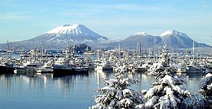
Mount Edgecumbe (Alaska)
Encyclopedia
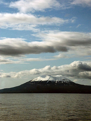
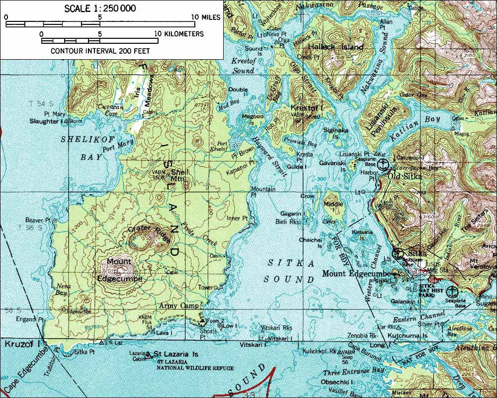
Kruzof Island
Kruzof Island is an island in the Alexander Archipelago in southeastern Alaska at . It is about west of Sitka, and is part of the City and Borough of Sitka. It was named in 1805 by Captain U.T. Lisianski as Crooze Island, after a Russian Admiral...
, Alaska
Alaska
Alaska is the largest state in the United States by area. It is situated in the northwest extremity of the North American continent, with Canada to the east, the Arctic Ocean to the north, and the Pacific Ocean to the west and south, with Russia further west across the Bering Strait...
, of which it is the highest point. In the Tlingit
Tlingit language
The Tlingit language ) is spoken by the Tlingit people of Southeast Alaska and Western Canada. It is a branch of the Na-Dené language family. Tlingit is very endangered, with fewer than 140 native speakers still living, all of whom are bilingual or near-bilingual in English...
language it is called L’ux. Mt. Edgecumbe is a local landmark and a tourist attraction
Tourist attraction
A tourist attraction is a place of interest where tourists visit, typically for its inherent or exhibited cultural value, historical significance, natural or built beauty, or amusement opportunities....
.
Naming
Mount Edgecumbe was named by BritishUnited Kingdom
The United Kingdom of Great Britain and Northern IrelandIn the United Kingdom and Dependencies, other languages have been officially recognised as legitimate autochthonous languages under the European Charter for Regional or Minority Languages...
Captain James Cook
James Cook
Captain James Cook, FRS, RN was a British explorer, navigator and cartographer who ultimately rose to the rank of captain in the Royal Navy...
in 1778 after a hill overlooking Plymouth Harbor, England, or possibly for George, Earl of Edgcumbe
George Edgcumbe, 1st Earl of Mount Edgcumbe
Admiral George Edgcumbe, 1st Earl of Mount Edgcumbe, PC was a British peer, naval officer and politician....
. It had previously been named Montaña de San Jacinto (to La Pérouse
Jean-François de Galaup, comte de La Pérouse
Jean François de Galaup, comte de Lapérouse was a French Navy officer and explorer whose expedition vanished in Oceania.-Early career:...
"Mount Saint Hyacinth
Saint Hyacinth
Saint Hyacinth, O.P., was educated in Paris and Bologna. A Doctor of Sacred Studies and a secular priest, he worked to reform women's monasteries in his native Poland...
") in 1775 by Spanish
Spain
Spain , officially the Kingdom of Spain languages]] under the European Charter for Regional or Minority Languages. In each of these, Spain's official name is as follows:;;;;;;), is a country and member state of the European Union located in southwestern Europe on the Iberian Peninsula...
explorer Juan de la Bodega to honor the saint whose day it was.
Ascent
Mount Edgecumbe can be easily ascended in a day hike. Although finding marine transportation from the nearby town of Sitka to Kruzof Island is often the biggest obstacle, once hikers reach the island and the Mt. Edgecumbe's trailhead of Fred's Creek, the trip to the base of volcano is relatively flat while passing through open expanses of muskegMuskeg
Muskeg is an acidic soil type common in Arctic and boreal areas, although it is found in other northern climates as well. Muskeg is approximately synonymous with bogland but muskeg is the standard term in Western Canada and Alaska, while 'bog' is common elsewhere. The term is of Cree origin, maskek...
. There is a three-sided shelter at about mile 3.5, halfway to the mountain and a small campsite right before the final ascent . At about mile six, the climb begins. Soon tree line is achieved and a series of posts guide hikers through the scree
Scree
Scree, also called talus, is a term given to an accumulation of broken rock fragments at the base of crags, mountain cliffs, or valley shoulders. Landforms associated with these materials are sometimes called scree slopes or talus piles...
if there is bad weather. The top is barren and often windy.
The trail and original cabin were constructed by the Civilian Conservation Corps
Civilian Conservation Corps
The Civilian Conservation Corps was a public work relief program that operated from 1933 to 1942 in the United States for unemployed, unmarried men from relief families, ages 18–25. A part of the New Deal of President Franklin D...
.
Eruptions
- 7220 BC8th millennium BCIn the 8th millennium BC, agriculture became widely practised in the Fertile Crescent and Anatolia.Pottery became widespread and animal husbandry spread to Africa and Eurasia. World population was approximately 5 million.-Events:*c. 8000 BC—The last glacial period ends.*c...
- 3810 BC39th century BC-Events:* The Post Track, an ancient causeway in the Somerset Levels, England, is built, ca. 3838 BC. It is one of the oldest engineered roads discovered in Northern Europe....
- 2220 BC23rd century BCThe 23rd century BC is a century which lasted from the year 2300 BC to 2201 BC.-Events:*2334 BC – 2279 BC: Sargon of Akkad's conquest of Mesopotamia....
±100 years
False eruption
On April 1, 1974, a local prankster named Porky Bickar flew in and ignited 100 old tires in the crater, convincing nearby residents of Sitka, Alaska that the volcano was erupting.External links
- Topographic map of Mount Edgecumbe (1:250,000 scale) from USGS Sitka and Port AlexanderPort Alexander, AlaskaPort Alexander is a city at the southeastern corner of Baranof Island in Petersburg Census Area, Alaska, United States. At the 2000 census the population was 81.-Geography:Port Alexander is located at ....
- Alaska Volcano Observatory