

Siskiyou Trail
Encyclopedia
Willamette Valley
The Willamette Valley is the most populated region in the state of Oregon of the United States. Located in the state's northwest, the region is surrounded by tall mountain ranges to the east, west and south and the valley's floor is broad, flat and fertile because of Ice Age conditions...
; modern-day Interstate 5
Interstate 5
Interstate 5 is the main Interstate Highway on the West Coast of the United States, running largely parallel to the Pacific Ocean coastline from Canada to Mexico . It serves some of the largest cities on the U.S...
follows this pioneer path. Originally based on existing Native American
Native Americans in the United States
Native Americans in the United States are the indigenous peoples in North America within the boundaries of the present-day continental United States, parts of Alaska, and the island state of Hawaii. They are composed of numerous, distinct tribes, states, and ethnic groups, many of which survive as...
foot trails winding their way through river valleys, the Siskiyou Trail provided the shortest practical travel path between early settlements in California and Oregon.
Development
The earliest European or American visitors along the Siskiyou Trail were likely hunters and trappers connected with the Hudson's Bay CompanyHudson's Bay Company
The Hudson's Bay Company , abbreviated HBC, or "The Bay" is the oldest commercial corporation in North America and one of the oldest in the world. A fur trading business for much of its existence, today Hudson's Bay Company owns and operates retail stores throughout Canada...
(HBC) who, in the 1820s, began to travel the rivers of Southern Oregon and Northern California in search of fur and pelts.
The HBC had established itself on the Columbia River
Columbia River
The Columbia River is the largest river in the Pacific Northwest region of North America. The river rises in the Rocky Mountains of British Columbia, Canada, flows northwest and then south into the U.S. state of Washington, then turns west to form most of the border between Washington and the state...
, and built Fort Vancouver
Fort Vancouver
Fort Vancouver was a 19th century fur trading outpost along the Columbia River that served as the headquarters of the Hudson's Bay Company in the company's Columbia District...
, its regional headquarters in 1824. HBC parties began to explore south toward California in 1825. Alexander McLeod
Alexander Roderick McLeod
Alexander Roderick McLeod was a fur trader and explorer who began his career with the North West Company in 1802.McLeod became a chief trader with the Hudson's Bay Company after they joined with the NWC in 1821...
led exploration and trapping parties south beginning in 1826, reaching the Klamath River
Klamath River
The Klamath River is an American river that flows southwest through Oregon and northern California, cutting through the Cascade Range to empty into the Pacific Ocean. The river drains an extensive watershed of almost that stretches from the high desert country of the Great Basin to the temperate...
in 1827, and the Sacramento River
Sacramento River
The Sacramento River is an important watercourse of Northern and Central California in the United States. The largest river in California, it rises on the eastern slopes of the Klamath Mountains, and after a journey south of over , empties into Suisun Bay, an arm of the San Francisco Bay, and...
in 1828. In 1829 he led the first HBC trapping expedition to the Sacramento Valley
Sacramento Valley
The Sacramento Valley is the portion of the California Central Valley that lies to the north of the San Joaquin-Sacramento Delta in the U.S. state of California. It encompasses all or parts of ten counties.-Geography:...
, which reached as far south as today's Stockton
Stockton, California
Stockton, California, the seat of San Joaquin County, is the fourth-largest city in the Central Valley of the U.S. state of California. With a population of 291,707 at the 2010 census, Stockton ranks as this state's 13th largest city...
.
McLeod's exploring and trapping expeditions essentially established the Siskiyou Trail, linking Fort Vancouver with the Sacramento Valley. At first it was known by names such as the California Brigade Trail and the Southern Party Trail.
McLeod and other members of his parties reported that the Native Americans south of the Umpqua River
Umpqua River
The Umpqua River on the Pacific coast of Oregon in the United States is approximately long. One of the principal rivers of the Oregon Coast and known for bass and shad, the river drains an expansive network of valleys in the mountains west of the Cascade Range and south of the Willamette Valley,...
, along the Klamath and Siuslaw River
Siuslaw River
The Siuslaw River is a river, approximately 110 mi long, along the Pacific coast of Oregon in the United States. It drains an area of approximately in the Central Oregon Coast Range southwest of the Willamette Valley and north of the watershed of the Umpqua River.It rises in the mountains...
s, had never seen white men before. Although the 42nd parallel
42nd parallel north
The 42nd parallel north is a circle of latitude that is 42 degrees north of the Earth's equatorial plane. It crosses Europe, the Mediterranean Sea, Asia, the Pacific Ocean, North America, and the Atlantic Ocean....
(today the boundary between California and Oregon) marked the northern border of Mexican California
Alta California
Alta California was a province and territory in the Viceroyalty of New Spain and later a territory and department in independent Mexico. The territory was created in 1769 out of the northern part of the former province of Las Californias, and consisted of the modern American states of California,...
, the Mexicans knew little about the interior and the HBC trappers ranged south at will.
Other HBC trappers who made early use of the Siskiyou Trail include Peter Skene Ogden
Peter Skene Ogden
Peter Skene Ogden , was a fur trader and a Canadian explorer of what is now British Columbia and the American West...
and Michel Laframboise.
In 1834, Ewing Young
Ewing Young
Ewing Young was an American fur trapper and trader from Tennessee who traveled Mexican southwestern North America and California before settling in the Oregon Country. As a prominent and wealthy citizen there, his death was the impetus for the early formation of government in what became the state...
brought a herd of horses and mules over the Siskiyou Trail from missions in California for sale at British and American settlements in Oregon. Although this initial effort was met with suspicion by Hudson's Bay Company officials in Oregon, Young returned to California in 1837, where he purchased 700 head of cattle which he drove over the Siskiyou Trail to Oregon. This monumental task, requiring nearly three months, helped widen and establish the trail thereby solidifying the new American settlements in Oregon.
In 1841 an overland party of the United States Exploring Expedition
United States Exploring Expedition
The United States Exploring Expedition was an exploring and surveying expedition of the Pacific Ocean and surrounding lands conducted by the United States from 1838 to 1842. The original appointed commanding officer was Commodore Thomas ap Catesby Jones. The voyage was authorized by Congress in...
came down the Siskiyou Trail with the first scientists and cartographers in the region.
The California Gold Rush
California Gold Rush
The California Gold Rush began on January 24, 1848, when gold was found by James W. Marshall at Sutter's Mill in Coloma, California. The first to hear confirmed information of the gold rush were the people in Oregon, the Sandwich Islands , and Latin America, who were the first to start flocking to...
, beginning in 1848, ushered in dramatically increased use of the Siskiyou Trail. The discovery of gold in Siskiyou County and especially at Yreka, California, brought thousands of Forty-Niners along the trail in search of riches. The terrain was so rugged over the mountains of the trail, that travel was restricted to mule trains and horses. Early travelers were able to travel perhaps 20 miles (32.2 km) in a day, stopping at wayside inns and hostels, such as at Portuguese Flat
Portuguese Flat, California
Portuguese Flat was a California mining camp of the early 1850s during the California Gold Rush, consisting largely of Portuguese miners. It was located about 35 miles north of Redding, California near what is currently now the unincorporated community of Pollard Flat...
, Upper Soda Springs
Upper Soda Springs
Upper Soda Springs is on the banks of the Sacramento River in Dunsmuir, California, USA. It consists of approximately ten acres of level ground on both sides of the River, the surrounding hillsides, and continues north along the eastern bank of the Sacramento River to the Dunsmuir City Park...
and Sisson, in Northern California. It was not until the 1860s that toll roads usable by stagecoaches were finally carved through the mountains of Northern California, permitting uninterrupted stagecoach travel for the length of the Siskiyou Trail.
The first telegraph line connected early towns along the trail in 1864. Development accelerated with the arrival of the Central Pacific Railroad
Central Pacific Railroad
The Central Pacific Railroad is the former name of the railroad network built between California and Utah, USA that formed part of the "First Transcontinental Railroad" in North America. It is now part of the Union Pacific Railroad. Many 19th century national proposals to build a transcontinental...
track completed in 1887, which followed the path of the Siskiyou Trail.
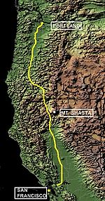
Route
The historic route of the Siskiyou Trail extended from the Columbia DistrictColumbia District
The Columbia District was a fur trading district in the Pacific Northwest region of British North America in the 19th century. It was explored by the North West Company between 1793 and 1811, and established as an operating fur district around 1810...
headquarters of the Hudson's Bay Company
Hudson's Bay Company
The Hudson's Bay Company , abbreviated HBC, or "The Bay" is the oldest commercial corporation in North America and one of the oldest in the world. A fur trading business for much of its existence, today Hudson's Bay Company owns and operates retail stores throughout Canada...
, at Fort Vancouver in southern Washington, to the San Francisco Bay Area
San Francisco Bay Area
The San Francisco Bay Area, commonly known as the Bay Area, is a populated region that surrounds the San Francisco and San Pablo estuaries in Northern California. The region encompasses metropolitan areas of San Francisco, Oakland, and San Jose, along with smaller urban and rural areas...
. In California the trail went through or near modern-day Redding
Redding, California
Redding is a city in far-Northern California. It is the county seat of Shasta County, California, USA. With a population of 89,861, according to the 2010 Census...
, Dunsmuir
Dunsmuir, California
Dunsmuir is a city in Siskiyou County, California, United States. The population was 1,650 at the 2010 census, down from 1,923 at the 2000 census. It is currently a hub of tourism in Northern California as visitors enjoy fishing, skiing, climbing, or sight-seeing...
and Yreka, California
Yreka, California
Yreka is the county seat of Siskiyou County, California, United States. The population was 7,765 at the 2010 census, up from 7,290 at the 2000 census.- History:...
. In Oregon the route went through or near modern-day Ashland
Ashland, Oregon
Ashland is a city in Jackson County, Oregon, United States, near Interstate 5 and the California border, and located in the south end of the Rogue Valley. It was named after Ashland County, Ohio, point of origin of Abel Helman and other founders, and secondarily for Ashland, Kentucky, where other...
, Grants Pass
Grants Pass, Oregon
-Rogue River:The Rogue River runs through Grants Pass.-Demographics:As of the census of 2000, there were 23,003 people, 9,376 households, and 5,925 families residing in the city. The population density was . There were 9,885 housing units at an average density of 1,303.3 per square mile . By 2008,...
, Eugene
Eugene, Oregon
Eugene is the second largest city in the U.S. state of Oregon and the seat of Lane County. It is located at the south end of the Willamette Valley, at the confluence of the McKenzie and Willamette rivers, about east of the Oregon Coast.As of the 2010 U.S...
, Salem
Salem, Oregon
Salem is the capital of the U.S. state of Oregon, and the county seat of Marion County. It is located in the center of the Willamette Valley alongside the Willamette River, which runs north through the city. The river forms the boundary between Marion and Polk counties, and the city neighborhood...
and Portland
Portland, Oregon
Portland is a city located in the Pacific Northwest, near the confluence of the Willamette and Columbia rivers in the U.S. state of Oregon. As of the 2010 Census, it had a population of 583,776, making it the 29th most populous city in the United States...
.
The trail used the valleys of the Willamette
Willamette River
The Willamette River is a major tributary of the Columbia River, accounting for 12 to 15 percent of the Columbia's flow. The Willamette's main stem is long, lying entirely in northwestern Oregon in the United States...
, Umpqua
Umpqua River
The Umpqua River on the Pacific coast of Oregon in the United States is approximately long. One of the principal rivers of the Oregon Coast and known for bass and shad, the river drains an expansive network of valleys in the mountains west of the Cascade Range and south of the Willamette Valley,...
, Rogue
Rogue River (Oregon)
The Rogue River in southwestern Oregon in the United States flows about in a generally westward direction from the Cascade Range to the Pacific Ocean. Known for its salmon runs, whitewater rafting, and rugged scenery, it was one of the original eight rivers named in the Wild and Scenic Rivers Act...
, Klamath
Klamath River
The Klamath River is an American river that flows southwest through Oregon and northern California, cutting through the Cascade Range to empty into the Pacific Ocean. The river drains an extensive watershed of almost that stretches from the high desert country of the Great Basin to the temperate...
, Shasta
Shasta River
The Shasta River is a tributary of the Klamath River, approximately long, in northern California in the United States. It drains the Shasta Valley on the west and north sides of Mount Shasta in the Cascade Range....
and Sacramento
Sacramento River
The Sacramento River is an important watercourse of Northern and Central California in the United States. The largest river in California, it rises on the eastern slopes of the Klamath Mountains, and after a journey south of over , empties into Suisun Bay, an arm of the San Francisco Bay, and...
rivers to make the connection between Oregon and California, and to traverse the rugged mountains of Northern California and Southern Oregon (Siskiyou Mountains
Siskiyou Mountains
The Siskiyou Mountains are a coastal mountain range in the northern Klamath Mountains in northwestern California and southwestern Oregon in the United States. They extend in an arc for approximately from east of Crescent City, California northeast along the north side of the Klamath River into...
). The trail crested at the Siskiyou Summit
Siskiyou Summit
Siskiyou Summit is a mountain pass that carries Interstate 5 through the Siskiyou Mountains near the border between the U.S. states of California and Oregon. The summit is located on the Oregon side, approximately north of the state line, and, at , is the highest point on Interstate 5...
(elevation 4310 ft (1,313.7 m)) just north of the Oregon-California border, and went past or near landmarks such as Mount Shasta
Mount Shasta, California
Mount Shasta is a city in Siskiyou County, California, located at around 3,600 ft on the flanks of Mount Shasta, a prominent northern California landmark. The city is less than southwest of the summit of its namesake volcano...
, Upper Soda Springs
Upper Soda Springs
Upper Soda Springs is on the banks of the Sacramento River in Dunsmuir, California, USA. It consists of approximately ten acres of level ground on both sides of the River, the surrounding hillsides, and continues north along the eastern bank of the Sacramento River to the Dunsmuir City Park...
, Castle Crags
Castle Crags
Castle Crags is a dramatic and well-known rock formation in Northern California. Although the mountains of Northern California consist largely of rocks of volcanic and sedimentary origin, granite bodies intruded many parts of the area during the Jurassic period...
and Sutter Buttes
Sutter Buttes
The Sutter Buttes are a small circular complex of eroded volcanic lava domes which rise as buttes above the flat plains of the Central Valley of California in the United States. The highest peak, South Butte, reaches about above sea level. The Buttes are located just outside of Yuba City,...
.
Modern roads
Between 1869 and 1887 the Oregon & California Railroad Company built a railroad along this route, crossing Siskiyou SummitSiskiyou Summit
Siskiyou Summit is a mountain pass that carries Interstate 5 through the Siskiyou Mountains near the border between the U.S. states of California and Oregon. The summit is located on the Oregon side, approximately north of the state line, and, at , is the highest point on Interstate 5...
in 1887. In the mid-1910s the pioneering Pacific Highway
Pacific Highway (US)
Pacific Highway is the name of several north-south highways in the Pacific Coast region of the Western United States, either by legislation officially designating it as such or by common usage....
, later numbered as U.S. Highway 99, provided the first easy automobile access along the path of the trail. Interstate 5
Interstate 5
Interstate 5 is the main Interstate Highway on the West Coast of the United States, running largely parallel to the Pacific Ocean coastline from Canada to Mexico . It serves some of the largest cities on the U.S...
was built in the 1960s along the route of the original 1820s Siskiyou Trail. About 4 miles (7 km) north of the California border, and just south of Ashland, Oregon
Ashland, Oregon
Ashland is a city in Jackson County, Oregon, United States, near Interstate 5 and the California border, and located in the south end of the Rogue Valley. It was named after Ashland County, Ohio, point of origin of Abel Helman and other founders, and secondarily for Ashland, Kentucky, where other...
, the highway crosses Siskiyou Summit
Siskiyou Summit
Siskiyou Summit is a mountain pass that carries Interstate 5 through the Siskiyou Mountains near the border between the U.S. states of California and Oregon. The summit is located on the Oregon side, approximately north of the state line, and, at , is the highest point on Interstate 5...
, the highest point on I-5 (elevation 4310 ft (1,313.7 m)). The railroad and interstate highway deviate from the original trail in small ways according to the needs and engineering available to their builders.