
Oregon Trail
Encyclopedia
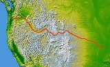
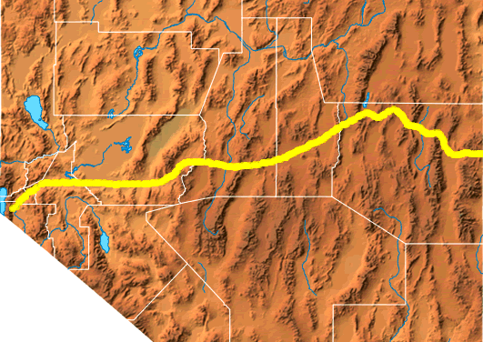
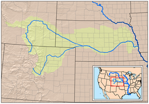
The Oregon Trail is a 2000 miles (3,218.7 km) historic east-west wagon route that connected the Missouri River
to valleys in Oregon
and locations in between.
After 1840 steam-powered riverboat
s and steamboat
s traversing up and down the Ohio
, Mississippi
and Missouri
rivers sped settlement and development in the flat region from the Appalachian mountains to the American Rocky Mountains. The boats serviced the jumping off points for wagon trains that crossed the mountains headed to rich farmlands in Oregon and California. With disputes with Mexico and Britain settled by 1848, the new lands proved highly attractive. Getting there by sea meant a very long trip around South America, a journey which was expensive and dangerous and took longer than walking. It flourished from the 1840s until the coming of the railroad at the end of the 1860s. The trip on foot took four to six months. It was the oldest of the northern commercial and emigrant trail
s and was originally discovered and used by fur trappers and traders in the fur trade
from about 1811 to 1840. In its earliest days much of the future Oregon Trail was not passable to wagons but was passable everywhere only to men walking or riding horses and leading mule train
s. By 1836, when the first Oregon wagon trains were organized at Independence, Missouri
, the trail had been improved so much that it was possible to take wagons to Fort Hall
, Idaho
. By 1843 a rough wagon trail had been cleared to The Dalles, Oregon
, and by 1846 all the way around Mount Hood
to the Willamette Valley
in the state of Oregon. What became called the Oregon Trail was complete even as improved roads, "cutouts", ferries and bridges made the trip faster and safer almost every year.
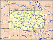
The eastern part of the Oregon Trail spanned part of the future state of Kansas
and nearly all of what are now the states of Nebraska
and Wyoming
. The western half of the trail spanned most of the future states of Idaho and Oregon. From various "jumping off points" in Missouri, Iowa or Nebraska
, the routes converged along the lower Platte River Valley
, near Fort Kearny
, Nebraska Territory. Small steamboats carrying fur traders navigated the Missouri River up to the Yellowstone River
in Montana as early as 1832. Larger steamboats traveling much above St. Joseph were blocked until dredging opened a bigger channel in 1852.
Oregon Trail travelers could purchase repairs, new supplies, fresh teams and help from fort-trading posts such as Fort Kearny and Fort Laramie. Jim Bridger
's Fort Bridger
and Hudson's Bay Company-owned Fort Hall
and Fort Boise
in Idaho; Fort Nez Perces
(Fort Walla Walla) in Oregon and Fort Vancouver
in Washington. Other supplies, fresh teams and repairs could often be obtained from temporary trading posts and ferries set up by entrepreneurs along the trail during the traveling season. From the early to mid 1830s, but especially after the organization of the first large wagon train
s in Independence
, Missouri in 1841 and through the epoch years 1846–1869 the Oregon Trail and its many off shoots was used by about 400,000 settlers, ranchers, farmers, miners, and businessmen and their families. The eastern half of the trail was also used by travelers on the California Trail
(from 1843), Bozeman Trail
(from 1863), and Mormon Trail
(from 1847) which used many of the same eastern trails before turning off to their separate destinations.
Once the first transcontinental railroad
by the Union Pacific and the Central Pacific
was completed in 1869, the use of this trail by long distance travelers fell off because the train took seven days and at $69 was much cheaper. Travelers going to Oregon could take the train to California and catch a coastal steamer to Oregon. By 1883 the Northern Pacific Railroad had reached Portland
, Oregon, and thereafter there were fewer and fewer wagon trains each year along the western trail. The legacy persisted as highways such as Interstate 80
followed the same course westward and passed through towns originally established to service the Oregon Trail.
To complete the journey in one traveling season most travelers left in April to May—as soon as there was enough grass for forage for the animals and the trails dried out. To meet the constant need for water, grass, and fuel for campfires the trail followed various rivers and streams across the continent. The network of trails required little initial preparation to be made passable for wagons. People using the trail traveled in wagons, pack trains, on horseback, on foot, and sometimes by raft or boat to establish new farms, lives, and businesses in the Oregon Country.
issued the following instructions to Meriwether Lewis
: "The object of your mission is to explore the Missouri river, & such principal stream of it, as, by its course & communication with the waters of the Pacific Ocean, whether the Columbia, Oregon, Colorado and/or other river may offer the most direct & practicable water communication across this continent, for the purposes of commerce." Although Lewis and William Clark found a path to the Pacific Ocean, it was not until 1859 that a direct and practicable route, the Mullan Road
, connected the Missouri River to the Columbia River
.
 The first land route across what is now the United States was partially mapped by the Lewis and Clark Expedition between 1804 and 1806. Lewis and Clark initially believed they had found a practical overland route to the west coast; however, the two passes they found going through the Rocky Mountains
, Lemhi Pass
and Lolo Pass
, turned out to be much too difficult for wagons to pass through without considerable road work. On the return trip in 1806 they traveled from the Columbia River to the Snake River
and the Clearwater River
over Lolo pass again. They then traveled overland up the Blackfoot River
and crossed the Continental Divide at Lewis and Clark Pass and on to the head of the Missouri River. This was ultimately a shorter and faster route than the one they followed west. This route had the disadvantages of being much too rough for wagons and controlled by the Blackfoot
Indians. Even though Lewis and Clark had only traveled a narrow portion of the upper Missouri River drainage and part of the Columbia River drainage, these were considered the two major rivers draining most of the Rocky Mountains
, and the expedition confirmed that there was no "easy" route through the northern Rocky Mountains as Jefferson had hoped. Nonetheless, this famous expedition had mapped both the eastern and western river valleys (Platte and Snake Rivers) that bookend the route of the Oregon Trail (and other emigrant trail
s) across the continental dividethey just had not located the South Pass
or some of the interconnecting valleys later used in the high country. They did show the way for the mountain men, who within a decade would find a better way across, even if it was not to be an easy way.
of the American Fur Company
, outfitted an expedition (known as the Astor Expedition or Astorians) under Wilson Price Hunt to find a possible overland supply route and trapping territory for fur trading
posts. Fearing attack by the Blackfoot Indians, the overland expedition veered south of Lewis and Clark's route into what is now Wyoming and in the process passed across Union Pass
and into Jackson Hole
, Wyoming. From there they went over the Teton Range
via Teton Pass
and then down to the Snake River
in Idaho
. They abandoned their horses at the Snake River, made dugout canoes, and attempted to use the river for transport. After a few days' travel they soon discovered that steep canyons, waterfalls and impassable rapids made travel by river impossible. Too far from their horses to retrieve them, they had to cache most of their goods and walk the rest of the way to the Columbia River where they made new boats and traveled to the newly established Fort Astoria
. The expedition demonstrated that much of the route along the Snake River plain and across to the Columbia was passable by pack train or with minimal improvements, even wagons. This knowledge would be incorporated into the concatenated trail segments as the Oregon Trail took its early shape.
In early 1811, the supply ship Tonquin
left supplies and men to establish Fort Astoria
(Oregon
) at the mouth of the Columbia River
and Fort Okanogan
(Washington) at the confluence of the Okanogan
and Columbia River
s. The Tonquin then went up the coast to Puget Sound
for a trading expedition. There it was attacked and overwhelmed by Indians before being blown up, killing all the crew and many Indians.
American Fur Company partner Robert Stuart
led a small group of men back east to report to Astor. The group planned to retrace the path followed by the overland expedition back up to the east following the Columbia and Snake rivers.
Fear of Indian attack near Union Pass in Wyoming forced the group further south where they luckily discovered South Pass
, a wide and easy pass over the Continental Divide. The party continued east via the Sweetwater River
, North Platte River
(where they spent the winter of 1812–1813) and Platte River
to the Missouri River, finally arriving in St. Louis in the spring of 1813. The route they had used appeared to potentially be a practical wagon route, requiring minimal improvements, and Stuart's journals provided a meticulous account of most of the route. Because of the War of 1812
and the lack of U.S. fur trading posts in the Oregon Country, most of the route was unused for more than 10 years.
and his team of British North West Company explorers came floating down the Columbia to Fort Astoria. He had just completed an epic journey through much of western Canada and most of the Columbia River drainage system. He was mapping the country for possible fur trading posts. Along the way he camped at the confluence of the Columbia and Snake rivers and posted a notice claiming the land for Britain and stating the intention of the North West Company to build a fort on the site (Fort Nez Perces
was later established there). Astor, pressured by potential confiscation by the British navy of their forts and supplies in the War of 1812
, sold to the North West Company in 1812 their forts, supplies and furs on the Columbia and Snake River. The North West Company started establishing more forts and trading posts of their own.
By 1821, when armed hostilities broke out with their Hudson's Bay Company rivals, the North West Company was pressured by the British government to merge with the Hudson's Bay Company. The Hudson's Bay Company had nearly a complete monopoly on trading (and most governing issues) in the Columbia District, or Oregon Country as it was referred to by the Americans, and also in Rupert's Land
(western Canada). That year the British parliament passed a statute applying the laws of Upper Canada
to the district and giving the Hudson's Bay Company power to enforce those laws.
From 1812 to 1840 the British through the Hudson's Bay Company
had nearly complete control of the Pacific Northwest and the western half of the Oregon Trail. In theory, the Treaty of Ghent
ending the War of 1812 restored the U.S. back to its possessions in Oregon territory. "Joint occupation" of the region was formally established by the Anglo-American Convention of 1818. The British through the Hudson's Bay Company
tried to discourage any U.S. trappers, traders and settlers from doing any significant trapping, trading or settling in the Pacific Northwest. American fur trappers, traders, missionaries, and later settlers all worked to break this monopoly. They were eventually successful.
The York Factory Express
, establishing another route to the Oregon territory, evolved from an earlier express brigade used by the North West Company between Fort Astoria and Fort William
, Ontario on Lake Superior
. By 1825 the Hudson's Bay Company started using two brigades, each setting out from opposite ends of the express route—one from Fort Vancouver
on the Columbia River and the other from York Factory on Hudson Bay—in spring and passing each other in the middle of the continent. This established a 'quick' (about 100 days for 2600 miles (4,184.3 km)) one way to resupply their forts and fur trading centers as well as collecting the furs the posts had bought and transmitting messages between Fort Vancouver and York Factory on Hudson Bay.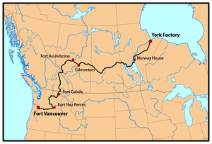 The Hudson's Bay Company built a new much larger Fort Vancouver
in 1824 slightly upstream of Fort Astoria
on the Washington side of the Columbia River
(they were hoping the Columbia would be the future Canada–U.S. border). The fort quickly became the center of activity in the Pacific Northwest. Every year ships would come from London to the Pacific (via Cape Horn
) to drop off supplies and trade goods in their trading posts in the Pacific Northwest and pick up the accumulated furs used to pay for these supplies. It was the nexus for the fur trade on the Pacific Coast; its influence reached from the Rocky Mountains
to the Hawaiian Islands
, and from Russian Alaska
into Mexican-controlled California. At its pinnacle in about 1840, Fort Vancouver and its Factor (manager) watched over 34 outposts, 24 ports, 6 ships, and about 600 employees.
When emigration over the Oregon Trail began in earnest in about 1836, for many settlers the fort became the last stop on the Oregon Trail where they could get supplies, aid and help before starting their homestead. Fort Vancouver was the main re-supply point for nearly all Oregon trail travelers until U.S. towns could be established. Fort Colville
was established in 1825 on the Columbia river near Kettle Falls
as a good site to collect furs and control the upper Columbia River fur trade. Fort Nisqually
was built near the present town of DuPont
, Washington and was the first Hudson's Bay Company fort on Puget Sound. Fort Victoria
was erected in 1843 and became the headquarters of operations in British Columbia, eventually growing into modern-day Victoria
, the capital city of British Columbia.
By 1840 the Hudson's Bay Company had three forts: Fort Hall
(purchased from Nathaniel Jarvis Wyeth
in 1837), Fort Boise
and Fort Nez Perce on the western end of the Oregon Trail route as well as Fort Vancouver
near its terminus in the Willamette Valley
. With minor exceptions they all gave substantial and often desperately needed aid to the early Oregon Trail pioneers.
When the fur trade slowed in 1840 because of fashion changes in men's hats, the value of the Pacific Northwest to the British was seriously diminished. Canada had very few potential settlers who were willing to move over 2,500 miles to the Pacific Northwest, although several hundred ex-trappers, British and American, and their families did start settling in Oregon, Washington and California. They used most of the York Express route through northern Canada. In 1841 James Sinclair
, on orders from Sir George Simpson
, guided nearly 200 settlers from the Red River Settlement (located at the junction of the Assiniboine River
and Red River
near present Winnipeg, Canada) into the Oregon territory. This attempt at settlement failed when most of the families joined the settlers in the Willamette Valley, with their promise of free land and HBC-free government.
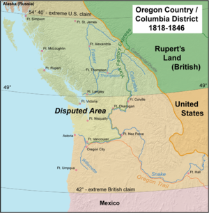 In 1846 the Oregon Treaty
ending the Oregon boundary dispute
was signed with Britain. The British lost the land north of the Columbia River they had so long controlled. The new Canada–United States border was established much further north at the 49th parallel
. The treaty granted the Hudson's Bay Company navigation rights on the Columbia River for supplying their fur posts, clear titles to their trading post properties allowing them to be sold later if they wanted, and left the British with good anchorages at Vancouver and Victoria
, British Columbia. It gave the United States what it mostly wanted, a 'reasonable' boundary and a good anchorage on the West Coast in Puget Sound. While there were almost no United States settlers in the future state of Washington in 1846, the United States had already demonstrated it could induce thousands of settlers to go to the Oregon Territory, and it would be only a short time before they would vastly outnumber the few hundred Hudson's Bay Company employees and retirees living in Washington.
By overland travel, American missionaries and early settlers (initially mostly ex-trappers) started showing up in Oregon around 1824. Although officially the Hudson's Bay Company discouraged settlement because it interfered with their lucrative fur trade, their Chief Factor at Fort Vancouver, Dr. John McLoughlin
, gave substantial help including employment until they could get established. By 1843, when 700–1,000 settlers arrived, the American settlers greatly outnumbered the nominally British settlers in Oregon. McLoughlin, despite working for the British-based Hudson's Bay Company, gave help in the form of loans, medical care, shelter, clothing, food, supplies and seed to United States emigrants. These new emigrants often arrived in Oregon tired, worn out, nearly penniless, with insufficient food or supplies just as winter was coming on. McLoughlin would later be hailed as the Father of Oregon.
 Reports from expeditions in 1806 by Lieutenant Zebulon Pike
and in 1819 by Major Stephen Long described the Great Plains
as "unfit for human habitation" and as "The Great American Desert
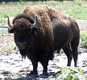
". These descriptions were mainly based on the relative lack of timber and surface water. The images of sandy wastelands conjured up by terms like "desert" were tempered by the many reports of vast herds of millions of Plains Bison
that somehow managed to live in this "desert". In the 1840s, the Great Plains appeared to be unattractive for settlement and were illegal for homesteading until well after 1846—initially it was set aside by the U.S. government for Indian settlements. The next available land for general settlement, Oregon, appeared to be free for the taking and had fertile lands, disease free climate (yellow fever
and malaria
were prevalent in much of the Missouri and Mississippi River
drainage then), extensive uncut, unclaimed forests, big rivers, potential seaports, and only a few nominally British settlers.
, Robert Stuart
, William Henry Ashley
, Jedediah Smith
, William Sublette
, Andrew Henry
, Thomas Fitzpatrick
, Kit Carson
, Jim Bridger
, Peter Skene Ogden
, David Thompson
, James Douglas
, Donald Mackenzie, Alexander Ross
, James Sinclair
and other mountain men
. Besides discovering and naming many of the rivers and mountains in the Intermountain West
and Pacific Northwest they often kept diaries of their travels and were available as guides and consultants when the trail started to become open for general travel. The fur trade business wound down to a very low level just as the Oregon trail traffic seriously began around 1840.
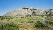
In fall of 1823, Jedediah Smith
and Thomas Fitzpatrick
led their trapping crew south from the Yellowstone River
to the Sweetwater River. They were looking for a safe location to spend the winter. Smith reasoned since the Sweetwater flowed east it must eventually run into the Missouri River. Trying to transport their extensive fur collection down the Sweetwater and North Platte River, they found after a near disastrous canoe crash that the rivers were too swift and rough for water passage. On July 4, 1824, they cached their furs under a dome of rock they named Independence Rock
and started their long trek on foot to the Missouri River. Upon arriving back in a settled area they bought pack horses (on credit) and retrieved their furs. They had re-discovered the route that Robert Stuart had taken in 1813—eleven years before. Thomas Fitzpatrick was often hired as a guide when the fur trade dwindled in 1840. Jedediah Smith was killed by Indians about 1831.
 Up to 3,000 Mountain men
were trappers and explorers
, employed by various British and United States fur companies or working as free trappers, who roamed the North American Rocky Mountains from about 1810 to the early 1840s. They usually traveled in small groups for mutual support and protection. Trapping took place in the fall when the fur became prime. Mountain men primarily trapped beaver
and sold the skins. A good beaver skin could bring up to $4.00 at a time when a man's wage was often $1.00/day. Some were more interested in exploring the West. In 1825, the first significant American Rendezvous occurred on the Henry's Fork of the Green River
. The trading supplies were brought in by a large party using pack trains originating on the Missouri River. These pack trains were then used to haul out the fur bales. They normally used the north side of the Platte River—the same route used 20 years later by the Mormon Trail
. For the next 15 years the American rendezvous was an annual event moving to different locations, usually somewhere on the Green River in the future state of Wyoming
. Each rendezvous, occurring during the slack summer period, allowed the fur traders to trade for and collect the furs from the trappers and their Indian allies without having the expense of building or maintaining a fort or wintering over in the cold Rockies. In only a few weeks at a rendezvous a year's worth of trading and celebrating would take place as the traders took their furs and remaining supplies back east for the winter and the trappers faced another fall and winter with new supplies. Jim Beckwourth describes: "Mirth, songs, dancing, shouting, trading, running, jumping, singing, racing, target-shooting, yarns, frolic, with all sorts of extravagances that white men or Indians could invent." In 1830, William Sublette
brought the first wagons carrying his trading goods up the Platte, North Platte
, and Sweetwater River (Wyoming)
before crossing over South Pass
to a fur trade rendezvous on the Green River near the future town of Big Piney
, Wyoming. He had a crew that dug out the gullies and river crossings and cleared the brush where needed. This established that the eastern part of most of the Oregon Trail was passable by wagons. In the late 1830s the Hudson's Bay Company instituted a policy intended to destroy or weaken the American fur trade companies. The Hudson's Bay Company's annual collection and re-supply Snake River
Expedition was transformed to a trading enterprise. Beginning in 1834, it visited the American Rendezvous to undersell the American traders—losing money but undercutting the American fur traders. By 1840 the fashion in Europe and Britain shifted away from the formerly very popular beaver felt hats and prices for furs rapidly declined and the trapping almost ceased.
 Fur traders tried to use the Platte River, the main route of the eastern Oregon Trail, for transport but soon gave up in frustration as its many channels and islands combined with its muddy waters were too shallow, crooked and unpredictable to use for water transport. The Platte proved to be unnavigable. The Platte River and North Platte River valley, however became an easy roadway for wagons, with its nearly flat plain sloping easily up and heading almost due west.
There were several U.S. government sponsored explorers who explored part of the Oregon Trail and wrote extensively about their explorations. Captain Benjamin Bonneville
on his expedition of 1832 to 1834 explored much of the Oregon trail and brought wagons up the Platte, North Platte, Sweetwater route across South Pass to the Green River in Wyoming. He explored most of Idaho and the Oregon Trail to the Columbia. The account of his explorations in the west was published by Washington Irving
in 1838.). John C. Frémont
of the U. S. Army's Corps of Topographical Engineers
and his guide Kit Carson
led three expeditions from 1842 to 1846 over parts of California and Oregon. His explorations were written up by him and his wife Jessie Benton Frémont
and were widely published. The first "decent" map of California and Oregon were drawn by Frémont and his topographers and cartogaphers
in about 1848.
was founded by Reverend Jason Lee
just east of Mount Hood
on the Columbia River. In 1836, Henry H. Spalding
and Marcus Whitman
traveled west to establish the Whitman Mission
near modern day Walla Walla
, Washington. The party included the wives of the two men, Narcissa Whitman
and Eliza Hart Spalding, who became the first European-American women to cross the Rocky Mountains. En route, the party accompanied American fur traders going to the 1836 rendezvous on the Green River in Wyoming and then joined Hudson's Bay Company fur traders traveling west to Fort Nez Perce (also called Fort Walla Walla
). The group was the first to travel in wagons all the way to Fort Hall, Idaho
, where the wagons were abandoned at the urging of their guides. They used pack animals for the rest of the trip to Fort Walla Walla and then floated by boat to Fort Vancouver
to get supplies before returning to start their missions. Other missionaries, mostly husband and wife teams using wagon and pack trains, established missions in the Willamette Valley
, as well as various locations in the future states of Washington, Oregon, and Idaho.
drafted the Organic Laws of Oregon
organizing land claims within the Oregon Country. Married couples were granted at no cost (except for the requirement to work and improve the land) up to 640 acres (2.6 km²), and unmarried settlers could claim 320 acres (1.3 km²). As the group was a provisional government with no authority, these claims were not valid under United States or British law, but they were eventually honored by the United States in the Donation Land Act of 1850. The Donation Land Act provided for married settlers to be granted 320 acres (1.3 km²) and unmarried settlers 160 acre (0.6474976 km²). Following the expiration of the act in 1854 the land was no longer free but cost $1.25 per acre ($3.09/hectare) with a limit of 320 acres (1.3 km²)—the same as most other unimproved government land.
set out with the intention of colonizing the Oregon country on behalf of the United States of America and drive out the Hudson's Bay Company operating there. The men of the Peoria Party
were among the first pioneers to traverse most of the Oregon Trail. The men were initially led by Thomas J. Farnham
and called themselves the Oregon Dragoons. They carried a large flag emblazoned with their motto "Oregon Or The Grave". Although the group split up near Bent's Fort
on the South Platte and Farnham was deposed as leader, nine of their members eventually did reach Oregon.
In September 1840, Robert Newell, Joseph L. Meek, and their families reached Fort Walla Walla with three wagons that they had driven from Fort Hall. Their wagons were the first to reach the Columbia River over land, and they opened the final leg of Oregon Trail to wagon traffic.
In 1841 the Bartleson-Bidwell Party
was the first emigrant group credited with using the Oregon Trail to emigrate west. The group set out for California, but about half the party left the original group at Soda Springs
, Idaho, and proceeded to the Willamette Valley in Oregon, leaving their wagons at Fort Hall.
On May 16, 1842, the second organized wagon train set out from Elm Grove
, Missouri, with more than 100 pioneers. The party was led by Elijah White
. The group broke up after passing Fort Hall with most of the single men hurrying ahead and the families following later.
of Oregon where they had to cut and clear a trail through heavy timber. The wagons were stopped at The Dalles
, Oregon by the lack of a road around Mount Hood
. The wagons had to be disassembled and floated down the treacherous Columbia River
and the animals herded over the rough Lolo trail
to get by Mt. Hood. Nearly all of the settlers in the 1843 wagon trains arrived in the Willamette Valley by early October. A passable wagon trail now existed from the Missouri River to The Dalles. In 1846, the Barlow Road
was completed around Mount Hood, providing a rough but completely passable wagon trail from the Missouri river to the Willamette Valley: about 2,000 miles.
, Illinois
, and other states, and the martyrdom of their prophet Joseph Smith
in 1844, Mormon
leader Brigham Young
was chosen by the leaders of the Latter Day Saints (LDS) church to lead the LDS settlers west. He chose to lead his people to the Salt Lake Valley
in present day Utah. In 1847 Young led a small, especially picked fast-moving group of men and women from their Winter Quarters
encampments near Omaha
, Nebraska, and their approximately 50 temporary settlements on the Missouri River in Iowa
including Council Bluffs, Iowa. About 2,200 LDS pioneers went that first year as they filtered in from Mississippi
, Colorado, California, and several other states. The initial pioneers were charged with establishing farms, growing crops, building fences and herds, and establishing preliminary settlements to feed and support the many thousands of immigrants expected in the coming years. After ferrying across the Missouri River and establishing wagon trains near what became Omaha, Nebraska, the Mormons followed the northern bank of the Platte River in Nebraska
to Fort Laramie in present day Wyoming. They initially started out in 1848 with trains of several thousand emigrants, which were rapidly split into smaller groups to be more easily accommodated at the limited springs and acceptable camping places on the trail. Organized as a complete evacuation from their previous homes, farms, and cities in Illinois, Missouri, and Iowa, this group consisted of entire families with no one left behind. The much larger presence of women and children meant these wagon trains did not try to cover as much ground in a single day as Oregon and California bound emigrants did, typically taking about 100 days to cover the 1000 miles (1,609.3 km) trip to Salt Lake City. (The Oregon and California emigrants typically averaged about 15 miles (24.1 km) per day.) In Wyoming the Mormon emigrants followed the main Oregon/California/Mormon Trail through Wyoming to Fort Bridger
, where they split from the main trail and followed (and improved) the crude path established by the ill-fated Donner Party
of 1846 into Utah and the Salt Lake Valley.
Between 1847 and 1860 over 43,000 Mormon settlers and tens of thousands of travelers on the California Trail
and Oregon Trail followed Young to Utah. After 1848, the travelers headed to California or Oregon resupplied at the Salt Lake Valley, and then went back over the Salt Lake Cutoff
, rejoining the trail near the future Idaho-Utah border at the City of Rocks in Idaho.
Starting in 1855, many of the poorer Mormon travelers made the trek with hand built handcart
s and fewer wagons. Guided by experienced guides, handcarts—pulled and pushed by two to four people—were as fast as oxen-pulled wagons and allowed them to bring 75 to 100 lb (34 to 45.4 kg) of possessions plus some food, bedding, and tents to Utah. Accompanying wagons carried more food and supplies. Upon arrival in Utah, the handcart pioneers were given or found jobs and accommodations by individual Mormon families for the winter until they could become established. About 3,000 out of over 60,000 Mormon pioneers came across with handcarts.
Along the Mormon Trail, the Mormon pioneers established a number of ferries and made trail improvements to help later travelers and earn much needed money. One of the better known ferries was the Mormon Ferry across the North Platte near the future site of Fort Caspar
in Wyoming which operated between 1848 and 1852 and the Green River
ferry near Fort Bridger which operated from 1847 to 1856. The ferries were free for Mormon settlers while all others were charged a toll of from $3.00 to $8.00.
, sparking the California Gold Rush
. It is estimated that about two-thirds of the male population in Oregon went to California in 1848 to cash in on the early gold discoveries. To get there, they helped build the Lassen Branch of the Applegate-Lassen Trail
by cutting a wagon road through extensive forests. Many returned with significant gold which helped jump-start the Oregon economy. Over the next decade, gold seekers from the Midwestern United States and East Coast of the United States
started rushing overland and dramatically increased traffic on the Oregon and California Trails. The "forty-niners" often chose speed over safety and opted to use shortcuts such as the Sublette-Greenwood Cutoff in Wyoming which reduced travel time by almost seven days but spanned nearly 45 miles (72.4 km) of desert without water, grass, or fuel for fires. 1849 was the first year of large scale cholera
epidemics in the United States, and thousands are thought to have died along the trail on their way to California—most buried in unmarked graves in Kansas and Nebraska. The "adjusted" 1850 U.S Census of California showed this rush was overwhelmingly male with about 112,000 males to 8,000 females (with about 5,500 women over 15). Women in the California Gold Rush
were significantly under represented in California (and other western states) until about 1950. The relative scarcity of women gave them many opportunities to do many more things that were not "normally" considered "women's work" of this era. After 1849 the California Gold Rush continued for several years as the California miners continued to find about $50,000,000 worth of gold per year at $21 per ounce. Once California was established as a prosperous state many thousands more emigrated each year for the opportunities there.
, Bozeman
, and Mormon Trail
s. The trail was still in use during the Civil War
, but traffic declined after 1855 when the Panama Railroad across the Isthmus of Panama
was completed. Paddle wheel steamships and sailing ships, often heavily subsidized to carry the mail, provided rapid transport to and from the east coast and New Orleans
, Louisiana, to and from Panama
to ports in California and Oregon.
Over the years many ferries were established to help get across the many rivers on the path of the Oregon Trail. Multiple ferries were established on the Missouri River, Kansas River
, Little Blue River, Elkhorn River
, Loup River
, Platte River
, South Platte River
, North Platte River
, Laramie River
, Green River
, Bear River
, two crossings of the Snake River
, John Day River
, Deschutes River, Columbia River
, as well as many other smaller streams. During peak immigration periods several ferries on any given river often competed for pioneer dollars. These ferries significantly increased speed and safety for Oregon Trail travelers. They increased the cost of traveling the trail by roughly $30.00 per wagon but increased the speed of the transit from about 160–170 days in 1843 to 120–140 days in 1860. Ferries also helped prevent death by drowning at river crossings.
In April 1859, an expedition of U. S. Corp of Topographical Engineers
led by Captain James H. Simpson
left Camp Floyd
(Utah
) to establish an army supply route across the Great Basin
to the eastern slope of the Sierras. Upon return in early August, Simpson reported that he had surveyed the Central Overland Route
from Camp Floyd
(Utah) to Genoa, Nevada
. This route went through central Nevada (roughly where U.S. Route 50
goes today) and was about 280 miles shorter than the 'standard' Humboldt River
California trail
route.
 .
.
The Army improved the trail for use by wagons and stagecoach
es in 1859 and 1860. Starting in 1860, the American Civil War
closed the heavily subsidized Butterfield Overland Mail
stage Southern Route through the deserts of the American Southwest.
In 1860–1861 the Pony Express
, employing riders traveling on horseback day and night with relay stations about every ten miles to supply fresh horses, was established from St. Joseph, Missouri, to Sacramento, California
. The Pony Express built many of their eastern stations along the Oregon/California/Mormon/Bozeman trails and many of their western stations along the very sparsely settled Central Route across Utah and Nevada. The Pony Express delivered mail summer and winter in roughly ten days from the midwest to California.
In 1861 John Butterfield
, who since 1858 had been using the Butterfield Overland Mail, also switched to the Central Route to avoid traveling through hostile territories during the American Civil War
. George Chorpenning
immediately realized the value of this more direct route, and shifted his existing mail and passenger line along with their stations from the "Northern Route
" along the Humboldt River
. In 1861 the Transcontinental Telegraph
also laid its lines alongside the Central Overland Route
. Several stage lines were set up carrying mail and passengers that traversed much of the route of the original Oregon Trail to Fort Bridger and from there over the Central Overland Route to California. By traveling day and night with many stations and changes of teams (and extensive mail subsidies) these stages could get passengers and mail from the midwest to California in about 25–28 days. These combined stage and Pony Express stations along the Oregon Trail and Central Route across Utah and Nevada were joined by the First Transcontinental Telegraph
stations and telegraph line which followed much the same route in 1861 from Carson City, Nevada
to Salt Lake City, Utah. The Pony Express folded in 1861 as they failed to receive an expected mail contract from the U.S. government and the telegraph filled the need for rapid east-west communication. This combination wagon/stagecoach/pony express/telegraph line route is labeled the Pony Express National Historic Trail on the National Trail Map. From Salt Lake City the telegraph line followed much of the Mormon/California/Oregon trails to Omaha, Nebraska.
After the First Transcontinental Railroad
was completed in 1869 all the telegraph lines usually followed the railroad tracks as the required relay stations and telegraph lines were much easier to maintain alongside the tracks. Telegraph lines to unpopulated areas were largely abandoned.
As the years passed the Oregon Trail became a heavily used corridor from the Missouri River to the Columbia river. Offshoots of the trail continued to grow as gold and silver discoveries, farming, lumbering, ranching, and business opportunities resulted in much more traffic to many areas. Traffic became two-directional as towns were established along the trail. By 1870 the population in the states served by the Oregon Trail and its offshoots increased by about 350,000 over their 1860 census levels. With the exception of most of the 180,000 population increase in California, most of these people living away from the coast traveled over parts of the Oregon trail and its many extensions and cutoffs to get to their new residences.
Even before the famous Texas cattle drives
after the Civil War, the trail was being used to drive herds of thousands of cattle, horses, sheep, and goats from the midwest to various towns and cities along the trails. According to studies by trail historian John Unruh the livestock may have been as plentiful or more plentiful than the immigrants in many years. In 1852 there was even records of a 1,500 turkey drive from Illinois to California. The main reason for this livestock traffic was the large cost discrepancy between livestock in the midwest and at the end of the trail in California, Oregon, or Montana. They could often be bought in the midwest for about 1/3 to 1/10 what they would fetch at the end of the trail. Large losses could occur and the drovers would still make significant profit. As the emigrant travel on the trail declined in later years and after livestock ranches were established at many places along the trail large herds of animals often were driven along part of the trail to get to and from markets.
in Oregon and Idaho and Interstate 80
in Nebraska. Contemporary interest in the overland trek has prompted the states and federal government to preserve landmarks on the trail including wagon ruts, buildings, and "registers" where emigrants carved their names. Throughout the 20th and 21st centuries there have been a number of re-enactments of the trek with participants wearing period garments and traveling by wagon.
s.
From 1821–1846, the Hudson's Bay Company
twice annually used the York Factory Express
overland trade route from Fort Vancouver
to Hudson Bay
then on to London. James Sinclair
led a large party of nearly 200 settlers from the Red River Colony
in 1841. These northern routes were largely abandoned after Britain ceded its claim to the southern Columbia River basin by way of the Oregon Treaty
of 1846.The longest trip was the approximately 13600 miles (21,887 km) to 15000 miles (24,140.1 km) trip on a uncomfortable sailing ship rounding the treacherous, cold, and dangerous Cape Horn
between Antarctica and South America and then sailing on to California or Oregon. This trip typically took four to seven months (120 to 210 days) and cost about $350–$500 dollars. The cost could be reduced to zero if you signed on as a crewman and worked as a common seaman. The hundreds of abandoned ships, whose crews had deserted in San Francisco Bay in 1849–50, showed many thousands chose to do this.
Other routes involved taking a ship to Colón, Panama
(then called Aspinwall) and a strenuous, disease ridden, five to seven day trip by canoe and mule over the Isthmus of Panama
before catching a ship from Panama City, Panama to Oregon or California. This trip could be done from the east coast theoretically in less than two months if all ship connections were made without waits and typically cost about $450/person. Catching a fatal disease was a distinct possibility as Ulysses S. Grant
in 1852 learned when his unit of about 600 soldiers and some of their dependents traversed the Isthmus and lost about 120 men, women, and children. This passage was considerably speeded up and made safer in 1855 when the Panama Railroad was completed at terrible cost in money and life across the Isthmus and the treacherous, disease ridden 50 miles (80.5 km) trip could be done in less than a day. The time and the cost for transit dropped as regular paddle wheel steamships and sailing ships went from ports on the east coast and New Orleans
, Louisiana to Colón, Panama
($80–$100), across the Isthmus of Panama by railroad ($25) and by paddle wheel steamships and sailing ships to ports in California and Oregon ($100–$150).
Another route established by Cornelius Vanderbilt
in 1849 was across Nicaragua
. The 120 miles (193.1 km) long San Juan River
to the Atlantic Ocean helps drain the 100 miles (160.9 km) long Lake Nicaragua
. From the western shore of Lake Nicaragua it is only about 12 miles (19.3 km) to the Pacific Ocean. Vanderbilt decided to use paddle wheel steam ships from the U.S. to the San Juan river, small paddle wheel steam launches on the San Juan river, boats across Lake Nicaragua, and a stage coach to the Pacific where connections could be made with another ship headed to California, Oregon, etc.. Vanderbilt, by undercutting fares to the Isthmus of Panama and stealing many of the Panama Railroad workers, managed to attract roughly 30% of the California bound steam boat traffic. All his connections in Nicaragua were never completely worked out before the Panama Railroad's completion in 1855. Civil strife in Nicaragua and a payment to Cornelius Vanderbilt of a 'non-compete' payment (bribe) of $56,000 per year killed the whole project in 1855.
Another possible route consisted of taking a ship to Mexico traversing the country and then catching another ship out of Acapulco, Mexico to California etc. This route was used by some adventurous travelers but was not too popular because of the difficulties of making connections and the often hostile population along the way.
The Gila Trail going along the Gila River
in Arizona
, across the Colorado River
and then across the Sonora Desert in California
was scouted by Stephen Kearny's troops and later by Captain Philip St. George Cooke
's Mormon Battalion
in 1846 who were the first to take a wagon the whole way. This route was used by many gold hungry miners in 1849 and later but suffered from the disadvantage that you had to find a way across the very wide and very dry Sonora Desert. It was used by many in 1849 and later as a winter crossing to California, despite its many disadvantages.
Running from 1857 to 1861 the Butterfield Stage Line
won the $600,000/yr. U.S. mail contract to deliver mail to San Francisco
, California. As dictated by southern Congressional members the 2800 miles (4,506.2 km) route ran from St. Louis
, Missouri through Arkansas
, Oklahoma Indian Territory
, Texas
, New Mexico Territory
, and across the Sonora Desert before ending in San Francisco, California. Employing over 800 at its peak, it used 250 Concord Stagecoaches seating 12 very crowded passengers in three rows. It used 1800 head of stock, horses and mules and 139 relay stations to ensure the stages ran day and night. A one way fare of $200.00 delivered a very thrashed and tired passenger into San Francisco in 25 to 28 days. As quoted by New York Herald
reporter, Waterman Ormsby after traveling the route: "I now know what Hell is like. I've just had 24 days of it."
Other ways to get to Oregon were: using the York Factory Express
route across Canada, and down the Columbia River; ships from Hawaii
, San Francisco, or other ports that stopped in Oregon
; emigrants trailing up from California
, etc.. All provided a trickle of emigrants, but they were soon overwhelmed in numbers by the emigrants coming over the Oregon Trail.
The ultimate competitor arrived in 1868—the First Transcontinental Railroad
which cut travel time to about seven days at a low fare (economy) of about $60.00 (economy)
 As the trail developed it became marked by numerous cutoffs and shortcuts from Missouri to Oregon. The basic route follows river valleys as grass and water were absolutely necessary.
While the first few parties organized and departed from Elm Grove, the Oregon Trail's primary starting point was Independence, Missouri
, or Westport, Kansas City
(Missouri), on the Missouri River. Later, several feeder trails led across Kansas, and some towns became starting points, including Weston
, Missouri, Fort Leavenworth, Kansas, Atchison, Kansas
, St. Joseph, Missouri, and Omaha, Nebraska
.
The Oregon Trail's nominal termination point was Oregon City
, at the time the proposed capital of the Oregon Territory
. However, many settlers branched off or stopped short of this goal and settled at convenient or promising locations along the trail. Commerce with pioneers going further west helped establish these early settlements and launched local economies critical to their prosperity.
At dangerous or difficult river crossings, ferries or toll bridges were set up and bad places on the trail were either repaired or bypassed. Several toll roads were constructed. Gradually the trail became easier with the average trip (as recorded in numerous diaries) dropping from about 160 days in 1849 to 140 days 10 years later.
Numerous other trails followed the Oregon Trail for much of its length, including the Mormon Trail from Illinois
to Utah
; the California Trail to the gold fields of California; and the Bozeman Trail
to Montana
. Because it was more a network of trails more than a single trail there were numerous variations with other trails eventually established on both sides of the Platte, North Platte, Snake, and Columbia rivers. With literally thousands of people and thousands of livestock traveling in a fairly small time slot the travelers had to spread out to find clean water, wood, good campsites, and grass. The dust kicked up by the many travelers was a constant complaint, and where the terrain would allow it there may be between 20 to 50 wagons traveling abreast.
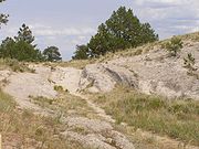
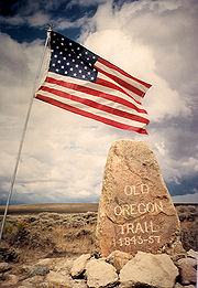
Remnants of the trail in Kansas, Nebraska, Wyoming, Idaho, and Oregon have been listed on the National Register of Historic Places
, and the entire trail is a designated National Historic Trail
(listed as the Oregon National Historic Trail).
and Oregon trail—Independence, Missouri
/Kansas City, Kansas
. Travelers starting in Independence had to ferry across the Missouri River. After following the Santa Fe trail to near present day Topeka, Kansas
they ferried across the Kansas River
to start the trek across Kansas
and points west. Another busy "jumping off point" was St. Joseph, Missouri—established in 1843. In its early days, St. Joseph was a bustling outpost and rough frontier town, serving as one of the last supply points before heading over the Missouri River to the frontier. St. Joseph had good steamboat connections to St. Louis
, Missouri and other ports on the combined Ohio
, Missouri
and Mississippi River
systems. During the busy season there were several ferry boats and steamboats available to transport travelers to the Kansas
shore where they started their travels westward. Before the Union Pacific Railroad
was started in 1865, St. Joseph was the westernmost point in the United States accessible by rail. Other towns used as supply points in Missouri included Old Franklin, Arrow Rock
, and Fort Osage
.
obtained from France the Louisiana Purchase
for fifteen million dollars (equivalent to about $230 million today) which included all the land drained by the Missouri River and roughly doubled the size of U.S. territory. The future states of Iowa
and Missouri
, located west of the Mississippi River
and east of Missouri River, were part of this purchase. The Lewis and Clark Expedition
stopped several times in the future state of Iowa on their 1805–1806 expedition to the west coast. A disputed 1804 treaty between Quashquame
and William Henry Harrison
(future ninth President of the U.S.) that surrendered much of the future state of Illinois
to the U.S. enraged many Sauk (Sac) Indians and led to the 1832 Black Hawk War
. As punishment for the uprising, and as part of a larger settlement strategy, treaties were subsequently designed to remove all Indians from Iowa Territory. Some settlers started drifting into Iowa in 1833. President Martin Van Buren
on July 4, 1838, signed the U.S. Congress laws establishing the Territory of Iowa. Iowa was located opposite the junction of the Platte
and Missouri Rivers and was used by some of the Fur trapper rendezvous traders as a starting point for their supply expeditions. In 1846 the Mormons
, expelled from Nauvoo, Illinois
, traversed Iowa (on part of the Mormon Trail
) and settled temporarily in significant numbers on the Missouri River in Iowa and the future state of Nebraska
at their Winter Quarters near the future city of Omaha, Nebraska
. (See: Missouri River settlements (1846–1854)) The Mormons established about 50 temporary towns including the town of Kernsville Iowa (renamed Council Bluffs, Iowa
in 1852) on the east bank of the Missouri River opposite the mouth of the Platte River
. For those travelers to Oregon, California, and Utah who were bringing their teams to the Platte River junction Kernsville and other towns become major "jumping off places" and supply points. In 1847 the Mormons established three ferries across the Missouri River and others established even more ferries for the spring start on the trail. In the 1850 census there were about 8,000 mostly Mormons tabulated in the large Pottawattamie County, Iowa
District 21. (The original Pottawattamie County was subsequently made into five counties and parts of several more.) By 1854 most of the Mormon towns, farms and villages were largely taken over by non-Mormons as they abandoned them or sold them for not much and continued their migration to Utah. After 1846 the towns of Council Bluffs, Iowa, Omaha, Nebraska
(est. 1852) and other Missouri River towns became major supply points and "jumping off Places" for travelers on the Mormon
, California
, Oregon and other trails west.
 Starting initially in Independence
or Kansas City
in Missouri, the initial trail follows the Santa Fe Trail
into Kansas south of the Wakarusa River
. After crossing Mount Oread at Lawrence
, the trail crosses the Kansas River
by ferry or boats near Topeka
, and crossed the Wakarusa and Vermillion River rivers by ferries. After the Vermillion River the trail angles north west to Nebraska
paralleling the Little Blue River until reaching the south side of the Platte River
. Travel by wagon over the gently rolling Kansas countryside was usually unimpeded except where streams had cut steep banks. There a passage could be made with a lot of shovel work to cut down the banks or the travelers could find an already established crossing.
or Iowa
used ferries and steamboats (fitted out for ferry duty) to cross into towns in Nebraska
. Several towns in Nebraska were used as jumping off places with Omaha
eventually becoming a favorite after about 1855. Fort Kearny
(est. 1848) is about 200 miles (321.9 km) from the Missouri River, and the trail and its many offshoots nearly all converged close to Fort Kearny as they followed the Platte River
west. The army maintained fort was the first chance on the trail to buy emergency supplies, do repairs, get medical aid, or mail a letter. Those on the north side of the Platte could usually wade the shallow river if they needed to visit the fort.
 The Platte River and the North Platte River
in the future states of Nebraska and Wyoming typically had many channels and islands and were too shallow, crooked, muddy and unpredictable for travel even by canoe. The Platte as it pursued its braided paths to the Missouri River was "too thin to plow and too thick to drink". While unusable for transport, the Platte River and North Platte River valleys provided an easily passable wagon corridor going almost due west with access to water, grass, buffalo, and buffalo chip
s for fuel. The trails gradually got rougher as it progressed up the North Platte. There were trails on both sides of the muddy rivers. The Platte was about 1 miles (1.6 km) wide and 2 inches (5.1 cm) to 60 inches (152.4 cm) deep. The water was silty and bad tasting but it could be used if no other water was available. Letting it sit in a bucket for an hour or so or stirring in a 1/4 cup of cornmeal allowed most of the silt to settle out. Those traveling south of the Platte crossed the South Platte River
with its muddy and treacherous crossings using one of about three ferries (in dry years it could sometimes be forded without a ferry) before continuing up the North Platte River valley to Fort Laramie in present-day Wyoming
. After crossing over the South Platte the travelers encountered Ash Hollow
with its steep descent down Windlass Hill.
In the spring in Nebraska and Wyoming the travelers often encountered fierce wind, rain and lightning storms. Until about 1870 travelers encountered hundreds of thousands of bison
migrating through Nebraska on both sides of the Platte River, and most travelers killed several for fresh meat and to build up their supplies of dried jerky
for the rest of the journey. The prairie grass in many places was several feet high with only the hat of a traveler on horseback showing as they passed through the prairie grass. In many years the Indians fired much of the dry grass on the prairie every fall so the only trees or bushes available for firewood were on islands in the Platte river. Travelers gathered and ignited dried buffalo chips
to cook their meals. These burned fast in a breeze, and it could take two or more bushels of chips to get one meal prepared. Those traveling south of the Platte crossed the South Platte fork at one of about three ferries (in dry years it could be forded without a ferry) before continuing up the North Platte River
valley into present-day Wyoming
heading to Fort Laramie. Before 1852 those on the north side of the Platte crossed the North Platte to the south side at Fort Laramie. After 1852 they used Child's Cutoff to stay on the north side to about the present day town of Casper
, Wyoming, where they crossed over to the south side.
Notable landmarks in Nebraska include Courthouse and Jail Rocks
, Chimney Rock
, Scotts Bluff
, and Ash Hollow State Historical Park
.
Today much of the Oregon Trail follows roughly along Interstate 80
from Wyoming to Grand Island
, Nebraska. From there U.S. Highway 30 which follows the Platte River is a better approximate path for those traveling the north side of the Platte. The National Park Service (NPS) gives traveling advice for those who want to follow other branches of the trail.
in the epidemic years (1849–1855) as many thousands of people used the same camping spots with essentially no sewage facilities or adequate sewage treatment. One of the side effects of cholera is acute diarrhea which helps contaminate even more water unless it is isolated and/or treated. The cause of cholera, ingesting the Vibrio cholerae
bacterium from contaminated water, and the best treatment for cholera infections were unknown in this era. Thousands of travelers on the combined California
Oregon and Mormon Trail
succumbed to cholera in the 1849–1855 time period. Most were buried in unmarked graves in Kansas, Nebraska and Wyoming. There are many cases cited where a person would be alive and apparently healthy in the morning and dead by nightfall.
Large cholera death rates worldwide lead to increased efforts to institute good water and sewage treatment in nearly all cities. Despite the enormous costs and increase in city powers (opposed by many) nearly all cities in the developed world instituted good water and sewage treatment facilities. The last significant cholera outbreak in the U. S. occurred in 1911.
if they followed the South Platte River
to one of its last crossings. This branch of the trail passed through present day Julesburg, Colorado
before entering Wyoming. Later settlers to much of the what became the state of Colorado followed the Platte and South Platte Rivers into their settlements there.
the Oregon Trail follows the North Platte River
out of Nebraska into Wyoming. Fort Laramie
, at the junction of the Laramie River
and the North Platte River, was a major stopping point. Fort Laramie was a former fur trading outpost originally named Fort John that was purchased in 1848 by the U.S. Army to protect travelers on the trails. It was the last army outpost till travelers reached the coast.
Fort Laramie was the end of most cholera
outbreaks which killed thousands along the lower Platte and North Platte from 1849 to 1855. Spread by cholera bacteria in fecal contaminated water, cholera caused massive diarrhea, leading to dehydration and death. In those days its cause and treatment were unknown, and it was often fatal—up to 30% of infected people died. It is believed that the swifter flowing rivers in Wyoming helped prevent the germs from spreading.
 After crossing the South Platte the trail continues up the North Platte River
, crossing many small swift flowing creeks. As the North Platte veers to the south the trail crosses the North Platte to the Sweetwater River
valley which heads almost due west. Independence Rock (Wyoming)
is located on the Sweetwater River. The Sweetwater would have to be crossed up to nine times before the trail crosses over the Continental Divide
at South Pass
, Wyoming. From South Pass the trail continues southwest crossing Big Sandy Creek
(about 10 feet (3 m) wide and 1 foot (0.3048 m) deep) before hitting the Green River
. Three to five ferries were in use on the Green during peak travel periods. The swift and treacherous Green River, which eventually empties into the Colorado River
, was usually at high water in July and August, and it was a dangerous crossing. After crossing the Green the main trail continues on in an approximate southwest direction until it encounters the Blacks Fork
of the Green River and Fort Bridger
Wyoming. From Fort Bridger the Mormon Trail
continued southwest following the upgraded Hastings Cutoff
through the Wasatch Mountains. From Fort Bridger, the main trail, comprising several variants, veered northwest over the Bear River Divide and descended to the Bear River
Valley. The trail turned north following the Bear River past the terminus of the Sublette-Greenwood Cutoff at Smiths Fork and on to the Thomas Fork Valley at the present Wyoming-Idaho border.
Over time, two major heavily used cutoffs were established in Wyoming. The Sublette-Greenwood Cutoff was established in 1844 and cut about 70 miles (112.7 km) off the main route. It leaves the main trail about 10 miles (16.1 km) west of South Pass and heads almost due west crossing Big Sandy Creek and then about 45 miles (72.4 km) of waterless of very dusty desert before reaching the Green River near the present town of La Barge
. Ferries here transferred them across the Green River. From there the Sublette-Greenwood Cutoff trail had to cross a mountain range to connect with the main trail near Cokeville, Wyoming
in the Bear River valley.
The Lander Road, formally the Fort Kearney, South Pass, and Honey Lake Wagon Road, was established and built by U.S. government contractors in 1858-59. It was about 80 miles (128.7 km) shorter than the main trail through Fort Bridger with good grass, water, firewood and fishing but it was a much steeper and rougher route, crossing three mountain ranges. In 1859, 13,000 of the 19,000 emigrants traveling to California and Oregon utilized the Lander Road. The traffic in later years is undocumented.
The Lander Road departs the main trail at Burnt Ranch near South Pass, crosses the Continental Divide north of South Pass and reaches the Green River near the present town of Big Piney, Wyoming
. From there the trail followed Big Piney Creek west before passing over the 8800 feet (2,682.2 m) Thompson Pass in the Wyoming Range
. It then crosses over the Smith Fork of the Bear River before ascending and crossing another 8200 feet (2,499.4 m) pass on the Salt River Range
of mountains and then descending into Star Valley
Wyoming. It exited the mountains near the present Smith Fork road about 6 miles (9.7 km) south of the town of Smoot, Wyoming
. The road continued almost due north along the present day Wyoming-Idaho western border through Star Valley. To avoid crossing the Salt River
(which drains into the Snake River
) which runs down Star Valley the Lander Road crossed the river when it was small and stayed west of the Salt River. After traveling down the Salt River valley (Star Valley) about 20 miles (32.2 km) north the road turned almost due west near the present town of Auburn, Wyoming
, and entered into the present state of Idaho along Stump Creek. In Idaho it followed the Stump Creek valley northwest till it crossed the Caribou Mountains
and proceeded past the south end of Grays Lake. The trail then proceeded almost due west to meet the main trail at Fort Hall; alternatively, a branch trail headed almost due south to meet the main trail near the present town of Soda Springs
, Idaho.
Numerous landmarks are located along the trail in Wyoming including Independence Rock
, Ayres Natural Bridge and Register Cliff
.
pioneers departed from the Oregon Trail at Fort Bridger
in Wyoming and followed (and much improved) the rough trail originally recommended by Lansford Hastings
to the Donner Party
in 1846 through the Wasatch Mountains into Utah
. After getting into Utah they immediately started setting up irrigated farms and cities—including Salt Lake City, Utah
. In 1848, the Salt Lake Cutoff
was established by Sam Hensley, and returning members of the Mormon Battalion
providing a path north of the Great Salt Lake
from Salt Lake City back to the California
and Oregon Trails. This cutoff rejoined the Oregon and California Trails near the City of Rocks
near the Utah-Idaho border and could be used by both California and Oregon bound travelers. Located about half way on both the California
and Oregon Trails many thousands of later travelers used Salt Lake City and other Utah cities as an intermediate stop for selling or trading excess goods or tired livestock for fresh livestock, repairs, supplies or fresh vegetables. The Mormons looked on these travelers as a welcome bonanza as setting up new communities from scratch required nearly everything the travelers could afford to part with. The overall distance to California or Oregon was very close to the same whether one "detoured" to Salt Lake City or not. For their own use and to encourage California and Oregon bound travelers the Mormons improved the Mormon Trail from Fort Bridger and the Salt Lake Cutoff trail. To raise much needed money and facilitate travel on the Salt Lake Cutoff they set up several ferries across the Weber
, Bear
and Malad River
s which were used mostly by Oregon or California bound travelers.
valley which it followed northwest into the Thomas Fork area, where the trail crossed over the present day Wyoming line into Idaho. In the Eastern Sheep Creek Hills in the Thomas Fork valley the emigrants encountered Big Hill. Big Hill was a detour caused by an impassable (then) cut the Bear River made through the mountains and had a tough ascent often requiring doubling up of teams and a very steep and dangerous descent. (Much later, U.S. Highway 30, using modern explosives and equipment, was built through this cut). In 1852 Eliza Ann McAuley found and with help developed the McAuley Cutoff which bypassed much of the difficult climb and descent of Big Hill. About 5 miles (8 km) on they passed present day Montpelier
, Idaho which is now the site of The National Oregon-California Trail Center. The trail follows the Bear River northwest to present day Soda Springs, Idaho
. The soda springs here were a favorite attraction of the pioneers who marveled at the hot carbonated water and chugging "steamboat" springs. Many stopped and did their laundry in the hot water as there was usually plenty of good grass and fresh water available. Just west of Soda Springs the Bear River turns southwest as it heads for The Great Salt Lake
and the main trail turns northwest to follow the Portneuf River
valley to Fort Hall
Idaho. Fort Hall was an old fur trading post located on the Snake River
. It was established in 1832 by Nathaniel Jarvis Wyeth
and company and later sold in 1837 to the British Hudson's Bay Company
. At Fort Hall nearly all travelers were given some aid and supplies if they were available and needed. Mosquitoes were constant pests and travelers often mention that their animals were covered with blood from the bites. The route from Fort Bridger to Fort Hall is about 210 miles (338 km), taking nine to twelve days.
At Soda Springs was one branch of Lander Road (established and built with government contractors in 1858) which had gone west from near South Pass, over the Salt River Mountains and down Star Valley before turning west near present day Auburn
, Wyoming and entering Idaho. From there it proceeded northwest into Idaho up Stump Creek canyon for about ten miles (16 km). One branch turned almost 90 degrees and proceeded southwest to Soda Springs. Another branch headed almost due west past Gray's Lake to rejoin the main trail about 10 miles (16.1 km) west of Fort Hall.
On the main trail about 5 miles (8 km) west of Soda Springs Hudspeth's Cutoff (established 1849 and used mostly by California trail users) took off from the main trail heading almost due west, bypassing Fort Hall. It rejoined the California Trail
at Cassia Creek near the City of Rocks
. Hudspeth's Cutoff had five mountain ranges to cross and took about the same amount of time as the main route to Fort Hall but many took it thinking it was shorter. Its main advantage was that it helped spread out the traffic during peak periods, making more grass available.
West of Fort Hall the main trail traveled about 40 miles (64.4 km) on the south side of the Snake River southwest past American Falls, Massacre Rocks, Register Rock and Coldwater Hill near present day Pocatello
, Idaho. Near the junction of the Raft River
and Snake River the California Trail diverged from the Oregon Trail at another Parting of the Ways junction. Travellers left the Snake River and followed Raft River about 65 miles (104.6 km) southwest past present day Almo
, Idaho. This trail then passed through the City of Rocks
and over Granite Pass where it went southwest along Goose Creek, Little Goose Creek, and Rock Spring Creek. It went about 95 miles (152.9 km) through Thousand Springs Valley, West Brush Creek, and Willow Creek, before arriving at the Humboldt River
in northeastern Nevada near present day Wells
. The California Trail proceeded west down the Humboldt before reaching and crossing the Sierra Nevadas.
There were only a few places where the Snake River has not buried itself deep in a canyon. There were few spots where the river slowed down enough to make a crossing possible. Two of these fords were near Fort Hall, where travelers on the Oregon Trail North Side Alternate (established about 1852) and Goodale's Cutoff (established 1862) crossed the Snake to travel on the north side. Nathaniel Wyeth, the original founder of Fort Hall in 1834, writes in his diary that they found a ford across the Snake River 4 miles (6.4 km) southwest of where he founded Fort Hall. Another possible crossing was a few miles upstream of Salmon Falls where some intrepid travelers floated their wagons and swam their stock across to join the north side trail. Some lost their wagons and teams over the falls. The trails on the north side joined the trail from Three Island Crossing about 17 miles (27.4 km) west of Glenns Ferry on the north side of the Snake River.
Goodale's Cutoff, established in 1862 on the north side of the Snake River, formed a spur of the Oregon Trail. This cutoff had been used as a pack trail by Indians and fur traders, and emigrant wagons traversed parts of the eastern section as early as 1852. After crossing the Snake River the 230 miles (370.1 km) cutoff headed north from Fort Hall toward Big Southern Butte following the Lost River
part of the way. It passed near the present-day town of Arco
, Idaho and wound through the northern part of Craters of the Moon National Monument. From there it went southwest to Camas Prairie
and ended at Old Fort Boise on the Boise River
. This journey typically took two to three weeks and was noted for its very rough, lava restricted roads and extremely dry climate, which tended to dry the wooden wheels on the wagons, which caused the iron rims to fall off the wheels. Loss of wheels caused many wagons to be abandoned along the route. It rejoined the main trail east of Boise. Goodale's Cutoff is visible at many points along U.S. Highway 20, U.S. Highway 26 and U.S. Highway 93 between Craters of the Moon National Monument and Carey
, Idaho.
 From the present site of Pocatello
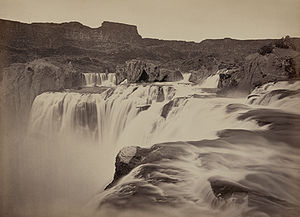
the trail proceeded almost due west on the south side of the Snake River for about 180 miles (289.7 km). On this route they passed Cauldron Linn rapids, Shoshone Falls
, two falls near the present city of Twin Falls
, Idaho, and Upper Salmon Falls on the Snake River. At Salmon Falls there were often a hundred or more Indians fishing who would trade for their salmon—a welcome treat. The trail continued west to Three Island Crossing (near present day Glenns Ferry
, Idaho). Here most emigrants used the divisions of the river caused by three islands to cross the difficult and swift Snake River by ferry or by driving or sometimes floating their wagons and swimming their teams across. The crossings were doubly treacherous because there were often hidden holes in the river bottom which could overturn the wagon or ensnarl the team, sometimes with fatal consequences. Before ferries were established there were several drownings here nearly every year.
The north side of the Snake had better water and grass than the south. The trail from Three Island Crossing to Old Fort Boise was about 130 miles long. The usually lush Boise River valley was a welcome relief. The next crossing of the Snake River was near Old Fort Boise. This last crossing of the Snake could be done on bull boats while swimming the stock across. Others would chain a large string of wagons and teams together. The theory was that the front teams, usually oxen, would get out of water first and with good footing help pull the whole string of wagons and teams across. How well this worked in practice is not stated. Often young Indian boys were hired to drive and ride the stock across the river—they knew how to swim, unlike many pioneers. Today's Idaho Interstate 84
roughly follows the Oregon Trail till it leaves the Snake River near Burley
, Idaho. From there Interstate 86
to Pocatello roughly approximates the trail. Highway 30 roughly follows the path of the Oregon Trail from there to Montpelier
, Idaho.
Starting in about 1848 the South Alternate of Oregon Trail (also called the Snake River Cutoff) was developed as a spur off the main trail. It bypassed the Three Island Crossing and continued traveling down the south side of the Snake River. It rejoined the trail near present day Ontario
, Oregon. It hugged the southern edge of the Snake River canyon and was a much rougher trail with poorer water and grass, requiring occasional steep descents and ascents with the animals down into the Snake River canyon to get water. Travellers on this route avoided two dangerous crossings of the Snake River. Today's Idaho State Route 78 roughly follows the path of the South Alternate route of the Oregon Trail.
In 1869 the Central Pacific established Kelton, Utah
as a railhead and the terminus of the western mail was moved from Salt Lake City. The Kelton Road became important as a communication and transportation road to the Boise Basin.
ford near Old Fort Boise the weary travelers traveled across what would become the state of Oregon
. The trail then went to the Malheur River
and then past Farewell Bend
on the Snake River, up the Burnt River
canyon and northwest to the La Grande
valley before coming to the Blue Mountains
. In 1843 settlers cut a wagon road over these mountains making them passable for the first time to wagons. The trail went to the Whitman Mission near Fort Nez Perce in Washington until 1847 when the Whitmans were killed by Native Americans. At Fort Nez Perce some built rafts or hired boats and started down the Columbia; others continued west in their wagons until they reached The Dalles
. After 1847 the trail bypassed the closed mission and headed almost due west to present day Pendleton
, Oregon, crossing the Umatilla River
, John Day River
, and Deschutes River before arriving at The Dalles. Interstate 84
in Oregon roughly follows the original Oregon Trail from Idaho to The Dalles.
Arriving at the Columbia at The Dalles and stopped by the Cascade Mountains and Mount Hood
, some gave up their wagons or disassembled them and put them on boats or rafts for a trip down the Columbia River
. Once they transited the Cascade's Columbia River Gorge
with its multiple rapids and treacherous winds they would have to make the 1.6 miles (2.6 km) portage around the Cascade Rapids before coming out near the Willamette River
where Oregon City
, Oregon was located. The pioneer's livestock could be driven around Mount Hood on the narrow, crooked and rough Lolo Pass
.
Several Oregon Trail branches and route variations led to the Willamette Valley
. The most popular was the Barlow Road
, which was carved though the forest around Mount Hood from The Dalles in 1846 as a toll road at $5.00 per wagon and 10 cents per head of livestock. It was rough and steep with poor grass but still cheaper and safer than floating goods, wagons and family down the dangerous Columbia River.
In Central Oregon there was the Santiam Wagon Road
(established 1861), which roughly parallels Oregon Highway 20 to the Willamette Valley. The Applegate Trail
(established 1846) cutting off the California Trail
from the Humboldt River
in Nevada crossed part of California before cutting north to the south end of the Willamette Valley. U.S. Route 99
and Interstate 5
through Oregon roughly follow the original Applegate Trail.
s commonly used at that time in the eastern United States
and on the Santa Fe Trail
. Their 6000 pounds (2,721.6 kg) freight capacity was larger than needed, and the large teams (8 to 10 animals) these wagons required could not navigate the tight corners often found on the Oregon Trail.
This led to the rapid development of prairie schooners
. This wagon was approximately half the size of the larger Conestoga, weighed about 1300 pounds (589.7 kg) empty with about 2500 pounds (1,134 kg) of capacity and about 88 ft2 of storage space in an 11 feet (3.4 m)-long, 4 feet (1.2 m)-wide, by 2 foot (0.6096 m)-high box. These wagons could be easily pulled by 4 to 6 oxen or 6 to 10 mules. Extra animals were often recommended because animals could stray or become injured or die on the trip. Often late in the trip mixed teams that included dairy cows and riding ponies were sometimes hitched up to make a usable team. The wagons were manufactured in quantity by companies like Studebaker
, with new wagons costing between $85 and $170. The cotton canvas covers of the wagons were doubled and treated with linseed oil
to help keep out the rain, dust and wind, though the covers tended to leak rain and dust eventually. The typical wagon with 40 to 50 in (1 to 1.3 m) diameter wheels could easily move over rough ground and rocks without high centering and even over most tree stumps if required. The wooden wheels were protected with an iron rim typically about 1.5 inches (3.81 cm) wide. These iron tires were installed hot so they would shrink tightly onto the wood wheel when they cooled. Nevertheless it was advisable to soak the wheel in water periodically as the desert air could dry the wheel so much that the iron tire would fall off. In practice it was found that the standard farm wagon built by a company or wagon maker (wainwright) of good reputation usually worked almost as well as prairie schooners and had only to be fitted with wooden bows and a canvas cover to be ready. Wagons were generally reliable if maintained, but they sometimes broke down and had to be repaired or abandoned along the way. Broken axles and broken wagon tongues were two of the most common problems, and replacements were created out of whatever wood was available. Abandoned wagons were typically scavenged for needed parts. One wagon could carry enough food for six months' travel for four or five travelers as well as a short list of household and luxury items.
It is estimated that about seventy percent (or more) of the wagons traveling west were pulled by oxen; mule teams were a strong second choice at 20–30%, and initially there were almost no horse-pulled wagons. This was true for many reasons. An ox team was about 10% slower than a mule or horse-pulled wagon (about 2–3 miles/hour). However, they were cheaper to buy ($25 to $85 per yoke versus up to $600 or more for six horses), easier to train, could pull more, survived better on the sparse grass often found along the trail, did not require oats or grain, and were often tamer and easier to handle after they were trained. Novices could usually learn to handle a trained ox team in about a week. Oxen could usually be turned loose at night and easily rounded up in the mornings. Mules and horses typically required herding day and night and often had to be staked out on a rope or hobbled. Oxen were usually easier to find and catch, and the Indians were usually less interested in stealing them. Mules were the second choice. They were about as fast as a horse and could survive well on the grazing found along the way, and worked well when trained. Trained mules were hard to find, and mules were difficult to handle until trained by an experienced mule skinner, which could take two months. In later years, horses were chosen more often because they were about 10% faster and the oats and grain required to keep them fit for months of continuous work could by then be bought along the way.
The ox drivers walked alongside the left side of their oxen team and used the voice commands "gee" (right) and "haw" (left) and a whip to guide them. Mules were often guided by riding one that was hooked to the wagon (typically the left hand wheel mule) and handling the reins from there. Whips were seldom used to actually whip the animals but were used to get the animal's attention by snapping them in the air.
The amount of food required was lessened if beef cattle, calves or sheep were taken for a walking food supply. Prior to the 1870s there were vast herds of buffalo
in Nebraska which provided fresh meat and jerky for the trip. In general, wild game could not be depended on for a regular source of food, but when found it was relished as a welcome change in a monotonous diet. Travelers could hunt antelope
, buffalo, sage hen
s, trout
, and occasionally elk
, bear, duck, geese, salmon and deer along the trail. Most travelers carried a rifle or shotgun and ammunition for hunting game and for protection against snakes and Indian attacks. When they got to the Snake River and Columbia River areas they would often trade with the Indians for salmon. The Indians in Oregon traded potatoes and other vegetables they had learned to grow from the missionaries. Some families took along milk cows, goats, and chickens (penned in crates tied to the wagons). Additional food like pickles, canned butter, cheese or pickled eggs were occasionally carried, but canned goods were expensive and food preservation was primitive, so few items could be safely kept for the four to six month duration of the trip.
Cooking along the trail was done over a campfire. Fuels used were wood, buffalo chips, willow or sagebrush. Flint and steel were used to start fires. Some carried matches in water-tight containers. Fire was borrowed from a neighbor for ease of starting. Cooking required simple cooking utensils such as butcher knives, large spoons, spatulas, ladles, Dutch oven
s, pots and pans, grills, spits, coffee pots and an iron tripod to suspend the pans and pots over the fire. Some brought small stoves, but these were often jettisoned along the way as being too heavy and unnecessary. Wooden or canvas buckets were brought for carrying water, and most travelers carried canteens or water bags for daily use. A ten gallon water barrel was needed, but it was usually kept nearly empty to minimize weight (some water had to be kept in it to prevent it from drying out and losing its water tightness). It was only filled for long waterless stretches. Some brought a new invention: an India Rubber combination mattress and water carrier.
Travelers brought books, Bibles, trail guides, and writing quills, ink and paper for letters (about one in 200 kept a diary).
Belts and folding knives were carried by nearly all men and boys. Awls, scissors, pins, needles and thread for mending were required. Spare leather was used for repairs to shoes, harnesses, and other equipment. Some used goggles to keep dust out of the eyes. Storage boxes were ideally the same height so they could be arranged to give a flat surface inside the wagon for a sleeping platform.
Saddles, bridles, hobbles, and ropes were needed if the party had a horse or riding mule, and many men did. Extra harnesses and spare wagon parts were often carried. Most carried steel shoes for oxen, mules or horses. Tar was carried to help repair an injured ox's hoof.
Goods, supplies and equipment were often shared by fellow travelers. Items that were forgotten, broken or worn out could be bought from a fellow traveler, post or fort along the way. New iron shoes for horses, mules and oxen were put on by blacksmiths found along the way. Equipment repairs and other goods could be procured from blacksmith shops established at some forts and some ferries. Emergency supplies, repairs and livestock were often provided by local residents in Oregon, California, and Utah for late travelers on the trail who were hurrying to beat the snow.
Non-essential items were often abandoned to lighten the load, or in case of emergency. Many travelers would salvage discarded items, picking up essentials or leaving their behind their lower quality item when a better one was found abandoned along the road. Some profited by collecting discarded items and hauling them back to jumping off places and reselling them. In the early years Mormons sent scavenging parties back along the trail to salvage as much iron and other supplies as possible and haul it to Salt Lake City, where supplies of all kinds were needed. Others would use discarded wagons, wheels and furniture as firewood. During the 1849 gold rush, Fort Laramie was known as "Camp Sacrifice" because of the large amounts merchandise discarded nearby. Travelers had pushed along the relatively easy path to Fort Laramie with their luxury items but discarded them before the difficult mountain crossing ahead and after discovering that many items could be purchased at the forts or located for free along the way. Some travelers carried their excess goods to Salt Lake City to be sold.
Professional tools used by blacksmiths, carpenters, and farmers were carried by nearly all. Shovels, crow bars, picks, hoes, mattocks, saws, hammers, axes and hatchets were used to clear or make a road through trees or brush, cut down the banks to cross a wash or steep banked stream, build a raft or bridge, or repair the wagon. In general as little road work as possible was done. Travel was often along the top of ridges to avoid the brush and washes common in many valleys.
Some of the trail statistics for the early years were recorded by the U.S. Army at Fort Laramie, Wyoming, from about 1849 to 1855. None of these original statistical records have been found—the Army lost them or destroyed them. There are only some partial written copies of the Army records and notes recorded in several diaries. Emigration to California spiked considerably with the 1849 gold rush
. Following the discovery of gold, California remained the destination of choice for most emigrants on the trail up to 1860, with almost 200,000 people traveling there between 1849 and 1860.
Travel diminished after 1860 as the Civil War caused considerable disruptions on the trail. Many of the people on the trail in 1861–1863 were fleeing the war and its attendant drafts in both the south and the north. Trail historian Merrill J. Mattes has estimated the number of emigrants for 1861–1867 given in the total column of the above table. But these estimates may well be low since they only amount to an extra 125,000 people, and the 1870 census shows that over 200,000 additional people (ignoring most of California's population increase which had an excellent sea and rail connections across Panama by then) showed up in all the states served by the California/Oregon/Mormon/Bozeman Trail(s) and its offshoots. Mormon emigration records after 1860 are reasonably accurate as newspaper and other accounts in Salt Lake City give most of the names of emigrants arriving each year from 1847 to 1868. Gold and silver strikes in Colorado, Oregon, Idaho, Nevada and Montana caused a considerable increase in people using the trails, often in directions different than the original trail users.
Though the numbers are significant in the context of the times, far more people chose to remain at home in the 31 states. Between 1840 and 1860, the population of the United States rose by 14 million, yet only about 300,000 decided to make the trip. Many that went were between the ages 12 and 24. Between 1860 and 1870 the U.S. population increased by seven million, with about 350,000 of this increase being in the Western states. Many were discouraged by the cost, effort and danger of the trip. Western scout Kit Carson
reputedly said, "The cowards never started and the weak died on the way." According to several sources 3–10% of the emigrants are estimated to have perished on the way west.
These census numbers show a 363,000 population increase in the western states and territories between 1860 and 1870. Some of this increase is because of a high birth rate in the western states and territories but most is from emigrants moving from the east to the west and new immigration from Europe. Much of the increase in California and Oregon is from emigration by ship as there were fast and reasonably low cost transportation via east and west coast steamships and the Panama Railroad after 1855. The census numbers imply at least 200,000 emigrants (or more) used some variation of the California/Oregon/Mormon/Bozeman trails to get to their new homes between 1860 and 1870.
The route west was arduous and with many dangers, but the number of deaths on the trail is not known with any precision; there are only wildly varying estimates. Estimating is difficult because of the common practice of burying people in unmarked graves that were intentionally disguised to avoid them being dug up by animals or Indians. Graves were often put in the middle of a trail and then run over by the livestock to make them difficult to find. Disease was the main killer of trail travelers; cholera killed up to 3% of all travelers in the epidemic years from 1849 to 1855.
Indian attacks increased significantly after 1860 when most of the army troops were withdrawn and miners and ranchers began fanning out all over the country, often encroaching on Indian territory. Increased attacks along the Humboldt led to most travelers taking the Central Nevada Route. The Goodall cutoff was developed in Idaho in 1862 which kept Oregon bound travelers away from much of the Indian trouble nearer the Snake River. Other trails were developed that traveled further along the South Platte to avoid local Indian hot spots.
Other common causes of death included hypothermia
, drowning in river crossings, getting run over by wagons, and accidental gun deaths. Drownings probably peaked in 1849 and 1850 when young impatient and pushy men were the predominant population on the trail. Later more family groups started traveling as well as many more ferries and bridges were being put in, and fording a dangerous river became much less common and dangerous. Surprisingly few people were taught to swim in this era. Being run over was a major cause of death, despite the wagons only averaging 2–3 miles per hour. The wagons could not easily be stopped, and people, particularly children, were often trying to get on and off the wagons while they were moving—not always successfully. Another hazard was a dress getting caught in the wheels and pulling the person under. Accidental shootings declined significantly after Fort Laramie as people became more familiar with their weapons and often just left them in their wagons. Carrying around a ten pound rifle all day soon became tedious and usually unnecessary as the perceived Indian threat faded and hunting opportunities receded.
A significant number of travelers were suffering from scurvy
by the end of their trips. Their typical flour and salted pork/bacon diet had very little vitamin C
in it. The diet in the mining camps was also typically low in fresh vegetables and fruit, which indirectly led to early deaths of many of the inhabitants. Some believe that scurvy deaths may have rivaled cholera as a killer, with most deaths occurring after the victim reached California. Many understood the importance of a diet that included fresh vegetables and fruit, and how to prevent scurvy was common knowledge in some circles but far from universally known or taught. Chinese travelers with their insistence on many vegetables in their diet fared much better.
Miscellaneous deaths included deaths by homicides, lightning strikes, childbirth, stampedes, snake bites, flash floods, falling trees, and kicks by animals. According to an evaluation by John Unruh, a 4% death rate or 16,000 out of 400,000 total pioneers on all trails may have died on the trail.
The story of the Oregon Trail inspired a popular educational computer game of the same name, The Oregon Trail
. The game became widely popular in the 1980s and early 1990s. Several sequels to the game were also released, such as The Oregon Trail II, The Yukon Trail, and The Amazon Trail
. The game resurfaced in 2008 when Gameloft
created an updated version for cell phones.
The Oregon Trail was briefly made into a television series that ran from September 22, 1977 – October 26, 1977, on NBC. The show starred Rod Taylor, Tony Becker, Darleen Carr, Charles Napier
, and Ken Swofford. Although it was canceled after six episodes, the remaining seven episodes were still aired on BBC 2 in the U.K.
In June 2010, the entire series was released on DVD in the USA by Timeless.
Missouri River
The Missouri River flows through the central United States, and is a tributary of the Mississippi River. It is the longest river in North America and drains the third largest area, though only the thirteenth largest by discharge. The Missouri's watershed encompasses most of the American Great...
to valleys in Oregon
Oregon
Oregon is a state in the Pacific Northwest region of the United States. It is located on the Pacific coast, with Washington to the north, California to the south, Nevada on the southeast and Idaho to the east. The Columbia and Snake rivers delineate much of Oregon's northern and eastern...
and locations in between.
After 1840 steam-powered riverboat
Riverboat
A riverboat is a ship built boat designed for inland navigation on lakes, rivers, and artificial waterways. They are generally equipped and outfitted as work boats in one of the carrying trades, for freight or people transport, including luxury units constructed for entertainment enterprises, such...
s and steamboat
Steamboat
A steamboat or steamship, sometimes called a steamer, is a ship in which the primary method of propulsion is steam power, typically driving propellers or paddlewheels...
s traversing up and down the Ohio
Ohio River
The Ohio River is the largest tributary, by volume, of the Mississippi River. At the confluence, the Ohio is even bigger than the Mississippi and, thus, is hydrologically the main stream of the whole river system, including the Allegheny River further upstream...
, Mississippi
Mississippi River
The Mississippi River is the largest river system in North America. Flowing entirely in the United States, this river rises in western Minnesota and meanders slowly southwards for to the Mississippi River Delta at the Gulf of Mexico. With its many tributaries, the Mississippi's watershed drains...
and Missouri
Missouri River
The Missouri River flows through the central United States, and is a tributary of the Mississippi River. It is the longest river in North America and drains the third largest area, though only the thirteenth largest by discharge. The Missouri's watershed encompasses most of the American Great...
rivers sped settlement and development in the flat region from the Appalachian mountains to the American Rocky Mountains. The boats serviced the jumping off points for wagon trains that crossed the mountains headed to rich farmlands in Oregon and California. With disputes with Mexico and Britain settled by 1848, the new lands proved highly attractive. Getting there by sea meant a very long trip around South America, a journey which was expensive and dangerous and took longer than walking. It flourished from the 1840s until the coming of the railroad at the end of the 1860s. The trip on foot took four to six months. It was the oldest of the northern commercial and emigrant trail
Emigrant Trail
The Emigrant Trails were the northern networks of overland wagon trails throughout the American West, used by emigrants from the eastern United States to settle lands west of the Interior Plains during the overland migrations of the mid-19th century...
s and was originally discovered and used by fur trappers and traders in the fur trade
Fur trade
The fur trade is a worldwide industry dealing in the acquisition and sale of animal fur. Since the establishment of world market for in the early modern period furs of boreal, polar and cold temperate mammalian animals have been the most valued...
from about 1811 to 1840. In its earliest days much of the future Oregon Trail was not passable to wagons but was passable everywhere only to men walking or riding horses and leading mule train
Mule train
Mule train can refer to:*A connected line of mules*Mule Train, 1949 popular song written by Johnny Lange, Hy Heath, Doc Tommy Scott and Fred Glickman...
s. By 1836, when the first Oregon wagon trains were organized at Independence, Missouri
Independence, Missouri
Independence is the fourth largest city in the U.S. state of Missouri, and is contained within the counties of Jackson and Clay. It is part of the Kansas City Metropolitan Area...
, the trail had been improved so much that it was possible to take wagons to Fort Hall
Fort Hall
Fort Hall, sitting athwart the end of the common stretch shared by the three far west emigrant trails was a 19th century outpost in the eastern Oregon Country, which eventually became part of the present-day United States, and is located in southeastern Idaho near Fort Hall, Idaho...
, Idaho
Idaho
Idaho is a state in the Rocky Mountain area of the United States. The state's largest city and capital is Boise. Residents are called "Idahoans". Idaho was admitted to the Union on July 3, 1890, as the 43rd state....
. By 1843 a rough wagon trail had been cleared to The Dalles, Oregon
The Dalles, Oregon
The Dalles is the largest city and county seat of Wasco County, Oregon, United States. The name of the city comes from the French word dalle The Dalles is the largest city and county seat of Wasco County, Oregon, United States. The name of the city comes from the French word dalle The Dalles is...
, and by 1846 all the way around Mount Hood
Mount Hood
Mount Hood, called Wy'east by the Multnomah tribe, is a stratovolcano in the Cascade Volcanic Arc of northern Oregon. It was formed by a subduction zone and rests in the Pacific Northwest region of the United States...
to the Willamette Valley
Willamette Valley
The Willamette Valley is the most populated region in the state of Oregon of the United States. Located in the state's northwest, the region is surrounded by tall mountain ranges to the east, west and south and the valley's floor is broad, flat and fertile because of Ice Age conditions...
in the state of Oregon. What became called the Oregon Trail was complete even as improved roads, "cutouts", ferries and bridges made the trip faster and safer almost every year.
The eastern part of the Oregon Trail spanned part of the future state of Kansas
Kansas
Kansas is a US state located in the Midwestern United States. It is named after the Kansas River which flows through it, which in turn was named after the Kansa Native American tribe, which inhabited the area. The tribe's name is often said to mean "people of the wind" or "people of the south...
and nearly all of what are now the states of Nebraska
Nebraska
Nebraska is a state on the Great Plains of the Midwestern United States. The state's capital is Lincoln and its largest city is Omaha, on the Missouri River....
and Wyoming
Wyoming
Wyoming is a state in the mountain region of the Western United States. The western two thirds of the state is covered mostly with the mountain ranges and rangelands in the foothills of the Eastern Rocky Mountains, while the eastern third of the state is high elevation prairie known as the High...
. The western half of the trail spanned most of the future states of Idaho and Oregon. From various "jumping off points" in Missouri, Iowa or Nebraska
Nebraska Territory
The Territory of Nebraska was an organized incorporated territory of the United States that existed from May 30, 1854, until March 1, 1867, when the final extent of the territory was admitted to the Union as the State of Nebraska. The Nebraska Territory was created by the Kansas–Nebraska Act of 1854...
, the routes converged along the lower Platte River Valley
Platte River
The Platte River is a major river in the state of Nebraska and is about long. Measured to its farthest source via its tributary the North Platte River, it flows for over . The Platte River is a tributary of the Missouri River, which in turn is a tributary of the Mississippi River which flows to...
, near Fort Kearny
Fort Kearny
Fort Kearny was a historic outpost of the United States Army founded in 1848 in the western U.S. during the middle and late 19th century. The outpost was located along the Oregon Trail near present-day Kearney, Nebraska, which took its name from the fort .-Origins and various missions of the...
, Nebraska Territory. Small steamboats carrying fur traders navigated the Missouri River up to the Yellowstone River
Yellowstone River
The Yellowstone River is a tributary of the Missouri River, approximately long, in the western United States. Considered the principal tributary of the upper Missouri, the river and its tributaries drain a wide area stretching from the Rocky Mountains in the vicinity of the Yellowstone National...
in Montana as early as 1832. Larger steamboats traveling much above St. Joseph were blocked until dredging opened a bigger channel in 1852.
Oregon Trail travelers could purchase repairs, new supplies, fresh teams and help from fort-trading posts such as Fort Kearny and Fort Laramie. Jim Bridger
Jim Bridger
James Felix "Jim" Bridger was among the foremost mountain men, trappers, scouts and guides who explored and trapped the Western United States during the decades of 1820-1850, as well as mediating between native tribes and encroaching whites...
's Fort Bridger
Fort Bridger
Fort Bridger was originally a 19th century fur trading outpost established in 1842 on Blacks Fork of the Green River and later a vital resupply point for wagon trains on the Oregon Trail, California Trail and Mormon Trail. The Army established a military post here in 1858 during the Utah War until...
and Hudson's Bay Company-owned Fort Hall
Fort Hall
Fort Hall, sitting athwart the end of the common stretch shared by the three far west emigrant trails was a 19th century outpost in the eastern Oregon Country, which eventually became part of the present-day United States, and is located in southeastern Idaho near Fort Hall, Idaho...
and Fort Boise
Fort Boise
Fort Boise refers to two different locations in southwestern Idaho. The first was a Hudson's Bay Company trading post near the Snake River on the Oregon border, dating from the era when Idaho was part of the fur company's Columbia District. After several rebuilds, it was ultimately abandoned in...
in Idaho; Fort Nez Perces
Fort Nez Percés
Fort Nez Percés, sometimes also spelled Fort Nez Percé , named after the Nez Perce people and later known as Fort Walla Walla, was a fortified British fur trading post on the Columbia River on the territory of modern-day Wallula, Washington...
(Fort Walla Walla) in Oregon and Fort Vancouver
Fort Vancouver
Fort Vancouver was a 19th century fur trading outpost along the Columbia River that served as the headquarters of the Hudson's Bay Company in the company's Columbia District...
in Washington. Other supplies, fresh teams and repairs could often be obtained from temporary trading posts and ferries set up by entrepreneurs along the trail during the traveling season. From the early to mid 1830s, but especially after the organization of the first large wagon train
Wagon train
A wagon train is a group of wagons traveling together. In the American West, individuals traveling across the plains in covered wagons banded together for mutual assistance, as is reflected in numerous films and television programs about the region, such as Audie Murphy's Tumbleweed and Ward Bond...
s in Independence
Independence, Missouri
Independence is the fourth largest city in the U.S. state of Missouri, and is contained within the counties of Jackson and Clay. It is part of the Kansas City Metropolitan Area...
, Missouri in 1841 and through the epoch years 1846–1869 the Oregon Trail and its many off shoots was used by about 400,000 settlers, ranchers, farmers, miners, and businessmen and their families. The eastern half of the trail was also used by travelers on the California Trail
California Trail
The California Trail was an emigrant trail of about across the western half of the North American continent from Missouri River towns to what is now the state of California...
(from 1843), Bozeman Trail
Bozeman Trail
The Bozeman Trail was an overland route connecting the gold rush territory of Montana to the Oregon Trail. Its most important period was from 1863-1868. The flow of pioneers and settlers through territory of American Indians provoked their resentment and caused attacks. The U.S. Army undertook...
(from 1863), and Mormon Trail
Mormon Trail
The Mormon Trail or Mormon Pioneer Trail is the 1,300 mile route that members of The Church of Jesus Christ of Latter-day Saints traveled from 1846 to 1868...
(from 1847) which used many of the same eastern trails before turning off to their separate destinations.
Once the first transcontinental railroad
First Transcontinental Railroad
The First Transcontinental Railroad was a railroad line built in the United States of America between 1863 and 1869 by the Central Pacific Railroad of California and the Union Pacific Railroad that connected its statutory Eastern terminus at Council Bluffs, Iowa/Omaha, Nebraska The First...
by the Union Pacific and the Central Pacific
Central Pacific Railroad
The Central Pacific Railroad is the former name of the railroad network built between California and Utah, USA that formed part of the "First Transcontinental Railroad" in North America. It is now part of the Union Pacific Railroad. Many 19th century national proposals to build a transcontinental...
was completed in 1869, the use of this trail by long distance travelers fell off because the train took seven days and at $69 was much cheaper. Travelers going to Oregon could take the train to California and catch a coastal steamer to Oregon. By 1883 the Northern Pacific Railroad had reached Portland
Portland, Oregon
Portland is a city located in the Pacific Northwest, near the confluence of the Willamette and Columbia rivers in the U.S. state of Oregon. As of the 2010 Census, it had a population of 583,776, making it the 29th most populous city in the United States...
, Oregon, and thereafter there were fewer and fewer wagon trains each year along the western trail. The legacy persisted as highways such as Interstate 80
Interstate 80
Interstate 80 is the second-longest Interstate Highway in the United States, following Interstate 90. It is a transcontinental artery running from downtown San Francisco, California to Teaneck, New Jersey in the New York City Metropolitan Area...
followed the same course westward and passed through towns originally established to service the Oregon Trail.
To complete the journey in one traveling season most travelers left in April to May—as soon as there was enough grass for forage for the animals and the trails dried out. To meet the constant need for water, grass, and fuel for campfires the trail followed various rivers and streams across the continent. The network of trails required little initial preparation to be made passable for wagons. People using the trail traveled in wagons, pack trains, on horseback, on foot, and sometimes by raft or boat to establish new farms, lives, and businesses in the Oregon Country.
Lewis and Clark Expedition
In 1803, President Thomas JeffersonThomas Jefferson
Thomas Jefferson was the principal author of the United States Declaration of Independence and the Statute of Virginia for Religious Freedom , the third President of the United States and founder of the University of Virginia...
issued the following instructions to Meriwether Lewis
Meriwether Lewis
Meriwether Lewis was an American explorer, soldier, and public administrator, best known for his role as the leader of the Lewis and Clark Expedition also known as the Corps of Discovery, with William Clark...
: "The object of your mission is to explore the Missouri river, & such principal stream of it, as, by its course & communication with the waters of the Pacific Ocean, whether the Columbia, Oregon, Colorado and/or other river may offer the most direct & practicable water communication across this continent, for the purposes of commerce." Although Lewis and William Clark found a path to the Pacific Ocean, it was not until 1859 that a direct and practicable route, the Mullan Road
Mullan Road
Mullan Road was the first wagon road to cross the Rocky Mountains to the Inland of the Pacific Northwest. It was built by US Army Lieut. John Mullan between the spring of 1859 and summer 1860. It led from Fort Benton, Montana, the navigational head of the Missouri River to Fort Walla Walla,...
, connected the Missouri River to the Columbia River
Columbia River
The Columbia River is the largest river in the Pacific Northwest region of North America. The river rises in the Rocky Mountains of British Columbia, Canada, flows northwest and then south into the U.S. state of Washington, then turns west to form most of the border between Washington and the state...
.
Rocky Mountains
The Rocky Mountains are a major mountain range in western North America. The Rocky Mountains stretch more than from the northernmost part of British Columbia, in western Canada, to New Mexico, in the southwestern United States...
, Lemhi Pass
Lemhi Pass
Lemhi Pass is a high mountain pass in the Beaverhead Mountains, part of the Bitterroot Range in the Rocky Mountains The pass lies on the Montana-Idaho border on the continental divide, at an elevation of 7373 feet above sea level.-History:...
and Lolo Pass
Lolo Pass (Idaho-Montana)
Lolo Pass, elevation , is a mountain pass in the United States, in the Bitterroot Range of the northern Rocky Mountains. It is on the border between the states of Montana and Idaho, approximately west-southwest of Missoula, Montana....
, turned out to be much too difficult for wagons to pass through without considerable road work. On the return trip in 1806 they traveled from the Columbia River to the Snake River
Snake River
The Snake is a major river of the greater Pacific Northwest in the United States. At long, it is the largest tributary of the Columbia River, the largest North American river that empties into the Pacific Ocean...
and the Clearwater River
Clearwater River (Idaho)
The Clearwater River is a river in north central Idaho, which flows westward from the Bitterroot Mountains along the Idaho-Montana border, and joins the Snake River at Lewiston. In October 1805, the Lewis and Clark Expedition descended the Clearwater River in dugout canoes, putting in at "Canoe...
over Lolo pass again. They then traveled overland up the Blackfoot River
Blackfoot River (Idaho)
The Blackfoot River is a tributary of the Snake River in the U.S. state of Idaho. Formed by the confluence of Diamond Creek and Lanes Creek, it flows to its mouth at the Snake River. The river is part of the Columbia River Basin....
and crossed the Continental Divide at Lewis and Clark Pass and on to the head of the Missouri River. This was ultimately a shorter and faster route than the one they followed west. This route had the disadvantages of being much too rough for wagons and controlled by the Blackfoot
Blackfoot
The Blackfoot Confederacy or Niitsítapi is the collective name of three First Nations in Alberta and one Native American tribe in Montana....
Indians. Even though Lewis and Clark had only traveled a narrow portion of the upper Missouri River drainage and part of the Columbia River drainage, these were considered the two major rivers draining most of the Rocky Mountains
Rocky Mountains
The Rocky Mountains are a major mountain range in western North America. The Rocky Mountains stretch more than from the northernmost part of British Columbia, in western Canada, to New Mexico, in the southwestern United States...
, and the expedition confirmed that there was no "easy" route through the northern Rocky Mountains as Jefferson had hoped. Nonetheless, this famous expedition had mapped both the eastern and western river valleys (Platte and Snake Rivers) that bookend the route of the Oregon Trail (and other emigrant trail
Emigrant Trail
The Emigrant Trails were the northern networks of overland wagon trails throughout the American West, used by emigrants from the eastern United States to settle lands west of the Interior Plains during the overland migrations of the mid-19th century...
s) across the continental dividethey just had not located the South Pass
South Pass
South Pass is two mountain passes on the Continental Divide in the Rocky Mountains in southwestern Wyoming. The passes are located in a broad low region, 35 miles broad, between the Wind River Range to the north and the Oregon Buttes and Great Divide Basin to the south, in southwestern Fremont...
or some of the interconnecting valleys later used in the high country. They did show the way for the mountain men, who within a decade would find a better way across, even if it was not to be an easy way.
Astorians
In 1810, fur trader, entrepreneur, and one of the wealthiest men in the U.S., John Jacob AstorJohn Jacob Astor
John Jacob Astor , born Johann Jakob Astor, was a German-American business magnate and investor who was the first prominent member of the Astor family and the first multi-millionaire in the United States...
of the American Fur Company
American Fur Company
The American Fur Company was founded by John Jacob Astor in 1808. The company grew to monopolize the fur trade in the United States by 1830, and became one of the largest businesses in the country. The company was one the first great trusts in American business...
, outfitted an expedition (known as the Astor Expedition or Astorians) under Wilson Price Hunt to find a possible overland supply route and trapping territory for fur trading
Fur trade
The fur trade is a worldwide industry dealing in the acquisition and sale of animal fur. Since the establishment of world market for in the early modern period furs of boreal, polar and cold temperate mammalian animals have been the most valued...
posts. Fearing attack by the Blackfoot Indians, the overland expedition veered south of Lewis and Clark's route into what is now Wyoming and in the process passed across Union Pass
Union Pass
Union Pass is a high mountain pass in the Wind River Range of western Wyoming in the United States. The pass is located on the Continental Divide between the Gros Ventre mountains on the west and the Wind River Range on the east. The pass was historically used by Native Americans and early...
and into Jackson Hole
Jackson Hole
Jackson Hole, originally called Jackson's Hole, is a valley located in the U.S. state of Wyoming, near the western border with Idaho. The name "hole" derives from language used by early trappers or mountain men, who primarily entered the valley from the north and east and had to descend along...
, Wyoming. From there they went over the Teton Range
Teton Range
The Teton Range is a mountain range of the Rocky Mountains in North America. A north-south range, it is on the Wyoming side of the state's border with Idaho, just south of Yellowstone National Park. Most of the range is in Grand Teton National Park....
via Teton Pass
Teton Pass
Teton Pass is a high mountain pass located in the Teton Range in western Wyoming, between the towns of Jackson, Wyoming and Victor, Idaho. The pass provides access from the Jackson Hole valley to Teton Valley of southeastern Idaho, which includes the Grand Targhee Resort and the town of...
and then down to the Snake River
Snake River
The Snake is a major river of the greater Pacific Northwest in the United States. At long, it is the largest tributary of the Columbia River, the largest North American river that empties into the Pacific Ocean...
in Idaho
Idaho
Idaho is a state in the Rocky Mountain area of the United States. The state's largest city and capital is Boise. Residents are called "Idahoans". Idaho was admitted to the Union on July 3, 1890, as the 43rd state....
. They abandoned their horses at the Snake River, made dugout canoes, and attempted to use the river for transport. After a few days' travel they soon discovered that steep canyons, waterfalls and impassable rapids made travel by river impossible. Too far from their horses to retrieve them, they had to cache most of their goods and walk the rest of the way to the Columbia River where they made new boats and traveled to the newly established Fort Astoria
Fort Astoria
Fort Astoria was the Pacific Fur Company's primary fur trading post in the Northwest, and was the first American-owned settlement on the Pacific coast. After a short two-year term of US ownership, the British owned and operated it for 33 years. It was the first British port on the Pacific coast...
. The expedition demonstrated that much of the route along the Snake River plain and across to the Columbia was passable by pack train or with minimal improvements, even wagons. This knowledge would be incorporated into the concatenated trail segments as the Oregon Trail took its early shape.
In early 1811, the supply ship Tonquin
Tonquin
The Tonquin was an American merchant ship involved with the Maritime Fur Trade of the early 19th Century. The ship was used by John Jacob Astor's Pacific Fur Company to establish fur trading outposts on the Northwest Coast of North America, including Fort Astoria at the mouth of the Columbia River...
left supplies and men to establish Fort Astoria
Fort Astoria
Fort Astoria was the Pacific Fur Company's primary fur trading post in the Northwest, and was the first American-owned settlement on the Pacific coast. After a short two-year term of US ownership, the British owned and operated it for 33 years. It was the first British port on the Pacific coast...
(Oregon
Oregon
Oregon is a state in the Pacific Northwest region of the United States. It is located on the Pacific coast, with Washington to the north, California to the south, Nevada on the southeast and Idaho to the east. The Columbia and Snake rivers delineate much of Oregon's northern and eastern...
) at the mouth of the Columbia River
Columbia River
The Columbia River is the largest river in the Pacific Northwest region of North America. The river rises in the Rocky Mountains of British Columbia, Canada, flows northwest and then south into the U.S. state of Washington, then turns west to form most of the border between Washington and the state...
and Fort Okanogan
Fort Okanogan
Fort Okanogan was founded as a fur trade outpost by John Jacob Astor’s Pacific Fur Company in 1811. It was built at the confluence of the Okanogan and Columbia Rivers, in what is now Okanogan County, Washington...
(Washington) at the confluence of the Okanogan
Okanogan River
The Okanogan River is a tributary of the Columbia River, approximately 115 mi long, in southern British Columbia and north central Washington...
and Columbia River
Columbia River
The Columbia River is the largest river in the Pacific Northwest region of North America. The river rises in the Rocky Mountains of British Columbia, Canada, flows northwest and then south into the U.S. state of Washington, then turns west to form most of the border between Washington and the state...
s. The Tonquin then went up the coast to Puget Sound
Puget Sound
Puget Sound is a sound in the U.S. state of Washington. It is a complex estuarine system of interconnected marine waterways and basins, with one major and one minor connection to the Strait of Juan de Fuca and the Pacific Ocean — Admiralty Inlet being the major connection and...
for a trading expedition. There it was attacked and overwhelmed by Indians before being blown up, killing all the crew and many Indians.
American Fur Company partner Robert Stuart
Robert Stuart (explorer)
Robert Stuart was the son of Charles Stuart, a partner of John Jacob Astor who as one of the North West Company men, or Nor'westers, enlisted by Astor to help him found his intended fur empire...
led a small group of men back east to report to Astor. The group planned to retrace the path followed by the overland expedition back up to the east following the Columbia and Snake rivers.
Fear of Indian attack near Union Pass in Wyoming forced the group further south where they luckily discovered South Pass
South Pass
South Pass is two mountain passes on the Continental Divide in the Rocky Mountains in southwestern Wyoming. The passes are located in a broad low region, 35 miles broad, between the Wind River Range to the north and the Oregon Buttes and Great Divide Basin to the south, in southwestern Fremont...
, a wide and easy pass over the Continental Divide. The party continued east via the Sweetwater River
Sweetwater River (Wyoming)
The Sweetwater River is a tributary of the North Platte River, long, in the U.S. state of Wyoming. Its waters eventually reach the Atlantic Ocean. The Sweetwater rises in southwestern Fremont County, at the continental divide near South Pass Wyoming, on the southern end of the Wind River Range...
, North Platte River
North Platte River
The North Platte River is a major tributary of the Platte River and is approximately long counting its many curves, It travels about distance. Its course lies in the U.S...
(where they spent the winter of 1812–1813) and Platte River
Platte River
The Platte River is a major river in the state of Nebraska and is about long. Measured to its farthest source via its tributary the North Platte River, it flows for over . The Platte River is a tributary of the Missouri River, which in turn is a tributary of the Mississippi River which flows to...
to the Missouri River, finally arriving in St. Louis in the spring of 1813. The route they had used appeared to potentially be a practical wagon route, requiring minimal improvements, and Stuart's journals provided a meticulous account of most of the route. Because of the War of 1812
War of 1812
The War of 1812 was a military conflict fought between the forces of the United States of America and those of the British Empire. The Americans declared war in 1812 for several reasons, including trade restrictions because of Britain's ongoing war with France, impressment of American merchant...
and the lack of U.S. fur trading posts in the Oregon Country, most of the route was unused for more than 10 years.
The North West Company and Hudson's Bay Company
In August 1811, three months after Fort Astor was established, David ThompsonDavid Thompson (explorer)
David Thompson was an English-Canadian fur trader, surveyor, and map-maker, known to some native peoples as "Koo-Koo-Sint" or "the Stargazer"...
and his team of British North West Company explorers came floating down the Columbia to Fort Astoria. He had just completed an epic journey through much of western Canada and most of the Columbia River drainage system. He was mapping the country for possible fur trading posts. Along the way he camped at the confluence of the Columbia and Snake rivers and posted a notice claiming the land for Britain and stating the intention of the North West Company to build a fort on the site (Fort Nez Perces
Fort Nez Percés
Fort Nez Percés, sometimes also spelled Fort Nez Percé , named after the Nez Perce people and later known as Fort Walla Walla, was a fortified British fur trading post on the Columbia River on the territory of modern-day Wallula, Washington...
was later established there). Astor, pressured by potential confiscation by the British navy of their forts and supplies in the War of 1812
War of 1812
The War of 1812 was a military conflict fought between the forces of the United States of America and those of the British Empire. The Americans declared war in 1812 for several reasons, including trade restrictions because of Britain's ongoing war with France, impressment of American merchant...
, sold to the North West Company in 1812 their forts, supplies and furs on the Columbia and Snake River. The North West Company started establishing more forts and trading posts of their own.
By 1821, when armed hostilities broke out with their Hudson's Bay Company rivals, the North West Company was pressured by the British government to merge with the Hudson's Bay Company. The Hudson's Bay Company had nearly a complete monopoly on trading (and most governing issues) in the Columbia District, or Oregon Country as it was referred to by the Americans, and also in Rupert's Land
Rupert's Land
Rupert's Land, or Prince Rupert's Land, was a territory in British North America, consisting of the Hudson Bay drainage basin that was nominally owned by the Hudson's Bay Company for 200 years from 1670 to 1870, although numerous aboriginal groups lived in the same territory and disputed the...
(western Canada). That year the British parliament passed a statute applying the laws of Upper Canada
Upper Canada
The Province of Upper Canada was a political division in British Canada established in 1791 by the British Empire to govern the central third of the lands in British North America and to accommodate Loyalist refugees from the United States of America after the American Revolution...
to the district and giving the Hudson's Bay Company power to enforce those laws.
From 1812 to 1840 the British through the Hudson's Bay Company
Hudson's Bay Company
The Hudson's Bay Company , abbreviated HBC, or "The Bay" is the oldest commercial corporation in North America and one of the oldest in the world. A fur trading business for much of its existence, today Hudson's Bay Company owns and operates retail stores throughout Canada...
had nearly complete control of the Pacific Northwest and the western half of the Oregon Trail. In theory, the Treaty of Ghent
Treaty of Ghent
The Treaty of Ghent , signed on 24 December 1814, in Ghent , was the peace treaty that ended the War of 1812 between the United States of America and the United Kingdom of Great Britain and Ireland...
ending the War of 1812 restored the U.S. back to its possessions in Oregon territory. "Joint occupation" of the region was formally established by the Anglo-American Convention of 1818. The British through the Hudson's Bay Company
Hudson's Bay Company
The Hudson's Bay Company , abbreviated HBC, or "The Bay" is the oldest commercial corporation in North America and one of the oldest in the world. A fur trading business for much of its existence, today Hudson's Bay Company owns and operates retail stores throughout Canada...
tried to discourage any U.S. trappers, traders and settlers from doing any significant trapping, trading or settling in the Pacific Northwest. American fur trappers, traders, missionaries, and later settlers all worked to break this monopoly. They were eventually successful.
The York Factory Express
York Factory Express
The York Factory Express, usually called "the Express" and also called the Columbia Express and the Communication, was a brigade operated by Hudson's Bay Company in the early 19th century connecting York Factory and Fort Vancouver. It was named "express" because it was not used only to transport...
, establishing another route to the Oregon territory, evolved from an earlier express brigade used by the North West Company between Fort Astoria and Fort William
Fort William, Ontario
Fort William was a city in Northern Ontario, located on the Kaministiquia River, at its entrance to Lake Superior. It amalgamated with Port Arthur and the townships of Neebing and McIntyre to form the city of Thunder Bay in January 1970. Ever since then it has been the largest city in Northwestern...
, Ontario on Lake Superior
Lake Superior
Lake Superior is the largest of the five traditionally-demarcated Great Lakes of North America. It is bounded to the north by the Canadian province of Ontario and the U.S. state of Minnesota, and to the south by the U.S. states of Wisconsin and Michigan. It is the largest freshwater lake in the...
. By 1825 the Hudson's Bay Company started using two brigades, each setting out from opposite ends of the express route—one from Fort Vancouver
Fort Vancouver
Fort Vancouver was a 19th century fur trading outpost along the Columbia River that served as the headquarters of the Hudson's Bay Company in the company's Columbia District...
on the Columbia River and the other from York Factory on Hudson Bay—in spring and passing each other in the middle of the continent. This established a 'quick' (about 100 days for 2600 miles (4,184.3 km)) one way to resupply their forts and fur trading centers as well as collecting the furs the posts had bought and transmitting messages between Fort Vancouver and York Factory on Hudson Bay.
Fort Vancouver
Fort Vancouver was a 19th century fur trading outpost along the Columbia River that served as the headquarters of the Hudson's Bay Company in the company's Columbia District...
in 1824 slightly upstream of Fort Astoria
Fort Astoria
Fort Astoria was the Pacific Fur Company's primary fur trading post in the Northwest, and was the first American-owned settlement on the Pacific coast. After a short two-year term of US ownership, the British owned and operated it for 33 years. It was the first British port on the Pacific coast...
on the Washington side of the Columbia River
Columbia River
The Columbia River is the largest river in the Pacific Northwest region of North America. The river rises in the Rocky Mountains of British Columbia, Canada, flows northwest and then south into the U.S. state of Washington, then turns west to form most of the border between Washington and the state...
(they were hoping the Columbia would be the future Canada–U.S. border). The fort quickly became the center of activity in the Pacific Northwest. Every year ships would come from London to the Pacific (via Cape Horn
Cape Horn
Cape Horn is the southernmost headland of the Tierra del Fuego archipelago of southern Chile, and is located on the small Hornos Island...
) to drop off supplies and trade goods in their trading posts in the Pacific Northwest and pick up the accumulated furs used to pay for these supplies. It was the nexus for the fur trade on the Pacific Coast; its influence reached from the Rocky Mountains
Rocky Mountains
The Rocky Mountains are a major mountain range in western North America. The Rocky Mountains stretch more than from the northernmost part of British Columbia, in western Canada, to New Mexico, in the southwestern United States...
to the Hawaiian Islands
Hawaiian Islands
The Hawaiian Islands are an archipelago of eight major islands, several atolls, numerous smaller islets, and undersea seamounts in the North Pacific Ocean, extending some 1,500 miles from the island of Hawaii in the south to northernmost Kure Atoll...
, and from Russian Alaska
Russian Alaska
Russian America was the name of Russian colonial possessions in the Americas from 1733 to 1867 that today is the U.S. state of Alaska and settlements farther south in California and Hawaii...
into Mexican-controlled California. At its pinnacle in about 1840, Fort Vancouver and its Factor (manager) watched over 34 outposts, 24 ports, 6 ships, and about 600 employees.
When emigration over the Oregon Trail began in earnest in about 1836, for many settlers the fort became the last stop on the Oregon Trail where they could get supplies, aid and help before starting their homestead. Fort Vancouver was the main re-supply point for nearly all Oregon trail travelers until U.S. towns could be established. Fort Colville
Fort Colville
The trade center Fort Colville was built by the Hudson's Bay Company at Kettle Falls on the Columbia River, a few miles west of the present site of Colville, Washington in 1825, to replace Spokane House as a regional trading center, as the latter was deemed to be too far from the Columbia River...
was established in 1825 on the Columbia river near Kettle Falls
Kettle Falls
Kettle Falls was an ancient and important salmon fishing site on the upper reaches of the Columbia River, in what is today the U.S. state of Washington, near the Canadian border...
as a good site to collect furs and control the upper Columbia River fur trade. Fort Nisqually
Fort Nisqually
Fort Nisqually was an important fur trading and farming post of the Hudson's Bay Company in the Puget Sound area of what is now DuPont, Washington and was part of the Hudson's Bay Company's Columbia Department. Today it is a living history museum located in Tacoma, Washington, USA, within the...
was built near the present town of DuPont
DuPont, Washington
DuPont is a city in Pierce County, Washington, United States. The population was 8,199 at the 2010 census.-History:The Nisqually tribe arrived in the area at least 5700 years ago, subsisting on shellfish from the beaches and salmon from Sequalitchew Creek...
, Washington and was the first Hudson's Bay Company fort on Puget Sound. Fort Victoria
Fort Victoria (British Columbia)
Fort Victoria was a fur trading post of the Hudson’s Bay Company, the headquarters of HBC operations in British Columbia. The fort was the beginnings of a settlement that eventually grew into the modern Victoria, British Columbia, the capital city of British Columbia.The headquarters of HBC...
was erected in 1843 and became the headquarters of operations in British Columbia, eventually growing into modern-day Victoria
Victoria, British Columbia
Victoria is the capital city of British Columbia, Canada and is located on the southern tip of Vancouver Island off Canada's Pacific coast. The city has a population of about 78,000 within the metropolitan area of Greater Victoria, which has a population of 360,063, the 15th most populous Canadian...
, the capital city of British Columbia.
By 1840 the Hudson's Bay Company had three forts: Fort Hall
Fort Hall
Fort Hall, sitting athwart the end of the common stretch shared by the three far west emigrant trails was a 19th century outpost in the eastern Oregon Country, which eventually became part of the present-day United States, and is located in southeastern Idaho near Fort Hall, Idaho...
(purchased from Nathaniel Jarvis Wyeth
Nathaniel Jarvis Wyeth
Nathaniel Jarvis Wyeth was an American inventor, ice harvester, and explorer and trader in the far west.-Early life:Wyeth was born in Cambridge, Massachusetts, to Jacob and Elizabeth Wyeth...
in 1837), Fort Boise
Fort Boise
Fort Boise refers to two different locations in southwestern Idaho. The first was a Hudson's Bay Company trading post near the Snake River on the Oregon border, dating from the era when Idaho was part of the fur company's Columbia District. After several rebuilds, it was ultimately abandoned in...
and Fort Nez Perce on the western end of the Oregon Trail route as well as Fort Vancouver
Fort Vancouver
Fort Vancouver was a 19th century fur trading outpost along the Columbia River that served as the headquarters of the Hudson's Bay Company in the company's Columbia District...
near its terminus in the Willamette Valley
Willamette Valley
The Willamette Valley is the most populated region in the state of Oregon of the United States. Located in the state's northwest, the region is surrounded by tall mountain ranges to the east, west and south and the valley's floor is broad, flat and fertile because of Ice Age conditions...
. With minor exceptions they all gave substantial and often desperately needed aid to the early Oregon Trail pioneers.
When the fur trade slowed in 1840 because of fashion changes in men's hats, the value of the Pacific Northwest to the British was seriously diminished. Canada had very few potential settlers who were willing to move over 2,500 miles to the Pacific Northwest, although several hundred ex-trappers, British and American, and their families did start settling in Oregon, Washington and California. They used most of the York Express route through northern Canada. In 1841 James Sinclair
James Sinclair (fur trapper)
James Sinclair was a trader and explorer with the Hudson's Bay Company. He was the son of Hudson's Bay Company factor William Sinclair, from Eastaquoy in Harray, and his Cree wife, Nahovway. He was a brother of William Sinclair. James was born in Rupert's Land and educated in Scotland at Edinburgh...
, on orders from Sir George Simpson
George Simpson (administrator)
Sir George Simpson was a Scots-Quebecer and employee of the Hudson's Bay Company . His title was Governor-in-Chief of Rupert's Land and administrator over the Northwest Territories and Columbia Department in British North America from 1821 to 1860.-Early years:George Simpson was born in Dingwall,...
, guided nearly 200 settlers from the Red River Settlement (located at the junction of the Assiniboine River
Assiniboine River
The Assiniboine River is a river that runs through the prairies of Western Canada in Saskatchewan and Manitoba. It is a tributary of the Red River. The Assiniboine is a typical meandering river with a single main channel embanked within a flat, shallow valley in some places and a steep valley in...
and Red River
Red River of the North
The Red River is a North American river. Originating at the confluence of the Bois de Sioux and Otter Tail rivers in the United States, it flows northward through the Red River Valley and forms the border between the U.S. states of Minnesota and North Dakota before continuing into Manitoba, Canada...
near present Winnipeg, Canada) into the Oregon territory. This attempt at settlement failed when most of the families joined the settlers in the Willamette Valley, with their promise of free land and HBC-free government.
Oregon Treaty
The Oregon Treaty is a treaty between the United Kingdom and the United States that was signed on June 15, 1846, in Washington, D.C. The treaty brought an end to the Oregon boundary dispute by settling competing American and British claims to the Oregon Country, which had been jointly occupied by...
ending the Oregon boundary dispute
Oregon boundary dispute
The Oregon boundary dispute, or the Oregon Question, arose as a result of competing British and American claims to the Pacific Northwest of North America in the first half of the 19th century. Both the United Kingdom and the United States had territorial and commercial aspirations in the region...
was signed with Britain. The British lost the land north of the Columbia River they had so long controlled. The new Canada–United States border was established much further north at the 49th parallel
49th parallel north
The 49th parallel north is a circle of latitude that is 49 degrees north of the Earth's equatorial plane. It crosses Europe, Asia, the Pacific Ocean, North America, and the Atlantic Ocean....
. The treaty granted the Hudson's Bay Company navigation rights on the Columbia River for supplying their fur posts, clear titles to their trading post properties allowing them to be sold later if they wanted, and left the British with good anchorages at Vancouver and Victoria
Victoria, British Columbia
Victoria is the capital city of British Columbia, Canada and is located on the southern tip of Vancouver Island off Canada's Pacific coast. The city has a population of about 78,000 within the metropolitan area of Greater Victoria, which has a population of 360,063, the 15th most populous Canadian...
, British Columbia. It gave the United States what it mostly wanted, a 'reasonable' boundary and a good anchorage on the West Coast in Puget Sound. While there were almost no United States settlers in the future state of Washington in 1846, the United States had already demonstrated it could induce thousands of settlers to go to the Oregon Territory, and it would be only a short time before they would vastly outnumber the few hundred Hudson's Bay Company employees and retirees living in Washington.
By overland travel, American missionaries and early settlers (initially mostly ex-trappers) started showing up in Oregon around 1824. Although officially the Hudson's Bay Company discouraged settlement because it interfered with their lucrative fur trade, their Chief Factor at Fort Vancouver, Dr. John McLoughlin
John McLoughlin
Dr. John McLoughlin, baptized Jean-Baptiste McLoughlin, was the Chief Factor of the Columbia Fur District of the Hudson's Bay Company at Fort Vancouver. He was later known as the "Father of Oregon" for his role in assisting the American cause in the Oregon Country in the Pacific Northwest...
, gave substantial help including employment until they could get established. By 1843, when 700–1,000 settlers arrived, the American settlers greatly outnumbered the nominally British settlers in Oregon. McLoughlin, despite working for the British-based Hudson's Bay Company, gave help in the form of loans, medical care, shelter, clothing, food, supplies and seed to United States emigrants. These new emigrants often arrived in Oregon tired, worn out, nearly penniless, with insufficient food or supplies just as winter was coming on. McLoughlin would later be hailed as the Father of Oregon.
Great American Desert
Zebulon Pike
Zebulon Montgomery Pike Jr. was an American officer and explorer for whom Pikes Peak in Colorado is named. As a United States Army captain in 1806-1807, he led the Pike Expedition to explore and document the southern portion of the Louisiana Purchase and to find the headwaters of the Red River,...
and in 1819 by Major Stephen Long described the Great Plains
Great Plains
The Great Plains are a broad expanse of flat land, much of it covered in prairie, steppe and grassland, which lies west of the Mississippi River and east of the Rocky Mountains in the United States and Canada. This area covers parts of the U.S...
as "unfit for human habitation" and as "The Great American Desert
Great American Desert
The term Great American Desert was used in the 19th century to describe the western part of the Great Plains east of the Rocky Mountains in North America....
". These descriptions were mainly based on the relative lack of timber and surface water. The images of sandy wastelands conjured up by terms like "desert" were tempered by the many reports of vast herds of millions of Plains Bison
Plains Bison
The Plains Bison or Common bison is one of two subspecies/ecotypes of the American Bison, the other being the Wood Bison . Furthermore, it has been suggested that the Plains Bison consists of a northern and a southern subspecies, bringing the total to three...
that somehow managed to live in this "desert". In the 1840s, the Great Plains appeared to be unattractive for settlement and were illegal for homesteading until well after 1846—initially it was set aside by the U.S. government for Indian settlements. The next available land for general settlement, Oregon, appeared to be free for the taking and had fertile lands, disease free climate (yellow fever
Yellow fever
Yellow fever is an acute viral hemorrhagic disease. The virus is a 40 to 50 nm enveloped RNA virus with positive sense of the Flaviviridae family....
and malaria
Malaria
Malaria is a mosquito-borne infectious disease of humans and other animals caused by eukaryotic protists of the genus Plasmodium. The disease results from the multiplication of Plasmodium parasites within red blood cells, causing symptoms that typically include fever and headache, in severe cases...
were prevalent in much of the Missouri and Mississippi River
Mississippi River
The Mississippi River is the largest river system in North America. Flowing entirely in the United States, this river rises in western Minnesota and meanders slowly southwards for to the Mississippi River Delta at the Gulf of Mexico. With its many tributaries, the Mississippi's watershed drains...
drainage then), extensive uncut, unclaimed forests, big rivers, potential seaports, and only a few nominally British settlers.
Fur traders, trappers and explorers
Fur trappers, often working for fur traders, followed nearly all possible streams looking for beaver in the years (1812–1840) the fur trade was active. Fur traders included Manuel LisaManuel Lisa
Manuel Lisa, also known as Manuel de Lisa , was a Spanish-American fur trader, explorer, and United States Indian agent. He was among the founders in St. Louis of the Missouri Fur Company, an early fur trading company...
, Robert Stuart
Robert Stuart (explorer)
Robert Stuart was the son of Charles Stuart, a partner of John Jacob Astor who as one of the North West Company men, or Nor'westers, enlisted by Astor to help him found his intended fur empire...
, William Henry Ashley
William Henry Ashley
William Henry Ashley was a pioneering fur trader, entrepreneur, and politician. Though a native of Virginia, Ashley had already moved to St. Genevieve in what was then called Louisiana, when it was purchased by the United States from France in 1803...
, Jedediah Smith
Jedediah Smith
Jedediah Strong Smith was a hunter, trapper, fur trader, trailblazer, author, cartographer, cattleman, and explorer of the Rocky Mountains, the American West Coast and the Southwest during the 19th century...
, William Sublette
William Sublette
William Lewis Sublette Born near Stamford, Lincoln County, Kentucky on September 21, 1798. Died on July 23, 1845 in Pittsburg. W.L. Sublette was a fur trapper, pioneer and mountain man, who with his brothers after 1823 became an agent of the Rocky Mountain Fur Company exploiting the riches of the...
, Andrew Henry
Andrew Henry (fur trader)
Major Andrew Henry was an American fur trader who, with William H. Ashley started the Rocky Mountain Fur Company in 1822...
, Thomas Fitzpatrick
Thomas Fitzpatrick (trapper)
Thomas Fitzpatrick, known as "Broken Hand", was a trapper and a trailblazer who became the head of the Rocky Mountain Fur Company. With Jedediah Smith, he led a trapper band that discovered South Pass, Wyoming....
, Kit Carson
Kit Carson
Christopher Houston "Kit" Carson was an American frontiersman and Indian fighter. Carson left home in rural present-day Missouri at age 16 and became a Mountain man and trapper in the West. Carson explored the west to California, and north through the Rocky Mountains. He lived among and married...
, Jim Bridger
Jim Bridger
James Felix "Jim" Bridger was among the foremost mountain men, trappers, scouts and guides who explored and trapped the Western United States during the decades of 1820-1850, as well as mediating between native tribes and encroaching whites...
, Peter Skene Ogden
Peter Skene Ogden
Peter Skene Ogden , was a fur trader and a Canadian explorer of what is now British Columbia and the American West...
, David Thompson
David Thompson (explorer)
David Thompson was an English-Canadian fur trader, surveyor, and map-maker, known to some native peoples as "Koo-Koo-Sint" or "the Stargazer"...
, James Douglas
James Douglas (Governor)
Sir James Douglas KCB was a company fur-trader and a British colonial governor on Vancouver Island in northwestern North America, particularly in what is now British Columbia. Douglas worked for the North West Company, and later for the Hudson's Bay Company becoming a high-ranking company officer...
, Donald Mackenzie, Alexander Ross
Alexander Ross (fur trader)
-Fur trader and explorer:Ross emigrated to Upper Canada, present day , from Scotland about 1805.In 1811, while working for John Jacob Astor's Pacific Fur Company, Ross took part in the founding of Fort Astoria, a fur-trading post at the mouth of the Columbia River...
, James Sinclair
James Sinclair (fur trapper)
James Sinclair was a trader and explorer with the Hudson's Bay Company. He was the son of Hudson's Bay Company factor William Sinclair, from Eastaquoy in Harray, and his Cree wife, Nahovway. He was a brother of William Sinclair. James was born in Rupert's Land and educated in Scotland at Edinburgh...
and other mountain men
Mountain man
Mountain men were trappers and explorers who roamed the North American Rocky Mountains from about 1810 through the 1880s where they were instrumental in opening up the various Emigrant Trails allowing Americans in the east to settle the new territories of the far west by organized wagon trains...
. Besides discovering and naming many of the rivers and mountains in the Intermountain West
Intermountain West
The Intermountain West is a region of North America lying between the Rocky Mountains to the east and the Cascades and Sierra Nevada to the west. It is also called the Intermountain Region.- Topography :...
and Pacific Northwest they often kept diaries of their travels and were available as guides and consultants when the trail started to become open for general travel. The fur trade business wound down to a very low level just as the Oregon trail traffic seriously began around 1840.
In fall of 1823, Jedediah Smith
Jedediah Smith
Jedediah Strong Smith was a hunter, trapper, fur trader, trailblazer, author, cartographer, cattleman, and explorer of the Rocky Mountains, the American West Coast and the Southwest during the 19th century...
and Thomas Fitzpatrick
Thomas Fitzpatrick (trapper)
Thomas Fitzpatrick, known as "Broken Hand", was a trapper and a trailblazer who became the head of the Rocky Mountain Fur Company. With Jedediah Smith, he led a trapper band that discovered South Pass, Wyoming....
led their trapping crew south from the Yellowstone River
Yellowstone River
The Yellowstone River is a tributary of the Missouri River, approximately long, in the western United States. Considered the principal tributary of the upper Missouri, the river and its tributaries drain a wide area stretching from the Rocky Mountains in the vicinity of the Yellowstone National...
to the Sweetwater River. They were looking for a safe location to spend the winter. Smith reasoned since the Sweetwater flowed east it must eventually run into the Missouri River. Trying to transport their extensive fur collection down the Sweetwater and North Platte River, they found after a near disastrous canoe crash that the rivers were too swift and rough for water passage. On July 4, 1824, they cached their furs under a dome of rock they named Independence Rock
Independence Rock (Wyoming)
Independence Rock is a large granite rock, approximately high, in southwestern Natrona County in the U.S. state of Wyoming, along Wyoming Highway 220. During the middle of the 19th century, the rock was a prominent and well-known landmark on the Oregon, Mormon and California emigrant trails. It...
and started their long trek on foot to the Missouri River. Upon arriving back in a settled area they bought pack horses (on credit) and retrieved their furs. They had re-discovered the route that Robert Stuart had taken in 1813—eleven years before. Thomas Fitzpatrick was often hired as a guide when the fur trade dwindled in 1840. Jedediah Smith was killed by Indians about 1831.
Mountain man
Mountain men were trappers and explorers who roamed the North American Rocky Mountains from about 1810 through the 1880s where they were instrumental in opening up the various Emigrant Trails allowing Americans in the east to settle the new territories of the far west by organized wagon trains...
were trappers and explorers
Exploration
Exploration is the act of searching or traveling around a terrain for the purpose of discovery of resources or information. Exploration occurs in all non-sessile animal species, including humans...
, employed by various British and United States fur companies or working as free trappers, who roamed the North American Rocky Mountains from about 1810 to the early 1840s. They usually traveled in small groups for mutual support and protection. Trapping took place in the fall when the fur became prime. Mountain men primarily trapped beaver
Beaver
The beaver is a primarily nocturnal, large, semi-aquatic rodent. Castor includes two extant species, North American Beaver and Eurasian Beaver . Beavers are known for building dams, canals, and lodges . They are the second-largest rodent in the world...
and sold the skins. A good beaver skin could bring up to $4.00 at a time when a man's wage was often $1.00/day. Some were more interested in exploring the West. In 1825, the first significant American Rendezvous occurred on the Henry's Fork of the Green River
Green River (Utah)
The Green River, located in the western United States, is the chief tributary of the Colorado River. The watershed of the river, known as the Green River Basin, covers parts of Wyoming, Utah, and Colorado. The Green River is long, beginning in the Wind River Mountains of Wyoming and flowing...
. The trading supplies were brought in by a large party using pack trains originating on the Missouri River. These pack trains were then used to haul out the fur bales. They normally used the north side of the Platte River—the same route used 20 years later by the Mormon Trail
Mormon Trail
The Mormon Trail or Mormon Pioneer Trail is the 1,300 mile route that members of The Church of Jesus Christ of Latter-day Saints traveled from 1846 to 1868...
. For the next 15 years the American rendezvous was an annual event moving to different locations, usually somewhere on the Green River in the future state of Wyoming
Wyoming
Wyoming is a state in the mountain region of the Western United States. The western two thirds of the state is covered mostly with the mountain ranges and rangelands in the foothills of the Eastern Rocky Mountains, while the eastern third of the state is high elevation prairie known as the High...
. Each rendezvous, occurring during the slack summer period, allowed the fur traders to trade for and collect the furs from the trappers and their Indian allies without having the expense of building or maintaining a fort or wintering over in the cold Rockies. In only a few weeks at a rendezvous a year's worth of trading and celebrating would take place as the traders took their furs and remaining supplies back east for the winter and the trappers faced another fall and winter with new supplies. Jim Beckwourth describes: "Mirth, songs, dancing, shouting, trading, running, jumping, singing, racing, target-shooting, yarns, frolic, with all sorts of extravagances that white men or Indians could invent." In 1830, William Sublette
William Sublette
William Lewis Sublette Born near Stamford, Lincoln County, Kentucky on September 21, 1798. Died on July 23, 1845 in Pittsburg. W.L. Sublette was a fur trapper, pioneer and mountain man, who with his brothers after 1823 became an agent of the Rocky Mountain Fur Company exploiting the riches of the...
brought the first wagons carrying his trading goods up the Platte, North Platte
North Platte River
The North Platte River is a major tributary of the Platte River and is approximately long counting its many curves, It travels about distance. Its course lies in the U.S...
, and Sweetwater River (Wyoming)
Sweetwater River (Wyoming)
The Sweetwater River is a tributary of the North Platte River, long, in the U.S. state of Wyoming. Its waters eventually reach the Atlantic Ocean. The Sweetwater rises in southwestern Fremont County, at the continental divide near South Pass Wyoming, on the southern end of the Wind River Range...
before crossing over South Pass
South Pass
South Pass is two mountain passes on the Continental Divide in the Rocky Mountains in southwestern Wyoming. The passes are located in a broad low region, 35 miles broad, between the Wind River Range to the north and the Oregon Buttes and Great Divide Basin to the south, in southwestern Fremont...
to a fur trade rendezvous on the Green River near the future town of Big Piney
Big Piney, Wyoming
Big Piney is a town in Sublette County, Wyoming, United States. The population was 408 at the 2000 census.-History:Big Piney is the oldest settlement in Sublette County. It was founded in 1879, when rancher Daniel B...
, Wyoming. He had a crew that dug out the gullies and river crossings and cleared the brush where needed. This established that the eastern part of most of the Oregon Trail was passable by wagons. In the late 1830s the Hudson's Bay Company instituted a policy intended to destroy or weaken the American fur trade companies. The Hudson's Bay Company's annual collection and re-supply Snake River
Snake River
The Snake is a major river of the greater Pacific Northwest in the United States. At long, it is the largest tributary of the Columbia River, the largest North American river that empties into the Pacific Ocean...
Expedition was transformed to a trading enterprise. Beginning in 1834, it visited the American Rendezvous to undersell the American traders—losing money but undercutting the American fur traders. By 1840 the fashion in Europe and Britain shifted away from the formerly very popular beaver felt hats and prices for furs rapidly declined and the trapping almost ceased.
There were several U.S. government sponsored explorers who explored part of the Oregon Trail and wrote extensively about their explorations. Captain Benjamin Bonneville
Benjamin Bonneville
Benjamin Louis Eulalie de Bonneville was a French-born officer in the United States Army, fur trapper, and explorer in the American West...
on his expedition of 1832 to 1834 explored much of the Oregon trail and brought wagons up the Platte, North Platte, Sweetwater route across South Pass to the Green River in Wyoming. He explored most of Idaho and the Oregon Trail to the Columbia. The account of his explorations in the west was published by Washington Irving
Washington Irving
Washington Irving was an American author, essayist, biographer and historian of the early 19th century. He was best known for his short stories "The Legend of Sleepy Hollow" and "Rip Van Winkle", both of which appear in his book The Sketch Book of Geoffrey Crayon, Gent. His historical works...
in 1838.). John C. Frémont
John C. Frémont
John Charles Frémont , was an American military officer, explorer, and the first candidate of the anti-slavery Republican Party for the office of President of the United States. During the 1840s, that era's penny press accorded Frémont the sobriquet The Pathfinder...
of the U. S. Army's Corps of Topographical Engineers
Corps of Topographical Engineers
The U.S. Army Corps of Topographical Engineers, was separately authorized on 4 July 1838, consisted only of officers, and was used for mapping and the design and construction of federal civil works such as lighthouses and other coastal fortifications and navigational routes. It included such...
and his guide Kit Carson
Kit Carson
Christopher Houston "Kit" Carson was an American frontiersman and Indian fighter. Carson left home in rural present-day Missouri at age 16 and became a Mountain man and trapper in the West. Carson explored the west to California, and north through the Rocky Mountains. He lived among and married...
led three expeditions from 1842 to 1846 over parts of California and Oregon. His explorations were written up by him and his wife Jessie Benton Frémont
Jessie Benton Frémont
Jessie Ann Benton Frémont was an American writer and political activist.Notably remembered for being the daughter of Missouri Senator Thomas Hart Benton and the wife of military officer, explorer and politician, John C. Frémont, she wrote many stories that were printed in popular magazines of the...
and were widely published. The first "decent" map of California and Oregon were drawn by Frémont and his topographers and cartogaphers
Cartography
Cartography is the study and practice of making maps. Combining science, aesthetics, and technique, cartography builds on the premise that reality can be modeled in ways that communicate spatial information effectively.The fundamental problems of traditional cartography are to:*Set the map's...
in about 1848.
Missionaries
In 1834, The Dalles Methodist MissionMethodist Mission
The Methodist Mission was founded in Oregon Country in 1834 by the Reverend Jason Lee. The mission was started to educate the Native Americans in the Willamette Valley and grew into an important center for politics and economics in the early settlement period of Oregon.-Foundation:In 1831, several...
was founded by Reverend Jason Lee
Jason Lee (missionary)
Jason Lee , an American missionary and pioneer, was born on a farm near Stanstead, Quebec. He was the first of the Oregon missionaries and helped establish the early foundation of a provisional government in the Oregon Country....
just east of Mount Hood
Mount Hood
Mount Hood, called Wy'east by the Multnomah tribe, is a stratovolcano in the Cascade Volcanic Arc of northern Oregon. It was formed by a subduction zone and rests in the Pacific Northwest region of the United States...
on the Columbia River. In 1836, Henry H. Spalding
Henry H. Spalding
Henry Harmon Spalding , and his wife Eliza Hart Spalding were prominent Presbyterian missionaries and educators working primarily with the Nez Perce in the U.S. Pacific Northwest...
and Marcus Whitman
Marcus Whitman
Marcus Whitman was an American physician and Oregon missionary in the Oregon Country. Along with his wife Narcissa Whitman he started a mission in what is now southeastern Washington state in 1836, which would later become a stop along the Oregon Trail...
traveled west to establish the Whitman Mission
Whitman Mission National Historic Site
Whitman Mission National Historic Site is a United States National Historic Site located just west of Walla Walla, Washington, at the site of the former Whitman Mission at Waiilatpu. On November 29, 1847, the family of Dr. Marcus Whitman and others were massacred by Native Americans of the Cayuse...
near modern day Walla Walla
Walla Walla, Washington
Walla Walla is the largest city in and the county seat of Walla Walla County, Washington, United States. The population was 31,731 at the 2010 census...
, Washington. The party included the wives of the two men, Narcissa Whitman
Narcissa Whitman
Narcissa Prentiss Whitman was an American missionary in the Oregon Country of what would become the state of Washington. Along with Eliza Hart Spalding , she was the first European-American woman to cross the Rocky Mountains in 1836 on her way to found the Protestant Whitman Mission with husband Dr...
and Eliza Hart Spalding, who became the first European-American women to cross the Rocky Mountains. En route, the party accompanied American fur traders going to the 1836 rendezvous on the Green River in Wyoming and then joined Hudson's Bay Company fur traders traveling west to Fort Nez Perce (also called Fort Walla Walla
Fort Walla Walla
Fort Walla Walla is a fort located in Walla Walla, Washington. It was established in 1858. Today, the complex contains a park, a museum, and a hospital.Fort Walla Walla should be distinguished from Fort Nez Percés or Old Fort Walla Walla ....
). The group was the first to travel in wagons all the way to Fort Hall, Idaho
Fort Hall
Fort Hall, sitting athwart the end of the common stretch shared by the three far west emigrant trails was a 19th century outpost in the eastern Oregon Country, which eventually became part of the present-day United States, and is located in southeastern Idaho near Fort Hall, Idaho...
, where the wagons were abandoned at the urging of their guides. They used pack animals for the rest of the trip to Fort Walla Walla and then floated by boat to Fort Vancouver
Fort Vancouver
Fort Vancouver was a 19th century fur trading outpost along the Columbia River that served as the headquarters of the Hudson's Bay Company in the company's Columbia District...
to get supplies before returning to start their missions. Other missionaries, mostly husband and wife teams using wagon and pack trains, established missions in the Willamette Valley
Willamette Valley
The Willamette Valley is the most populated region in the state of Oregon of the United States. Located in the state's northwest, the region is surrounded by tall mountain ranges to the east, west and south and the valley's floor is broad, flat and fertile because of Ice Age conditions...
, as well as various locations in the future states of Washington, Oregon, and Idaho.
Oregon Country
In 1843, settlers of the Willamette ValleyWillamette Valley
The Willamette Valley is the most populated region in the state of Oregon of the United States. Located in the state's northwest, the region is surrounded by tall mountain ranges to the east, west and south and the valley's floor is broad, flat and fertile because of Ice Age conditions...
drafted the Organic Laws of Oregon
Organic Laws of Oregon
The Organic Laws of Oregon were two sets of laws passed in the 1840s that established a structure for government in the Oregon Country in the northwest corner of North America. These laws were created by a legislative committee formed after the Champoeg Meetings...
organizing land claims within the Oregon Country. Married couples were granted at no cost (except for the requirement to work and improve the land) up to 640 acres (2.6 km²), and unmarried settlers could claim 320 acres (1.3 km²). As the group was a provisional government with no authority, these claims were not valid under United States or British law, but they were eventually honored by the United States in the Donation Land Act of 1850. The Donation Land Act provided for married settlers to be granted 320 acres (1.3 km²) and unmarried settlers 160 acre (0.6474976 km²). Following the expiration of the act in 1854 the land was no longer free but cost $1.25 per acre ($3.09/hectare) with a limit of 320 acres (1.3 km²)—the same as most other unimproved government land.
Early emigrants
On May 1, 1839, a group of eighteen men from Peoria, IllinoisPeoria, Illinois
Peoria is the largest city on the Illinois River and the county seat of Peoria County, Illinois, in the United States. It is named after the Peoria tribe. As of the 2010 census, the city was the seventh-most populated in Illinois, with a population of 115,007, and is the third-most populated...
set out with the intention of colonizing the Oregon country on behalf of the United States of America and drive out the Hudson's Bay Company operating there. The men of the Peoria Party
Peoria Party
The Peoria Party was a group of men from Peoria in the U.S. state of Illinois, who set out on May 1, 1839 with the intention to colonize the Oregon Country on behalf of the United States and drive out the English fur trading companies operating there...
were among the first pioneers to traverse most of the Oregon Trail. The men were initially led by Thomas J. Farnham
Thomas J. Farnham
Thomas Jefferson Farnham was an explorer and author of the American West in the first half of the 19th Century. His travels included interaction with missionary Jason Lee, and he later led a wagon train on the Oregon Trail...
and called themselves the Oregon Dragoons. They carried a large flag emblazoned with their motto "Oregon Or The Grave". Although the group split up near Bent's Fort
Bent's Old Fort National Historic Site
Bent's Old Fort is an 1833 fort located in Otero County in southeastern Colorado, USA. William and Charles Bent, along with Ceran St. Vrain, built the fort to trade with Southern Cheyenne and Arapaho Plains Indians and trappers for buffalo robes...
on the South Platte and Farnham was deposed as leader, nine of their members eventually did reach Oregon.
In September 1840, Robert Newell, Joseph L. Meek, and their families reached Fort Walla Walla with three wagons that they had driven from Fort Hall. Their wagons were the first to reach the Columbia River over land, and they opened the final leg of Oregon Trail to wagon traffic.
In 1841 the Bartleson-Bidwell Party
Bartleson-Bidwell Party
In 1841, the Bartleson–Bidwell Party led by Captain John Bartleson and John Bidwell, became the first American emigrants to attempt a wagon crossing from Missouri to California.-The trail:...
was the first emigrant group credited with using the Oregon Trail to emigrate west. The group set out for California, but about half the party left the original group at Soda Springs
Soda Springs, Idaho
Soda Springs is a city in Caribou County, Idaho, United States. The population was 3,381 at the 2000 census. The city is the county seat of Caribou County....
, Idaho, and proceeded to the Willamette Valley in Oregon, leaving their wagons at Fort Hall.
On May 16, 1842, the second organized wagon train set out from Elm Grove
Elm Grove, Missouri
Elm Grove, Missouri is cited in historical accounts as the site of the start of the first Oregon Trail expedition. However it is more likely that the starting point was just across the Kansas border from Missouri at Elm Grove, Kansas in Olathe, Kansas....
, Missouri, with more than 100 pioneers. The party was led by Elijah White
Elijah White
Dr. Elijah White was a missionary and agent for the United States government in Oregon Country during the mid-19th century. A trained physician from New York State, he first traveled to Oregon as part of the Methodist Mission in the Willamette Valley...
. The group broke up after passing Fort Hall with most of the single men hurrying ahead and the families following later.
Great Migration of 1843
In what was dubbed "The Great Migration of 1843" or the "Wagon Train of 1843", an estimated 700 to 1000 emigrants left for Oregon. They were led initially by John Gantt, a former U.S. Army Captain and fur trader who was contracted to guide the train to Fort Hall for $1 per person. The winter before, Marcus Whitman had made a brutal mid-winter trip from Oregon to St. Louis to appeal a decision by his Mission backers to abandon several of the Oregon missions. He joined the wagon train at the Platte River for the return trip. When the pioneers were told at Fort Hall by agents from the Hudson's Bay Company that they should abandon their wagons there and use pack animals the rest of the way, Whitman disagreed and volunteered to lead the wagons to Oregon. He believed the wagon trains were large enough that they could build whatever road improvements they needed to make the trip with their wagons. The biggest obstacle they faced was in the Blue MountainsBlue Mountains (Oregon)
The Blue Mountains are a mountain range in the western United States, located largely in northeastern Oregon and stretching into southeastern Washington...
of Oregon where they had to cut and clear a trail through heavy timber. The wagons were stopped at The Dalles
The Dalles, Oregon
The Dalles is the largest city and county seat of Wasco County, Oregon, United States. The name of the city comes from the French word dalle The Dalles is the largest city and county seat of Wasco County, Oregon, United States. The name of the city comes from the French word dalle The Dalles is...
, Oregon by the lack of a road around Mount Hood
Mount Hood
Mount Hood, called Wy'east by the Multnomah tribe, is a stratovolcano in the Cascade Volcanic Arc of northern Oregon. It was formed by a subduction zone and rests in the Pacific Northwest region of the United States...
. The wagons had to be disassembled and floated down the treacherous Columbia River
Columbia River
The Columbia River is the largest river in the Pacific Northwest region of North America. The river rises in the Rocky Mountains of British Columbia, Canada, flows northwest and then south into the U.S. state of Washington, then turns west to form most of the border between Washington and the state...
and the animals herded over the rough Lolo trail
Lolo Pass (Oregon)
Lolo Pass is a mountain pass northwest of Mount Hood and northeast of Zigzag, Oregon, on the Clackamas–Hood River county line. It divides the Sandy River watershed on the southwest from the Hood River watershed on the northeast....
to get by Mt. Hood. Nearly all of the settlers in the 1843 wagon trains arrived in the Willamette Valley by early October. A passable wagon trail now existed from the Missouri River to The Dalles. In 1846, the Barlow Road
Barlow Road
The Barlow Road is a historic road in what is now the U.S. state of Oregon. It was built in 1846 by Sam Barlow and Philip Foster, with authorization of the Provisional Legislature of Oregon, and served as the last overland segment of the Oregon Trail...
was completed around Mount Hood, providing a rough but completely passable wagon trail from the Missouri river to the Willamette Valley: about 2,000 miles.
Mormon emigration
Following persecution and mob action in MissouriMissouri
Missouri is a US state located in the Midwestern United States, bordered by Iowa, Illinois, Kentucky, Tennessee, Arkansas, Oklahoma, Kansas and Nebraska. With a 2010 population of 5,988,927, Missouri is the 18th most populous state in the nation and the fifth most populous in the Midwest. It...
, Illinois
Illinois
Illinois is the fifth-most populous state of the United States of America, and is often noted for being a microcosm of the entire country. With Chicago in the northeast, small industrial cities and great agricultural productivity in central and northern Illinois, and natural resources like coal,...
, and other states, and the martyrdom of their prophet Joseph Smith
Joseph Smith
Joseph Smith was founder of what later became known as the Latter Day Saint movement or Mormons.Joseph Smith may also refer to:-Latter Day Saints:* Joseph Smith, Sr. , father of Joseph Smith...
in 1844, Mormon
Mormon
The term Mormon most commonly denotes an adherent, practitioner, follower, or constituent of Mormonism, which is the largest branch of the Latter Day Saint movement in restorationist Christianity...
leader Brigham Young
Brigham Young
Brigham Young was an American leader in the Latter Day Saint movement and a settler of the Western United States. He was the President of The Church of Jesus Christ of Latter-day Saints from 1847 until his death in 1877, he founded Salt Lake City, and he served as the first governor of the Utah...
was chosen by the leaders of the Latter Day Saints (LDS) church to lead the LDS settlers west. He chose to lead his people to the Salt Lake Valley
Salt Lake Valley
Salt Lake Valley is a valley in Salt Lake County in the north-central portion of the U.S. state of Utah. It contains Salt Lake City and many of its suburbs, notably West Valley City, Murray, Sandy, and West Jordan; its total population is 1,029,655 as of 2010...
in present day Utah. In 1847 Young led a small, especially picked fast-moving group of men and women from their Winter Quarters
Winter Quarters, Nebraska
Winter Quarters was an encampment formed by approximately 2,500 members of the Church of Jesus Christ of Latter-day Saints as they waited during the winter of 1846–47 for better conditions for their trek westward. It followed a preliminary tent settlement some 3½ miles west at Cutler's Park. The...
encampments near Omaha
Omaha, Nebraska
Omaha is the largest city in the state of Nebraska, United States, and is the county seat of Douglas County. It is located in the Midwestern United States on the Missouri River, about 20 miles north of the mouth of the Platte River...
, Nebraska, and their approximately 50 temporary settlements on the Missouri River in Iowa
Iowa
Iowa is a state located in the Midwestern United States, an area often referred to as the "American Heartland". It derives its name from the Ioway people, one of the many American Indian tribes that occupied the state at the time of European exploration. Iowa was a part of the French colony of New...
including Council Bluffs, Iowa. About 2,200 LDS pioneers went that first year as they filtered in from Mississippi
Mississippi
Mississippi is a U.S. state located in the Southern United States. Jackson is the state capital and largest city. The name of the state derives from the Mississippi River, which flows along its western boundary, whose name comes from the Ojibwe word misi-ziibi...
, Colorado, California, and several other states. The initial pioneers were charged with establishing farms, growing crops, building fences and herds, and establishing preliminary settlements to feed and support the many thousands of immigrants expected in the coming years. After ferrying across the Missouri River and establishing wagon trains near what became Omaha, Nebraska, the Mormons followed the northern bank of the Platte River in Nebraska
Nebraska
Nebraska is a state on the Great Plains of the Midwestern United States. The state's capital is Lincoln and its largest city is Omaha, on the Missouri River....
to Fort Laramie in present day Wyoming. They initially started out in 1848 with trains of several thousand emigrants, which were rapidly split into smaller groups to be more easily accommodated at the limited springs and acceptable camping places on the trail. Organized as a complete evacuation from their previous homes, farms, and cities in Illinois, Missouri, and Iowa, this group consisted of entire families with no one left behind. The much larger presence of women and children meant these wagon trains did not try to cover as much ground in a single day as Oregon and California bound emigrants did, typically taking about 100 days to cover the 1000 miles (1,609.3 km) trip to Salt Lake City. (The Oregon and California emigrants typically averaged about 15 miles (24.1 km) per day.) In Wyoming the Mormon emigrants followed the main Oregon/California/Mormon Trail through Wyoming to Fort Bridger
Fort Bridger
Fort Bridger was originally a 19th century fur trading outpost established in 1842 on Blacks Fork of the Green River and later a vital resupply point for wagon trains on the Oregon Trail, California Trail and Mormon Trail. The Army established a military post here in 1858 during the Utah War until...
, where they split from the main trail and followed (and improved) the crude path established by the ill-fated Donner Party
Donner Party
The Donner Party was a group of American pioneers who set out for California in a wagon train. Delayed by a series of mishaps, they spent the winter of 1846–47 snowbound in the Sierra Nevada...
of 1846 into Utah and the Salt Lake Valley.
Between 1847 and 1860 over 43,000 Mormon settlers and tens of thousands of travelers on the California Trail
California Trail
The California Trail was an emigrant trail of about across the western half of the North American continent from Missouri River towns to what is now the state of California...
and Oregon Trail followed Young to Utah. After 1848, the travelers headed to California or Oregon resupplied at the Salt Lake Valley, and then went back over the Salt Lake Cutoff
Salt Lake Cutoff
The Salt Lake Cutoff is one of the many shortcuts that branched from the California, Mormon and Oregon Trails in the United States. It led northwest out of Salt Lake City, Utah and north of the Great Salt Lake for about before rejoining the California trail near the City of Rocks, Idaho...
, rejoining the trail near the future Idaho-Utah border at the City of Rocks in Idaho.
Starting in 1855, many of the poorer Mormon travelers made the trek with hand built handcart
Mormon handcart pioneers
The Mormon handcart pioneers were participants in the migration of members of The Church of Jesus Christ of Latter-day Saints to Salt Lake City, Utah, who used handcarts to transport their belongings...
s and fewer wagons. Guided by experienced guides, handcarts—pulled and pushed by two to four people—were as fast as oxen-pulled wagons and allowed them to bring 75 to 100 lb (34 to 45.4 kg) of possessions plus some food, bedding, and tents to Utah. Accompanying wagons carried more food and supplies. Upon arrival in Utah, the handcart pioneers were given or found jobs and accommodations by individual Mormon families for the winter until they could become established. About 3,000 out of over 60,000 Mormon pioneers came across with handcarts.
Along the Mormon Trail, the Mormon pioneers established a number of ferries and made trail improvements to help later travelers and earn much needed money. One of the better known ferries was the Mormon Ferry across the North Platte near the future site of Fort Caspar
Fort Caspar
Fort Caspar was a military post of the United States Army in present-day Wyoming, named after 2nd Lieutenant Caspar Collins, a U.S. Army officer who was killed in the 1865 Battle of the Platte Bridge Station against the Lakota and Cheyenne...
in Wyoming which operated between 1848 and 1852 and the Green River
Green River, Utah
Green River is a city in Emery County, Utah, United States. The population was 973 at the 2000 census.-Geography:Green River is located at , on the banks of the Green River, after which the city is named. The San Rafael Swell region is to the west of Green River, while Canyonlands National Park...
ferry near Fort Bridger which operated from 1847 to 1856. The ferries were free for Mormon settlers while all others were charged a toll of from $3.00 to $8.00.
California Gold Rush
In January 1848, James Marshall discovered a small nugget of gold in the American RiverAmerican River
The American River is a California watercourse noted as the site of Sutter's Mill, northwest of Placerville, California, where gold was found in 1848, leading to the California Gold Rush...
, sparking the California Gold Rush
California Gold Rush
The California Gold Rush began on January 24, 1848, when gold was found by James W. Marshall at Sutter's Mill in Coloma, California. The first to hear confirmed information of the gold rush were the people in Oregon, the Sandwich Islands , and Latin America, who were the first to start flocking to...
. It is estimated that about two-thirds of the male population in Oregon went to California in 1848 to cash in on the early gold discoveries. To get there, they helped build the Lassen Branch of the Applegate-Lassen Trail
California Trail
The California Trail was an emigrant trail of about across the western half of the North American continent from Missouri River towns to what is now the state of California...
by cutting a wagon road through extensive forests. Many returned with significant gold which helped jump-start the Oregon economy. Over the next decade, gold seekers from the Midwestern United States and East Coast of the United States
East Coast of the United States
The East Coast of the United States, also known as the Eastern Seaboard, refers to the easternmost coastal states in the United States, which touch the Atlantic Ocean and stretch up to Canada. The term includes the U.S...
started rushing overland and dramatically increased traffic on the Oregon and California Trails. The "forty-niners" often chose speed over safety and opted to use shortcuts such as the Sublette-Greenwood Cutoff in Wyoming which reduced travel time by almost seven days but spanned nearly 45 miles (72.4 km) of desert without water, grass, or fuel for fires. 1849 was the first year of large scale cholera
Cholera
Cholera is an infection of the small intestine that is caused by the bacterium Vibrio cholerae. The main symptoms are profuse watery diarrhea and vomiting. Transmission occurs primarily by drinking or eating water or food that has been contaminated by the diarrhea of an infected person or the feces...
epidemics in the United States, and thousands are thought to have died along the trail on their way to California—most buried in unmarked graves in Kansas and Nebraska. The "adjusted" 1850 U.S Census of California showed this rush was overwhelmingly male with about 112,000 males to 8,000 females (with about 5,500 women over 15). Women in the California Gold Rush
Women in the California Gold Rush
Women in California Gold Rush were scarce but played an important role. Some of the first people in the mining fields were wives and families who were already in California. A few women and children worked right alongside the men but most men left their wives and families home...
were significantly under represented in California (and other western states) until about 1950. The relative scarcity of women gave them many opportunities to do many more things that were not "normally" considered "women's work" of this era. After 1849 the California Gold Rush continued for several years as the California miners continued to find about $50,000,000 worth of gold per year at $21 per ounce. Once California was established as a prosperous state many thousands more emigrated each year for the opportunities there.
Later emigration and uses of the trail
Overall it is estimated that over 400,000 pioneers used the Oregon Trail and its three primary off-shoots, the CaliforniaCalifornia Trail
The California Trail was an emigrant trail of about across the western half of the North American continent from Missouri River towns to what is now the state of California...
, Bozeman
Bozeman Trail
The Bozeman Trail was an overland route connecting the gold rush territory of Montana to the Oregon Trail. Its most important period was from 1863-1868. The flow of pioneers and settlers through territory of American Indians provoked their resentment and caused attacks. The U.S. Army undertook...
, and Mormon Trail
Mormon Trail
The Mormon Trail or Mormon Pioneer Trail is the 1,300 mile route that members of The Church of Jesus Christ of Latter-day Saints traveled from 1846 to 1868...
s. The trail was still in use during the Civil War
American Civil War
The American Civil War was a civil war fought in the United States of America. In response to the election of Abraham Lincoln as President of the United States, 11 southern slave states declared their secession from the United States and formed the Confederate States of America ; the other 25...
, but traffic declined after 1855 when the Panama Railroad across the Isthmus of Panama
Isthmus of Panama
The Isthmus of Panama, also historically known as the Isthmus of Darien, is the narrow strip of land that lies between the Caribbean Sea and the Pacific Ocean, linking North and South America. It contains the country of Panama and the Panama Canal...
was completed. Paddle wheel steamships and sailing ships, often heavily subsidized to carry the mail, provided rapid transport to and from the east coast and New Orleans
New Orleans, Louisiana
New Orleans is a major United States port and the largest city and metropolitan area in the state of Louisiana. The New Orleans metropolitan area has a population of 1,235,650 as of 2009, the 46th largest in the USA. The New Orleans – Metairie – Bogalusa combined statistical area has a population...
, Louisiana, to and from Panama
Panama
Panama , officially the Republic of Panama , is the southernmost country of Central America. Situated on the isthmus connecting North and South America, it is bordered by Costa Rica to the northwest, Colombia to the southeast, the Caribbean Sea to the north and the Pacific Ocean to the south. The...
to ports in California and Oregon.
Over the years many ferries were established to help get across the many rivers on the path of the Oregon Trail. Multiple ferries were established on the Missouri River, Kansas River
Kansas River
The Kansas River is a river in northeastern Kansas in the United States. It is the southwestern-most part of the Missouri River drainage, which is in turn the northwestern-most portion of the extensive Mississippi River drainage. Its name come from the Kanza people who once inhabited the area...
, Little Blue River, Elkhorn River
Elkhorn River
The Elkhorn River originates in the eastern Sandhills of Nebraska and is one of the largest tributaries of the Platte River, flowing and joining the Platte just southwest of Omaha, approximately 1 mile south and 3 miles west of Gretna.Located in northeast and north-central Nebraska, the Elkhorn...
, Loup River
Loup River
The Loup River is a tributary of the Platte River, approximately long, in central Nebraska in the United States. The river drains a sparsely populated rural agricultural area on the eastern edge of the Great Plains southeast of the Sandhills...
, Platte River
Platte River
The Platte River is a major river in the state of Nebraska and is about long. Measured to its farthest source via its tributary the North Platte River, it flows for over . The Platte River is a tributary of the Missouri River, which in turn is a tributary of the Mississippi River which flows to...
, South Platte River
South Platte River
The South Platte River is one of the two principal tributaries of the Platte River and itself a major river of the American Midwest and the American Southwest/Mountain West, located in the U.S. states of Colorado and Nebraska...
, North Platte River
North Platte River
The North Platte River is a major tributary of the Platte River and is approximately long counting its many curves, It travels about distance. Its course lies in the U.S...
, Laramie River
Laramie River
The Laramie River is a tributary of the North Platte River, approximately long, in the U.S. states of Colorado and Wyoming.It rises in northern Colorado, in the Roosevelt National Forest in the Front Range, in western Larimer County...
, Green River
Green River, Utah
Green River is a city in Emery County, Utah, United States. The population was 973 at the 2000 census.-Geography:Green River is located at , on the banks of the Green River, after which the city is named. The San Rafael Swell region is to the west of Green River, while Canyonlands National Park...
, Bear River
Bear River (Utah)
The Bear River is a river, approximately long, in southwestern Wyoming, southeastern Idaho, and northern Utah, in the United States. The largest tributary of the Great Salt Lake, it drains a mountainous area and farming valleys northeast of the lake and southeast of the Snake River Plain...
, two crossings of the Snake River
Snake River
The Snake is a major river of the greater Pacific Northwest in the United States. At long, it is the largest tributary of the Columbia River, the largest North American river that empties into the Pacific Ocean...
, John Day River
John Day River
The John Day River is a tributary of the Columbia River, approximately long, in northeastern Oregon in the United States. Undammed along its entire length, the river is the third longest free-flowing river in the conterminous United States. There is extensive use of its waters for irrigation. Its...
, Deschutes River, Columbia River
Columbia River
The Columbia River is the largest river in the Pacific Northwest region of North America. The river rises in the Rocky Mountains of British Columbia, Canada, flows northwest and then south into the U.S. state of Washington, then turns west to form most of the border between Washington and the state...
, as well as many other smaller streams. During peak immigration periods several ferries on any given river often competed for pioneer dollars. These ferries significantly increased speed and safety for Oregon Trail travelers. They increased the cost of traveling the trail by roughly $30.00 per wagon but increased the speed of the transit from about 160–170 days in 1843 to 120–140 days in 1860. Ferries also helped prevent death by drowning at river crossings.
In April 1859, an expedition of U. S. Corp of Topographical Engineers
United States Army Corps of Engineers
The United States Army Corps of Engineers is a federal agency and a major Army command made up of some 38,000 civilian and military personnel, making it the world's largest public engineering, design and construction management agency...
led by Captain James H. Simpson
James H. Simpson
James Hervey Simpson was an officer in the U.S. Army and a member of the United States Topographical Engineers.-Early years:He was born in New Brunswick, New Jersey on March 9, 1813, the son of John Simpson and Mary Brunson. He graduated from the United States Military Academy in 1832 and was...
left Camp Floyd
Camp Floyd
Camp Floyd was a short-lived U.S. Army post near Fairfield, Utah, United States. The site is now a Utah state park known as Camp Floyd / Stagecoach Inn State Park and Museum.-Camp Floyd:...
(Utah
Utah
Utah is a state in the Western United States. It was the 45th state to join the Union, on January 4, 1896. Approximately 80% of Utah's 2,763,885 people live along the Wasatch Front, centering on Salt Lake City. This leaves vast expanses of the state nearly uninhabited, making the population the...
) to establish an army supply route across the Great Basin
Great Basin
The Great Basin is the largest area of contiguous endorheic watersheds in North America and is noted for its arid conditions and Basin and Range topography that varies from the North American low point at Badwater Basin to the highest point of the contiguous United States, less than away at the...
to the eastern slope of the Sierras. Upon return in early August, Simpson reported that he had surveyed the Central Overland Route
Central Overland Route
The Central Overland Route was a transportation route from Salt Lake City, Utah south of the Great Salt Lake through the mountains of central Nevada and the Basin and Range Province to Carson City, Nevada...
from Camp Floyd
Camp Floyd
Camp Floyd was a short-lived U.S. Army post near Fairfield, Utah, United States. The site is now a Utah state park known as Camp Floyd / Stagecoach Inn State Park and Museum.-Camp Floyd:...
(Utah) to Genoa, Nevada
Genoa, Nevada
Genoa is an unincorporated town in Douglas County, Nevada, United States. Founded in 1850, it was the first settlement in what became the Nevada Territory. It is situated within Carson River Valley and is about south of Reno....
. This route went through central Nevada (roughly where U.S. Route 50
U.S. Route 50
U.S. Route 50 is a major east–west route of the U.S. Highway system, stretching just over from Ocean City, Maryland on the Atlantic Ocean to West Sacramento, California. Until 1972, when it was replaced by Interstate Highways west of the Sacramento area, it extended to San Francisco, near...
goes today) and was about 280 miles shorter than the 'standard' Humboldt River
Humboldt River
The Humboldt River runs through northern Nevada in the western United States. At approximately long it is the second longest river in the Great Basin, after the Bear River. It has no outlet to the ocean, but instead empties into the Humboldt Sink...
California trail
California Trail
The California Trail was an emigrant trail of about across the western half of the North American continent from Missouri River towns to what is now the state of California...
route.
The Army improved the trail for use by wagons and stagecoach
Stagecoach
A stagecoach is a type of covered wagon for passengers and goods, strongly sprung and drawn by four horses, usually four-in-hand. Widely used before the introduction of railway transport, it made regular trips between stages or stations, which were places of rest provided for stagecoach travelers...
es in 1859 and 1860. Starting in 1860, the American Civil War
American Civil War
The American Civil War was a civil war fought in the United States of America. In response to the election of Abraham Lincoln as President of the United States, 11 southern slave states declared their secession from the United States and formed the Confederate States of America ; the other 25...
closed the heavily subsidized Butterfield Overland Mail
Butterfield Overland Mail
The Butterfield Overland Mail Trail was a stagecoach route in the United States, operating from 1857 to 1861. It was a conduit for the U.S. mail from two eastern termini, Memphis, Tennessee and St. Louis, Missouri, meeting Fort Smith, Arkansas, and continuing through Indian Territory, New Mexico,...
stage Southern Route through the deserts of the American Southwest.
In 1860–1861 the Pony Express
Pony Express
The Pony Express was a fast mail service crossing the Great Plains, the Rocky Mountains, and the High Sierra from St. Joseph, Missouri, to Sacramento, California, from April 3, 1860 to October 1861...
, employing riders traveling on horseback day and night with relay stations about every ten miles to supply fresh horses, was established from St. Joseph, Missouri, to Sacramento, California
Sacramento, California
Sacramento is the capital city of the U.S. state of California and the county seat of Sacramento County. It is located at the confluence of the Sacramento River and the American River in the northern portion of California's expansive Central Valley. With a population of 466,488 at the 2010 census,...
. The Pony Express built many of their eastern stations along the Oregon/California/Mormon/Bozeman trails and many of their western stations along the very sparsely settled Central Route across Utah and Nevada. The Pony Express delivered mail summer and winter in roughly ten days from the midwest to California.
In 1861 John Butterfield
John Warren Butterfield
John Warren Butterfield was an operator of stagecoach and freight lines in the mid-19th century in the American Northeast and Southwest. He founded companies that became American Express and Wells Fargo. Butterfield also founded the Butterfield Overland Express and from 1858 to 1861 operated a...
, who since 1858 had been using the Butterfield Overland Mail, also switched to the Central Route to avoid traveling through hostile territories during the American Civil War
American Civil War
The American Civil War was a civil war fought in the United States of America. In response to the election of Abraham Lincoln as President of the United States, 11 southern slave states declared their secession from the United States and formed the Confederate States of America ; the other 25...
. George Chorpenning
George Chorpenning
George W. Chorpenning Jr. was a pioneer in the transportation of mail, freight, and passengers through the arid and undeveloped western regions of the United States...
immediately realized the value of this more direct route, and shifted his existing mail and passenger line along with their stations from the "Northern Route
California Trail
The California Trail was an emigrant trail of about across the western half of the North American continent from Missouri River towns to what is now the state of California...
" along the Humboldt River
Humboldt River
The Humboldt River runs through northern Nevada in the western United States. At approximately long it is the second longest river in the Great Basin, after the Bear River. It has no outlet to the ocean, but instead empties into the Humboldt Sink...
. In 1861 the Transcontinental Telegraph
First Transcontinental Telegraph
The First Transcontinental Telegraph was a milestone in electrical engineering and in the formation of the United States of America. It served as the only method of near-instantaneous communication between the east and west coasts during the 1860s....
also laid its lines alongside the Central Overland Route
Central Overland Route
The Central Overland Route was a transportation route from Salt Lake City, Utah south of the Great Salt Lake through the mountains of central Nevada and the Basin and Range Province to Carson City, Nevada...
. Several stage lines were set up carrying mail and passengers that traversed much of the route of the original Oregon Trail to Fort Bridger and from there over the Central Overland Route to California. By traveling day and night with many stations and changes of teams (and extensive mail subsidies) these stages could get passengers and mail from the midwest to California in about 25–28 days. These combined stage and Pony Express stations along the Oregon Trail and Central Route across Utah and Nevada were joined by the First Transcontinental Telegraph
First Transcontinental Telegraph
The First Transcontinental Telegraph was a milestone in electrical engineering and in the formation of the United States of America. It served as the only method of near-instantaneous communication between the east and west coasts during the 1860s....
stations and telegraph line which followed much the same route in 1861 from Carson City, Nevada
Carson City, Nevada
The Consolidated Municipality of Carson City is the capital of the state of Nevada. The words Consolidated Municipality refer to a series of changes in 1969 which abolished Ormsby County and merged all the settlements contained within its borders into Carson City. Since that time Carson City has...
to Salt Lake City, Utah. The Pony Express folded in 1861 as they failed to receive an expected mail contract from the U.S. government and the telegraph filled the need for rapid east-west communication. This combination wagon/stagecoach/pony express/telegraph line route is labeled the Pony Express National Historic Trail on the National Trail Map. From Salt Lake City the telegraph line followed much of the Mormon/California/Oregon trails to Omaha, Nebraska.
After the First Transcontinental Railroad
First Transcontinental Railroad
The First Transcontinental Railroad was a railroad line built in the United States of America between 1863 and 1869 by the Central Pacific Railroad of California and the Union Pacific Railroad that connected its statutory Eastern terminus at Council Bluffs, Iowa/Omaha, Nebraska The First...
was completed in 1869 all the telegraph lines usually followed the railroad tracks as the required relay stations and telegraph lines were much easier to maintain alongside the tracks. Telegraph lines to unpopulated areas were largely abandoned.
As the years passed the Oregon Trail became a heavily used corridor from the Missouri River to the Columbia river. Offshoots of the trail continued to grow as gold and silver discoveries, farming, lumbering, ranching, and business opportunities resulted in much more traffic to many areas. Traffic became two-directional as towns were established along the trail. By 1870 the population in the states served by the Oregon Trail and its offshoots increased by about 350,000 over their 1860 census levels. With the exception of most of the 180,000 population increase in California, most of these people living away from the coast traveled over parts of the Oregon trail and its many extensions and cutoffs to get to their new residences.
Even before the famous Texas cattle drives
Cattle drives in the United States
Cattle drives were a major economic activity in the American west, particularly between the years 1866-1886, when 20 million cattle were herded from Texas to railheads in Kansas for shipments to stockyards in Chicago and points east...
after the Civil War, the trail was being used to drive herds of thousands of cattle, horses, sheep, and goats from the midwest to various towns and cities along the trails. According to studies by trail historian John Unruh the livestock may have been as plentiful or more plentiful than the immigrants in many years. In 1852 there was even records of a 1,500 turkey drive from Illinois to California. The main reason for this livestock traffic was the large cost discrepancy between livestock in the midwest and at the end of the trail in California, Oregon, or Montana. They could often be bought in the midwest for about 1/3 to 1/10 what they would fetch at the end of the trail. Large losses could occur and the drovers would still make significant profit. As the emigrant travel on the trail declined in later years and after livestock ranches were established at many places along the trail large herds of animals often were driven along part of the trail to get to and from markets.
Trail decline
The first transcontinental railroad was completed in 1869, providing faster, safer, and usually cheaper travel east and west (the journey took seven days and cost as little as $65). Some emigrants continued to use the trail well into the 1890s, and modern highways and railroads eventually paralleled large portions of the trail, including U.S. Highway 26, Interstate 84Interstate 84 (west)
Interstate 84 is an Interstate Highway in the Western United States that runs from Portland, Oregon, to a junction with Interstate 80 near Echo, Utah. The highway originally served as a fork of I-80 to serve the Pacific Northwest, and was originally numbered Interstate 80N.The highway serves and...
in Oregon and Idaho and Interstate 80
Interstate 80
Interstate 80 is the second-longest Interstate Highway in the United States, following Interstate 90. It is a transcontinental artery running from downtown San Francisco, California to Teaneck, New Jersey in the New York City Metropolitan Area...
in Nebraska. Contemporary interest in the overland trek has prompted the states and federal government to preserve landmarks on the trail including wagon ruts, buildings, and "registers" where emigrants carved their names. Throughout the 20th and 21st centuries there have been a number of re-enactments of the trek with participants wearing period garments and traveling by wagon.
Other trails west
There were other possible migration paths for early settlers, miners, or travelers to California or Oregon besides the Oregon trail prior to the establishment of the transcontinental railroadFirst Transcontinental Railroad
The First Transcontinental Railroad was a railroad line built in the United States of America between 1863 and 1869 by the Central Pacific Railroad of California and the Union Pacific Railroad that connected its statutory Eastern terminus at Council Bluffs, Iowa/Omaha, Nebraska The First...
s.
From 1821–1846, the Hudson's Bay Company
Hudson's Bay Company
The Hudson's Bay Company , abbreviated HBC, or "The Bay" is the oldest commercial corporation in North America and one of the oldest in the world. A fur trading business for much of its existence, today Hudson's Bay Company owns and operates retail stores throughout Canada...
twice annually used the York Factory Express
York Factory Express
The York Factory Express, usually called "the Express" and also called the Columbia Express and the Communication, was a brigade operated by Hudson's Bay Company in the early 19th century connecting York Factory and Fort Vancouver. It was named "express" because it was not used only to transport...
overland trade route from Fort Vancouver
Fort Vancouver
Fort Vancouver was a 19th century fur trading outpost along the Columbia River that served as the headquarters of the Hudson's Bay Company in the company's Columbia District...
to Hudson Bay
Hudson Bay
Hudson Bay , sometimes called Hudson's Bay, is a large body of saltwater in northeastern Canada. It drains a very large area, about , that includes parts of Ontario, Quebec, Saskatchewan, Alberta, most of Manitoba, southeastern Nunavut, as well as parts of North Dakota, South Dakota, Minnesota,...
then on to London. James Sinclair
James Sinclair (fur trapper)
James Sinclair was a trader and explorer with the Hudson's Bay Company. He was the son of Hudson's Bay Company factor William Sinclair, from Eastaquoy in Harray, and his Cree wife, Nahovway. He was a brother of William Sinclair. James was born in Rupert's Land and educated in Scotland at Edinburgh...
led a large party of nearly 200 settlers from the Red River Colony
Red River Colony
The Red River Colony was a colonization project set up by Thomas Douglas, 5th Earl of Selkirk in 1811 on of land granted to him by the Hudson's Bay Company under what is referred to as the Selkirk Concession. The colony along the Red River of the North was never very successful...
in 1841. These northern routes were largely abandoned after Britain ceded its claim to the southern Columbia River basin by way of the Oregon Treaty
Oregon Treaty
The Oregon Treaty is a treaty between the United Kingdom and the United States that was signed on June 15, 1846, in Washington, D.C. The treaty brought an end to the Oregon boundary dispute by settling competing American and British claims to the Oregon Country, which had been jointly occupied by...
of 1846.
Cape Horn
Cape Horn is the southernmost headland of the Tierra del Fuego archipelago of southern Chile, and is located on the small Hornos Island...
between Antarctica and South America and then sailing on to California or Oregon. This trip typically took four to seven months (120 to 210 days) and cost about $350–$500 dollars. The cost could be reduced to zero if you signed on as a crewman and worked as a common seaman. The hundreds of abandoned ships, whose crews had deserted in San Francisco Bay in 1849–50, showed many thousands chose to do this.
Other routes involved taking a ship to Colón, Panama
Colón, Panama
Colón is a sea port on the Caribbean Sea coast of Panama. The city lies near the Atlantic entrance to the Panama Canal. It is capital of Panama's Colón Province and has traditionally been known as Panama's second city....
(then called Aspinwall) and a strenuous, disease ridden, five to seven day trip by canoe and mule over the Isthmus of Panama
Isthmus of Panama
The Isthmus of Panama, also historically known as the Isthmus of Darien, is the narrow strip of land that lies between the Caribbean Sea and the Pacific Ocean, linking North and South America. It contains the country of Panama and the Panama Canal...
before catching a ship from Panama City, Panama to Oregon or California. This trip could be done from the east coast theoretically in less than two months if all ship connections were made without waits and typically cost about $450/person. Catching a fatal disease was a distinct possibility as Ulysses S. Grant
Ulysses S. Grant
Ulysses S. Grant was the 18th President of the United States as well as military commander during the Civil War and post-war Reconstruction periods. Under Grant's command, the Union Army defeated the Confederate military and ended the Confederate States of America...
in 1852 learned when his unit of about 600 soldiers and some of their dependents traversed the Isthmus and lost about 120 men, women, and children. This passage was considerably speeded up and made safer in 1855 when the Panama Railroad was completed at terrible cost in money and life across the Isthmus and the treacherous, disease ridden 50 miles (80.5 km) trip could be done in less than a day. The time and the cost for transit dropped as regular paddle wheel steamships and sailing ships went from ports on the east coast and New Orleans
New Orleans, Louisiana
New Orleans is a major United States port and the largest city and metropolitan area in the state of Louisiana. The New Orleans metropolitan area has a population of 1,235,650 as of 2009, the 46th largest in the USA. The New Orleans – Metairie – Bogalusa combined statistical area has a population...
, Louisiana to Colón, Panama
Colón, Panama
Colón is a sea port on the Caribbean Sea coast of Panama. The city lies near the Atlantic entrance to the Panama Canal. It is capital of Panama's Colón Province and has traditionally been known as Panama's second city....
($80–$100), across the Isthmus of Panama by railroad ($25) and by paddle wheel steamships and sailing ships to ports in California and Oregon ($100–$150).
Another route established by Cornelius Vanderbilt
Cornelius Vanderbilt
Cornelius Vanderbilt , also known by the sobriquet Commodore, was an American entrepreneur who built his wealth in shipping and railroads. He was also the patriarch of the Vanderbilt family and one of the richest Americans in history...
in 1849 was across Nicaragua
Nicaragua
Nicaragua is the largest country in the Central American American isthmus, bordered by Honduras to the north and Costa Rica to the south. The country is situated between 11 and 14 degrees north of the Equator in the Northern Hemisphere, which places it entirely within the tropics. The Pacific Ocean...
. The 120 miles (193.1 km) long San Juan River
San Juan River (Nicaragua)
The San Juan River , also known as El Desaguadero , is a 192.06 km river that flows east out of Lake Nicaragua into the Caribbean Sea. A large section of the border between Nicaragua and Costa Rica runs on the right bank of the river...
to the Atlantic Ocean helps drain the 100 miles (160.9 km) long Lake Nicaragua
Lake Nicaragua
Lake Nicaragua or Cocibolca or Granada or is a vast freshwater lake in Nicaragua of tectonic origin. With an area of , it is the largest lake in Central America, the 19th largest lake in the world and the 9th largest in the Americas. It is slightly smaller than Lake Titicaca. With an elevation...
. From the western shore of Lake Nicaragua it is only about 12 miles (19.3 km) to the Pacific Ocean. Vanderbilt decided to use paddle wheel steam ships from the U.S. to the San Juan river, small paddle wheel steam launches on the San Juan river, boats across Lake Nicaragua, and a stage coach to the Pacific where connections could be made with another ship headed to California, Oregon, etc.. Vanderbilt, by undercutting fares to the Isthmus of Panama and stealing many of the Panama Railroad workers, managed to attract roughly 30% of the California bound steam boat traffic. All his connections in Nicaragua were never completely worked out before the Panama Railroad's completion in 1855. Civil strife in Nicaragua and a payment to Cornelius Vanderbilt of a 'non-compete' payment (bribe) of $56,000 per year killed the whole project in 1855.
Another possible route consisted of taking a ship to Mexico traversing the country and then catching another ship out of Acapulco, Mexico to California etc. This route was used by some adventurous travelers but was not too popular because of the difficulties of making connections and the often hostile population along the way.
The Gila Trail going along the Gila River
Gila River
The Gila River is a tributary of the Colorado River, 650 miles long, in the southwestern states of New Mexico and Arizona.-Description:...
in Arizona
Arizona
Arizona ; is a state located in the southwestern region of the United States. It is also part of the western United States and the mountain west. The capital and largest city is Phoenix...
, across the Colorado River
Colorado River
The Colorado River , is a river in the Southwestern United States and northwestern Mexico, approximately long, draining a part of the arid regions on the western slope of the Rocky Mountains. The watershed of the Colorado River covers in parts of seven U.S. states and two Mexican states...
and then across the Sonora Desert in California
California
California is a state located on the West Coast of the United States. It is by far the most populous U.S. state, and the third-largest by land area...
was scouted by Stephen Kearny's troops and later by Captain Philip St. George Cooke
Philip St. George Cooke
Philip St. George Cooke was a career United States Army cavalry officer who served as a Union General in the American Civil War. He is noted for his authorship of an Army cavalry manual, and is sometimes called the "Father of the U.S...
's Mormon Battalion
Mormon Battalion
The Mormon Battalion was the only religiously based unit in United States military history, and it served from July 1846 to July 1847 during the Mexican-American War. The battalion was a volunteer unit of between 534 and 559 Latter-day Saints men led by Mormon company officers, commanded by regular...
in 1846 who were the first to take a wagon the whole way. This route was used by many gold hungry miners in 1849 and later but suffered from the disadvantage that you had to find a way across the very wide and very dry Sonora Desert. It was used by many in 1849 and later as a winter crossing to California, despite its many disadvantages.
Running from 1857 to 1861 the Butterfield Stage Line
Butterfield Overland Mail
The Butterfield Overland Mail Trail was a stagecoach route in the United States, operating from 1857 to 1861. It was a conduit for the U.S. mail from two eastern termini, Memphis, Tennessee and St. Louis, Missouri, meeting Fort Smith, Arkansas, and continuing through Indian Territory, New Mexico,...
won the $600,000/yr. U.S. mail contract to deliver mail to San Francisco
San Francisco, California
San Francisco , officially the City and County of San Francisco, is the financial, cultural, and transportation center of the San Francisco Bay Area, a region of 7.15 million people which includes San Jose and Oakland...
, California. As dictated by southern Congressional members the 2800 miles (4,506.2 km) route ran from St. Louis
St. Louis, Missouri
St. Louis is an independent city on the eastern border of Missouri, United States. With a population of 319,294, it was the 58th-largest U.S. city at the 2010 U.S. Census. The Greater St...
, Missouri through Arkansas
Arkansas
Arkansas is a state located in the southern region of the United States. Its name is an Algonquian name of the Quapaw Indians. Arkansas shares borders with six states , and its eastern border is largely defined by the Mississippi River...
, Oklahoma Indian Territory
Indian Territory
The Indian Territory, also known as the Indian Territories and the Indian Country, was land set aside within the United States for the settlement of American Indians...
, Texas
Texas
Texas is the second largest U.S. state by both area and population, and the largest state by area in the contiguous United States.The name, based on the Caddo word "Tejas" meaning "friends" or "allies", was applied by the Spanish to the Caddo themselves and to the region of their settlement in...
, New Mexico Territory
New Mexico Territory
thumb|right|240px|Proposed boundaries for State of New Mexico, 1850The Territory of New Mexico was an organized incorporated territory of the United States that existed from September 9, 1850, until January 6, 1912, when the final extent of the territory was admitted to the Union as the State of...
, and across the Sonora Desert before ending in San Francisco, California. Employing over 800 at its peak, it used 250 Concord Stagecoaches seating 12 very crowded passengers in three rows. It used 1800 head of stock, horses and mules and 139 relay stations to ensure the stages ran day and night. A one way fare of $200.00 delivered a very thrashed and tired passenger into San Francisco in 25 to 28 days. As quoted by New York Herald
New York Herald
The New York Herald was a large distribution newspaper based in New York City that existed between May 6, 1835, and 1924.-History:The first issue of the paper was published by James Gordon Bennett, Sr., on May 6, 1835. By 1845 it was the most popular and profitable daily newspaper in the UnitedStates...
reporter, Waterman Ormsby after traveling the route: "I now know what Hell is like. I've just had 24 days of it."
Other ways to get to Oregon were: using the York Factory Express
York Factory Express
The York Factory Express, usually called "the Express" and also called the Columbia Express and the Communication, was a brigade operated by Hudson's Bay Company in the early 19th century connecting York Factory and Fort Vancouver. It was named "express" because it was not used only to transport...
route across Canada, and down the Columbia River; ships from Hawaii
Hawaii
Hawaii is the newest of the 50 U.S. states , and is the only U.S. state made up entirely of islands. It is the northernmost island group in Polynesia, occupying most of an archipelago in the central Pacific Ocean, southwest of the continental United States, southeast of Japan, and northeast of...
, San Francisco, or other ports that stopped in Oregon
Oregon
Oregon is a state in the Pacific Northwest region of the United States. It is located on the Pacific coast, with Washington to the north, California to the south, Nevada on the southeast and Idaho to the east. The Columbia and Snake rivers delineate much of Oregon's northern and eastern...
; emigrants trailing up from California
California
California is a state located on the West Coast of the United States. It is by far the most populous U.S. state, and the third-largest by land area...
, etc.. All provided a trickle of emigrants, but they were soon overwhelmed in numbers by the emigrants coming over the Oregon Trail.
The ultimate competitor arrived in 1868—the First Transcontinental Railroad
First Transcontinental Railroad
The First Transcontinental Railroad was a railroad line built in the United States of America between 1863 and 1869 by the Central Pacific Railroad of California and the Union Pacific Railroad that connected its statutory Eastern terminus at Council Bluffs, Iowa/Omaha, Nebraska The First...
which cut travel time to about seven days at a low fare (economy) of about $60.00 (economy)
Routes
While the first few parties organized and departed from Elm Grove, the Oregon Trail's primary starting point was Independence, Missouri
Independence, Missouri
Independence is the fourth largest city in the U.S. state of Missouri, and is contained within the counties of Jackson and Clay. It is part of the Kansas City Metropolitan Area...
, or Westport, Kansas City
Westport, Kansas City
Westport is a historic neighborhood in Kansas City, Missouri, USA. Originally its own town, it was annexed by Kansas City in 1897. Today, it is one of Kansas City's main entertainment districts.-Background:...
(Missouri), on the Missouri River. Later, several feeder trails led across Kansas, and some towns became starting points, including Weston
Weston, Missouri
Weston is a city in Platte County, Missouri, United States. The population was 1,631 at the 2000 census.-History:Lewis and Clark Expedition camped out near the location of today's city hall...
, Missouri, Fort Leavenworth, Kansas, Atchison, Kansas
Atchison, Kansas
Atchison is a city situated along the Missouri River in the eastern part of Atchison County, located in northeast Kansas, in the Central United States. As of the 2010 census, the city population was 11,021. It is the county seat and most populous city of Atchison County...
, St. Joseph, Missouri, and Omaha, Nebraska
Omaha, Nebraska
Omaha is the largest city in the state of Nebraska, United States, and is the county seat of Douglas County. It is located in the Midwestern United States on the Missouri River, about 20 miles north of the mouth of the Platte River...
.
The Oregon Trail's nominal termination point was Oregon City
Oregon City, Oregon
Oregon City was the first city in the United States west of the Rocky Mountains to be incorporated. It is the county seat of Clackamas County, Oregon...
, at the time the proposed capital of the Oregon Territory
Oregon Territory
The Territory of Oregon was an organized incorporated territory of the United States that existed from August 14, 1848, until February 14, 1859, when the southwestern portion of the territory was admitted to the Union as the State of Oregon. Originally claimed by several countries , the region was...
. However, many settlers branched off or stopped short of this goal and settled at convenient or promising locations along the trail. Commerce with pioneers going further west helped establish these early settlements and launched local economies critical to their prosperity.
At dangerous or difficult river crossings, ferries or toll bridges were set up and bad places on the trail were either repaired or bypassed. Several toll roads were constructed. Gradually the trail became easier with the average trip (as recorded in numerous diaries) dropping from about 160 days in 1849 to 140 days 10 years later.
Numerous other trails followed the Oregon Trail for much of its length, including the Mormon Trail from Illinois
Illinois
Illinois is the fifth-most populous state of the United States of America, and is often noted for being a microcosm of the entire country. With Chicago in the northeast, small industrial cities and great agricultural productivity in central and northern Illinois, and natural resources like coal,...
to Utah
Utah
Utah is a state in the Western United States. It was the 45th state to join the Union, on January 4, 1896. Approximately 80% of Utah's 2,763,885 people live along the Wasatch Front, centering on Salt Lake City. This leaves vast expanses of the state nearly uninhabited, making the population the...
; the California Trail to the gold fields of California; and the Bozeman Trail
Bozeman Trail
The Bozeman Trail was an overland route connecting the gold rush territory of Montana to the Oregon Trail. Its most important period was from 1863-1868. The flow of pioneers and settlers through territory of American Indians provoked their resentment and caused attacks. The U.S. Army undertook...
to Montana
Montana
Montana is a state in the Western United States. The western third of Montana contains numerous mountain ranges. Smaller, "island ranges" are found in the central third of the state, for a total of 77 named ranges of the Rocky Mountains. This geographical fact is reflected in the state's name,...
. Because it was more a network of trails more than a single trail there were numerous variations with other trails eventually established on both sides of the Platte, North Platte, Snake, and Columbia rivers. With literally thousands of people and thousands of livestock traveling in a fairly small time slot the travelers had to spread out to find clean water, wood, good campsites, and grass. The dust kicked up by the many travelers was a constant complaint, and where the terrain would allow it there may be between 20 to 50 wagons traveling abreast.
Remnants of the trail in Kansas, Nebraska, Wyoming, Idaho, and Oregon have been listed on the National Register of Historic Places
National Register of Historic Places
The National Register of Historic Places is the United States government's official list of districts, sites, buildings, structures, and objects deemed worthy of preservation...
, and the entire trail is a designated National Historic Trail
National Historic Trail
National Historic Trail is a designation for a protected area in the United States containing historic trails and surrounding areas. They are part of the National Trails System....
(listed as the Oregon National Historic Trail).
Missouri
Initially, the main "jumping off point" was the common head of the Santa Fe TrailSanta Fe Trail
The Santa Fe Trail was a 19th-century transportation route through central North America that connected Missouri with Santa Fe, New Mexico. Pioneered in 1822 by William Becknell, it served as a vital commercial and military highway until the introduction of the railroad to Santa Fe in 1880...
and Oregon trail—Independence, Missouri
Independence, Missouri
Independence is the fourth largest city in the U.S. state of Missouri, and is contained within the counties of Jackson and Clay. It is part of the Kansas City Metropolitan Area...
/Kansas City, Kansas
Kansas City, Kansas
Kansas City is the third-largest city in the state of Kansas and is the county seat of Wyandotte County. It is a suburb of Kansas City, Missouri, and is the third largest city in the Kansas City Metropolitan Area. The city is part of a consolidated city-county government known as the "Unified...
. Travelers starting in Independence had to ferry across the Missouri River. After following the Santa Fe trail to near present day Topeka, Kansas
Topeka, Kansas
Topeka |Kansa]]: Tó Pee Kuh) is the capital city of the U.S. state of Kansas and the county seat of Shawnee County. It is situated along the Kansas River in the central part of Shawnee County, located in northeast Kansas, in the Central United States. As of the 2010 census, the city population was...
they ferried across the Kansas River
Kansas River
The Kansas River is a river in northeastern Kansas in the United States. It is the southwestern-most part of the Missouri River drainage, which is in turn the northwestern-most portion of the extensive Mississippi River drainage. Its name come from the Kanza people who once inhabited the area...
to start the trek across Kansas
Kansas
Kansas is a US state located in the Midwestern United States. It is named after the Kansas River which flows through it, which in turn was named after the Kansa Native American tribe, which inhabited the area. The tribe's name is often said to mean "people of the wind" or "people of the south...
and points west. Another busy "jumping off point" was St. Joseph, Missouri—established in 1843. In its early days, St. Joseph was a bustling outpost and rough frontier town, serving as one of the last supply points before heading over the Missouri River to the frontier. St. Joseph had good steamboat connections to St. Louis
St. Louis, Missouri
St. Louis is an independent city on the eastern border of Missouri, United States. With a population of 319,294, it was the 58th-largest U.S. city at the 2010 U.S. Census. The Greater St...
, Missouri and other ports on the combined Ohio
Ohio River
The Ohio River is the largest tributary, by volume, of the Mississippi River. At the confluence, the Ohio is even bigger than the Mississippi and, thus, is hydrologically the main stream of the whole river system, including the Allegheny River further upstream...
, Missouri
Missouri River
The Missouri River flows through the central United States, and is a tributary of the Mississippi River. It is the longest river in North America and drains the third largest area, though only the thirteenth largest by discharge. The Missouri's watershed encompasses most of the American Great...
and Mississippi River
Mississippi River
The Mississippi River is the largest river system in North America. Flowing entirely in the United States, this river rises in western Minnesota and meanders slowly southwards for to the Mississippi River Delta at the Gulf of Mexico. With its many tributaries, the Mississippi's watershed drains...
systems. During the busy season there were several ferry boats and steamboats available to transport travelers to the Kansas
Kansas
Kansas is a US state located in the Midwestern United States. It is named after the Kansas River which flows through it, which in turn was named after the Kansa Native American tribe, which inhabited the area. The tribe's name is often said to mean "people of the wind" or "people of the south...
shore where they started their travels westward. Before the Union Pacific Railroad
Union Pacific Railroad
The Union Pacific Railroad , headquartered in Omaha, Nebraska, is the largest railroad network in the United States. James R. Young is president, CEO and Chairman....
was started in 1865, St. Joseph was the westernmost point in the United States accessible by rail. Other towns used as supply points in Missouri included Old Franklin, Arrow Rock
Arrow Rock, Missouri
Arrow Rock is a village in Saline County, Missouri, United States. The population was 79 as of the 2000 Census . The musical Tom Sawyer , based on the novel by Mark Twain, was filmed here. Arrow Rock Historic District has significant properties and the George Caleb Bingham House has been designated...
, and Fort Osage
Fort Osage
Fort Osage was part of the United States factory trading post system for the Osage Nation in the early 19th century near Sibley, Missouri....
.
Iowa
In 1803 President Thomas JeffersonThomas Jefferson
Thomas Jefferson was the principal author of the United States Declaration of Independence and the Statute of Virginia for Religious Freedom , the third President of the United States and founder of the University of Virginia...
obtained from France the Louisiana Purchase
Louisiana Purchase
The Louisiana Purchase was the acquisition by the United States of America of of France's claim to the territory of Louisiana in 1803. The U.S...
for fifteen million dollars (equivalent to about $230 million today) which included all the land drained by the Missouri River and roughly doubled the size of U.S. territory. The future states of Iowa
Iowa
Iowa is a state located in the Midwestern United States, an area often referred to as the "American Heartland". It derives its name from the Ioway people, one of the many American Indian tribes that occupied the state at the time of European exploration. Iowa was a part of the French colony of New...
and Missouri
Missouri
Missouri is a US state located in the Midwestern United States, bordered by Iowa, Illinois, Kentucky, Tennessee, Arkansas, Oklahoma, Kansas and Nebraska. With a 2010 population of 5,988,927, Missouri is the 18th most populous state in the nation and the fifth most populous in the Midwest. It...
, located west of the Mississippi River
Mississippi River
The Mississippi River is the largest river system in North America. Flowing entirely in the United States, this river rises in western Minnesota and meanders slowly southwards for to the Mississippi River Delta at the Gulf of Mexico. With its many tributaries, the Mississippi's watershed drains...
and east of Missouri River, were part of this purchase. The Lewis and Clark Expedition
Lewis and Clark Expedition
The Lewis and Clark Expedition, or ″Corps of Discovery Expedition" was the first transcontinental expedition to the Pacific Coast by the United States. Commissioned by President Thomas Jefferson and led by two Virginia-born veterans of Indian wars in the Ohio Valley, Meriwether Lewis and William...
stopped several times in the future state of Iowa on their 1805–1806 expedition to the west coast. A disputed 1804 treaty between Quashquame
Quashquame
Quashquame was a Sauk chief; he was the principal signer of the 1804 treaty that ceded Sauk land to the United States government...
and William Henry Harrison
William Henry Harrison
William Henry Harrison was the ninth President of the United States , an American military officer and politician, and the first president to die in office. He was 68 years, 23 days old when elected, the oldest president elected until Ronald Reagan in 1980, and last President to be born before the...
(future ninth President of the U.S.) that surrendered much of the future state of Illinois
Illinois
Illinois is the fifth-most populous state of the United States of America, and is often noted for being a microcosm of the entire country. With Chicago in the northeast, small industrial cities and great agricultural productivity in central and northern Illinois, and natural resources like coal,...
to the U.S. enraged many Sauk (Sac) Indians and led to the 1832 Black Hawk War
Black Hawk War
The Black Hawk War was a brief conflict fought in 1832 between the United States and Native Americans headed by Black Hawk, a Sauk leader. The war erupted soon after Black Hawk and a group of Sauks, Meskwakis, and Kickapoos known as the "British Band" crossed the Mississippi River into the U.S....
. As punishment for the uprising, and as part of a larger settlement strategy, treaties were subsequently designed to remove all Indians from Iowa Territory. Some settlers started drifting into Iowa in 1833. President Martin Van Buren
Martin Van Buren
Martin Van Buren was the eighth President of the United States . Before his presidency, he was the eighth Vice President and the tenth Secretary of State, under Andrew Jackson ....
on July 4, 1838, signed the U.S. Congress laws establishing the Territory of Iowa. Iowa was located opposite the junction of the Platte
Platte River
The Platte River is a major river in the state of Nebraska and is about long. Measured to its farthest source via its tributary the North Platte River, it flows for over . The Platte River is a tributary of the Missouri River, which in turn is a tributary of the Mississippi River which flows to...
and Missouri Rivers and was used by some of the Fur trapper rendezvous traders as a starting point for their supply expeditions. In 1846 the Mormons
Mormons
The Mormons are a religious and cultural group related to Mormonism, a religion started by Joseph Smith during the American Second Great Awakening. A vast majority of Mormons are members of The Church of Jesus Christ of Latter-day Saints while a minority are members of other independent churches....
, expelled from Nauvoo, Illinois
Nauvoo, Illinois
Nauvoo is a small city in Hancock County, Illinois, United States. Although the population was just 1,063 at the 2000 census, and despite being difficult to reach due to its location in a remote corner of Illinois, Nauvoo attracts large numbers of visitors for its historic importance and its...
, traversed Iowa (on part of the Mormon Trail
Mormon Trail
The Mormon Trail or Mormon Pioneer Trail is the 1,300 mile route that members of The Church of Jesus Christ of Latter-day Saints traveled from 1846 to 1868...
) and settled temporarily in significant numbers on the Missouri River in Iowa and the future state of Nebraska
Nebraska
Nebraska is a state on the Great Plains of the Midwestern United States. The state's capital is Lincoln and its largest city is Omaha, on the Missouri River....
at their Winter Quarters near the future city of Omaha, Nebraska
Omaha, Nebraska
Omaha is the largest city in the state of Nebraska, United States, and is the county seat of Douglas County. It is located in the Midwestern United States on the Missouri River, about 20 miles north of the mouth of the Platte River...
. (See: Missouri River settlements (1846–1854)) The Mormons established about 50 temporary towns including the town of Kernsville Iowa (renamed Council Bluffs, Iowa
Council Bluffs, Iowa
Council Bluffs, known until 1852 as Kanesville, Iowathe historic starting point of the Mormon Trail and eventual northernmost anchor town of the other emigrant trailsis a city in and the county seat of Pottawattamie County, Iowa, United States and is on the east bank of the Missouri River across...
in 1852) on the east bank of the Missouri River opposite the mouth of the Platte River
Platte River
The Platte River is a major river in the state of Nebraska and is about long. Measured to its farthest source via its tributary the North Platte River, it flows for over . The Platte River is a tributary of the Missouri River, which in turn is a tributary of the Mississippi River which flows to...
. For those travelers to Oregon, California, and Utah who were bringing their teams to the Platte River junction Kernsville and other towns become major "jumping off places" and supply points. In 1847 the Mormons established three ferries across the Missouri River and others established even more ferries for the spring start on the trail. In the 1850 census there were about 8,000 mostly Mormons tabulated in the large Pottawattamie County, Iowa
Pottawattamie County, Iowa
Pottawattamie County is a county located in the U.S. state of Iowa. The population was 93,158 in the 2010 census, an increase from 87,704 in the 2000 census and is the second largest county by area in Iowa. The Pottawattamie county seat is located at Council Bluffs. It is one of three Iowa...
District 21. (The original Pottawattamie County was subsequently made into five counties and parts of several more.) By 1854 most of the Mormon towns, farms and villages were largely taken over by non-Mormons as they abandoned them or sold them for not much and continued their migration to Utah. After 1846 the towns of Council Bluffs, Iowa, Omaha, Nebraska
Omaha, Nebraska
Omaha is the largest city in the state of Nebraska, United States, and is the county seat of Douglas County. It is located in the Midwestern United States on the Missouri River, about 20 miles north of the mouth of the Platte River...
(est. 1852) and other Missouri River towns became major supply points and "jumping off Places" for travelers on the Mormon
Mormon Trail
The Mormon Trail or Mormon Pioneer Trail is the 1,300 mile route that members of The Church of Jesus Christ of Latter-day Saints traveled from 1846 to 1868...
, California
California Trail
The California Trail was an emigrant trail of about across the western half of the North American continent from Missouri River towns to what is now the state of California...
, Oregon and other trails west.
Kansas
Independence, Missouri
Independence is the fourth largest city in the U.S. state of Missouri, and is contained within the counties of Jackson and Clay. It is part of the Kansas City Metropolitan Area...
or Kansas City
Kansas City, Missouri
Kansas City, Missouri is the largest city in the U.S. state of Missouri and is the anchor city of the Kansas City Metropolitan Area, the second largest metropolitan area in Missouri. It encompasses in parts of Jackson, Clay, Cass, and Platte counties...
in Missouri, the initial trail follows the Santa Fe Trail
Santa Fe Trail
The Santa Fe Trail was a 19th-century transportation route through central North America that connected Missouri with Santa Fe, New Mexico. Pioneered in 1822 by William Becknell, it served as a vital commercial and military highway until the introduction of the railroad to Santa Fe in 1880...
into Kansas south of the Wakarusa River
Wakarusa River
The Wakarusa River is a tributary of the Kansas River, approximately long, in eastern Kansas in the United States. It drains an agricultural area of rolling limestone hills south of Topeka and Lawrence.-Description:...
. After crossing Mount Oread at Lawrence
Lawrence, Kansas
Lawrence is the sixth largest city in the U.S. State of Kansas and the county seat of Douglas County. Located in northeastern Kansas, Lawrence is the anchor city of the Lawrence, Kansas, Metropolitan Statistical Area, which encompasses all of Douglas County...
, the trail crosses the Kansas River
Kansas River
The Kansas River is a river in northeastern Kansas in the United States. It is the southwestern-most part of the Missouri River drainage, which is in turn the northwestern-most portion of the extensive Mississippi River drainage. Its name come from the Kanza people who once inhabited the area...
by ferry or boats near Topeka
Topeka, Kansas
Topeka |Kansa]]: Tó Pee Kuh) is the capital city of the U.S. state of Kansas and the county seat of Shawnee County. It is situated along the Kansas River in the central part of Shawnee County, located in northeast Kansas, in the Central United States. As of the 2010 census, the city population was...
, and crossed the Wakarusa and Vermillion River rivers by ferries. After the Vermillion River the trail angles north west to Nebraska
Nebraska
Nebraska is a state on the Great Plains of the Midwestern United States. The state's capital is Lincoln and its largest city is Omaha, on the Missouri River....
paralleling the Little Blue River until reaching the south side of the Platte River
Platte River
The Platte River is a major river in the state of Nebraska and is about long. Measured to its farthest source via its tributary the North Platte River, it flows for over . The Platte River is a tributary of the Missouri River, which in turn is a tributary of the Mississippi River which flows to...
. Travel by wagon over the gently rolling Kansas countryside was usually unimpeded except where streams had cut steep banks. There a passage could be made with a lot of shovel work to cut down the banks or the travelers could find an already established crossing.
Nebraska
Those emigrants on the eastern side of the Missouri River in MissouriMissouri
Missouri is a US state located in the Midwestern United States, bordered by Iowa, Illinois, Kentucky, Tennessee, Arkansas, Oklahoma, Kansas and Nebraska. With a 2010 population of 5,988,927, Missouri is the 18th most populous state in the nation and the fifth most populous in the Midwest. It...
or Iowa
Iowa
Iowa is a state located in the Midwestern United States, an area often referred to as the "American Heartland". It derives its name from the Ioway people, one of the many American Indian tribes that occupied the state at the time of European exploration. Iowa was a part of the French colony of New...
used ferries and steamboats (fitted out for ferry duty) to cross into towns in Nebraska
Nebraska
Nebraska is a state on the Great Plains of the Midwestern United States. The state's capital is Lincoln and its largest city is Omaha, on the Missouri River....
. Several towns in Nebraska were used as jumping off places with Omaha
Omaha, Nebraska
Omaha is the largest city in the state of Nebraska, United States, and is the county seat of Douglas County. It is located in the Midwestern United States on the Missouri River, about 20 miles north of the mouth of the Platte River...
eventually becoming a favorite after about 1855. Fort Kearny
Fort Kearny
Fort Kearny was a historic outpost of the United States Army founded in 1848 in the western U.S. during the middle and late 19th century. The outpost was located along the Oregon Trail near present-day Kearney, Nebraska, which took its name from the fort .-Origins and various missions of the...
(est. 1848) is about 200 miles (321.9 km) from the Missouri River, and the trail and its many offshoots nearly all converged close to Fort Kearny as they followed the Platte River
Platte River
The Platte River is a major river in the state of Nebraska and is about long. Measured to its farthest source via its tributary the North Platte River, it flows for over . The Platte River is a tributary of the Missouri River, which in turn is a tributary of the Mississippi River which flows to...
west. The army maintained fort was the first chance on the trail to buy emergency supplies, do repairs, get medical aid, or mail a letter. Those on the north side of the Platte could usually wade the shallow river if they needed to visit the fort.
North Platte River
The North Platte River is a major tributary of the Platte River and is approximately long counting its many curves, It travels about distance. Its course lies in the U.S...
in the future states of Nebraska and Wyoming typically had many channels and islands and were too shallow, crooked, muddy and unpredictable for travel even by canoe. The Platte as it pursued its braided paths to the Missouri River was "too thin to plow and too thick to drink". While unusable for transport, the Platte River and North Platte River valleys provided an easily passable wagon corridor going almost due west with access to water, grass, buffalo, and buffalo chip
Cow dung
Cow dung is the waste product of bovine animal species. These species include domestic cattle , bison , yak and water buffalo. Cow dung is the undigested residue of plant matter which has passed through the animal's gut. The resultant faecal matter is rich in minerals...
s for fuel. The trails gradually got rougher as it progressed up the North Platte. There were trails on both sides of the muddy rivers. The Platte was about 1 miles (1.6 km) wide and 2 inches (5.1 cm) to 60 inches (152.4 cm) deep. The water was silty and bad tasting but it could be used if no other water was available. Letting it sit in a bucket for an hour or so or stirring in a 1/4 cup of cornmeal allowed most of the silt to settle out. Those traveling south of the Platte crossed the South Platte River
South Platte River
The South Platte River is one of the two principal tributaries of the Platte River and itself a major river of the American Midwest and the American Southwest/Mountain West, located in the U.S. states of Colorado and Nebraska...
with its muddy and treacherous crossings using one of about three ferries (in dry years it could sometimes be forded without a ferry) before continuing up the North Platte River valley to Fort Laramie in present-day Wyoming
Wyoming
Wyoming is a state in the mountain region of the Western United States. The western two thirds of the state is covered mostly with the mountain ranges and rangelands in the foothills of the Eastern Rocky Mountains, while the eastern third of the state is high elevation prairie known as the High...
. After crossing over the South Platte the travelers encountered Ash Hollow
Ash Hollow State Historical Park
Ash Hollow State Historical Park is located near Lewellen, Nebraska. The park comprises two attractions, located . from each other: Ash Hollow Cave and Windlass Hill.-Ash Hollow Cave:...
with its steep descent down Windlass Hill.
In the spring in Nebraska and Wyoming the travelers often encountered fierce wind, rain and lightning storms. Until about 1870 travelers encountered hundreds of thousands of bison
Bison
Members of the genus Bison are large, even-toed ungulates within the subfamily Bovinae. Two extant and four extinct species are recognized...
migrating through Nebraska on both sides of the Platte River, and most travelers killed several for fresh meat and to build up their supplies of dried jerky
Jerky (food)
Jerky is lean meat that has been trimmed of fat, cut into strips, and then been dried to prevent spoilage. Normally, this drying includes the addition of salt, to prevent bacteria from developing on the meat before sufficient moisture has been removed. The word "jerky" is a bastardization of the...
for the rest of the journey. The prairie grass in many places was several feet high with only the hat of a traveler on horseback showing as they passed through the prairie grass. In many years the Indians fired much of the dry grass on the prairie every fall so the only trees or bushes available for firewood were on islands in the Platte river. Travelers gathered and ignited dried buffalo chips
Cow dung
Cow dung is the waste product of bovine animal species. These species include domestic cattle , bison , yak and water buffalo. Cow dung is the undigested residue of plant matter which has passed through the animal's gut. The resultant faecal matter is rich in minerals...
to cook their meals. These burned fast in a breeze, and it could take two or more bushels of chips to get one meal prepared. Those traveling south of the Platte crossed the South Platte fork at one of about three ferries (in dry years it could be forded without a ferry) before continuing up the North Platte River
North Platte River
The North Platte River is a major tributary of the Platte River and is approximately long counting its many curves, It travels about distance. Its course lies in the U.S...
valley into present-day Wyoming
Wyoming
Wyoming is a state in the mountain region of the Western United States. The western two thirds of the state is covered mostly with the mountain ranges and rangelands in the foothills of the Eastern Rocky Mountains, while the eastern third of the state is high elevation prairie known as the High...
heading to Fort Laramie. Before 1852 those on the north side of the Platte crossed the North Platte to the south side at Fort Laramie. After 1852 they used Child's Cutoff to stay on the north side to about the present day town of Casper
Casper, Wyoming
Casper is the county seat of Natrona County, Wyoming, United States.. Casper is the second-largest city in Wyoming , according to the 2010 census, with a population of 55,316...
, Wyoming, where they crossed over to the south side.
Notable landmarks in Nebraska include Courthouse and Jail Rocks
Courthouse and Jail Rocks
Courthouse and Jail Rocks are two rock formations located near Bridgeport, Nebraska.The Oregon-California Trail, the Mormon Trail, the Pony Express Trail and the Sidney-Deadwood Trail all ran near the rocks. The pair of rock formations served as a landmark along the trails for many pioneers...
, Chimney Rock
Chimney Rock National Historic Site
Chimney Rock is a prominent geological rock formation in Morrill County in western Nebraska. Rising nearly 300 feet above the surrounding North Platte River valley, the peak of Chimney Rock is above sea level. During the middle 19th century it served as a landmark along the Oregon Trail, the...
, Scotts Bluff
Scotts Bluff National Monument
Scotts Bluff National Monument in western Nebraska includes an important 19th century landmark on the Oregon Trail and Mormon Trail. The National Monument contains multiple bluffs located on the south side of the North Platte River; it is named for one prominent bluff called Scotts Bluff, which...
, and Ash Hollow State Historical Park
Ash Hollow State Historical Park
Ash Hollow State Historical Park is located near Lewellen, Nebraska. The park comprises two attractions, located . from each other: Ash Hollow Cave and Windlass Hill.-Ash Hollow Cave:...
.
Today much of the Oregon Trail follows roughly along Interstate 80
Interstate 80
Interstate 80 is the second-longest Interstate Highway in the United States, following Interstate 90. It is a transcontinental artery running from downtown San Francisco, California to Teaneck, New Jersey in the New York City Metropolitan Area...
from Wyoming to Grand Island
Grand Island, Nebraska
Grand Island is a city in and the county seat of Hall County, Nebraska, United States. The population was 48,520 at the 2010 census.Grand Island is home to the Nebraska Law Enforcement Training Center which is the sole agency responsible for training law enforcement officers throughout the state,...
, Nebraska. From there U.S. Highway 30 which follows the Platte River is a better approximate path for those traveling the north side of the Platte. The National Park Service (NPS) gives traveling advice for those who want to follow other branches of the trail.
Cholera on the Platte River
Because of the Platte's brackish water, the preferred camping spots were along one of the many fresh water streams draining into the Platte or the occasional fresh water spring found along the way. These preferred camping spots became sources of choleraCholera
Cholera is an infection of the small intestine that is caused by the bacterium Vibrio cholerae. The main symptoms are profuse watery diarrhea and vomiting. Transmission occurs primarily by drinking or eating water or food that has been contaminated by the diarrhea of an infected person or the feces...
in the epidemic years (1849–1855) as many thousands of people used the same camping spots with essentially no sewage facilities or adequate sewage treatment. One of the side effects of cholera is acute diarrhea which helps contaminate even more water unless it is isolated and/or treated. The cause of cholera, ingesting the Vibrio cholerae
Vibrio cholerae
Vibrio cholerae is a Gram-negative, comma-shaped bacterium. Some strains of V. cholerae cause the disease cholera. V. cholerae is facultatively anaerobic and has a flagella at one cell pole. V...
bacterium from contaminated water, and the best treatment for cholera infections were unknown in this era. Thousands of travelers on the combined California
California Trail
The California Trail was an emigrant trail of about across the western half of the North American continent from Missouri River towns to what is now the state of California...
Oregon and Mormon Trail
Mormon Trail
The Mormon Trail or Mormon Pioneer Trail is the 1,300 mile route that members of The Church of Jesus Christ of Latter-day Saints traveled from 1846 to 1868...
succumbed to cholera in the 1849–1855 time period. Most were buried in unmarked graves in Kansas, Nebraska and Wyoming. There are many cases cited where a person would be alive and apparently healthy in the morning and dead by nightfall.
Large cholera death rates worldwide lead to increased efforts to institute good water and sewage treatment in nearly all cities. Despite the enormous costs and increase in city powers (opposed by many) nearly all cities in the developed world instituted good water and sewage treatment facilities. The last significant cholera outbreak in the U. S. occurred in 1911.
Colorado
A branch of the Oregon trail crossed the very northeast corner of ColoradoColorado
Colorado is a U.S. state that encompasses much of the Rocky Mountains as well as the northeastern portion of the Colorado Plateau and the western edge of the Great Plains...
if they followed the South Platte River
South Platte River
The South Platte River is one of the two principal tributaries of the Platte River and itself a major river of the American Midwest and the American Southwest/Mountain West, located in the U.S. states of Colorado and Nebraska...
to one of its last crossings. This branch of the trail passed through present day Julesburg, Colorado
Julesburg, Colorado
The historic town of Julesburg is a statutory town that is the county seat of Sedgwick County, Colorado, United States. The town is located on the north side of the South Platte River. The population was 1,467 at the U.S. Census 2000...
before entering Wyoming. Later settlers to much of the what became the state of Colorado followed the Platte and South Platte Rivers into their settlements there.
Wyoming
After crossing the South Platte RiverSouth Platte River
The South Platte River is one of the two principal tributaries of the Platte River and itself a major river of the American Midwest and the American Southwest/Mountain West, located in the U.S. states of Colorado and Nebraska...
the Oregon Trail follows the North Platte River
North Platte River
The North Platte River is a major tributary of the Platte River and is approximately long counting its many curves, It travels about distance. Its course lies in the U.S...
out of Nebraska into Wyoming. Fort Laramie
Fort Laramie National Historic Site
Fort Laramie was a significant 19th century trading post and diplomatic site located at the confluence of the Laramie River and the North Platte River in the upper Platte River Valley in the eastern part of the U.S. state of Wyoming...
, at the junction of the Laramie River
Laramie River
The Laramie River is a tributary of the North Platte River, approximately long, in the U.S. states of Colorado and Wyoming.It rises in northern Colorado, in the Roosevelt National Forest in the Front Range, in western Larimer County...
and the North Platte River, was a major stopping point. Fort Laramie was a former fur trading outpost originally named Fort John that was purchased in 1848 by the U.S. Army to protect travelers on the trails. It was the last army outpost till travelers reached the coast.
Fort Laramie was the end of most cholera
Cholera
Cholera is an infection of the small intestine that is caused by the bacterium Vibrio cholerae. The main symptoms are profuse watery diarrhea and vomiting. Transmission occurs primarily by drinking or eating water or food that has been contaminated by the diarrhea of an infected person or the feces...
outbreaks which killed thousands along the lower Platte and North Platte from 1849 to 1855. Spread by cholera bacteria in fecal contaminated water, cholera caused massive diarrhea, leading to dehydration and death. In those days its cause and treatment were unknown, and it was often fatal—up to 30% of infected people died. It is believed that the swifter flowing rivers in Wyoming helped prevent the germs from spreading.
North Platte River
The North Platte River is a major tributary of the Platte River and is approximately long counting its many curves, It travels about distance. Its course lies in the U.S...
, crossing many small swift flowing creeks. As the North Platte veers to the south the trail crosses the North Platte to the Sweetwater River
Sweetwater River (Wyoming)
The Sweetwater River is a tributary of the North Platte River, long, in the U.S. state of Wyoming. Its waters eventually reach the Atlantic Ocean. The Sweetwater rises in southwestern Fremont County, at the continental divide near South Pass Wyoming, on the southern end of the Wind River Range...
valley which heads almost due west. Independence Rock (Wyoming)
Independence Rock (Wyoming)
Independence Rock is a large granite rock, approximately high, in southwestern Natrona County in the U.S. state of Wyoming, along Wyoming Highway 220. During the middle of the 19th century, the rock was a prominent and well-known landmark on the Oregon, Mormon and California emigrant trails. It...
is located on the Sweetwater River. The Sweetwater would have to be crossed up to nine times before the trail crosses over the Continental Divide
Continental Divide
The Continental Divide of the Americas, or merely the Continental Gulf of Division or Great Divide, is the name given to the principal, and largely mountainous, hydrological divide of the Americas that separates the watersheds that drain into the Pacific Ocean from those river systems that drain...
at South Pass
South Pass
South Pass is two mountain passes on the Continental Divide in the Rocky Mountains in southwestern Wyoming. The passes are located in a broad low region, 35 miles broad, between the Wind River Range to the north and the Oregon Buttes and Great Divide Basin to the south, in southwestern Fremont...
, Wyoming. From South Pass the trail continues southwest crossing Big Sandy Creek
Big Sandy River (Wyoming)
right|thumb|300px|Big Sandy Creek, WyomingThe Big Sandy River is a tributary of the Green River in Wyoming in the United States....
(about 10 feet (3 m) wide and 1 foot (0.3048 m) deep) before hitting the Green River
Green River (Utah)
The Green River, located in the western United States, is the chief tributary of the Colorado River. The watershed of the river, known as the Green River Basin, covers parts of Wyoming, Utah, and Colorado. The Green River is long, beginning in the Wind River Mountains of Wyoming and flowing...
. Three to five ferries were in use on the Green during peak travel periods. The swift and treacherous Green River, which eventually empties into the Colorado River
Colorado River
The Colorado River , is a river in the Southwestern United States and northwestern Mexico, approximately long, draining a part of the arid regions on the western slope of the Rocky Mountains. The watershed of the Colorado River covers in parts of seven U.S. states and two Mexican states...
, was usually at high water in July and August, and it was a dangerous crossing. After crossing the Green the main trail continues on in an approximate southwest direction until it encounters the Blacks Fork
Blacks Fork
Blacks Fork is a tributary of the Green River in Utah and Wyoming. The river rises on the northern side of the Uinta Mountains as the combination of three streams draining the area around Tokewanna Peak near the Utah-Wyoming border...
of the Green River and Fort Bridger
Fort Bridger
Fort Bridger was originally a 19th century fur trading outpost established in 1842 on Blacks Fork of the Green River and later a vital resupply point for wagon trains on the Oregon Trail, California Trail and Mormon Trail. The Army established a military post here in 1858 during the Utah War until...
Wyoming. From Fort Bridger the Mormon Trail
Mormon Trail
The Mormon Trail or Mormon Pioneer Trail is the 1,300 mile route that members of The Church of Jesus Christ of Latter-day Saints traveled from 1846 to 1868...
continued southwest following the upgraded Hastings Cutoff
Hastings Cutoff
The Hastings Cutoff was an alternate route for emigrants to travel to California, as proposed by Lansford Hastings.In 1845, Hastings published a guide entitled The Emigrant's Guide to Oregon and California...
through the Wasatch Mountains. From Fort Bridger, the main trail, comprising several variants, veered northwest over the Bear River Divide and descended to the Bear River
Bear River (Utah)
The Bear River is a river, approximately long, in southwestern Wyoming, southeastern Idaho, and northern Utah, in the United States. The largest tributary of the Great Salt Lake, it drains a mountainous area and farming valleys northeast of the lake and southeast of the Snake River Plain...
Valley. The trail turned north following the Bear River past the terminus of the Sublette-Greenwood Cutoff at Smiths Fork and on to the Thomas Fork Valley at the present Wyoming-Idaho border.
Over time, two major heavily used cutoffs were established in Wyoming. The Sublette-Greenwood Cutoff was established in 1844 and cut about 70 miles (112.7 km) off the main route. It leaves the main trail about 10 miles (16.1 km) west of South Pass and heads almost due west crossing Big Sandy Creek and then about 45 miles (72.4 km) of waterless of very dusty desert before reaching the Green River near the present town of La Barge
La Barge, Wyoming
La Barge is a town in Lincoln County, Wyoming, United States. The population was 431 at the 2000 census. It is about 20 miles from Big Piney, Wyoming. The area around La Barge is rich in oil fields, and the town has three bars and four churches.-History:...
. Ferries here transferred them across the Green River. From there the Sublette-Greenwood Cutoff trail had to cross a mountain range to connect with the main trail near Cokeville, Wyoming
Cokeville, Wyoming
Cokeville is a town in Lincoln County, Wyoming, United States. The population was 506 at the 2000 census.-Geography:Cokeville is located at ....
in the Bear River valley.
The Lander Road, formally the Fort Kearney, South Pass, and Honey Lake Wagon Road, was established and built by U.S. government contractors in 1858-59. It was about 80 miles (128.7 km) shorter than the main trail through Fort Bridger with good grass, water, firewood and fishing but it was a much steeper and rougher route, crossing three mountain ranges. In 1859, 13,000 of the 19,000 emigrants traveling to California and Oregon utilized the Lander Road. The traffic in later years is undocumented.
The Lander Road departs the main trail at Burnt Ranch near South Pass, crosses the Continental Divide north of South Pass and reaches the Green River near the present town of Big Piney, Wyoming
Big Piney, Wyoming
Big Piney is a town in Sublette County, Wyoming, United States. The population was 408 at the 2000 census.-History:Big Piney is the oldest settlement in Sublette County. It was founded in 1879, when rancher Daniel B...
. From there the trail followed Big Piney Creek west before passing over the 8800 feet (2,682.2 m) Thompson Pass in the Wyoming Range
Wyoming Range
The Wyoming Range is a mountain range located in west-central Wyoming. It is a range of the Rocky Mountains that runs north-south near the western edge of the state. Its highest peak is Wyoming Peak, which stands at above sea-level. The range is sometimes referred to as The Wyomings.The vast...
. It then crosses over the Smith Fork of the Bear River before ascending and crossing another 8200 feet (2,499.4 m) pass on the Salt River Range
Salt River Range
The Salt River Range is a mountain range in western Wyoming. The 56 mile long range forms the eastern boundary of Star Valley as well as the western boundary of the Greys River valley.The highest point is Mount Fitzpatrick at ....
of mountains and then descending into Star Valley
Star Valley
Star Valley is located in the United States between the Salt River Range in western Wyoming and the Webster Range of eastern Idaho. The altitude of the valley ranges from to . Three major Wyoming rivers, the Salt River, the Greys River and the Snake River meet near Alpine Junction at Palisades...
Wyoming. It exited the mountains near the present Smith Fork road about 6 miles (9.7 km) south of the town of Smoot, Wyoming
Smoot, Wyoming
Smoot is a census-designated place in Lincoln County, Wyoming, United States. The population was 182 at the 2000 census.-Geography:Smoot is located at...
. The road continued almost due north along the present day Wyoming-Idaho western border through Star Valley. To avoid crossing the Salt River
Salt River (Wyoming)
The Salt River is an river draining a valley in Lincoln County in western Wyoming. It is named for several exposed beds of salt and briny salt springs of up 60% pure salt in Idaho that drains into the Salt River via Stump Creek. The Salt River valley was a popular destination for Indians and later...
(which drains into the Snake River
Snake River
The Snake is a major river of the greater Pacific Northwest in the United States. At long, it is the largest tributary of the Columbia River, the largest North American river that empties into the Pacific Ocean...
) which runs down Star Valley the Lander Road crossed the river when it was small and stayed west of the Salt River. After traveling down the Salt River valley (Star Valley) about 20 miles (32.2 km) north the road turned almost due west near the present town of Auburn, Wyoming
Auburn, Wyoming
Auburn is a census-designated place in Lincoln County, Wyoming, in the United States. As of the 2000 census, the CDP population was 276.-Geography:Auburn is located at...
, and entered into the present state of Idaho along Stump Creek. In Idaho it followed the Stump Creek valley northwest till it crossed the Caribou Mountains
Caribou Mountains (Idaho)
Caribou Mountains are a mountain range in the Rocky Mountains in Idaho, United States.The mountains are in the Caribou National Forest in Bonneville and Caribou counties, near the Wyoming border....
and proceeded past the south end of Grays Lake. The trail then proceeded almost due west to meet the main trail at Fort Hall; alternatively, a branch trail headed almost due south to meet the main trail near the present town of Soda Springs
Soda Springs, Idaho
Soda Springs is a city in Caribou County, Idaho, United States. The population was 3,381 at the 2000 census. The city is the county seat of Caribou County....
, Idaho.
Numerous landmarks are located along the trail in Wyoming including Independence Rock
Independence Rock (Wyoming)
Independence Rock is a large granite rock, approximately high, in southwestern Natrona County in the U.S. state of Wyoming, along Wyoming Highway 220. During the middle of the 19th century, the rock was a prominent and well-known landmark on the Oregon, Mormon and California emigrant trails. It...
, Ayres Natural Bridge and Register Cliff
Register Cliff
Register Cliff is a sandstone cliff and featured key navigational landmark prominently listed in the 19th century guidebooks about the Oregon Trail, and a place where many emigrants chiseled the names of their families on the soft stones of the cliff it was one of the key checkpoint landmarks for...
.
Utah
In 1847, Brigham Young and the MormonMormon Trail
The Mormon Trail or Mormon Pioneer Trail is the 1,300 mile route that members of The Church of Jesus Christ of Latter-day Saints traveled from 1846 to 1868...
pioneers departed from the Oregon Trail at Fort Bridger
Fort Bridger
Fort Bridger was originally a 19th century fur trading outpost established in 1842 on Blacks Fork of the Green River and later a vital resupply point for wagon trains on the Oregon Trail, California Trail and Mormon Trail. The Army established a military post here in 1858 during the Utah War until...
in Wyoming and followed (and much improved) the rough trail originally recommended by Lansford Hastings
Lansford Hastings
Lansford Warren Hastings is best remembered as the developer of Hastings Cutoff, a shortcut across what is now the state of Utah, a factor in the Donner Party disaster of 1846.-Early life:...
to the Donner Party
Donner Party
The Donner Party was a group of American pioneers who set out for California in a wagon train. Delayed by a series of mishaps, they spent the winter of 1846–47 snowbound in the Sierra Nevada...
in 1846 through the Wasatch Mountains into Utah
Utah
Utah is a state in the Western United States. It was the 45th state to join the Union, on January 4, 1896. Approximately 80% of Utah's 2,763,885 people live along the Wasatch Front, centering on Salt Lake City. This leaves vast expanses of the state nearly uninhabited, making the population the...
. After getting into Utah they immediately started setting up irrigated farms and cities—including Salt Lake City, Utah
Salt Lake City, Utah
Salt Lake City is the capital and the most populous city of the U.S. state of Utah. The name of the city is often shortened to Salt Lake or SLC. With a population of 186,440 as of the 2010 Census, the city lies in the Salt Lake City metropolitan area, which has a total population of 1,124,197...
. In 1848, the Salt Lake Cutoff
Salt Lake Cutoff
The Salt Lake Cutoff is one of the many shortcuts that branched from the California, Mormon and Oregon Trails in the United States. It led northwest out of Salt Lake City, Utah and north of the Great Salt Lake for about before rejoining the California trail near the City of Rocks, Idaho...
was established by Sam Hensley, and returning members of the Mormon Battalion
Mormon Battalion
The Mormon Battalion was the only religiously based unit in United States military history, and it served from July 1846 to July 1847 during the Mexican-American War. The battalion was a volunteer unit of between 534 and 559 Latter-day Saints men led by Mormon company officers, commanded by regular...
providing a path north of the Great Salt Lake
Great Salt Lake
The Great Salt Lake, located in the northern part of the U.S. state of Utah, is the largest salt water lake in the western hemisphere, the fourth-largest terminal lake in the world. In an average year the lake covers an area of around , but the lake's size fluctuates substantially due to its...
from Salt Lake City back to the California
California Trail
The California Trail was an emigrant trail of about across the western half of the North American continent from Missouri River towns to what is now the state of California...
and Oregon Trails. This cutoff rejoined the Oregon and California Trails near the City of Rocks
City of Rocks
The City of Rocks National Reserve, also known as the Silent City of Rocks, is a United States National Reserve and state park lying north of the south central Idaho border with Utah...
near the Utah-Idaho border and could be used by both California and Oregon bound travelers. Located about half way on both the California
California Trail
The California Trail was an emigrant trail of about across the western half of the North American continent from Missouri River towns to what is now the state of California...
and Oregon Trails many thousands of later travelers used Salt Lake City and other Utah cities as an intermediate stop for selling or trading excess goods or tired livestock for fresh livestock, repairs, supplies or fresh vegetables. The Mormons looked on these travelers as a welcome bonanza as setting up new communities from scratch required nearly everything the travelers could afford to part with. The overall distance to California or Oregon was very close to the same whether one "detoured" to Salt Lake City or not. For their own use and to encourage California and Oregon bound travelers the Mormons improved the Mormon Trail from Fort Bridger and the Salt Lake Cutoff trail. To raise much needed money and facilitate travel on the Salt Lake Cutoff they set up several ferries across the Weber
Weber River
The Weber River is a c. long river of northern Utah, USA. It begins in the northwest of the Uinta Mountains and empties into the Great Salt Lake. The Weber River was named for American fur trapper John Henry Weber.-Weber River:...
, Bear
Bear River (Utah)
The Bear River is a river, approximately long, in southwestern Wyoming, southeastern Idaho, and northern Utah, in the United States. The largest tributary of the Great Salt Lake, it drains a mountainous area and farming valleys northeast of the lake and southeast of the Snake River Plain...
and Malad River
Malad River
The Malad River is a tributary of the Snake River in Idaho in the United States. It is formed by the confluence of the Big Wood River and the Little Wood River near Gooding. From there the river flows south and west for to join the Snake River near Hagerman....
s which were used mostly by Oregon or California bound travelers.
Idaho
The main Oregon and California Trail went almost due north from Fort Bridger to the Little Muddy Creek where it passed over the Bear River Mountains to the Bear RiverBear River (Utah)
The Bear River is a river, approximately long, in southwestern Wyoming, southeastern Idaho, and northern Utah, in the United States. The largest tributary of the Great Salt Lake, it drains a mountainous area and farming valleys northeast of the lake and southeast of the Snake River Plain...
valley which it followed northwest into the Thomas Fork area, where the trail crossed over the present day Wyoming line into Idaho. In the Eastern Sheep Creek Hills in the Thomas Fork valley the emigrants encountered Big Hill. Big Hill was a detour caused by an impassable (then) cut the Bear River made through the mountains and had a tough ascent often requiring doubling up of teams and a very steep and dangerous descent. (Much later, U.S. Highway 30, using modern explosives and equipment, was built through this cut). In 1852 Eliza Ann McAuley found and with help developed the McAuley Cutoff which bypassed much of the difficult climb and descent of Big Hill. About 5 miles (8 km) on they passed present day Montpelier
Montpelier, Idaho
Montpelier is a city in Bear Lake County, Idaho, United States. The population was 2,785 at the 2000 census. The city is the largest community in the Bear Lake Valley, a farming region north of Bear Lake in southeastern Idaho along the Utah border...
, Idaho which is now the site of The National Oregon-California Trail Center. The trail follows the Bear River northwest to present day Soda Springs, Idaho
Soda Springs, Idaho
Soda Springs is a city in Caribou County, Idaho, United States. The population was 3,381 at the 2000 census. The city is the county seat of Caribou County....
. The soda springs here were a favorite attraction of the pioneers who marveled at the hot carbonated water and chugging "steamboat" springs. Many stopped and did their laundry in the hot water as there was usually plenty of good grass and fresh water available. Just west of Soda Springs the Bear River turns southwest as it heads for The Great Salt Lake
The Great Salt Lake
"The Great Salt Lake" is the second single taken from Band of Horses' debut album Everything All the Time, which was released on March 21, 2006.-History:...
and the main trail turns northwest to follow the Portneuf River
Portneuf River (Idaho)
The Portneuf River is a tributary of the Snake River in southeastern Idaho in the United States. It drains a ranching and farming valley in the mountains southeast of the Snake River Plain...
valley to Fort Hall
Fort Hall
Fort Hall, sitting athwart the end of the common stretch shared by the three far west emigrant trails was a 19th century outpost in the eastern Oregon Country, which eventually became part of the present-day United States, and is located in southeastern Idaho near Fort Hall, Idaho...
Idaho. Fort Hall was an old fur trading post located on the Snake River
Snake River
The Snake is a major river of the greater Pacific Northwest in the United States. At long, it is the largest tributary of the Columbia River, the largest North American river that empties into the Pacific Ocean...
. It was established in 1832 by Nathaniel Jarvis Wyeth
Nathaniel Jarvis Wyeth
Nathaniel Jarvis Wyeth was an American inventor, ice harvester, and explorer and trader in the far west.-Early life:Wyeth was born in Cambridge, Massachusetts, to Jacob and Elizabeth Wyeth...
and company and later sold in 1837 to the British Hudson's Bay Company
Hudson's Bay Company
The Hudson's Bay Company , abbreviated HBC, or "The Bay" is the oldest commercial corporation in North America and one of the oldest in the world. A fur trading business for much of its existence, today Hudson's Bay Company owns and operates retail stores throughout Canada...
. At Fort Hall nearly all travelers were given some aid and supplies if they were available and needed. Mosquitoes were constant pests and travelers often mention that their animals were covered with blood from the bites. The route from Fort Bridger to Fort Hall is about 210 miles (338 km), taking nine to twelve days.
At Soda Springs was one branch of Lander Road (established and built with government contractors in 1858) which had gone west from near South Pass, over the Salt River Mountains and down Star Valley before turning west near present day Auburn
Auburn, Wyoming
Auburn is a census-designated place in Lincoln County, Wyoming, in the United States. As of the 2000 census, the CDP population was 276.-Geography:Auburn is located at...
, Wyoming and entering Idaho. From there it proceeded northwest into Idaho up Stump Creek canyon for about ten miles (16 km). One branch turned almost 90 degrees and proceeded southwest to Soda Springs. Another branch headed almost due west past Gray's Lake to rejoin the main trail about 10 miles (16.1 km) west of Fort Hall.
On the main trail about 5 miles (8 km) west of Soda Springs Hudspeth's Cutoff (established 1849 and used mostly by California trail users) took off from the main trail heading almost due west, bypassing Fort Hall. It rejoined the California Trail
California Trail
The California Trail was an emigrant trail of about across the western half of the North American continent from Missouri River towns to what is now the state of California...
at Cassia Creek near the City of Rocks
City of Rocks
The City of Rocks National Reserve, also known as the Silent City of Rocks, is a United States National Reserve and state park lying north of the south central Idaho border with Utah...
. Hudspeth's Cutoff had five mountain ranges to cross and took about the same amount of time as the main route to Fort Hall but many took it thinking it was shorter. Its main advantage was that it helped spread out the traffic during peak periods, making more grass available.
West of Fort Hall the main trail traveled about 40 miles (64.4 km) on the south side of the Snake River southwest past American Falls, Massacre Rocks, Register Rock and Coldwater Hill near present day Pocatello
Pocatello, Idaho
Pocatello is the county seat and largest city of Bannock County, with a small portion on the Fort Hall Indian Reservation in neighboring Power County, in the southeastern part of the U.S. state of Idaho. It is the principal city of the Pocatello metropolitan area, which encompasses all of Bannock...
, Idaho. Near the junction of the Raft River
Raft River
The Raft River is a tributary of the Snake River located in northern Utah and southern Idaho in the United States. It is part of the Columbia River Basin.-Course:...
and Snake River the California Trail diverged from the Oregon Trail at another Parting of the Ways junction. Travellers left the Snake River and followed Raft River about 65 miles (104.6 km) southwest past present day Almo
Almo, Idaho
Almo is a very small unincorporated town in Cassia County, Idaho, United States. It is a short distance away from the City of Rocks National Reserve, a area with granite columns as much as high. Almo is renowned for its scenic, historic and geologic significance. Almo was established around a...
, Idaho. This trail then passed through the City of Rocks
City of Rocks
The City of Rocks National Reserve, also known as the Silent City of Rocks, is a United States National Reserve and state park lying north of the south central Idaho border with Utah...
and over Granite Pass where it went southwest along Goose Creek, Little Goose Creek, and Rock Spring Creek. It went about 95 miles (152.9 km) through Thousand Springs Valley, West Brush Creek, and Willow Creek, before arriving at the Humboldt River
Humboldt River
The Humboldt River runs through northern Nevada in the western United States. At approximately long it is the second longest river in the Great Basin, after the Bear River. It has no outlet to the ocean, but instead empties into the Humboldt Sink...
in northeastern Nevada near present day Wells
Wells, Nevada
Wells is a city in Elko County, in northeast Nevada in the western United States. The population was 1,346 at the 2000 census. Wells is located at the junction of U.S. Route 93 and Interstate 80, approximately east of Elko and is part of the Elko Micropolitan Statistical Area.-History:The site...
. The California Trail proceeded west down the Humboldt before reaching and crossing the Sierra Nevadas.
There were only a few places where the Snake River has not buried itself deep in a canyon. There were few spots where the river slowed down enough to make a crossing possible. Two of these fords were near Fort Hall, where travelers on the Oregon Trail North Side Alternate (established about 1852) and Goodale's Cutoff (established 1862) crossed the Snake to travel on the north side. Nathaniel Wyeth, the original founder of Fort Hall in 1834, writes in his diary that they found a ford across the Snake River 4 miles (6.4 km) southwest of where he founded Fort Hall. Another possible crossing was a few miles upstream of Salmon Falls where some intrepid travelers floated their wagons and swam their stock across to join the north side trail. Some lost their wagons and teams over the falls. The trails on the north side joined the trail from Three Island Crossing about 17 miles (27.4 km) west of Glenns Ferry on the north side of the Snake River.
Goodale's Cutoff, established in 1862 on the north side of the Snake River, formed a spur of the Oregon Trail. This cutoff had been used as a pack trail by Indians and fur traders, and emigrant wagons traversed parts of the eastern section as early as 1852. After crossing the Snake River the 230 miles (370.1 km) cutoff headed north from Fort Hall toward Big Southern Butte following the Lost River
Big Lost River
The Big Lost River is a major river in the U.S. state of Idaho, about long. It starts in the Rocky Mountains and flows in a generally southeast direction into the Snake River Plain. True to its name, the Big Lost River's surface flow does not reach any larger river, but vanishes into the Snake...
part of the way. It passed near the present-day town of Arco
Arco, Idaho
Arco is a city in Butte County, Idaho, United States. The population was 995 at the 2010 census. The city is the county seat of Butte County.Craters of the Moon National Monument is located along U.S. Route 20, southwest of the city. The Idaho National Laboratory is located east of Arco...
, Idaho and wound through the northern part of Craters of the Moon National Monument. From there it went southwest to Camas Prairie
Camas prairie
The name camas prairie refers to several distinct geographical areas in the western United States which were named for the native perennial camassia or camas, including regions in the states of Idaho, Montana, Oregon and Washington...
and ended at Old Fort Boise on the Boise River
Boise River
The Boise River is a tributary of the Snake River in the northwestern United States. It drains a rugged portion of the Sawtooth Range in southwestern Idaho northeast of Boise, as well as part of the western Snake River Plain...
. This journey typically took two to three weeks and was noted for its very rough, lava restricted roads and extremely dry climate, which tended to dry the wooden wheels on the wagons, which caused the iron rims to fall off the wheels. Loss of wheels caused many wagons to be abandoned along the route. It rejoined the main trail east of Boise. Goodale's Cutoff is visible at many points along U.S. Highway 20, U.S. Highway 26 and U.S. Highway 93 between Craters of the Moon National Monument and Carey
Carey, Idaho
Carey is a city in Blaine County, Idaho, United States. The population was 513 at the 2000 census. Carey is primarily an agricultural city and is the location of the Blaine County Fairgrounds. Nearby recreational destinations include the Craters of the Moon National Monument, Carey Lake, Silver...
, Idaho.
Pocatello, Idaho
Pocatello is the county seat and largest city of Bannock County, with a small portion on the Fort Hall Indian Reservation in neighboring Power County, in the southeastern part of the U.S. state of Idaho. It is the principal city of the Pocatello metropolitan area, which encompasses all of Bannock...
the trail proceeded almost due west on the south side of the Snake River for about 180 miles (289.7 km). On this route they passed Cauldron Linn rapids, Shoshone Falls
Shoshone Falls
Shoshone Falls is a waterfall on the Snake River located approximately five miles east of Twin Falls, Idaho. Sometimes called the "Niagara of the West," Shoshone Falls is 212 feet high—45 feet higher than Niagara Falls—and flows over a rim 1,000 feet wide.A park overlooking the waterfall is...
, two falls near the present city of Twin Falls
Twin Falls, Idaho
Twin Falls is the county seat and largest city of Twin Falls County, Idaho, United States. The population was 44,125 at the 2010 censusTwin Falls is the largest city of Idaho's Magic Valley region...
, Idaho, and Upper Salmon Falls on the Snake River. At Salmon Falls there were often a hundred or more Indians fishing who would trade for their salmon—a welcome treat. The trail continued west to Three Island Crossing (near present day Glenns Ferry
Glenns Ferry, Idaho
Glenns Ferry is a city in Elmore County, Idaho, United States. The population was 1,611 at the 2000 census. The city is adjacent to Interstate 84 and the Snake River.-History:Glenns Ferry was one of the most famous river crossings on the Oregon Trail...
, Idaho). Here most emigrants used the divisions of the river caused by three islands to cross the difficult and swift Snake River by ferry or by driving or sometimes floating their wagons and swimming their teams across. The crossings were doubly treacherous because there were often hidden holes in the river bottom which could overturn the wagon or ensnarl the team, sometimes with fatal consequences. Before ferries were established there were several drownings here nearly every year.
The north side of the Snake had better water and grass than the south. The trail from Three Island Crossing to Old Fort Boise was about 130 miles long. The usually lush Boise River valley was a welcome relief. The next crossing of the Snake River was near Old Fort Boise. This last crossing of the Snake could be done on bull boats while swimming the stock across. Others would chain a large string of wagons and teams together. The theory was that the front teams, usually oxen, would get out of water first and with good footing help pull the whole string of wagons and teams across. How well this worked in practice is not stated. Often young Indian boys were hired to drive and ride the stock across the river—they knew how to swim, unlike many pioneers. Today's Idaho Interstate 84
Interstate 84 (west)
Interstate 84 is an Interstate Highway in the Western United States that runs from Portland, Oregon, to a junction with Interstate 80 near Echo, Utah. The highway originally served as a fork of I-80 to serve the Pacific Northwest, and was originally numbered Interstate 80N.The highway serves and...
roughly follows the Oregon Trail till it leaves the Snake River near Burley
Burley, Idaho
Burley is a city in Cassia and Minidoka counties in the southern portion of the U.S. state of Idaho. The population was 10,345 at the 2010 census. The city is the county seat of Cassia County....
, Idaho. From there Interstate 86
Interstate 86 (west)
Interstate 86 is an intrastate Interstate Highway, located entirely within the state of Idaho. It runs 63 miles from an intersection with Interstate 84 located approximately 7 miles east of Declo in rural Cassia County, to an intersection with Interstate 15 at Pocatello...
to Pocatello roughly approximates the trail. Highway 30 roughly follows the path of the Oregon Trail from there to Montpelier
Montpelier, Idaho
Montpelier is a city in Bear Lake County, Idaho, United States. The population was 2,785 at the 2000 census. The city is the largest community in the Bear Lake Valley, a farming region north of Bear Lake in southeastern Idaho along the Utah border...
, Idaho.
Starting in about 1848 the South Alternate of Oregon Trail (also called the Snake River Cutoff) was developed as a spur off the main trail. It bypassed the Three Island Crossing and continued traveling down the south side of the Snake River. It rejoined the trail near present day Ontario
Ontario, Oregon
Ontario is the largest city in Malheur County, Oregon, United States. It lies along the Snake River at the Idaho border. The population was 10,985 at the 2000 census, with an estimated population of 11,245 in 2006...
, Oregon. It hugged the southern edge of the Snake River canyon and was a much rougher trail with poorer water and grass, requiring occasional steep descents and ascents with the animals down into the Snake River canyon to get water. Travellers on this route avoided two dangerous crossings of the Snake River. Today's Idaho State Route 78 roughly follows the path of the South Alternate route of the Oregon Trail.
In 1869 the Central Pacific established Kelton, Utah
Kelton, Utah
-External links:* by Randy W. Lewis* at Utah State History...
as a railhead and the terminus of the western mail was moved from Salt Lake City. The Kelton Road became important as a communication and transportation road to the Boise Basin.
Oregon
Once across the Snake RiverSnake River
The Snake is a major river of the greater Pacific Northwest in the United States. At long, it is the largest tributary of the Columbia River, the largest North American river that empties into the Pacific Ocean...
ford near Old Fort Boise the weary travelers traveled across what would become the state of Oregon
Oregon
Oregon is a state in the Pacific Northwest region of the United States. It is located on the Pacific coast, with Washington to the north, California to the south, Nevada on the southeast and Idaho to the east. The Columbia and Snake rivers delineate much of Oregon's northern and eastern...
. The trail then went to the Malheur River
Malheur River
The Malheur River is a tributary of the Snake River in eastern Oregon in the United States. It drains a high desert area, between the Harney Basin and the Blue Mountains and the Snake....
and then past Farewell Bend
Farewell Bend State Recreation Area
Farewell Bend State Recreation Area is a state park in Baker County, Oregon, United States, about northwest of Ontario. Farewell Bend was the last stop on the Oregon Trail along the Snake River where travelers could rest and water and graze their animals before the trail turned north through more...
on the Snake River, up the Burnt River
Burnt River (Oregon)
The Burnt River is a tributary of the Snake River in eastern Oregon, United States. It enters the Snake near Huntington, Oregon, at a point upstream of the Powder River and downstream of the Malheur River, slightly more than from the Snake's confluence with the Columbia River...
canyon and northwest to the La Grande
La Grande, Oregon
-Demographics:As of the census of 2000, there were 12,327 people, 5,124 households, and 2,982 families residing in the city. The population density was 2,833.5 people per square mile . There were 5,483 housing units at an average density of 1,260.3 per square mile...
valley before coming to the Blue Mountains
Blue Mountains (Oregon)
The Blue Mountains are a mountain range in the western United States, located largely in northeastern Oregon and stretching into southeastern Washington...
. In 1843 settlers cut a wagon road over these mountains making them passable for the first time to wagons. The trail went to the Whitman Mission near Fort Nez Perce in Washington until 1847 when the Whitmans were killed by Native Americans. At Fort Nez Perce some built rafts or hired boats and started down the Columbia; others continued west in their wagons until they reached The Dalles
The Dalles, Oregon
The Dalles is the largest city and county seat of Wasco County, Oregon, United States. The name of the city comes from the French word dalle The Dalles is the largest city and county seat of Wasco County, Oregon, United States. The name of the city comes from the French word dalle The Dalles is...
. After 1847 the trail bypassed the closed mission and headed almost due west to present day Pendleton
Pendleton, Oregon
Pendleton is a city in Umatilla County, Oregon, United States. Pendleton was named in 1868 by the county commissioners for George H. Pendleton, Democratic candidate for Vice-President in the 1864 presidential campaign. The population was 16,612 at the 2010 census...
, Oregon, crossing the Umatilla River
Umatilla River
The Umatilla River is an tributary of the Columbia River in the U.S. state of Oregon. Draining a basin of , it enters the Columbia near the city of Umatilla in the northeastern part of the state...
, John Day River
John Day River
The John Day River is a tributary of the Columbia River, approximately long, in northeastern Oregon in the United States. Undammed along its entire length, the river is the third longest free-flowing river in the conterminous United States. There is extensive use of its waters for irrigation. Its...
, and Deschutes River before arriving at The Dalles. Interstate 84
Interstate 84 (west)
Interstate 84 is an Interstate Highway in the Western United States that runs from Portland, Oregon, to a junction with Interstate 80 near Echo, Utah. The highway originally served as a fork of I-80 to serve the Pacific Northwest, and was originally numbered Interstate 80N.The highway serves and...
in Oregon roughly follows the original Oregon Trail from Idaho to The Dalles.
Arriving at the Columbia at The Dalles and stopped by the Cascade Mountains and Mount Hood
Mount Hood
Mount Hood, called Wy'east by the Multnomah tribe, is a stratovolcano in the Cascade Volcanic Arc of northern Oregon. It was formed by a subduction zone and rests in the Pacific Northwest region of the United States...
, some gave up their wagons or disassembled them and put them on boats or rafts for a trip down the Columbia River
Columbia River
The Columbia River is the largest river in the Pacific Northwest region of North America. The river rises in the Rocky Mountains of British Columbia, Canada, flows northwest and then south into the U.S. state of Washington, then turns west to form most of the border between Washington and the state...
. Once they transited the Cascade's Columbia River Gorge
Columbia River Gorge
The Columbia River Gorge is a canyon of the Columbia River in the Pacific Northwest of the United States. Up to deep, the canyon stretches for over as the river winds westward through the Cascade Range forming the boundary between the State of Washington to the north and Oregon to the south...
with its multiple rapids and treacherous winds they would have to make the 1.6 miles (2.6 km) portage around the Cascade Rapids before coming out near the Willamette River
Willamette River
The Willamette River is a major tributary of the Columbia River, accounting for 12 to 15 percent of the Columbia's flow. The Willamette's main stem is long, lying entirely in northwestern Oregon in the United States...
where Oregon City
Oregon City, Oregon
Oregon City was the first city in the United States west of the Rocky Mountains to be incorporated. It is the county seat of Clackamas County, Oregon...
, Oregon was located. The pioneer's livestock could be driven around Mount Hood on the narrow, crooked and rough Lolo Pass
Lolo Pass (Oregon)
Lolo Pass is a mountain pass northwest of Mount Hood and northeast of Zigzag, Oregon, on the Clackamas–Hood River county line. It divides the Sandy River watershed on the southwest from the Hood River watershed on the northeast....
.
Several Oregon Trail branches and route variations led to the Willamette Valley
Willamette Valley
The Willamette Valley is the most populated region in the state of Oregon of the United States. Located in the state's northwest, the region is surrounded by tall mountain ranges to the east, west and south and the valley's floor is broad, flat and fertile because of Ice Age conditions...
. The most popular was the Barlow Road
Barlow Road
The Barlow Road is a historic road in what is now the U.S. state of Oregon. It was built in 1846 by Sam Barlow and Philip Foster, with authorization of the Provisional Legislature of Oregon, and served as the last overland segment of the Oregon Trail...
, which was carved though the forest around Mount Hood from The Dalles in 1846 as a toll road at $5.00 per wagon and 10 cents per head of livestock. It was rough and steep with poor grass but still cheaper and safer than floating goods, wagons and family down the dangerous Columbia River.
In Central Oregon there was the Santiam Wagon Road
Santiam Wagon Road
The Santiam Wagon Road was a freight route in the U.S. state of Oregon between the Willamette Valley and Central Oregon regions from 1865 to the 1930s. It is considered one of the most important historical routes in the state...
(established 1861), which roughly parallels Oregon Highway 20 to the Willamette Valley. The Applegate Trail
Applegate Trail
The Applegate Trail was a wilderness trail through today's U.S. states of Idaho, Nevada, California, and Oregon, and was originally intended as a less dangerous route to the Oregon Territory.-Background:...
(established 1846) cutting off the California Trail
California Trail
The California Trail was an emigrant trail of about across the western half of the North American continent from Missouri River towns to what is now the state of California...
from the Humboldt River
Humboldt River
The Humboldt River runs through northern Nevada in the western United States. At approximately long it is the second longest river in the Great Basin, after the Bear River. It has no outlet to the ocean, but instead empties into the Humboldt Sink...
in Nevada crossed part of California before cutting north to the south end of the Willamette Valley. U.S. Route 99
U.S. Route 99
U.S. Route 99 was the main north–south highway on the West Coast of the United States until 1964, running from Calexico, California, on the U.S.-Mexico border to Blaine, Washington, on the U.S.-Canada border. It was a route of the United States Numbered Highways, assigned in 1926 and existing...
and Interstate 5
Interstate 5
Interstate 5 is the main Interstate Highway on the West Coast of the United States, running largely parallel to the Pacific Ocean coastline from Canada to Mexico . It serves some of the largest cities on the U.S...
through Oregon roughly follow the original Applegate Trail.
Wagons
The Oregon Trail was too long and arduous for the standard Conestoga wagonConestoga wagon
The Conestoga wagon is a heavy, broad-wheeled covered wagon that was used extensively during the late 18th century and the 19th century in the United States and sometimes in Canada as well. It was large enough to transport loads up to 8 tons , and was drawn by horses, mules or oxen...
s commonly used at that time in the eastern United States
Eastern United States
The Eastern United States, the American East, or simply the East is traditionally defined as the states east of the Mississippi River. The first two tiers of states west of the Mississippi have traditionally been considered part of the West, but can be included in the East today; usually in...
and on the Santa Fe Trail
Santa Fe Trail
The Santa Fe Trail was a 19th-century transportation route through central North America that connected Missouri with Santa Fe, New Mexico. Pioneered in 1822 by William Becknell, it served as a vital commercial and military highway until the introduction of the railroad to Santa Fe in 1880...
. Their 6000 pounds (2,721.6 kg) freight capacity was larger than needed, and the large teams (8 to 10 animals) these wagons required could not navigate the tight corners often found on the Oregon Trail.
This led to the rapid development of prairie schooners
Covered wagon
The covered wagon, also known as a Prairie schooner, is an icon of the American Old West.Although covered wagons were commonly used for shorter moves within the United States, in the mid-nineteenth century thousands of Americans took them across the Great Plains to Oregon and California...
. This wagon was approximately half the size of the larger Conestoga, weighed about 1300 pounds (589.7 kg) empty with about 2500 pounds (1,134 kg) of capacity and about 88 ft2 of storage space in an 11 feet (3.4 m)-long, 4 feet (1.2 m)-wide, by 2 foot (0.6096 m)-high box. These wagons could be easily pulled by 4 to 6 oxen or 6 to 10 mules. Extra animals were often recommended because animals could stray or become injured or die on the trip. Often late in the trip mixed teams that included dairy cows and riding ponies were sometimes hitched up to make a usable team. The wagons were manufactured in quantity by companies like Studebaker
Studebaker
Studebaker Corporation was a United States wagon and automobile manufacturer based in South Bend, Indiana. Founded in 1852 and incorporated in 1868 under the name of the Studebaker Brothers Manufacturing Company, the company was originally a producer of wagons for farmers, miners, and the...
, with new wagons costing between $85 and $170. The cotton canvas covers of the wagons were doubled and treated with linseed oil
Linseed oil
Linseed oil, also known as flaxseed oil, is a clear to yellowish oil obtained from the dried ripe seeds of the flax plant . The oil is obtained by cold pressing, sometimes followed by solvent extraction...
to help keep out the rain, dust and wind, though the covers tended to leak rain and dust eventually. The typical wagon with 40 to 50 in (1 to 1.3 m) diameter wheels could easily move over rough ground and rocks without high centering and even over most tree stumps if required. The wooden wheels were protected with an iron rim typically about 1.5 inches (3.81 cm) wide. These iron tires were installed hot so they would shrink tightly onto the wood wheel when they cooled. Nevertheless it was advisable to soak the wheel in water periodically as the desert air could dry the wheel so much that the iron tire would fall off. In practice it was found that the standard farm wagon built by a company or wagon maker (wainwright) of good reputation usually worked almost as well as prairie schooners and had only to be fitted with wooden bows and a canvas cover to be ready. Wagons were generally reliable if maintained, but they sometimes broke down and had to be repaired or abandoned along the way. Broken axles and broken wagon tongues were two of the most common problems, and replacements were created out of whatever wood was available. Abandoned wagons were typically scavenged for needed parts. One wagon could carry enough food for six months' travel for four or five travelers as well as a short list of household and luxury items.
It is estimated that about seventy percent (or more) of the wagons traveling west were pulled by oxen; mule teams were a strong second choice at 20–30%, and initially there were almost no horse-pulled wagons. This was true for many reasons. An ox team was about 10% slower than a mule or horse-pulled wagon (about 2–3 miles/hour). However, they were cheaper to buy ($25 to $85 per yoke versus up to $600 or more for six horses), easier to train, could pull more, survived better on the sparse grass often found along the trail, did not require oats or grain, and were often tamer and easier to handle after they were trained. Novices could usually learn to handle a trained ox team in about a week. Oxen could usually be turned loose at night and easily rounded up in the mornings. Mules and horses typically required herding day and night and often had to be staked out on a rope or hobbled. Oxen were usually easier to find and catch, and the Indians were usually less interested in stealing them. Mules were the second choice. They were about as fast as a horse and could survive well on the grazing found along the way, and worked well when trained. Trained mules were hard to find, and mules were difficult to handle until trained by an experienced mule skinner, which could take two months. In later years, horses were chosen more often because they were about 10% faster and the oats and grain required to keep them fit for months of continuous work could by then be bought along the way.
The ox drivers walked alongside the left side of their oxen team and used the voice commands "gee" (right) and "haw" (left) and a whip to guide them. Mules were often guided by riding one that was hooked to the wagon (typically the left hand wheel mule) and handling the reins from there. Whips were seldom used to actually whip the animals but were used to get the animal's attention by snapping them in the air.
Food
The recommended amount of food to take per adult was 150 pounds (68 kg) of flour, 20 pounds (9.1 kg) of corn meal, 50 pounds (22.7 kg) of bacon, 40 pounds (18.1 kg) of sugar, 10 pounds (4.5 kg) of coffee, 15 pounds (6.8 kg) of dried fruit, 5 pounds (2.3 kg) of salt, half a pound (0.25 kg) of saleratus (baking soda, baking powder leavening mix), 2 pound (0.90718474 kg) of tea, 5 pounds (2.3 kg) of rice, and 15 pounds (6.8 kg) of beans. These provisions were usually kept in water-tight containers or barrels to minimize spoilage. The usual meal for breakfast, lunch and dinner along the trail was bacon, beans, and coffee, with biscuits or bread. The typical cost of food for four people for six months was about $150.The amount of food required was lessened if beef cattle, calves or sheep were taken for a walking food supply. Prior to the 1870s there were vast herds of buffalo
American Bison
The American bison , also commonly known as the American buffalo, is a North American species of bison that once roamed the grasslands of North America in massive herds...
in Nebraska which provided fresh meat and jerky for the trip. In general, wild game could not be depended on for a regular source of food, but when found it was relished as a welcome change in a monotonous diet. Travelers could hunt antelope
Antelope
Antelope is a term referring to many even-toed ungulate species indigenous to various regions in Africa and Eurasia. Antelopes comprise a miscellaneous group within the family Bovidae, encompassing those old-world species that are neither cattle, sheep, buffalo, bison, nor goats...
, buffalo, sage hen
Sage Grouse
The Sage Grouse is the largest grouse in North America, where it is known as the Greater Sage-Grouse. Its range is sagebrush country in the western United States and southern Alberta and Saskatchewan, Canada. A population of smaller birds, known in the U.S. as Gunnison Sage-Grouse, were recently...
s, trout
Trout
Trout is the name for a number of species of freshwater and saltwater fish belonging to the Salmoninae subfamily of the family Salmonidae. Salmon belong to the same family as trout. Most salmon species spend almost all their lives in salt water...
, and occasionally elk
Elk
The Elk is the large deer, also called Cervus canadensis or wapiti, of North America and eastern Asia.Elk may also refer to:Other antlered mammals:...
, bear, duck, geese, salmon and deer along the trail. Most travelers carried a rifle or shotgun and ammunition for hunting game and for protection against snakes and Indian attacks. When they got to the Snake River and Columbia River areas they would often trade with the Indians for salmon. The Indians in Oregon traded potatoes and other vegetables they had learned to grow from the missionaries. Some families took along milk cows, goats, and chickens (penned in crates tied to the wagons). Additional food like pickles, canned butter, cheese or pickled eggs were occasionally carried, but canned goods were expensive and food preservation was primitive, so few items could be safely kept for the four to six month duration of the trip.
Cooking along the trail was done over a campfire. Fuels used were wood, buffalo chips, willow or sagebrush. Flint and steel were used to start fires. Some carried matches in water-tight containers. Fire was borrowed from a neighbor for ease of starting. Cooking required simple cooking utensils such as butcher knives, large spoons, spatulas, ladles, Dutch oven
Dutch oven
A Dutch oven is a thick-walled cooking pot with a tight-fitting lid. Dutch ovens have been used as cooking vessels for hundreds of years....
s, pots and pans, grills, spits, coffee pots and an iron tripod to suspend the pans and pots over the fire. Some brought small stoves, but these were often jettisoned along the way as being too heavy and unnecessary. Wooden or canvas buckets were brought for carrying water, and most travelers carried canteens or water bags for daily use. A ten gallon water barrel was needed, but it was usually kept nearly empty to minimize weight (some water had to be kept in it to prevent it from drying out and losing its water tightness). It was only filled for long waterless stretches. Some brought a new invention: an India Rubber combination mattress and water carrier.
Clothing and equipment
Tobacco was popular, both for personal use and for trading with Indians and other pioneers. Each person brought at least two changes of clothes and multiple pairs of boots (two to three pairs often wore out on the trip). About 25 pounds of soap was recommended for a party of four for bathing and washing clothes. A washboard and tub was usually brought for washing clothes. Wash days typically occurred once or twice a month or less, depending on availability of good grass, water and fuel. Most wagons carried tents for sleeping, though in good weather most would sleep outside. A thin fold-up mattress, blankets, pillows, canvas or rubber gutta percha ground covers were used for sleeping. Sometimes an unfolded feather bed mattress was brought for the wagon if there were pregnant women or very young children along. The wagons had no springs, and the ride along the trail was very rough. Despite modern depictions, almost nobody actually rode in the wagons; it was too dusty, too rough, and hard on the livestock.Travelers brought books, Bibles, trail guides, and writing quills, ink and paper for letters (about one in 200 kept a diary).
Belts and folding knives were carried by nearly all men and boys. Awls, scissors, pins, needles and thread for mending were required. Spare leather was used for repairs to shoes, harnesses, and other equipment. Some used goggles to keep dust out of the eyes. Storage boxes were ideally the same height so they could be arranged to give a flat surface inside the wagon for a sleeping platform.
Saddles, bridles, hobbles, and ropes were needed if the party had a horse or riding mule, and many men did. Extra harnesses and spare wagon parts were often carried. Most carried steel shoes for oxen, mules or horses. Tar was carried to help repair an injured ox's hoof.
Goods, supplies and equipment were often shared by fellow travelers. Items that were forgotten, broken or worn out could be bought from a fellow traveler, post or fort along the way. New iron shoes for horses, mules and oxen were put on by blacksmiths found along the way. Equipment repairs and other goods could be procured from blacksmith shops established at some forts and some ferries. Emergency supplies, repairs and livestock were often provided by local residents in Oregon, California, and Utah for late travelers on the trail who were hurrying to beat the snow.
Non-essential items were often abandoned to lighten the load, or in case of emergency. Many travelers would salvage discarded items, picking up essentials or leaving their behind their lower quality item when a better one was found abandoned along the road. Some profited by collecting discarded items and hauling them back to jumping off places and reselling them. In the early years Mormons sent scavenging parties back along the trail to salvage as much iron and other supplies as possible and haul it to Salt Lake City, where supplies of all kinds were needed. Others would use discarded wagons, wheels and furniture as firewood. During the 1849 gold rush, Fort Laramie was known as "Camp Sacrifice" because of the large amounts merchandise discarded nearby. Travelers had pushed along the relatively easy path to Fort Laramie with their luxury items but discarded them before the difficult mountain crossing ahead and after discovering that many items could be purchased at the forts or located for free along the way. Some travelers carried their excess goods to Salt Lake City to be sold.
Professional tools used by blacksmiths, carpenters, and farmers were carried by nearly all. Shovels, crow bars, picks, hoes, mattocks, saws, hammers, axes and hatchets were used to clear or make a road through trees or brush, cut down the banks to cross a wash or steep banked stream, build a raft or bridge, or repair the wagon. In general as little road work as possible was done. Travel was often along the top of ridges to avoid the brush and washes common in many valleys.
Emigrants
| Year | Oregon | California | Utah | Total |
|---|---|---|---|---|
| 1834–39 | 20 | − | − | 20 |
| 1840 | 13 | − | − | 13 |
| 1841 | 24 | 34 | − | 58 |
| 1842 | 125 | − | − | 125 |
| 1843 | 875 | 38 | − | 913 |
| 1844 | 1,475 | 53 | − | 1,528 |
| 1845 | 2,500 | 260 | − | 2,760 |
| 1846 | 1,200 | 1,500 | − | 2,700 |
| 1847 | 4,000 | 450 | 2,200 | 6,650 |
| 1848 | 1,300 | 400 | 2,400 | 4,100 |
| Total | 11,512 | 2,735 | 4,600 | 18,847 |
| 1849 | 450 | 25,000 | 1,500 | 26,950 |
| 1850 | 6,000 | 44,000 | 2,500 | 52,500 |
| 1851 | 3,600 | 1,100 | 1,500 | 6,200 |
| 1852 | 10,000 | 50,000 | 10,000 | 70,000 |
| 1853 | 7,500 | 20,000 | 8,000 | 35,500 |
| 1854 | 6,000 | 12,000 | 3,200 | 21,200 |
| 1855 | 500 | 1,500 | 4,700 | 6,700 |
| 1856 | 1,000 | 8,000 | 2,400 | 11,400 |
| 1857 | 1,500 | 4,000 | 1,300 | 6,800 |
| 1858 | 1,500 | 6,000 | 150 | 7,650 |
| 1859 | 2,000 | 17,000 | 1,400 | 20,400 |
| 1860 | 1,500 | 9,000 | 1,600 | 12,100 |
| Total | 53,000 | 200,300 | 43,000 | 296,300 |
| 1834–60 | Oregon | California | Utah | Total |
| 1861 | − | − | 3,148 | 5,000 |
| 1862 | − | − | 5,244 | 5,000 |
| 1863 | − | − | 4,760 | 10,000 |
| 1864 | − | − | 2,626 | 10,000 |
| 1865 | − | − | 690 | 20,000 |
| 1866 | − | − | 3,299 | 25,000 |
| 1867 | − | − | 700 | 25,000 |
| 1868 | − | − | 4,285 | 25,000 |
| Total | 80,000 | 250,000 | 70,000 | 400,000 |
| 1834–67 | Oregon | California | Utah | Total |
Some of the trail statistics for the early years were recorded by the U.S. Army at Fort Laramie, Wyoming, from about 1849 to 1855. None of these original statistical records have been found—the Army lost them or destroyed them. There are only some partial written copies of the Army records and notes recorded in several diaries. Emigration to California spiked considerably with the 1849 gold rush
California Gold Rush
The California Gold Rush began on January 24, 1848, when gold was found by James W. Marshall at Sutter's Mill in Coloma, California. The first to hear confirmed information of the gold rush were the people in Oregon, the Sandwich Islands , and Latin America, who were the first to start flocking to...
. Following the discovery of gold, California remained the destination of choice for most emigrants on the trail up to 1860, with almost 200,000 people traveling there between 1849 and 1860.
Travel diminished after 1860 as the Civil War caused considerable disruptions on the trail. Many of the people on the trail in 1861–1863 were fleeing the war and its attendant drafts in both the south and the north. Trail historian Merrill J. Mattes has estimated the number of emigrants for 1861–1867 given in the total column of the above table. But these estimates may well be low since they only amount to an extra 125,000 people, and the 1870 census shows that over 200,000 additional people (ignoring most of California's population increase which had an excellent sea and rail connections across Panama by then) showed up in all the states served by the California/Oregon/Mormon/Bozeman Trail(s) and its offshoots. Mormon emigration records after 1860 are reasonably accurate as newspaper and other accounts in Salt Lake City give most of the names of emigrants arriving each year from 1847 to 1868. Gold and silver strikes in Colorado, Oregon, Idaho, Nevada and Montana caused a considerable increase in people using the trails, often in directions different than the original trail users.
Though the numbers are significant in the context of the times, far more people chose to remain at home in the 31 states. Between 1840 and 1860, the population of the United States rose by 14 million, yet only about 300,000 decided to make the trip. Many that went were between the ages 12 and 24. Between 1860 and 1870 the U.S. population increased by seven million, with about 350,000 of this increase being in the Western states. Many were discouraged by the cost, effort and danger of the trip. Western scout Kit Carson
Kit Carson
Christopher Houston "Kit" Carson was an American frontiersman and Indian fighter. Carson left home in rural present-day Missouri at age 16 and became a Mountain man and trapper in the West. Carson explored the west to California, and north through the Rocky Mountains. He lived among and married...
reputedly said, "The cowards never started and the weak died on the way." According to several sources 3–10% of the emigrants are estimated to have perished on the way west.
Western census data
| State | 1870 | 1860 | Difference |
|---|---|---|---|
| California | 560,247 | 379,994 | 180,253 |
| Nevada | 42,491 | 6,857 | 35,634 |
| Oregon | 90,923 | 52,465 | 38,458 |
| Colorado | 39,684 | 34,277 | 5,407 |
| Idaho | 14,990 | − | 14,990 |
| Montana | 20,595 | − | 20,595 |
| Utah | 86,789 | 40,273 | 46,516 |
| Washington | 23,955 | 11,594 | 12,361 |
| Wyoming | 9,118 | − | 9,118 |
| Totals | 888,792 | 525,460 | 363,332 |
These census numbers show a 363,000 population increase in the western states and territories between 1860 and 1870. Some of this increase is because of a high birth rate in the western states and territories but most is from emigrants moving from the east to the west and new immigration from Europe. Much of the increase in California and Oregon is from emigration by ship as there were fast and reasonably low cost transportation via east and west coast steamships and the Panama Railroad after 1855. The census numbers imply at least 200,000 emigrants (or more) used some variation of the California/Oregon/Mormon/Bozeman trails to get to their new homes between 1860 and 1870.
Costs
The cost of traveling over the Oregon Trail and its extensions varied from nothing to a few hundred dollars per person. Women seldom went alone. The cheapest way was to hire on to help drive the wagons or herds, allowing one to make the trip for nearly nothing or even make a small profit. Those with capital could often buy livestock in the midwest and drive the stock to California or Oregon for profit. About 60–80% of the travelers were farmers and as such already owned a wagon, livestock team, and many of the necessary supplies. This lowered the cost of the trip to about $50 per person for food and other items. Families planned the trip months in advance and made many of the extra clothing and other items needed. Individuals buying most of the needed items would end up spending between $150–$200 per person. As the trail matured, additional costs for ferries and toll roads were thought to have been about $30 per wagon.Deaths
| Cause | Estimated deaths |
|---|---|
| Disease | 6,000–12,500 |
| Indian attack | 3,000-4,500 |
| Freezing | 300–500 |
| Run overs | 200–500 |
| Drownings | 200–500 |
| Shootings | 200–500 |
| Miscellaneous | 200–500 |
| Scurvy | 300–500 |
| Totals | 9,400–21,000 |
The route west was arduous and with many dangers, but the number of deaths on the trail is not known with any precision; there are only wildly varying estimates. Estimating is difficult because of the common practice of burying people in unmarked graves that were intentionally disguised to avoid them being dug up by animals or Indians. Graves were often put in the middle of a trail and then run over by the livestock to make them difficult to find. Disease was the main killer of trail travelers; cholera killed up to 3% of all travelers in the epidemic years from 1849 to 1855.
Indian attacks increased significantly after 1860 when most of the army troops were withdrawn and miners and ranchers began fanning out all over the country, often encroaching on Indian territory. Increased attacks along the Humboldt led to most travelers taking the Central Nevada Route. The Goodall cutoff was developed in Idaho in 1862 which kept Oregon bound travelers away from much of the Indian trouble nearer the Snake River. Other trails were developed that traveled further along the South Platte to avoid local Indian hot spots.
Other common causes of death included hypothermia
Hypothermia
Hypothermia is a condition in which core temperature drops below the required temperature for normal metabolism and body functions which is defined as . Body temperature is usually maintained near a constant level of through biologic homeostasis or thermoregulation...
, drowning in river crossings, getting run over by wagons, and accidental gun deaths. Drownings probably peaked in 1849 and 1850 when young impatient and pushy men were the predominant population on the trail. Later more family groups started traveling as well as many more ferries and bridges were being put in, and fording a dangerous river became much less common and dangerous. Surprisingly few people were taught to swim in this era. Being run over was a major cause of death, despite the wagons only averaging 2–3 miles per hour. The wagons could not easily be stopped, and people, particularly children, were often trying to get on and off the wagons while they were moving—not always successfully. Another hazard was a dress getting caught in the wheels and pulling the person under. Accidental shootings declined significantly after Fort Laramie as people became more familiar with their weapons and often just left them in their wagons. Carrying around a ten pound rifle all day soon became tedious and usually unnecessary as the perceived Indian threat faded and hunting opportunities receded.
A significant number of travelers were suffering from scurvy
Scurvy
Scurvy is a disease resulting from a deficiency of vitamin C, which is required for the synthesis of collagen in humans. The chemical name for vitamin C, ascorbic acid, is derived from the Latin name of scurvy, scorbutus, which also provides the adjective scorbutic...
by the end of their trips. Their typical flour and salted pork/bacon diet had very little vitamin C
Vitamin C
Vitamin C or L-ascorbic acid or L-ascorbate is an essential nutrient for humans and certain other animal species. In living organisms ascorbate acts as an antioxidant by protecting the body against oxidative stress...
in it. The diet in the mining camps was also typically low in fresh vegetables and fruit, which indirectly led to early deaths of many of the inhabitants. Some believe that scurvy deaths may have rivaled cholera as a killer, with most deaths occurring after the victim reached California. Many understood the importance of a diet that included fresh vegetables and fruit, and how to prevent scurvy was common knowledge in some circles but far from universally known or taught. Chinese travelers with their insistence on many vegetables in their diet fared much better.
Miscellaneous deaths included deaths by homicides, lightning strikes, childbirth, stampedes, snake bites, flash floods, falling trees, and kicks by animals. According to an evaluation by John Unruh, a 4% death rate or 16,000 out of 400,000 total pioneers on all trails may have died on the trail.
Legacy
One of the enduring legacies of the Oregon Trail is the expansion of the United States territory to the West Coast. Without the many thousands of United States settlers in Oregon and California and thousands more on their way each year, it is highly unlikely that this would have occurred. The western expansion and the Oregon Trail in particular inspired many songs that told of the settlers' experiences. "Uncle Sam's Farm" encouraged east-coast dwellers to "Come right away. Our lands they are broad enough, so don't be alarmed. Uncle Sam is rich enough to give us all a farm." In "Western Country", the singer exhorts that "if I had no horse at all, I'd still be a hauling, far across those Rocky Mountains, goin' away to Oregon."The story of the Oregon Trail inspired a popular educational computer game of the same name, The Oregon Trail
The Oregon Trail (computer game)
The Oregon Trail is a computer game originally developed by Don Rawitsch, Bill Heinemann, and Paul Dillenberger in 1971 and produced by the Minnesota Educational Computing Consortium in 1974. The original game was designed to teach school children about the realities of 19th century pioneer life...
. The game became widely popular in the 1980s and early 1990s. Several sequels to the game were also released, such as The Oregon Trail II, The Yukon Trail, and The Amazon Trail
The Amazon Trail
The Amazon Trail is an educational computer game created by MECC. It was inspired by the popularity of The Oregon Trail, featuring the areas surrounding the Amazon River and some of its tributaries. In this 2-D adventure, the player is asked to set out on a journey down the Amazon, hoping to make...
. The game resurfaced in 2008 when Gameloft
Gameloft
Gameloft SA is a major French computer and video game developer and publisher headquartered in Paris, France. The company also has subsidiaries in 31 countries around the world....
created an updated version for cell phones.
The Oregon Trail was briefly made into a television series that ran from September 22, 1977 – October 26, 1977, on NBC. The show starred Rod Taylor, Tony Becker, Darleen Carr, Charles Napier
Charles Napier (actor)
Charles L. Napier was an American actor, known for his portrayals of square-jawed tough guys and military types.-Early life:...
, and Ken Swofford. Although it was canceled after six episodes, the remaining seven episodes were still aired on BBC 2 in the U.K.
In June 2010, the entire series was released on DVD in the USA by Timeless.
See also
- Kansas TerritoryKansas TerritoryThe Territory of Kansas was an organized incorporated territory of the United States that existed from May 30, 1854, until January 29, 1861, when the eastern portion of the territory was admitted to the Union as the State of Kansas....
- Nebraska TerritoryNebraska TerritoryThe Territory of Nebraska was an organized incorporated territory of the United States that existed from May 30, 1854, until March 1, 1867, when the final extent of the territory was admitted to the Union as the State of Nebraska. The Nebraska Territory was created by the Kansas–Nebraska Act of 1854...
- The Oregon Trail: Sketches of Prairie and Rocky-Mountain LifeThe Oregon Trail: Sketches of Prairie and Rocky-Mountain LifeThe Oregon Trail: Sketches of Prairie and Rocky-Mountain Life is a book written by Francis Parkman. It was originally serialized in twenty-one installments in Knickerbocker's Magazine and subsequently published as a book in 1849.The book is a breezy, first-person account of a 2 month summer tour...
- Landmarks of the Nebraska TerritoryLandmarks of the Nebraska TerritoryLandmarks of the Nebraska Territory were important to settlers on the Oregon, California and Mormon trails. While the majority of the landmarks were close to the Platte River, others were spread across the state.-The trails:...
- National Historic Trails Interpretive CenterNational Historic Trails Interpretive CenterThe National Historic Trails Interpretive Center is a interpretive center about several of the National Historic Trails, and is located northwest of Casper, Wyoming on Interstate 25. It is operated through a partnership between the Bureau of Land Management, the City of Casper, and the National...
- National Historic Oregon Trail Interpretive CenterNational Historic Oregon Trail Interpretive CenterThe National Historic Oregon Trail Interpretive Center is a interpretive center about the Oregon Trail located northeast of Baker City, Oregon on Oregon Route 86 atop Flagstaff Hill...
- Trailside CenterTrailside CenterThe Trailside Center is a tourist center, museum, and community facility in Kansas City, Missouri. Items on display include exhibits of Civil War items related to the Battle of Westport as well as items related to the Santa Fe, Oregon, and California trails. The center is staffed by...