
South West Coast Path
Encyclopedia
The South West Coast Path is Britain's longest waymarked long-distance footpath and a National Trail. It stretches for 630 miles (1,014 km), running from Minehead
in Somerset
, along the coasts of Devon
and Cornwall
, to Poole Harbour
in Dorset
. Since it rises and falls with every river mouth, it is also one of the more challenging trails. The total height climbed has been calculated to be 114,931 ft (35,031 m), almost four times the height of Mount Everest
.
The final section of the path was designated as a National Trail in 1978. Many of the landscapes which the South West Coast Path crosses have special status, either as a National Park
or one of the Heritage Coast
s. The path passes through two World Heritage Site
s: the Dorset and East Devon Coast, known as the Jurassic Coast
, was designated in 2001, and the Cornwall and West Devon Mining Landscape
in 2007.
In the 1990s it was thought that the path brought £15 million into the area each year, but new research in 2003 indicated that it generated around £300 million a year in total, which could support more than 7,500 jobs. This research also recorded that 27.6% of visitors to the region came because of the Path, and they spent £136 million in a year. Local people took 23 million walks on the Path and spent a further £116 million, and other visitors contributed the remainder. A further study in 2005 estimated this figure to have risen to around £300 million.
to walk from lighthouse
to lighthouse patrolling for smugglers. They needed to be able to look down into every bay and cove: as a result, the path closely hugs the coast providing excellent views but rarely the most direct path between two points. The South West Coast Path is no longer used by the Coastguard but it has been transformed from a practical defence system into a resource for recreational walkers. The path is covered by England's right-of-way laws, as amended by the Countryside and Rights of Way Act 2000
, that keep historic foot paths open to the public even when they pass through private property. Sections of the path are maintained by the National Trust
, which owns parts of the coast.
The path is a designated National Trail, largely funded by Natural England
. It was created in stages, with its final section, Somerset and North Devon, opening in 1978. It is maintained by a dedicated South West Coast Path Team.
The South West Coast Path Association
, a registered charity, exists to support the interests of users of the path. The Association was formed in 1973 and since then it has campaigned for improvements to the path. Its services include accommodation guides and completion certificates.
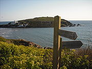
 The route is described here anticlockwise, from Minehead to Poole. The distance and total ascent between any two points, in either direction, can be obtained from The South West Coast Path Association Distance Reckoner. A survey carried out in 1999 and 2000 found that at that time the path had 2,473 signposts or waymarks, and included 302 bridges, 921 stile
s, and 26,719 steps. In practice, any such calculation is soon out of date because of path diversions due to landslips or access changes. Many walkers take about eight weeks to complete the path, often dividing this into sections walked over several years. In contrast, a team of six Royal Marines
, taking turns in pairs to run two-hour sections, completed the path in six days in 2004.
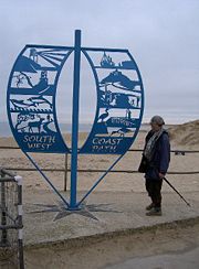
 The South West Coast Path starts from the western side of Minehead
, in Somerset
, at a marker erected in 2001 and partly paid for by the South West Coast Path Association
. The path follows the waterfront past the harbour to Culver Cliff before climbing up on a zigzag path through woodland. Entering the Exmoor National Park, it cuts inland past North Hill, Selworthy Beacon and Bossington Hill before regaining the cliff top at Hurlestone Point
. After passing through Bossington it follows the beach to Porlock Weir
and connects with the Coleridge Way
.
The scenery of rocky headlands, ravines, waterfalls and towering cliffs gained the Exmoor coast recognition as a Heritage Coast
in 1991. The Exmoor Coastal Heaths
have been recognised as a Site of Special Scientific Interest
due to the diversity of species present. The path passes the smallest parish church in England, Culbone Church
, in Culbone
. To the south of the path, the highest sea cliffs in England, reaching a height of 1350 feet (411 m), are at Culbone Hill, although this is more than a mile from the sea. The path crosses the county boundary into Devon
, a few hundred yards north of the National Park Centre at County Gate.
, after which the path comes to Lynmouth
with the Lynton and Lynmouth Cliff Railway
linking it with Lynton
on the hill above. At Lynmouth the path intersects with the Two Moors Way
. The river here suffered a catastrophic flood in the 1950s. Beyond Lynton the path passes through the Valley of the Rocks
, known for its herd of goats, then Duty Point and Lee Bay
, then Crock Point and Woody Bay
. After Highveer Rocks the path crosses the small River Heddon
then skirts Trentishoe Down and Holdstone Down and climbs Great Hangman
.
At 1043 feet (318 m) this is the highest point on the path. With a cliff face of 800 feet (244 m), it is described as the highest cliff on mainland Britain. The path now leaves the Exmoor National Park and enters the village of Combe Martin
, which claims to have the longest village street in England (two miles).
 After rounding Widmouth Head, the path passes 'The Coastguard Cottages' in Hele Bay
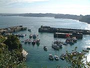
and enters the seaside resort
of Ilfracombe
, with its small harbour, surrounded by cliff
s. A seasonal foot passenger ferry
service runs from the harbour to Lundy Island
and The Balmoral, The Waverley
and pleasure boats ply to Porthcawl
near Swansea
. From Ilfracombe to Bideford
the Tarka Trail
coincides with the South West Coast Path.
 The path leaves Ilfracombe through The Torrs
and follows the cliff top past several small bays including Lee Bay
before passing Bull Point and the Bull Point Lighthouse
, into Rackham Bay. It then rounds Morte Point
, passing the nearby village of Mortehoe
before turning south to enter the long sandy Morte Bay which includes Woolacombe
and Putsborough
. Baggy Point
divides Morte Bay from Croyde Bay, and the surfing mecca of Croyde
and then the much larger Barnstaple or Bideford Bay, which forms part of the North Devon Coast Area of Outstanding Natural Beauty
. The wide expanse of Saunton Sands
, which takes its name from Saunton
, merges into the Braunton Burrows
Site of Special Scientific Interest
(SSSI), the largest sand dune system (psammosere
) in England
and a UNESCO Biosphere Reserve. It is particularly important ecologically because it includes the complete succession
al range of dune plant communities, with over 400 vascular plant
species. The short turf communities are very rich in lichen
s and herbs, and the dune slacks are also rich. The many rare plants and animals include 14 with UK Biodiversity Action Plan
s.
From Braunton Burrows the South West Coast Path turns inland following the Braunton Canal
to Braunton
and then along north bank of the River Taw
, following part of the route of the old Ilfracombe Branch Line
, past the perimeter of the Royal Marines Base Chivenor
towards Barnstaple
where the new Barnstaple Western Bypass
now forms the closest bridge over the Taw to the sea. After crossing medieval Barnstaple Long Bridge, the path then turns west following the disused Bideford & Instow Railway line along southern bank of the Taw past Fremington
Quay and the Fremington Quay Cliffs SSSI to Instow
at the joint estuary of the Rivers Taw and Torridge
and the Taw-Torridge Estuary (SSSI). The ferry which used to operate at Instow ceased on the retirement of the ferryman in 2007, so the path now goes upstream to cross the river by the 13th century bridge at Bideford
, which is the site of the Bideford Railway Heritage Centre and terminus of the North Devon Railway
.
The path continues north beside the Torridge Estuary, in places following the route of the Bideford, Westward Ho! and Appledore Railway
, past Northam
to Appledore and around the promontory past the Shell middens and a submerged forest, that dates from the Mesolithic
period, off the pebble ridge to Westward Ho!
(this is the only placename in the UK which includes an exclamation mark). The path then follows the coast around Clovelly Bay where several small villages including Abbotsham
lie inland, because of the cliffs. The path passes the site of the Iron Age
Hill fort
at Peppercombe Castle
and the village of Bucks Mills
. Clovelly
itself is a historic village with a small natural harbour. The path continues on to Hartland Point
, with its lighthouse
and radar tower, which marks the western limit (on the English side) of the Bristol Channel
with the Atlantic Ocean
to the west. There is a winter helicopter service from Hartland Point to the island of Lundy
, which is visible from many points along the path between Welcombe
and the Cornish border.
 The path crosses into Cornwall
at Marsland Mouth and continues south-westwards along this rocky coast, past Morwenstow
then Higher and Lower Sharpnose Points. Beyond Sandy Mouth, the walking becomes easier through Bude
, a popular surfing resort, and along Widemouth Bay
. Returning to the cliffs, the path continues on to Crackington Haven
, where the "High Cliff" at 735 feet (224 m) is Southern Britain's highest sheer-drop cliff, and from there to Boscastle
, the scene of flooding
in 2004.
Tintagel
and its castle
are associated with the conception of the legendary King Arthur
and a 15th century house that was later used as a post office
. The path continues to Trebarwith Strand
, Tregardock
, then to Port Gaverne
, Port Isaac
, and Port Quin
, three small harbours. Overlooking Port Quin is Doyden Castle, a 19th century folly.
 The scenery is now less wild, the cliffs less high. Rumps Point
has Iron Age
defences across its narrow neck but the path heads straight past to Pentire Head
then swings eastwards again into Polzeath
. The estuary of the River Camel
forces a detour away from the sea to Rock
and the Black Tor Ferry
that takes walkers into Padstow
.
From Stepper Point
the path again runs along low sea cliffs to Trevone
and Harlyn
Bay then around Trevose Head
. From here-—weather permitting-—the coast can be seen from Hartland in Devon to beyond St Ives in the west. The path runs southwards through Constantine Bay
to Porthcothan
then passes around Park Head to reach Mawgan Porth
.
 The long, sandy Watergate Bay
leads to St Columb Porth
and Newquay
. A rail link
with through trains to London
and the North of England on summer weekends has helped the town prosper as a seaside resort popular with surfers and clubbers. On the far side of the town, beyond Fistral Beach
, lies the River Gannel
. There are seasonal ferries to Crantock
and a footbridge which is passable at low tide, otherwise there is a detour inland to use the road bridge.
The path now skirts Pentire Point
West and then Kelsey Head to reach Holywell Bay
, another surfing beach. After passing round Penhale and crossing Penhale Sands the path enters Perranporth
, then climbs out the other side back onto a stretch of cliffs past Kligga Head to the village of St Agnes
. Past St Agnes Head, a breeding ground for kittiwake
s, lies the ruins of Towanroath Mine and the inlet at Chapel Porth. Next are the ruins of Wheal Charlotte mine and then Porthtowan
village.
After passing Nancekuke firing ranges, the path drops into Portreath
, once a busy port serving inland tin mines around Redruth
. Beyond lies Carvannel Downs with Samphire Island just off the coast, and then the Reskajeage Downs. Beyond the cove at Hell's Mouth, the path runs northwards to pass around Navax Point and Godrevy Point, offshore from which lies Godrevy Island
with its lighthouse
.
 Turning into the wide sweep of St Ives Bay
, where many walkers drop down onto the sands at low tide, the path follows the line of the sand dunes or Towans
as they are known here. This area was used for explosives manufacture for many years, the sand being ideal for absorbing any accidental explosions. The Towans are interrupted by two rivers, the small Red River
at the north end, and the larger River Hayle
and its estuary
towards the south. Although narrow, the estuary is tidal and fast flowing due to the large expanse of mud flats and docks that lie behind the Towans, so the path turns away from St Ives Bay to go round via Hayle
. The water is crossed using an old railway bridge and then the old Hayle Railway
is followed into the town centre then the A30 road
to Griggs Quay where quieter roads bring the Path around to the west side of the tidal mud flats. Views of the birdlife can be had from Carnsew Pool at Hayle and from the area around Lelant Saltings railway station
, although the official path is slightly inland on the A3074 road through Lelant
village, regaining the coast by crossing golf links to reach the last of the Towans above Porth Kidney Sands.
Rising back onto low cliffs, the path rounds Carrack Gladden
and enters Carbis Bay
, it then follows alongside the St Ives Bay railway line
into St Ives
; a bustling town favoured by artists since the 19th century, which is home to the Tate St Ives
art gallery and the Barbara Hepworth Museum
. The path passes the east-facing Portminster Beach and goes around "The Island", a headland, to the north-facing Portmeor Beach.
The coast now shows the open and ancient landscape of the Penwith
district along a series of wild headlands such as Clodgy Point, Hor Point, Pen Enys Point, and Carn Nuan Point. The Carracks
lie just offshore, locally known as Seal Island (and seals can often be seen close to the shore opposite here), then there lies Zennor
Head and Gurnard's Head
as the Path leads into Morvah
, although the village proper lies inland. Portheras Cove is a relief from the many small rocky bays along this coast but the cliffs then continue beyond the iconic, disused Botallack
Mine.
 From Cape Cornwall
at St Just
, the Path heads southwards to sandy Whitesand Bay and the village of Sennen
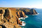
. At the end of the sands the path turns westwards one last time to reach Land's End
. This is the most westerly point
of the English mainland.
After passing Land's End the path continues further south past Pordenack Point and Mill Bay before turning fully eastward at Gwennap Head. Beyond the tiny village of Porthgwarra
lies St Levan
. The next bay lies below Porthcurno
. It is overlooked by the open-air Minack Theatre
and is where the Eastern Cable Company's cable came ashore, the first telegraph link with India
. Climbing out of the bay the path passes the precarious Logan Rock
.
The next village is Penberth
, then a series of bays are separated by the headlands of Merthen Point, Boscawen Point, and Tater Du with its lighthouse
built in 1965. Lamorna
Cove is a favourite with artists such as S. J. "Lamorna" Birch
, who lived there in a small cottage. Then, after rounding Carn Du, the path turns northwards towards Mousehole
and Penlee Point
. This section of the path follows a road into Newlyn
, but a diversion via Paul
allows walkers to follow a quieter inland path. Newlyn has a busy fishing harbour and is again favoured by artists, known as the Newlyn School
; it merges into Penzance
and the path now follows the promenade through the town, passing Penzance railway station
and continuing past the railway engine shed
along the shore of Mount's Bay with its views of St Michael's Mount
. This is an island at high tide but can be reached from Marazion
by a causeway at low tide.
The path now turns south again, passing the village of Perranuthnoe
(or Perran) and Perran Sands, then skirting inland across the neck of Cudden Point to Prussia Cove
and Bessy's Cove. A larger sandy beach is Praa Sands
after which the path climbs up onto a series of cliff tops such as Trewavas Head. This area shows many signs of Cornwall's mining history with abandoned engine houses such as Wheal Prosper close to the path.
After passing through Porthleven
the path crosses the shingle bank of Loe Bar with the freshwater Loe Pool behind. At Gunwalloe
more cliffs appear, leading to Poldhu
Cove overlooked by the radio station on Poldhu Point, then Porth Mellin on Mullion Cove
with Mullion Island offshore. Rounding Predannack Head, Vellan Head, and Rill Head (where the Spanish Armada
was first sighted on 29 July 1588), the path leads to Kynance Cove
and Lizard Point
, the lighthouse of which has been visible for some distance. Lizard Point is the most southerly point
of the British mainland.
 After passing The Lizard the path turns northwards, continuing past Housel Bay and a building used by Guglielmo Marconi
for radio experiments, then Bass Point with its Coastguard Station. The Lizard lifeboat station
is a sheltered position in Kilcobben Cove. Passing through Cadgwith
and across Kennack Sands, the path heads towards Black Head then into Coverack
. Once around Lowland Point, The Manacles
lie a mile offshore, a reef that has wrecked many ships. The path passes through Porthoustock
and Porthallow
, then around Nare Point lies Gillan Creek. This can be crossed at very low tide, but most walkers follow the lanes round the head of the creek to reach Dennis Head at the mouth of the Helford River
. To cross this wider river means following it inland to Helford
where there is a ferry across to Helford Passage
on the north bank. Some people take a short cut from Gillan Creek to Helford by a path through Manaccan
.
After following the river back through Durgan
to the open waters beyond Toll Point, the path skirts Falmouth Bay along Maenporth
, Swanpool and Gyllyngvase
beaches before passing around the headland beneath Pendennis Castle
to enter bustling Falmouth
. The castle was built, along with its twin at St Mawes
, to protect the deep water of Carrick Roads
from attack. This natural haven is what made Falmouth such an important harbour, it being the last good shelter for ships heading westwards towards the Atlantic Ocean
.
The path crosses the harbour on the St Mawes Ferry and then passes St Anthony Head
and Zone Point
and northwards past the village of Portscatho
and around Gerrans Bay. Beyond Nare Head is Portloe
in Veryan
Bay. The next big headland is Dodman Point
after which the coast path resumes its northwards course through Gorran Haven
and the fishing harbour at Mevagissey
to Pentewan
where the once busy dock has silted up with sand. The path then climbs up around Black Head to reach Portpean and then Charlestown
. This was the first harbour to serve the china clay industry around St Austell
and has featured in several films as it is home to a heritage fleet of sailing ships.
After passing Carlyon Bay
the path comes to the much busier china-clay exporting port of Par
, where it goes inland of the dock site. After passing through the village the path regains the coast at Par Sands and links with the Saints' Way
, a coast-to-coast path across Cornwall, at Polmear
. It then follows the cliff tops through Polkerris
and around Gribbin Head. From here to Polperro
is designated as a heritage coast.
 The path now passes Polridmouth and Readymoney Cove
to enter Fowey
('Foy'), another busy harbour but this time the deep water quays are situated up river above the town. The River Fowey
is crossed on the Polruan
ferry, beyond which are some steep cliffs with spectacular views. Beyond Lantic Bay lies Pencarrow Head then the larger Lantivet Bay with further cliffs and small coves leading to Polperro
, a fishing village which bans cars during the summer.
Beyond Polperro lies Talland Bay
and Portnadler Bay, with the bird reserve of Looe Island
(also known as St George's island) off shore. The path now enters Looe
, passing through Hannafore, West Looe then, after crossing the River Looe
on a seven-span bridge. The path continues up onto the cliff then heads towards Millendreath then along more cliffs to Seaton
, Downderry
, and Portwrinkle
.
The long beach of Whitsand Bay
has a fast-rising tide and is a military firing range so the path runs inland behind Tregantle Fort to reach Freathy
and Rame Head
. Beyond this lies Penlee Point
and then the path turns northwards into Plymouth Sound, skirting Cawsand
Bay and Mount Edgcumbe Country Park
to reach the ferry at Cremyll
. Beyond here lies the Hamoaze
, the combined estuary of the Tamar
and other rivers.
 The Cremyll Ferry
lands in Devon at Stonehouse
, one of the Three Towns
that make up the modern city of Plymouth
. The path follows roads past Stonehouse Barracks and Millbay
Docks to Plymouth Hoe
with its views across Plymouth Sound
. It then crosses Sutton Harbour by the Mayflower Steps then skirts the hill of Cattedown
to cross the River Plym
by the Laira Bridge to Plymstock
. Passing round the edge of the tidal Hooe Lake, the path regains the countryside above Jennycliff Bay, part of the Plymouth Sound, Shores and Cliffs
(Site of Special Scientific Interest
), and follows the cliffs past Bovisand
to Wembury
, Wembury Marine Centre
.
From Wembury the path travels east into the South Hams
district to the Warren Point Ferry, across the River Yealm
, near Newton Ferrers
. The River Erme
near Kingston
must be forded at Erme Mouth within one hour of low tide. The view to the southwest is then over Bigbury Bay
past Burgh Island
and Hope Cove
to the promontory known as Bolt Tail
. The next 6 miles (10 km) of cliff top paths from Bolberry Down
past Bolt Head
and the tidal ria
of Kingsbridge Estuary
to Prawle Point
, belong to the National Trust
. The estuary is crossed using the Salcombe Ferry, from Salcombe
to East Portlemouth
, close to Salcombe Castle
and within the South Devon Area of Outstanding Natural Beauty
(AONB). The path passes through the Prawle Point and Start Point Site of Special Scientific Interest
which is recognised as being an important site for solitary bees and wasps, the rare cuckoo bee
Nomada sexfasciata, and the Cirl bunting
.
 The path then continues around Lannacombe Bay to Start Point
and its Lighthouse
and then through Start Bay along a 3-mile (5 km) shingle causeway between Slapton Sands and the Slapton Ley
freshwater lake and nature reserve before entering the estuary of the River Dart
and historic port of Dartmouth
. From Dartmouth, the route uses either the Lower Ferry
or Passenger Ferry
to cross the river to Kingswear
.
Kingswear is the terminus of the Paignton and Dartmouth Steam Railway
which follows the River Dart
, but the coast path climbs out of the village in the opposite direction to reach Torbay
, known as "The English Riviera". It passes the historic harbour of Brixham
and the seaside towns of Goodrington
, Paignton
, Torquay
, Babbacombe
. The coast path then passes along wooded cliffs to reach Shaldon
and the River Teign
.
Crossing the river by ferry or the long Shaldon Bridge brings walkers to Teignmouth
, beyond which the coast path follows the South Devon Railway sea wall
to Hole Head where the Parson and Clerk rocks
look out to sea. Passing beneath the railway, the path climbs up to the main road, which it follows for a few yards before turning back towards the cliff top (in stormy weather the sea wall is too dangerous and this road must be followed most of the way from Teignmouth). Entering Dawlish
along a now by-passed toll road, the coast path descends back to the level of the railway which it follows to Dawlish Warren
, although a slightly more landward route is necessary at high tides.
Dawlish Warren is a sand spit
and nature reserve that lies at the mouth of the River Exe
. The route now turns away from the coast and follows the Exe estuary past Cockwood
to Starcross
where the seasonal Exmouth to Starcross Ferry
crosses to Exmouth
. The Exe Valley Way continues beyond Starcross towards Exeter, but when the ferry is not running it is possible to catch a train from either Dawlish Warren
or Starcross railway station
s to Exmouth railway station
.
On the eastern side of Exmouth, the coast path climbs up onto the High Land of Orcombe. This is the start of the Jurassic Coast
, a World Heritage Site
. The next town is Budleigh Salterton
, beyond which lies the River Otter
. The path then skirts Chiselbury Bay and Ladram Bay
towards Sidmouth
which sits at the mouth of the River Sid
. Access to the beach is via a wooden staircase known as Jacob's ladder. Sidmouth is surrounded by the East Devon
Area of Outstanding Natural Beauty
. Erosion remains a serious concern east of the mouth of the River Sid. The cliffs have been heavily eroded, threatening cliff top homes and the footpath, which passes along the tops of the cliff, around Lyme Bay
, avoiding The Undercliff
towards Branscombe
. The path then follows Seaton Bay past Beer
, with Beer Caves a man-made cave complex, resulting from the quarrying of Beer stone and Seaton
before going through The Undercliff SSSI
and NNR
and crossing the border into Dorset shortly before reaching Lyme Regis
.
 Across the Dorset
border, the Coast Path runs through the town of Lyme Regis
where the Cobb breakwater was seen in the film The French Lieutenant's Woman
and features on the film's poster. Further east, where it shares its route with the Monarch's Way
, the path passes by Golden Cap
, the highest point on the south coast, and on through Charmouth
and West Bay (near Bridport
), to Burton Bradstock
at the start of Chesil Beach
, an 18 miles (29 km) long tombolo
. At Abbotsbury
, the path leaves Chesil beach to follow the shores of the Fleet lagoon
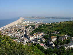
, until it reaches the terminus of Chesil beach next to the villages of Fortuneswell and Chiswell on the Isle of Portland
. The path circumnavigates the Isle of Portland, passing the lighthouses at Portland Bill
and the Weymouth and Portland National Sailing Academy
in Chiswell, and returns across Chesil beach to Wyke Regis
(encompassing the Rodwell Trail
) and along the shores of Portland Harbour
to the Nothe Fort
in the resort of Weymouth.
 In Weymouth the coast path runs along Weymouth Harbour and the Wey Estuary
up to Radipole Lake
, through the town centre to the Esplanade
on the shore of Weymouth Bay
, and on to Ringstead Bay
, with White Nothe
at its eastern end, near the village of Osmington Mills
. There is an alternative route around Weymouth and Portland
along the South Dorset Downs
, which reduces the footpath distance by 19.25 miles (31 km). Just the loop around the Isle of Portland can be omitted, reducing the journey by 13.2 miles (21.2 km).
The Coast path then follows the shores of the Isle of Purbeck
- past Bat's Head
and Swyre Head
, and on to Durdle Door
, a natural arch
which has been described as "one of Dorset's most recognisable features". This lies just to the west of the Lulworth Cove
, "the most visited geological locality in Britain". Further east lies the ghost village of Tyneham
, beside Worbarrow Bay
, and Kimmeridge
, next to Kimmeridge Bay, with its rocky shore and wave cut platform. Between Lulworth Cove and Kimmeridge the path passes through the Lulworth Military Range
, which is not always open to the public. When the ranges are in use a 12 miles (19 km) road detour is needed.
The coast path then reaches St Alban's Head
, just to the south of the village of Worth Matravers
. Between St Alban's Head and the resort of Swanage
is Durlston Country Park
nature reserve. North of Swanage is the chalk Ballard Down
, the eastern tip of which has been eroded
to form Old Harry Rocks
- a series of stack
s, arches and cave
s jutting into the sea between Swanage Bay and Studland Bay. This headland marks the end of the Jurassic Coast
World Heritage Site
. Behind Studland
beach, an extensive system of sand dune
s have formed a psammosere
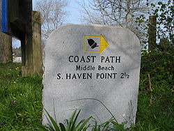
, stretching for miles across the Studland peninsula. The peninsula forms one shore of Poole Harbour
, one of the largest natural harbours in the world. Part of Studland beach is the National Trust's only official naturist beach. The South West Coast Path ends at South Haven Point, where there is a commemorative marker. The Sandbanks Ferry
links this to the Sandbanks
area of Poole
on the eastern edge of the harbour.
to Narva-Jõesuu
in Estonia
. The route crosses by ferry from Roscoff
to Plymouth, and beyond Poole the path follows the Bournemouth Coast Path
to Milford on Sea
, then the Solent Way
(with an Isle of Wight
option), South Downs Way
, 1066 Country Walk
and Saxon Shore Way
to Dover
, from where it returns to continental Europe.
The South West Coast Path, covering such a wide area, inevitably intersects with other, more local, routes, and it connects with many other long-distance paths offering opportunities for even longer expeditions:
, Exeter
, Newquay
, Penzance
and Plymouth
. From these places local trains or buses connect to many points of the path. Airports at Exeter
, Newquay
and Plymouth
are served from a range of national and international destinations.
Using public transport for at least part of their journey means that walkers can plan walks which start and finish at different places, rather than have to circle back to their start point to collect their cars.
Minehead
Minehead is a coastal town and civil parish in Somerset, England. It lies on the south bank of the Bristol Channel, north-west of the county town of Taunton, from the border with the county of Devon and in proximity of the Exmoor National Park...
in Somerset
Somerset
The ceremonial and non-metropolitan county of Somerset in South West England borders Bristol and Gloucestershire to the north, Wiltshire to the east, Dorset to the south-east, and Devon to the south-west. It is partly bounded to the north and west by the Bristol Channel and the estuary of the...
, along the coasts of Devon
Devon
Devon is a large county in southwestern England. The county is sometimes referred to as Devonshire, although the term is rarely used inside the county itself as the county has never been officially "shired", it often indicates a traditional or historical context.The county shares borders with...
and Cornwall
Cornwall
Cornwall is a unitary authority and ceremonial county of England, within the United Kingdom. It is bordered to the north and west by the Celtic Sea, to the south by the English Channel, and to the east by the county of Devon, over the River Tamar. Cornwall has a population of , and covers an area of...
, to Poole Harbour
Poole Harbour
Poole Harbour is a large natural harbour in Dorset, southern England, with the town of Poole on its shores. The harbour is a drowned valley formed at the end of the last ice age and is the estuary of several rivers, the largest being the Frome. The harbour has a long history of human settlement...
in Dorset
Dorset
Dorset , is a county in South West England on the English Channel coast. The county town is Dorchester which is situated in the south. The Hampshire towns of Bournemouth and Christchurch joined the county with the reorganisation of local government in 1974...
. Since it rises and falls with every river mouth, it is also one of the more challenging trails. The total height climbed has been calculated to be 114,931 ft (35,031 m), almost four times the height of Mount Everest
Mount Everest
Mount Everest is the world's highest mountain, with a peak at above sea level. It is located in the Mahalangur section of the Himalayas. The international boundary runs across the precise summit point...
.
The final section of the path was designated as a National Trail in 1978. Many of the landscapes which the South West Coast Path crosses have special status, either as a National Park
National park
A national park is a reserve of natural, semi-natural, or developed land that a sovereign state declares or owns. Although individual nations designate their own national parks differently A national park is a reserve of natural, semi-natural, or developed land that a sovereign state declares or...
or one of the Heritage Coast
Heritage Coast
A Heritage Coast is a strip of UK coastline designated by the Countryside Agency in England and the Countryside Council for Wales as having notable natural beauty or scientific significance.- Designated coastline :...
s. The path passes through two World Heritage Site
World Heritage Site
A UNESCO World Heritage Site is a place that is listed by the UNESCO as of special cultural or physical significance...
s: the Dorset and East Devon Coast, known as the Jurassic Coast
Jurassic Coast
The Jurassic Coast is a World Heritage Site on the English Channel coast of southern England. The site stretches from Orcombe Point near Exmouth in East Devon to Old Harry Rocks near Swanage in East Dorset, a distance of ....
, was designated in 2001, and the Cornwall and West Devon Mining Landscape
Cornwall and West Devon Mining Landscape
The Cornwall and West Devon Mining Landscape is a World Heritage Site which includes select mining landscapes across Cornwall and West Devon in the south west of the United Kingdom...
in 2007.
In the 1990s it was thought that the path brought £15 million into the area each year, but new research in 2003 indicated that it generated around £300 million a year in total, which could support more than 7,500 jobs. This research also recorded that 27.6% of visitors to the region came because of the Path, and they spent £136 million in a year. Local people took 23 million walks on the Path and spent a further £116 million, and other visitors contributed the remainder. A further study in 2005 estimated this figure to have risen to around £300 million.
History of the path
The path originated as a route for the CoastguardHer Majesty's Coastguard
Her Majesty's Coastguard is the service of the government of the United Kingdom concerned with co-ordinating air-sea rescue.HM Coastguard is a section of the Maritime and Coastguard Agency responsible for the initiation and co-ordination of all civilian maritime Search and Rescue within the UK...
to walk from lighthouse
Lighthouse
A lighthouse is a tower, building, or other type of structure designed to emit light from a system of lamps and lenses or, in older times, from a fire, and used as an aid to navigation for maritime pilots at sea or on inland waterways....
to lighthouse patrolling for smugglers. They needed to be able to look down into every bay and cove: as a result, the path closely hugs the coast providing excellent views but rarely the most direct path between two points. The South West Coast Path is no longer used by the Coastguard but it has been transformed from a practical defence system into a resource for recreational walkers. The path is covered by England's right-of-way laws, as amended by the Countryside and Rights of Way Act 2000
Countryside and Rights of Way Act 2000
The Countryside and Rights of Way Act 2000 is a UK Act of Parliament which came into force on 30 November 2000.As of September 2007, not all sections of the Countryside and Rights of Way Act have yet come into force...
, that keep historic foot paths open to the public even when they pass through private property. Sections of the path are maintained by the National Trust
National Trust for Places of Historic Interest or Natural Beauty
The National Trust for Places of Historic Interest or Natural Beauty, usually known as the National Trust, is a conservation organisation in England, Wales and Northern Ireland...
, which owns parts of the coast.
The path is a designated National Trail, largely funded by Natural England
Natural England
Natural England is the non-departmental public body of the UK government responsible for ensuring that England's natural environment, including its land, flora and fauna, freshwater and marine environments, geology and soils, are protected and improved...
. It was created in stages, with its final section, Somerset and North Devon, opening in 1978. It is maintained by a dedicated South West Coast Path Team.
The South West Coast Path Association
South West Coast Path Association
The South West Coast Path Association is a United Kingdom registered charity which exists to promote the interests of users of the South West Coast Path, the longest National Trail in Britain at 630 miles ....
, a registered charity, exists to support the interests of users of the path. The Association was formed in 1973 and since then it has campaigned for improvements to the path. Its services include accommodation guides and completion certificates.
Route description
Stile
A stile is a structure which provides people a passage through or over a fence or boundary via steps, ladders, or narrow gaps. Stiles are often built in rural areas or along footpaths to allow access to an adjacent field or area separated by a fence, wall or hedge...
s, and 26,719 steps. In practice, any such calculation is soon out of date because of path diversions due to landslips or access changes. Many walkers take about eight weeks to complete the path, often dividing this into sections walked over several years. In contrast, a team of six Royal Marines
Royal Marines
The Corps of Her Majesty's Royal Marines, commonly just referred to as the Royal Marines , are the marine corps and amphibious infantry of the United Kingdom and, along with the Royal Navy and Royal Fleet Auxiliary, form the Naval Service...
, taking turns in pairs to run two-hour sections, completed the path in six days in 2004.
Somerset
Minehead
Minehead is a coastal town and civil parish in Somerset, England. It lies on the south bank of the Bristol Channel, north-west of the county town of Taunton, from the border with the county of Devon and in proximity of the Exmoor National Park...
, in Somerset
Somerset
The ceremonial and non-metropolitan county of Somerset in South West England borders Bristol and Gloucestershire to the north, Wiltshire to the east, Dorset to the south-east, and Devon to the south-west. It is partly bounded to the north and west by the Bristol Channel and the estuary of the...
, at a marker erected in 2001 and partly paid for by the South West Coast Path Association
South West Coast Path Association
The South West Coast Path Association is a United Kingdom registered charity which exists to promote the interests of users of the South West Coast Path, the longest National Trail in Britain at 630 miles ....
. The path follows the waterfront past the harbour to Culver Cliff before climbing up on a zigzag path through woodland. Entering the Exmoor National Park, it cuts inland past North Hill, Selworthy Beacon and Bossington Hill before regaining the cliff top at Hurlestone Point
Hurlestone Point
Hurlstone point is a promontory of land between Porlock Weir and Minehead in the Exmoor National Park on the coast of Somerset, England.Hurlstone Point marks the boundary between Porlock Bay and Blue Anchor Bay in the Bristol Channel and is on the South West Coast Path...
. After passing through Bossington it follows the beach to Porlock Weir
Porlock Weir
Porlock Weir lies about 1.5 miles west of Porlock, Somerset, England and is a small settlement which has grown up around the harbour. It is a popular visitor attraction....
and connects with the Coleridge Way
Coleridge Way
The Coleridge Way is a footpath in Somerset, England.It was opened in April 2005, and follows the walks taken by poet Samuel Taylor Coleridge, to Porlock, starting from Coleridge Cottage at Nether Stowey, where he once lived.The footpath is waymarked...
.
The scenery of rocky headlands, ravines, waterfalls and towering cliffs gained the Exmoor coast recognition as a Heritage Coast
Heritage Coast
A Heritage Coast is a strip of UK coastline designated by the Countryside Agency in England and the Countryside Council for Wales as having notable natural beauty or scientific significance.- Designated coastline :...
in 1991. The Exmoor Coastal Heaths
Exmoor Coastal Heaths
Exmoor Coastal Heaths is a 1758.3 hectare biological Site of Special Scientific Interest in Devon and Somerset, notified in 1994....
have been recognised as a Site of Special Scientific Interest
Site of Special Scientific Interest
A Site of Special Scientific Interest is a conservation designation denoting a protected area in the United Kingdom. SSSIs are the basic building block of site-based nature conservation legislation and most other legal nature/geological conservation designations in Great Britain are based upon...
due to the diversity of species present. The path passes the smallest parish church in England, Culbone Church
Culbone Church
Culbone Church located in the village of Culbone in Somerset, England is said to be the smallest church in England.The church seats about 30 people, and the chancel is x , the nave...
, in Culbone
Culbone
Culbone is a hamlet consisting of little more than the parish church and a few houses, in the parish of Oare in the Exmoor National Park, Somerset, England. As there is no road access it is a two-mile walk from Porlock Weir, and some four miles from Porlock itself.The village is situated in a...
. To the south of the path, the highest sea cliffs in England, reaching a height of 1350 feet (411 m), are at Culbone Hill, although this is more than a mile from the sea. The path crosses the county boundary into Devon
Devon
Devon is a large county in southwestern England. The county is sometimes referred to as Devonshire, although the term is rarely used inside the county itself as the county has never been officially "shired", it often indicates a traditional or historical context.The county shares borders with...
, a few hundred yards north of the National Park Centre at County Gate.
North Devon
The next big headland is Foreland PointForeland Point
Foreland Point is a rocky headland in Devon near Lynmouth, and is the most northerly point along the Devon and Exmoor coast. The highest cliff is 89 metres above the High Tide, although the highest point of the entire headland is near Countisbury at 302 metres.There is a lighthouse on the Point...
, after which the path comes to Lynmouth
Lynmouth
Lynmouth is a village in Devon, England, on the north edge of Exmoor.The village straddles the confluence of the West Lyn and East Lyn rivers, in a gorge below Lynton, to which it is connected by the Lynton and Lynmouth Cliff Railway....
with the Lynton and Lynmouth Cliff Railway
Lynton and Lynmouth Cliff Railway
The Lynton and Lynmouth Cliff Railway is a water-powered funicular railway joining the twin towns of Lynton and Lynmouth on the rugged coast of North Devon.-Origins:...
linking it with Lynton
Lynton
Lynton is a small town in Devon, England. It lies on the northern edge of Exmoor and is located at the top of a gorge above Lynmouth, to which it is connected by the Lynton and Lynmouth Cliff Railway...
on the hill above. At Lynmouth the path intersects with the Two Moors Way
Two Moors Way
The Two Moors Way is a long-distance path that runs from Ivybridge in South Devon to Lynmouth on the coast of North Devon, crossing parts of both Dartmoor and Exmoor along the way...
. The river here suffered a catastrophic flood in the 1950s. Beyond Lynton the path passes through the Valley of the Rocks
Valley of the Rocks
The Valley of the Rocks or The Valley of Rocks is a dry valley that runs parallel to the coast in north Devon, England, about to the west of the village of Lynton...
, known for its herd of goats, then Duty Point and Lee Bay
Lee Bay
Lee Bay is a small village on the North Devon coast near Woolacombe.The village of Lee lies at the foot of what is known locally as the Fuchsia Valley, and consists of around 100 properties, mostly old in style. The village centre is about a quarter of a mile from the sea, and is linked to the area...
, then Crock Point and Woody Bay
Woody Bay
Three miles west of Lynton and eight east of Combe Martin on the North Devon coast of England, stoney-beached Woody Bay nestles among the steep cliffs of the rugged coast below the heights of Exmoor...
. After Highveer Rocks the path crosses the small River Heddon
River Heddon
The River Heddon is a river in Devon, in the south of England. Running along the western edges of Exmoor, the river reaches the North Devon coast at Heddon's Mouth...
then skirts Trentishoe Down and Holdstone Down and climbs Great Hangman
Hangman cliffs
Hangman cliffs are near Combe Martin on Devon's Exmoor coast.Great Hangman is high with a cliff face of . It is the highest sea cliff in England and the highest point on the South West Coast Path....
.
At 1043 feet (318 m) this is the highest point on the path. With a cliff face of 800 feet (244 m), it is described as the highest cliff on mainland Britain. The path now leaves the Exmoor National Park and enters the village of Combe Martin
Combe Martin
Combe Martin is a village and civil parish on the North Devon coast about east of Ilfracombe. It is a small seaside resort with a sheltered cove on the edge of the Exmoor National Park...
, which claims to have the longest village street in England (two miles).
Hele Bay
Hele Bay is a small village and beach just to the east of the town of Ilfracombe in North Devon, England. It is on the South West Coast Path....
and enters the seaside resort
Seaside resort
A seaside resort is a resort, or resort town, located on the coast. Where a beach is the primary focus for tourists, it may be called a beach resort.- Overview :...
of Ilfracombe
Ilfracombe
Ilfracombe is a seaside resort and civil parish on the North Devon coast, England with a small harbour, surrounded by cliffs.The parish stretches along the coast from 'The Coastguard Cottages' in Hele Bay toward the east and 4 miles along The Torrs to Lee Bay toward the west...
, with its small harbour, surrounded by cliff
Cliff
In geography and geology, a cliff is a significant vertical, or near vertical, rock exposure. Cliffs are formed as erosion landforms due to the processes of erosion and weathering that produce them. Cliffs are common on coasts, in mountainous areas, escarpments and along rivers. Cliffs are usually...
s. A seasonal foot passenger ferry
Ferry
A ferry is a form of transportation, usually a boat, but sometimes a ship, used to carry primarily passengers, and sometimes vehicles and cargo as well, across a body of water. Most ferries operate on regular, frequent, return services...
service runs from the harbour to Lundy Island
Lundy
Lundy is the largest island in the Bristol Channel, lying off the coast of Devon, England, approximately one third of the distance across the channel between England and Wales. It measures about at its widest. Lundy gives its name to a British sea area and is one of the islands of England.As of...
and The Balmoral, The Waverley
PS Waverley
PS Waverley is the last seagoing passenger carrying paddle steamer in the world. Built in 1946, she sailed from Craigendoran on the Firth of Clyde to Arrochar on Loch Long until 1973...
and pleasure boats ply to Porthcawl
Porthcawl
Porthcawl is a town on the south coast of Wales in the county borough of Bridgend, 25 miles west of the capital city, Cardiff and 19 miles southeast of Swansea...
near Swansea
Swansea
Swansea is a coastal city and county in Wales. Swansea is in the historic county boundaries of Glamorgan. Situated on the sandy South West Wales coast, the county area includes the Gower Peninsula and the Lliw uplands...
. From Ilfracombe to Bideford
Bideford
Bideford is a small port town on the estuary of the River Torridge in north Devon, south-west England. It is also the main town of the Torridge local government district.-History:...
the Tarka Trail
Tarka Trail
The Tarka Trail is a series of footpaths and cyclepaths around north Devon, England that follow the route taken by Tarka the Otter in the book of that name. It is a figure-of-eight route, based on Barnstaple, and covers some of path....
coincides with the South West Coast Path.
The Torrs
The Torrs are a Local Nature Reserve and one of the four main hills in the North Devon coastal town of Ilfracombe.The South West Coast Path passes through the Torrs....
and follows the cliff top past several small bays including Lee Bay
Lee Bay
Lee Bay is a small village on the North Devon coast near Woolacombe.The village of Lee lies at the foot of what is known locally as the Fuchsia Valley, and consists of around 100 properties, mostly old in style. The village centre is about a quarter of a mile from the sea, and is linked to the area...
before passing Bull Point and the Bull Point Lighthouse
Bull Point Lighthouse
Bull Point Lighthouse is a lighthouse on Bull Point, about one mile north of the village of Mortehoe, on the northern coast of Devon, England. The original lighthouse was constructed in 1879 after a group of local "clergy, ship-owners, merchants and landowners" appealed to Trinity House for one...
, into Rackham Bay. It then rounds Morte Point
Morte Point
Morte Point is a peninsula on the North West coast of Devon, England, belonging to the National Trust. To the east is the village of Mortehoe and to the south is the seaside resort of Woolacombe....
, passing the nearby village of Mortehoe
Mortehoe
thumb|right|250px|Mortehoe, Devon - the main street, looking southMortehoe is a village on the north coast of Devon near Woolacombe, sited on the hilly land behind Morte Point. A nearby village is Lee Bay....
before turning south to enter the long sandy Morte Bay which includes Woolacombe
Woolacombe
Woolacombe is a seaside resort on the coast of North Devon, England, which lies at the mouth of a valley . The beach, which has Blue Flag and Premier Seaside Beach awards for its cleanliness, water quality and facilities, is long, sandy, gently sloping and faces the Atlantic Ocean near the...
and Putsborough
Putsborough
Putsborough is a beach on the coast of North Devon, England, between Croyde and Woolacombe.Putsborough beach is situated on the southern end of Woolacombe Sands. The surf works at all tide stages but mid to high tend to have an edge. It is the only beach in the area that benefits from some...
. Baggy Point
Baggy Point
Baggy Point is a headland in north Devon, England. It separates Croyde bay and Morte Bay which includes the beaches of Woolacombe and Putsborough.The sandstone rocks are popular with climbers....
divides Morte Bay from Croyde Bay, and the surfing mecca of Croyde
Croyde
Croyde is a village on the west-facing coastline of North Devon, England. The village lies on the South West Coast Path near to Baggy Point, which is owned by the National Trust. It lies within the North Devon Coast Area of Outstanding Natural Beauty...
and then the much larger Barnstaple or Bideford Bay, which forms part of the North Devon Coast Area of Outstanding Natural Beauty
Area of Outstanding Natural Beauty
An Area of Outstanding Natural Beauty is an area of countryside considered to have significant landscape value in England, Wales or Northern Ireland, that has been specially designated by the Countryside Agency on behalf of the United Kingdom government; the Countryside Council for Wales on...
. The wide expanse of Saunton Sands
Saunton Sands
Saunton Sands on a wet and windy day|right|thumbSaunton Sands is a beach in the English village of Saunton on the North Devon coast near Braunton, popular as a longboard surfing location. Its southern end, 'Crow Point', lies at mouth of the River Taw estuary...
, which takes its name from Saunton
Saunton
Saunton is a village located approximately two miles from Braunton on the North Devon coast in the South West of England.Several kilometres long, the village borders the former national nature reserve, Braunton Burrows...
, merges into the Braunton Burrows
Braunton Burrows
Braunton Burrows is a sand dune system on the North Devon coast. Braunton Burrows is a prime British sand dune site, the largest sand dune system in England. It is particularly important ecologically because it includes the complete successional range of dune plant communities, with over 400...
Site of Special Scientific Interest
Site of Special Scientific Interest
A Site of Special Scientific Interest is a conservation designation denoting a protected area in the United Kingdom. SSSIs are the basic building block of site-based nature conservation legislation and most other legal nature/geological conservation designations in Great Britain are based upon...
(SSSI), the largest sand dune system (psammosere
Psammosere
A psammosere is a seral community, an ecological succession that began life on newly exposed coastal sand. Most common psammoseres are sand dune systems....
) in England
England
England is a country that is part of the United Kingdom. It shares land borders with Scotland to the north and Wales to the west; the Irish Sea is to the north west, the Celtic Sea to the south west, with the North Sea to the east and the English Channel to the south separating it from continental...
and a UNESCO Biosphere Reserve. It is particularly important ecologically because it includes the complete succession
Ecological succession
Ecological succession, is the phenomenon or process by which a community progressively transforms itself until a stable community is formed. It is a fundamental concept in ecology, and refers to more or less predictable and orderly changes in the composition or structure of an ecological community...
al range of dune plant communities, with over 400 vascular plant
Vascular plant
Vascular plants are those plants that have lignified tissues for conducting water, minerals, and photosynthetic products through the plant. Vascular plants include the clubmosses, Equisetum, ferns, gymnosperms and angiosperms...
species. The short turf communities are very rich in lichen
Lichen
Lichens are composite organisms consisting of a symbiotic organism composed of a fungus with a photosynthetic partner , usually either a green alga or cyanobacterium...
s and herbs, and the dune slacks are also rich. The many rare plants and animals include 14 with UK Biodiversity Action Plan
Biodiversity Action Plan
A Biodiversity Action Plan is an internationally recognized program addressing threatened species and habitats and is designed to protect and restore biological systems. The original impetus for these plans derives from the 1992 Convention on Biological Diversity...
s.
From Braunton Burrows the South West Coast Path turns inland following the Braunton Canal
Braunton Canal
The Braunton Canal is a cut made to straighten the course of the upper section of the River Caen, known as Braunton Pill, and to provide a new quay for the village of Braunton in North Devon, England...
to Braunton
Braunton
Braunton is situated west of Barnstaple, Devon, England and is claimed to be the largest village in England, with a population in 2001 of 7,510. It is home to the nearby Braunton Great Field and Braunton Burrows, a National Nature and UNESCO Biosphere Reserve....
and then along north bank of the River Taw
River Taw
The River Taw rises at Taw Head, a spring on the central northern flanks of Dartmoor. It reaches the Bristol Channel away on the north coast of Devon at a joint estuary mouth which it shares with the River Torridge.-Watercourse:...
, following part of the route of the old Ilfracombe Branch Line
Ilfracombe Branch Line
The Ilfracombe Branch of the London & South Western Railway , ran between Barnstaple and Ilfracombe in North Devon. The branch opened as a single-track line in 1874, but was sufficiently popular that it needed to be upgraded to double-track in 1889....
, past the perimeter of the Royal Marines Base Chivenor
Royal Marines Base Chivenor
Royal Marines Base Chivenor is a British military base used primarily by the Royal Marines. It is situated on the northern shore of the Taw estuary, adjacent to the South West Coast Path, on the north coast of Devon, England....
towards Barnstaple
Barnstaple
Barnstaple is a town and civil parish in the local government district of North Devon in the county of Devon, England, UK. It lies west southwest of Bristol, north of Plymouth and northwest of the county town of Exeter. The old spelling Barnstable is now obsolete.It is the main town of the...
where the new Barnstaple Western Bypass
Barnstaple Western Bypass
The Barnstaple Western Bypass is a congestion-relief scheme designed to take road traffic away from the town centre of Barnstaple, a market town in Devon, South West England...
now forms the closest bridge over the Taw to the sea. After crossing medieval Barnstaple Long Bridge, the path then turns west following the disused Bideford & Instow Railway line along southern bank of the Taw past Fremington
Fremington, Devon
Fremington is a village and civil parish in North Devon three miles west of Barnstaple. It was formerly a borough that sent members to Parliament in the reign of Edward III. The parish includes the neighbouring villages of Bickington and Yelland, the latter only asserting its identity as separate...
Quay and the Fremington Quay Cliffs SSSI to Instow
Instow
Instow is a village in north Devon, England. It is on the estuary where the rivers Taw and Torridge meet, between the villages of Westleigh and Yelland and on the opposite bank of Appledore....
at the joint estuary of the Rivers Taw and Torridge
River Torridge
The River Torridge is a river in Devon in England. It was the home of Tarka the Otter in Henry Williamson's book. The Torridge local government district is named after the river....
and the Taw-Torridge Estuary (SSSI). The ferry which used to operate at Instow ceased on the retirement of the ferryman in 2007, so the path now goes upstream to cross the river by the 13th century bridge at Bideford
Bideford
Bideford is a small port town on the estuary of the River Torridge in north Devon, south-west England. It is also the main town of the Torridge local government district.-History:...
, which is the site of the Bideford Railway Heritage Centre and terminus of the North Devon Railway
North Devon Railway
The North Devon Railway was a British railway company which operated a line from Cowley Bridge Junction, near Exeter, to Bideford in Devon, later becoming part of the London and South Western Railway's system...
.
The path continues north beside the Torridge Estuary, in places following the route of the Bideford, Westward Ho! and Appledore Railway
Bideford, Westward Ho! and Appledore Railway
The Bideford, Westward Ho! and Appledore Railway was most unusual amongst British railways in that although it was built as a standard gauge line, it was not joined to the rest of the railway network, despite the London and South Western Railway having a station at Bideford East-the-Water, just...
, past Northam
Northam, Devon
Northam is a small town in Devon, England, lying north of Bideford and south of Westward Ho!. It is thought to have been the site of an Anglo-Saxon castle, and is said to have been where Hubba the Dane attacked Devon and was repelled . A little over a mile away along the coast is a town called...
to Appledore and around the promontory past the Shell middens and a submerged forest, that dates from the Mesolithic
Mesolithic
The Mesolithic is an archaeological concept used to refer to certain groups of archaeological cultures defined as falling between the Paleolithic and the Neolithic....
period, off the pebble ridge to Westward Ho!
Westward Ho!
Westward Ho! is a seaside village near Bideford in Devon, England. The A39 road provides access from the towns of Barnstaple, Bideford and Bude...
(this is the only placename in the UK which includes an exclamation mark). The path then follows the coast around Clovelly Bay where several small villages including Abbotsham
Abbotsham
Abbotsham is a village in the English county of Devon. In 2001 its population was 434.-Amenities:Abbotsham has one Post Office and General Store. There is a primary school, a church and a pub. There is also a village hall. Private business include a pre-natal scanning clinic. One bus service serves...
lie inland, because of the cliffs. The path passes the site of the Iron Age
Iron Age
The Iron Age is the archaeological period generally occurring after the Bronze Age, marked by the prevalent use of iron. The early period of the age is characterized by the widespread use of iron or steel. The adoption of such material coincided with other changes in society, including differing...
Hill fort
Hill fort
A hill fort is a type of earthworks used as a fortified refuge or defended settlement, located to exploit a rise in elevation for defensive advantage. They are typically European and of the Bronze and Iron Ages. Some were used in the post-Roman period...
at Peppercombe Castle
Peppercombe Castle
Peppercombe Castle is an Iron Age Hill fort situated on cliffs to the East of Bucks Mills in North Devon. The remains of the fort are hard to define from maps and it may well be that much of the site has been lost to coastal erosion, but it would seem to have been at around 80 m above sea...
and the village of Bucks Mills
Bucks Mills
Bucks Mills is a small village within the parish of Woolfardisworthy on the north coast of Devon, England. The village is within the North Devon Coast Area of Outstanding Natural Beauty and on the South West Coast Path....
. Clovelly
Clovelly
Clovelly is a village in the Torridge district of Devon, England. It is a major tourist attraction, famous for its history and beauty, its extremely steep car-free cobbled main street, donkeys, and its location looking out over the Bristol Channel. Thick woods shelter it and render the climate so...
itself is a historic village with a small natural harbour. The path continues on to Hartland Point
Hartland Point
Hartland Point is a high rocky outcrop of land on the northwestern tip of the Devon coast in England. It is three miles north-west of the village of Hartland. The point marks the western limit of the Bristol Channel with the Atlantic Ocean continuing to the west...
, with its lighthouse
Hartland Point Lighthouse
Hartland Point Lighthouse is a Grade II listed building at Hartland Point, Devon, England. The point marks the western limit of the Bristol Channel with the Atlantic Ocean continuing to the west....
and radar tower, which marks the western limit (on the English side) of the Bristol Channel
Bristol Channel
The Bristol Channel is a major inlet in the island of Great Britain, separating South Wales from Devon and Somerset in South West England. It extends from the lower estuary of the River Severn to the North Atlantic Ocean...
with the Atlantic Ocean
Atlantic Ocean
The Atlantic Ocean is the second-largest of the world's oceanic divisions. With a total area of about , it covers approximately 20% of the Earth's surface and about 26% of its water surface area...
to the west. There is a winter helicopter service from Hartland Point to the island of Lundy
Lundy
Lundy is the largest island in the Bristol Channel, lying off the coast of Devon, England, approximately one third of the distance across the channel between England and Wales. It measures about at its widest. Lundy gives its name to a British sea area and is one of the islands of England.As of...
, which is visible from many points along the path between Welcombe
Welcombe
Welcombe is a village and civil parish on the coast of North Devon, England, just north of the border with Cornwall. It is part of the District of Torridge....
and the Cornish border.
North Cornwall
Cornwall
Cornwall is a unitary authority and ceremonial county of England, within the United Kingdom. It is bordered to the north and west by the Celtic Sea, to the south by the English Channel, and to the east by the county of Devon, over the River Tamar. Cornwall has a population of , and covers an area of...
at Marsland Mouth and continues south-westwards along this rocky coast, past Morwenstow
Morwenstow
thumb|Parish Church of St Morwenna and St John the Baptist, MorwenstowMorwenstow is a civil parish and hamlet in north Cornwall, United Kingdom. The hamlet is situated near the coast approximately six miles north of Bude....
then Higher and Lower Sharpnose Points. Beyond Sandy Mouth, the walking becomes easier through Bude
Bude
Bude is a small seaside resort town in North Cornwall, England, at the mouth of the River Neet . It lies just south of Flexbury, north of Widemouth Bay and west of Stratton and is located along the A3073 road off the A39. Bude is twinned with Ergué-Gabéric in Brittany, France...
, a popular surfing resort, and along Widemouth Bay
Widemouth Bay
Widemouth Bay is a bay and beach on the Atlantic coast of Cornwall, England, UK, approximately 3 miles south of Bude. This stretch of coast is steeped in the smuggling history of times before, and not far south of Widemouth Bay can be found many little inlets and coves.-Activities:The beach is...
. Returning to the cliffs, the path continues on to Crackington Haven
Crackington Haven
Crackington Haven is a coastal village in Cornwall, United Kingdom. It is located in the civil parish of St Gennys at at the head of a cove on the Atlantic coast. The village is seven miles south-southwest of Bude and four miles north-northeast of Boscastle.Middle Crackington and Higher...
, where the "High Cliff" at 735 feet (224 m) is Southern Britain's highest sheer-drop cliff, and from there to Boscastle
Boscastle
Boscastle is a village and fishing port on the north coast of Cornwall, England, in the civil parish of Forrabury and Minster. It is situated 14 miles south of Bude and 5 miles north-east of Tintagel....
, the scene of flooding
Boscastle flood of 2004
The Boscastle flood of 2004 occurred on Monday, 16 August 2004 in the two villages of Boscastle and Crackington Haven in Cornwall, England, United Kingdom. The villages suffered extensive damage after flash floods caused by an exceptional amount of rain that fell over eight hours that afternoon...
in 2004.
Tintagel
Tintagel
Tintagel is a civil parish and village situated on the Atlantic coast of Cornwall, United Kingdom. The population of the parish is 1,820 people, and the area of the parish is ....
and its castle
Tintagel Castle
Tintagel Castle is a medieval fortification located on the peninsula of Tintagel Island, adjacent to the village of Tintagel in Cornwall, United Kingdom. The site was possibly occupied in the Romano-British period, due to an array of artefacts dating to this period which have been found on the...
are associated with the conception of the legendary King Arthur
King Arthur
King Arthur is a legendary British leader of the late 5th and early 6th centuries, who, according to Medieval histories and romances, led the defence of Britain against Saxon invaders in the early 6th century. The details of Arthur's story are mainly composed of folklore and literary invention, and...
and a 15th century house that was later used as a post office
Post office
A post office is a facility forming part of a postal system for the posting, receipt, sorting, handling, transmission or delivery of mail.Post offices offer mail-related services such as post office boxes, postage and packaging supplies...
. The path continues to Trebarwith Strand
Trebarwith Strand
Trebarwith Strand , is a coastal settlement and section of coastline located on the north coast of Cornwall, United Kingdom, 2½ miles south of Tintagel...
, Tregardock
Tregardock
Tregardock is a coastal settlement and beach in north Cornwall, United Kingdom. It is situated between Trebarwith Strand and Port GaverneTregardock was the location of a World War II aerial bombing and gunnery range at Treligga aerodrome....
, then to Port Gaverne
Port Gaverne
Port Gaverne is a hamlet on the north coast of Cornwall, in England, about half a mile east of Port Isaac. Although recognised as an independent hamlet by the Cornish, many tourists consider it as part of the larger village of Port Isaac, partially due to the reason it is home to only four...
, Port Isaac
Port Isaac
Port Isaac is a small and picturesque fishing village on the Atlantic Coast of North Cornwall, United Kingdom. The nearest towns are Wadebridge and Camelford, both ten miles away in opposite directions. Port Gaverne, commonly mistaken to be part of Port Isaac, is a hamlet that has its own...
, and Port Quin
Port Quin
Port Quin is a small cove and hamlet between Port Isaac and Polzeath on the Atlantic coast in north Cornwall, England, UK.The hamlet and the coastline is mainly owned by the National Trust for Places of Historic Interest or Natural Beauty; the Trust rents out several of the stone cottages as...
, three small harbours. Overlooking Port Quin is Doyden Castle, a 19th century folly.
The Rumps
The Rumps is a twin-headland promontory at the north-east corner of Pentire Head in north Cornwall, United Kingdom.The promontory is formed from hard basaltic rock and projects north into the Atlantic Ocean. Its headlands lie east-to-west...
has Iron Age
Iron Age
The Iron Age is the archaeological period generally occurring after the Bronze Age, marked by the prevalent use of iron. The early period of the age is characterized by the widespread use of iron or steel. The adoption of such material coincided with other changes in society, including differing...
defences across its narrow neck but the path heads straight past to Pentire Head
Pentire Point
Pentire Head is a headland and peninsula on the Atlantic coast in North Cornwall, England, UK and is approx one mile square. The headland projects north-west with Pentire Point at its north-west corner and The Rumps promontory at its north-east corner....
then swings eastwards again into Polzeath
Polzeath
Polzeath is a small seaside resort in the civil parish of St Minver in Cornwall, United Kingdom. It is situated approximately six miles north of Wadebridge on the Atlantic coast....
. The estuary of the River Camel
River Camel
The River Camel is a river in Cornwall, UK. It rises on the edge of Bodmin Moor and together with its tributaries drains a considerable part of North Cornwall. The river issues into the Celtic Sea area of the Atlantic Ocean between Stepper Point and Pentire Point having covered a distance of...
forces a detour away from the sea to Rock
Rock, Cornwall
Rock is a coastal village in Cornwall, United Kingdom. It is situated opposite Padstow on the northeast bank of the River Camel estuary. The village is in the civil parish of St Minver Lowlands approximately four miles northwest of Wadebridge.-Geography:The main residential area is set back from...
and the Black Tor Ferry
Black Tor Ferry
The Black Tor Ferry, also known as the Padstow to Rock Ferry, is a passenger ferry which crosses the tidal River Camel in north Cornwall, United Kingdom. The ferry carries pedestrians and cyclists only .-History:...
that takes walkers into Padstow
Padstow
Padstow is a town, civil parish and fishing port on the north coast of Cornwall, England, United Kingdom. The town is situated on the west bank of the River Camel estuary approximately five miles northwest of Wadebridge, ten miles northwest of Bodmin and ten miles northeast of Newquay...
.
From Stepper Point
Stepper Point
Stepper Point is a headland on the Atlantic coast in north Cornwall, England, UK.Stepper Point and Pentire Point stand at either side of the mouth of the River Camel; Stepper to the south-west, Pentire to the north-east....
the path again runs along low sea cliffs to Trevone
Trevone
Trevone is a seaside village near Padstow in Cornwall, England, UK.One long road, surrounded by houses, village hall, WI meeting hall, village shop and with few roads branching off, leads down to the beach. Two or three houses are "bed and breakfast" guest houses. There is a surf shop and small...
and Harlyn
Harlyn
Harlyn is a small village on the north coast of Cornwall, United Kingdom. It is situated inland from Harlyn Bay three miles from Padstow and about one mile from St. Merryn....
Bay then around Trevose Head
Trevose Head
Trevose Head is a headland on the Atlantic coast of north Cornwall, United Kingdom. It is situated approximately west of Padstow. The South West Coast Path runs around the whole promontory and is within the Cornwall Area of Outstanding Natural Beauty and the Trevose Head Heritage Coast...
. From here-—weather permitting-—the coast can be seen from Hartland in Devon to beyond St Ives in the west. The path runs southwards through Constantine Bay
Constantine Bay
Constantine Bay is a village and beach on the Atlantic coast of north Cornwall, United Kingdom. It is situated approximately three miles west of Padstow and is in the parish of St Merryn. The beach is popular with surfers and has lifeguard patrols in the summer...
to Porthcothan
Porthcothan
Porthcothan is a coastal village in Cornwall, United Kingdom, situated between Newquay and Padstow. It is within the parish of St Eval. The beach is popular with tourists and surfers and is patrolled by lifeguards during the day in the summer; local surf schools sometimes use the beach for tuition...
then passes around Park Head to reach Mawgan Porth
Mawgan Porth
Mawgan Porth is a beach and small settlement in north Cornwall, England, United Kingdom. It is situated north of Watergate Bay approximately four miles north of Newquay, on the Atlantic Ocean coast....
.
Watergate Bay
Watergate Bay is a bay located two miles north of Newquay on the B3276 Newquay to Padstow road near the village of Tregurrian in Cornwall, United Kingdom. It faces the Atlantic Ocean....
leads to St Columb Porth
Porth, Cornwall
Porth is a sea-side village near Newquay in Cornwall, England, United Kingdom.Notable residents have included:* Sir Richard Tangye* Sir Basil Tangye, Bart. * Derek Tangye, author, grandson of Sir Richard...
and Newquay
Newquay
Newquay is a town, civil parish, seaside resort and fishing port in Cornwall, England. It is situated on the North Atlantic coast of Cornwall approximately west of Bodmin and north of Truro....
. A rail link
Atlantic Coast Line, Cornwall
The Atlantic Coast Line is a community railway line in Cornwall, United Kingdom. The line runs from the English Channel at Par, to the Atlantic Ocean at Newquay.-Route:The Atlantic Coast Line starts from Par station, in the village and port of Par...
with through trains to London
London
London is the capital city of :England and the :United Kingdom, the largest metropolitan area in the United Kingdom, and the largest urban zone in the European Union by most measures. Located on the River Thames, London has been a major settlement for two millennia, its history going back to its...
and the North of England on summer weekends has helped the town prosper as a seaside resort popular with surfers and clubbers. On the far side of the town, beyond Fistral Beach
Fistral Beach
Fistral Beach is in Fistral Bay on the north coast of Cornwall, England, United Kingdom. It is situated half-a-mile west of Newquay at ....
, lies the River Gannel
River Gannel
The River Gannel rises in the village of Indian Queens in central Cornwall, United Kingdom. It flows north and becomes a tidal estuary that divides the town of Newquay from the village of Crantock and joins the Celtic Sea...
. There are seasonal ferries to Crantock
Crantock
Crantock is a coastal civil parish and a village in Cornwall, England, United Kingdom. The village is approximately two miles southwest of Newquay....
and a footbridge which is passable at low tide, otherwise there is a detour inland to use the road bridge.
The path now skirts Pentire Point
Pentire Point
Pentire Head is a headland and peninsula on the Atlantic coast in North Cornwall, England, UK and is approx one mile square. The headland projects north-west with Pentire Point at its north-west corner and The Rumps promontory at its north-east corner....
West and then Kelsey Head to reach Holywell Bay
Holywell, Cornwall
Holywell is a coastal village in north Cornwall, United Kingdom. It is situated about three miles west-southwest of Newquay.Holywell beach adjoins the settlement to the northwest and Penhale Camp, an army training establishment regularly used by cadets, is half-a-mile to the southwest...
, another surfing beach. After passing round Penhale and crossing Penhale Sands the path enters Perranporth
Perranporth
Perranporth is a small seaside resort on the north coast of Cornwall, England, United Kingdom. It is southwest of Newquay and northwest of Truro. Perranporth and its long beach face the Atlantic Ocean....
, then climbs out the other side back onto a stretch of cliffs past Kligga Head to the village of St Agnes
St Agnes, Cornwall
St Agnes is a civil parish and a large village on the north coast of Cornwall, United Kingdom. The village is situated approximately five miles north of Redruth and ten miles southwest of Newquay....
. Past St Agnes Head, a breeding ground for kittiwake
Kittiwake
The kittiwakes are two closely related seabird species in the gull family Laridae, the Black-legged Kittiwake and the Red-legged Kittiwake . The epithets "Black-legged" and "Red-legged" are used to distinguish the two species in North America, but in Europe, where R...
s, lies the ruins of Towanroath Mine and the inlet at Chapel Porth. Next are the ruins of Wheal Charlotte mine and then Porthtowan
Porthtowan
Porthtowan is a small village in Cornwall, England, in the United Kingdom, and is a popular summer tourist destination which lies within the Cornwall and West Devon Mining Landscape, a World Heritage Site. Porthtowan lies on Cornwall's north Atlantic coast about west of St Agnes, north of...
village.
After passing Nancekuke firing ranges, the path drops into Portreath
Portreath
Portreath is a civil parish, village and fishing port on the north coast of Cornwall, United Kingdom. The village is situated approximately three miles northwest of Redruth....
, once a busy port serving inland tin mines around Redruth
Redruth
Redruth is a town and civil parish traditionally in the Penwith Hundred in Cornwall, United Kingdom. It has a population of 12,352. Redruth lies approximately at the junction of the A393 and A3047 roads, on the route of the old London to Land's End trunk road , and is approximately west of...
. Beyond lies Carvannel Downs with Samphire Island just off the coast, and then the Reskajeage Downs. Beyond the cove at Hell's Mouth, the path runs northwards to pass around Navax Point and Godrevy Point, offshore from which lies Godrevy Island
Godrevy
Godrevy is an area of west Cornwall, United Kingdom, found on the north coast within St. Ives Bay and is popular with both the surfing community and walkers. It is home also to some areas administered by the National Trust, and a lighthouse maintained by Trinity House.- Godrevy Head :The headland ...
with its lighthouse
Lighthouse
A lighthouse is a tower, building, or other type of structure designed to emit light from a system of lamps and lenses or, in older times, from a fire, and used as an aid to navigation for maritime pilots at sea or on inland waterways....
.
West Cornwall
St Ives Bay
St Ives Bay is a bay on the Atlantic coast of north-west Cornwall in the United Kingdom. It is in the form of a shallow crescent, some 4 miles or 6 km across, between St Ives in the west and Godrevy Head in the east....
, where many walkers drop down onto the sands at low tide, the path follows the line of the sand dunes or Towans
The Towans
The word 'towan' means 'sand dune' in Kernewek, the Cornish language and occurs in numerous placenames . However, The Towans usually refers to the three-mile stretch of coastal dunes which extends north east from the estuary of the River Hayle to Gwithian beach with a mid-point near Upton...
as they are known here. This area was used for explosives manufacture for many years, the sand being ideal for absorbing any accidental explosions. The Towans are interrupted by two rivers, the small Red River
Red River, Cornwall
The Red River is a small river in north-west Cornwall, UK which issues into St Ives Bay at Godrevy on Cornwall's Atlantic coast. The Red River is approx 8 miles long and gets its name from the mineral deposits associated with tin mining which formerly coloured its water red...
at the north end, and the larger River Hayle
River Hayle
The River Hayle is a small river in west Cornwall, UK which issues into St Ives Bay at Hayle on Cornwall's Atlantic coast.The River Hayle is approx 12 miles long and it rises south-west of Crowan village. Its course is west for approx 5 miles...
and its estuary
Hayle Estuary
The Hayle Estuary is an estuary in west Cornwall, United Kingdom.The estuary of the River Hayle consists of a main channel, with several other nearby tidal areas, including Lelant Saltings, Copperhouse Creek and Carnsew Pool ....
towards the south. Although narrow, the estuary is tidal and fast flowing due to the large expanse of mud flats and docks that lie behind the Towans, so the path turns away from St Ives Bay to go round via Hayle
Hayle
Hayle is a small town, civil parish and cargo port in west Cornwall, United Kingdom. It is situated at the mouth of the Hayle River and is approximately seven miles northeast of Penzance...
. The water is crossed using an old railway bridge and then the old Hayle Railway
Hayle Railway
The Hayle Railway was an early Cornish railway, built to standard gauge, and opened in 1837. The railway served the engineering works and copper quays at Hayle with the copper mines of Redruth and Camborne carrying ore to the port and coal to the mines, before the construction of the Saltash Bridge...
is followed into the town centre then the A30 road
A30 road
The 284 miles A30 road from London to Land's End, historically known as the Great South West Road used to provide the most direct route from London to the south west; more recently the M3 motorway and A303 road performs this function for much of the route and only parts of A30 now retain trunk...
to Griggs Quay where quieter roads bring the Path around to the west side of the tidal mud flats. Views of the birdlife can be had from Carnsew Pool at Hayle and from the area around Lelant Saltings railway station
Lelant Saltings railway station
Lelant Saltings railway station was opened on 27 May 1978 to provide a park and ride facility for visitors to St Ives. It is situated on the A3074 road close to the junction with the A30 near the foot of the hill up to Lelant village.-History:...
, although the official path is slightly inland on the A3074 road through Lelant
Lelant
Lelant is a village in west Cornwall, England, UK. It is on the west side of the River Hayle estuary about 2½ miles southeast of St Ives and one mile west of Hayle....
village, regaining the coast by crossing golf links to reach the last of the Towans above Porth Kidney Sands.
Rising back onto low cliffs, the path rounds Carrack Gladden
Carrack Gladden
Carrack Gladden is a coastal headland in St Ives Bay just north of the Hayle Estuary between Hayle and St Ives, Cornwall.The cliffs between Carrack Gladden headland and Hawks Point to the east are of metamorphosed Devonian slates and rise to 60 metres high....
and enters Carbis Bay
Carbis Bay
Carbis Bay is a village and seaside resort in Cornwall, United Kingdom. It lies one mile SE of St Ives on the west side of St Ives Bay on the Atlantic coast....
, it then follows alongside the St Ives Bay railway line
St Ives Bay Line
The St Ives Bay Line is a railway line from to in Cornwall, United Kingdom. It was opened in 1877, the last new broad gauge passenger railway to be constructed in the country...
into St Ives
St Ives, Cornwall
St Ives is a seaside town, civil parish and port in Cornwall, England, United Kingdom. The town lies north of Penzance and west of Camborne on the coast of the Celtic Sea. In former times it was commercially dependent on fishing. The decline in fishing, however, caused a shift in commercial...
; a bustling town favoured by artists since the 19th century, which is home to the Tate St Ives
Tate St Ives
Tate St Ives is an art gallery in St Ives, Cornwall, England, exhibiting work by modern British artists, including work of the St Ives School. The three storey building, designed by architects Evans and Shalev, lies on the site of an old gas works, overlooking Porthmeor Beach. It was opened in...
art gallery and the Barbara Hepworth Museum
Barbara Hepworth Museum
The Barbara Hepworth Museum and Sculpture Garden in St Ives, Cornwall preserves the 20th century sculptor Barbara Hepworth's studio and garden much as they were when she lived and worked there.-History:...
. The path passes the east-facing Portminster Beach and goes around "The Island", a headland, to the north-facing Portmeor Beach.
The coast now shows the open and ancient landscape of the Penwith
Penwith
Penwith was a local government district in Cornwall, England, United Kingdom, whose council was based in Penzance. The district covered all of the Penwith peninsula, the toe-like promontory of land at the western end of Cornwall and which included an area of land to the east that fell outside the...
district along a series of wild headlands such as Clodgy Point, Hor Point, Pen Enys Point, and Carn Nuan Point. The Carracks
The Carracks
The Carracks and Little Carracks are a group of small rocky inshore islands off the Atlantic north coast of west Cornwall, United Kingdom. The name comes from "carrek", the Cornish language word for 'rock'....
lie just offshore, locally known as Seal Island (and seals can often be seen close to the shore opposite here), then there lies Zennor
Zennor
Zennor is a village and civil parish in Cornwall in England. The parish includes the villages of Zennor, Boswednack and Porthmeor and the hamlet of Treen. It is located on the north coast, about north of Penzance. Alphabetically, the parish is the last in Britain—its name comes from the Cornish...
Head and Gurnard's Head
Gurnard's Head
Gurnard's Head is a prominent headland on the north coast of the Penwith peninsula in Cornwall, England, United Kingdom. It is near the hamlet of Treen in the parish of Zennor....
as the Path leads into Morvah
Morvah
Morvah is a civil parish and village on the Penwith peninsula in west Cornwall, United Kingdom. The village is situated approximately eight miles west-southwest of St Ives and 5½ miles north-west of Penzance....
, although the village proper lies inland. Portheras Cove is a relief from the many small rocky bays along this coast but the cliffs then continue beyond the iconic, disused Botallack
Botallack
The Botallack Mine is a former mine in Botallack in west Cornwall, United Kingdom.The village is in a former tin mining area situated between the town of St Just in Penwith and the village of Pendeen....
Mine.
Cape Cornwall
Cape Cornwall is a small headland in Cornwall, UK. It is four miles north of Land's End near the town of St Just. A cape is the point of land where two bodies of water meet and until the first Ordnance Survey, 200 years ago, it was thought that Cape Cornwall was the most westerly point in...
at St Just
St Just in Penwith
St Just is a town and civil parish in Cornwall, England, United Kingdom. The parish encompasses the town of St Just and the nearby settlements of Trewellard, Pendeen and Kelynack: it is bounded by the parishes of Morvah to the north-east, Sancreed and Madron to the east, St Buryan and Sennen to...
, the Path heads southwards to sandy Whitesand Bay and the village of Sennen
Sennen
Sennen is a coastal civil parish and a village in Cornwall, United Kingdom. Sennen village is situated approximately eight miles west-southwest of Penzance....
. At the end of the sands the path turns westwards one last time to reach Land's End
Land's End
Land's End is a headland and small settlement in west Cornwall, England, within the United Kingdom. It is located on the Penwith peninsula approximately eight miles west-southwest of Penzance....
. This is the most westerly point
Extreme points of the United Kingdom
This is a list of the extreme points of the United Kingdom: the points that are farther north, south, east or west than any other location. Traditionally the extent of the island of Great Britain has stretched "from Land's End to John o' Groats" .This article does not include references to the...
of the English mainland.
After passing Land's End the path continues further south past Pordenack Point and Mill Bay before turning fully eastward at Gwennap Head. Beyond the tiny village of Porthgwarra
Porthgwarra
Porthgwarra is a small coastal village in the civil parish of St Levan, Cornwall, UK situated between Land's End and Porthcurno. Access to the cove is via a minor road off the B3283 road at Polgigga and leads to the car park in the village. There is a public convenience, public telephone and small...
lies St Levan
St Levan
St Levan is a civil parish and village in Cornwall, United Kingdom. The village is situated approximately eight miles south west of Penzance....
. The next bay lies below Porthcurno
Porthcurno
Porthcurno is a small village in the parish of St. Levan located in a valley on the south coast of the county of Cornwall, England in the United Kingdom. It is approximately to the west of the market town of Penzance and about from Land's End, the most westerly point of the English mainland...
. It is overlooked by the open-air Minack Theatre
Minack Theatre
The Minack Theatre is an open-air theatre, constructed above a gully with a rocky granite outcrop jutting into the sea...
and is where the Eastern Cable Company's cable came ashore, the first telegraph link with India
India
India , officially the Republic of India , is a country in South Asia. It is the seventh-largest country by geographical area, the second-most populous country with over 1.2 billion people, and the most populous democracy in the world...
. Climbing out of the bay the path passes the precarious Logan Rock
Logan Rock
The Logan Rock near the village of Treen in Cornwall, England, UK, is an example of a logan or rocking stone. Although it weighs some 80 tons, it was dislodged in 1824 by a group of British seamen, intent on showing what the Navy could do...
.
The next village is Penberth
Penberth
Penberth is a coastal village and cove on the Penwith peninsula in Cornwall, United Kingdom. It is situated approximately seven miles southwest of Penzance.Penberth Cove is one of the last remaining traditional fishing coves in Cornwall...
, then a series of bays are separated by the headlands of Merthen Point, Boscawen Point, and Tater Du with its lighthouse
Tater Du Lighthouse
Tater Du Lighthouse is Cornwall's most recently built lighthouse. The construction of the lighthouse came out of the tragedy of losing a small Spanish coaster called the Juan Ferrer on the 23rd of October 1963, on the nearby Boscawen Point, the vessel capsized with the loss of 11 lives...
built in 1965. Lamorna
Lamorna
Lamorna is a fishing village and cove in west Cornwall, United Kingdom. It is situated on the Penwith peninsula approximately four miles south of Penzance.-Newlyn School of Art and the Lamorna Colony:...
Cove is a favourite with artists such as S. J. "Lamorna" Birch
Lamorna Birch
Samuel John "Lamorna" Birch, RA, RWS was an artist in oils and watercolours. At the suggestion of fellow artist Stanhope Forbes, Birch adopted the soubriquet "Lamorna" to distinguish himself from Lionel Birch, an artist who was also working in the area at that time.-Biography:Lamorna Birch was...
, who lived there in a small cottage. Then, after rounding Carn Du, the path turns northwards towards Mousehole
Mousehole
Mousehole is a village and fishing port in Cornwall, United Kingdom. It is situated approximately 2½ miles south of Penzance on the shore of Mount's Bay.The village is in the civil parish of Penzance...
and Penlee Point
Penlee Point, Mousehole
Penlee Point is a promontory near the Cornish coastal fishing village of Mousehole. It was the launching point of the Penlee lifeboat, which was lost in the disaster of 1981....
. This section of the path follows a road into Newlyn
Newlyn
Newlyn is a town and fishing port in southwest Cornwall, England, United Kingdom.Newlyn forms a conurbation with the neighbouring town of Penzance and is part of Penzance civil parish...
, but a diversion via Paul
Paul, Cornwall
Paul is a civil parish and village in Cornwall, United Kingdom. It is situated two miles south of Penzance and one mile south of Newlyn.The village of Paul is represented on Penzance Town Council...
allows walkers to follow a quieter inland path. Newlyn has a busy fishing harbour and is again favoured by artists, known as the Newlyn School
Newlyn School
The Newlyn School is a term used to describe an art colony of artists based in or near to Newlyn, a fishing village adjacent to Penzance, Cornwall, from the 1880s until the early 20th century. The establishment of the Newlyn School was reminiscent of the Barbizon School in France, where artists...
; it merges into Penzance
Penzance
Penzance is a town, civil parish, and port in Cornwall, England, in the United Kingdom. It is the most westerly major town in Cornwall and is approximately 75 miles west of Plymouth and 300 miles west-southwest of London...
and the path now follows the promenade through the town, passing Penzance railway station
Penzance railway station
Penzance railway station serves the town of Penzance, Cornwall, UK. The station is the western terminus of the Cornish Main Line from London Paddington station. The current journey time to or from London is about five hours....
and continuing past the railway engine shed
Penzance TMD
Penzance TMD, also known as Long Rock TMD, is a railway Traction Maintenance Depot situated in the village of Long Rock east of Penzance, Cornwall, United Kingdom, and is the most westerly and southerly rail depot in the country. The depot operator is First Great Western...
along the shore of Mount's Bay with its views of St Michael's Mount
St Michael's Mount
St Michael's Mount is a tidal island located off the Mount's Bay coast of Cornwall, United Kingdom. It is a civil parish and is united with the town of Marazion by a man-made causeway of granite setts, passable between mid-tide and low water....
. This is an island at high tide but can be reached from Marazion
Marazion
Marazion is a civil parish and town in Cornwall, United Kingdom. It is situated on the shore of Mount's Bay, two miles east of Penzance and one mile east of Long Rock.St Michael's Mount is half-a-mile offshore from Marazion...
by a causeway at low tide.
The path now turns south again, passing the village of Perranuthnoe
Perranuthnoe
Perranuthnoe is a civil parish and a village in southwest Cornwall, United Kingdom. The village is situated on the east side of Mount's Bay approximately one mile east of Marazion and four miles east of Penzance....
(or Perran) and Perran Sands, then skirting inland across the neck of Cudden Point to Prussia Cove
Prussia Cove
Prussia Cove , formerly called the King's Cove, is a small private estate on the coast of Mount's Bay and to the east of Cudden Point, west Cornwall, UK. Part of the area is designated as a Site of Special Scientific Interest , a Geological Conservation Review site and is in an Area of Outstanding...
and Bessy's Cove. A larger sandy beach is Praa Sands
Praa Sands
Praa Sands is a coastal village in the Parish of Breage, located off the main road between Helston and Penzance in Cornwall, England, UK...
after which the path climbs up onto a series of cliff tops such as Trewavas Head. This area shows many signs of Cornwall's mining history with abandoned engine houses such as Wheal Prosper close to the path.
After passing through Porthleven
Porthleven
Porthleven is a town, civil parish and fishing port in Cornwall, United Kingdom, near Helston. It is the most southerly port on the island of Great Britain and was originally developed as a harbour of refuge, when this part of the Cornish coastline was recognised as a black spot for wrecks in days...
the path crosses the shingle bank of Loe Bar with the freshwater Loe Pool behind. At Gunwalloe
Gunwalloe
Gunwalloe is a coastal civil parish and a village in Cornwall, United Kingdom. It is situated on the Lizard Peninsula three miles south of Helston and partly contains The Loe, the largest natural freshwater lake in Cornwall.-History:...
more cliffs appear, leading to Poldhu
Poldhu
Poldhu is a small area in south Cornwall, England, UK, situated on the Lizard Peninsula; it comprises Poldhu Point and Poldhu Cove. It lies on the coast west of Goonhilly Downs, with Mullion to the south and Porthleven to the north...
Cove overlooked by the radio station on Poldhu Point, then Porth Mellin on Mullion Cove
Mullion, Cornwall
Mullion is a civil parish and village in Cornwall, United Kingdom. It is situated on the Lizard Peninsula approximately five miles south of Helston....
with Mullion Island offshore. Rounding Predannack Head, Vellan Head, and Rill Head (where the Spanish Armada
Spanish Armada
This article refers to the Battle of Gravelines, for the modern navy of Spain, see Spanish NavyThe Spanish Armada was the Spanish fleet that sailed against England under the command of the Duke of Medina Sidonia in 1588, with the intention of overthrowing Elizabeth I of England to stop English...
was first sighted on 29 July 1588), the path leads to Kynance Cove
Kynance Cove
Kynance Cove is a cove in southwest Cornwall, United Kingdom. It is situated on the Lizard peninsula approximately two miles north of Lizard Point...
and Lizard Point
Lizard Point, Cornwall
Lizard Point in Cornwall is at the southern tip of the Lizard Peninsula. It is situated half-a-mile south of Lizard village in the civil parish of Landewednack and approximately 11 miles southeast of Helston....
, the lighthouse of which has been visible for some distance. Lizard Point is the most southerly point
Extreme points of the United Kingdom
This is a list of the extreme points of the United Kingdom: the points that are farther north, south, east or west than any other location. Traditionally the extent of the island of Great Britain has stretched "from Land's End to John o' Groats" .This article does not include references to the...
of the British mainland.
South Cornwall
Guglielmo Marconi
Guglielmo Marconi was an Italian inventor, known as the father of long distance radio transmission and for his development of Marconi's law and a radio telegraph system. Marconi is often credited as the inventor of radio, and indeed he shared the 1909 Nobel Prize in Physics with Karl Ferdinand...
for radio experiments, then Bass Point with its Coastguard Station. The Lizard lifeboat station
The Lizard lifeboat station
The Lizard Lifeboat Station is a lifeboat station operated by the Royal National Lifeboat Institution . It is located at Kilcobben Cove on The Lizard peninsula in Cornwall, United Kingdom...
is a sheltered position in Kilcobben Cove. Passing through Cadgwith
Cadgwith
Cadgwith is a village and fishing port in Cornwall, United Kingdom. It is situated on the Lizard Peninsula between The Lizard and Coverack.-History:...
and across Kennack Sands, the path heads towards Black Head then into Coverack
Coverack
Coverack is a coastal village and fishing port in Cornwall, England, UK. It is situated on the east side of the Lizard peninsula approximately nine miles south of Falmouth....
. Once around Lowland Point, The Manacles
The Manacles
The Manacles are a set of treacherous rocks off The Lizard peninsula in Cornwall close to Porthoustock, which is a popular spot for diving due to the shipwrecks around them. The name derives from the Cornish for 'church stone', the top of St Keverne church being visible from the area.The rocks...
lie a mile offshore, a reef that has wrecked many ships. The path passes through Porthoustock
Porthoustock
Porthoustock is a hamlet near St Keverne in Cornwall, United Kingdom, on the east coast of Lizard Peninsula. Aggregates are quarried nearby and Porthoustock beach is dominated by a large concrete stone mill. The mill was once used to crush stone but is now disused. Container ships of up to 82m can...
and Porthallow
Porthallow
Porthallow is a small fishing village on the east coast of the The Lizard peninsula just south of the Helford River, in Cornwall, England, United Kingdom. Historically the village had a pilchard industry. It has one road running through it, with a pub, the Five Pilchards, and a post office. It is...
, then around Nare Point lies Gillan Creek. This can be crossed at very low tide, but most walkers follow the lanes round the head of the creek to reach Dennis Head at the mouth of the Helford River
Helford River
The Helford River is a ria located in Cornwall, England, UK, and not a true river. It is fed by a number of small streams into its numerous creeks...
. To cross this wider river means following it inland to Helford
Helford
Helford is a village in Cornwall, United Kingdom. It is situated on the south bank of the Helford River and is approximately five miles south-southwest of Falmouth.Helford is in the civil parish of Manaccan...
where there is a ferry across to Helford Passage
Helford Passage
Helford Passage is a village in Cornwall, United Kingdom. It is situated on the north bank of the Helford River opposite Helford approximately five miles south-southwest of Falmouth....
on the north bank. Some people take a short cut from Gillan Creek to Helford by a path through Manaccan
Manaccan
Manaccan is a civil parish and village on the Lizard peninsula in south Cornwall, England, United Kingdom. The village is situated approximately five miles south-southwest of Falmouth....
.
After following the river back through Durgan
Durgan
Durgan is a hamlet in the parish of Mawnan, south Cornwall, United Kingdom. It is situated beside the Helford River four miles south of Falmouth.Glendurgan Garden, a National Trust property is located in Durgan....
to the open waters beyond Toll Point, the path skirts Falmouth Bay along Maenporth
Maenporth
Maenporth is a cove and beach in west Cornwall, United Kingdom. It is situated approximately two miles south-southwest of Falmouth on the estuary of the River Fal....
, Swanpool and Gyllyngvase
Gyllyngvase
Gyllyngvase is one of the four beaches associated with Falmouth, Cornwall, United Kingdom, south of Pendennis Castle.It is to the south of Falmouth town centre, but was an essentially rural area as recently as the late 19th century...
beaches before passing around the headland beneath Pendennis Castle
Pendennis Castle
Pendennis Castle is a Henrician castle, also known as one of Henry VIII's Device Forts, in the English county of Cornwall. It was built in 1539 for King Henry VIII to guard the entrance to the River Fal on its west bank, near Falmouth. St Mawes Castle is its opposite number on the east bank and...
to enter bustling Falmouth
Falmouth, Cornwall
Falmouth is a town, civil parish and port on the River Fal on the south coast of Cornwall, England, United Kingdom. It has a total resident population of 21,635.Falmouth is the terminus of the A39, which begins some 200 miles away in Bath, Somerset....
. The castle was built, along with its twin at St Mawes
St Mawes
St Mawes is a small town opposite Falmouth, on the Roseland Peninsula on the south coast of Cornwall, England, United Kingdom. It lies on the east bank of the Carrick Roads, a large waterway created after the Ice Age from an ancient valley which flooded as the melt waters caused the sea level to...
, to protect the deep water of Carrick Roads
Carrick Roads
Carrick Roads is located on the southern Cornish coast in the UK, near Falmouth. It is a large waterway created after the Ice age from an ancient valley which flooded as the melt waters caused the sea level to rise dramatically , creating a large natural harbour which is navigable from Falmouth to...
from attack. This natural haven is what made Falmouth such an important harbour, it being the last good shelter for ships heading westwards towards the Atlantic Ocean
Atlantic Ocean
The Atlantic Ocean is the second-largest of the world's oceanic divisions. With a total area of about , it covers approximately 20% of the Earth's surface and about 26% of its water surface area...
.
The path crosses the harbour on the St Mawes Ferry and then passes St Anthony Head
St Anthony Head
St Anthony Head is a National Trust property situated at the southernmost tip of the Roseland Peninsula, Cornwall, England, United Kingdom, overlooking the entrance to one of the world's largest natural harbours: Carrick Roads and the estuary of River Fal...
and Zone Point
Zone Point
Zone Point is the southernmost extremity of the Roseland peninsula extending into Falmouth Bay near St Mawes in Cornwall, United Kingdom at .It is approximately 500 metres eastsoutheast of the St. Anthony's Lighthouse on St Anthony Head...
and northwards past the village of Portscatho
Portscatho
Portscatho is a coastal village on the Roseland Peninsula in Cornwall, United Kingdom. The village adjoins Gerrans on the east side of the peninsula approximately seven miles south-southeast of Truro....
and around Gerrans Bay. Beyond Nare Head is Portloe
Portloe
Portloe is a small village in Cornwall, United Kingdom situated on the Roseland Peninsula east of Veryan. Portloe currently harbours two full time working fishing vessels, the Jasmine and Katy Lil, both of which fish for crab and lobster in Veryan and Gerrans Bay, along with a fleet of smaller...
in Veryan
Veryan
Veryan is a coastal civil parish and a village on the Roseland Peninsula in Cornwall, United Kingdom. The main settlements are at Veryan Churchtown, Veryan Green, Portloe and the smaller hamlets of Trewartha, Treviskey, Carne and Camels...
Bay. The next big headland is Dodman Point
Dodman Point
Dodman Point is a high headland near Mevagissey, Cornwall. It was once an Iron Age promontory fort. At its seaward end is a large granite cross, erected to help protect shipping from this headland...
after which the coast path resumes its northwards course through Gorran Haven
Gorran Haven
Gorran Haven is a fishing village on the south coast of Cornwall, United Kingdom. It is situated approximately south of Mevagissey.The village lies in a cove between two sandy beaches...
and the fishing harbour at Mevagissey
Mevagissey
Mevagissey is a village, fishing port and civil parish in Cornwall, United Kingdom. The village is situated approximately five miles south of St Austell....
to Pentewan
Pentewan
Pentewan is a coastal village and former port in south Cornwall, United Kingdom. It is situated at three miles south of St Austell at the mouth of the St Austell River....
where the once busy dock has silted up with sand. The path then climbs up around Black Head to reach Portpean and then Charlestown
Charlestown, Cornwall
Charlestown is a village and port on the south coast of Cornwall, United Kingdom, in the parish of St Austell Bay. It is situated approximately south east of St Austell town centre....
. This was the first harbour to serve the china clay industry around St Austell
St Austell
St Austell is a civil parish and a major town in Cornwall, England, United Kingdom. It is situated on the south coast approximately ten miles south of Bodmin and 30 miles west of the border with Devon at Saltash...
and has featured in several films as it is home to a heritage fleet of sailing ships.
After passing Carlyon Bay
Carlyon Bay
For the parish council see CarlyonCarlyon Bay is a bay and beach in St Austell on the south coast of Cornwall, United Kingdom. It is located approximately east of the town centre.Carlyon Bay was formerly the location of the Cornwall Coliseum...
the path comes to the much busier china-clay exporting port of Par
Par, Cornwall
Par is a town and fishing port with a harbour on the south coast of Cornwall, England, United Kingdom. The town is situated in the civil parish of Tywardreath and Par and is approximately east of St Austell. Par has a population of around 1,400.....
, where it goes inland of the dock site. After passing through the village the path regains the coast at Par Sands and links with the Saints' Way
Saints' Way
The Saints' Way is a long-distance footpath in Cornwall, in the United Kingdom.The footpath runs from Padstow in the north to Fowey in the south, a distance of 26 miles . The path is well marked and guide books are available....
, a coast-to-coast path across Cornwall, at Polmear
Polmear, Cornwall
Polmear is a hamlet in Cornwall, England, UK. It is located on the A3082 road close to Par Sands and the village of Par, but forms part of the civil parish of Fowey. The centre of Fowey is some distant, whilst Par railway station is less than away...
. It then follows the cliff tops through Polkerris
Polkerris
Polkerris is a small village on the south coast of Cornwall, United Kingdom. It forms part of the civil parish of Fowey.The village was formerly part of the Rashleigh estate which is commemorated in the name of the pub, 'Rashleigh Inn'...
and around Gribbin Head. From here to Polperro
Polperro
Polperro is a village and fishing harbour on the south-east Cornwall coast in South West England, UK, within the civil parish of Lansallos. Situated on the River Pol, 4 miles west of the neighbouring town of Looe and west of the major city and naval port of Plymouth, it is well-known for...
is designated as a heritage coast.
Readymoney Cove
Readymoney Cove is a sandy beach to the south of the harbour town of Fowey, Cornwall, England, United Kingdom. It is sheltered by cliffs close to the mouth of the River Fowey Estuary and bounded, on one side, by the medieval part of the town of Fowey and, on the other, by St Catherine's Castle....
to enter Fowey
Fowey
Fowey is a small town, civil parish and cargo port at the mouth of the River Fowey in south Cornwall, United Kingdom. According to the 2001 census it had a population of 2,273.-Early history:...
('Foy'), another busy harbour but this time the deep water quays are situated up river above the town. The River Fowey
River Fowey
The River Fowey is a river in Cornwall, United Kingdom.It rises about north-west of Brown Willy on Bodmin Moor, passes Lanhydrock House, Restormel Castle and Lostwithiel, then broadens at Milltown before joining the English Channel at Fowey. It is only navigable by larger craft for the last ....
is crossed on the Polruan
Polruan
Polruan is a small fishing village in the parish of Lanteglos-by-Fowey in Cornwall, England, UK. It is bounded on three sides by water: to the north by Pont Creek, to the west by the River Fowey and to the south by the English Channel and neighbours village Bodinnick to the north, connected by a 4...
ferry, beyond which are some steep cliffs with spectacular views. Beyond Lantic Bay lies Pencarrow Head then the larger Lantivet Bay with further cliffs and small coves leading to Polperro
Polperro
Polperro is a village and fishing harbour on the south-east Cornwall coast in South West England, UK, within the civil parish of Lansallos. Situated on the River Pol, 4 miles west of the neighbouring town of Looe and west of the major city and naval port of Plymouth, it is well-known for...
, a fishing village which bans cars during the summer.
Beyond Polperro lies Talland Bay
Talland Bay
Talland Bay is west of the town of Looe in Cornwall. On Talland Bay are two sheltered shingle beaches, Talland Sand and Rotterdam Beach, and the bay was well known in previous centuries as a landing spot for smugglers. It has also been the scene of many shipwrecks including that of a French...
and Portnadler Bay, with the bird reserve of Looe Island
Looe Island
Looe Island, also known as St George's Island, and historically St Michael's Island is a small island a mile from the mainland town of Looe in Cornwall, United Kingdom....
(also known as St George's island) off shore. The path now enters Looe
Looe
Looe is a small coastal town, fishing port and civil parish in the former Caradon district of south-east Cornwall, England, with a population of 5,280 . Looe is divided in two by the River Looe, East Looe and West Looe being connected by a bridge...
, passing through Hannafore, West Looe then, after crossing the River Looe
River Looe
The River Looe is a river in south-east Cornwall, which flows into the English Channel at Looe. It has two main branches, the East Looe River and the West Looe River....
on a seven-span bridge. The path continues up onto the cliff then heads towards Millendreath then along more cliffs to Seaton
Seaton, Cornwall
Seaton is a village on the south coast of Cornwall, United Kingdom. It is situated at the mouth of the River Seaton approximately three miles east of Looe and ten miles west of Plymouth. The village is in the civil parish of Deviock....
, Downderry
Downderry
Downderry is a coastal village in southeast Cornwall, United Kingdom. It is situated 18 miles west of Plymouth and one mile east of Seaton.Downderry has a long beach of light shingle. Dogs are allowed on the beach...
, and Portwrinkle
Portwrinkle
Portwrinkle is a small coastal village in south-east Cornwall, United Kingdom. It is situated at the western end of Whitsand Bay five miles south-west of Saltash....
.
The long beach of Whitsand Bay
Whitsand Bay
Whitsand Bay, situated in south east Cornwall, England, United Kingdom runs from Rame Head in the east to Portwrinkle in the west. It is characterised by sheer, high cliffs, dramatic scenery and long stretches of sandy beaches...
has a fast-rising tide and is a military firing range so the path runs inland behind Tregantle Fort to reach Freathy
Freathy
Freathy is a beach and coastal settlement on the Rame Peninsula in east Cornwall, England, United Kingdom.Freathy is accessible by the coast road along which runs the South West Coast Path...
and Rame Head
Rame Head
Rame Head is a coastal headland, southwest of the village of Rame in southeast Cornwall, United Kingdom.-History and antiquities:The site was used for a hill fort in the Iron Age. The headland has a prominent chapel, dedicated to St Michael, accessible by a steep footpath...
. Beyond this lies Penlee Point
Penlee Point, Rame
Penlee Point is a coastal headland to the southeast of the village of Rame in southeast Cornwall, England, UK. The point lies at the entrance to Plymouth Sound.-Historical locations:...
and then the path turns northwards into Plymouth Sound, skirting Cawsand
Cawsand
Cawsand and Kingsand are twin villages in southeast Cornwall, United Kingdom. The village is situated on the Rame Peninsula and is in the parish of Maker-with-Rame....
Bay and Mount Edgcumbe Country Park
Mount Edgcumbe Country Park
Mount Edgcumbe Country Park is one of four designated Country Parks in Cornwall. It is situated on the Rame Peninsula, overlooking Plymouth Sound and the River Tamar....
to reach the ferry at Cremyll
Cremyll
Cremyll is a coastal village in south-east Cornwall, United Kingdom. It is situated approximately one mile west of Plymouth.Cremyll is on the Rame Peninsula facing Plymouth Sound. The Cremyll Ferry carries foot passengers and cyclists from Cremyll to Plymouth...
. Beyond here lies the Hamoaze
Hamoaze
The Hamoaze is an estuarine stretch of the tidal River Tamar, between the River Lynher and Plymouth Sound, England.The Hamoaze flows past Devonport Dockyard, which belongs to the Royal Navy...
, the combined estuary of the Tamar
River Tamar
The Tamar is a river in South West England, that forms most of the border between Devon and Cornwall . It is one of several British rivers whose ancient name is assumed to be derived from a prehistoric river word apparently meaning "dark flowing" and which it shares with the River Thames.The...
and other rivers.
South Devon
Cremyll Ferry
The Cremyll ferry runs across the River Tamar from Admirals Hard in Stonehouse, Plymouth, Devon to Cremyll in Cornwall. It is presently operated by Tamar Cruising, and runs approximately every 30 minutes, with a 10 minute crossing time.-History:...
lands in Devon at Stonehouse
Stonehouse, Plymouth
East Stonehouse is one of three towns that were amalgamated into modern-day Plymouth. West Stonehouse was a village that is within the current Mount Edgcumbe Country Park in Cornwall...
, one of the Three Towns
Three Towns
The Three Towns is a term used to refer to the neighbouring towns of Plymouth, Devonport and East Stonehouse in the county of Devon, England. They were formally merged in 1914 to become the Borough of Plymouth. In 1928, the Borough was granted City status by Royal Charter.-Notes:...
that make up the modern city of Plymouth
Plymouth
Plymouth is a city and unitary authority area on the coast of Devon, England, about south-west of London. It is built between the mouths of the rivers Plym to the east and Tamar to the west, where they join Plymouth Sound...
. The path follows roads past Stonehouse Barracks and Millbay
Millbay
Millbay, also known as Millbay Docks, is an area of dockland in Plymouth, Devon, England. It lies south of Union Street, between West Hoe in the east and Stonehouse in the west.-Early history:Mill Bay was a natural inlet to the west of the Hoe...
Docks to Plymouth Hoe
Plymouth Hoe
Plymouth Hoe, referred to locally as the Hoe, is a large south facing open public space in the English coastal city of Plymouth. The Hoe is adjacent to and above the low limestone cliffs that form the seafront and it commands views of Plymouth Sound, Drake's Island, and across the Hamoaze to Mount...
with its views across Plymouth Sound
Plymouth Sound
Plymouth Sound, or locally just The Sound, is a bay at Plymouth in England.Its southwest and southeast corners are Penlee Point in Cornwall and Wembury Point on Devon, a distance of about 3 nautical miles . Its northern limit is Plymouth Hoe giving a north-south distance of nearly 3 nautical miles...
. It then crosses Sutton Harbour by the Mayflower Steps then skirts the hill of Cattedown
Cattedown
Cattedown is an inner city suburb of Plymouth, Devon. Its position beside the River Plym estuary just short of the mouth led to its early settlement....
to cross the River Plym
River Plym
The River Plym is a river in Devon, England. Its source is some 450m above sea level on Dartmoor, in an upland marshy area called Plym Head. From the upper reaches which contain antiquities and mining remains the river flows roughly southwest and enters the sea near to the city of Plymouth, where...
by the Laira Bridge to Plymstock
Plymstock
Plymstock is a civil parish and commuter suburb of Plymouth in the English county of Devon.The earliest surviving documentary reference to the place is as Plemestocha in the Domesday Book and its name is derived from Old English meaning either "outlying farm with a plum-tree" or, if it is short for...
. Passing round the edge of the tidal Hooe Lake, the path regains the countryside above Jennycliff Bay, part of the Plymouth Sound, Shores and Cliffs
Plymouth Sound, Shores and Cliffs
Plymouth Sound, Shores and Cliffs is a Site of Special Scientific Interest around the Plymouth Sound, a large area of water where the River Plym and Tamar meet. It stretches across the two ceremonial counties of Devon and Cornwall and the unitary authority area of Plymouth...
(Site of Special Scientific Interest
Site of Special Scientific Interest
A Site of Special Scientific Interest is a conservation designation denoting a protected area in the United Kingdom. SSSIs are the basic building block of site-based nature conservation legislation and most other legal nature/geological conservation designations in Great Britain are based upon...
), and follows the cliffs past Bovisand
Bovisand
Bovisand is a natural coastline on the east side of Plymouth Sound in Devon, England.Despite the steep cliff paths and rocky surrounding, Bovisand features two beaches, a holiday park, privately owned bungalows and a diving centre at Fort Bovisand...
to Wembury
Wembury
Wembury is a village on the south coast of Devon, very close to Plymouth Sound. Wembury is also the name of the peninsula in which the village is situated. The village lies in the administrative district of the South Hams within the South Devon Area of Outstanding Natural Beauty . The South West...
, Wembury Marine Centre
Wembury Marine Centre
Wembury Marine Centre is situated in the small village of Wembury, near Plymouth. Run by Devon Wildlife Trust, it holds rockpool rambles throughout the summer months, educating some 20,000 people each year about the importance of marine life and the need to protect it.The area is designated a...
.
From Wembury the path travels east into the South Hams
South Hams
South Hams is a local government district on the south coast of Devon, England with its headquarters in the town of Totnes. It contains the towns of Dartmouth, Kingsbridge, Ivybridge, Salcombe — the largest of which is Ivybridge with a population of 16,056....
district to the Warren Point Ferry, across the River Yealm
River Yealm
Yealm is a river in Dartmoor in Devon in south-west England. It rises 1,411 feet above sea level on the Stall Moor mires of south Dartmoor and makes a 12 mile journey to the sea, passing through Cornwood, Lee Mill and Yealmpton, before reaching the estuary mouth just below Newton Ferrers and Noss...
, near Newton Ferrers
Newton Ferrers
Newton Ferrers is a village in the civil parish of Newton and Noss in the English county of Devon, located about south-east of Plymouth on the River Yealm estuary. It lies within the South Devon Area of Outstanding Natural Beauty.-History:...
. The River Erme
River Erme
The Erme is a river in south Devon, England. From its source on Dartmoor it flows in a generally southerly direction past some of the best-preserved archaeological remains on the moor. It leaves the moor at the town of Ivybridge and continues southward, passing the settlements of Ermington, Modbury...
near Kingston
Kingston, Devon
Kingston is civil parish and small scattered village in the South Hams, Devon, England. It is three miles south west of Modbury, and about a mile from the mouth of the River Erme at Wonwell. See the entry for Erme Mouth. In 2001 the population of the parish was 399. It has a small village hall -...
must be forded at Erme Mouth within one hour of low tide. The view to the southwest is then over Bigbury Bay
Bigbury-on-Sea
Bigbury-on-Sea is a village located on the south coast of Devon approximately 250 metres from the tidal island of Burgh Island. It falls within the civil parish of Bigbury and the local governmental district of South Hams....
past Burgh Island
Burgh Island
Burgh Island is a small tidal island off the coast of South Devon in England near to the small seaside village of Bigbury-on-Sea. There are several buildings on the island, the largest being the Art Deco Burgh Island Hotel...
and Hope Cove
Hope Cove
Hope Cove is a small seaside village within the civil parish of South Huish in South Hams District, Devon, England. It is located some 5 miles west of Salcombe and 5 miles south-west of Kingsbridge. It has two beaches, and is sheltered by the headland of Bolt Tail.Historically, the village falls...
to the promontory known as Bolt Tail
Bolt Tail
Bolt Tail is a headland in Devon, England. It is located immediately to the southwest of Hope Cove in the South Hams district, at grid reference ....
. The next 6 miles (10 km) of cliff top paths from Bolberry Down
Bolberry Down
Bolberry Down is a clifftop area on the coast of Devon, England. The headland of Bolt Tail lies to the west and Bolt Head and the town of Salcombe to the east. It is one of the longest coastal areas owned by the National Trust and lies within the South Devon Area of Outstanding Natural Beauty.It...
past Bolt Head
Bolt Head
Bolt Head is a National Trust headland on the South Coast of Devon, Britain, situated west of the Kingsbridge Estuary.-External links:*...
and the tidal ria
Ria
A ria is a coastal inlet formed by the partial submergence of an unglaciated river valley. It is a drowned river valley that remains open to the sea. Typically, rias have a dendritic, treelike outline although they can be straight and without significant branches. This pattern is inherited from the...
of Kingsbridge Estuary
Kingsbridge Estuary
The Kingsbridge Estuary is located in the South Hams area of Devon, England, running from Kingsbridge in the north to its mouth at the English Channel near Salcombe...
to Prawle Point
Prawle Point
Prawle Point is a coastal headland in south Devon, EnglandIt is the southernmost point of Devon.Access is from the village of East Prawle along a single-track road, at the end of which a National Trust car park is present....
, belong to the National Trust
National Trust for Places of Historic Interest or Natural Beauty
The National Trust for Places of Historic Interest or Natural Beauty, usually known as the National Trust, is a conservation organisation in England, Wales and Northern Ireland...
. The estuary is crossed using the Salcombe Ferry, from Salcombe
Salcombe
Salcombe is a town in the South Hams district of Devon, south west England. The town is close to the mouth of the Kingsbridge Estuary, built mostly on the steep west side of the estuary and lies within the South Devon Area of Outstanding Natural Beauty...
to East Portlemouth
East Portlemouth
East Portlemouth is a small Devon village situated at the southern end of the Kingsbridge Estuary. The village is sited on a hill giving views to the north to Kingsbridge and on a clear day as far as Dartmoor...
, close to Salcombe Castle
Salcombe Castle
Salcombe Castle or Fort Charles is a ruined fortification just off the beach of North Sands in Salcombe, Devon, England, within the South Devon Area of Outstanding Natural Beauty...
and within the South Devon Area of Outstanding Natural Beauty
South Devon Area of Outstanding Natural Beauty
The South Devon Area of Outstanding Natural Beauty covers 337 square kilometres, including much of the South Hams area of Devon and the rugged coastline from Jennycliff to Elberry Cove near Brixham. The purpose of an Area of Outstanding Natural Beauty is to preserve and enhance the beauty of...
(AONB). The path passes through the Prawle Point and Start Point Site of Special Scientific Interest
Prawle Point and Start Point Site of Special Scientific Interest
The Prawle Point and Start Point Site of Special Scientific Interest is a 341.2 hectare biological and geological Site of Special Scientific Interest in southern Devon, notified in 1976.It includes the coastal headlands of Prawle Point and Start Point....
which is recognised as being an important site for solitary bees and wasps, the rare cuckoo bee
Cuckoo bee
The term cuckoo bee is used for a variety of different bee lineages which have evolved the kleptoparasitic habit of laying their eggs in the nests of other bees, reminiscent of the behavior of cuckoo birds. The name is technically best applied to the apid subfamily Nomadinae...
Nomada sexfasciata, and the Cirl bunting
Cirl Bunting
The Cirl Bunting , Emberiza cirlus, is a passerine bird in the bunting family Emberizidae, a group now separated by most modern authors from the finches, Fringillidae....
.
Start Point, Devon
Start Point is a promontory in the South Hams district. It is one of the most southerly points in Devon, England, . It marks the southern limit of Start Bay, which extends northwards to the estuary of the River Dart....
and its Lighthouse
Start Point lighthouse
Start Point lighthouse was built in 1836 to protect shipping off Start Point in south Devon England. Open to the public in summer months, it is a grade II listed building owned and operated by Trinity House.- Construction :...
and then through Start Bay along a 3-mile (5 km) shingle causeway between Slapton Sands and the Slapton Ley
Slapton Ley
Slapton Ley is a lagoon on the south coast of Devon, England, separated from Start Bay by a shingle beach, known as Slapton Sands.It is the largest natural freshwater lake in South West England....
freshwater lake and nature reserve before entering the estuary of the River Dart
River Dart
The River Dart is a river in Devon, England which rises high on Dartmoor, and releases to the sea at Dartmouth. Its valley and surrounding area is a place of great natural beauty.-Watercourse:...
and historic port of Dartmouth
Dartmouth, Devon
Dartmouth is a town and civil parish in the English county of Devon. It is a tourist destination set on the banks of the estuary of the River Dart, which is a long narrow tidal ria that runs inland as far as Totnes...
. From Dartmouth, the route uses either the Lower Ferry
Dartmouth Lower Ferry
The Dartmouth Lower Ferry is a vehicular and passenger ferry which crosses the River Dart in the English county of Devon. It is one of three ferries that cross the tidal river from Dartmouth to Kingswear, the others being the Higher Ferry and the Passenger Ferry...
or Passenger Ferry
Dartmouth Passenger Ferry
The Dartmouth Passenger Ferry, also known as the Dartmouth Steam Ferry, is a passenger ferry which crosses the River Dart in the English county of Devon. It is one of three ferries that cross the tidal river from Dartmouth to Kingswear, the others being the Higher Ferry and the Lower Ferry...
to cross the river to Kingswear
Kingswear
Kingswear is a village and civil parish in the South Hams area of the English county of Devon. The village is located on the east bank of the tidal River Dart, close to the river's mouth and opposite the small town of Dartmouth...
.
Kingswear is the terminus of the Paignton and Dartmouth Steam Railway
Paignton and Dartmouth Steam Railway
The Paignton & Dartmouth Steam Railway is a heritage railway on the former Kingswear branch line between Paignton and Kingswear in Torbay, Devon, England....
which follows the River Dart
River Dart
The River Dart is a river in Devon, England which rises high on Dartmoor, and releases to the sea at Dartmouth. Its valley and surrounding area is a place of great natural beauty.-Watercourse:...
, but the coast path climbs out of the village in the opposite direction to reach Torbay
Torbay
Torbay is an east-facing bay and natural harbour, at the western most end of Lyme Bay in the south-west of England, situated roughly midway between the cities of Exeter and Plymouth. Part of the ceremonial county of Devon, Torbay was made a unitary authority on 1 April 1998...
, known as "The English Riviera". It passes the historic harbour of Brixham
Brixham
Brixham is a small fishing town and civil parish in the county of Devon, in the south-west of England. Brixham is at the southern end of Torbay, across the bay from Torquay, and is a fishing port. Fishing and tourism are its major industries. At the time of the 2001 census it had a population of...
and the seaside towns of Goodrington
Goodrington
Goodrington is a coastal village in Devon, England. It is situated in Torbay and lies between Torquay and Brixham, less than south of Paignton....
, Paignton
Paignton
Paignton is a coastal town in Devon in England. Together with Torquay and Brixham it forms the unitary authority of Torbay which was created in 1998. The Torbay area is a holiday destination known as the English Riviera. Paignton's population in the United Kingdom Census of 2001 was 48,251. It has...
, Torquay
Torquay
Torquay is a town in the unitary authority area of Torbay and ceremonial county of Devon, England. It lies south of Exeter along the A380 on the north of Torbay, north-east of Plymouth and adjoins the neighbouring town of Paignton on the west of the bay. Torquay’s population of 63,998 during the...
, Babbacombe
Babbacombe
"Babbacombe" may also refer to John 'Babbacombe' LeeBabbacombe is a district of Torquay, Devon, England. It is notable for Babbacombe Model Village, and its clifftop green, Babbacombe Downs, from which Oddicombe Beach is accessed via Babbacombe Cliff Railway.There is a miniature village in the area....
. The coast path then passes along wooded cliffs to reach Shaldon
Shaldon
Shaldon is a village in South Devon, England. It is located opposite Teignmouth in South Devon, England and situated on the River Teign. It has been described as "a quaint English drinking village, with a fishing problem". The village is a popular bathing place and is characterised by Georgian...
and the River Teign
River Teign
The River Teign is a river in the county of Devon, England.Like many Devon rivers, the Teign rises on Dartmoor, near Cranmere Pool. Its course on the moor is crossed by a clapper bridge near Teigncombe, just below the prehistoric Kestor Settlement. It leaves the moor at its eastern side, flowing...
.
Crossing the river by ferry or the long Shaldon Bridge brings walkers to Teignmouth
Teignmouth
Teignmouth is a town and civil parish in Teignbridge in the English county of Devon, situated on the north bank of the estuary mouth of the River Teign about 14 miles south of Exeter. It has a population of 14,413. In 1690, it was the last place in England to be invaded by a foreign power...
, beyond which the coast path follows the South Devon Railway sea wall
South Devon Railway sea wall
The South Devon Railway sea wall is situated on the south coast of Devon in England. It is probably the most photographed section of railway in the United Kingdom as a footpath runs alongside the railway between Dawlish Warren and Dawlish, and another footpath forms a continuation to the sea front...
to Hole Head where the Parson and Clerk rocks
Legend of the Parson and Clerk
The legend of the Parson and Clerk is a tale focusing on a clergyman and the devil set near two stacks located near the towns Teignmouth and Dawlish, Devon, England...
look out to sea. Passing beneath the railway, the path climbs up to the main road, which it follows for a few yards before turning back towards the cliff top (in stormy weather the sea wall is too dangerous and this road must be followed most of the way from Teignmouth). Entering Dawlish
Dawlish
Dawlish is a town and civil parish in Teignbridge on the south coast of Devon in England, from the county town of Exeter. It has a population of 12,819...
along a now by-passed toll road, the coast path descends back to the level of the railway which it follows to Dawlish Warren
Dawlish Warren
Dawlish Warren is a small seaside resort near the town of Dawlish in Teignbridge on the south coast of Devon in England. Dawlish Warren consists almost entirely of holiday accommodation and facilities for holiday-makers especially caravan sites....
, although a slightly more landward route is necessary at high tides.
Dawlish Warren is a sand spit
Spit (landform)
A spit or sandspit is a deposition landform found off coasts. At one end, spits connect to land, and extend into the sea. A spit is a type of bar or beach that develops where a re-entrant occurs, such as at cove's headlands, by the process of longshore drift...
and nature reserve that lies at the mouth of the River Exe
River Exe
The River Exe in England rises near the village of Simonsbath, on Exmoor in Somerset, near the Bristol Channel coast, but flows more or less directly due south, so that most of its length lies in Devon. It reaches the sea at a substantial ria, the Exe Estuary, on the south coast of Devon...
. The route now turns away from the coast and follows the Exe estuary past Cockwood
Cockwood
Cockwood is a small village on the west side of the Exe Estuary in the county of Devon, England. Lying between the villages of Dawlish Warren and Starcross, it is separated from the estuary by the main railway line between Exeter and Torquay, and is set around a small tidal harbour which boats must...
to Starcross
Starcross
Starcross is a riverside village with a population of 1,780, situated on the west bank of the estuary of the River Exe in Teignbridge in the English county of Devon...
where the seasonal Exmouth to Starcross Ferry
Exmouth to Starcross Ferry
The Exmouth to Starcross Ferry is a passenger ferry which crosses the mouth of the River Exe in the English county of Devon. It links the town of Exmouth on the eastern side of the Exe estuary to the village of Starcross on the western side. The ferry is operated by Exe to Sea Cruises.The ferry...
crosses to Exmouth
Exmouth, Devon
Exmouth is a port town, civil parish and seaside resort in East Devon, England, sited on the east bank of the mouth of the River Exe. In 2001, it had a population of 32,972.-History:...
. The Exe Valley Way continues beyond Starcross towards Exeter, but when the ferry is not running it is possible to catch a train from either Dawlish Warren
Dawlish Warren railway station
Dawlish Warren railway station serves the seaside resort and holiday camps of Dawlish Warren in Devon, England, at the mouth of the River Exe. The station is on the Exeter to Plymouth line 10½ miles west of Exeter St Davids...
or Starcross railway station
Starcross railway station
Starcross railway station is a small station on the Exeter to Plymouth line in the village of Starcross, Devon, England. It is on the shore of the River Exe estuary and is linked to a pier used by the ferry to Exmouth on the other side of the estuary...
s to Exmouth railway station
Exmouth railway station
Exmouth station serves the town of Exmouth in Devon, England and is south east of -History:The railway to Exmouth was opened on 1 May 1861. New docks designed by Eugenius Birch were opened in 1868 and a short branch was laid to connect them to the goods yard.A branch line with a junction...
.
On the eastern side of Exmouth, the coast path climbs up onto the High Land of Orcombe. This is the start of the Jurassic Coast
Jurassic Coast
The Jurassic Coast is a World Heritage Site on the English Channel coast of southern England. The site stretches from Orcombe Point near Exmouth in East Devon to Old Harry Rocks near Swanage in East Dorset, a distance of ....
, a World Heritage Site
World Heritage Site
A UNESCO World Heritage Site is a place that is listed by the UNESCO as of special cultural or physical significance...
. The next town is Budleigh Salterton
Budleigh Salterton
Budleigh Salterton is a small town on the south coast of Devon, England 15 miles south of Exeter. It is situated within an Area of Outstanding Natural Beauty designated East Devon AONB.- Features :...
, beyond which lies the River Otter
River Otter
Not to be confused with the animal Otter or the River Ottery in CornwallThe River Otter rises in the Blackdown Hills just inside the county of Somerset, near Otterford, then flows south for some 32 km through East Devon to the English Channel at the western end of Lyme Bay, part of...
. The path then skirts Chiselbury Bay and Ladram Bay
Ladram Bay
Ladram Bay is a secluded bay with pebble beach, between the coastal towns of Budleigh Salterton and Sidmouth, on the south coast of Devon, England.- Location :...
towards Sidmouth
Sidmouth
Sidmouth is a small town on the English Channel coast in Devon, South West England. The town lies at the mouth of the River Sid in the East Devon district, south east of Exeter. It has a population of about 15,000, of whom 40% are over 65....
which sits at the mouth of the River Sid
River Sid
The River Sid is a minor river in East Devon. It flows for 10.5 kilometres southwards from a source in Crowpits Covert at a height of 206 metres above sea level...
. Access to the beach is via a wooden staircase known as Jacob's ladder. Sidmouth is surrounded by the East Devon
East Devon AONB
East Devon Area of Outstanding Natural Beauty covers over of the East Devon countryside .This countryside includes eighteen miles of Heritage coastline...
Area of Outstanding Natural Beauty
Area of Outstanding Natural Beauty
An Area of Outstanding Natural Beauty is an area of countryside considered to have significant landscape value in England, Wales or Northern Ireland, that has been specially designated by the Countryside Agency on behalf of the United Kingdom government; the Countryside Council for Wales on...
. Erosion remains a serious concern east of the mouth of the River Sid. The cliffs have been heavily eroded, threatening cliff top homes and the footpath, which passes along the tops of the cliff, around Lyme Bay
Lyme Bay
Lyme Bay is an area of the English Channel situated in the southwest of England between Torbay in the west and Portland in the east. The counties of Devon and Dorset front onto the bay,-Geology:...
, avoiding The Undercliff
The Undercliff
The Undercliff is the name of several areas of landslip on the south coast of England. They include ones on the Isle of Wight; on the Dorset-Devon border near Lyme Regis; on cliffs near Branscombe in East Devon; and at White Nothe, Dorset...
towards Branscombe
Branscombe
The Old Bakery, Manor Mill & Forge is a collection of buildings in Branscombe, Seaton, Devon, England. The property has been in the ownership of the National Trust since 1965.The property consists of three buildings: a bakery, a watermill and a forge....
. The path then follows Seaton Bay past Beer
Beer, Devon
The village of Beer is in south-east Devon, England, on Lyme Bay.- Location :The village of Beer is situated on the 95-mile long Jurassic Coast, England's first natural World Heritage Site and its picturesque cliffs, including Beer Head, form part of the South West Coast Path.Beer lies about two...
, with Beer Caves a man-made cave complex, resulting from the quarrying of Beer stone and Seaton
Seaton, Devon
Seaton is a seaside town in East Devon on the south coast of England. It faces onto Lyme Bay, to the west of the mouth of the River Axe with red cliffs to one side and white cliffs on the other. Axmouth and Beer are nearby...
before going through The Undercliff SSSI
Site of Special Scientific Interest
A Site of Special Scientific Interest is a conservation designation denoting a protected area in the United Kingdom. SSSIs are the basic building block of site-based nature conservation legislation and most other legal nature/geological conservation designations in Great Britain are based upon...
and NNR
National Nature Reserves in England
National Nature Reserves in England are managed by Natural England and are key places for wildlife and natural features in England. They were established to protect the most important areas of habitat and of geological formations...
and crossing the border into Dorset shortly before reaching Lyme Regis
Lyme Regis
Lyme Regis is a coastal town in West Dorset, England, situated 25 miles west of Dorchester and east of Exeter. The town lies in Lyme Bay, on the English Channel coast at the Dorset-Devon border...
.
Dorset
Dorset
Dorset , is a county in South West England on the English Channel coast. The county town is Dorchester which is situated in the south. The Hampshire towns of Bournemouth and Christchurch joined the county with the reorganisation of local government in 1974...
border, the Coast Path runs through the town of Lyme Regis
Lyme Regis
Lyme Regis is a coastal town in West Dorset, England, situated 25 miles west of Dorchester and east of Exeter. The town lies in Lyme Bay, on the English Channel coast at the Dorset-Devon border...
where the Cobb breakwater was seen in the film The French Lieutenant's Woman
The French Lieutenant's Woman (film)
The French Lieutenant's Woman is a 1981 film directed by Karel Reisz and adapted by playwright Harold Pinter. It is based on the novel of the same title by John Fowles...
and features on the film's poster. Further east, where it shares its route with the Monarch's Way
Monarch's Way
The Monarch's Way is a long-distance footpath in England that approximates the escape route taken by King Charles II in 1651 after being defeated in the Battle of Worcester.Most of the footpath is waymarked...
, the path passes by Golden Cap
Golden Cap
Golden Cap is a hill and cliff situated between Bridport and Charmouth in Dorset, England. The cliffs are the highest point on the south coast of Great Britain. The name derives from the distinctive outcropping of golden Greensand rock present at the very top of the cliff.The hill is owned by the...
, the highest point on the south coast, and on through Charmouth
Charmouth
Charmouth is a village at the mouth of the River Char in West Dorset, England, with a population of 1,687 according to the 2001 census.-The village:...
and West Bay (near Bridport
Bridport
Bridport is a market town in Dorset, England. Located near the coast at the western end of Chesil Beach at the confluence of the River Brit and its Asker and Simene tributaries, it originally thrived as a fishing port and rope-making centre...
), to Burton Bradstock
Burton Bradstock
Burton Bradstock is a village in south west Dorset, England. The village has a population of 979 . Situated on the Chesil Beach, east of Bridport the village nestles around the church of St...
at the start of Chesil Beach
Chesil Beach
Chesil Beach, sometimes called Chesil Bank, in Dorset, southern England is one of three major shingle structures in Britain. Its toponym is derived from the Old English ceosel or cisel, meaning "gravel" or "shingle"....
, an 18 miles (29 km) long tombolo
Tombolo
A tombolo, from the Italian tombolo, derived from the Latin tumulus, meaning 'mound,' and sometimes translated as ayre , is a deposition landform in which an island is attached to the mainland by a narrow piece of land such as a spit or bar. Once attached, the island is then known as a tied island...
. At Abbotsbury
Abbotsbury
Abbotsbury is a large village and civil parish in the West Dorset district of Dorset, England; situated north-west of Weymouth. It is located from Upwey railway station and from Bournemouth International Airport. The main road running through the village is the B3157, connecting Abbotsbury to...
, the path leaves Chesil beach to follow the shores of the Fleet lagoon
Lagoon
A lagoon is a body of shallow sea water or brackish water separated from the sea by some form of barrier. The EU's habitat directive defines lagoons as "expanses of shallow coastal salt water, of varying salinity or water volume, wholly or partially separated from the sea by sand banks or shingle,...
, until it reaches the terminus of Chesil beach next to the villages of Fortuneswell and Chiswell on the Isle of Portland
Isle of Portland
The Isle of Portland is a limestone tied island, long by wide, in the English Channel. Portland is south of the resort of Weymouth, forming the southernmost point of the county of Dorset, England. A tombolo over which runs the A354 road connects it to Chesil Beach and the mainland. Portland and...
. The path circumnavigates the Isle of Portland, passing the lighthouses at Portland Bill
Portland Bill
Portland Bill is a narrow promontory of Portland stone, which forms the most southerly part of Isle of Portland, and therefore also the county of Dorset, England....
and the Weymouth and Portland National Sailing Academy
Weymouth and Portland National Sailing Academy
Weymouth and Portland National Sailing Academy is a centre for the sport of sailing on the Isle of Portland, Dorset, on the south coast of England, United Kingdom. The academy building is located in Osprey Quay on the northern tip of the island, and the waters of Portland Harbour and Weymouth Bay,...
in Chiswell, and returns across Chesil beach to Wyke Regis
Wyke Regis
Wyke Regis is a village in south Dorset, England. The village is part of the south western suburbs of Weymouth, on the northern shore of Portland Harbour and the south-eastern end of Chesil Beach. Wyke is south of the county town, Dorchester...
(encompassing the Rodwell Trail
Rodwell Trail
The Rodwell Trail is a short-distance footpath that runs from Wyke Regis to the town centre of Weymouth in Dorset. The trail, opened in 2000, travels along the former route of the Weymouth and Portland Railway and is part of the South West Coast Path.-Route:...
) and along the shores of Portland Harbour
Portland Harbour
Portland Harbour is located beside the Isle of Portland, off Dorset, on the south coast of England. It is one of the largest man-made harbours in the world. Grid reference: .-History:...
to the Nothe Fort
Nothe Fort
Nothe Fort is a fort in Weymouth, Dorset, England. The fort is situated on the shore beside the northern breakwater of the ex-military Portland Harbour, and at the mouth of civilian Weymouth Harbour. The fort was built in 1872 to protect Portland's harbour, which was then becoming an important...
in the resort of Weymouth.
River Wey, Dorset
The River Wey of Dorset, south west England, is a short river 9 kilometres long. The river rises in Upwey, where the spring forms in Upwey Wishing Well, at the foot of the South Dorset Downs, a ridge of chalk hills that separate Weymouth from Dorchester...
up to Radipole Lake
Radipole Lake
Radipole Lake is a lake on the River Wey, now in the English coastal town of Weymouth, Dorset, once in Radipole, the village and parish of the same name. Along the western shore of the lake, and between Radipole and the town centre of Weymouth, now lies the modern suburb of Southill...
, through the town centre to the Esplanade
Weymouth Beach
Weymouth Beach is a gently curving arc of sand in Weymouth Bay, beside the town of Weymouth in Dorset, England. Immediately adjacent to the beach is The Esplanade....
on the shore of Weymouth Bay
Weymouth Bay
Weymouth Bay is a sheltered bay on the south coast of England, in Dorset. It is protected from erosion by Chesil Beach and the Isle of Portland, and includes several beaches, notably Weymouth Beach, a gently curving arc of golden sand which stretches from the resort of Weymouth, along to the...
, and on to Ringstead Bay
Ringstead Bay
Ringstead Bay and the small village of Ringstead are located on the coast in Dorset, southern England. They are accessible by way of a private road that you have to pay £5 to be able to use with a car park at the end near the sea. There is an alternative car park that is free...
, with White Nothe
White Nothe
White Nothe is a chalk headland on the English Channel coast at the eastern end of Ringstead Bay, east of Weymouth in Dorset, England. The area is well-known for its geology and fossils...
at its eastern end, near the village of Osmington Mills
Osmington Mills
Osmington Mills is a coastal village situated between Ringstead Bay and the town of Weymouth in Dorset, England. It is located within the civil parish of Osmington.- Tourism :...
. There is an alternative route around Weymouth and Portland
Weymouth and Portland
Weymouth and Portland is a local government district and borough in Dorset, England. It consists of the resort of Weymouth and the Isle of Portland, and includes the areas of Wyke Regis, Preston, Melcombe Regis, Upwey, Broadwey, Southill, Chiswell, Castletown, Fortuneswell, Radipole, Nottington,...
along the South Dorset Downs
Dorset Downs
The Dorset Downs are an area of Chalk downland in the centre of the county Dorset in south west England. The downs are the most western part of a larger Chalk Formation which also includes Cranborne Chase, Salisbury Plain, Hampshire Downs, Chiltern Hills, North Downs and South Downs.The Dorset...
, which reduces the footpath distance by 19.25 miles (31 km). Just the loop around the Isle of Portland can be omitted, reducing the journey by 13.2 miles (21.2 km).
The Coast path then follows the shores of the Isle of Purbeck
Isle of Purbeck
The Isle of Purbeck, not a true island but a peninsula, is in the county of Dorset, England. It is bordered by the English Channel to the south and east, where steep cliffs fall to the sea; and by the marshy lands of the River Frome and Poole Harbour to the north. Its western boundary is less well...
- past Bat's Head
Bat's Head
Bat's Head is a chalk headland on the Dorset coast in southern England, located between Swyre Head and Durdle Door to the east, and White Nothe to the west.There is a small but very visible cave at the base of the headland known as Bat's Cave...
and Swyre Head
Swyre Head
Swyre Head is the highest point of the Purbeck Hills and the Isle of Purbeck in Dorset, on the south coast of England. The hill Swyre Head lies about two kilometres southwest of the village Kingston, about five kilometres south of Corfe Castle and eight kilometres west of Swanage.Although not very...
, and on to Durdle Door
Durdle Door
Durdle Door is a natural limestone arch on the Jurassic Coast near Lulworth in Dorset, England. It is privately owned by the Welds, a family who own in Dorset in the name of the Lulworth Estate. It is open to the public...
, a natural arch
Natural arch
A natural arch or natural bridge is a natural geological formation where a rock arch forms, with an opening underneath. Most natural arches form as a narrow ridge, walled by cliffs, become narrower from erosion, with a softer rock stratum under the cliff-forming stratum gradually eroding out until...
which has been described as "one of Dorset's most recognisable features". This lies just to the west of the Lulworth Cove
Lulworth Cove
Lulworth Cove is a cove near the village of West Lulworth, on the Jurassic Coast World Heritage Site in Dorset, southern England. The cove is one of the world's finest examples of such a landform, and is a tourist location with over 1 million visitors a year...
, "the most visited geological locality in Britain". Further east lies the ghost village of Tyneham
Tyneham
Tyneham is a ghost village in south Dorset, England, near Lulworth on the Isle of Purbeck. It remains a civil parish.-Location:The village is situated northeast of Worbarrow Bay on the Jurassic Coast, about south of Wareham and about west of Swanage. It is part of the Lulworth Estate. Tyneham is...
, beside Worbarrow Bay
Worbarrow Bay
Worbarrow Bay is a large broad and shallow bay just to the east of Lulworth Cove on the Isle of Purbeck, Dorset, England.- Location :Worbarrow Bay is located about six kilometres south of Wareham and about 16 kilometres west of Swanage. At the eastern end of the Bay is a promontory known as...
, and Kimmeridge
Kimmeridge
Kimmeridge is a small village in the Purbeck district of Dorset, England, situated on the English Channel coast. Kimmeridge is about south of Wareham and about west of Swanage and is on the Isle of Purbeck...
, next to Kimmeridge Bay, with its rocky shore and wave cut platform. Between Lulworth Cove and Kimmeridge the path passes through the Lulworth Military Range
Lulworth Military Range
Lulworth Military Range is a military firing range located between Wareham and Lulworth in Dorset, England. It is owned by the Ministry of Defence and is part of the Armoured Fighting Vehicles Gunnery School....
, which is not always open to the public. When the ranges are in use a 12 miles (19 km) road detour is needed.
The coast path then reaches St Alban's Head
St Alban's Head
St Alban's Head is located five kilometres southwest of Swanage, on the coast of Dorset, England.-Geology:The headland is an outcrop of Portland Stone from the overlying Lower Purbeck Stone...
, just to the south of the village of Worth Matravers
Worth Matravers
Worth Matravers is a village and civil parish in the English county of Dorset. The village is situated on the cliffs west of Swanage. It comprises limestone cottages and farm houses and is built around a pond, which is a regular feature on postcards of the Isle of Purbeck.The civil parish stretches...
. Between St Alban's Head and the resort of Swanage
Swanage
Swanage is a coastal town and civil parish in the south east of Dorset, England. It is situated at the eastern end of the Isle of Purbeck, approximately 10 km south of Poole and 40 km east of Dorchester. The parish has a population of 10,124 . Nearby are Ballard Down and Old Harry Rocks,...
is Durlston Country Park
Durlston Country Park
Durlston Country Park is a 1.13 square kilometre country park and nature reserve stretching along the coast of the Isle of Purbeck near Swanage in Dorset, England...
nature reserve. North of Swanage is the chalk Ballard Down
Ballard Down
Ballard Down is an area of chalk downland in Dorset, southern England.The down forms a headland, Ballard Point, between Studland and Swanage bays in the English Channel, and once formed part of a continuous chalk ridge between what are now west Dorset and the Isle of Wight, part of the Southern...
, the eastern tip of which has been eroded
Erosion
Erosion is when materials are removed from the surface and changed into something else. It only works by hydraulic actions and transport of solids in the natural environment, and leads to the deposition of these materials elsewhere...
to form Old Harry Rocks
Old Harry Rocks
The Old Harry Rocks are two chalk sea stacks located at Handfast Point, on the Isle of Purbeck in Dorset, southern England.- Location :Old Harry Rocks lie directly east of Studland, about 4 kilometres northeast of Swanage, and about 10 kilometres south of the large towns of Poole and...
- a series of stack
Stack (geology)
A stack is a geological landform consisting of a steep and often vertical column or columns of rock in the sea near a coast, isolated by erosion. Stacks are formed through processes of coastal geomorphology, which are entirely natural. Time, wind and water are the only factors involved in the...
s, arches and cave
Cave
A cave or cavern is a natural underground space large enough for a human to enter. The term applies to natural cavities some part of which is in total darkness. The word cave also includes smaller spaces like rock shelters, sea caves, and grottos.Speleology is the science of exploration and study...
s jutting into the sea between Swanage Bay and Studland Bay. This headland marks the end of the Jurassic Coast
Jurassic Coast
The Jurassic Coast is a World Heritage Site on the English Channel coast of southern England. The site stretches from Orcombe Point near Exmouth in East Devon to Old Harry Rocks near Swanage in East Dorset, a distance of ....
World Heritage Site
World Heritage Site
A UNESCO World Heritage Site is a place that is listed by the UNESCO as of special cultural or physical significance...
. Behind Studland
Studland
Studland is a small village on the Isle of Purbeck in the English county of Dorset. It is famous for its beaches and nature reserve. In 2001 Studland had a population of 480, the lowest in 50 years...
beach, an extensive system of sand dune
Dune
In physical geography, a dune is a hill of sand built by wind. Dunes occur in different forms and sizes, formed by interaction with the wind. Most kinds of dunes are longer on the windward side where the sand is pushed up the dune and have a shorter "slip face" in the lee of the wind...
s have formed a psammosere
Psammosere
A psammosere is a seral community, an ecological succession that began life on newly exposed coastal sand. Most common psammoseres are sand dune systems....
, stretching for miles across the Studland peninsula. The peninsula forms one shore of Poole Harbour
Poole Harbour
Poole Harbour is a large natural harbour in Dorset, southern England, with the town of Poole on its shores. The harbour is a drowned valley formed at the end of the last ice age and is the estuary of several rivers, the largest being the Frome. The harbour has a long history of human settlement...
, one of the largest natural harbours in the world. Part of Studland beach is the National Trust's only official naturist beach. The South West Coast Path ends at South Haven Point, where there is a commemorative marker. The Sandbanks Ferry
Sandbanks Ferry
Sandbanks Ferry is a vehicular chain ferry which crosses the entrance of Poole Harbour in the English county of Dorset. The route runs from Sandbanks to Studland and in doing so connects the coastal parts of the towns of Bournemouth and Poole with Swanage and the Isle of Purbeck...
links this to the Sandbanks
Sandbanks
Sandbanks is a small peninsula or spit crossing the mouth of Poole Harbour on the English Channel coast at Poole in Dorset, England. It is well-known for the highly regarded Sandbanks Beach and property value; Sandbanks has, by area, the fourth highest land value in the world...
area of Poole
Poole
Poole is a large coastal town and seaport in the county of Dorset, on the south coast of England. The town is east of Dorchester, and Bournemouth adjoins Poole to the east. The Borough of Poole was made a unitary authority in 1997, gaining administrative independence from Dorset County Council...
on the eastern edge of the harbour.
Intersecting and connecting paths
From Plymouth to Poole the South West Coast Path forms part of the route of the E9 European Coastal Path which runs for 3,125 miles (5,000 km) from Cabo de São Vicente in PortugalPortugal
Portugal , officially the Portuguese Republic is a country situated in southwestern Europe on the Iberian Peninsula. Portugal is the westernmost country of Europe, and is bordered by the Atlantic Ocean to the West and South and by Spain to the North and East. The Atlantic archipelagos of the...
to Narva-Jõesuu
Narva-Jõesuu
Narva-Jõesuu is a town in Ida-Viru County, Estonia, located on the country's northern Baltic Sea coast near the Russian border. The name of the town in Estonian and Russian means "mouth of the Narva River"....
in Estonia
Estonia
Estonia , officially the Republic of Estonia , is a state in the Baltic region of Northern Europe. It is bordered to the north by the Gulf of Finland, to the west by the Baltic Sea, to the south by Latvia , and to the east by Lake Peipsi and the Russian Federation . Across the Baltic Sea lies...
. The route crosses by ferry from Roscoff
Roscoff
Roscoff is a commune in the Finistère department of Brittany in northwestern France.The nearby Île de Batz, called Enez Vaz in Breton, is a small island that can be reached by launch from the harbour....
to Plymouth, and beyond Poole the path follows the Bournemouth Coast Path
Bournemouth Coast Path
The Bournemouth Coast Path is a 20 mile long footpath through Dorset and Hampshire, England from Sandbanks to Milford-on-Sea.The path follows the coastline and goes through Bournemouth, Boscombe, Southbourne, Hengistbury Head, Mudeford and Highcliffe....
to Milford on Sea
Milford on Sea
Milford on Sea is a large village and civil parish located on the south coast of England in the county of Hampshire. With a population of approximately 4500, Milford has a variety of shops, restaurants and pubs in its high street, which borders the village green.-Overview:Milford on Sea is village...
, then the Solent Way
Solent Way
The Solent Way is a 60 mile long-distance footpath in Hampshire, southern England. With the exception of a few inland diversions, the path follows the coast of the Solent, the sea strait that separates the mainland England from the Isle of Wight...
(with an Isle of Wight
Isle of Wight
The Isle of Wight is a county and the largest island of England, located in the English Channel, on average about 2–4 miles off the south coast of the county of Hampshire, separated from the mainland by a strait called the Solent...
option), South Downs Way
South Downs Way
The South Downs Way is a long distance footpath and bridleway running along the South Downs in southern England, and is one of 15 National Trails in England and Wales...
, 1066 Country Walk
1066 Country Walk
The 1066 Country Walk is a waymarked long-distance footpath or recreational walk in southern England, United Kingdom.- The route :The route commemorates 1066, the year of the Battle of Hastings, and seeks to link the places and the people of that important year...
and Saxon Shore Way
Saxon Shore Way
The Saxon Shore Way is a long-distance footpath in England, starting at Gravesend, Kent and traces the coast as it was in Roman times as far as Hastings, East Sussex, in total.-History:...
to Dover
Dover
Dover is a town and major ferry port in the home county of Kent, in South East England. It faces France across the narrowest part of the English Channel, and lies south-east of Canterbury; east of Kent's administrative capital Maidstone; and north-east along the coastline from Dungeness and Hastings...
, from where it returns to continental Europe.
The South West Coast Path, covering such a wide area, inevitably intersects with other, more local, routes, and it connects with many other long-distance paths offering opportunities for even longer expeditions:
- Bournemouth Coast PathBournemouth Coast PathThe Bournemouth Coast Path is a 20 mile long footpath through Dorset and Hampshire, England from Sandbanks to Milford-on-Sea.The path follows the coastline and goes through Bournemouth, Boscombe, Southbourne, Hengistbury Head, Mudeford and Highcliffe....
, 20 miles (32 km) from SandbanksSandbanksSandbanks is a small peninsula or spit crossing the mouth of Poole Harbour on the English Channel coast at Poole in Dorset, England. It is well-known for the highly regarded Sandbanks Beach and property value; Sandbanks has, by area, the fourth highest land value in the world...
to Milford-on-Sea (DorsetDorsetDorset , is a county in South West England on the English Channel coast. The county town is Dorchester which is situated in the south. The Hampshire towns of Bournemouth and Christchurch joined the county with the reorganisation of local government in 1974...
and HampshireHampshireHampshire is a county on the southern coast of England in the United Kingdom. The county town of Hampshire is Winchester, a historic cathedral city that was once the capital of England. Hampshire is notable for housing the original birthplaces of the Royal Navy, British Army, and Royal Air Force...
) - Celtic WayCeltic WayThe Celtic Way is a waymarked long-distance footpath in West Wales, South Wales and the West Country of England in the United Kingdom.-The route:The route is not a continuous path for the whole length of the walk route...
— runs from the west of WalesWalesWales is a country that is part of the United Kingdom and the island of Great Britain, bordered by England to its east and the Atlantic Ocean and Irish Sea to its west. It has a population of three million, and a total area of 20,779 km²...
to StonehengeStonehengeStonehenge is a prehistoric monument located in the English county of Wiltshire, about west of Amesbury and north of Salisbury. One of the most famous sites in the world, Stonehenge is composed of a circular setting of large standing stones set within earthworks...
and then heads south-west to CornwallCornwallCornwall is a unitary authority and ceremonial county of England, within the United Kingdom. It is bordered to the north and west by the Celtic Sea, to the south by the English Channel, and to the east by the county of Devon, over the River Tamar. Cornwall has a population of , and covers an area of...
, a total of 723 miles (1,164 km) - Channel to Channel Path, SeatonSeaton, DevonSeaton is a seaside town in East Devon on the south coast of England. It faces onto Lyme Bay, to the west of the mouth of the River Axe with red cliffs to one side and white cliffs on the other. Axmouth and Beer are nearby...
to WatchetWatchetWatchet is a harbour town and civil parish in the English county of Somerset, with an approximate population of 4,400. It is situated west of Bridgwater, north-west of Taunton, and east of Minehead. The parish includes the hamlet of Beggearn Huish...
, 80 kilometres (50 mi) - Coast to Coast, DevonDevonDevon is a large county in southwestern England. The county is sometimes referred to as Devonshire, although the term is rarely used inside the county itself as the county has never been officially "shired", it often indicates a traditional or historical context.The county shares borders with...
, WemburyWemburyWembury is a village on the south coast of Devon, very close to Plymouth Sound. Wembury is also the name of the peninsula in which the village is situated. The village lies in the administrative district of the South Hams within the South Devon Area of Outstanding Natural Beauty . The South West...
to LynmouthLynmouthLynmouth is a village in Devon, England, on the north edge of Exmoor.The village straddles the confluence of the West Lyn and East Lyn rivers, in a gorge below Lynton, to which it is connected by the Lynton and Lynmouth Cliff Railway....
116 miles (187 km) - Coleridge WayColeridge WayThe Coleridge Way is a footpath in Somerset, England.It was opened in April 2005, and follows the walks taken by poet Samuel Taylor Coleridge, to Porlock, starting from Coleridge Cottage at Nether Stowey, where he once lived.The footpath is waymarked...
, 36 miles (58 km) from Nether StoweyNether StoweyNether Stowey is a large village in the Sedgemoor district of Somerset, South West England. It sits in the foothills of the Quantock Hills , just below Over Stowey...
in the QuantocksQuantock HillsThe Quantock Hills is a range of hills west of Bridgwater in Somerset, England. The Quantock Hills were England’s first Area of Outstanding Natural Beauty being designated in 1956 and consists of large amounts of heathland, oak woodlands, ancient parklands and agricultural land.The hills run from...
across the Brendon HillsBrendon HillsThe Brendon Hills are composed of a lofty ridge of hills in the East Lyn Valley area of western Somerset, England. The terrain is broken by a series of deeply incised streams and rivers running roughly southwards to meet the River Haddeo, a tributary of the River Exe.The hills are quite heavily...
and the fringes of Exmoor National Park to the coast at PorlockPorlockPorlock is a coastal village and civil parish in Somerset, England, situated in a deep hollow below Exmoor, west of Minehead. The parish, which includes Hawkcombe and Doverhay, has a population of 1,377....
. - East Devon WayEast Devon WayThe East Devon Way is a long distance footpath in England. It runs for 38 miles between Exmouth in East Devon and Lyme Regis in Dorset.Landscapes seen on the path include; estuary, high open commons, woodlands and river valleys. The route includes some fairly steep climbs but is generally not...
, 38 miles (61 km) ExmouthExmouth, DevonExmouth is a port town, civil parish and seaside resort in East Devon, England, sited on the east bank of the mouth of the River Exe. In 2001, it had a population of 32,972.-History:...
to Lyme RegisLyme RegisLyme Regis is a coastal town in West Dorset, England, situated 25 miles west of Dorchester and east of Exeter. The town lies in Lyme Bay, on the English Channel coast at the Dorset-Devon border... - Exe Valley Way, DevonDevonDevon is a large county in southwestern England. The county is sometimes referred to as Devonshire, although the term is rarely used inside the county itself as the county has never been officially "shired", it often indicates a traditional or historical context.The county shares borders with...
— runs 45 miles (72 km) from the River ExeRiver ExeThe River Exe in England rises near the village of Simonsbath, on Exmoor in Somerset, near the Bristol Channel coast, but flows more or less directly due south, so that most of its length lies in Devon. It reaches the sea at a substantial ria, the Exe Estuary, on the south coast of Devon...
estuary to ExmoorExmoorExmoor is an area of hilly open moorland in west Somerset and north Devon in South West England, named after the main river that flows out of the district, the River Exe. The moor has given its name to a National Park, which includes the Brendon Hills, the East Lyn Valley, the Vale of Porlock and ... - Liberty TrailLiberty TrailA 28-mile trail between Ham Hill in Somerset and Lyme Regis in Dorset, England.-History:The route of the Liberty Trail route is based on information recorded by six rebels from various villages in Somerset and Dorset. Villagers from the two counties made their way to join the Protestant Monmouth...
, 28 miles (45 km) Ham Hill to Lyme RegisLyme RegisLyme Regis is a coastal town in West Dorset, England, situated 25 miles west of Dorchester and east of Exeter. The town lies in Lyme Bay, on the English Channel coast at the Dorset-Devon border...
(SomersetSomersetThe ceremonial and non-metropolitan county of Somerset in South West England borders Bristol and Gloucestershire to the north, Wiltshire to the east, Dorset to the south-east, and Devon to the south-west. It is partly bounded to the north and west by the Bristol Channel and the estuary of the...
, DorsetDorsetDorset , is a county in South West England on the English Channel coast. The county town is Dorchester which is situated in the south. The Hampshire towns of Bournemouth and Christchurch joined the county with the reorganisation of local government in 1974...
) - The Macmillan WaysMacmillan WaysThe Macmillan Ways are a network of long-distance footpaths in England that link points on the Bristol Channel, English Channel and North Sea. They are promoted to raise money for Macmillan Cancer Relief, a charity.The Macmillan Ways are:...
:- Macmillan WayMacmillan WayThe Macmillan Way is a long-distance footpath in England that links Boston, Lincolnshire to Abbotsbury in Dorset. The route's distance is . It is promoted to raise money for the charity Macmillan Cancer Relief....
from AbbotsburyAbbotsburyAbbotsbury is a large village and civil parish in the West Dorset district of Dorset, England; situated north-west of Weymouth. It is located from Upwey railway station and from Bournemouth International Airport. The main road running through the village is the B3157, connecting Abbotsbury to...
in DorsetDorsetDorset , is a county in South West England on the English Channel coast. The county town is Dorchester which is situated in the south. The Hampshire towns of Bournemouth and Christchurch joined the county with the reorganisation of local government in 1974...
to Boston, LincolnshireBoston, LincolnshireBoston is a town and small port in Lincolnshire, on the east coast of England. It is the largest town of the wider Borough of Boston local government district and had a total population of 55,750 at the 2001 census...
288 miles (463 km) - Macmillan Way WestMacmillan Way WestThe Macmillan Way West is a long distance footpath in Somerset and Devon, England. It runs for from Castle Cary in Somerset to Barnstaple in Devon. It is one of the Macmillan Ways and connects with the main Macmillan Way at Castle Cary....
from Castle CaryCastle CaryCastle Cary is a market town and civil parish in south Somerset, England, north west of Wincanton and south of Shepton Mallet.The town is situated on the River Cary, a tributary of the Parrett.-History:...
in SomersetSomersetThe ceremonial and non-metropolitan county of Somerset in South West England borders Bristol and Gloucestershire to the north, Wiltshire to the east, Dorset to the south-east, and Devon to the south-west. It is partly bounded to the north and west by the Bristol Channel and the estuary of the...
to BarnstapleBarnstapleBarnstaple is a town and civil parish in the local government district of North Devon in the county of Devon, England, UK. It lies west southwest of Bristol, north of Plymouth and northwest of the county town of Exeter. The old spelling Barnstable is now obsolete.It is the main town of the...
in DevonDevonDevon is a large county in southwestern England. The county is sometimes referred to as Devonshire, although the term is rarely used inside the county itself as the county has never been officially "shired", it often indicates a traditional or historical context.The county shares borders with...
, 101 miles (163 km) (Boston to Barnstaple is 346 miles (557 km) - the Macmillan Abbotsbury Langport Link, which creates a 24 miles (39 km) short-cut for walkers from AbbotsburyAbbotsburyAbbotsbury is a large village and civil parish in the West Dorset district of Dorset, England; situated north-west of Weymouth. It is located from Upwey railway station and from Bournemouth International Airport. The main road running through the village is the B3157, connecting Abbotsbury to...
to BarnstapleBarnstapleBarnstaple is a town and civil parish in the local government district of North Devon in the county of Devon, England, UK. It lies west southwest of Bristol, north of Plymouth and northwest of the county town of Exeter. The old spelling Barnstable is now obsolete.It is the main town of the...
, a total of 126 miles (203 km).
- Macmillan Way
- Saint's Way, PadstowPadstowPadstow is a town, civil parish and fishing port on the north coast of Cornwall, England, United Kingdom. The town is situated on the west bank of the River Camel estuary approximately five miles northwest of Wadebridge, ten miles northwest of Bodmin and ten miles northeast of Newquay...
— FoweyFoweyFowey is a small town, civil parish and cargo port at the mouth of the River Fowey in south Cornwall, United Kingdom. According to the 2001 census it had a population of 2,273.-Early history:...
26 miles (42 km) (CornwallCornwallCornwall is a unitary authority and ceremonial county of England, within the United Kingdom. It is bordered to the north and west by the Celtic Sea, to the south by the English Channel, and to the east by the county of Devon, over the River Tamar. Cornwall has a population of , and covers an area of...
) - Samaritans Way South West, runs 100 miles (161 km) from BristolBristolBristol is a city, unitary authority area and ceremonial county in South West England, with an estimated population of 433,100 for the unitary authority in 2009, and a surrounding Larger Urban Zone with an estimated 1,070,000 residents in 2007...
to LyntonLyntonLynton is a small town in Devon, England. It lies on the northern edge of Exmoor and is located at the top of a gorge above Lynmouth, to which it is connected by the Lynton and Lynmouth Cliff Railway...
, but only the section from BristolBristolBristol is a city, unitary authority area and ceremonial county in South West England, with an estimated population of 433,100 for the unitary authority in 2009, and a surrounding Larger Urban Zone with an estimated 1,070,000 residents in 2007...
to GoathurstGoathurstGoathurst is a small village and civil parish in the English county of Somerset, around 3 miles from the town of Bridgwater. The parish includes the hamlets of Andersfield and Huntstile.-History:Goathurst was part of the hundred of Andersfield....
is waymarkedWaymarkingWaymarking is an activity where people locate and log interesting locations around the world, usually with a GPS receiver and a digital camera. Waymarking differs from geocaching in that there is no physical container to locate at the given coordinates. Waymarking identifies points of interest for... - Tarka TrailTarka TrailThe Tarka Trail is a series of footpaths and cyclepaths around north Devon, England that follow the route taken by Tarka the Otter in the book of that name. It is a figure-of-eight route, based on Barnstaple, and covers some of path....
. Between IlfracombeIlfracombeIlfracombe is a seaside resort and civil parish on the North Devon coast, England with a small harbour, surrounded by cliffs.The parish stretches along the coast from 'The Coastguard Cottages' in Hele Bay toward the east and 4 miles along The Torrs to Lee Bay toward the west...
and BidefordBidefordBideford is a small port town on the estuary of the River Torridge in north Devon, south-west England. It is also the main town of the Torridge local government district.-History:...
, the path mostly follows a coastal section of the Tarka TrailTarka TrailThe Tarka Trail is a series of footpaths and cyclepaths around north Devon, England that follow the route taken by Tarka the Otter in the book of that name. It is a figure-of-eight route, based on Barnstaple, and covers some of path....
. For part of this route, the paths follow the course of disused railway lines: the Ilfracombe Branch LineIlfracombe Branch LineThe Ilfracombe Branch of the London & South Western Railway , ran between Barnstaple and Ilfracombe in North Devon. The branch opened as a single-track line in 1874, but was sufficiently popular that it needed to be upgraded to double-track in 1889....
, between BrauntonBrauntonBraunton is situated west of Barnstaple, Devon, England and is claimed to be the largest village in England, with a population in 2001 of 7,510. It is home to the nearby Braunton Great Field and Braunton Burrows, a National Nature and UNESCO Biosphere Reserve....
and BarnstapleBarnstapleBarnstaple is a town and civil parish in the local government district of North Devon in the county of Devon, England, UK. It lies west southwest of Bristol, north of Plymouth and northwest of the county town of Exeter. The old spelling Barnstable is now obsolete.It is the main town of the...
, and the Bideford Branch Line, between Barnstaple and Bideford. - Two Moors WayTwo Moors WayThe Two Moors Way is a long-distance path that runs from Ivybridge in South Devon to Lynmouth on the coast of North Devon, crossing parts of both Dartmoor and Exmoor along the way...
, DevonDevonDevon is a large county in southwestern England. The county is sometimes referred to as Devonshire, although the term is rarely used inside the county itself as the county has never been officially "shired", it often indicates a traditional or historical context.The county shares borders with...
— IvybridgeIvybridgeIvybridge is a small town and civil parish in the South Hams, in Devon, England. It lies about east of Plymouth. It is at the southern extremity of Dartmoor, a National Park of England and Wales and lies along the A38 "Devon Expressway" road...
to LynmouthLynmouthLynmouth is a village in Devon, England, on the north edge of Exmoor.The village straddles the confluence of the West Lyn and East Lyn rivers, in a gorge below Lynton, to which it is connected by the Lynton and Lynmouth Cliff Railway....
103 miles (166 km) - Wessex RidgewayWessex RidgewayThe Wessex Ridgeway is a long distance footpath in England. It runs from Marlborough in Wiltshire to Lyme Regis in Dorset via the edge of Salisbury Plain and Cranborne Chase. The footpath was opened in 1994...
, 136 miles (219 km) from Lyme RegisLyme RegisLyme Regis is a coastal town in West Dorset, England, situated 25 miles west of Dorchester and east of Exeter. The town lies in Lyme Bay, on the English Channel coast at the Dorset-Devon border...
to Marlborough, which combined with The RidgewayThe Ridgewaythumb|right|thumb|The ancient tree-lined path winds over the downs countrysideThe Ridgeway is a ridgeway or ancient trackway described as Britain's oldest road...
National Trail, the Icknield WayIcknield WayThe Icknield Way is an ancient trackway in southern England. It follows the chalk escarpment that includes the Berkshire Downs and Chiltern Hills.-Background:...
and the Peddars WayPeddars WayThe Peddars Way is a long distance footpath in Norfolk, England. It is 46 miles long and follows the route of a Roman road. It has been suggested by more than one writer that it was not created by the Romans but was an ancient trackway, a branch or extension of the Icknield Way, used and...
National Trail forms the Greater RidgewayGreater RidgewayThe Greater Ridgeway is a 583 kilometre long distance footpath crossing England from Lyme Regis to Hunstanton. It is a combined route which is made from the joining of four other long distance footpaths - the Wessex Ridgeway, The Ridgeway National Trail, the Icknield Way and the Peddars Way...
, 362 miles (583 km), from Lyme Regis to HunstantonHunstantonHunstanton, often pronounced by locals as and known colloquially as 'Sunny Hunny', is a seaside town in Norfolk, England, facing The Wash....
on The WashThe WashThe Wash is the square-mouthed bay and estuary on the northwest margin of East Anglia on the east coast of England, where Norfolk meets Lincolnshire. It is among the largest estuaries in the United Kingdom... - West Devon WayWest Devon WayThe West Devon Way is a waymarked long-distance footpath in South West England in the United Kingdom.-The route:The route runs from the western fringes of Dartmoor National Park moorland country then through Okehampton and Tavistock, Devon south towards Plymouth through gentler Devon countryside.It...
— OkehamptonOkehamptonOkehampton is a town and civil parish in West Devon in the English county of Devon. It is situated at the northern edge of Dartmoor, and has an estimated population of 7,155.-History:...
to PlymouthPlymouthPlymouth is a city and unitary authority area on the coast of Devon, England, about south-west of London. It is built between the mouths of the rivers Plym to the east and Tamar to the west, where they join Plymouth Sound...
, 36 miles (58 km) - West Somerset Coast PathWest Somerset Coast PathThe West Somerset Coast Path is a long-distance footpath that links the northern end of the South West Coast Path to the River Parrett Trail.It runs from the hamlet of Steart on the Steart Peninsula, and passes through the villages of Kilve, West Quantoxhead, Williton, Watchet, Blue Anchor, and...
— MineheadMineheadMinehead is a coastal town and civil parish in Somerset, England. It lies on the south bank of the Bristol Channel, north-west of the county town of Taunton, from the border with the county of Devon and in proximity of the Exmoor National Park...
to Steart PeninsulaSteart PeninsulaThe Steart Peninsula is a peninsula in Somerset, England. At its outermost tip is Fenning Island, at the tip of which is Steart Point. It consists largely of low-lying flat farmland, and projects northwards on the west side of Stockland Reach, the lower stretches of the estuary of the River...
(linking SWCP to the River Parrett TrailRiver Parrett TrailThe River Parrett Trail is a long-distance footpath, following the route of the River Parrett in Somerset, England. The trail, which is long, runs from Chedington in Dorset to the mouth of the river in Bridgwater Bay where it joins the West Somerset Coast Path....
), 25 miles (40 km)
Public transport
There are regular train services from other parts of the UK to the south west, principal destination stations being BarnstapleBarnstaple railway station
Barnstaple railway station is the terminus of a long branch line, known as the Tarka Line, north west of Exeter St Davids, in Devon.It was known as Barnstaple Junction from 1874 to 1970 as it was the junction between lines to , , and Exeter-History:...
, Exeter
Exeter St Davids railway station
Exeter St Davids station is the most important of seven National Rail stations in the city of Exeter in southwest England. Today the station is owned by Network Rail and operated by First Great Western.-History:...
, Newquay
Newquay railway station
Newquay railway station is the terminus of the Atlantic Coast Line that runs from Par railway station. It is operated by First Great Western and is situated close to the town centre and beaches in Newquay, Cornwall, England, UK.-History:...
, Penzance
Penzance railway station
Penzance railway station serves the town of Penzance, Cornwall, UK. The station is the western terminus of the Cornish Main Line from London Paddington station. The current journey time to or from London is about five hours....
and Plymouth
Plymouth railway station
Plymouth railway station serves the city of Plymouth, Devon, England. It is situated on the northern edge of the city centre close to the North Cross roundabout...
. From these places local trains or buses connect to many points of the path. Airports at Exeter
Exeter International Airport
Exeter International Airport is an airport located at Clyst Honiton in the District of East Devon close to the city of Exeter and within the county of Devon, South West England....
, Newquay
Newquay Cornwall International Airport
-See also:*Newquay Cornwall Airport Fire and Rescue Service-External links:*...
and Plymouth
Plymouth City Airport
Plymouth City Airport is an airport located within the City of Plymouth north northeast of the city centre in Devon, England. The airport opened on this site in 1925 and was officially opened by the Edward VIII, as Prince of Wales, in 1931...
are served from a range of national and international destinations.
Using public transport for at least part of their journey means that walkers can plan walks which start and finish at different places, rather than have to circle back to their start point to collect their cars.