
River Camel
Encyclopedia
The River Camel is a river in Cornwall
, UK
. It rises on the edge of Bodmin Moor
and together with its tributaries drains a considerable part of North Cornwall
. The river issues into the Celtic Sea
area of the Atlantic Ocean
between Stepper Point
and Pentire Point
having covered a distance of approximately 30 miles. The river is tidal as far upstream as Egloshayle
and is popular for sailing
, birdwatching
and fishing
. The name Camel derives from the Cornish language
for 'the crooked one', a reference to its winding course.
, an area which forms part of the granite
spine of Cornwall. The river's course is then through upper and middle Devonian
rocks, predominantly slates such as Upper Delabole Slates, Trevose Slates and Polzeath Slates. These stretch right to the coast, although Pentire head is composed mainly of pillow lavas. The only active quarry in the River Camel catchment area is Delabole
Quarry although there has been mining for lead
and antimony
on Pentire Head, as well as building stone at various locations. Further inland mines surrounding the Camel and its tributaries produced lead, copper
and iron
, while Mulberry Mine near Ruthernbridge also produced tin
.
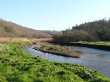
The source of the River Camel is at an altitide of 218 metres (715.2 ft) above sea level and has an average incline of 7m/km. The upper reaches of the Camel and its tributaries are mainly moorland giving way to woodland and farmland, predominantly livestock. This means that 64.8% of the catchment is grassland, with a further 14.8% arable land and 12.9% woodland. Of the remaining 7.4%, 4.5% is urban or built-up areas, 2.7% is mountain, heath and bog and the remainder is inland waters.
The catchment area of the River Camel covers a total of 413 km² on the western side of Bodmin Moor
, and is mainly Devonian slates and granite
, with some shales and sandstones. Water volumes are affected by the reservoir
at Crowdy Marsh, by abstraction of water for public supply, and by effluent from the sewage system around Bodmin
. Data collected by the National Water Archive shows that water flow in the River Camel for 2006 was considerably below average. This correlates with reduced rainfall, particularly between the months of June and September.
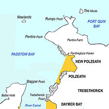
The River Camel's estuary
stretches from Wadebridge
downstream to the open sea at Padstow Bay. The quays at Wadebridge are now developed with apartments and retail space on the west bank. North of the quays, the river passes under a new concrete bridge carrying the A39
bypass and past the disused Vitriol Quay. Downstream of Burniere Point the valley widens on the right with acres of salt marsh
where the River Amble flows in. Here the Cornwall Birdwatching and Preservation Society have hides on both sides of the river; those on the Camel Trail being open to the public. The main river follows the western side of the valley, while on the eastern side a barrage prevents the rising tide from entering the River Amble.
Downstream from the Amble. a small test bore into Dinham Hill is only accessible from the foreshore at low tide. Cant Cove lies on the east bank below Cant Hill and the rotting ribs of a ship project from the mud. Almost opposite Cant Hill on the west bank is Camel Quarry, the piles of waste rock clearly visible above the river with the remains of a quay visible at low water. From here the mud gives way to sand and Gentle Jane, named after a legendary lady who treated the ills of all comers.
From Porthilly Cove
on the east bank, the estuary widens and swings to the north. On the east bank, the Camel Trail crosses the triple-span “Iron Bridge” over Little Petherick Creek
then passes below Dennis Hill with its obelisk.
The fishing port of Padstow
stands on the west bank. At this point, the Black Tor Ferry
(officially owned by the Duchy of Cornwall
) carries people across the river to Rock
.
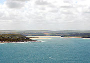
The mouth of the River Camel lies between Stepper Point
on the west and Pentire Point
on the east, and each headland shelters sandy beaches. On the west side of the eastuary, Tregirls beach is protected by Stepper Point. At the northern end of Tregirls beach is Harbour Cove and between here and Hawker's Cove
evidence has been found of occupation during the Bronze Age
, Iron Age
and Roman
periods, and use of Harbour Cove for trading vessels.
In 1827, Padstow Harbour Association chose Hawker's Cove as the location for the Padstow lifeboat
. Operations were taken over by the RNLI in 1856. A new lifeboat station and slipway were built in 1931 and a second lifeboat stationed at Hawker's Cove. The station closed in 1962 because silting rendered the channel too shallow. The building is now converted to residential use.
Beyond Hawkers Cove, the Doom Bar
extends across the estuary. This notorious sandbank has been the graveyard of many ships over the years. As with many things in Cornwall, there is a legend as to how the Doom Bar came about; a local fisherman is reputed to have shot a mermaid with an arrow, with the result that she cursed Padstow by putting this sandbar between the harbour and the sea.
On the east side of the estuary, the village of Rock
is popular centre for sailing
, dinghy racing
and marine leisure. From Rock, dunes and intertidal sands extend north as far as Brea Hill
. Beyond Brea Hill is Daymer Bay
with a popular beach north of which is the settlement of Trebetherick
. A stretch of rocky foreshore swings east to the bay and beach at Polzeath
, a populart location for surfing
. North of Polzeath, Pentire Point marks the northeast extremity of the estuary.
(AONB). This covers the area between Padstow/Rock and Wadebridge.
and Padstow
, while on the eastern bank moving upstream from Pentire Point
there is Polzeath
beach, Daymer Bay
and Rock
. Water quality is monitored at the latter three locations, results from 2007 being either "good" or "excellent".
, used by walkers and cyclists
, follows the trackbed of the old Bodmin and Wadebridge Railway
from Wenfordbridge
, past the outskirts of Bodmin
at Dunmere, and through Wadebridge
to end in Padstow
.
follows the River Camel from Pentire Point
to Rock
, and from Padstow
to Stepper Point
. It crosses the river using the Black Tor Ferry
.
The Saints' Way
footpath links Padstow
with Fowey
. It follows first the River Camel, and then Little Petherick Creek from Padstow to Little Petherick, before striking inland and crossing the county to the River Fowey
. This route is a very ancient one used by travellers from Ireland and Wales making for Brittany and wishing to avoid the dangerous seas around Lands End.
(SSSIs) along the length of the River Camel. Four small SSSIs at Harbour Cove, Rock Dunes
, Trebetherick Point
and Pentire Peninsula are on the estuary, while the River Camel Valley and Tributaries SSSI covers much of the Camel Valley between Egloshayle and Blisland
, and then extends in several further sections of varying size right up to its source. This SSSI also covers much of the River Allen, a tributary which flows into the river immediately upstream of Egloshayle, and also some smaller unnamed tributaries. In addition there is also an SSSI at Amble Marshes on the River Amble which flows into the Camel Estuary between Wadebridge and Rock.
The River Camel has been designated by the Joint Nature Conservation Committee
as a Special Area of Conservation as being of European importance for the Otter
and the Bullhead
.
There are two nature reserves on Camel and its tributaries. The Walmsley sanctuary of the Cornwall Birdwatching and Preservation Society is situated on the Amble marshes on the River Amble above Trewornan Bridge. Hawke's Wood reserve is owned by the Cornwall Wildlife Trust
and is situated on the south side of the Camel Valley between Wadebridge and Dunmere. Here there is an abandoned quarry in a mature woodland of predominantly Sessile Oak
.
, can be found on the Camel.
on the estuary
, the River Camel provides an excellent location for birds. Large flocks of wader
s can be seen in winter, preyed on by local Peregrine
s, and a migrant Osprey
often pauses a few days to fish in Spring and Autumn. Mute Swan
s nest at several locations, particularly near to the bridge in Wadebridge where there is often a nest on a small island a few yards downstream of the bridge. Ducks are also found on the river with Shelduck
, Shoveller and Mallard
on the estuary and Teal
further upstream.
The Camel estuary was one of the first places in England
to be colonised by Little Egret
s, the birds being particularly seen on mudflats at low tide. Other rarities include an American Belted kingfisher
seen in the 1980s for only the second time in England.
Upstream on the River Camel, and on several of its tributaries, Kingfisher
s can be seen, while the Cornwall Wildlife Trust reserve at Hawkes Wood is noted for Nuthatches and Tawney Owls.
There are two birdwatching hides on the River Camel. Tregunna Hide (Grid reference SW 969 738) is owned by Cornwall County Council and is located on the Camel Trail and is open to the public. Burniere Hide (Grid Reference SW 982 740) is owned by the Cornwall Birdwatching and Preservation Society (CBWPS) and is only open to members. In addition, the CBWPS own the Walmsley Sanctuary which covers over 20 hectares (49.4 acre) on the River Amble, a tributary of the River Camel, with a further 2 hides for use by its members. The sanctuary is nationally important for wintering waders and wildfowl.
is a Sea Bass
conservation area and these can be seen by surfers in summer. Flounders can be found in the brackish waters as far upstream as Cant Hill.
Salmon
and Sea Trout
can both be found in the River.
Occasionally Basking Shark
s can be seen in the mouth of the river and very occasionly bottlenose dolphins can be seen
the flora is distinctly maritime, characterised by Thrift
and Bladder campion on exposed clifftops and Spring squill and heather growing in the turf. Stunted Blackthorn
and Gorse
also tolerate more exposed sites, while the quarry on Stepper Point
is home to many species of marsh plants. Above Egloshayle there are beds of Yellow Flag Iris
while the wooded slopes of the valley are filled with Bluebells
in spring.
The Camel is also home to two particularly invasive non-native species; Japanese Knotweed
and Himalayan Balsam
. Both of these are the subject of manual control on various stretches of the river.
The river Camel and its tributaries are crossed by more Listed bridges than any other river in Cornwall.
, the Ruthern, the De Lank
and the Stannon. Other tributaries include the River Amble, which joins the Camel near Burniere Point and the Polmorla Brook which joins the Camel immediately above the bridge at Wadebridge.
In terms of its name there is evidence that what is now known as the River Camel has had several names in the past. The name Camel is derived from Middle Cornish "Cam-El", "Crooked one", and seems originally to have referred only to the upper parts.
The lower part of the river was referred to as the River Allen, a common Celtic river name of unknown derivation, however in the 19th Century the name Allen was transferred to the River Layne which flows into the Camel just above Egloshayle. The Camel estuary appears to have been called the River Hayle from Middle Cornish "Hayle", estuary and while this may have been as much a description as a proper name, the continued use of the name Hayle Bay for the bay containing Polzeath
beach supports this. In turn it has been suggested that the River Layne may have previously been called the River Dewi given the number of places along its course which contain the element.
Cornwall
Cornwall is a unitary authority and ceremonial county of England, within the United Kingdom. It is bordered to the north and west by the Celtic Sea, to the south by the English Channel, and to the east by the county of Devon, over the River Tamar. Cornwall has a population of , and covers an area of...
, UK
United Kingdom
The United Kingdom of Great Britain and Northern IrelandIn the United Kingdom and Dependencies, other languages have been officially recognised as legitimate autochthonous languages under the European Charter for Regional or Minority Languages...
. It rises on the edge of Bodmin Moor
Bodmin Moor
Bodmin Moor is a granite moorland in northeastern Cornwall, England, United Kingdom. It is in size, and originally dates from the Carboniferous period of geological history....
and together with its tributaries drains a considerable part of North Cornwall
Cornwall
Cornwall is a unitary authority and ceremonial county of England, within the United Kingdom. It is bordered to the north and west by the Celtic Sea, to the south by the English Channel, and to the east by the county of Devon, over the River Tamar. Cornwall has a population of , and covers an area of...
. The river issues into the Celtic Sea
Celtic Sea
The Celtic Sea is the area of the Atlantic Ocean off the south coast of Ireland bounded to the east by Saint George's Channel; other limits include the Bristol Channel, the English Channel, and the Bay of Biscay, as well as adjacent portions of Wales, Cornwall, Devon, and Brittany...
area of the Atlantic Ocean
Atlantic Ocean
The Atlantic Ocean is the second-largest of the world's oceanic divisions. With a total area of about , it covers approximately 20% of the Earth's surface and about 26% of its water surface area...
between Stepper Point
Stepper Point
Stepper Point is a headland on the Atlantic coast in north Cornwall, England, UK.Stepper Point and Pentire Point stand at either side of the mouth of the River Camel; Stepper to the south-west, Pentire to the north-east....
and Pentire Point
Pentire Point
Pentire Head is a headland and peninsula on the Atlantic coast in North Cornwall, England, UK and is approx one mile square. The headland projects north-west with Pentire Point at its north-west corner and The Rumps promontory at its north-east corner....
having covered a distance of approximately 30 miles. The river is tidal as far upstream as Egloshayle
Egloshayle
Egloshayle is a civil parish and village in north Cornwall, England, United Kingdom. The village is situated beside the River Camel immediately southeast of Wadebridge. The civil parish extends southeast from the village and includes Washaway and Sladesbridge.-History:Egloshayle was a Bronze Age...
and is popular for sailing
Sailing
Sailing is the propulsion of a vehicle and the control of its movement with large foils called sails. By changing the rigging, rudder, and sometimes the keel or centre board, a sailor manages the force of the wind on the sails in order to move the boat relative to its surrounding medium and...
, birdwatching
Birdwatching
Birdwatching or birding is the observation of birds as a recreational activity. It can be done with the naked eye, through a visual enhancement device like binoculars and telescopes, or by listening for bird sounds. Birding often involves a significant auditory component, as many bird species are...
and fishing
Fishing
Fishing is the activity of trying to catch wild fish. Fish are normally caught in the wild. Techniques for catching fish include hand gathering, spearing, netting, angling and trapping....
. The name Camel derives from the Cornish language
Cornish language
Cornish is a Brythonic Celtic language and a recognised minority language of the United Kingdom. Along with Welsh and Breton, it is directly descended from the ancient British language spoken throughout much of Britain before the English language came to dominate...
for 'the crooked one', a reference to its winding course.
Geology and hydrology
The River Camel rises on Hendraburnick Down (UK Grid Reference SX135875) on the edge of Bodmin MoorBodmin Moor
Bodmin Moor is a granite moorland in northeastern Cornwall, England, United Kingdom. It is in size, and originally dates from the Carboniferous period of geological history....
, an area which forms part of the granite
Granite
Granite is a common and widely occurring type of intrusive, felsic, igneous rock. Granite usually has a medium- to coarse-grained texture. Occasionally some individual crystals are larger than the groundmass, in which case the texture is known as porphyritic. A granitic rock with a porphyritic...
spine of Cornwall. The river's course is then through upper and middle Devonian
Devonian
The Devonian is a geologic period and system of the Paleozoic Era spanning from the end of the Silurian Period, about 416.0 ± 2.8 Mya , to the beginning of the Carboniferous Period, about 359.2 ± 2.5 Mya...
rocks, predominantly slates such as Upper Delabole Slates, Trevose Slates and Polzeath Slates. These stretch right to the coast, although Pentire head is composed mainly of pillow lavas. The only active quarry in the River Camel catchment area is Delabole
Delabole
Delabole is a large village in north Cornwall, England, UK. It is situated approximately two miles west of Camelford.The village of Delabole came into existence in the 20th century; it is named after the Delabole Quarry. There were three hamlets: Pengelly, Medrose and Rockhead...
Quarry although there has been mining for lead
Lead
Lead is a main-group element in the carbon group with the symbol Pb and atomic number 82. Lead is a soft, malleable poor metal. It is also counted as one of the heavy metals. Metallic lead has a bluish-white color after being freshly cut, but it soon tarnishes to a dull grayish color when exposed...
and antimony
Antimony
Antimony is a toxic chemical element with the symbol Sb and an atomic number of 51. A lustrous grey metalloid, it is found in nature mainly as the sulfide mineral stibnite...
on Pentire Head, as well as building stone at various locations. Further inland mines surrounding the Camel and its tributaries produced lead, copper
Copper
Copper is a chemical element with the symbol Cu and atomic number 29. It is a ductile metal with very high thermal and electrical conductivity. Pure copper is soft and malleable; an exposed surface has a reddish-orange tarnish...
and iron
Iron
Iron is a chemical element with the symbol Fe and atomic number 26. It is a metal in the first transition series. It is the most common element forming the planet Earth as a whole, forming much of Earth's outer and inner core. It is the fourth most common element in the Earth's crust...
, while Mulberry Mine near Ruthernbridge also produced tin
Tin
Tin is a chemical element with the symbol Sn and atomic number 50. It is a main group metal in group 14 of the periodic table. Tin shows chemical similarity to both neighboring group 14 elements, germanium and lead and has two possible oxidation states, +2 and the slightly more stable +4...
.
The source of the River Camel is at an altitide of 218 metres (715.2 ft) above sea level and has an average incline of 7m/km. The upper reaches of the Camel and its tributaries are mainly moorland giving way to woodland and farmland, predominantly livestock. This means that 64.8% of the catchment is grassland, with a further 14.8% arable land and 12.9% woodland. Of the remaining 7.4%, 4.5% is urban or built-up areas, 2.7% is mountain, heath and bog and the remainder is inland waters.
The catchment area of the River Camel covers a total of 413 km² on the western side of Bodmin Moor
Bodmin Moor
Bodmin Moor is a granite moorland in northeastern Cornwall, England, United Kingdom. It is in size, and originally dates from the Carboniferous period of geological history....
, and is mainly Devonian slates and granite
Granite
Granite is a common and widely occurring type of intrusive, felsic, igneous rock. Granite usually has a medium- to coarse-grained texture. Occasionally some individual crystals are larger than the groundmass, in which case the texture is known as porphyritic. A granitic rock with a porphyritic...
, with some shales and sandstones. Water volumes are affected by the reservoir
Crowdy Reservoir
Crowdy Reservoir is located on Bodmin Moor near Camelford in north Cornwall. It supplies water to the North Cornwall water distribution network via treatment at the Lowermoor Water Treatment Works. It is fed by run-off and drainage from surrounding moorland....
at Crowdy Marsh, by abstraction of water for public supply, and by effluent from the sewage system around Bodmin
Bodmin
Bodmin is a civil parish and major town in Cornwall, England, United Kingdom. It is situated in the centre of the county southwest of Bodmin Moor.The extent of the civil parish corresponds fairly closely to that of the town so is mostly urban in character...
. Data collected by the National Water Archive shows that water flow in the River Camel for 2006 was considerably below average. This correlates with reduced rainfall, particularly between the months of June and September.
Estuary
The River Camel's estuary
Estuary
An estuary is a partly enclosed coastal body of water with one or more rivers or streams flowing into it, and with a free connection to the open sea....
stretches from Wadebridge
Wadebridge
Wadebridge is a civil parish and town in north Cornwall, England, United Kingdom. The town straddles the River Camel five miles upstream from Padstow....
downstream to the open sea at Padstow Bay. The quays at Wadebridge are now developed with apartments and retail space on the west bank. North of the quays, the river passes under a new concrete bridge carrying the A39
A39 road
The A39 is an A road in south west England. It runs south-west from Bath in Somerset through Wells, Glastonbury, Street and Bridgwater. It then follows the north coast of Somerset and Devon through Williton, Minehead, Porlock, Lynmouth, Barnstaple, Bideford, Stratton, Camelford, Wadebridge and St...
bypass and past the disused Vitriol Quay. Downstream of Burniere Point the valley widens on the right with acres of salt marsh
Salt marsh
A salt marsh is an environment in the upper coastal intertidal zone between land and salt water or brackish water, it is dominated by dense stands of halophytic plants such as herbs, grasses, or low shrubs. These plants are terrestrial in origin and are essential to the stability of the salt marsh...
where the River Amble flows in. Here the Cornwall Birdwatching and Preservation Society have hides on both sides of the river; those on the Camel Trail being open to the public. The main river follows the western side of the valley, while on the eastern side a barrage prevents the rising tide from entering the River Amble.
Downstream from the Amble. a small test bore into Dinham Hill is only accessible from the foreshore at low tide. Cant Cove lies on the east bank below Cant Hill and the rotting ribs of a ship project from the mud. Almost opposite Cant Hill on the west bank is Camel Quarry, the piles of waste rock clearly visible above the river with the remains of a quay visible at low water. From here the mud gives way to sand and Gentle Jane, named after a legendary lady who treated the ills of all comers.
From Porthilly Cove
Porthilly
Porthilly is a small coastal settlement on the east side of the River Camel estuary in Cornwall, United Kingdom. It is situated immediately south of the larger village of Rock approximately four miles northwest of Wadebridge....
on the east bank, the estuary widens and swings to the north. On the east bank, the Camel Trail crosses the triple-span “Iron Bridge” over Little Petherick Creek
Little Petherick
Little Petherick is a village and civil parish in north Cornwall, United Kingdom. It is situated two miles south of Padstow and 6 miles west of Wadebridge....
then passes below Dennis Hill with its obelisk.
The fishing port of Padstow
Padstow
Padstow is a town, civil parish and fishing port on the north coast of Cornwall, England, United Kingdom. The town is situated on the west bank of the River Camel estuary approximately five miles northwest of Wadebridge, ten miles northwest of Bodmin and ten miles northeast of Newquay...
stands on the west bank. At this point, the Black Tor Ferry
Black Tor Ferry
The Black Tor Ferry, also known as the Padstow to Rock Ferry, is a passenger ferry which crosses the tidal River Camel in north Cornwall, United Kingdom. The ferry carries pedestrians and cyclists only .-History:...
(officially owned by the Duchy of Cornwall
Duchy of Cornwall
The Duchy of Cornwall is one of two royal duchies in England, the other being the Duchy of Lancaster. The eldest son of the reigning British monarch inherits the duchy and title of Duke of Cornwall at the time of his birth, or of his parent's succession to the throne. If the monarch has no son, the...
) carries people across the river to Rock
Rock, Cornwall
Rock is a coastal village in Cornwall, United Kingdom. It is situated opposite Padstow on the northeast bank of the River Camel estuary. The village is in the civil parish of St Minver Lowlands approximately four miles northwest of Wadebridge.-Geography:The main residential area is set back from...
.
The mouth of the River Camel lies between Stepper Point
Stepper Point
Stepper Point is a headland on the Atlantic coast in north Cornwall, England, UK.Stepper Point and Pentire Point stand at either side of the mouth of the River Camel; Stepper to the south-west, Pentire to the north-east....
on the west and Pentire Point
Pentire Point
Pentire Head is a headland and peninsula on the Atlantic coast in North Cornwall, England, UK and is approx one mile square. The headland projects north-west with Pentire Point at its north-west corner and The Rumps promontory at its north-east corner....
on the east, and each headland shelters sandy beaches. On the west side of the eastuary, Tregirls beach is protected by Stepper Point. At the northern end of Tregirls beach is Harbour Cove and between here and Hawker's Cove
Hawker's Cove, Cornwall
Hawker's Cove is a small coastal settlement in north Cornwall, United Kingdom. It is situated one-and-a-half miles north of Padstow on the west side of the River Camel estuary....
evidence has been found of occupation during the Bronze Age
Bronze Age
The Bronze Age is a period characterized by the use of copper and its alloy bronze as the chief hard materials in the manufacture of some implements and weapons. Chronologically, it stands between the Stone Age and Iron Age...
, Iron Age
Iron Age
The Iron Age is the archaeological period generally occurring after the Bronze Age, marked by the prevalent use of iron. The early period of the age is characterized by the widespread use of iron or steel. The adoption of such material coincided with other changes in society, including differing...
and Roman
Roman Britain
Roman Britain was the part of the island of Great Britain controlled by the Roman Empire from AD 43 until ca. AD 410.The Romans referred to the imperial province as Britannia, which eventually comprised all of the island of Great Britain south of the fluid frontier with Caledonia...
periods, and use of Harbour Cove for trading vessels.
In 1827, Padstow Harbour Association chose Hawker's Cove as the location for the Padstow lifeboat
Lifeboat (rescue)
A rescue lifeboat is a boat rescue craft which is used to attend a vessel in distress, or its survivors, to rescue crewmen and passengers. It can be hand pulled, sail powered or powered by an engine...
. Operations were taken over by the RNLI in 1856. A new lifeboat station and slipway were built in 1931 and a second lifeboat stationed at Hawker's Cove. The station closed in 1962 because silting rendered the channel too shallow. The building is now converted to residential use.
Beyond Hawkers Cove, the Doom Bar
Doom Bar
The Doom Bar is a bank of sand at the estuary of the River Camel where it meets the Celtic Sea on Cornwall's north coast. It represents a significant hazard to shipping, and there have been many ships wrecked there through the centuries...
extends across the estuary. This notorious sandbank has been the graveyard of many ships over the years. As with many things in Cornwall, there is a legend as to how the Doom Bar came about; a local fisherman is reputed to have shot a mermaid with an arrow, with the result that she cursed Padstow by putting this sandbar between the harbour and the sea.
On the east side of the estuary, the village of Rock
Rock, Cornwall
Rock is a coastal village in Cornwall, United Kingdom. It is situated opposite Padstow on the northeast bank of the River Camel estuary. The village is in the civil parish of St Minver Lowlands approximately four miles northwest of Wadebridge.-Geography:The main residential area is set back from...
is popular centre for sailing
Sailing
Sailing is the propulsion of a vehicle and the control of its movement with large foils called sails. By changing the rigging, rudder, and sometimes the keel or centre board, a sailor manages the force of the wind on the sails in order to move the boat relative to its surrounding medium and...
, dinghy racing
Dinghy racing
Dinghy racing is the competitive sport of sailing dinghies. Dinghy racing has affected aspects of the modern dinghy, including hull design, sail materials and sailplan, and techniques such as planing and trapezing.-Organisation of dinghy racing:...
and marine leisure. From Rock, dunes and intertidal sands extend north as far as Brea Hill
Brea Hill, Trebetherick
Brea Hill is a circular hill beside the River Camel estuary in north Cornwall, United Kingdom. The hill is high and there are Bronze Age tumuli at the summit...
. Beyond Brea Hill is Daymer Bay
Daymer Bay
Daymer Bay is a bay and a beach on the east side of the River Camel estuary in north Cornwall, United Kingdom. It is situated approximately six miles north of Wadebridge.Daymer Bay lies west of Trebetherick village at...
with a popular beach north of which is the settlement of Trebetherick
Trebetherick
Trebetherick is a village on the north coast of Cornwall, England, United Kingdom. It is situated on the east side of the River Camel estuary approximately six miles north of Wadebridge and half-a-mile south of Polzeath....
. A stretch of rocky foreshore swings east to the bay and beach at Polzeath
Polzeath
Polzeath is a small seaside resort in the civil parish of St Minver in Cornwall, United Kingdom. It is situated approximately six miles north of Wadebridge on the Atlantic coast....
, a populart location for surfing
Surfing
Surfing' is a surface water sport in which the surfer rides a surfboard on the crest and face of a wave which is carrying the surfer towards the shore...
. North of Polzeath, Pentire Point marks the northeast extremity of the estuary.
Recreation
The Camel Estuary has been designated an Area of Outstanding Natural BeautyArea of Outstanding Natural Beauty
An Area of Outstanding Natural Beauty is an area of countryside considered to have significant landscape value in England, Wales or Northern Ireland, that has been specially designated by the Countryside Agency on behalf of the United Kingdom government; the Countryside Council for Wales on...
(AONB). This covers the area between Padstow/Rock and Wadebridge.
Beaches and bathing
There are several sandy beaches located on the River Camel. On the western bank Tregirls beach and St Georges Well lie between Stepper PointStepper Point
Stepper Point is a headland on the Atlantic coast in north Cornwall, England, UK.Stepper Point and Pentire Point stand at either side of the mouth of the River Camel; Stepper to the south-west, Pentire to the north-east....
and Padstow
Padstow
Padstow is a town, civil parish and fishing port on the north coast of Cornwall, England, United Kingdom. The town is situated on the west bank of the River Camel estuary approximately five miles northwest of Wadebridge, ten miles northwest of Bodmin and ten miles northeast of Newquay...
, while on the eastern bank moving upstream from Pentire Point
Pentire Point
Pentire Head is a headland and peninsula on the Atlantic coast in North Cornwall, England, UK and is approx one mile square. The headland projects north-west with Pentire Point at its north-west corner and The Rumps promontory at its north-east corner....
there is Polzeath
Polzeath
Polzeath is a small seaside resort in the civil parish of St Minver in Cornwall, United Kingdom. It is situated approximately six miles north of Wadebridge on the Atlantic coast....
beach, Daymer Bay
Daymer Bay
Daymer Bay is a bay and a beach on the east side of the River Camel estuary in north Cornwall, United Kingdom. It is situated approximately six miles north of Wadebridge.Daymer Bay lies west of Trebetherick village at...
and Rock
Rock, Cornwall
Rock is a coastal village in Cornwall, United Kingdom. It is situated opposite Padstow on the northeast bank of the River Camel estuary. The village is in the civil parish of St Minver Lowlands approximately four miles northwest of Wadebridge.-Geography:The main residential area is set back from...
. Water quality is monitored at the latter three locations, results from 2007 being either "good" or "excellent".
The Camel Trail
The Camel TrailCamel Trail
The Camel Trail is a disused and resurfaced railway line in Cornwall, United Kingdom, that provides a recreational route for walkers, cyclists and horse riders...
, used by walkers and cyclists
Bicycle
A bicycle, also known as a bike, pushbike or cycle, is a human-powered, pedal-driven, single-track vehicle, having two wheels attached to a frame, one behind the other. A person who rides a bicycle is called a cyclist, or bicyclist....
, follows the trackbed of the old Bodmin and Wadebridge Railway
Bodmin and Wadebridge Railway
The Bodmin and Wadebridge Railway was a railway line opened in 1834 in Cornwall, United Kingdom. It linked the important town of Bodmin with the harbour at Wadebridge and also quarries at places such as Wenford...
from Wenfordbridge
Wenfordbridge
Wenfordbridge, or Wenford Bridge, is a hamlet some north of Bodmin and on the western flank of Bodmin Moor, in the English county of Cornwall...
, past the outskirts of Bodmin
Bodmin
Bodmin is a civil parish and major town in Cornwall, England, United Kingdom. It is situated in the centre of the county southwest of Bodmin Moor.The extent of the civil parish corresponds fairly closely to that of the town so is mostly urban in character...
at Dunmere, and through Wadebridge
Wadebridge
Wadebridge is a civil parish and town in north Cornwall, England, United Kingdom. The town straddles the River Camel five miles upstream from Padstow....
to end in Padstow
Padstow
Padstow is a town, civil parish and fishing port on the north coast of Cornwall, England, United Kingdom. The town is situated on the west bank of the River Camel estuary approximately five miles northwest of Wadebridge, ten miles northwest of Bodmin and ten miles northeast of Newquay...
.
Long distance footpaths
The South West Coast PathSouth West Coast Path
The South West Coast Path is Britain's longest waymarked long-distance footpath and a National Trail. It stretches for , running from Minehead in Somerset, along the coasts of Devon and Cornwall, to Poole Harbour in Dorset. Since it rises and falls with every river mouth, it is also one of the more...
follows the River Camel from Pentire Point
Pentire Point
Pentire Head is a headland and peninsula on the Atlantic coast in North Cornwall, England, UK and is approx one mile square. The headland projects north-west with Pentire Point at its north-west corner and The Rumps promontory at its north-east corner....
to Rock
Rock, Cornwall
Rock is a coastal village in Cornwall, United Kingdom. It is situated opposite Padstow on the northeast bank of the River Camel estuary. The village is in the civil parish of St Minver Lowlands approximately four miles northwest of Wadebridge.-Geography:The main residential area is set back from...
, and from Padstow
Padstow
Padstow is a town, civil parish and fishing port on the north coast of Cornwall, England, United Kingdom. The town is situated on the west bank of the River Camel estuary approximately five miles northwest of Wadebridge, ten miles northwest of Bodmin and ten miles northeast of Newquay...
to Stepper Point
Stepper Point
Stepper Point is a headland on the Atlantic coast in north Cornwall, England, UK.Stepper Point and Pentire Point stand at either side of the mouth of the River Camel; Stepper to the south-west, Pentire to the north-east....
. It crosses the river using the Black Tor Ferry
Black Tor Ferry
The Black Tor Ferry, also known as the Padstow to Rock Ferry, is a passenger ferry which crosses the tidal River Camel in north Cornwall, United Kingdom. The ferry carries pedestrians and cyclists only .-History:...
.
The Saints' Way
Saints' Way
The Saints' Way is a long-distance footpath in Cornwall, in the United Kingdom.The footpath runs from Padstow in the north to Fowey in the south, a distance of 26 miles . The path is well marked and guide books are available....
footpath links Padstow
Padstow
Padstow is a town, civil parish and fishing port on the north coast of Cornwall, England, United Kingdom. The town is situated on the west bank of the River Camel estuary approximately five miles northwest of Wadebridge, ten miles northwest of Bodmin and ten miles northeast of Newquay...
with Fowey
Fowey
Fowey is a small town, civil parish and cargo port at the mouth of the River Fowey in south Cornwall, United Kingdom. According to the 2001 census it had a population of 2,273.-Early history:...
. It follows first the River Camel, and then Little Petherick Creek from Padstow to Little Petherick, before striking inland and crossing the county to the River Fowey
River Fowey
The River Fowey is a river in Cornwall, United Kingdom.It rises about north-west of Brown Willy on Bodmin Moor, passes Lanhydrock House, Restormel Castle and Lostwithiel, then broadens at Milltown before joining the English Channel at Fowey. It is only navigable by larger craft for the last ....
. This route is a very ancient one used by travellers from Ireland and Wales making for Brittany and wishing to avoid the dangerous seas around Lands End.
Water sports
The section of the River Camel between and Tuckingmill Bridge and Penrose Bridge near Blisland is graded as Grade 2 for kayaking.Wildlife and conservation
There are 5 Sites of Special Scientific InterestSite of Special Scientific Interest
A Site of Special Scientific Interest is a conservation designation denoting a protected area in the United Kingdom. SSSIs are the basic building block of site-based nature conservation legislation and most other legal nature/geological conservation designations in Great Britain are based upon...
(SSSIs) along the length of the River Camel. Four small SSSIs at Harbour Cove, Rock Dunes
Rock, Cornwall
Rock is a coastal village in Cornwall, United Kingdom. It is situated opposite Padstow on the northeast bank of the River Camel estuary. The village is in the civil parish of St Minver Lowlands approximately four miles northwest of Wadebridge.-Geography:The main residential area is set back from...
, Trebetherick Point
Trebetherick
Trebetherick is a village on the north coast of Cornwall, England, United Kingdom. It is situated on the east side of the River Camel estuary approximately six miles north of Wadebridge and half-a-mile south of Polzeath....
and Pentire Peninsula are on the estuary, while the River Camel Valley and Tributaries SSSI covers much of the Camel Valley between Egloshayle and Blisland
Blisland
Blisland is a village and civil parish in Cornwall, England, United Kingdom. It is approximately five miles northeast of Bodmin. According to the 2001 census, the parish had a population of 565....
, and then extends in several further sections of varying size right up to its source. This SSSI also covers much of the River Allen, a tributary which flows into the river immediately upstream of Egloshayle, and also some smaller unnamed tributaries. In addition there is also an SSSI at Amble Marshes on the River Amble which flows into the Camel Estuary between Wadebridge and Rock.
The River Camel has been designated by the Joint Nature Conservation Committee
Joint Nature Conservation Committee
The Joint Nature Conservation Committee is the statutory adviser to the UK Government on national and international nature conservation. Its work contributes to maintaining and enriching biological diversity, conserving geological features and sustaining natural systems...
as a Special Area of Conservation as being of European importance for the Otter
Otter
The Otters are twelve species of semi-aquatic mammals which feed on fish and shellfish, and also other invertebrates, amphibians, birds and small mammals....
and the Bullhead
European bullhead
The bullhead is a freshwater fish that is widely distributed in Europe, mainly in rivers. It is a member of the Cottidae family, a type of sculpin...
.
There are two nature reserves on Camel and its tributaries. The Walmsley sanctuary of the Cornwall Birdwatching and Preservation Society is situated on the Amble marshes on the River Amble above Trewornan Bridge. Hawke's Wood reserve is owned by the Cornwall Wildlife Trust
Cornwall Wildlife Trust
The Cornwall Wildlife Trust is a charitable organisation founded in 1962 that is concerned solely with Cornwall, United Kingdom.It deals with the conservation and preservation of Cornwall's wildlife and habitats managing over 50 nature reserves covering approximately , amongst them Looe...
and is situated on the south side of the Camel Valley between Wadebridge and Dunmere. Here there is an abandoned quarry in a mature woodland of predominantly Sessile Oak
Sessile Oak
Quercus petraea , the Sessile Oak, also known as the Durmast Oak, is a species of oak native to most of Europe, and into Anatolia.-Description:...
.
Animals
Although very few British animals rely largely on rivers for their habitat, one of the few that do, the otterOtter
The Otters are twelve species of semi-aquatic mammals which feed on fish and shellfish, and also other invertebrates, amphibians, birds and small mammals....
, can be found on the Camel.
Birds
With the large areas of salt marshSalt marsh
A salt marsh is an environment in the upper coastal intertidal zone between land and salt water or brackish water, it is dominated by dense stands of halophytic plants such as herbs, grasses, or low shrubs. These plants are terrestrial in origin and are essential to the stability of the salt marsh...
on the estuary
Estuary
An estuary is a partly enclosed coastal body of water with one or more rivers or streams flowing into it, and with a free connection to the open sea....
, the River Camel provides an excellent location for birds. Large flocks of wader
Wader
Waders, called shorebirds in North America , are members of the order Charadriiformes, excluding the more marine web-footed seabird groups. The latter are the skuas , gulls , terns , skimmers , and auks...
s can be seen in winter, preyed on by local Peregrine
Peregrine Falcon
The Peregrine Falcon , also known as the Peregrine, and historically as the Duck Hawk in North America, is a widespread bird of prey in the family Falconidae. A large, crow-sized falcon, it has a blue-gray back, barred white underparts, and a black head and "moustache"...
s, and a migrant Osprey
Osprey
The Osprey , sometimes known as the sea hawk or fish eagle, is a diurnal, fish-eating bird of prey. It is a large raptor, reaching more than in length and across the wings...
often pauses a few days to fish in Spring and Autumn. Mute Swan
Mute Swan
The Mute Swan is a species of swan, and thus a member of the duck, goose and swan family Anatidae. It is native to much of Europe and Asia, and the far north of Africa. It is also an introduced species in North America, Australasia and southern Africa. The name 'mute' derives from it being less...
s nest at several locations, particularly near to the bridge in Wadebridge where there is often a nest on a small island a few yards downstream of the bridge. Ducks are also found on the river with Shelduck
Shelduck
The shelducks, genus Tadorna, are a group of large birds in the Tadorninae subfamily of the Anatidae, the biological family that includes the ducks and most duck-like waterfowl such as the geese and swans....
, Shoveller and Mallard
Mallard
The Mallard , or Wild Duck , is a dabbling duck which breeds throughout the temperate and subtropical Americas, Europe, Asia, and North Africa, and has been introduced to New Zealand and Australia....
on the estuary and Teal
Teal
Teal may mean:* Teal , a medium greenish-blue color* Various ducks:** Baikal Teal, Anas formosa** Black Teal, Aythya novaeseelandiae** Blue-winged Teal, Anas discors** Brown Teal, Anas aucklandica** Campbell Teal Anas nesiotis...
further upstream.
The Camel estuary was one of the first places in England
England
England is a country that is part of the United Kingdom. It shares land borders with Scotland to the north and Wales to the west; the Irish Sea is to the north west, the Celtic Sea to the south west, with the North Sea to the east and the English Channel to the south separating it from continental...
to be colonised by Little Egret
Little Egret
The Little Egret is a small white heron. It is the Old World counterpart to the very similar New World Snowy Egret.-Subspecies:Depending on authority, two or three subspecies of Little Egret are currently accepted....
s, the birds being particularly seen on mudflats at low tide. Other rarities include an American Belted kingfisher
Belted Kingfisher
The Belted Kingfisher is a large, conspicuous water kingfisher, the only member of that group commonly found in the northern United States and Canada. It is depicted on the 1986 series Canadian $5 note. All kingfishers were formerly placed in one family, Alcedinidae, but recent research suggests...
seen in the 1980s for only the second time in England.
Upstream on the River Camel, and on several of its tributaries, Kingfisher
Kingfisher
Kingfishers are a group of small to medium sized brightly coloured birds in the order Coraciiformes. They have a cosmopolitan distribution, with most species being found in the Old World and Australia...
s can be seen, while the Cornwall Wildlife Trust reserve at Hawkes Wood is noted for Nuthatches and Tawney Owls.
There are two birdwatching hides on the River Camel. Tregunna Hide (Grid reference SW 969 738) is owned by Cornwall County Council and is located on the Camel Trail and is open to the public. Burniere Hide (Grid Reference SW 982 740) is owned by the Cornwall Birdwatching and Preservation Society (CBWPS) and is only open to members. In addition, the CBWPS own the Walmsley Sanctuary which covers over 20 hectares (49.4 acre) on the River Amble, a tributary of the River Camel, with a further 2 hides for use by its members. The sanctuary is nationally important for wintering waders and wildfowl.
Fish
The Camel EstuaryEstuary
An estuary is a partly enclosed coastal body of water with one or more rivers or streams flowing into it, and with a free connection to the open sea....
is a Sea Bass
European seabass
The European seabass, Dicentrarchus labrax, also known as Morone labrax, is a primarily ocean-going fish that sometimes enters brackish and fresh waters. It is also known as the sea dace...
conservation area and these can be seen by surfers in summer. Flounders can be found in the brackish waters as far upstream as Cant Hill.
Salmon
Salmon
Salmon is the common name for several species of fish in the family Salmonidae. Several other fish in the same family are called trout; the difference is often said to be that salmon migrate and trout are resident, but this distinction does not strictly hold true...
and Sea Trout
Brown trout
The brown trout and the sea trout are fish of the same species....
can both be found in the River.
Occasionally Basking Shark
Basking shark
The basking shark is the second largest living fish, after the whale shark. It is a cosmopolitan migratory species, found in all the world's temperate oceans. It is a slow moving and generally harmless filter feeder and has anatomical adaptations to filter feeding, such as a greatly enlarged...
s can be seen in the mouth of the river and very occasionly bottlenose dolphins can be seen
Flora
By the Atlantic OceanAtlantic Ocean
The Atlantic Ocean is the second-largest of the world's oceanic divisions. With a total area of about , it covers approximately 20% of the Earth's surface and about 26% of its water surface area...
the flora is distinctly maritime, characterised by Thrift
Armeria maritima
Armeria maritima is the botanical name for a species of flowering plant.It is a popular garden flower, known by several common names, including thrift, sea thrift, and sea pink. The plant has been distributed worldwide as a garden and cut flower...
and Bladder campion on exposed clifftops and Spring squill and heather growing in the turf. Stunted Blackthorn
Blackthorn
Prunus spinosa is a species of Prunus native to Europe, western Asia, and locally in northwest Africa. It is also locally naturalised in New Zealand and eastern North America....
and Gorse
Gorse
Gorse, furze, furse or whin is a genus of about 20 plant species of thorny evergreen shrubs in the subfamily Faboideae of the pea family Fabaceae, native to western Europe and northwest Africa, with the majority of species in Iberia.Gorse is closely related to the brooms, and like them, has green...
also tolerate more exposed sites, while the quarry on Stepper Point
Stepper Point
Stepper Point is a headland on the Atlantic coast in north Cornwall, England, UK.Stepper Point and Pentire Point stand at either side of the mouth of the River Camel; Stepper to the south-west, Pentire to the north-east....
is home to many species of marsh plants. Above Egloshayle there are beds of Yellow Flag Iris
Iris pseudacorus
Iris pseudacorus is a species of Iris, native to Europe, western Asia and northwest Africa. Common names include yellow iris and yellow flag...
while the wooded slopes of the valley are filled with Bluebells
Common Bluebell
Hyacinthoides non-scripta, commonly known as the common bluebell, is a spring-flowering bulbous perennial plant. -Taxonomy:...
in spring.
The Camel is also home to two particularly invasive non-native species; Japanese Knotweed
Japanese knotweed
Japanese Knotweed is a large, herbaceous perennial plant, native to eastern Asia in Japan, China and Korea...
and Himalayan Balsam
Himalayan Balsam
Impatiens glandulifera is a large annual plant native to the Himalayas. Via human introduction it is now extant across much of the Northern Hemisphere.-Etymology:...
. Both of these are the subject of manual control on various stretches of the river.
History and infrastructure
Cornwall is a county of high cliffs and deep valleys, so rivers have been used for transport throughout history. Being one of the few safe havens on the north coast of Cornwall, the Camel Estuary has been used since Roman times, and most likely earlier. The river has been navigable beyond Wadebridge with the highest quay being at Guineaport, and then beyond that at least as far as Pendavy a mile further upstream.The river Camel and its tributaries are crossed by more Listed bridges than any other river in Cornwall.
Tributaries and their names
The main tributaries of the River Camel are the AllenRiver Allen, Cornwall
The River Allen in north Cornwall is one of two rivers of the same name in Cornwall in southwest England which share this name.The River Allen is a major tributary of the River Camel. It springs norrtheast of Camelford and flows south-southwest through the Allen Valley passing St Teath and St Kew...
, the Ruthern, the De Lank
De Lank River
The De Lank River is a small river in north Cornwall, United Kingdom. It is a tributary of the River Camel and is approximately nine miles long from its source on Bodmin Moor to its confluence with the Camel two miles south of St Breward.The De Lank River springs from Rough Tor Marsh between the...
and the Stannon. Other tributaries include the River Amble, which joins the Camel near Burniere Point and the Polmorla Brook which joins the Camel immediately above the bridge at Wadebridge.
In terms of its name there is evidence that what is now known as the River Camel has had several names in the past. The name Camel is derived from Middle Cornish "Cam-El", "Crooked one", and seems originally to have referred only to the upper parts.
The lower part of the river was referred to as the River Allen, a common Celtic river name of unknown derivation, however in the 19th Century the name Allen was transferred to the River Layne which flows into the Camel just above Egloshayle. The Camel estuary appears to have been called the River Hayle from Middle Cornish "Hayle", estuary and while this may have been as much a description as a proper name, the continued use of the name Hayle Bay for the bay containing Polzeath
Polzeath
Polzeath is a small seaside resort in the civil parish of St Minver in Cornwall, United Kingdom. It is situated approximately six miles north of Wadebridge on the Atlantic coast....
beach supports this. In turn it has been suggested that the River Layne may have previously been called the River Dewi given the number of places along its course which contain the element.