The Rumps
Encyclopedia

Headlands and bays
Headlands and bays are two related features of the coastal environment.- Geology and geography :Headlands and bays are often found on the same coastline. A bay is surrounded by land on three sides, whereas a headland is surrounded by water on three sides. Headlands are characterized by high,...
promontory at the north-east corner of Pentire Head in north Cornwall
Cornwall
Cornwall is a unitary authority and ceremonial county of England, within the United Kingdom. It is bordered to the north and west by the Celtic Sea, to the south by the English Channel, and to the east by the county of Devon, over the River Tamar. Cornwall has a population of , and covers an area of...
, United Kingdom
United Kingdom
The United Kingdom of Great Britain and Northern IrelandIn the United Kingdom and Dependencies, other languages have been officially recognised as legitimate autochthonous languages under the European Charter for Regional or Minority Languages...
.
The promontory is formed from hard basalt
Basalt
Basalt is a common extrusive volcanic rock. It is usually grey to black and fine-grained due to rapid cooling of lava at the surface of a planet. It may be porphyritic containing larger crystals in a fine matrix, or vesicular, or frothy scoria. Unweathered basalt is black or grey...
ic rock (see also Geology of Cornwall
Geology of Cornwall
The Geology of Cornwall is dominated by its granite backbone, part of the Cornubian batholith, formed during the Variscan orogeny. Around this is an extensive metamorphic aureole formed in the mainly Devonian slates that make up most of the rest of the county...
) and projects north into the Atlantic Ocean
Atlantic Ocean
The Atlantic Ocean is the second-largest of the world's oceanic divisions. With a total area of about , it covers approximately 20% of the Earth's surface and about 26% of its water surface area...
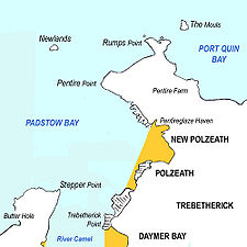
. Its headlands lie east-to-west. A small offshore island named The Mouls lies off the eastern headland; the western headland is named Rumps Point.
Access to The Rumps is via the South West Coast Path
South West Coast Path
The South West Coast Path is Britain's longest waymarked long-distance footpath and a National Trail. It stretches for , running from Minehead in Somerset, along the coasts of Devon and Cornwall, to Poole Harbour in Dorset. Since it rises and falls with every river mouth, it is also one of the more...
from Polzeath
Polzeath
Polzeath is a small seaside resort in the civil parish of St Minver in Cornwall, United Kingdom. It is situated approximately six miles north of Wadebridge on the Atlantic coast....
or by an inland public footpath from the car park at Pentire Farm. The entire Pentire headland, including The Rumps, is under the stewardship of the National Trust
National Trust for Places of Historic Interest or Natural Beauty
The National Trust for Places of Historic Interest or Natural Beauty, usually known as the National Trust, is a conservation organisation in England, Wales and Northern Ireland...
. Sightseeing boat tours regularly sail around The Rumps from the nearby port of Padstow
Padstow
Padstow is a town, civil parish and fishing port on the north coast of Cornwall, England, United Kingdom. The town is situated on the west bank of the River Camel estuary approximately five miles northwest of Wadebridge, ten miles northwest of Bodmin and ten miles northeast of Newquay...
.
Iron Age fort
The Rumps is the site of an Iron AgeIron Age
The Iron Age is the archaeological period generally occurring after the Bronze Age, marked by the prevalent use of iron. The early period of the age is characterized by the widespread use of iron or steel. The adoption of such material coincided with other changes in society, including differing...
promontory fort
Promontory fort
A promontory fort is a defensive structure located above a steep cliff, often only connected to the mainland by a small neck of land, thus utilizing the topography to reduce the ramparts needed. Although their dating is problematic, most seem to date to the Iron Age...
. The fort was the subject of an archeological survey and the findings were published in 1974 in Cornish Archaeology, 13, pp 5-50. The twin headlands are linked to the mainland by a narrow neck making The Rumps a formidably defensive site.
Three ramparts (banks and ditches) span the narrowest part of the promontory. These date from the late Iron Age and were once topped by wooden palisades; the earthworks remain clearly visible to walkers.
For The Fallen
The poet Laurence BinyonLaurence Binyon
Robert Laurence Binyon was an English poet, dramatist and art scholar. His most famous work, For the Fallen, is well known for being used in Remembrance Sunday services....
wrote For the Fallen in 1914 while sitting on the cliffs between Pentire Point and The Rumps. A stone plaque was erected at the spot in 2001 to commemorate the fact. The plaque bears an inscription which reads For The Fallen composed on these cliffs 1914 and quotes the stanza popularly known as The Ode.
External links
- Photographs and information from Strolling Guides
- Historic Cornwall website Article on The Rumps fortifications

