
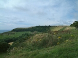
Swyre Head
Encyclopedia
- See also Swyre HeadSwyre Head, LulworthSwyre Head, Lulworth lies on the Jurassic Coast between Bat's Head to the west and Durdle Door to the east, close to Lulworth in Dorset, England...
near Durdle DoorDurdle DoorDurdle Door is a natural limestone arch on the Jurassic Coast near Lulworth in Dorset, England. It is privately owned by the Welds, a family who own in Dorset in the name of the Lulworth Estate. It is open to the public...
.
Swyre Head is the highest point of the Purbeck Hills
Purbeck Hills
The Purbeck Hills and South Dorset Downs are a ridge of chalk downs in Dorset, England. The hills extend from the Dorset Downs west of Dorchester, where the River Frome begins to form a valley dividing them from the larger area of downland to the north. The ridge then runs east through the Isle...
and the Isle of Purbeck
Isle of Purbeck
The Isle of Purbeck, not a true island but a peninsula, is in the county of Dorset, England. It is bordered by the English Channel to the south and east, where steep cliffs fall to the sea; and by the marshy lands of the River Frome and Poole Harbour to the north. Its western boundary is less well...
in Dorset
Dorset
Dorset , is a county in South West England on the English Channel coast. The county town is Dorchester which is situated in the south. The Hampshire towns of Bournemouth and Christchurch joined the county with the reorganisation of local government in 1974...
, on the south coast of England
England
England is a country that is part of the United Kingdom. It shares land borders with Scotland to the north and Wales to the west; the Irish Sea is to the north west, the Celtic Sea to the south west, with the North Sea to the east and the English Channel to the south separating it from continental...
. The hill Swyre Head lies about two kilometres southwest of the village Kingston
Kingston, Purbeck, Dorset
Kingston is a small village on the Isle of Purbeck in the county of Dorset in southern England.-Location:Kingston is situated about two miles south of Corfe Castle and five miles west of Swanage. The village of Kingston is situated on a hill near Swyre Head, the highest point of the Purbeck Hills...
, about five kilometres south of Corfe Castle and eight kilometres west of Swanage
Swanage
Swanage is a coastal town and civil parish in the south east of Dorset, England. It is situated at the eastern end of the Isle of Purbeck, approximately 10 km south of Poole and 40 km east of Dorchester. The parish has a population of 10,124 . Nearby are Ballard Down and Old Harry Rocks,...
.
Although not very high, its relative height is such that it qualifies as a Marilyn
Marilyn (hill)
A Marilyn is a mountain or hill in the United Kingdom, Republic of Ireland or Isle of Man with a relative height of at least 150 metres , regardless of absolute height or other merit...
. The chalk hill is part of the extensive Southern England Chalk Formation
Southern England Chalk Formation
The Chalk Formation of Southern England is a system of chalk downland in the south of England. The formation is perhaps best known for Salisbury Plain, the location of Stonehenge, the Isle of Wight and the twin ridgeways of the North Downs and South Downs....
.
Durdle Door
Durdle Door is a natural limestone arch on the Jurassic Coast near Lulworth in Dorset, England. It is privately owned by the Welds, a family who own in Dorset in the name of the Lulworth Estate. It is open to the public...
. The two Swyre Heads are about four hours walk apart from each other (18 kilometers).
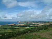
The hill commands extensive views, including west past the Isle of Portland
Isle of Portland
The Isle of Portland is a limestone tied island, long by wide, in the English Channel. Portland is south of the resort of Weymouth, forming the southernmost point of the county of Dorset, England. A tombolo over which runs the A354 road connects it to Chesil Beach and the mainland. Portland and...
to Dartmoor
Dartmoor
Dartmoor is an area of moorland in south Devon, England. Protected by National Park status, it covers .The granite upland dates from the Carboniferous period of geological history. The moorland is capped with many exposed granite hilltops known as tors, providing habitats for Dartmoor wildlife. The...
, and east to the Isle of Wight
Isle of Wight
The Isle of Wight is a county and the largest island of England, located in the English Channel, on average about 2–4 miles off the south coast of the county of Hampshire, separated from the mainland by a strait called the Solent...
, as well as north across the Purbeck Hills to Poole Harbour
Poole Harbour
Poole Harbour is a large natural harbour in Dorset, southern England, with the town of Poole on its shores. The harbour is a drowned valley formed at the end of the last ice age and is the estuary of several rivers, the largest being the Frome. The harbour has a long history of human settlement...
and the other Purbeck Marilyn, Nine Barrow Down
Nine Barrow Down
Nine Barrow Down is an elongated hill forming the northern ridge of the Purbeck Hills on the Isle of Purbeck in Dorset, England. The chalk down is part of the extensive Southern England Chalk Formation. The eastern end of the ridge, which carries the highest point, is also sometimes known as...
. To the west, the folly of Clavell Tower
Clavell Tower
Clavell Tower, also known as Clavell Folly or the Kimmeridge Tower, is a Grade II listed Tuscan style tower built in 1830. It lies on the Jurassic Coast, on the top of Hen Cliff just east of Kimmeridge Bay in the Isle of Purbeck in Dorset, England.-History:...
can also be seen.
Set back about 800 metres (half a mile) from the coast, the hill is not on the South West Coast Path
South West Coast Path
The South West Coast Path is Britain's longest waymarked long-distance footpath and a National Trail. It stretches for , running from Minehead in Somerset, along the coasts of Devon and Cornwall, to Poole Harbour in Dorset. Since it rises and falls with every river mouth, it is also one of the more...
, but can be reached easily from the villages of Kingston
Kingston, Purbeck, Dorset
Kingston is a small village on the Isle of Purbeck in the county of Dorset in southern England.-Location:Kingston is situated about two miles south of Corfe Castle and five miles west of Swanage. The village of Kingston is situated on a hill near Swyre Head, the highest point of the Purbeck Hills...
or Kimmeridge
Kimmeridge
Kimmeridge is a small village in the Purbeck district of Dorset, England, situated on the English Channel coast. Kimmeridge is about south of Wareham and about west of Swanage and is on the Isle of Purbeck...
.
The hill has a trig point
Trig point
A triangulation station, also known as a triangulation pillar, trigonometrical station, trigonometrical point, trig station, trig beacon or trig point, and sometimes informally as a trig, is a fixed surveying station, used in geodetic surveying and other surveying projects in its vicinity...
marked as 203 metres on Ordnance Survey
Ordnance Survey
Ordnance Survey , an executive agency and non-ministerial government department of the Government of the United Kingdom, is the national mapping agency for Great Britain, producing maps of Great Britain , and one of the world's largest producers of maps.The name reflects its creation together with...
maps, but a tumulus
Tumulus
A tumulus is a mound of earth and stones raised over a grave or graves. Tumuli are also known as barrows, burial mounds, Hügelgrab or kurgans, and can be found throughout much of the world. A tumulus composed largely or entirely of stones is usually referred to as a cairn...
, now fully grassed over, forms the highest point, 208 metres above sea level.