

1066 Country Walk
Encyclopedia
England
England is a country that is part of the United Kingdom. It shares land borders with Scotland to the north and Wales to the west; the Irish Sea is to the north west, the Celtic Sea to the south west, with the North Sea to the east and the English Channel to the south separating it from continental...
, United Kingdom
United Kingdom
The United Kingdom of Great Britain and Northern IrelandIn the United Kingdom and Dependencies, other languages have been officially recognised as legitimate autochthonous languages under the European Charter for Regional or Minority Languages...
.
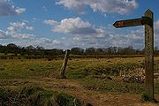
The route
The route commemorates 1066, the year of the Battle of HastingsBattle of Hastings
The Battle of Hastings occurred on 14 October 1066 during the Norman conquest of England, between the Norman-French army of Duke William II of Normandy and the English army under King Harold II...
, and seeks to link the places and the people of that important year. It runs through East Sussex
East Sussex
East Sussex is a county in South East England. It is bordered by the counties of Kent, Surrey and West Sussex, and to the south by the English Channel.-History:...
from Pevensey
Pevensey
Pevensey is a village and civil parish in the Wealden district of East Sussex, England. The main village is located 5 miles north-east of Eastbourne, one mile inland from Pevensey Bay. The settlement of Pevensey Bay forms part of the parish.-Geography:The village of Pevensey is located on...
where William of Normandy gathered his invading army of Normans
Normans
The Normans were the people who gave their name to Normandy, a region in northern France. They were descended from Norse Viking conquerors of the territory and the native population of Frankish and Gallo-Roman stock...
and prepared to meet King Harold
Harold Godwinson
Harold Godwinson was the last Anglo-Saxon King of England.It could be argued that Edgar the Atheling, who was proclaimed as king by the witan but never crowned, was really the last Anglo-Saxon king...
to Rye, East Sussex
Rye, East Sussex
Rye is a small town in East Sussex, England, which stands approximately two miles from the open sea and is at the confluence of three rivers: the Rother, the Tillingham and the Brede...
, passing through Battle, East Sussex
Battle, East Sussex
Battle is a small town and civil parish in the local government district of Rother in East Sussex, England. It lies south southeast of London, east of Brighton and east of the county town of Lewes...
.
The walk is mainly low level and passes through rolling countryside beside oast house
Oast house
An oast, oast house or hop kiln is a building designed for kilning hops as part of the brewing process. They can be found in most hop-growing areas and are often good examples of vernacular architecture...
s, windmill
Windmill
A windmill is a machine which converts the energy of wind into rotational energy by means of vanes called sails or blades. Originally windmills were developed for milling grain for food production. In the course of history the windmill was adapted to many other industrial uses. An important...
s and parts of the South Downs
South Downs
The South Downs is a range of chalk hills that extends for about across the south-eastern coastal counties of England from the Itchen Valley of Hampshire in the west to Beachy Head, near Eastbourne, East Sussex, in the east. It is bounded on its northern side by a steep escarpment, from whose...
.
It links with the Saxon Shore Way
Saxon Shore Way
The Saxon Shore Way is a long-distance footpath in England, starting at Gravesend, Kent and traces the coast as it was in Roman times as far as Hastings, East Sussex, in total.-History:...
.
External links
Further reading
- The 1066 Country Walk Book official guide by Brian Smailes. Challenge Publications ISBN 1-903568-00-5