

Boscastle flood of 2004
Encyclopedia
Boscastle
Boscastle is a village and fishing port on the north coast of Cornwall, England, in the civil parish of Forrabury and Minster. It is situated 14 miles south of Bude and 5 miles north-east of Tintagel....
and Crackington Haven
Crackington Haven
Crackington Haven is a coastal village in Cornwall, United Kingdom. It is located in the civil parish of St Gennys at at the head of a cove on the Atlantic coast. The village is seven miles south-southwest of Bude and four miles north-northeast of Boscastle.Middle Crackington and Higher...
in Cornwall
Cornwall
Cornwall is a unitary authority and ceremonial county of England, within the United Kingdom. It is bordered to the north and west by the Celtic Sea, to the south by the English Channel, and to the east by the county of Devon, over the River Tamar. Cornwall has a population of , and covers an area of...
, England
England
England is a country that is part of the United Kingdom. It shares land borders with Scotland to the north and Wales to the west; the Irish Sea is to the north west, the Celtic Sea to the south west, with the North Sea to the east and the English Channel to the south separating it from continental...
, United Kingdom. The villages suffered extensive damage after flash flood
Flash flood
A flash flood is a rapid flooding of geomorphic low-lying areas—washes, rivers, dry lakes and basins. It may be caused by heavy rain associated with a storm, hurricane, or tropical storm or meltwater from ice or snow flowing over ice sheets or snowfields...
s caused by an exceptional amount of rain that fell over eight hours that afternoon. The flood in Boscastle was filmed and extensively reported but the floods in Crackington Haven and Rocky Valley were not mentioned beyond the local news. The floods were the worst in local memory. A study commissioned by the Environment Agency
Environment Agency
The Environment Agency is a British non-departmental public body of the Department for Environment, Food and Rural Affairs and an Assembly Government Sponsored Body of the Welsh Assembly Government that serves England and Wales.-Purpose:...
from hydraulics consulting firm HR Wallingford concluded that it was among the most extreme ever experienced in Britain. The peak flow was about 140 m³/s, between 5:00pm and 6:00pm BST. The annual chance of this (or a greater) flood in any one year is about 1 in 400. The probability each year of the heaviest three-hour rainfall is about 1 in 1300 (although rainfall probability is not the same as flood probability).
At midday on the 16th August 2004, heavy thundery showers had developed across the South West; these were the remnants of Hurricane Alex (2004)
Hurricane Alex (2004)
Hurricane Alex was the first named storm, the first hurricane, and the first major hurricane of the 2004 Atlantic hurricane season. The first storm of the season, Alex formed unusually late in the season; the fifth latest since 1954. It developed from the interaction between an upper-level low and...
which had crossed the Atlantic.
The last time Boscastle had suffered notable flooding was in 1996 as a result of Hurricane Lili
Hurricane Lili (1996)
Hurricane Lili was a relatively long-lived hurricane during the very active 1996 Atlantic hurricane season. Lili formed on October 14 from a tropical wave, which emerged from the coast of west Africa on October 4. The tropical wave which developed into Lili was slow to form due to unfavorable wind...
, but floods are recorded in 1847, 1957, 3 June 1958 (one man drowned) and 1963. On 16 August 1952 the small town of Lynmouth
Lynmouth
Lynmouth is a village in Devon, England, on the north edge of Exmoor.The village straddles the confluence of the West Lyn and East Lyn rivers, in a gorge below Lynton, to which it is connected by the Lynton and Lynmouth Cliff Railway....
, 50 miles (80.5 km) north-east along the north coast in Devon
Devon
Devon is a large county in southwestern England. The county is sometimes referred to as Devonshire, although the term is rarely used inside the county itself as the county has never been officially "shired", it often indicates a traditional or historical context.The county shares borders with...
near Exmoor
Exmoor
Exmoor is an area of hilly open moorland in west Somerset and north Devon in South West England, named after the main river that flows out of the district, the River Exe. The moor has given its name to a National Park, which includes the Brendon Hills, the East Lyn Valley, the Vale of Porlock and ...
, suffered extensive damage in a catastrophic flood, in which 34 people lost their lives. Coincidentally, this was 52 years to the day before Boscastle's 2004 flood.
Causes of the flood
On the 16th, warm air picking up moisture - due to residual heat from the Atlantic sea - travelled towards the South West Cornish coast as prevailing winds. Upon contact with the topographically vertical coast, these winds experienced a strong up-drafting force thus causing internal moisture to reach the atmosphere, and consequently cool as a string of storm clouds. With convergence and coalescence, enhanced moisture levels resulted in heavy rainfall on the afternoon of 16 August 2004. 185 mm (7 inches) of rain fell over the high ground just inland of Boscastle. At the peak of the downpour, at about 15:40 GMTGreenwich Mean Time
Greenwich Mean Time is a term originally referring to mean solar time at the Royal Observatory in Greenwich, London. It is arguably the same as Coordinated Universal Time and when this is viewed as a time zone the name Greenwich Mean Time is especially used by bodies connected with the United...
, 24.1mm of rain (almost one inch) was recorded as falling in just 15 minutes at Lesnewth
Lesnewth
Lesnewth is a civil parish and village in Cornwall, United Kingdom. It is situated approximately six miles east of Tintagel Head and two miles east of Boscastle....
, 2.5 miles (4 km) up the valley from Boscastle. In Boscastle, 89 mm (3.5 inches) of rain was recorded in 60 minutes. The rain was very localised: four of the nearest 10 rain gauge
Rain gauge
A rain gauge is a type of instrument used by meteorologists and hydrologists to gather and measure the amount of liquid precipitation over a set period of time....
s, all within a few miles of Boscastle, showed less than 3 mm of rain that day. The cause of the very heavy localised rain is thought to be an extreme example of what has become known as the Brown Willy effect
Brown Willy effect
The Brown Willy effect is a meteorological phenomenon that sometimes occurs across the south-west peninsula of Britain. It leads to heavy showers developing over the high ground of Bodmin Moor in Cornwall, which then often travel a considerable distance downwind of their place of origin. It is...
.
The torrential rain led to a 2 m (7 ft) rise in river levels in one hour. A 3 m (10 ft) wave, believed to have been triggered by water pooling behind debris
Debris
Debris is rubble, wreckage, ruins, litter and discarded garbage/refuse/trash, scattered remains of something destroyed, or, in geology, large rock fragments left by a melting glacier etc. The singular form of debris is debris...
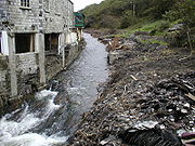
caught under a bridge and then being suddenly released as the bridge collapsed, surged down the main road. Water speed was over 4 m/s (10 mph), more than enough to cause structural damage. It is estimated that 20000000 cubic metres (5,283,440,745.7 US gal) of water flowed through Boscastle that day alone. The steep valley sides, and the saturated surface ensured a high amount of surface run-off.
Changes in farming practice in the area also possibly contributed, sewage could have been a cause as well, with a reduction of trees and hedges higher up the valley causing water to flow through more quickly than would have been the case in the past. Fortunately, no one died in the flood
Flood
A flood is an overflow of an expanse of water that submerges land. The EU Floods directive defines a flood as a temporary covering by water of land not normally covered by water...
.
However, an episode of Discovery Channel
Discovery Channel
Discovery Channel is an American satellite and cable specialty channel , founded by John Hendricks and distributed by Discovery Communications. It is a publicly traded company run by CEO David Zaslav...
's Perfect Disaster
Perfect Disaster
Perfect Disaster was a one-hour American documentary television mini-series that premiered in 2006 on the Discovery Channel. The program depicted the worst-case scenario that major cities could expect in the near future if hit by extreme disaster...
states that the floods might have been caused by a phenomenon called a "blocking high". A blocking high is a large area of static high pressure. It can happen anywhere in the world, and the effect is deadly because the high pressure can stall other weather systems around it.
Impact of the flood
75 cars, 5 caravans, 6 buildings and several boats were washed into the sea; approximately 100 homes and businesses were destroyed; trees were uprooted and debris were scattered over a large area. In an operation lasting from mid-afternoon until 2:30 AM, a fleet of 7 helicopterHelicopter
A helicopter is a type of rotorcraft in which lift and thrust are supplied by one or more engine-driven rotors. This allows the helicopter to take off and land vertically, to hover, and to fly forwards, backwards, and laterally...
s rescued about 150 people clinging to trees and the roofs of buildings and cars. No major injuries or loss of life were reported.
Work since the flood
2004
- August: Buildings searched, buried cars removed from harbour, trees removed, roads cleared, B3263 bridge temporary concrete parapets installed.
- 20 August: Boscastle Coast Path closed
- 14 September: Work started on the overflow culvert for the Valency River.
- December: Overflow culvert work completed.Also many hard sticks were inserted into the ground so it would create a barrier against the flood.
2005
- Early 2005: Most shops and restaurants re-open with new customers.
- Boscastle power system renewed
- Water supply restored
- Food supply restored
- The flood defences were increased
- Defences improved strongly
- Boscastle rebuilt
2006
- 30 October: Work on two underground pumping stations for the sewage treatment scheme began.
- 1 November: Work started to widen and lower the river channel to increase capacity.
- December: A new visitor centre opened, in the former Harbour Restaurant, bought by the National Trust.
- December: The car park level was raised, and extended, reducing the risk of cars being washed away .
2007
- January: Work started on the 'gateway building' next to the car park, to contain toilets, a bus shelter, and information boards.
- April: Work stopped on gateway building due to problems with planning permission, and the building being built taller than expected.
- 21 June: Boscastle reflooded, although it was not nearly as bad as during the 2004 floods.
- September: Work restarted on Gateway Building, after planning permission is approved to lower the height of the building
- October: Work started on rebuilding an old culvert at the top of the village, to allow more water to flow through in periods of heavy rain.
- October: Work started on installing the pipes for the new sewage treatments works, in the harbour area (between the Lower and Upper bridges).
- 12 November: The main road in the harbour area was closed, from the bridge to the car park, while Cormac started work on new wider pavements, and Carillion installed pipes under the road for the new sewage treatment works.
- 14 December: The main road in the harbour area was reopened and temporary traffic lights put in place.
- 18 December: The new lower bridge was installed.
2008
- January: Work on improving the harbour pavements completed. Work on rebuilding the culvert next to the petrol station completed.
- February: Work began on renewing the culvert in Dunn Street, to allow more water through in times of heavy rain.
- March: The Harbour area road was resurfaced. Work on rebuilding the culvert in Dunn Street completed.
- April: Old Lower Bridge was demolished, and the new Lower Bridge was brought into use.
The lower bridge
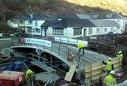
During the flood of 2004, 14 cars became lodged beneath it, this had caused a huge backlog of flood water and debris, adding to the damage caused in the surrounding area.
The original proposal was for a stone bridge, this was rejected. The second proposal is for a modern concrete bridge, with steel railings. Public consultations were held and villagers were asked to select their preference from four designs; most did not choose the one which has been proposed. This plan was rejected.
The new bridge is a few metres further down the river than the old bridge. The bridge was installed on 18 December 2007, and was made by Cornish Concrete, a company based near Truro
Truro
Truro is a city and civil parish in Cornwall, England, United Kingdom. The city is the centre for administration, leisure and retail in Cornwall, with a population recorded in the 2001 census of 17,431. Truro urban statistical area, which includes parts of surrounding parishes, has a 2001 census...
. The main arch is made from concrete, with metal railings.
The old stone bridge, which was over 100 years old, was demolished in early April 2008.
Mini flood - 21 June 2007
Boscastle flooded again, although not nearly as badly as the 2004 floods. After an afternoon of intense localised rainfall, and a week of steady rain everyday, a small flood happened on 21 June 2007. 30 mm fell on the area in one hour. Roads had become flooded in the area and in the village, most water came from the saturated fields around the village. Many drains had become blocked. Roads around the Tintagel, Camelford and Davidstow area were closed off to stop people visiting the village. River levels were alarmingly high, but the banks contained the water. However the many culverts of the River Jordan had overflowed onto the villages roads, adding to the amount of water on the roads. The new storm culvert joining the River Jordan to the River Valency was at full capacity, but did not flood. Services and organisations called in included:- Fire crews from BudeBudeBude is a small seaside resort town in North Cornwall, England, at the mouth of the River Neet . It lies just south of Flexbury, north of Widemouth Bay and west of Stratton and is located along the A3073 road off the A39. Bude is twinned with Ergué-Gabéric in Brittany, France...
, DelaboleDelaboleDelabole is a large village in north Cornwall, England, UK. It is situated approximately two miles west of Camelford.The village of Delabole came into existence in the 20th century; it is named after the Delabole Quarry. There were three hamlets: Pengelly, Medrose and Rockhead...
and Launceston to pump out the water from properties - Crews to unblock the blocked up drains in the village
- The Environment Agency
- The Police and Council
- Helicopters from RNAS Culdrose and RMB Chivenor were on stand-by
- Boscastle Coast Guard
The Environment Agency's flood defences installed after the 2004 flood worked and kept the water in the river channel. A few properties in the village were flooded by 3 ft (0.9144 m) from water flowing down the streets, rather than from the river flooding, although the damage was not nearly as bad as the 2004 flood. The two main roads (B3266, B3263) were blocked with flood waste and debris, although this was cleared and the roads reopened the following morning. The Environment Agency looked at the culverts around the village and will change them all to modern drainage