
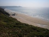
Whitsand Bay
Encyclopedia

Cornwall
Cornwall is a unitary authority and ceremonial county of England, within the United Kingdom. It is bordered to the north and west by the Celtic Sea, to the south by the English Channel, and to the east by the county of Devon, over the River Tamar. Cornwall has a population of , and covers an area of...
, England
England
England is a country that is part of the United Kingdom. It shares land borders with Scotland to the north and Wales to the west; the Irish Sea is to the north west, the Celtic Sea to the south west, with the North Sea to the east and the English Channel to the south separating it from continental...
, United Kingdom
United Kingdom
The United Kingdom of Great Britain and Northern IrelandIn the United Kingdom and Dependencies, other languages have been officially recognised as legitimate autochthonous languages under the European Charter for Regional or Minority Languages...
runs from Rame Head
Rame Head
Rame Head is a coastal headland, southwest of the village of Rame in southeast Cornwall, United Kingdom.-History and antiquities:The site was used for a hill fort in the Iron Age. The headland has a prominent chapel, dedicated to St Michael, accessible by a steep footpath...
in the east to Portwrinkle
Portwrinkle
Portwrinkle is a small coastal village in south-east Cornwall, United Kingdom. It is situated at the western end of Whitsand Bay five miles south-west of Saltash....
in the west. It is characterised by sheer, high cliffs, dramatic scenery and long stretches of sandy beaches. The South West Coast Path
South West Coast Path
The South West Coast Path is Britain's longest waymarked long-distance footpath and a National Trail. It stretches for , running from Minehead in Somerset, along the coasts of Devon and Cornwall, to Poole Harbour in Dorset. Since it rises and falls with every river mouth, it is also one of the more...
runs the length of the bay.
Geography
Rame Head
Rame Head is a coastal headland, southwest of the village of Rame in southeast Cornwall, United Kingdom.-History and antiquities:The site was used for a hill fort in the Iron Age. The headland has a prominent chapel, dedicated to St Michael, accessible by a steep footpath...
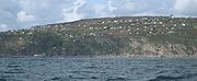
, a conical hill with the ruins of a 14th-century chapel dedicated to St Michael on top. Polhawn Cove is a rough beach, consisting of sharp rocks, shingle and an area of open sand. West of Captain Blake's Point, long stretches of sand are interspersed with rocky headlands and small bays, many inaccessible at high tide. The holiday settlements of Freathy
Freathy
Freathy is a beach and coastal settlement on the Rame Peninsula in east Cornwall, England, United Kingdom.Freathy is accessible by the coast road along which runs the South West Coast Path...
and Tregonhawke are built on terraces
Terrace (agriculture)
Terraces are used in farming to cultivate sloped land. Graduated terrace steps are commonly used to farm on hilly or mountainous terrain. Terraced fields decrease erosion and surface runoff, and are effective for growing crops requiring much water, such as rice...
on the cliff faces.
A National Trust
National Trust for Places of Historic Interest or Natural Beauty
The National Trust for Places of Historic Interest or Natural Beauty, usually known as the National Trust, is a conservation organisation in England, Wales and Northern Ireland...
property at Sharrow Point preserves a small cave excavated by hand in 1874 by a hermit called Lugger, who inscribed verses on the ceiling to relieve his boredom. Lugger's Cave is fenced off to the public.
The headland forms part of Rame Head
Rame Head
Rame Head is a coastal headland, southwest of the village of Rame in southeast Cornwall, United Kingdom.-History and antiquities:The site was used for a hill fort in the Iron Age. The headland has a prominent chapel, dedicated to St Michael, accessible by a steep footpath...
& Whitsand Bay SSSI (Site of Special Scientific Interest
Site of Special Scientific Interest
A Site of Special Scientific Interest is a conservation designation denoting a protected area in the United Kingdom. SSSIs are the basic building block of site-based nature conservation legislation and most other legal nature/geological conservation designations in Great Britain are based upon...
), noted for its geological
Geology of Cornwall
The Geology of Cornwall is dominated by its granite backbone, part of the Cornubian batholith, formed during the Variscan orogeny. Around this is an extensive metamorphic aureole formed in the mainly Devonian slates that make up most of the rest of the county...
as well as biological
Flora and fauna of Cornwall
Cornwall is the county that forms the tip of the southwestern peninsula of England; this area has a mild and warm climate regulated by the Gulf Stream...
interest. The SSSI contains 2 species on the Red Data Book of rare and endangered plant species
IUCN Red List
The IUCN Red List of Threatened Species , founded in 1963, is the world's most comprehensive inventory of the global conservation status of biological species. The International Union for Conservation of Nature is the world's main authority on the conservation status of species...
; early meadow-grass (poa infirma
Poa infirma
Poa infirma is a species of grass known by the common names weak bluegrass and early meadowgrass. It was first described from a specimen found in Colombia, but it is actually an introduced species in the Americas and is native to Europe. It grows in many types of habitat, including disturbed areas...
) and slender bird’s-foot-trefoil (from the lotus
Lotus (genus)
Lotus is a genus that includes bird's-foot trefoils and deervetches and contains many dozens of species distributed world-wide. Depending on the taxonomic authority, roughly between 70 and 150 are accepted. Lotus is a genus of legume and its members are adapted to a wide range of habitats, from...
genus).
General information
A campaign to stop the dumping of dreadged silt and sludge( 5.3 million tonnes since the 1980s) from the River Tamar and the port of Plymouth has been running for several years, after no success for several years in 2010 the group with the help of Sheryll MurraySheryll Murray
Sheryll Murray is a Conservative Party politician. She has been the Member of Parliament for South East Cornwall since the 2010 general election.-Early life:...
have secured an independent review of the dump site.The review has stated that no significant environmental impact has occurred and the dumping continues.
A UK Ministry of Defence firing range exists between Fort Tregantle
Fort Tregantle
Tregantle Fort in south east Cornwall is one of several forts surrounding Plymouth that were built as a result of a decision in Lord Palmerston's premiership to deter the French from attacking naval bases on the Channel coast.-History:...
at the western end of the bay and Trethill Cliffs near Portwrinkle
Portwrinkle
Portwrinkle is a small coastal village in south-east Cornwall, United Kingdom. It is situated at the western end of Whitsand Bay five miles south-west of Saltash....
, and this area is closed during Fort Tregantle
Fort Tregantle
Tregantle Fort in south east Cornwall is one of several forts surrounding Plymouth that were built as a result of a decision in Lord Palmerston's premiership to deter the French from attacking naval bases on the Channel coast.-History:...
firing range operations.
Whitsand Bay is popular with divers, and in 2004 the former Royal Navy
Royal Navy
The Royal Navy is the naval warfare service branch of the British Armed Forces. Founded in the 16th century, it is the oldest service branch and is known as the Senior Service...
frigate, HMS Scylla (F71)
HMS Scylla (F71)
HMS Scylla was a Leander-class frigate of the Royal Navy . She was built at Devonport Royal Dockyard and was the last RN frigate to be built at the Dockyard so far. Scylla was launched in August 1968 and commissioned in 1970...
, was scuppered to provide a new underwater reef. The Scylla was sunk nearby an existing WWII wreck, the Liberty Ship
Liberty ship
Liberty ships were cargo ships built in the United States during World War II. Though British in conception, they were adapted by the U.S. as they were cheap and quick to build, and came to symbolize U.S. wartime industrial output. Based on vessels ordered by Britain to replace ships torpedoed by...
James Eagan Layne
The beach does not have any toilets and access to the beach is steep, narrow and slippery. Whitsand Bay is a popular surfing
Surfing
Surfing' is a surface water sport in which the surfer rides a surfboard on the crest and face of a wave which is carrying the surfer towards the shore...
spot. A lifeguard
Lifeguard
A lifeguard supervises the safety and rescue of swimmers, surfers, and other water sports participants such as in a swimming pool, water park, or beach. Lifeguards are strong swimmers and trained in first aid, certified in water rescue using a variety of aids and equipment depending on...
service operates between May and September.
Safety
There are dangerous rip currents. The western part of the beach is closed during firing range operation at Tregantle Fort, firing times are indicated by a red flag. The paths to the beaches at Sharrow Point, Withnoe, Tregonhawke and Freathy are steep, narrow and slippery and are not suitable for wheelchairs. There is a risk of being cut off at high tide, so keep close to beach access points.Whitsand Bay Fortifications
The 1859 Royal Commission on the Defence of the United KingdomRoyal Commission on the Defence of the United Kingdom
In 1859 Lord Palmerston instigated the Royal Commission on the Defence of the United Kingdom because of serious concerns that France might attempt to invade the UK...
identified Whitsand Bay as a weak point in the defences of Plymouth
Plymouth
Plymouth is a city and unitary authority area on the coast of Devon, England, about south-west of London. It is built between the mouths of the rivers Plym to the east and Tamar to the west, where they join Plymouth Sound...
and proposed two Palmerston forts
Palmerston Forts
The Palmerston Forts are a group of forts and associated structures, around the coast of Britain.The forts were built during the Victorian period on the recommendations of the 1860 Royal Commission on the Defence of the United Kingdom, following concerns about the strength of the French Navy, and...
; Polhawn Battery at the eastern end, whose guns would cover the beaches and prevent an amphibious assault, and Fort Tregantle
Fort Tregantle
Tregantle Fort in south east Cornwall is one of several forts surrounding Plymouth that were built as a result of a decision in Lord Palmerston's premiership to deter the French from attacking naval bases on the Channel coast.-History:...
at the western end which prevented an overland approach.
Polhawn Battery
Constructed between 1862 and 1867; seven 64 pounder rifled muzzle-loading gunsRML 64 pounder 71 cwt gun
The RML 64 pounder 71 cwt guns were rifled muzzle-loading guns converted from obsolete smoothbore 8-inch 65 cwt shell guns. "71 cwt" refers to the gun's weight rounded up to differentiate it from other "64-pounder" guns : 1 cwt = 112 pounds....
were installed in armoured casemates. During World War I it was used for accommodation and was sold in 1927. It has recently been restored as a hotel and wedding venue.
Fort Tregantle
At the western end of Whitesand Bay, Fort TregantleFort Tregantle
Tregantle Fort in south east Cornwall is one of several forts surrounding Plymouth that were built as a result of a decision in Lord Palmerston's premiership to deter the French from attacking naval bases on the Channel coast.-History:...
stands 360 feet above sea level. It is hexagonal
Polygonal fort
A polygonal fort is a fortification in the style that evolved around the middle of the nineteenth century, in response to the development of powerful explosive shells....
in shape and is surrounded by a ditch on three sides. The fort was completed in 1865 and included a barracks designed for 1,000 men. It was intended to be armed with 22 7-inch guns but only seven were ever fitted. It was used for musketry training during World War I and gas warfare training and accommodation for US troops in World War II. It is currently part of the Defence Estate.
Whitsand Bay Battery
When the StanhopeEdward Stanhope
Edward Stanhope was a British Conservative Party politician.-Background and education:Born in London, Stanhope was the second son of Philip Stanhope, 5th Earl Stanhope, by his wife Emily Harriet, daughter of General Sir Edward Kerrison, 1st Baronet...
Committee reviewed the country's defences in 1887, it was realised that naval artillery had improved so much that it would have been possible for enemy warships to anchor in the Bay and bombard Plymouth without being threatened by the existing forts. To counter this threat, a battery of three 12.5 inch rifled muzzle-loaders
RML 12.5 inch 38 ton gun
The RML 12.5 inch guns were large rifled muzzle-loading guns designed for British battleships and were also employed for coast defence.-Design:The gun originated from a desire for a longer 12-inch gun than the existing RML 12 inch 35 ton gun...
and two 6 inch breech-loaders was constructed near Stone Farm at the top of Tregonhawke Cliff. The battery was strongly fortified against land attack with a dry moat protected by three caponier
Caponier
A caponier is a type of fortification structure. The word originates from the French word "caponnière" - which strictly means capon-cote i.e. chickenhouse.The fire coming from the feature A caponier is a type of fortification structure. The word originates from the French word "caponnière" -...
s. It was completed in 1893, but was fully disarmed after World War I. It was released by the military in 1951 and became a caravan park. Although the ditch has been filled-in, many of the original features can still be seen.