

Godrevy
Encyclopedia
Cornwall
Cornwall is a unitary authority and ceremonial county of England, within the United Kingdom. It is bordered to the north and west by the Celtic Sea, to the south by the English Channel, and to the east by the county of Devon, over the River Tamar. Cornwall has a population of , and covers an area of...
, United Kingdom, found on the north coast within St. Ives Bay and is popular with both the surfing
Surfing
Surfing' is a surface water sport in which the surfer rides a surfboard on the crest and face of a wave which is carrying the surfer towards the shore...
community and walkers. It is home also to some areas administered by the National Trust, and a lighthouse maintained by Trinity House
Trinity House
The Corporation of Trinity House of Deptford Strond is the official General Lighthouse Authority for England, Wales and other British territorial waters...
.
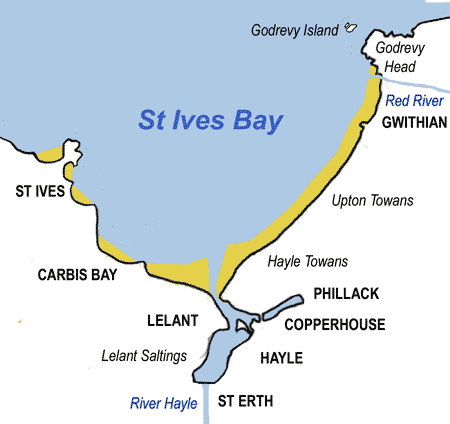
Godrevy Head
The headlandHeadlands and bays
Headlands and bays are two related features of the coastal environment.- Geology and geography :Headlands and bays are often found on the same coastline. A bay is surrounded by land on three sides, whereas a headland is surrounded by water on three sides. Headlands are characterized by high,...
is on the Atlantic
Atlantic Ocean
The Atlantic Ocean is the second-largest of the world's oceanic divisions. With a total area of about , it covers approximately 20% of the Earth's surface and about 26% of its water surface area...
coast in Cornwall
Cornwall
Cornwall is a unitary authority and ceremonial county of England, within the United Kingdom. It is bordered to the north and west by the Celtic Sea, to the south by the English Channel, and to the east by the county of Devon, over the River Tamar. Cornwall has a population of , and covers an area of...
. It is on the eastern side of St Ives
St Ives, Cornwall
St Ives is a seaside town, civil parish and port in Cornwall, England, United Kingdom. The town lies north of Penzance and west of Camborne on the coast of the Celtic Sea. In former times it was commercially dependent on fishing. The decline in fishing, however, caused a shift in commercial...
Bay, about three miles (5 km) north-east of the town of Hayle
Hayle
Hayle is a small town, civil parish and cargo port in west Cornwall, United Kingdom. It is situated at the mouth of the Hayle River and is approximately seven miles northeast of Penzance...
. The nearest village is Gwithian
Gwithian
beach2Gwithian is a coastal village in west Cornwall, United Kingdom. It is situated three miles northeast of Hayle and four miles east of St Ives, Cornwall across St Ives Bay....
, half-a-mile west beyond Godrevy Bridge across the Red River
Red River, Cornwall
The Red River is a small river in north-west Cornwall, UK which issues into St Ives Bay at Godrevy on Cornwall's Atlantic coast. The Red River is approx 8 miles long and gets its name from the mineral deposits associated with tin mining which formerly coloured its water red...
.
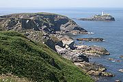
The promontory
Promontory
Promontory may refer to:*Promontory, a prominent mass of land which overlooks lower lying land or a body of water*Promontory, Utah, the location where the United States first Transcontinental Railroad was completed...
is roughly square in shape, faces north into the Atlantic and occupies an area of approx 1 square miles (2.6 km²). The coastline around the headland and two inland areas of maritime heathland are owned by the National Trust
National Trust for Places of Historic Interest or Natural Beauty
The National Trust for Places of Historic Interest or Natural Beauty, usually known as the National Trust, is a conservation organisation in England, Wales and Northern Ireland...
.
Godrevy Head has some of the best coastal heathland in the county, with many species of plant, animal and insect life. Areas of Godrevy Head are classified as sites of special scientific interest (SSSI).
Much of the headland is open to the public and the area is popular with walkers. The South West Coast Path
South West Coast Path
The South West Coast Path is Britain's longest waymarked long-distance footpath and a National Trail. It stretches for , running from Minehead in Somerset, along the coasts of Devon and Cornwall, to Poole Harbour in Dorset. Since it rises and falls with every river mouth, it is also one of the more...
runs around the whole promontory and there are several public car parks on the western side where the National Trust owns and operates a cafe. There is also easy access to the coast path from the B3301 road at Hell's Mouth, south-east of Godrevy Head.
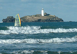
The western side of the Godrevy Head is bounded by rocks to the north and a wide sandy beach to the south which is popular for surfing
Surfing
Surfing' is a surface water sport in which the surfer rides a surfboard on the crest and face of a wave which is carrying the surfer towards the shore...
. At the north-western corner of the headland is Godrevy Point; at the north-eastern corner is Navax Point. The cliffs between the two points are approx 220 feet (70 metres) above sea level.
On the northern side of the headland are two coves named Mutton Cove and Kynance Cove beyond which the Nathaga Rocks lie off Navax Point. On the eastern side of the headland are Castle Giver Cove and Fishing Cove.
South of Navax Point is an area of heath named The Knavocks which is managed by The National Trust. The grassland and gorse scrub is criss-crossed with footpaths and is home to many species of butterflies and birds, notably nesting stonechats. The Knavocks, like other coastal heathlands in Cornwall, is managed by regularly cutting back the gorse and by grazing, the National Trust having introduced a herd of ponies for the purpose.
Beyond Fishing Cove, the coast swings to the east towards Hell's Mouth and North Cliffs. The land here rises to approx 290 feet (90 metres), the highest point on this section of clifftop.
The cliffs, offshore rocks and coast around Godrevy Head form a renowned habitat for seabirds including cormorants, fulmar, guillemot, and razorbills and several species of gull. There is also a substantial population of grey seals throughout the year. Occasionally, bottlenose dolphins can be seen in the area.
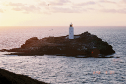
Godrevy Island lies approx three hundred yards off Godrevy Point. The uninhabited island is the site of an operational Trinity House
Trinity House
The Corporation of Trinity House of Deptford Strond is the official General Lighthouse Authority for England, Wales and other British territorial waters...
lighthouse
Lighthouse
A lighthouse is a tower, building, or other type of structure designed to emit light from a system of lamps and lenses or, in older times, from a fire, and used as an aid to navigation for maritime pilots at sea or on inland waterways....
(see below).
Seaward of Godrevy Island is a submerged reef known as the Stones which extends for approx one mile (1.6 km) across the eastern approach to St Ives Bay. Godrevy lighthouse was built to warn shipping of the danger posed by the reef.
Godrevy Lighthouse
Godrevy Lighthouse was built in 1858–1859. The Stones reef had always been a hazard to shipping and a lighthouseLighthouse
A lighthouse is a tower, building, or other type of structure designed to emit light from a system of lamps and lenses or, in older times, from a fire, and used as an aid to navigation for maritime pilots at sea or on inland waterways....
had been considered many times prior to 1858 but nothing came of plans until the SS Nile was wrecked in 1854 with the loss of all on board. The lighthouse is a white octagonal tower, 86 feet (26 m) high and made of rubble-stone and mortar. The original light was a revolving white one, with a fixed red light below the main light, which could be seen over a 45-degree arc when a ship was in danger of the reef. This was later replaced by a red sector on the main light itself. Originally, the light was manned by three men at a time, but in 1934 the lighthouse was automated. The light flashes white/red every 10 seconds, with the red sector only being visible in the arc of danger from the reef. The range of the light is around 12 miles (19.3 km).Godrevy Light by Charles Thomas and Jessica Mann describes the history of this lighthouse and shows the many works of art it inspired.
The lighthouse is said to have inspired Virginia Woolf
Virginia Woolf
Adeline Virginia Woolf was an English author, essayist, publisher, and writer of short stories, regarded as one of the foremost modernist literary figures of the twentieth century....
to write To the Lighthouse
To the Lighthouse
To the Lighthouse is a novel by Virginia Woolf. A novel set on the Ramsays and their visits to the Isle of Skye in Scotland between 1910 and 1920, it skilfully manipulates temporal and psychological elements....
- though in the book, she locates the lighthouse in the Hebrides
Hebrides
The Hebrides comprise a widespread and diverse archipelago off the west coast of Scotland. There are two main groups: the Inner and Outer Hebrides. These islands have a long history of occupation dating back to the Mesolithic and the culture of the residents has been affected by the successive...
. The lighthouse's visitor book, containing the signature of Virginia Stephen (Woolfe), is to go on sale at Bonhams
Bonhams
Bonhams is a privately owned British auction house founded in 1793. It is the third largest auctioneer after Sotheby's and Christie's, and conducts around 700 auctions per year. It has 700 employees....
on 22 November 2011. She first visited on 12 September 1892. Pre–Raphaelite
Pre-Raphaelite Brotherhood
The Pre-Raphaelite Brotherhood was a group of English painters, poets, and critics, founded in 1848 by William Holman Hunt, John Everett Millais and Dante Gabriel Rossetti...
painter William Holman Hunt
William Holman Hunt
William Holman Hunt OM was an English painter, and one of the founders of the Pre-Raphaelite Brotherhood.-Biography:...
also signed the book on the same day.
Godrevy in popular music
British singer Patrick WolfPatrick Wolf
Patrick Wolf is an English-Irish singer-songwriter from South London. Patrick utilises a wide variety of instruments in his music, most commonly the ukulele, piano and viola...
has written a song called Godrevy Point, which released as a B-side on the single Wind in the Wires
Wind in the Wires (song)
"Wind in the Wires" is the title track and second single from English singer-songwriter Patrick Wolf's second album. The single was released on CD and limited 2000 vinyl.-Charts:...
in 2005.
Further reading
- Godrevy Light by Charles ThomasCharles Thomas (historian)Antony Charles Thomas, CBE, FSA is a British historian and archaeologist who was Professor of Cornish Studies at Exeter University, and the first Director of the Institute of Cornish Studies, from 1971 until his retirement in 1991...
with Jessica MannJessica MannJessica Mann is a British writer. As a novelist she specialises in the mystery and suspense genres, having published 20 crime novels since 1971.She has also written several non-fiction books, including Out Of Harm's Way, the story of the overseas evacuation of children during WW2.Mann was educated...
, Truro: Twelveheads PressTwelveheads PressTwelveheads Press is an independent publishing company based in Chacewater near Truro, Cornwall, UK. Best known for their Cornish Heritage series but also well known by scholars and enthusiasts for their transport and mining books: the firm takes its name from the hamlet of Twelveheads.-History...
, 2009 ISBN 978-0-906294-70-3 - Godrevy Lighthouses - Worldwide Lighthouses http://www.worldwidelighthouses.com/Lighthouses/English-Lighthouses/Trinity-House-Owned/Godrevy.php